Bridge Statistics for Evans, New York (NY)
Condition, Traffic, Stress, Structural Evaluation, Project Costs
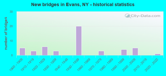
- New bridges - historical statistics
- 51900-1909
- 31910-1919
- 61920-1929
- 31930-1939
- 201950-1959
- 31970-1979
- 41990-1999
- 52000-2009
- 12020-2022
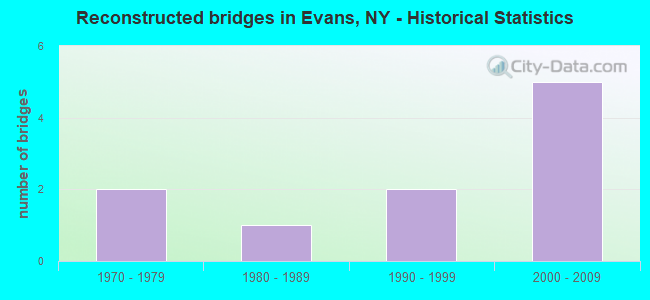
- Reconstructed bridges - Historical Statistics
- 21970-1979
- 11980-1989
- 21990-1999
- 52000-2009
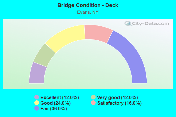
- Bridge Condition - Deck
- 12.0%Excellent
- 12.0%Very good
- 24.0%Good
- 16.0%Satisfactory
- 36.0%Fair
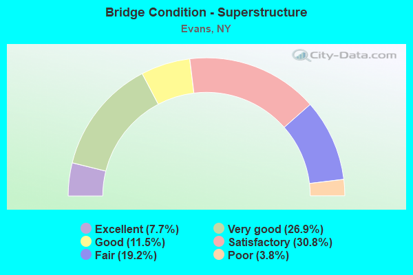
- Bridge Condition - Superstructure
- 7.7%Excellent
- 26.9%Very good
- 11.5%Good
- 30.8%Satisfactory
- 19.2%Fair
- 3.8%Poor
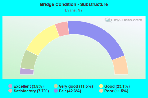
- Bridge Condition - Substructure
- 3.8%Excellent
- 11.5%Very good
- 23.1%Good
- 7.7%Satisfactory
- 42.3%Fair
- 11.5%Poor
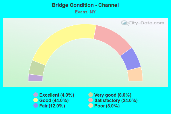
- Bridge Condition - Channel
- 4.0%Excellent
- 8.0%Very good
- 44.0%Good
- 24.0%Satisfactory
- 12.0%Fair
- 8.0%Poor
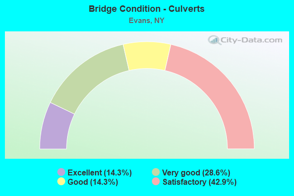
- Bridge Condition - Culverts
- 14.3%Excellent
- 28.6%Very good
- 14.3%Good
- 42.9%Satisfactory
Find on map >> Show street view
Structure Number: 100136, Location: 5.2 MI NE JCT RTS 5 + 249 (Lat: 42.657033, Lng: -79.035708), Route carried "on" structure: State highway 5, Year Built: 1928, Year Reconstructed: 1975, Status: Open, Structure Length: 2.90m (9.51ft), Average Daily Traffic: 8,653 (year 2019), Truck Traffic: 4%, Average Future Daily Traffic: 8,693 (year 2040), Features Intersected: BIG SISTER CREEK
Minimum Vertical Clearance: 30+ m (98+ ft), Kilometerpoint: 11.971, Lanes on structure: 4, Base Highway Network: Yes, Owner: State Highway Agency, Approaching Roadway Width: 14.6m (47.9ft), Material/Design: Steel, Design/Construction: Girder and Floorbeam System, Number Of Spans In Main Unit: 1, Length of Maximum Span: 27.4m (89.9ft), Curb or Sidewalk Widths: Left: 1.5m (4.9ft), Right: 1.5m (4.9ft), Curb-To-Curb Width: 12.1m (39.7ft), Out-to-Out Width: 13.3m (43.6ft)
Condition: Deck: Good, Superstructure: Satisfactory, Substructure: Poor, Channel: Good, Operating Rating: 37.2 metric tons, Method Used To Determine Operating Rating: Load Factor (LF), Inventory Rating: 21.8 metric tons, Method Used To Determine Inventory Rating: Load Factor (LF), Structural Evaluation: Meets minimum limits, Deck Geometry: High priority of replacement, Waterway Adequacy: Meets minimum limits, Approach Roadway Alignment: Equal to present desirable criteria, Length Of Structure Improvement: 2.89m (9.48ft), Designated Inspection Frequency: Every 24 months, Critical Feature Inspection Frequency: Every 24 months, Inspection Date: July 2020, Critical Feature Inspection Date: July 2020, Bridge Improvement Cost: $1,807,000, Roadway Improvement Cost: $1,058,000, Total Project Cost: $2,865,000 ( Estimate for 2021), Deck Structure Type: Concrete Cast-file-Place, Wearing Surface/Protective System: Wearing Surface: Integral Concrete
Find on map >> Show street view
Structure Number: 100137, Location: 8.3 MI NE JCT SH 5 & US20 (Lat: 42.669508, Lng: -79.027589), Route carried "on" structure: State highway 5, Year Built: 1927, Status: Open, Structure Length: 0.76m (2.49ft), Average Daily Traffic: 8,653 (year 2019), Truck Traffic: 4%, Average Future Daily Traffic: 8,693 (year 2040), Features Intersected: LITTLE SISTER CRK
Minimum Vertical Clearance: 30+ m (98+ ft), Kilometerpoint: 13.548, Lanes on structure: 4, Base Highway Network: Yes, Owner: State Highway Agency, Approaching Roadway Width: 14.9m (48.9ft), Material/Design: Concrete, Design/Construction: Slab, Number Of Spans In Main Unit: 1, Length of Maximum Span: 7.3m (24.0ft), Curb-To-Curb Width: 14.3m (46.9ft), Out-to-Out Width: 15.1m (49.5ft)
Condition: Deck: Fair, Superstructure: Poor, Substructure: Satisfactory, Channel: Good, Operating Rating: 64.4 metric tons, Method Used To Determine Operating Rating: Load Factor (LF), Inventory Rating: 38.1 metric tons, Method Used To Determine Inventory Rating: Load Factor (LF), Structural Evaluation: Meets minimum limits, Deck Geometry: High priority of replacement, Waterway Adequacy: Somewhat better than minimum adequacy, Approach Roadway Alignment: Equal to present desirable criteria, Length Of Structure Improvement: 0.76m (2.49ft), Designated Inspection Frequency: Every 24 months, Inspection Date: July 2021, Bridge Improvement Cost: $506,000, Roadway Improvement Cost: $296,000, Total Project Cost: $802,000 ( Estimate for 2021), Wearing Surface/Protective System: Wearing Surface: Bituminous, Membrane: Other
Find on map >> Show street view
Structure Number: 100138, Location: 5.2 MI NE JCT RTS 5 + 323 (Lat: 42.708775, Lng: -78.963597), Route carried "on" structure: State highway 5, Year Built: 1931, Year Reconstructed: 2012, Status: Open, Structure Length: 14.60m (47.90ft), Average Daily Traffic: 10,493 (year 2019), Truck Traffic: 4%, Average Future Daily Traffic: 10,542 (year 2040), Design Load: HS 20, Features Intersected: EIGHTEEN MILE CR
Minimum Vertical Clearance: 30+ m (98+ ft), Kilometerpoint: 20.466, Lanes on structure: 4, Base Highway Network: Yes, Owner: State Highway Agency, Approaching Roadway Width: 17.7m (58.1ft), Skew: 3 degrees, Material/Design: Concrete, Design/Construction: Arch - Deck, Number Of Spans In Main Unit: 5, Length of Maximum Span: 34.7m (113.8ft), Curb-To-Curb Width: 17.5m (57.4ft), Out-to-Out Width: 18.5m (60.7ft)
Condition: Deck: Very good, Superstructure: Very good, Substructure: Very good, Channel: Good, Operating Rating: 61.7 metric tons, Method Used To Determine Operating Rating: Load Factor (LF), Inventory Rating: 37.2 metric tons, Method Used To Determine Inventory Rating: Load Factor (LF), Structural Evaluation: Equal to present desirable criteria, Deck Geometry: Somewhat better than minimum adequacy, Waterway Adequacy: Equal to present minimum criteria, Approach Roadway Alignment: Equal to present desirable criteria, Length Of Structure Improvement: 14.59m (47.87ft), Designated Inspection Frequency: Every 24 months, Critical Feature Inspection Frequency: Every 24 months, Inspection Date: October 2020, Critical Feature Inspection Date: October 2020, Bridge Improvement Cost: $13,030,000, Roadway Improvement Cost: $7,630,000, Total Project Cost: $20,660,000 ( Estimate for 2021), Deck Structure Type: Concrete Cast-file-Place, Wearing Surface/Protective System: Wearing Surface: Monolithic Concrete, Deck Protection: Epoxy Coated Reinforcing
Find on map >> Show street view
Structure Number: 101544, Location: 0.8 MI NE JCT RTS 20 +323 (Lat: 42.629189, Lng: -79.008342), Route carried "on" structure: US 20, Year Built: 1929, Year Reconstructed: 1978, Status: Open, Structure Length: 2.83m (9.28ft), Average Daily Traffic: 6,519 (year 2018), Truck Traffic: 10%, Average Future Daily Traffic: 6,580 (year 2040), Features Intersected: BIG SISTER CREEK
Minimum Vertical Clearance: 30+ m (98+ ft), Kilometerpoint: 10.475, Lanes on structure: 2, Base Highway Network: Yes, Owner: State Highway Agency, Approaching Roadway Width: 15.2m (49.9ft), Skew: 4 degrees, Material/Design: Concrete, Design/Construction: Arch - Deck, Number Of Spans In Main Unit: 1, Length of Maximum Span: 25.6m (84.0ft), Curb-To-Curb Width: 13.7m (44.9ft), Out-to-Out Width: 14.4m (47.2ft)
Condition: Superstructure: Satisfactory, Substructure: Poor, Channel: Good, Operating Rating: 44.8 metric tons, Method Used To Determine Operating Rating: Field evaluation and documented engineering judgment, Inventory Rating: 11.2 metric tons, Method Used To Determine Inventory Rating: Field evaluation and documented engineering judgment, Structural Evaluation: High priority of corrective action, Deck Geometry: Superior to present desirable criteria, Waterway Adequacy: Equal to present desirable criteria, Approach Roadway Alignment: Somewhat better than minimum adequacy, Length Of Structure Improvement: 2.83m (9.28ft), Designated Inspection Frequency: Every 24 months, Inspection Date: April 2020, Bridge Improvement Cost: $1,804,000, Roadway Improvement Cost: $1,056,000, Total Project Cost: $2,860,000 ( Estimate for 2021), Wearing Surface/Protective System: Wearing Surface: Bituminous
Find on map >> Show street view
Structure Number: 104572, Location: 1.8 MI SE OF ANGOLA (Lat: 42.613028, Lng: -79.017169), Route carried "on" structure: County highway , Year Built: 1957, Status: Open, Structure Length: 11.03m (36.19ft), Average Daily Traffic: 2,049 (year 2017), Truck Traffic: 6%, Average Future Daily Traffic: 2,869 (year 2037), Design Load: HS 20+Mod, Features Intersected: 90IX EB, RTE I90, Facility Carried by Structure: CR 9 ANGOLA BRANT
Minimum Vertical Clearance: 30+ m (98+ ft), Kilometerpoint: 5.133, Lanes on structure: 2, Lanes under structure: 4, Owner: State Toll Authority, Approaching Roadway Width: 13.1m (43.0ft), Skew: 4 degrees, Material/Design: Steel, Design/Construction: Stringer/Multi-beam, Number Of Spans In Main Unit: 5, Length of Maximum Span: 25.3m (83.0ft), Curb or Sidewalk Widths: Left: 0.8m (2.6ft), Right: 0.8m (2.6ft), Curb-To-Curb Width: 9.8m (32.2ft), Out-to-Out Width: 11.9m (39.0ft)
Condition: Deck: Fair, Superstructure: Satisfactory, Substructure: Fair, Operating Rating: 45.0 metric tons, Method Used To Determine Operating Rating: Load and Resistance Factor Rating (LRFR) rating reported by rating factor(RF) method using HL-93 loadings, Inventory Rating: 34.7 metric tons, Method Used To Determine Inventory Rating: Load and Resistance Factor Rating (LRFR) rating reported by rating factor(RF) method using HL-93 loadings, Structural Evaluation: Somewhat better than minimum adequacy, Deck Geometry: Meets minimum limits, Underclear: High priority of corrective action, Approach Roadway Alignment: Equal to present minimum criteria, Length Of Structure Improvement: 11.03m (36.19ft), Designated Inspection Frequency: Every 24 months, Inspection Date: November 2020, Bridge Improvement Cost: $4,608,000, Roadway Improvement Cost: $2,699,000, Total Project Cost: $7,307,000 ( Estimate for 2021), Deck Structure Type: Concrete Cast-file-Place, Wearing Surface/Protective System: Wearing Surface: Bituminous, Membrane: Other
Find on map >> Show street view
Structure Number: 104574, Location: .4 MILE S JCT SH 5 & CR 9 (Lat: 42.654961, Lng: -79.033597), Route carried "on" structure: County highway , Year Built: 2003, Status: Open, Structure Length: 2.68m (8.79ft), Average Daily Traffic: 1,039 (year 2017), Truck Traffic: 3%, Average Future Daily Traffic: 1,285 (year 2040), Design Load: HS 25 or greater, Features Intersected: BIG SISTER CREEK, Facility Carried by Structure: NORTH MAIN STREET
Minimum Vertical Clearance: 30+ m (98+ ft), Kilometerpoint: 10.298, Lanes on structure: 2, Owner: County Highway Agency, Approaching Roadway Width: 9.1m (29.9ft), Material/Design: Prestressed concrete, Design/Construction: Box Beam or Girders - Multiple, Number Of Spans In Main Unit: 1, Length of Maximum Span: 25.4m (83.3ft), Curb or Sidewalk Widths: Left: 1.7m (5.6ft), Right: 0.0m, Curb-To-Curb Width: 9.0m (29.5ft), Out-to-Out Width: 11.7m (38.4ft)
Condition: Deck: Very good, Superstructure: Very good, Substructure: Good, Channel: Satisfactory, Inventory Rating: 42.0 metric tons, Method Used To Determine Inventory Rating: Load Factor (LF), Structural Evaluation: Better than present minimum criteria, Deck Geometry: Somewhat better than minimum adequacy, Waterway Adequacy: Superior to present desirable criteria, Approach Roadway Alignment: Equal to present desirable criteria, Length Of Structure Improvement: 2.68m (8.79ft), Designated Inspection Frequency: Every 24 months, Inspection Date: May 2021, Bridge Improvement Cost: $827,000, Roadway Improvement Cost: $484,000, Total Project Cost: $1,311,000 ( Estimate for 2021), Deck Structure Type: Concrete Cast-file-Place, Wearing Surface/Protective System: Wearing Surface: Integral Concrete, Deck Protection: Galvanized Reinforcing
Find on map >> Show street view
Structure Number: 107747, Location: 2.8 MI NW JCT RTS 5 & 249 (Lat: 42.629778, Lng: -79.053794), Route carried "on" structure: State highway 5, Year Built: 2000, Status: Open, Structure Length: 0.85m (2.79ft), Average Daily Traffic: 5,577 (year 2018), Truck Traffic: 4%, Average Future Daily Traffic: 5,603 (year 2040), Design Load: HS 25 or greater, Features Intersected: DELAWARE CREEK
Minimum Vertical Clearance: 30+ m (98+ ft), Kilometerpoint: 8.624, Lanes on structure: 4, Base Highway Network: Yes, Owner: State Highway Agency, Approaching Roadway Width: 14.9m (48.9ft), Skew: 22 degrees, Material/Design: Concrete, Design/Construction: Culvert, Number Of Spans In Main Unit: 1, Length of Maximum Span: 8.2m (26.9ft), Curb-To-Curb Width: 17.5m (57.4ft), Out-to-Out Width: 18.4m (60.4ft)
Condition: Channel: Excellent, Culverts: Very good, Operating Rating: 50.8 metric tons, Method Used To Determine Operating Rating: Load Factor (LF), Inventory Rating: 30.8 metric tons, Method Used To Determine Inventory Rating: Load Factor (LF), Structural Evaluation: Better than present minimum criteria, Deck Geometry: Somewhat better than minimum adequacy, Waterway Adequacy: Equal to present minimum criteria, Approach Roadway Alignment: Equal to present desirable criteria, Length Of Structure Improvement: 0.85m (2.79ft), Designated Inspection Frequency: Every 24 months, Inspection Date: April 2020, Bridge Improvement Cost: $434,000, Roadway Improvement Cost: $254,000, Total Project Cost: $688,000 ( Estimate for 2021), Wearing Surface/Protective System: Wearing Surface: Bituminous, Membrane: Other
Find on map >> Show street view
Structure Number: 22132, Location: 1.5 MI. NE OF FARNHAM (Lat: 42.614933, Lng: -79.081444), Route carried "on" structure: Other road , Year Built: 1933, Status: Open, Structure Length: 0.82m (2.69ft), Average Daily Traffic: 618 (year 2016), Truck Traffic: 3%, Average Future Daily Traffic: 865 (year 2036), Features Intersected: MUDDY CREEK, Facility Carried by Structure: REEVES ROAD
Minimum Vertical Clearance: 30+ m (98+ ft), Kilometerpoint: 1.400, Lanes on structure: 2, Owner: Town or Township Highway Agency, Approaching Roadway Width: 6.1m (20.0ft), Skew: 3 degrees, Material/Design: Steel, Design/Construction: Stringer/Multi-beam, Number Of Spans In Main Unit: 1, Length of Maximum Span: 7.6m (24.9ft), Curb-To-Curb Width: 7.3m (24.0ft), Out-to-Out Width: 8.4m (27.6ft)
Condition: Deck: Fair, Superstructure: Fair, Substructure: Fair, Channel: Poor, Operating Rating: 74.4 metric tons, Method Used To Determine Operating Rating: Load Factor (LF), Inventory Rating: 44.5 metric tons, Method Used To Determine Inventory Rating: Load Factor (LF), Structural Evaluation: Somewhat better than minimum adequacy, Deck Geometry: Meets minimum limits, Waterway Adequacy: Meets minimum limits, Approach Roadway Alignment: Meets minimum limits, Length Of Structure Improvement: 0.82m (2.69ft), Designated Inspection Frequency: Every 24 months, Inspection Date: November 2020, Bridge Improvement Cost: $592,000, Roadway Improvement Cost: $347,000, Total Project Cost: $939,000 ( Estimate for 2021), Deck Structure Type: Concrete Cast-file-Place, Wearing Surface/Protective System: Wearing Surface: Bituminous
Find on map >> Show street view
Structure Number: 226381, Location: 1.3 MI NE OF DERBY (Lat: 42.695953, Lng: -78.957808), Route carried "on" structure: Other road , Year Built: 1992, Status: Open, Structure Length: 11.03m (36.19ft), Average Daily Traffic: 667 (year 2020), Truck Traffic: 6%, Average Future Daily Traffic: 934 (year 2040), Design Load: HS 20, Features Intersected: CSX/AMTRAK (&NSRR), NORF, Facility Carried by Structure: OVERHEAD BRDGE RD
Minimum Vertical Clearance: 30+ m (98+ ft), Kilometerpoint: 0.402, Lanes on structure: 2, Owner: Town or Township Highway Agency, Approaching Roadway Width: 7.3m (24.0ft), Material/Design: Steel continuous, Design/Construction: Stringer/Multi-beam, Number Of Spans In Main Unit: 4, Length of Maximum Span: 31.6m (103.7ft), Curb-To-Curb Width: 7.3m (24.0ft), Out-to-Out Width: 8.1m (26.6ft)
Condition: Deck: Very good, Superstructure: Satisfactory, Substructure: Very good, Operating Rating: 89.8 metric tons, Method Used To Determine Operating Rating: Load Factor (LF), Inventory Rating: 45.4 metric tons, Method Used To Determine Inventory Rating: Load Factor (LF), Structural Evaluation: Equal to present minimum criteria, Deck Geometry: Meets minimum limits, Underclear: Superior to present desirable criteria, Approach Roadway Alignment: Equal to present desirable criteria, Length Of Structure Improvement: 11.03m (36.19ft), Designated Inspection Frequency: Every 24 months, Inspection Date: November 2020, Bridge Improvement Cost: $3,514,000, Roadway Improvement Cost: $2,058,000, Total Project Cost: $5,572,000 ( Estimate for 2021), Deck Structure Type: Concrete Cast-file-Place, Wearing Surface/Protective System: Wearing Surface: Integral Concrete, Deck Protection: Epoxy Coated Reinforcing
Find on map >> Show street view
Structure Number: 226878, Location: 1.66 MI W VILLAGE ANGOLA (Lat: 42.644181, Lng: -79.063194), Route carried "on" structure: Other road , Year Built: 1997, Status: Posted for load, Structure Length: 2.77m (9.09ft), Average Daily Traffic: 18 (year 2018), Average Future Daily Traffic: 25 (year 2038), Features Intersected: DELAWARE CREEK, Facility Carried by Structure: AHLERS ROAD
Minimum Vertical Clearance: 30+ m (98+ ft), Kilometerpoint: 0.064, Lanes on structure: 1, Owner: Town or Township Highway Agency, Approaching Roadway Width: 4.6m (15.1ft), Material/Design: Steel, Design/Construction: Truss - Thru, Number Of Spans In Main Unit: 1, Number Of Approach Spans: 3, Length of Maximum Span: 18.2m (59.7ft), Curb-To-Curb Width: 3.7m (12.1ft), Out-to-Out Width: 4.7m (15.4ft)
Condition: Deck: Satisfactory, Superstructure: Fair, Substructure: Fair, Channel: Fair, Operating Rating: 9.1 metric tons, Method Used To Determine Operating Rating: Field evaluation and documented engineering judgment, Inventory Rating: 9.1 metric tons, Method Used To Determine Inventory Rating: Field evaluation and documented engineering judgment, Structural Evaluation: High priority of corrective action, Deck Geometry: Meets minimum limits, Waterway Adequacy: Meets minimum limits, Approach Roadway Alignment: High priority of corrective action, Bridge Posting: Required (Relationship of Operating Rating to Maximum Legal Load: > 39.9% below), Length Of Structure Improvement: 2.77m (9.09ft), Designated Inspection Frequency: Every 12 months, Critical Feature Inspection Frequency: Every 12 months, Underwater Inspection Frequency: Every 60 months, Inspection Date: December 2021, Critical Feature Inspection Date: December 2021, Underwater Inspection Date: August 2017, Bridge Improvement Cost: $756,000, Roadway Improvement Cost: $443,000, Total Project Cost: $1,199,000 ( Estimate for 2021), Deck Structure Type: Open Grating, Wearing Surface/Protective System: Wearing Surface: Other
Find on map >> Show street view
Structure Number: 332739, Location: 2.4 MI NW OF N COLLINS (Lat: 42.624167, Lng: -78.968972), Route carried "on" structure: County highway , Year Built: 1928, Year Reconstructed: 1980, Status: Posted for load-capacity, Structure Length: 3.54m (11.61ft), Average Daily Traffic: 2,479 (year 2017), Truck Traffic: 5%, Average Future Daily Traffic: 3,471 (year 2037), Design Load: HS 20, Features Intersected: BIG SISTER CREEK, Facility Carried by Structure: VERSAILLES PLANK
Minimum Vertical Clearance: 30+ m (98+ ft), Kilometerpoint: 4.811, Lanes on structure: 2, Owner: County Highway Agency, Approaching Roadway Width: 6.1m (20.0ft), Material/Design: Steel, Design/Construction: Girder and Floorbeam System, Number Of Spans In Main Unit: 2, Length of Maximum Span: 16.7m (54.8ft), Curb-To-Curb Width: 10.4m (34.1ft), Out-to-Out Width: 11.3m (37.1ft)
Condition: Deck: Satisfactory, Superstructure: Satisfactory, Substructure: Fair, Channel: Satisfactory, Operating Rating: 84.6 metric tons, Method Used To Determine Operating Rating: Field evaluation and documented engineering judgment, Inventory Rating: 32.7 metric tons, Method Used To Determine Inventory Rating: Field evaluation and documented engineering judgment, Structural Evaluation: Somewhat better than minimum adequacy, Deck Geometry: Somewhat better than minimum adequacy, Waterway Adequacy: Meets minimum limits, Approach Roadway Alignment: Equal to present desirable criteria, Length Of Structure Improvement: 3.53m (11.58ft), Designated Inspection Frequency: Every 24 months, Critical Feature Inspection Frequency: Every 24 months, Inspection Date: August 2020, Critical Feature Inspection Date: August 2020, Bridge Improvement Cost: $2,499,000, Roadway Improvement Cost: $1,463,000, Total Project Cost: $3,963,000 ( Estimate for 2021), Deck Structure Type: Concrete Cast-file-Place, Wearing Surface/Protective System: Wearing Surface: Integral Concrete, Deck Protection: Epoxy Coated Reinforcing
Find on map >> Show street view
Structure Number: 33274, Location: 2.9 MILES EAST OF ANGOLA (Lat: 42.639783, Lng: -78.970372), Route carried "on" structure: County highway , Year Built: 1937, Status: Posted for load-capacity, Structure Length: 0.91m (2.99ft), Average Daily Traffic: 2,479 (year 2017), Truck Traffic: 5%, Average Future Daily Traffic: 3,471 (year 2037), Features Intersected: TRB BIG SISTER CK, Facility Carried by Structure: VERSAILLES PLANK
Minimum Vertical Clearance: 30+ m (98+ ft), Kilometerpoint: 6.565, Lanes on structure: 2, Owner: County Highway Agency, Approaching Roadway Width: 6.4m (21.0ft), Material/Design: Concrete, Design/Construction: Culvert, Number Of Spans In Main Unit: 1, Length of Maximum Span: 8.5m (27.9ft), Curb-To-Curb Width: 7.3m (24.0ft), Out-to-Out Width: 8.5m (27.9ft)
Condition: Channel: Satisfactory, Culverts: Satisfactory, Operating Rating: 68.1 metric tons, Method Used To Determine Operating Rating: Field evaluation and documented engineering judgment, Inventory Rating: 29.4 metric tons, Method Used To Determine Inventory Rating: Field evaluation and documented engineering judgment, Structural Evaluation: Equal to present minimum criteria, Deck Geometry: High priority of replacement, Waterway Adequacy: Superior to present desirable criteria, Approach Roadway Alignment: Meets minimum limits, Length Of Structure Improvement: 0.91m (2.99ft), Designated Inspection Frequency: Every 24 months, Inspection Date: November 2020, Bridge Improvement Cost: $417,000, Roadway Improvement Cost: $244,000, Total Project Cost: $661,000 ( Estimate for 2021)
Find on map >> Show street view
Structure Number: 332745, Location: 1.4 MI W JCT SH 5 & SH323 (Lat: 42.657794, Lng: -79.059258), Route carried "on" structure: County highway , Year Built: 2000, Status: Open, Structure Length: 3.51m (11.52ft), Average Daily Traffic: 584 (year 2019), Truck Traffic: 4%, Average Future Daily Traffic: 722 (year 2040), Design Load: HS 25 or greater, Features Intersected: BIG SISTER CREEK, Facility Carried by Structure: LAKE SHORE ROAD
Minimum Vertical Clearance: 30+ m (98+ ft), Kilometerpoint: 10.072, Lanes on structure: 2, Owner: County Highway Agency, Approaching Roadway Width: 9.4m (30.8ft), Skew: 2 degrees, Material/Design: Steel, Design/Construction: Stringer/Multi-beam, Number Of Spans In Main Unit: 1, Length of Maximum Span: 34.0m (111.5ft), Curb-To-Curb Width: 9.6m (31.5ft), Out-to-Out Width: 10.6m (34.8ft)
Condition: Deck: Excellent, Superstructure: Excellent, Substructure: Satisfactory, Channel: Good, Operating Rating: 89.8 metric tons, Method Used To Determine Operating Rating: Load Factor (LF), Inventory Rating: 54.4 metric tons, Method Used To Determine Inventory Rating: Load Factor (LF), Structural Evaluation: Equal to present minimum criteria, Deck Geometry: Equal to present minimum criteria, Waterway Adequacy: Somewhat better than minimum adequacy, Approach Roadway Alignment: Equal to present desirable criteria, Length Of Structure Improvement: 3.50m (11.48ft), Designated Inspection Frequency: Every 24 months, Inspection Date: August 2020, Bridge Improvement Cost: $2,039,000, Roadway Improvement Cost: $1,194,000, Total Project Cost: $3,232,000 ( Estimate for 2021), Deck Structure Type: Concrete Cast-file-Place, Wearing Surface/Protective System: Wearing Surface: Integral Concrete, Deck Protection: Epoxy Coated Reinforcing
Find on map >> Show street view
Structure Number: 332748, Location: 2 MILES NORTH OF FARNHAM (Lat: 42.623933, Lng: -79.094344), Route carried "on" structure: County highway , Year Built: 2001, Status: Open, Structure Length: 1.16m (3.81ft), Average Daily Traffic: 1,895 (year 2020), Truck Traffic: 3%, Average Future Daily Traffic: 2,344 (year 2040), Design Load: HS 25 or greater, Features Intersected: MUDDY CREEK, Facility Carried by Structure: LAKE SHORE ROAD
Minimum Vertical Clearance: 30+ m (98+ ft), Kilometerpoint: 5.020, Lanes on structure: 2, Owner: County Highway Agency, Approaching Roadway Width: 8.5m (27.9ft), Material/Design: Concrete, Design/Construction: Culvert, Number Of Spans In Main Unit: 1, Length of Maximum Span: 11.3m (37.1ft), Curb or Sidewalk Widths: Left: 1.5m (4.9ft), Right: 1.5m (4.9ft), Curb-To-Curb Width: 8.4m (27.6ft), Out-to-Out Width: 12.2m (40.0ft)
Condition: Channel: Satisfactory, Culverts: Very good, Operating Rating: 85.3 metric tons, Method Used To Determine Operating Rating: Load Factor (LF), Inventory Rating: 50.8 metric tons, Method Used To Determine Inventory Rating: Load Factor (LF), Structural Evaluation: Equal to present desirable criteria, Deck Geometry: Meets minimum limits, Waterway Adequacy: Equal to present minimum criteria, Approach Roadway Alignment: Equal to present desirable criteria, Length Of Structure Improvement: 1.15m (3.77ft), Designated Inspection Frequency: Every 24 months, Inspection Date: November 2020, Bridge Improvement Cost: $637,000, Roadway Improvement Cost: $373,000, Total Project Cost: $1,010,000 ( Estimate for 2021)
Find on map >> Show street view
Structure Number: 332749, Location: 1.75 MILES WEST OF ANGOLA (Lat: 42.643542, Lng: -79.062581), Route carried "on" structure: County highway , Year Built: 2006, Status: Open, Structure Length: 1.34m (4.40ft), Average Daily Traffic: 2,861 (year 2017), Truck Traffic: 3%, Average Future Daily Traffic: 3,539 (year 2040), Design Load: HS 25 or greater, Features Intersected: DELAWARE CREEK, Facility Carried by Structure: LAKE SHORE ROAD
Minimum Vertical Clearance: 30+ m (98+ ft), Kilometerpoint: 8.447, Lanes on structure: 2, Owner: County Highway Agency, Approaching Roadway Width: 11.6m (38.1ft), Material/Design: Concrete, Design/Construction: Culvert, Number Of Spans In Main Unit: 1, Length of Maximum Span: 12.8m (42.0ft), Curb-To-Curb Width: 11.4m (37.4ft), Out-to-Out Width: 12.4m (40.7ft)
Condition: Channel: Good, Culverts: Excellent, Operating Rating: 81.6 metric tons, Method Used To Determine Operating Rating: Field evaluation and documented engineering judgment, Inventory Rating: 40.8 metric tons, Method Used To Determine Inventory Rating: Field evaluation and documented engineering judgment, Structural Evaluation: Superior to present desirable criteria, Deck Geometry: Somewhat better than minimum adequacy, Waterway Adequacy: Equal to present minimum criteria, Approach Roadway Alignment: Meets minimum limits, Length Of Structure Improvement: 1.34m (4.40ft), Designated Inspection Frequency: Every 24 months, Inspection Date: November 2020, Bridge Improvement Cost: $1,003,000, Roadway Improvement Cost: $587,000, Total Project Cost: $1,590,000 ( Estimate for 2021)
Find on map >> Show street view
Structure Number: 33275, Location: 1.3 MI NW OF EVANS CENTER (Lat: 42.667175, Lng: -79.057428), Route carried "on" structure: County highway , Year Built: 1927, Status: Open, Structure Length: 1.04m (3.41ft), Average Daily Traffic: 1,034 (year 2020), Truck Traffic: 2%, Average Future Daily Traffic: 1,279 (year 2040), Features Intersected: LITTLE SISTER CRK, Facility Carried by Structure: LAKE SHORE ROAD
Minimum Vertical Clearance: 30+ m (98+ ft), Kilometerpoint: 11.150, Lanes on structure: 2, Owner: County Highway Agency, Approaching Roadway Width: 5.5m (18.0ft), Skew: 3 degrees, Material/Design: Steel, Design/Construction: Stringer/Multi-beam, Number Of Spans In Main Unit: 1, Length of Maximum Span: 9.7m (31.8ft), Curb-To-Curb Width: 6.3m (20.7ft), Out-to-Out Width: 7.3m (24.0ft)
Condition: Deck: Satisfactory, Superstructure: Good, Substructure: Poor, Channel: Fair, Inventory Rating: 59.9 metric tons, Method Used To Determine Inventory Rating: Load Factor (LF), Structural Evaluation: Meets minimum limits, Deck Geometry: High priority of replacement, Waterway Adequacy: Meets minimum limits, Approach Roadway Alignment: Meets minimum limits, Length Of Structure Improvement: 1.03m (3.38ft), Designated Inspection Frequency: Every 24 months, Inspection Date: September 2020, Bridge Improvement Cost: $542,000, Roadway Improvement Cost: $317,000, Total Project Cost: $859,000 ( Estimate for 2021), Deck Structure Type: Concrete Cast-file-Place, Wearing Surface/Protective System: Wearing Surface: Bituminous
Find on map >> Show street view
Structure Number: 332751, Location: .9 MI NW OF EVANS CENTER (Lat: 42.667531, Lng: -79.045642), Route carried "on" structure: County highway , Year Built: 1929, Status: Posted for load-capacity, Structure Length: 1.31m (4.30ft), Average Daily Traffic: 453 (year 2017), Average Future Daily Traffic: 634 (year 2037), Features Intersected: LITTLE SISTER CRK, Facility Carried by Structure: DENNIS ROAD
Minimum Vertical Clearance: 30+ m (98+ ft), Kilometerpoint: 0.611, Lanes on structure: 2, Owner: County Highway Agency, Approaching Roadway Width: 5.5m (18.0ft), Material/Design: Steel, Design/Construction: Stringer/Multi-beam, Number Of Spans In Main Unit: 1, Length of Maximum Span: 12.4m (40.7ft), Curb-To-Curb Width: 7.3m (24.0ft), Out-to-Out Width: 8.2m (26.9ft)
Condition: Deck: Fair, Superstructure: Fair, Substructure: Fair, Channel: Poor, Operating Rating: 66.2 metric tons, Method Used To Determine Operating Rating: Load Factor (LF), Inventory Rating: 39.9 metric tons, Method Used To Determine Inventory Rating: Load Factor (LF), Structural Evaluation: Somewhat better than minimum adequacy, Deck Geometry: Meets minimum limits, Waterway Adequacy: Better than present minimum criteria, Approach Roadway Alignment: Equal to present desirable criteria, Length Of Structure Improvement: 1.31m (4.30ft), Designated Inspection Frequency: Every 24 months, Inspection Date: October 2020, Bridge Improvement Cost: $605,000, Roadway Improvement Cost: $354,000, Total Project Cost: $959,000 ( Estimate for 2021), Deck Structure Type: Concrete Cast-file-Place, Wearing Surface/Protective System: Wearing Surface: Bituminous
Find on map >> Show street view
Structure Number: 332778, Location: 3.5 MILES NE OF ANGOLA (Lat: 42.669539, Lng: -79.002564), Route carried "on" structure: County highway , Year Built: 1991, Status: Open, Structure Length: 1.13m (3.71ft), Average Daily Traffic: 942 (year 2017), Truck Traffic: 3%, Average Future Daily Traffic: 1,319 (year 2037), Design Load: HS 20, Features Intersected: LITTLE SISTER CRK, Facility Carried by Structure: DELAMATER ROAD
Minimum Vertical Clearance: 30+ m (98+ ft), Kilometerpoint: 3.974, Lanes on structure: 2, Owner: County Highway Agency, Approaching Roadway Width: 9.8m (32.2ft), Skew: 4 degrees, Material/Design: Steel, Design/Construction: Stringer/Multi-beam, Number Of Spans In Main Unit: 1, Length of Maximum Span: 10.3m (33.8ft), Curb-To-Curb Width: 9.8m (32.2ft), Out-to-Out Width: 10.4m (34.1ft)
Condition: Deck: Good, Superstructure: Very good, Substructure: Very good, Channel: Satisfactory, Inventory Rating: 71.7 metric tons, Method Used To Determine Inventory Rating: Load Factor (LF), Structural Evaluation: Equal to present desirable criteria, Deck Geometry: Equal to present minimum criteria, Waterway Adequacy: Meets minimum limits, Approach Roadway Alignment: Equal to present desirable criteria, Length Of Structure Improvement: 1.12m (3.67ft), Designated Inspection Frequency: Every 24 months, Inspection Date: August 2021, Bridge Improvement Cost: $951,000, Roadway Improvement Cost: $557,000, Total Project Cost: $1,508,000 ( Estimate for 2021), Deck Structure Type: Concrete Cast-file-Place, Wearing Surface/Protective System: Wearing Surface: Integral Concrete, Deck Protection: Epoxy Coated Reinforcing
Find on map >> Show street view
Structure Number: 332779, Location: 1.5 MI WEST OF LAKEVIEW (Lat: 42.712353, Lng: -78.966417), Route carried "on" structure: County highway , Year Built: 1990, Status: Open, Structure Length: 5.55m (18.21ft), Average Daily Traffic: 1,669 (year 2018), Truck Traffic: 3%, Average Future Daily Traffic: 2,065 (year 2040), Design Load: HS 20, Features Intersected: EIGHTEEN MILE CRK, Facility Carried by Structure: LAKESHORE ROAD
Minimum Vertical Clearance: 30+ m (98+ ft), Kilometerpoint: 7.932, Lanes on structure: 2, Owner: County Highway Agency, Approaching Roadway Width: 6.1m (20.0ft), Material/Design: Steel continuous, Design/Construction: Stringer/Multi-beam, Number Of Spans In Main Unit: 2, Length of Maximum Span: 27.4m (89.9ft), Curb or Sidewalk Widths: Left: 0.0m, Right: 1.2m (3.9ft), Curb-To-Curb Width: 8.5m (27.9ft), Out-to-Out Width: 10.4m (34.1ft)
Condition: Deck: Good, Superstructure: Very good, Substructure: Good, Channel: Good, Operating Rating: 73.5 metric tons, Method Used To Determine Operating Rating: Load Factor (LF), Inventory Rating: 44.5 metric tons, Method Used To Determine Inventory Rating: Load Factor (LF), Structural Evaluation: Better than present minimum criteria, Deck Geometry: Somewhat better than minimum adequacy, Waterway Adequacy: Somewhat better than minimum adequacy, Approach Roadway Alignment: Equal to present desirable criteria, Length Of Structure Improvement: 5.54m (18.18ft), Designated Inspection Frequency: Every 24 months, Inspection Date: September 2020, Bridge Improvement Cost: $3,089,000, Roadway Improvement Cost: $1,809,000, Total Project Cost: $4,898,000 ( Estimate for 2021), Deck Structure Type: Concrete Cast-file-Place, Wearing Surface/Protective System: Wearing Surface: Integral Concrete, Deck Protection: Epoxy Coated Reinforcing
Find on map >> Show street view
Structure Number: 332782, Location: 2.4 MILES NW OF N COLLINS (Lat: 42.624144, Lng: -78.967728), Route carried "on" structure: County highway , Year Built: 2020, Status: Open, Structure Length: 2.30m (7.55ft), Average Daily Traffic: 357 (year 2015), Truck Traffic: 4%, Average Future Daily Traffic: 500 (year 2035), Design Load: HL 93, Features Intersected: BIG SISTER CREEK, Facility Carried by Structure: PONTIAC ROAD
Minimum Vertical Clearance: 30+ m (98+ ft), Kilometerpoint: 0.177, Lanes on structure: 2, Owner: County Highway Agency, Approaching Roadway Width: 6.7m (22.0ft), Skew: 2 degrees, Material/Design: Steel, Design/Construction: Stringer/Multi-beam, Number Of Spans In Main Unit: 1, Length of Maximum Span: 21.0m (68.9ft), Curb-To-Curb Width: 8.5m (27.9ft), Out-to-Out Width: 9.4m (30.8ft)
Condition: Deck: Excellent, Superstructure: Excellent, Substructure: Excellent, Channel: Good, Operating Rating: 73.2 metric tons, Method Used To Determine Operating Rating: Load and Resistance Factor Rating (LRFR) rating reported by rating factor(RF) method using HL-93 loadings, Inventory Rating: 56.4 metric tons, Method Used To Determine Inventory Rating: Load and Resistance Factor Rating (LRFR) rating reported by rating factor(RF) method using HL-93 loadings, Structural Evaluation: Superior to present desirable criteria, Deck Geometry: Equal to present minimum criteria, Waterway Adequacy: Meets minimum limits, Approach Roadway Alignment: Equal to present desirable criteria, Length Of Structure Improvement: 2.30m (7.55ft), Designated Inspection Frequency: Every 24 months, Inspection Date: December 2020, Bridge Improvement Cost: $930,000, Roadway Improvement Cost: $544,000, Total Project Cost: $1,474,000 ( Estimate for 2021), Deck Structure Type: Concrete Cast-file-Place, Wearing Surface/Protective System: Wearing Surface: Integral Concrete, Deck Protection: Galvanized Reinforcing
Find on map >> Show street view
Structure Number: 332786, Location: 2.25 MILES SW OF ANGOLA (Lat: 42.633486, Lng: -78.982300), Route carried "on" structure: Other road , Year Built: 1955, Status: Posted for load-capacity, Structure Length: 2.35m (7.71ft), Average Daily Traffic: 76 (year 2016), Truck Traffic: 8%, Average Future Daily Traffic: 106 (year 2036), Design Load: H 20, Features Intersected: BIG SISTER CREEK, Facility Carried by Structure: RYTHER ROAD
Minimum Vertical Clearance: 30+ m (98+ ft), Kilometerpoint: 1.158, Lanes on structure: 2, Owner: County Highway Agency, Approaching Roadway Width: 5.2m (17.1ft), Material/Design: Steel, Design/Construction: Stringer/Multi-beam, Number Of Spans In Main Unit: 1, Length of Maximum Span: 22.5m (73.8ft), Curb or Sidewalk Widths: Left: 0.6m (2.0ft), Right: 0.6m (2.0ft), Curb-To-Curb Width: 7.3m (24.0ft), Out-to-Out Width: 9.1m (29.9ft)
Condition: Deck: Satisfactory, Superstructure: Good, Substructure: Fair, Channel: Good, Operating Rating: 68.0 metric tons, Method Used To Determine Operating Rating: Load Factor (LF), Inventory Rating: 39.9 metric tons, Method Used To Determine Inventory Rating: Load Factor (LF), Structural Evaluation: Somewhat better than minimum adequacy, Deck Geometry: Equal to present minimum criteria, Waterway Adequacy: Meets minimum limits, Approach Roadway Alignment: Meets minimum limits, Length Of Structure Improvement: 2.34m (7.68ft), Designated Inspection Frequency: Every 24 months, Inspection Date: August 2020, Bridge Improvement Cost: $1,426,000, Roadway Improvement Cost: $835,000, Total Project Cost: $2,261,000 ( Estimate for 2021), Deck Structure Type: Concrete Cast-file-Place, Wearing Surface/Protective System: Wearing Surface: Bituminous
Find on map >> Show street view
Structure Number: 336225, Location: .8 MILE NORTH OF ANGOLA (Lat: 42.651272, Lng: -79.028406), Route carried "on" structure: County highway , Year Built: 1975, Year Reconstructed: 2012, Status: Open, Structure Length: 2.87m (9.42ft), Average Daily Traffic: 2,643 (year 2017), Truck Traffic: 6%, Average Future Daily Traffic: 3,270 (year 2040), Features Intersected: BIG SISTER CREEK, Facility Carried by Structure: EDEN-EVANS CTR RD
Minimum Vertical Clearance: 30+ m (98+ ft), Kilometerpoint: 1.030, Lanes on structure: 2, Owner: County Highway Agency, Approaching Roadway Width: 6.7m (22.0ft), Material/Design: Steel, Design/Construction: Stringer/Multi-beam, Number Of Spans In Main Unit: 1, Length of Maximum Span: 28.3m (92.8ft), Curb-To-Curb Width: 11.9m (39.0ft), Out-to-Out Width: 13.0m (42.7ft)
Condition: Deck: Excellent, Superstructure: Very good, Substructure: Good, Channel: Very good, Operating Rating: 71.9 metric tons, Method Used To Determine Operating Rating: Load and Resistance Factor Rating (LRFR) rating reported by rating factor(RF) method using HL-93 loadings, Inventory Rating: 55.4 metric tons, Method Used To Determine Inventory Rating: Load and Resistance Factor Rating (LRFR) rating reported by rating factor(RF) method using HL-93 loadings, Structural Evaluation: Better than present minimum criteria, Deck Geometry: Somewhat better than minimum adequacy, Waterway Adequacy: Equal to present minimum criteria, Approach Roadway Alignment: Equal to present desirable criteria, Length Of Structure Improvement: 2.86m (9.38ft), Designated Inspection Frequency: Every 24 months, Inspection Date: December 2020, Bridge Improvement Cost: $2,041,000, Roadway Improvement Cost: $1,195,000, Total Project Cost: $3,236,000 ( Estimate for 2021), Deck Structure Type: Concrete Cast-file-Place, Wearing Surface/Protective System: Wearing Surface: Integral Concrete, Deck Protection: Galvanized Reinforcing
Find on map >> Show street view
Structure Number: 336234, Location: 1.8 MILES NORTH OF BRANT (Lat: 42.613492, Lng: -79.019736), Route carried "on" structure: County highway , Year Built: 1956, Status: Posted for load-capacity, Structure Length: 0.70m (2.30ft), Average Daily Traffic: 163 (year 2017), Truck Traffic: 6%, Average Future Daily Traffic: 228 (year 2037), Features Intersected: BR BIG SISTER CRK, Facility Carried by Structure: CAIN ROAD
Minimum Vertical Clearance: 30+ m (98+ ft), Kilometerpoint: 4.457, Lanes on structure: 2, Owner: County Highway Agency, Approaching Roadway Width: 5.8m (19.0ft), Material/Design: Concrete continuous, Design/Construction: Culvert, Number Of Spans In Main Unit: 2, Length of Maximum Span: 3.3m (10.8ft)
Condition: Channel: Fair, Culverts: Good, Operating Rating: 27.5 metric tons, Method Used To Determine Operating Rating: Load and Resistance Factor Rating (LRFR) rating reported by rating factor(RF) method using HL-93 loadings, Inventory Rating: 21.4 metric tons, Method Used To Determine Inventory Rating: Load and Resistance Factor Rating (LRFR) rating reported by rating factor(RF) method using HL-93 loadings, Structural Evaluation: Equal to present minimum criteria, Waterway Adequacy: Better than present minimum criteria, Approach Roadway Alignment: Meets minimum limits, Length Of Structure Improvement: 0.70m (2.30ft), Designated Inspection Frequency: Every 24 months, Inspection Date: September 2020, Bridge Improvement Cost: $112,000, Roadway Improvement Cost: $66,000, Total Project Cost: $178,000 ( Estimate for 2021)
Find on map >> Show street view
Structure Number: 551232, Location: 3 MI SW EXIT 57A OF I90 (Lat: 42.628303, Lng: -78.998544), Route carried "on" structure: County highway , Year Built: 1956, Year Reconstructed: 1996, Status: Open, Structure Length: 13.17m (43.21ft), Average Daily Traffic: 313 (year 2016), Truck Traffic: 6%, Average Future Daily Traffic: 438 (year 2036), Design Load: HS 20+Mod, Features Intersected: RTE I90, Facility Carried by Structure: PONTIAC RD
Minimum Vertical Clearance: 30+ m (98+ ft), Kilometerpoint: 2.156, Lanes on structure: 2, Lanes under structure: 4, Owner: State Toll Authority, Approaching Roadway Width: 10.4m (34.1ft), Skew: 5 degrees, Material/Design: Steel, Design/Construction: Stringer/Multi-beam, Number Of Spans In Main Unit: 5, Length of Maximum Span: 30.8m (101.0ft), Curb or Sidewalk Widths: Left: 0.8m (2.6ft), Right: 0.8m (2.6ft), Curb-To-Curb Width: 7.9m (25.9ft), Out-to-Out Width: 10.1m (33.1ft)
Condition: Deck: Fair, Superstructure: Satisfactory, Substructure: Fair, Operating Rating: 60.8 metric tons, Method Used To Determine Operating Rating: Load Factor (LF), Inventory Rating: 36.3 metric tons, Method Used To Determine Inventory Rating: Load Factor (LF), Structural Evaluation: Somewhat better than minimum adequacy, Deck Geometry: Somewhat better than minimum adequacy, Underclear: High priority of corrective action, Approach Roadway Alignment: Equal to present minimum criteria, Length Of Structure Improvement: 13.16m (43.18ft), Designated Inspection Frequency: Every 24 months, Inspection Date: October 2020, Bridge Improvement Cost: $4,999,000, Roadway Improvement Cost: $2,927,000, Total Project Cost: $7,927,000 ( Estimate for 2021), Deck Structure Type: Concrete Cast-file-Place, Wearing Surface/Protective System: Wearing Surface: Bituminous, Membrane: Other
Find on map >> Show street view
Structure Number: 5512331, Location: 2.6 MI.SW OF I-90 INT 57A (Lat: 42.631556, Lng: -78.994878), Route carried "on" structure: Interstate 90, Year Built: 1957, Year Reconstructed: 2012, Status: Open, Structure Length: 8.63m (28.31ft), Average Daily Traffic: 11,878 (year 2014), Truck Traffic: 23%, Design Load: HS 20, Features Intersected: BIG SISTER CREEK
Minimum Vertical Clearance: 30+ m (98+ ft), Kilometerpoint: 720.011, Lanes on structure: 2, Base Highway Network: Yes, Toll: On Interstate toll segment, Owner: State Toll Authority, Approaching Roadway Width: 11.3m (37.1ft), Skew: 1 degrees, Material/Design: Steel continuous, Design/Construction: Stringer/Multi-beam, Number Of Spans In Main Unit: 3, Length of Maximum Span: 33.5m (109.9ft), Curb-To-Curb Width: 16.1m (52.8ft), Out-to-Out Width: 17.1m (56.1ft)
Condition: Deck: Good, Superstructure: Very good, Substructure: Good, Channel: Good, Operating Rating: 78.9 metric tons, Method Used To Determine Operating Rating: Load Factor (LF), Inventory Rating: 36.3 metric tons, Method Used To Determine Inventory Rating: Load Factor (LF), Structural Evaluation: Better than present minimum criteria, Deck Geometry: Superior to present desirable criteria, Waterway Adequacy: Superior to present desirable criteria, Approach Roadway Alignment: Equal to present desirable criteria, Length Of Structure Improvement: 8.62m (28.28ft), Designated Inspection Frequency: Every 24 months, Inspection Date: August 2021, Bridge Improvement Cost: $5,121,000, Roadway Improvement Cost: $2,999,000, Total Project Cost: $8,120,000 ( Estimate for 2021), Deck Structure Type: Concrete Cast-file-Place, Wearing Surface/Protective System: Wearing Surface: Integral Concrete, Deck Protection: Epoxy Coated Reinforcing
Find on map >> Show street view
Structure Number: 5512332, Location: 2.6 MI.SW OF I-90 INT 57A (Lat: 42.631397, Lng: -78.994267), Route carried "on" structure: Interstate 90, Year Built: 1957, Year Reconstructed: 2012, Status: Open, Structure Length: 8.63m (28.31ft), Average Daily Traffic: 9,870 (year 2020), Truck Traffic: 37%, Average Future Daily Traffic: 11,754 (year 2040), Design Load: HS 20, Features Intersected: BIG SISTER CREEK
Minimum Vertical Clearance: 30+ m (98+ ft), Kilometerpoint: 11.231, Lanes on structure: 2, Base Highway Network: Yes, Toll: On Interstate toll segment, Owner: State Toll Authority, Approaching Roadway Width: 11.6m (38.1ft), Skew: 2 degrees, Material/Design: Steel continuous, Design/Construction: Stringer/Multi-beam, Number Of Spans In Main Unit: 3, Length of Maximum Span: 33.5m (109.9ft), Curb-To-Curb Width: 16.1m (52.8ft), Out-to-Out Width: 17.1m (56.1ft)
Condition: Deck: Good, Superstructure: Very good, Substructure: Good, Channel: Good, Operating Rating: 78.9 metric tons, Method Used To Determine Operating Rating: Load Factor (LF), Inventory Rating: 36.3 metric tons, Method Used To Determine Inventory Rating: Load Factor (LF), Structural Evaluation: Better than present minimum criteria, Deck Geometry: Superior to present desirable criteria, Waterway Adequacy: Superior to present desirable criteria, Approach Roadway Alignment: Equal to present desirable criteria, Length Of Structure Improvement: 8.62m (28.28ft), Designated Inspection Frequency: Every 24 months, Inspection Date: August 2021, Bridge Improvement Cost: $5,128,000, Roadway Improvement Cost: $3,003,000, Total Project Cost: $8,131,000 ( Estimate for 2021), Deck Structure Type: Concrete Cast-file-Place, Wearing Surface/Protective System: Wearing Surface: Integral Concrete, Deck Protection: Epoxy Coated Reinforcing
Find on map >> Show street view
Structure Number: 551236, Location: 2.1 MI.E OF ANGOLA (Lat: 42.641542, Lng: -78.981808), Route carried "on" structure: County highway , Year Built: 1956, Year Reconstructed: 1998, Status: Open, Structure Length: 10.24m (33.60ft), Average Daily Traffic: 232 (year 2019), Truck Traffic: 5%, Average Future Daily Traffic: 325 (year 2039), Design Load: HS 20+Mod, Features Intersected: 90IX EB, RTE I90, Facility Carried by Structure: CR 489 GOWANS RD
Minimum Vertical Clearance: 30+ m (98+ ft), Kilometerpoint: 3.894, Lanes on structure: 2, Lanes under structure: 4, Owner: State Toll Authority, Approaching Roadway Width: 10.4m (34.1ft), Skew: 3 degrees, Material/Design: Steel, Design/Construction: Stringer/Multi-beam, Number Of Spans In Main Unit: 5, Length of Maximum Span: 23.8m (78.1ft), Curb or Sidewalk Widths: Left: 0.8m (2.6ft), Right: 0.8m (2.6ft), Curb-To-Curb Width: 7.9m (25.9ft), Out-to-Out Width: 10.0m (32.8ft)
Condition: Deck: Fair, Superstructure: Fair, Substructure: Fair, Operating Rating: 49.0 metric tons, Method Used To Determine Operating Rating: Load Factor (LF), Inventory Rating: 29.0 metric tons, Method Used To Determine Inventory Rating: Load Factor (LF), Structural Evaluation: Somewhat better than minimum adequacy, Deck Geometry: Somewhat better than minimum adequacy, Underclear: High priority of corrective action, Approach Roadway Alignment: Equal to present desirable criteria, Length Of Structure Improvement: 10.24m (33.60ft), Designated Inspection Frequency: Every 24 months, Inspection Date: November 2020, Bridge Improvement Cost: $3,586,000, Roadway Improvement Cost: $2,100,000, Total Project Cost: $5,685,000 ( Estimate for 2021), Deck Structure Type: Concrete Cast-file-Place, Wearing Surface/Protective System: Wearing Surface: Monolithic Concrete
Find on map >> Show street view
Structure Number: 551237, Location: 0.7 MI. SW OF INT.57A (Lat: 42.652500, Lng: -78.967897), Route carried "on" structure: County highway , Year Built: 1956, Status: Open, Structure Length: 9.94m (32.61ft), Average Daily Traffic: 4,968 (year 2017), Truck Traffic: 8%, Average Future Daily Traffic: 5,017 (year 2040), Design Load: HS 20+Mod, Features Intersected: 90IX EB, RTE I90, Facility Carried by Structure: EVANS CTR-EDEN RD
Minimum Vertical Clearance: 30+ m (98+ ft), Kilometerpoint: 5.374, Lanes on structure: 2, Lanes under structure: 4, Owner: State Toll Authority, Approaching Roadway Width: 10.1m (33.1ft), Skew: 3 degrees, Material/Design: Steel, Design/Construction: Stringer/Multi-beam, Number Of Spans In Main Unit: 5, Length of Maximum Span: 22.9m (75.1ft), Curb-To-Curb Width: 7.9m (25.9ft), Out-to-Out Width: 10.1m (33.1ft)
Condition: Deck: Fair, Superstructure: Fair, Substructure: Fair, Operating Rating: 49.9 metric tons, Method Used To Determine Operating Rating: Load and Resistance Factor Rating (LRFR) rating reported by rating factor(RF) method using HL-93 loadings, Inventory Rating: 38.6 metric tons, Method Used To Determine Inventory Rating: Load and Resistance Factor Rating (LRFR) rating reported by rating factor(RF) method using HL-93 loadings, Structural Evaluation: Somewhat better than minimum adequacy, Deck Geometry: High priority of corrective action, Underclear: High priority of corrective action, Approach Roadway Alignment: Meets minimum limits, Length Of Structure Improvement: 9.93m (32.58ft), Designated Inspection Frequency: Every 24 months, Inspection Date: October 2020, Bridge Improvement Cost: $3,898,000, Roadway Improvement Cost: $2,283,000, Total Project Cost: $6,180,000 ( Estimate for 2021), Deck Structure Type: Concrete Cast-file-Place, Wearing Surface/Protective System: Wearing Surface: Bituminous
Find on map >> Show street view
Structure Number: 5512389, Location: 3.3 MI W OF EDEN (Lat: 42.659269, Lng: -78.961092), Route carried "on" structure: Ramp Interstate , Year Built: 1971, Status: Open, Structure Length: 8.23m (27.00ft), Average Daily Traffic: 191 (year 2018), Truck Traffic: 16%, Average Future Daily Traffic: 227 (year 2040), Design Load: HS 20+Mod, Features Intersected: 90IX, RTE I90, Facility Carried by Structure: 90IX EXIT 57A RAMP
Minimum Vertical Clearance: 30+ m (98+ ft), Kilometerpoint: 0.209, Lanes on structure: 2, Lanes under structure: 5, Toll: On toll road, Owner: State Toll Authority, Approaching Roadway Width: 17.4m (57.1ft), Skew: 20 degrees, Material/Design: Steel, Design/Construction: Stringer/Multi-beam, Number Of Spans In Main Unit: 2, Length of Maximum Span: 42.3m (138.8ft), Curb-To-Curb Width: 17.2m (56.4ft), Out-to-Out Width: 18.3m (60.0ft)
Condition: Deck: Good, Superstructure: Good, Substructure: Good, Operating Rating: 86.2 metric tons, Method Used To Determine Operating Rating: Load Factor (LF), Inventory Rating: 51.7 metric tons, Method Used To Determine Inventory Rating: Load Factor (LF), Structural Evaluation: Better than present minimum criteria, Deck Geometry: Superior to present desirable criteria, Underclear: Meets minimum limits, Approach Roadway Alignment: Equal to present desirable criteria, Length Of Structure Improvement: 8.22m (26.97ft), Designated Inspection Frequency: Every 24 months, Inspection Date: June 2020, Bridge Improvement Cost: $6,276,000, Roadway Improvement Cost: $3,675,000, Total Project Cost: $9,952,000 ( Estimate for 2021), Deck Structure Type: Concrete Cast-file-Place, Wearing Surface/Protective System: Wearing Surface: Integral Concrete
Find on map >> Show street view
Structure Number: 551239, Location: 1.1 MI NE EXIT 57A OF I90 (Lat: 42.673886, Lng: -78.947842), Route carried "on" structure: County highway , Year Built: 1957, Status: Open, Structure Length: 5.06m (16.60ft), Average Daily Traffic: 707 (year 2020), Truck Traffic: 6%, Average Future Daily Traffic: 990 (year 2040), Design Load: HS 20+Mod, Features Intersected: RTE I90, Facility Carried by Structure: STURGEON POINT RD
Minimum Vertical Clearance: 30+ m (98+ ft), Kilometerpoint: 7.337, Lanes on structure: 2, Lanes under structure: 2, Owner: State Toll Authority, Approaching Roadway Width: 9.1m (29.9ft), Skew: 3 degrees, Material/Design: Steel, Design/Construction: Stringer/Multi-beam, Number Of Spans In Main Unit: 3, Length of Maximum Span: 21.3m (69.9ft), Curb or Sidewalk Widths: Left: 0.8m (2.6ft), Right: 0.8m (2.6ft), Curb-To-Curb Width: 9.1m (29.9ft), Out-to-Out Width: 11.3m (37.1ft)
Condition: Deck: Fair, Superstructure: Satisfactory, Substructure: Fair, Operating Rating: 66.2 metric tons, Method Used To Determine Operating Rating: Load Factor (LF), Inventory Rating: 39.9 metric tons, Method Used To Determine Inventory Rating: Load Factor (LF), Structural Evaluation: Somewhat better than minimum adequacy, Deck Geometry: Equal to present minimum criteria, Underclear: High priority of corrective action, Approach Roadway Alignment: Equal to present minimum criteria, Length Of Structure Improvement: 5.05m (16.57ft), Designated Inspection Frequency: Every 24 months, Inspection Date: November 2020, Bridge Improvement Cost: $2,094,000, Roadway Improvement Cost: $1,226,000, Total Project Cost: $3,320,000 ( Estimate for 2021), Deck Structure Type: Concrete Cast-file-Place, Wearing Surface/Protective System: Wearing Surface: Bituminous, Membrane: Other
Find on map >> Show street view
Structure Number: 55124, Location: 1.1 MI NE EXIT 57A OF I90 (Lat: 42.673892, Lng: -78.946817), Route carried "on" structure: County highway , Year Built: 1957, Status: Open, Structure Length: 5.06m (16.60ft), Average Daily Traffic: 707 (year 2020), Truck Traffic: 6%, Average Future Daily Traffic: 990 (year 2040), Design Load: HS 20+Mod, Features Intersected: RTE I90, Facility Carried by Structure: STURGEON POINT RD
Minimum Vertical Clearance: 30+ m (98+ ft), Kilometerpoint: 7.434, Lanes on structure: 2, Lanes under structure: 2, Owner: State Toll Authority, Approaching Roadway Width: 9.1m (29.9ft), Skew: 3 degrees, Material/Design: Steel, Design/Construction: Stringer/Multi-beam, Number Of Spans In Main Unit: 3, Length of Maximum Span: 21.3m (69.9ft), Curb or Sidewalk Widths: Left: 0.8m (2.6ft), Right: 0.8m (2.6ft), Curb-To-Curb Width: 9.1m (29.9ft), Out-to-Out Width: 11.3m (37.1ft)
Condition: Deck: Fair, Superstructure: Satisfactory, Substructure: Fair, Operating Rating: 68.0 metric tons, Method Used To Determine Operating Rating: Load Factor (LF), Inventory Rating: 40.8 metric tons, Method Used To Determine Inventory Rating: Load Factor (LF), Structural Evaluation: Somewhat better than minimum adequacy, Deck Geometry: Equal to present minimum criteria, Underclear: High priority of corrective action, Approach Roadway Alignment: Equal to present minimum criteria, Length Of Structure Improvement: 5.05m (16.57ft), Designated Inspection Frequency: Every 24 months, Inspection Date: November 2020, Bridge Improvement Cost: $2,094,000, Roadway Improvement Cost: $1,226,000, Total Project Cost: $3,320,000 ( Estimate for 2021), Deck Structure Type: Concrete Cast-file-Place, Wearing Surface/Protective System: Wearing Surface: Bituminous, Membrane: Other
Find on map >> Show street view
Structure Number: 5512531, Location: 4.2 MI SW OF INT 57A (Lat: 42.612189, Lng: -79.018994), Route carried "on" structure: Interstate 90, Year Built: 1956, Year Reconstructed: 2012, Status: Open, Structure Length: 0.76m (2.49ft), Average Daily Traffic: 11,878 (year 2014), Truck Traffic: 23%, Design Load: HS 20+Mod, Features Intersected: TRIB BIG SISTER CREEK
Minimum Vertical Clearance: 30+ m (98+ ft), Kilometerpoint: 722.940, Lanes on structure: 2, Base Highway Network: Yes, Toll: On Interstate toll segment, Owner: State Toll Authority, Approaching Roadway Width: 11.6m (38.1ft), Skew: 2 degrees, Material/Design: Concrete, Design/Construction: Culvert, Number Of Spans In Main Unit: 2, Length of Maximum Span: 3.3m (10.8ft)
Condition: Channel: Very good, Culverts: Satisfactory, Operating Rating: 74.9 metric tons, Method Used To Determine Operating Rating: Field evaluation and documented engineering judgment, Inventory Rating: 32.7 metric tons, Method Used To Determine Inventory Rating: Field evaluation and documented engineering judgment, Structural Evaluation: Equal to present minimum criteria, Waterway Adequacy: Superior to present desirable criteria, Approach Roadway Alignment: Equal to present desirable criteria, Length Of Structure Improvement: 0.76m (2.49ft), Designated Inspection Frequency: Every 24 months, Inspection Date: August 2020, Bridge Improvement Cost: $244,000, Roadway Improvement Cost: $143,000, Total Project Cost: $387,000 ( Estimate for 2021), Wearing Surface/Protective System: Wearing Surface: Bituminous
Find on map >> Show street view
Structure Number: 5512532, Location: 4.2 MI SW OF INT 57A (Lat: 42.611856, Lng: -79.018800), Route carried "on" structure: Interstate 90, Year Built: 1956, Status: Open, Structure Length: 0.76m (2.49ft), Average Daily Traffic: 9,870 (year 2020), Truck Traffic: 37%, Average Future Daily Traffic: 11,754 (year 2040), Design Load: HS 20+Mod, Features Intersected: TRIB BIG SISTER CREEK
Minimum Vertical Clearance: 30+ m (98+ ft), Kilometerpoint: 8.286, Lanes on structure: 2, Base Highway Network: Yes, Toll: On Interstate toll segment, Owner: State Toll Authority, Approaching Roadway Width: 11.6m (38.1ft), Skew: 2 degrees, Material/Design: Concrete, Design/Construction: Culvert, Number Of Spans In Main Unit: 2, Length of Maximum Span: 3.3m (10.8ft)
Condition: Channel: Satisfactory, Culverts: Satisfactory, Operating Rating: 74.9 metric tons, Method Used To Determine Operating Rating: Field evaluation and documented engineering judgment, Inventory Rating: 32.7 metric tons, Method Used To Determine Inventory Rating: Field evaluation and documented engineering judgment, Structural Evaluation: Equal to present minimum criteria, Waterway Adequacy: Superior to present desirable criteria, Approach Roadway Alignment: Equal to present desirable criteria, Length Of Structure Improvement: 0.76m (2.49ft), Designated Inspection Frequency: Every 24 months, Inspection Date: August 2020, Bridge Improvement Cost: $244,000, Roadway Improvement Cost: $143,000, Total Project Cost: $387,000 ( Estimate for 2021)
Find on map >> Show street view
Structure Number: 104572, Location: 1.8 MI SE OF ANGOLA (Lat: 42.613028, Lng: -79.017169), Route carried "under" structure: Interstate 90, Year Built: 1957, Structure Length: 0. m, Average Daily Traffic: 23,662 (year 1999), Features Intersected: 90IX EB, RTE I90, Facility Carried by Structure: CR 9 ANGOLA BRANT
Minimum Vertical Clearance: 4.67m (15.32ft), Kilometerpoint: 722.715, Lanes on structure: 2, Lanes under structure: 2, Toll: On Interstate toll segment, Material/Design: Steel, Design/Construction: Stringer/Multi-beam, Length of Maximum Span: 25.3m (83.0ft)
Find on map >> Show street view
Structure Number: 551232, Location: 3 MI SW EXIT 57A OF I90 (Lat: 42.628303, Lng: -78.998544), Route carried "under" structure: Interstate 90, Year Built: 1956, Structure Length: 0. m, Average Daily Traffic: 13,500 (year 1977), Features Intersected: RTE I90, Facility Carried by Structure: PONTIAC RD
Minimum Vertical Clearance: 4.50m (14.76ft), Kilometerpoint: 720.478, Lanes on structure: 2, Lanes under structure: 4, Toll: On Interstate toll segment, Material/Design: Steel, Design/Construction: Stringer/Multi-beam, Length of Maximum Span: 30.8m (101.0ft)
Find on map >> Show street view
Structure Number: 551234, Location: 2.1 MI.SW OF I-90 INT 57A (Lat: 42.636042, Lng: -78.989519), Route carried "under" structure: Interstate 90, Year Built: 1959, Structure Length: 0. m, Average Daily Traffic: 12,900 (year 1977), Features Intersected: RTE I90, Facility Carried by Structure: ANGOLA PED WALK
Minimum Vertical Clearance: 4.67m (15.32ft), Kilometerpoint: 719.384, Lanes under structure: 2, Toll: On Interstate toll segment, Material/Design: Steel, Design/Construction: Girder and Floorbeam System, Length of Maximum Span: 17.7m (58.1ft)
Find on map >> Show street view
Structure Number: 551235, Location: 1.9 MI.E OF ANGOLA (Lat: 42.635414, Lng: -78.988758), Route carried "under" structure: Interstate 90, Year Built: 1959, Structure Length: 0. m, Average Daily Traffic: 6,750 (year 1977), Features Intersected: RTE I90, Facility Carried by Structure: ANGOLA PED
Minimum Vertical Clearance: 4.50m (14.76ft), Kilometerpoint: 719.400, Lanes under structure: 2, Material/Design: Steel, Design/Construction: Girder and Floorbeam System, Length of Maximum Span: 17.7m (58.1ft)
Find on map >> Show street view
Structure Number: 551236, Location: 2.1 MI.E OF ANGOLA (Lat: 42.641542, Lng: -78.981808), Route carried "under" structure: Interstate 90, Year Built: 1956, Structure Length: 0. m, Average Daily Traffic: 23,662 (year 2015), Features Intersected: 90IX EB, RTE I90, Facility Carried by Structure: CR 489 GOWANS RD
Minimum Vertical Clearance: 4.52m (14.83ft), Kilometerpoint: 718.451, Lanes on structure: 2, Lanes under structure: 2, Toll: On Interstate toll segment, Material/Design: Steel, Design/Construction: Stringer/Multi-beam, Length of Maximum Span: 23.8m (78.1ft)
Find on map >> Show street view
Structure Number: 551237, Location: 0.7 MI. SW OF INT.57A (Lat: 42.652500, Lng: -78.967897), Route carried "under" structure: Interstate 90, Year Built: 1956, Structure Length: 0. m, Average Daily Traffic: 23,662 (year 2015), Features Intersected: 90IX EB, RTE I90, Facility Carried by Structure: EVANS CTR-EDEN RD
Minimum Vertical Clearance: 4.83m (15.85ft), Kilometerpoint: 716.810, Lanes on structure: 2, Lanes under structure: 2, Toll: On Interstate toll segment, Material/Design: Steel, Design/Construction: Stringer/Multi-beam, Length of Maximum Span: 22.9m (75.1ft)
Find on map >> Show street view
Structure Number: 5512389, Location: 3.3 MI W OF EDEN (Lat: 42.659269, Lng: -78.961092), Route carried "under" structure: Interstate 90, Year Built: 1971, Structure Length: 0. m, Average Daily Traffic: 6,604 (year 1977), Features Intersected: 90IX, RTE I90
Minimum Vertical Clearance: 5.28m (17.32ft), Kilometerpoint: 715.796, Lanes on structure: 2, Lanes under structure: 3, Toll: On Interstate toll segment, Material/Design: Steel, Design/Construction: Stringer/Multi-beam, Length of Maximum Span: 42.3m (138.8ft)
Find on map >> Show street view
Structure Number: 551239, Location: 1.1 MI NE EXIT 57A OF I90 (Lat: 42.673886, Lng: -78.947842), Route carried "under" structure: Interstate 90, Year Built: 1957, Structure Length: 0. m, Average Daily Traffic: 17,919 (year 2013), Features Intersected: RTE I90, Facility Carried by Structure: STURGEON POINT RD
Minimum Vertical Clearance: 4.57m (14.99ft), Kilometerpoint: 713.897, Lanes on structure: 2, Lanes under structure: 2, Toll: On Interstate toll segment, Material/Design: Steel, Design/Construction: Stringer/Multi-beam, Length of Maximum Span: 21.3m (69.9ft)
Find on map >> Show street view
Structure Number: 55124, Location: 1.1 MI NE EXIT 57A OF I90 (Lat: 42.673892, Lng: -78.946817), Route carried "under" structure: Interstate 90, Year Built: 1957, Structure Length: 0. m, Average Daily Traffic: 17,983 (year 2013), Features Intersected: RTE I90, Facility Carried by Structure: STURGEON POINT RD
Minimum Vertical Clearance: 4.65m (15.26ft), Kilometerpoint: 713.881, Lanes on structure: 2, Lanes under structure: 2, Toll: On Interstate toll segment, Material/Design: Steel, Design/Construction: Stringer/Multi-beam, Length of Maximum Span: 21.3m (69.9ft)
Find on map >> Show street view
Structure Number: 7213182, Location: 2.3 MI E OF EVANS CENTER (Lat: 42.668364, Lng: -78.992753), Route carried "under" structure: Other road , Year Built: 1914, Structure Length: 0. m, Average Daily Traffic: 100 (year 2021), Features Intersected: BURNS ROAD, Facility Carried by Structure: CSX TRANS/ AMTRAK
Minimum Vertical Clearance: 3.47m (11.38ft), Kilometerpoint: 0.000, Lanes under structure: 2, Material/Design: Steel, Design/Construction: Stringer/Multi-beam, Length of Maximum Span: 7.9m (25.9ft)