Bridge Statistics for Evansville, Indiana (IN)
Condition, Traffic, Stress, Structural Evaluation, Project Costs
- National Bridge Inventory (NBI) Statistics
- 356Number of bridges
- 4,469ft / 1,362mTotal length
- $5,707,000Total costs
- 4,358,379Total average daily traffic
- 370,559Total average daily truck traffic
- National Bridge Inventory (NBI) Registered Bridges for Evansville
- No street view available for this location
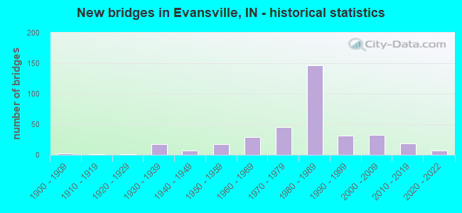
- New bridges - historical statistics
- 1Before 1900
- 21900-1909
- 11910-1919
- 11920-1929
- 171930-1939
- 71940-1949
- 171950-1959
- 291960-1969
- 451970-1979
- 1471980-1989
- 311990-1999
- 322000-2009
- 192010-2019
- 72020-2022
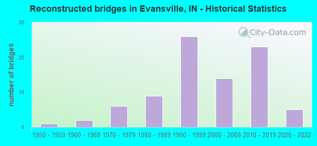
- Reconstructed bridges - Historical Statistics
- 11950-1959
- 21960-1969
- 61970-1979
- 91980-1989
- 261990-1999
- 142000-2009
- 232010-2019
- 52020-2022
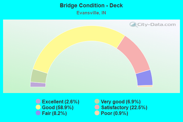
- Bridge Condition - Deck
- 2.6%Excellent
- 6.9%Very good
- 58.9%Good
- 22.5%Satisfactory
- 8.2%Fair
- 0.9%Poor
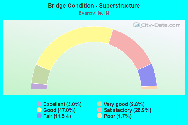
- Bridge Condition - Superstructure
- 3.0%Excellent
- 9.8%Very good
- 47.0%Good
- 26.9%Satisfactory
- 11.5%Fair
- 1.7%Poor
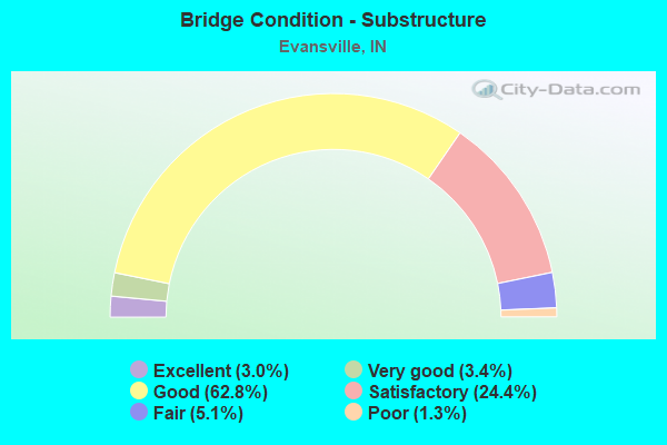
- Bridge Condition - Substructure
- 3.0%Excellent
- 3.4%Very good
- 62.8%Good
- 24.4%Satisfactory
- 5.1%Fair
- 1.3%Poor
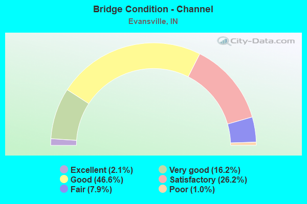
- Bridge Condition - Channel
- 2.1%Excellent
- 16.2%Very good
- 46.6%Good
- 26.2%Satisfactory
- 7.9%Fair
- 1.0%Poor
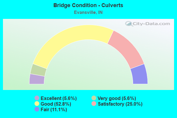
- Bridge Condition - Culverts
- 5.6%Excellent
- 5.6%Very good
- 52.8%Good
- 25.0%Satisfactory
- 11.1%Fair
Find on map >> Show street view
Structure Number: 1428, Location: 01.09 S SR 62 (Lat: 37.977100, Lng: -87.544050), Route carried "under" structure: State highway 62, Year Built: 1972, Structure Length: 0. m, Average Daily Traffic: 43,420 (year 2014), Truck Traffic: 11%, Features Intersected: SR 66/62 WB, Facility Carried by Structure: US 41 S
Minimum Vertical Clearance: 4.77m (15.65ft), Kilometerpoint: 14.597, Lanes on structure: 3, Lanes under structure: 4, Material/Design: Steel continuous, Design/Construction: Stringer/Multi-beam, Length of Maximum Span: 23.3m (76.4ft)
Find on map >> Show street view
Structure Number: 1428, Location: 01.09 S SR 62 (Lat: 37.976972, Lng: -87.544039), Route carried "under" structure: State highway 62, Year Built: 1972, Structure Length: 0. m, Average Daily Traffic: 43,420 (year 2014), Truck Traffic: 11%, Features Intersected: SR 66/62 EB, Facility Carried by Structure: US 41 SB
Minimum Vertical Clearance: 4.77m (15.65ft), Kilometerpoint: 14.597, Lanes on structure: 3, Lanes under structure: 4, Material/Design: Steel continuous, Design/Construction: Stringer/Multi-beam, Length of Maximum Span: 23.3m (76.4ft)
Find on map >> Show street view
Structure Number: 1429, Location: 00.46 N SR 62 (Lat: 37.999100, Lng: -87.537689), Route carried "under" structure: State highway 66, Year Built: 1972, Structure Length: 0. m, Average Daily Traffic: 41,044 (year 2004), Truck Traffic: 20%, Features Intersected: SR 66/E DIAMOND AVE, Facility Carried by Structure: US 41
Minimum Vertical Clearance: 4.50m (14.76ft), Kilometerpoint: 15.337, Lanes on structure: 5, Lanes under structure: 7, Material/Design: Steel continuous, Design/Construction: Stringer/Multi-beam, Length of Maximum Span: 27.9m (91.5ft)
Find on map >> Show street view
Structure Number: 21929, Location: 07.50 W US 41 (Lat: 37.967061, Lng: -87.676872), Route carried "under" structure: US 62, Year Built: 1994, Structure Length: 0. m, Average Daily Traffic: 16,696 (year 2016), Truck Traffic: 5%, Features Intersected: SR 62 WB, Facility Carried by Structure: UNIVERSITY PKWY
Minimum Vertical Clearance: 5.77m (18.93ft), Kilometerpoint: 2.575, Lanes on structure: 5, Lanes under structure: 2, Material/Design: Prestressed concrete continuous, Design/Construction: Box Beam or Girders - Single/Spread, Length of Maximum Span: 27.4m (89.9ft)
Find on map >> Show street view
Structure Number: 21929, Location: 07.50 W US 41 (Lat: 37.967061, Lng: -87.676872), Route carried "under" structure: State highway 62, Year Built: 1994, Structure Length: 0. m, Average Daily Traffic: 16,696 (year 2016), Truck Traffic: 5%, Features Intersected: SR 62 EB, Facility Carried by Structure: UNIVERSITY PKWY
Minimum Vertical Clearance: 5.77m (18.93ft), Kilometerpoint: 2.575, Lanes on structure: 5, Lanes under structure: 2, Material/Design: Prestressed concrete continuous, Design/Construction: Box Beam or Girders - Single/Spread, Length of Maximum Span: 27.4m (89.9ft)
Find on map >> Show street view
Structure Number: 2195, Location: 04.09 W US 41 (Lat: 37.977550, Lng: -87.618958), Route carried "under" structure: City street , Year Built: 1956, Structure Length: 0. m, Average Daily Traffic: 3,947 (year 2014), Features Intersected: TEKOPPEL AVE, Facility Carried by Structure: SR 62
Minimum Vertical Clearance: 5.46m (17.91ft), Kilometerpoint: 0.000, Lanes on structure: 4, Lanes under structure: 4, Material/Design: Concrete continuous, Design/Construction: Stringer/Multi-beam, Length of Maximum Span: 18.0m (59.1ft)
Find on map >> Show street view
Structure Number: 2196, Location: 03.60 W US 41 (Lat: 37.978200, Lng: -87.609731), Route carried "under" structure: State highway 62, Year Built: 1956, Structure Length: 0. m, Average Daily Traffic: 41,000 (year 2014), Truck Traffic: 5%, Features Intersected: BARKER AVE, Facility Carried by Structure: SR 66 WB
Minimum Vertical Clearance: 4.80m (15.75ft), Kilometerpoint: 8.851, Lanes on structure: 4, Lanes under structure: 3, Material/Design: Concrete continuous, Design/Construction: Frame, Length of Maximum Span: 15.4m (50.5ft)
Find on map >> Show street view
Structure Number: 2196, Location: 03.60 W US 41 (Lat: 37.978056, Lng: -87.609731), Route carried "under" structure: State highway 62, Year Built: 1956, Structure Length: 0. m, Average Daily Traffic: 41,000 (year 2014), Truck Traffic: 5%, Features Intersected: BARKER AVE, Facility Carried by Structure: SR 66 EB
Minimum Vertical Clearance: 4.80m (15.75ft), Kilometerpoint: 8.851, Lanes on structure: 4, Lanes under structure: 3, Material/Design: Concrete continuous, Design/Construction: Frame, Length of Maximum Span: 15.4m (50.5ft)
Find on map >> Show street view
Structure Number: 21971, Location: 02.47 W US 41 (Lat: 37.977881, Lng: -87.592125), Route carried "under" structure: City street , Year Built: 2000, Structure Length: 0. m, Average Daily Traffic: 118 (year 2004), Features Intersected: 9TH AVENUE, Facility Carried by Structure: SR 62
Minimum Vertical Clearance: 4.90m (16.08ft), Kilometerpoint: 0.000, Lanes on structure: 6, Lanes under structure: 2, Material/Design: Prestressed concrete, Design/Construction: Stringer/Multi-beam, Length of Maximum Span: 18.4m (60.4ft)
Find on map >> Show street view
Structure Number: 21972, Location: 02.45 W US 41 (Lat: 37.977881, Lng: -87.587844), Route carried "under" structure: ServiceCity street , Year Built: 2000, Structure Length: 0. m, Average Daily Traffic: 102 (year 2004), Truck Traffic: 50%, Features Intersected: ACCESS RD, Facility Carried by Structure: SR 62
Minimum Vertical Clearance: 6.61m (21.69ft), Kilometerpoint: 0.000, Lanes on structure: 6, Lanes under structure: 2, Material/Design: Prestressed concrete continuous, Design/Construction: Tee Beam, Length of Maximum Span: 39.5m (129.6ft)
Find on map >> Show street view
Structure Number: 21974, Location: 01.72 W US 41 (Lat: 37.977256, Lng: -87.575100), Route carried "under" structure: City street , Year Built: 1988, Structure Length: 0. m, Average Daily Traffic: 2,500 (year 2004), Truck Traffic: 10%, Features Intersected: SR 62 EB, Facility Carried by Structure: NW 4TH ST NB
Minimum Vertical Clearance: 6.15m (20.18ft), Kilometerpoint: 0.000, Lanes on structure: 3, Lanes under structure: 3, Material/Design: Steel continuous, Design/Construction: Stringer/Multi-beam, Length of Maximum Span: 32.6m (107.0ft)
Find on map >> Show street view
Structure Number: 21974, Location: 01.72 W US 41 (Lat: 37.977292, Lng: -87.575500), Route carried "under" structure: City street , Year Built: 1988, Structure Length: 0. m, Average Daily Traffic: 2,500 (year 2004), Truck Traffic: 10%, Features Intersected: SR 62 EB, Facility Carried by Structure: NW 3RD ST SB
Minimum Vertical Clearance: 6.15m (20.18ft), Kilometerpoint: 0.000, Lanes on structure: 3, Lanes under structure: 3, Material/Design: Steel continuous, Design/Construction: Stringer/Multi-beam, Length of Maximum Span: 32.6m (107.0ft)
Find on map >> Show street view
Structure Number: 21975, Location: 01.72 W US 41 (Lat: 37.977431, Lng: -87.575067), Route carried "under" structure: City street , Year Built: 1988, Structure Length: 0. m, Average Daily Traffic: 118 (year 2004), Truck Traffic: 2%, Features Intersected: SR 62 WB, Facility Carried by Structure: NW 3RD ST NB
Minimum Vertical Clearance: 5.26m (17.26ft), Kilometerpoint: 0.000, Lanes on structure: 4, Lanes under structure: 3, Material/Design: Steel continuous, Design/Construction: Stringer/Multi-beam, Length of Maximum Span: 32.6m (107.0ft)
Find on map >> Show street view
Structure Number: 21975, Location: 01.72 W US 41 (Lat: 37.977453, Lng: -87.575400), Route carried "under" structure: City street , Year Built: 1988, Structure Length: 0. m, Average Daily Traffic: 118 (year 2004), Truck Traffic: 2%, Features Intersected: SR 62 WB, Facility Carried by Structure: NW 3RD ST SB
Minimum Vertical Clearance: 5.26m (17.26ft), Kilometerpoint: 0.000, Lanes on structure: 4, Lanes under structure: 3, Material/Design: Steel continuous, Design/Construction: Stringer/Multi-beam, Length of Maximum Span: 32.6m (107.0ft)
Find on map >> Show street view
Structure Number: 21976, Location: 01.48 W US 41 (Lat: 37.977089, Lng: -87.570786), Route carried "under" structure: City street , Year Built: 1988, Structure Length: 0. m, Average Daily Traffic: 5,830 (year 2004), Truck Traffic: 2%, Features Intersected: ML KING - MARY STREET, Facility Carried by Structure: SR 62 EBL
Minimum Vertical Clearance: 4.93m (16.17ft), Kilometerpoint: 0.000, Lanes on structure: 4, Lanes under structure: 4, Material/Design: Prestressed concrete, Design/Construction: Stringer/Multi-beam, Length of Maximum Span: 21.8m (71.5ft)
Find on map >> Show street view
Structure Number: 21977, Location: 01.48 W US 41 (Lat: 37.977261, Lng: -87.570786), Route carried "under" structure: City street , Year Built: 1988, Structure Length: 0. m, Average Daily Traffic: 5,830 (year 2014), Truck Traffic: 2%, Features Intersected: ML KING - MARY ST, Facility Carried by Structure: SR 62 WB
Minimum Vertical Clearance: 4.62m (15.16ft), Kilometerpoint: 0.000, Lanes on structure: 3, Lanes under structure: 4, Material/Design: Prestressed concrete, Design/Construction: Stringer/Multi-beam, Length of Maximum Span: 21.8m (71.5ft)
Find on map >> Show street view
Structure Number: 21978, Location: 01.09 W US 41 (Lat: 37.976989, Lng: -87.564094), Route carried "under" structure: City street , Year Built: 1988, Structure Length: 0. m, Average Daily Traffic: 3,040 (year 2014), Features Intersected: MAIN ST, Facility Carried by Structure: SR 62 EB
Minimum Vertical Clearance: 4.57m (14.99ft), Kilometerpoint: 0.000, Lanes on structure: 3, Lanes under structure: 4, Material/Design: Prestressed concrete, Design/Construction: Stringer/Multi-beam, Length of Maximum Span: 22.9m (75.1ft)
Find on map >> Show street view
Structure Number: 21979, Location: 01.09 W US 41 (Lat: 37.977139, Lng: -87.564056), Route carried "under" structure: City street , Year Built: 1988, Structure Length: 0. m, Average Daily Traffic: 3,040 (year 2014), Features Intersected: MAIN STREET, Facility Carried by Structure: SR 62 WB
Minimum Vertical Clearance: 4.85m (15.91ft), Kilometerpoint: 0.000, Lanes on structure: 4, Lanes under structure: 4, Material/Design: Prestressed concrete, Design/Construction: Stringer/Multi-beam, Length of Maximum Span: 22.9m (75.1ft)
Find on map >> Show street view
Structure Number: 21981, Location: 00.94 W US 41 (Lat: 37.977039, Lng: -87.561272), Route carried "under" structure: City street , Year Built: 1988, Structure Length: 0. m, Average Daily Traffic: 118 (year 2004), Truck Traffic: 10%, Features Intersected: HEIDELBACH STREET, Facility Carried by Structure: SR 62 EB
Minimum Vertical Clearance: 6.15m (20.18ft), Kilometerpoint: 0.000, Lanes on structure: 3, Lanes under structure: 3, Material/Design: Prestressed concrete, Design/Construction: Stringer/Multi-beam, Length of Maximum Span: 21.8m (71.5ft)
Find on map >> Show street view
Structure Number: 21982, Location: 00.94 W US 41 (Lat: 37.977200, Lng: -87.561272), Route carried "under" structure: City street , Year Built: 1988, Structure Length: 0. m, Average Daily Traffic: 118 (year 2004), Truck Traffic: 10%, Features Intersected: HEIDELBACH STREET, Facility Carried by Structure: SR 62 WB
Minimum Vertical Clearance: 6.63m (21.75ft), Kilometerpoint: 0.000, Lanes on structure: 4, Lanes under structure: 3, Material/Design: Prestressed concrete, Design/Construction: Stringer/Multi-beam, Length of Maximum Span: 21.8m (71.5ft)
Find on map >> Show street view
Structure Number: 21983, Location: 00.94 W US 41 (Lat: 37.976831, Lng: -87.561286), Route carried "under" structure: City street , Year Built: 1988, Structure Length: 0. m, Average Daily Traffic: 118 (year 2004), Truck Traffic: 10%, Features Intersected: SR 62 EB ON RAMP, Facility Carried by Structure: HEIDELBACH STREET
Minimum Vertical Clearance: 5.13m (16.83ft), Kilometerpoint: 0.000, Lanes on structure: 1, Lanes under structure: 3, Material/Design: Prestressed concrete, Design/Construction: Stringer/Multi-beam, Length of Maximum Span: 22.1m (72.5ft)
Find on map >> Show street view
Structure Number: 21984, Location: 00.80 W US 41 (Lat: 37.976989, Lng: -87.558517), Route carried "under" structure: City street , Year Built: 1988, Structure Length: 0. m, Average Daily Traffic: 118 (year 2004), Truck Traffic: 10%, Features Intersected: SR 62 EB, Facility Carried by Structure: GOVERNOR ST
Minimum Vertical Clearance: 6.81m (22.34ft), Kilometerpoint: 0.000, Lanes on structure: 4, Lanes under structure: 2, Material/Design: Steel continuous, Design/Construction: Stringer/Multi-beam, Length of Maximum Span: 28.5m (93.5ft)
Find on map >> Show street view
Structure Number: 21985, Location: 00.80 W US 41 (Lat: 37.977150, Lng: -87.558503), Route carried "under" structure: City street , Year Built: 1988, Structure Length: 0. m, Average Daily Traffic: 118 (year 2004), Truck Traffic: 10%, Features Intersected: GOVERNOR ST, Facility Carried by Structure: SR 62 WB
Minimum Vertical Clearance: 6.81m (22.34ft), Kilometerpoint: 0.000, Lanes on structure: 3, Lanes under structure: 2, Material/Design: Steel continuous, Design/Construction: Stringer/Multi-beam, Length of Maximum Span: 28.4m (93.2ft)
Find on map >> Show street view
Structure Number: 21986, Location: 00.69 W US 41 (Lat: 37.976861, Lng: -87.556708), Route carried "under" structure: City street , Year Built: 1988, Structure Length: 0. m, Average Daily Traffic: 118 (year 2004), Truck Traffic: 10%, Features Intersected: GARVIN STREET, Facility Carried by Structure: SR 62 EB
Minimum Vertical Clearance: 5.66m (18.57ft), Kilometerpoint: 0.000, Lanes on structure: 4, Lanes under structure: 3, Material/Design: Prestressed concrete, Design/Construction: Stringer/Multi-beam, Length of Maximum Span: 18.7m (61.4ft)
Find on map >> Show street view
Structure Number: 21987, Location: 00.69 W US 41 (Lat: 37.977031, Lng: -87.556686), Route carried "under" structure: City street , Year Built: 1988, Structure Length: 0. m, Average Daily Traffic: 118 (year 2004), Truck Traffic: 5%, Features Intersected: GARVIN STREET, Facility Carried by Structure: SR 62 WB
Minimum Vertical Clearance: 6.25m (20.51ft), Kilometerpoint: 0.000, Lanes on structure: 3, Lanes under structure: 3, Material/Design: Prestressed concrete, Design/Construction: Stringer/Multi-beam, Length of Maximum Span: 18.7m (61.4ft)
Find on map >> Show street view
Structure Number: 23393, Location: 02.73 W US 41 (Lat: 38.003519, Lng: -87.588347), Route carried "under" structure: City street , Year Built: 1961, Structure Length: 0. m, Average Daily Traffic: 118 (year 2004), Truck Traffic: 12%, Features Intersected: GROVE AVENUE, Facility Carried by Structure: SR 66
Minimum Vertical Clearance: 5.82m (19.09ft), Kilometerpoint: 0.000, Lanes on structure: 4, Lanes under structure: 2, Material/Design: Prestressed concrete continuous, Design/Construction: Stringer/Multi-beam, Length of Maximum Span: 14.4m (47.2ft)
Find on map >> Show street view
Structure Number: 23398, Location: 00.12 W US 41 (Lat: 37.999139, Lng: -87.541175), Route carried "under" structure: State highway 66, Year Built: 1963, Structure Length: 0. m, Average Daily Traffic: 18,343 (year 2004), Truck Traffic: 5%, Features Intersected: SR 66 WB, Facility Carried by Structure: CSX RR
Minimum Vertical Clearance: 4.40m (14.44ft), Kilometerpoint: 15.144, Lanes under structure: 6, Material/Design: Prestressed concrete, Design/Construction: Box Beam or Girders - Multiple, Length of Maximum Span: 13.3m (43.6ft)
Find on map >> Show street view
Structure Number: 23398, Location: 00.12 W US 41 (Lat: 37.999139, Lng: -87.541175), Route carried "under" structure: State highway 66, Year Built: 1963, Structure Length: 0. m, Average Daily Traffic: 18,343 (year 2004), Truck Traffic: 5%, Features Intersected: SR 66 EB, Facility Carried by Structure: CSX RR
Minimum Vertical Clearance: 4.47m (14.67ft), Kilometerpoint: 15.144, Lanes under structure: 3, Material/Design: Prestressed concrete, Design/Construction: Box Beam or Girders - Multiple, Length of Maximum Span: 13.3m (43.6ft)
Find on map >> Show street view
Structure Number: 23401, Location: 00.76 E US 41 (Lat: 37.977011, Lng: -87.529350), Route carried "under" structure: City street , Year Built: 1988, Structure Length: 0. m, Average Daily Traffic: 118 (year 2004), Truck Traffic: 10%, Features Intersected: WEINBACH AVE, Facility Carried by Structure: SR 66 WBL
Minimum Vertical Clearance: 5.11m (16.77ft), Kilometerpoint: 0.000, Lanes on structure: 3, Lanes under structure: 4, Material/Design: Steel, Design/Construction: Stringer/Multi-beam, Length of Maximum Span: 31.1m (102.0ft)
Find on map >> Show street view
Structure Number: 23405, Location: 01.24 E US 41 (Lat: 37.976789, Lng: -87.520217), Route carried "under" structure: City street , Year Built: 1988, Structure Length: 0. m, Average Daily Traffic: 118 (year 2004), Truck Traffic: 10%, Features Intersected: BOEKE AVE, Facility Carried by Structure: SR 66 EBL
Minimum Vertical Clearance: 4.83m (15.85ft), Kilometerpoint: 0.000, Lanes on structure: 3, Lanes under structure: 6, Material/Design: Steel, Design/Construction: Stringer/Multi-beam, Length of Maximum Span: 40.2m (131.9ft)
Find on map >> Show street view
Structure Number: 23406, Location: 01.24 E US 41 (Lat: 37.976931, Lng: -87.520217), Route carried "under" structure: City street , Year Built: 1988, Structure Length: 0. m, Average Daily Traffic: 118 (year 2004), Truck Traffic: 10%, Features Intersected: BOEKE AVE, Facility Carried by Structure: SR 66 WBL
Minimum Vertical Clearance: 5.33m (17.49ft), Kilometerpoint: 0.000, Lanes on structure: 3, Lanes under structure: 6, Material/Design: Steel, Design/Construction: Stringer/Multi-beam, Length of Maximum Span: 40.2m (131.9ft)
Find on map >> Show street view
Structure Number: 23407, Location: 02.24 W I-164 (Lat: 37.976689, Lng: -87.492608), Route carried "under" structure: City street , Year Built: 2004, Structure Length: 0. m, Average Daily Traffic: 6,000 (year 2004), Truck Traffic: 12%, Features Intersected: GREEN RIVER ROAD & RAMPS, Facility Carried by Structure: SR 66 EB
Minimum Vertical Clearance: 5.21m (17.09ft), Kilometerpoint: 0.000, Lanes on structure: 3, Lanes under structure: 8, Material/Design: Prestressed concrete continuous, Design/Construction: Tee Beam, Length of Maximum Span: 41.5m (136.2ft)
Find on map >> Show street view
Structure Number: 23408, Location: 02.24 W I-164 (Lat: 37.976839, Lng: -87.492600), Route carried "under" structure: City street , Year Built: 2004, Structure Length: 0. m, Average Daily Traffic: 6,000 (year 2004), Truck Traffic: 10%, Features Intersected: GREEN RIVER ROAD & RAMPS, Facility Carried by Structure: SR 66 WB
Minimum Vertical Clearance: 5.21m (17.09ft), Kilometerpoint: 0.000, Lanes on structure: 3, Lanes under structure: 8, Material/Design: Prestressed concrete continuous, Design/Construction: Tee Beam, Length of Maximum Span: 41.5m (136.2ft)
Find on map >> Show street view
Structure Number: 7, Location: 00.26 W US 41 (Lat: 37.941719, Lng: -87.548211), Route carried "under" structure: Ramp City street , Year Built: 1988, Structure Length: 0. m, Average Daily Traffic: 118 (year 2004), Truck Traffic: 29%, Features Intersected: S KENTUCKY AVE, Facility Carried by Structure: I-69CD NB/VETERANS
Minimum Vertical Clearance: 5.08m (16.67ft), Kilometerpoint: 0.000, Lanes on structure: 1, Lanes under structure: 2, Material/Design: Prestressed concrete continuous, Design/Construction: Stringer/Multi-beam, Length of Maximum Span: 17.4m (57.1ft)
Find on map >> Show street view
Structure Number: 7001, Location: 00.26 W US 41 (Lat: 37.942189, Lng: -87.548217), Route carried "under" structure: Ramp City street , Year Built: 1988, Structure Length: 0. m, Average Daily Traffic: 812 (year 2014), Truck Traffic: 29%, Features Intersected: SOUTH KENTUCKY AVENUE, Facility Carried by Structure: I-69 CDSB
Minimum Vertical Clearance: 5.08m (16.67ft), Kilometerpoint: 0.000, Lanes on structure: 1, Lanes under structure: 1, Material/Design: Prestressed concrete continuous, Design/Construction: Stringer/Multi-beam, Length of Maximum Span: 17.4m (57.1ft)
Find on map >> Show street view
Structure Number: 7002, Location: 00.26 W US 41 (Lat: 37.941861, Lng: -87.548211), Route carried "under" structure: Ramp City street , Year Built: 1988, Structure Length: 0. m, Average Daily Traffic: 118 (year 2004), Truck Traffic: 29%, Features Intersected: SOUTH KENTUCKY AVENUE, Facility Carried by Structure: i-69 NB/VETERANS
Minimum Vertical Clearance: 5.21m (17.09ft), Kilometerpoint: 0.000, Lanes on structure: 2, Lanes under structure: 2, Material/Design: Prestressed concrete continuous, Design/Construction: Stringer/Multi-beam, Length of Maximum Span: 17.4m (57.1ft)
Find on map >> Show street view
Structure Number: 7003, Location: 00.26 W US 41 (Lat: 37.942061, Lng: -87.548217), Route carried "under" structure: Ramp City street , Year Built: 1988, Structure Length: 0. m, Average Daily Traffic: 118 (year 2004), Truck Traffic: 29%, Features Intersected: SOUTH KENTUCKY AVENUE, Facility Carried by Structure: I-69 WB/VETERANS
Minimum Vertical Clearance: 5.26m (17.26ft), Kilometerpoint: 0.000, Lanes on structure: 2, Lanes under structure: 1, Material/Design: Prestressed concrete continuous, Design/Construction: Stringer/Multi-beam, Length of Maximum Span: 17.4m (57.1ft)
Find on map >> Show street view
Structure Number: 7006, Location: 05.56 W SR 662 (Lat: 37.939950, Lng: -87.543983), Route carried "under" structure: US 41, Year Built: 1988, Structure Length: 0. m, Average Daily Traffic: 18,910 (year 2004), Truck Traffic: 29%, Features Intersected: US 41 SB, Facility Carried by Structure: I-69 CDEB
Minimum Vertical Clearance: 6.10m (20.01ft), Kilometerpoint: 1.931, Lanes on structure: 2, Lanes under structure: 3, Material/Design: Steel continuous, Design/Construction: Stringer/Multi-beam, Length of Maximum Span: 40.8m (133.9ft)
Find on map >> Show street view
Structure Number: 7006, Location: 05.56 W SR 662 (Lat: 37.939950, Lng: -87.543983), Route carried "under" structure: US 41, Year Built: 1988, Structure Length: 0. m, Average Daily Traffic: 18,910 (year 2004), Truck Traffic: 29%, Features Intersected: US 41 NB & CD, Facility Carried by Structure: I-69 CDEB
Minimum Vertical Clearance: 6.10m (20.01ft), Kilometerpoint: 1.931, Lanes on structure: 2, Lanes under structure: 3, Material/Design: Steel continuous, Design/Construction: Stringer/Multi-beam, Length of Maximum Span: 40.8m (133.9ft)
Find on map >> Show street view
Structure Number: 7007, Location: 05.56 W SR 662 (Lat: 37.940389, Lng: -87.543717), Route carried "under" structure: US 41, Year Built: 1988, Structure Length: 0. m, Average Daily Traffic: 18,910 (year 2004), Truck Traffic: 29%, Features Intersected: US 41 SB, Facility Carried by Structure: I-69 CDWB
Minimum Vertical Clearance: 6.76m (22.18ft), Kilometerpoint: 1.979, Lanes on structure: 3, Lanes under structure: 3, Material/Design: Steel continuous, Design/Construction: Stringer/Multi-beam, Length of Maximum Span: 40.8m (133.9ft)
Find on map >> Show street view
Structure Number: 7007, Location: 05.56 W SR 662 (Lat: 37.940389, Lng: -87.543717), Route carried "under" structure: US 41, Year Built: 1988, Structure Length: 0. m, Average Daily Traffic: 18,910 (year 2004), Truck Traffic: 29%, Features Intersected: US 41 NB & CD, Facility Carried by Structure: I-69 CDWB
Minimum Vertical Clearance: 6.76m (22.18ft), Kilometerpoint: 1.979, Lanes on structure: 3, Lanes under structure: 3, Material/Design: Steel continuous, Design/Construction: Stringer/Multi-beam, Length of Maximum Span: 40.8m (133.9ft)
Find on map >> Show street view
Structure Number: 7008, Location: 05.56 W SR 662 (Lat: 37.940039, Lng: -87.543861), Route carried "under" structure: US 41, Year Built: 1988, Structure Length: 0. m, Average Daily Traffic: 18,910 (year 2004), Truck Traffic: 29%, Features Intersected: US 41 SB, Facility Carried by Structure: I-69 EB
Minimum Vertical Clearance: 6.27m (20.57ft), Kilometerpoint: 1.947, Lanes on structure: 2, Lanes under structure: 3, Material/Design: Steel continuous, Design/Construction: Stringer/Multi-beam, Length of Maximum Span: 40.8m (133.9ft)
Find on map >> Show street view
Structure Number: 7008, Location: 05.56 W SR 662 (Lat: 37.940039, Lng: -87.543861), Route carried "under" structure: US 41, Year Built: 1988, Structure Length: 0. m, Average Daily Traffic: 18,910 (year 2004), Truck Traffic: 29%, Features Intersected: US 41 NB & CD, Facility Carried by Structure: I-69 EB
Minimum Vertical Clearance: 6.27m (20.57ft), Kilometerpoint: 1.947, Lanes on structure: 2, Lanes under structure: 3, Material/Design: Steel continuous, Design/Construction: Stringer/Multi-beam, Length of Maximum Span: 40.8m (133.9ft)
Find on map >> Show street view
Structure Number: 7009, Location: 05.56 W SR 662 (Lat: 37.940250, Lng: -87.543808), Route carried "under" structure: US 41, Year Built: 1988, Structure Length: 0. m, Average Daily Traffic: 18,910 (year 2004), Truck Traffic: 29%, Features Intersected: US 41 SB, Facility Carried by Structure: I-69 WB
Minimum Vertical Clearance: 6.58m (21.59ft), Kilometerpoint: 1.963, Lanes on structure: 2, Lanes under structure: 3, Material/Design: Steel continuous, Design/Construction: Stringer/Multi-beam, Length of Maximum Span: 40.8m (133.9ft)
Find on map >> Show street view
Structure Number: 7009, Location: 05.56 W SR 662 (Lat: 37.940250, Lng: -87.543808), Route carried "under" structure: US 41, Year Built: 1988, Structure Length: 0. m, Average Daily Traffic: 18,910 (year 2004), Truck Traffic: 29%, Features Intersected: US 41 NB & CD, Facility Carried by Structure: I-69 WB
Minimum Vertical Clearance: 6.58m (21.59ft), Kilometerpoint: 1.963, Lanes on structure: 2, Lanes under structure: 3, Material/Design: Steel continuous, Design/Construction: Stringer/Multi-beam, Length of Maximum Span: 40.8m (133.9ft)
Find on map >> Show street view
Structure Number: 701, Location: 00.82 E US 41 (Lat: 37.935661, Lng: -87.529908), Route carried "under" structure: City street , Year Built: 1989, Structure Length: 0. m, Average Daily Traffic: 118 (year 2004), Truck Traffic: 11%, Features Intersected: WEINBACH AVENUE, Facility Carried by Structure: I-69 NB
Minimum Vertical Clearance: 6.71m (22.01ft), Kilometerpoint: 0.000, Lanes on structure: 2, Lanes under structure: 2, Material/Design: Prestressed concrete continuous, Design/Construction: Stringer/Multi-beam, Length of Maximum Span: 16.2m (53.1ft)
Find on map >> Show street view
Structure Number: 7011, Location: 00.82 E US 41 (Lat: 37.935839, Lng: -87.529908), Route carried "under" structure: City street , Year Built: 1989, Structure Length: 0. m, Average Daily Traffic: 118 (year 2004), Truck Traffic: 11%, Features Intersected: WEINBACH AVENUE, Facility Carried by Structure: I-69 WB
Minimum Vertical Clearance: 4.70m (15.42ft), Kilometerpoint: 0.000, Lanes on structure: 2, Lanes under structure: 2, Material/Design: Prestressed concrete continuous, Design/Construction: Stringer/Multi-beam, Length of Maximum Span: 16.2m (53.1ft)
Find on map >> Show street view
Structure Number: 7012, Location: 02.71 W SR 662 (Lat: 37.939400, Lng: -87.492942), Route carried "under" structure: City street , Year Built: 1988, Structure Length: 0. m, Average Daily Traffic: 6,555 (year 2004), Truck Traffic: 10%, Features Intersected: GREEN RIVER ROAD, Facility Carried by Structure: I-69 NB
Minimum Vertical Clearance: 5.05m (16.57ft), Kilometerpoint: 0.000, Lanes on structure: 3, Lanes under structure: 2, Material/Design: Prestressed concrete continuous, Design/Construction: Stringer/Multi-beam, Length of Maximum Span: 15.1m (49.5ft)
Find on map >> Show street view
Structure Number: 7013, Location: 02.71 W SR 662 (Lat: 37.939619, Lng: -87.492958), Route carried "under" structure: City street , Year Built: 1988, Structure Length: 0. m, Average Daily Traffic: 6,555 (year 2004), Truck Traffic: 10%, Features Intersected: GREEN RIVER ROAD, Facility Carried by Structure: I-69 SB
Minimum Vertical Clearance: 5.61m (18.41ft), Kilometerpoint: 0.000, Lanes on structure: 2, Lanes under structure: 2, Material/Design: Prestressed concrete continuous, Design/Construction: Stringer/Multi-beam, Length of Maximum Span: 15.1m (49.5ft)
Find on map >> Show street view
Structure Number: 7014, Location: 01.39 W SR 662 (Lat: 37.947511, Lng: -87.470900), Route carried "under" structure: City street , Year Built: 1988, Structure Length: 0. m, Average Daily Traffic: 118 (year 2004), Truck Traffic: 5%, Features Intersected: POLLACK AVENUE, Facility Carried by Structure: I-69 NB
Minimum Vertical Clearance: 4.55m (14.93ft), Kilometerpoint: 0.000, Lanes on structure: 2, Lanes under structure: 2, Material/Design: Prestressed concrete continuous, Design/Construction: Stringer/Multi-beam, Length of Maximum Span: 19.1m (62.7ft)
Find on map >> Show street view
Structure Number: 7015, Location: 01.39 W SR 662 (Lat: 37.947589, Lng: -87.471200), Route carried "under" structure: City street , Year Built: 1988, Structure Length: 0. m, Average Daily Traffic: 118 (year 2004), Truck Traffic: 5%, Features Intersected: POLLACK AVENUE, Facility Carried by Structure: I-69 SB
Minimum Vertical Clearance: 4.55m (14.93ft), Kilometerpoint: 0.000, Lanes on structure: 2, Lanes under structure: 2, Material/Design: Prestressed concrete continuous, Design/Construction: Stringer/Multi-beam, Length of Maximum Span: 19.1m (62.7ft)
Find on map >> Show street view
Structure Number: 7016, Location: 00.78 W SR 662 (Lat: 37.949511, Lng: -87.459892), Route carried "under" structure: City street , Year Built: 1988, Structure Length: 0. m, Average Daily Traffic: 118 (year 2004), Truck Traffic: 5%, Features Intersected: FUQUAY ROAD, Facility Carried by Structure: I-69 NB
Minimum Vertical Clearance: 4.44m (14.57ft), Kilometerpoint: 0.000, Lanes on structure: 2, Lanes under structure: 2, Material/Design: Prestressed concrete continuous, Design/Construction: Stringer/Multi-beam, Length of Maximum Span: 16.5m (54.1ft)
Find on map >> Show street view
Structure Number: 7017, Location: 00.78 W SR 662 (Lat: 37.949650, Lng: -87.459908), Route carried "under" structure: City street , Year Built: 1988, Structure Length: 0. m, Average Daily Traffic: 118 (year 2004), Truck Traffic: 5%, Features Intersected: FUQUAY ROAD, Facility Carried by Structure: I-69 SB
Minimum Vertical Clearance: 4.72m (15.49ft), Kilometerpoint: 0.000, Lanes on structure: 2, Lanes under structure: 2, Material/Design: Prestressed concrete continuous, Design/Construction: Stringer/Multi-beam, Length of Maximum Span: 16.5m (54.1ft)
Find on map >> Show street view
Structure Number: 7018, Location: 01.50 S SR 66 (Lat: 37.955061, Lng: -87.448386), Route carried "under" structure: State highway 662, Year Built: 1989, Structure Length: 0. m, Average Daily Traffic: 18,636 (year 2004), Truck Traffic: 10%, Features Intersected: SR 662/COVERT AVENUE, Facility Carried by Structure: I-69 NB
Minimum Vertical Clearance: 5.87m (19.26ft), Kilometerpoint: 0.209, Lanes on structure: 2, Lanes under structure: 4, Material/Design: Prestressed concrete continuous, Design/Construction: Stringer/Multi-beam, Length of Maximum Span: 21.0m (68.9ft)
Find on map >> Show street view
Structure Number: 7019, Location: 01.50 S SR 66 (Lat: 37.955061, Lng: -87.448747), Route carried "under" structure: State highway 662, Year Built: 1989, Structure Length: 0. m, Average Daily Traffic: 18,636 (year 2004), Truck Traffic: 10%, Features Intersected: SR 662, Facility Carried by Structure: I-69 SB
Minimum Vertical Clearance: 4.57m (14.99ft), Kilometerpoint: 0.177, Lanes on structure: 3, Lanes under structure: 4, Material/Design: Prestressed concrete continuous, Design/Construction: Stringer/Multi-beam, Length of Maximum Span: 21.1m (69.2ft)
Find on map >> Show street view
Structure Number: 702, Location: 00.52 S SR 66 (Lat: 37.969481, Lng: -87.448775), Route carried "under" structure: City street , Year Built: 1989, Structure Length: 0. m, Average Daily Traffic: 118 (year 2004), Truck Traffic: 5%, Features Intersected: OUTER LINCOLN AVENUE, Facility Carried by Structure: I-69 NB
Minimum Vertical Clearance: 4.47m (14.67ft), Kilometerpoint: 0.000, Lanes on structure: 2, Lanes under structure: 2, Material/Design: Prestressed concrete continuous, Design/Construction: Stringer/Multi-beam, Length of Maximum Span: 13.7m (44.9ft)
Find on map >> Show street view
Structure Number: 7021, Location: 00.52 S SR 66 (Lat: 37.969469, Lng: -87.449089), Route carried "under" structure: City street , Year Built: 1989, Structure Length: 0. m, Average Daily Traffic: 118 (year 2004), Truck Traffic: 5%, Features Intersected: OUTER LINCOLN AVENUE, Facility Carried by Structure: I-69 SB
Minimum Vertical Clearance: 4.93m (16.17ft), Kilometerpoint: 0.000, Lanes on structure: 2, Lanes under structure: 2, Material/Design: Prestressed concrete continuous, Design/Construction: Stringer/Multi-beam, Length of Maximum Span: 13.7m (44.9ft)
Find on map >> Show street view
Structure Number: 7022, Location: 01.55 S SR 62 (Lat: 37.976831, Lng: -87.451631), Route carried "under" structure: State highway 66, Year Built: 1989, Structure Length: 0. m, Average Daily Traffic: 19,108 (year 2006), Truck Traffic: 10%, Features Intersected: SR 66 EB, Facility Carried by Structure: I-69 NB
Minimum Vertical Clearance: 5.18m (16.99ft), Kilometerpoint: 25.943, Lanes on structure: 3, Lanes under structure: 4, Material/Design: Steel continuous, Design/Construction: Stringer/Multi-beam, Length of Maximum Span: 39.6m (129.9ft)
Find on map >> Show street view
Structure Number: 7022, Location: 01.55 S SR 62 (Lat: 37.976831, Lng: -87.451631), Route carried "under" structure: State highway 66, Year Built: 1989, Structure Length: 0. m, Average Daily Traffic: 19,108 (year 2006), Truck Traffic: 10%, Features Intersected: SR 66 WB, Facility Carried by Structure: I-69 NB
Minimum Vertical Clearance: 5.18m (16.99ft), Kilometerpoint: 25.943, Lanes on structure: 3, Lanes under structure: 4, Material/Design: Steel continuous, Design/Construction: Stringer/Multi-beam, Length of Maximum Span: 39.6m (129.9ft)
Find on map >> Show street view
Structure Number: 7023, Location: 01.55 S SR 62 (Lat: 37.976839, Lng: -87.452042), Route carried "under" structure: State highway 66, Year Built: 1989, Structure Length: 0. m, Average Daily Traffic: 19,108 (year 2006), Truck Traffic: 10%, Features Intersected: SR 66 EB, Facility Carried by Structure: I-69 SB
Minimum Vertical Clearance: 5.13m (16.83ft), Kilometerpoint: 25.927, Lanes on structure: 3, Lanes under structure: 4, Material/Design: Steel continuous, Design/Construction: Stringer/Multi-beam, Length of Maximum Span: 39.6m (129.9ft)
Find on map >> Show street view
Structure Number: 7023, Location: 01.55 S SR 62 (Lat: 37.976839, Lng: -87.452042), Route carried "under" structure: State highway 66, Year Built: 1989, Structure Length: 0. m, Average Daily Traffic: 19,108 (year 2006), Truck Traffic: 10%, Features Intersected: SR 66 WB, Facility Carried by Structure: I-69 SB
Minimum Vertical Clearance: 5.13m (16.83ft), Kilometerpoint: 25.927, Lanes on structure: 3, Lanes under structure: 4, Material/Design: Steel continuous, Design/Construction: Stringer/Multi-beam, Length of Maximum Span: 39.6m (129.9ft)
Find on map >> Show street view
Structure Number: 7025, Location: 00.41 S SR 62 (Lat: 37.991261, Lng: -87.462906), Route carried "under" structure: Interstate 69, Year Built: 1987, Structure Length: 0. m, Average Daily Traffic: 12,580 (year 2004), Truck Traffic: 20%, Features Intersected: I-69 SB, Facility Carried by Structure: OAK GROVE ROAD
Minimum Vertical Clearance: 5.11m (16.77ft), Kilometerpoint: 13.197, Lanes on structure: 2, Lanes under structure: 4, Material/Design: Steel continuous, Design/Construction: Stringer/Multi-beam, Length of Maximum Span: 40.5m (132.9ft)
Find on map >> Show street view
Structure Number: 7025, Location: 00.41 S SR 62 (Lat: 37.991261, Lng: -87.462906), Route carried "under" structure: Interstate 69, Year Built: 1987, Structure Length: 0. m, Average Daily Traffic: 12,580 (year 2004), Truck Traffic: 20%, Features Intersected: I-69 NB, Facility Carried by Structure: OAK GROVE ROAD
Minimum Vertical Clearance: 5.11m (16.77ft), Kilometerpoint: 13.197, Lanes on structure: 2, Lanes under structure: 4, Material/Design: Steel continuous, Design/Construction: Stringer/Multi-beam, Length of Maximum Span: 40.5m (132.9ft)
Find on map >> Show street view
Structure Number: 7026, Location: 01.55 N SR 66 (Lat: 37.996619, Lng: -87.465692), Route carried "under" structure: State highway 62, Year Built: 1987, Structure Length: 0. m, Average Daily Traffic: 9,805 (year 2004), Truck Traffic: 20%, Features Intersected: SR 62 EB, Facility Carried by Structure: I-69 NB
Minimum Vertical Clearance: 6.10m (20.01ft), Kilometerpoint: 22.820, Lanes on structure: 3, Lanes under structure: 2, Material/Design: Steel continuous, Design/Construction: Stringer/Multi-beam, Length of Maximum Span: 39.3m (128.9ft)
Find on map >> Show street view
Structure Number: 7026, Location: 01.55 N SR 66 (Lat: 37.996619, Lng: -87.465692), Route carried "under" structure: State highway 62, Year Built: 1987, Structure Length: 0. m, Average Daily Traffic: 9,805 (year 2004), Truck Traffic: 20%, Features Intersected: SR 62 WB, Facility Carried by Structure: I-69 NB
Minimum Vertical Clearance: 6.10m (20.01ft), Kilometerpoint: 22.820, Lanes on structure: 3, Lanes under structure: 2, Material/Design: Steel continuous, Design/Construction: Stringer/Multi-beam, Length of Maximum Span: 39.3m (128.9ft)
Find on map >> Show street view
Structure Number: 7027, Location: 01.55 N SR 66 (Lat: 37.996600, Lng: -87.466033), Route carried "under" structure: State highway 62, Year Built: 1987, Structure Length: 0. m, Average Daily Traffic: 9,805 (year 2004), Truck Traffic: 20%, Features Intersected: SR 62 EB, Facility Carried by Structure: I-69 SB
Minimum Vertical Clearance: 6.58m (21.59ft), Kilometerpoint: 22.804, Lanes on structure: 3, Lanes under structure: 2, Material/Design: Steel continuous, Design/Construction: Stringer/Multi-beam, Length of Maximum Span: 39.3m (128.9ft)
Find on map >> Show street view
Structure Number: 7027, Location: 01.55 N SR 66 (Lat: 37.996600, Lng: -87.466033), Route carried "under" structure: State highway 62, Year Built: 1987, Structure Length: 0. m, Average Daily Traffic: 9,805 (year 2004), Truck Traffic: 20%, Features Intersected: SR 62 WB, Facility Carried by Structure: I-69 SB
Minimum Vertical Clearance: 6.58m (21.59ft), Kilometerpoint: 22.804, Lanes on structure: 3, Lanes under structure: 2, Material/Design: Steel continuous, Design/Construction: Stringer/Multi-beam, Length of Maximum Span: 39.3m (128.9ft)
Find on map >> Show street view
Structure Number: 7028, Location: 00.55 N SR 62 (Lat: 38.004481, Lng: -87.467467), Route carried "under" structure: Interstate 69, Year Built: 1988, Structure Length: 0. m, Average Daily Traffic: 14,821 (year 2004), Truck Traffic: 20%, Features Intersected: I-69 SB, Facility Carried by Structure: OLD BOONVILLE ROAD
Minimum Vertical Clearance: 5.08m (16.67ft), Kilometerpoint: 14.742, Lanes on structure: 2, Lanes under structure: 4, Material/Design: Steel continuous, Design/Construction: Stringer/Multi-beam, Length of Maximum Span: 32.2m (105.6ft)
Find on map >> Show street view
Structure Number: 7028, Location: 00.55 N SR 62 (Lat: 38.004481, Lng: -87.467467), Route carried "under" structure: Interstate 69, Year Built: 1988, Structure Length: 0. m, Average Daily Traffic: 14,821 (year 2004), Truck Traffic: 20%, Features Intersected: I-69 NB, Facility Carried by Structure: OLD BOONVILLE ROAD
Minimum Vertical Clearance: 5.08m (16.67ft), Kilometerpoint: 14.742, Lanes on structure: 2, Lanes under structure: 4, Material/Design: Steel continuous, Design/Construction: Stringer/Multi-beam, Length of Maximum Span: 32.2m (105.6ft)
Find on map >> Show street view
Structure Number: 70285, Location: 01.14 N SR 62 (Lat: 38.012500, Lng: -87.469078), Route carried "under" structure: Interstate 69, Year Built: 2002, Structure Length: 0. m, Average Daily Traffic: 12,620 (year 2014), Truck Traffic: 15%, Features Intersected: I-69 NB, Facility Carried by Structure: LYNCH ROAD EB
Minimum Vertical Clearance: 5.03m (16.50ft), Kilometerpoint: 15.691, Lanes on structure: 3, Lanes under structure: 3, Material/Design: Steel continuous, Design/Construction: Stringer/Multi-beam, Length of Maximum Span: 37.2m (122.0ft)
Find on map >> Show street view
Structure Number: 70285, Location: 01.14 N SR 62 (Lat: 38.012500, Lng: -87.469078), Route carried "under" structure: Interstate 69, Year Built: 2002, Structure Length: 0. m, Average Daily Traffic: 12,620 (year 2014), Truck Traffic: 15%, Features Intersected: I-69 SB, Facility Carried by Structure: LYNCH ROAD EB
Minimum Vertical Clearance: 5.03m (16.50ft), Kilometerpoint: 15.691, Lanes on structure: 3, Lanes under structure: 3, Material/Design: Steel continuous, Design/Construction: Stringer/Multi-beam, Length of Maximum Span: 37.2m (122.0ft)
Find on map >> Show street view
Structure Number: 70286, Location: 01.14 N SR 62 (Lat: 38.012650, Lng: -87.469125), Route carried "under" structure: Interstate 69, Year Built: 2002, Structure Length: 0. m, Average Daily Traffic: 18,910 (year 2004), Truck Traffic: 10%, Features Intersected: I-69 NB, Facility Carried by Structure: LYNCH ROAD WB
Minimum Vertical Clearance: 5.03m (16.50ft), Kilometerpoint: 15.707, Lanes on structure: 2, Lanes under structure: 6, Material/Design: Steel continuous, Design/Construction: Stringer/Multi-beam, Length of Maximum Span: 37.2m (122.0ft)
Find on map >> Show street view
Structure Number: 70286, Location: 01.14 N SR 62 (Lat: 38.012650, Lng: -87.469125), Route carried "under" structure: Interstate 69, Year Built: 2002, Structure Length: 0. m, Average Daily Traffic: 18,910 (year 2004), Truck Traffic: 10%, Features Intersected: I-69 SB, Facility Carried by Structure: LYNCH ROAD WB
Minimum Vertical Clearance: 5.03m (16.50ft), Kilometerpoint: 15.707, Lanes on structure: 2, Lanes under structure: 6, Material/Design: Steel continuous, Design/Construction: Stringer/Multi-beam, Length of Maximum Span: 37.2m (122.0ft)
Find on map >> Show street view
Structure Number: 7031, Location: 02.11 N SR 62 (Lat: 38.027469, Lng: -87.471878), Route carried "under" structure: City street , Year Built: 1987, Structure Length: 0. m, Average Daily Traffic: 118 (year 2004), Truck Traffic: 20%, Features Intersected: OLMSTEAD ROAD, Facility Carried by Structure: I-69 NB
Minimum Vertical Clearance: 4.52m (14.83ft), Kilometerpoint: 0.000, Lanes on structure: 2, Lanes under structure: 2, Material/Design: Steel continuous, Design/Construction: Stringer/Multi-beam, Length of Maximum Span: 14.6m (47.9ft)
Find on map >> Show street view
Structure Number: 7032, Location: 02.11 N SR 62 (Lat: 38.027461, Lng: -87.472183), Route carried "under" structure: City street , Year Built: 1987, Structure Length: 0. m, Average Daily Traffic: 118 (year 2004), Truck Traffic: 20%, Features Intersected: OLMSTEAD ROAD, Facility Carried by Structure: I-69 SB
Minimum Vertical Clearance: 4.52m (14.83ft), Kilometerpoint: 0.000, Lanes on structure: 2, Lanes under structure: 2, Material/Design: Steel continuous, Design/Construction: Stringer/Multi-beam, Length of Maximum Span: 14.6m (47.9ft)
Find on map >> Show street view
Structure Number: 7035, Location: 03.60 N SR 62 (Lat: 38.049431, Lng: -87.474350), Route carried "under" structure: City street , Year Built: 1987, Structure Length: 0. m, Average Daily Traffic: 118 (year 2004), Truck Traffic: 20%, Features Intersected: MILLERSBURG ROAD, Facility Carried by Structure: I-69 NB
Minimum Vertical Clearance: 4.65m (15.26ft), Kilometerpoint: 0.000, Lanes on structure: 2, Lanes under structure: 2, Material/Design: Prestressed concrete continuous, Design/Construction: Box Beam or Girders - Single/Spread, Length of Maximum Span: 14.0m (45.9ft)
Find on map >> Show street view
Structure Number: 7036, Location: 03.60 N SR 62 (Lat: 38.049419, Lng: -87.474639), Route carried "under" structure: City street , Year Built: 1987, Structure Length: 0. m, Average Daily Traffic: 118 (year 2004), Truck Traffic: 20%, Features Intersected: MILLERSBURG ROAD, Facility Carried by Structure: I-69 SB
Minimum Vertical Clearance: 4.65m (15.26ft), Kilometerpoint: 0.000, Lanes on structure: 2, Lanes under structure: 2, Material/Design: Prestressed concrete continuous, Design/Construction: Box Beam or Girders - Single/Spread, Length of Maximum Span: 14.0m (45.9ft)
Find on map >> Show street view
Structure Number: 7042, Location: 05.53 S I-64 (Lat: 38.089361, Lng: -87.476608), Route carried "under" structure: Interstate 69, Year Built: 1987, Structure Length: 0. m, Average Daily Traffic: 12,020 (year 2004), Truck Traffic: 20%, Features Intersected: I-69 NB, Facility Carried by Structure: BOONVILLE-N/HARM
Minimum Vertical Clearance: 5.03m (16.50ft), Kilometerpoint: 24.011, Lanes on structure: 2, Lanes under structure: 4, Material/Design: Prestressed concrete continuous, Design/Construction: Stringer/Multi-beam, Length of Maximum Span: 27.6m (90.6ft)
Find on map >> Show street view
Structure Number: 7042, Location: 05.53 S I-64 (Lat: 38.089361, Lng: -87.476608), Route carried "under" structure: Interstate 69, Year Built: 1987, Structure Length: 0. m, Average Daily Traffic: 12,020 (year 2004), Truck Traffic: 20%, Features Intersected: I-69 SB, Facility Carried by Structure: BOONVILLE-N/HARM
Minimum Vertical Clearance: 5.03m (16.50ft), Kilometerpoint: 24.011, Lanes on structure: 2, Lanes under structure: 4, Material/Design: Prestressed concrete continuous, Design/Construction: Stringer/Multi-beam, Length of Maximum Span: 27.6m (90.6ft)
Find on map >> Show street view
Structure Number: 7052, Location: 00.29 S I-64 (Lat: 38.165419, Lng: -87.471778), Route carried "under" structure: Interstate 69, Year Built: 1989, Structure Length: 0. m, Average Daily Traffic: 8,155 (year 2014), Truck Traffic: 15%, Features Intersected: I-69 SB, Facility Carried by Structure: CR 900N
Minimum Vertical Clearance: 5.44m (17.85ft), Kilometerpoint: 32.444, Lanes on structure: 2, Lanes under structure: 3, Material/Design: Steel continuous, Design/Construction: Stringer/Multi-beam, Length of Maximum Span: 43.0m (141.1ft)
Find on map >> Show street view
Structure Number: 7052, Location: 00.29 S I-64 (Lat: 38.165419, Lng: -87.471778), Route carried "under" structure: Interstate 69, Year Built: 1989, Structure Length: 0. m, Average Daily Traffic: 8,155 (year 2014), Truck Traffic: 15%, Features Intersected: I-69 NB, Facility Carried by Structure: CR 900N
Minimum Vertical Clearance: 5.44m (17.85ft), Kilometerpoint: 32.444, Lanes on structure: 2, Lanes under structure: 3, Material/Design: Steel continuous, Design/Construction: Stringer/Multi-beam, Length of Maximum Span: 43.0m (141.1ft)
Find on map >> Show street view
Structure Number: 80016, Location: 2.05 W US 41 (Lat: 37.977739, Lng: -87.581253), Route carried "under" structure: City street , Year Built: 2011, Structure Length: 0. m, Average Daily Traffic: 8,782 (year 2008), Truck Traffic: 10%, Features Intersected: FULTON AVENUE, Facility Carried by Structure: SR 62
Minimum Vertical Clearance: 5.08m (16.67ft), Kilometerpoint: 0.000, Lanes on structure: 4, Lanes under structure: 5, Material/Design: Prestressed concrete, Design/Construction: Tee Beam, Length of Maximum Span: 34.6m (113.5ft)
Find on map >> Show street view
Structure Number: 8200002, Location: 00.20 W OF 7TH AVE (Lat: 37.984481, Lng: -87.589919), Route carried "under" structure: City street , Year Built: 1955, Structure Length: 0. m, Average Daily Traffic: 1,476 (year 2011), Truck Traffic: 5%, Features Intersected: 9 TH AVE, Facility Carried by Structure: COLUMBIA/DELAWARE
Minimum Vertical Clearance: 4.47m (14.67ft), Kilometerpoint: 0.000, Lanes on structure: 4, Lanes under structure: 2, Material/Design: Steel continuous, Design/Construction: Stringer/Multi-beam, Length of Maximum Span: 21.0m (68.9ft)