Bridge Statistics for Everett, Washington (WA)
Condition, Traffic, Stress, Structural Evaluation, Project Costs
- National Bridge Inventory (NBI) Statistics
- 126Number of bridges
- 5,469ft / 1,667mTotal length
- $1,001,210,000Total costs
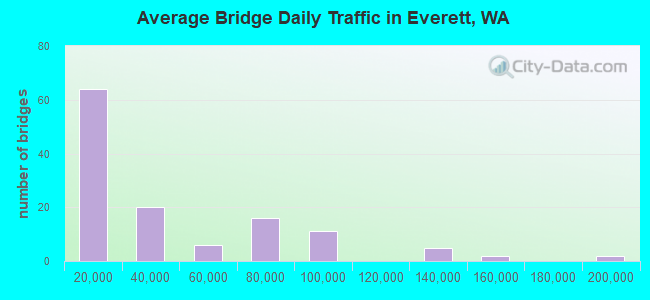
- 4,805,444Total average daily traffic
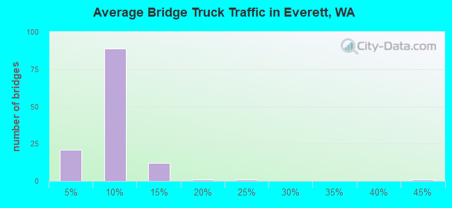
- 288,242Total average daily truck traffic
- National Bridge Inventory (NBI) Registered Bridges for Everett
- No street view available for this location
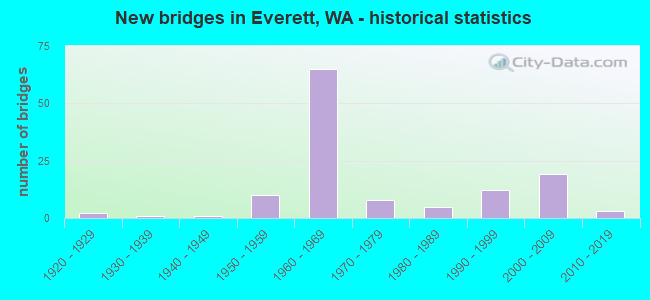
- New bridges - historical statistics
- 21920-1929
- 11930-1939
- 11940-1949
- 101950-1959
- 651960-1969
- 81970-1979
- 51980-1989
- 121990-1999
- 192000-2009
- 32010-2019
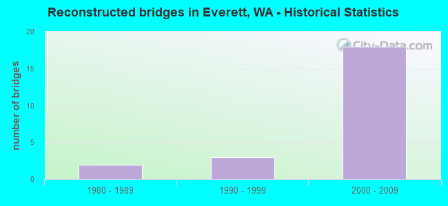
- Reconstructed bridges - Historical Statistics
- 21980-1989
- 31990-1999
- 182000-2009
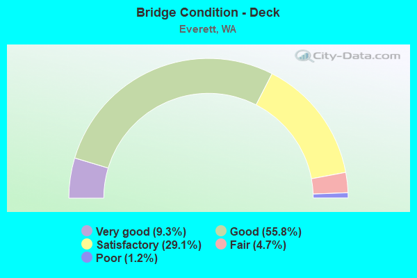
- Bridge Condition - Deck
- 9.3%Very good
- 55.8%Good
- 29.1%Satisfactory
- 4.7%Fair
- 1.2%Poor
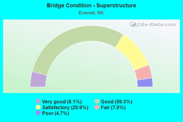
- Bridge Condition - Superstructure
- 8.1%Very good
- 59.3%Good
- 20.9%Satisfactory
- 7.0%Fair
- 4.7%Poor
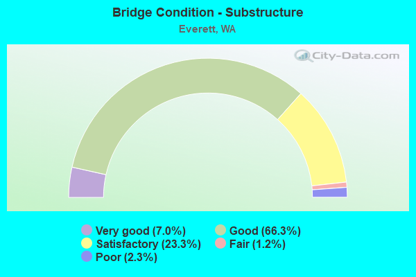
- Bridge Condition - Substructure
- 7.0%Very good
- 66.3%Good
- 23.3%Satisfactory
- 1.2%Fair
- 2.3%Poor
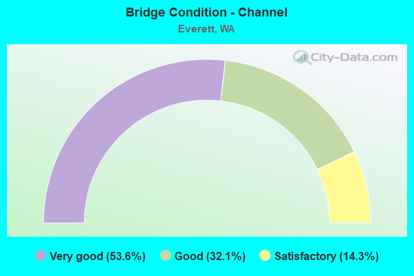
- Bridge Condition - Channel
- 53.6%Very good
- 32.1%Good
- 14.3%Satisfactory
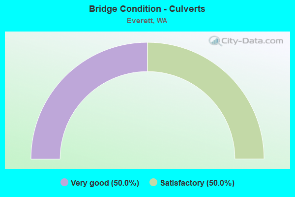
- Bridge Condition - Culverts
- 50.0%Very good
- 50.0%Satisfactory
Find on map >> Show street view
Structure Number: 85593, Location: 0.07 W JCT SHORE AVE (Lat: 47.951031, Lng: -122.286289), Route carried "on" structure: City street 420, Year Built: 1946, Status: Posted for load, Structure Length: 10.85m (35.60ft), Average Daily Traffic: 6,000 (year 2016), Truck Traffic: 5%, Average Future Daily Traffic: 10,000 (year 2038), Design Load: H 15, Features Intersected: EDGEWATER CREEK, Facility Carried by Structure: MUKILTEO BLVD
Minimum Vertical Clearance: 30+ m (98+ ft), Kilometerpoint: 0.016, Lanes on structure: 2, Base Highway Network: Yes, Owner: City or Municipal Highway Agency, Approaching Roadway Width: 9.1m (29.9ft), Material/Design: Concrete continuous, Design/Construction: Girder and Floorbeam System, Number Of Spans In Main Unit: 5, Length of Maximum Span: 27.7m (90.9ft), Curb or Sidewalk Widths: Left: 1.3m (4.3ft), Right: 1.3m (4.3ft), Curb-To-Curb Width: 7.9m (25.9ft), Out-to-Out Width: 11.2m (36.7ft)
Condition: Deck: Poor, Superstructure: Fair, Substructure: Satisfactory, Channel: Very good, Operating Rating: 14.6 metric tons, Method Used To Determine Operating Rating: Load Factor (LF) rating reported by rating factor (RF) method using MS18 loading, Inventory Rating: 8.7 metric tons, Method Used To Determine Inventory Rating: Load Factor (LF) rating reported by rating factor (RF) method using MS18 loading, Structural Evaluation: High priority of replacement, Deck Geometry: High priority of corrective action, Waterway Adequacy: Equal to present desirable criteria, Approach Roadway Alignment: Equal to present minimum criteria, Bridge Posting: Required (Relationship of Operating Rating to Maximum Legal Load: > 39.9% below), Length Of Structure Improvement: 11.16m (36.61ft), Designated Inspection Frequency: Every 24 months, Inspection Date: October 2020, Bridge Improvement Cost: $5,563,000, Roadway Improvement Cost: $1,113,000, Total Project Cost: $11,126,000 ( Estimate for 2014), Deck Structure Type: Concrete Cast-file-Place, Wearing Surface/Protective System: Wearing Surface: Bituminous
Find on map >> Show street view
Structure Number: 85605, Location: 0.1 W JCT GLENWOOD AVE (Lat: 47.956800, Lng: -122.250200), Route carried "on" structure: City street 420, Year Built: 1979, Status: Open, Structure Length: 9.24m (30.31ft), Average Daily Traffic: 6,200 (year 2016), Truck Traffic: 5%, Average Future Daily Traffic: 10,000 (year 2038), Design Load: HS 20, Features Intersected: GLENWOOD CREEK, Facility Carried by Structure: MUKILTEO BLVD
Minimum Vertical Clearance: 30+ m (98+ ft), Kilometerpoint: 3.058, Lanes on structure: 2, Base Highway Network: Yes, Owner: City or Municipal Highway Agency, Approaching Roadway Width: 12.2m (40.0ft), Material/Design: Prestressed concrete continuous, Design/Construction: Stringer/Multi-beam, Number Of Spans In Main Unit: 3, Length of Maximum Span: 33.5m (109.9ft), Curb or Sidewalk Widths: Left: 1.5m (4.9ft), Right: 1.5m (4.9ft), Curb-To-Curb Width: 12.2m (40.0ft), Out-to-Out Width: 15.5m (50.9ft)
Condition: Deck: Satisfactory, Superstructure: Good, Substructure: Good, Channel: Very good, Operating Rating: 79.8 metric tons, Method Used To Determine Operating Rating: Load Factor (LF), Inventory Rating: 48.1 metric tons, Method Used To Determine Inventory Rating: Load Factor (LF), Structural Evaluation: Better than present minimum criteria, Deck Geometry: Somewhat better than minimum adequacy, Waterway Adequacy: Equal to present desirable criteria, Approach Roadway Alignment: Equal to present desirable criteria, Length Of Structure Improvement: 9.24m (30.31ft), Designated Inspection Frequency: Every 24 months, Inspection Date: October 2020, Bridge Improvement Cost: $2,545,000, Roadway Improvement Cost: $509,000, Total Project Cost: $5,090,000 ( Estimate for 2014), Deck Structure Type: Concrete Cast-file-Place, Wearing Surface/Protective System: Wearing Surface: Monolithic Concrete
Find on map >> Show street view
Structure Number: 85606, Location: 0.15 W JCT HARBOR LANE (Lat: 47.957008, Lng: -122.259456), Route carried "on" structure: City street 42007, Year Built: 1931, Year Reconstructed: 1980, Status: Posted for load, Structure Length: 11.70m (38.39ft), Average Daily Traffic: 6,123 (year 2015), Truck Traffic: 5%, Average Future Daily Traffic: 10,000 (year 2036), Design Load: HS 20, Features Intersected: MERRILL & RING CREEK, Facility Carried by Structure: MULIKLTEO BLVD
Minimum Vertical Clearance: 30+ m (98+ ft), Kilometerpoint: 16.093, Lanes on structure: 2, Base Highway Network: Yes, Owner: City or Municipal Highway Agency, Approaching Roadway Width: 11.9m (39.0ft), Material/Design: Steel continuous, Design/Construction: Truss - Deck, Number Of Spans In Main Unit: 3, Number Of Approach Spans: 2, Length of Maximum Span: 54.9m (180.1ft), Curb or Sidewalk Widths: Left: 1.5m (4.9ft), Right: 1.5m (4.9ft), Curb-To-Curb Width: 10.4m (34.1ft), Out-to-Out Width: 14.3m (46.9ft)
Condition: Deck: Fair, Superstructure: Poor, Substructure: Satisfactory, Channel: Very good, Operating Rating: 22.7 metric tons, Method Used To Determine Operating Rating: Load Factor (LF) rating reported by rating factor (RF) method using MS18 loading, Inventory Rating: 13.6 metric tons, Method Used To Determine Inventory Rating: Load Factor (LF) rating reported by rating factor (RF) method using MS18 loading, Structural Evaluation: High priority of replacement, Deck Geometry: Meets minimum limits, Waterway Adequacy: Equal to present desirable criteria, Approach Roadway Alignment: Equal to present desirable criteria, Bridge Posting: Required (Relationship of Operating Rating to Maximum Legal Load: > 39.9% below), Length Of Structure Improvement: 12.01m (39.40ft), Designated Inspection Frequency: Every 24 months, Other Special Inspection Frequency: Every 24 months, Inspection Date: September 2021, Other Special Inspection Date: September 2021, Bridge Improvement Cost: $5,989,000, Roadway Improvement Cost: $1,198,000, Total Project Cost: $11,978,000 ( Estimate for 2014), Deck Structure Type: Concrete Cast-file-Place, Wearing Surface/Protective System: Wearing Surface: Monolithic Concrete
Find on map >> Show street view
Structure Number: 85735, Location: 0.1 N OF HEWITT AVE (Lat: 47.979908, Lng: -122.203000), Route carried "on" structure: City street 42017, Year Built: 1989, Status: Open, Structure Length: 2.35m (7.71ft), Average Daily Traffic: 400 (year 2017), Truck Traffic: 5%, Average Future Daily Traffic: 1,000 (year 2042), Design Load: HS 20, Features Intersected: BURLINGTON NORTHERN RR, Facility Carried by Structure: LOMBARD AVENUE
Minimum Vertical Clearance: 30+ m (98+ ft), Kilometerpoint: 0.001, Lanes on structure: 2, Owner: City or Municipal Highway Agency, Approaching Roadway Width: 12.2m (40.0ft), Material/Design: Prestressed concrete, Design/Construction: Tee Beam, Number Of Spans In Main Unit: 1, Number Of Approach Spans: 2, Length of Maximum Span: 16.8m (55.1ft), Curb or Sidewalk Widths: Left: 3.0m (9.8ft), Right: 3.0m (9.8ft), Curb-To-Curb Width: 12.2m (40.0ft), Out-to-Out Width: 18.8m (61.7ft)
Condition: Deck: Good, Superstructure: Good, Substructure: Satisfactory, Operating Rating: 47.2 metric tons, Method Used To Determine Operating Rating: Load Factor (LF), Inventory Rating: 28.1 metric tons, Method Used To Determine Inventory Rating: Load Factor (LF), Structural Evaluation: Equal to present minimum criteria, Deck Geometry: Superior to present desirable criteria, Underclear: Somewhat better than minimum adequacy, Approach Roadway Alignment: Equal to present desirable criteria, Length Of Structure Improvement: 2.65m (8.69ft), Designated Inspection Frequency: Every 24 months, Inspection Date: April 2021, Bridge Improvement Cost: $1,322,000, Roadway Improvement Cost: $264,000, Total Project Cost: $2,645,000 ( Estimate for 2014), Deck Structure Type: Other, Wearing Surface/Protective System: Wearing Surface: Bituminous, Deck Protection: Epoxy Coated Reinforcing
Find on map >> Show street view
Structure Number: 85736, Location: 0.1MI N. OF HEWITT (Lat: 47.979722, Lng: -122.204444), Route carried "on" structure: City street 42020, Year Built: 1989, Status: Open, Structure Length: 2.90m (9.51ft), Average Daily Traffic: 4,700 (year 2017), Truck Traffic: 5%, Average Future Daily Traffic: 6,000 (year 2040), Design Load: HS 20, Features Intersected: BURLINGTON NORTHERN RR, Facility Carried by Structure: OAKES AVENUE
Minimum Vertical Clearance: 30+ m (98+ ft), Kilometerpoint: 0.001, Lanes on structure: 2, Owner: City or Municipal Highway Agency, Approaching Roadway Width: 14.6m (47.9ft), Material/Design: Prestressed concrete, Design/Construction: Tee Beam, Number Of Spans In Main Unit: 1, Number Of Approach Spans: 2, Length of Maximum Span: 23.2m (76.1ft), Curb or Sidewalk Widths: Left: 4.7m (15.4ft), Right: 3.0m (9.8ft), Curb-To-Curb Width: 14.6m (47.9ft), Out-to-Out Width: 22.8m (74.8ft)
Condition: Deck: Satisfactory, Superstructure: Satisfactory, Substructure: Good, Operating Rating: 52.2 metric tons, Method Used To Determine Operating Rating: Load Factor (LF) rating reported by rating factor (RF) method using MS18 loading, Inventory Rating: 31.4 metric tons, Method Used To Determine Inventory Rating: Load Factor (LF) rating reported by rating factor (RF) method using MS18 loading, Structural Evaluation: Equal to present minimum criteria, Deck Geometry: Superior to present desirable criteria, Underclear: Somewhat better than minimum adequacy, Approach Roadway Alignment: Equal to present desirable criteria, Length Of Structure Improvement: 3.20m (10.50ft), Designated Inspection Frequency: Every 24 months, Inspection Date: April 2021, Bridge Improvement Cost: $1,596,000, Roadway Improvement Cost: $319,000, Total Project Cost: $3,192,000 ( Estimate for 2014), Deck Structure Type: Other, Wearing Surface/Protective System: Wearing Surface: Bituminous, Deck Protection: Epoxy Coated Reinforcing
Find on map >> Show street view
Structure Number: 85737, Location: 0.1 MI E OF BROADWAY (Lat: 47.979183, Lng: -122.199581), Route carried "on" structure: City street 420, Year Built: 1989, Status: Open, Structure Length: 5.09m (16.70ft), Average Daily Traffic: 9,600 (year 2018), Truck Traffic: 2%, Average Future Daily Traffic: 15,650 (year 2040), Design Load: HS 20, Features Intersected: BURLINGTON NORTHERN RR, Facility Carried by Structure: HEWITT AVENUE
Minimum Vertical Clearance: 30+ m (98+ ft), Kilometerpoint: 1.287, Lanes on structure: 4, Base Highway Network: Yes, Owner: City or Municipal Highway Agency, Approaching Roadway Width: 21.0m (68.9ft), Skew: 5 degrees, Material/Design: Prestressed concrete, Design/Construction: Tee Beam, Number Of Spans In Main Unit: 2, Number Of Approach Spans: 2, Length of Maximum Span: 21.9m (71.9ft), Curb or Sidewalk Widths: Left: 3.0m (9.8ft), Right: 3.0m (9.8ft), Curb-To-Curb Width: 15.2m (49.9ft), Out-to-Out Width: 21.9m (71.9ft)
Condition: Deck: Good, Superstructure: Satisfactory, Substructure: Satisfactory, Operating Rating: 42.4 metric tons, Method Used To Determine Operating Rating: Load Factor (LF) rating reported by rating factor (RF) method using MS18 loading, Inventory Rating: 25.3 metric tons, Method Used To Determine Inventory Rating: Load Factor (LF) rating reported by rating factor (RF) method using MS18 loading, Structural Evaluation: Equal to present minimum criteria, Deck Geometry: High priority of corrective action, Underclear: Equal to present minimum criteria, Approach Roadway Alignment: Equal to present desirable criteria, Length Of Structure Improvement: 5.09m (16.70ft), Designated Inspection Frequency: Every 24 months, Inspection Date: October 2020, Bridge Improvement Cost: $2,372,000, Roadway Improvement Cost: $474,000, Total Project Cost: $4,743,000 ( Estimate for 2014), Deck Structure Type: Other, Wearing Surface/Protective System: Wearing Surface: Bituminous
Find on map >> Show street view
Structure Number: 86054, Location: 2.5 N EVERETT AVE (Lat: 48.016389, Lng: -122.207222), Route carried "on" structure: State highway 529, Year Built: 1993, Status: Open, Structure Length: 24.32m (79.79ft), Average Daily Traffic: 5,673 (year 2019), Truck Traffic: 3%, Average Future Daily Traffic: 8,214 (year 2039), Design Load: HS 20+Mod, Features Intersected: BNRR
Minimum Vertical Clearance: 30+ m (98+ ft), Kilometerpoint: 6.325, Lanes on structure: 2, Base Highway Network: Yes, Owner: State Highway Agency, Approaching Roadway Width: 9.8m (32.2ft), Material/Design: Prestressed concrete continuous, Design/Construction: Stringer/Multi-beam, Number Of Spans In Main Unit: 9, Length of Maximum Span: 32.0m (105.0ft), Curb-To-Curb Width: 9.8m (32.2ft), Out-to-Out Width: 10.7m (35.1ft)
Condition: Deck: Good, Superstructure: Satisfactory, Substructure: Good, Operating Rating: 74.4 metric tons, Method Used To Determine Operating Rating: Load Factor (LF), Inventory Rating: 44.4 metric tons, Method Used To Determine Inventory Rating: Load Factor (LF), Structural Evaluation: Equal to present minimum criteria, Deck Geometry: Meets minimum limits, Underclear: Equal to present minimum criteria, Approach Roadway Alignment: Equal to present minimum criteria, Length Of Structure Improvement: 24.32m (79.79ft), Designated Inspection Frequency: Every 48 months, Inspection Date: August 2018, Bridge Improvement Cost: $5,426,000, Roadway Improvement Cost: $1,085,000, Total Project Cost: $10,853,000 ( Estimate for 2014), Deck Structure Type: Concrete Cast-file-Place, Wearing Surface/Protective System: Wearing Surface: Monolithic Concrete, Deck Protection: Epoxy Coated Reinforcing
Find on map >> Show street view
Structure Number: 86055, Location: 2.5 N EVERETT AVE (Lat: 48.016667, Lng: -122.206667), Route carried "on" structure: State highway 529, Year Built: 1993, Status: Open, Structure Length: 25.82m (84.71ft), Average Daily Traffic: 5,673 (year 2019), Truck Traffic: 3%, Average Future Daily Traffic: 8,214 (year 2039), Design Load: HS 20+Mod, Features Intersected: BNRR
Minimum Vertical Clearance: 30+ m (98+ ft), Kilometerpoint: 6.325, Lanes on structure: 2, Base Highway Network: Yes, Owner: State Highway Agency, Approaching Roadway Width: 7.9m (25.9ft), Material/Design: Prestressed concrete continuous, Design/Construction: Stringer/Multi-beam, Number Of Spans In Main Unit: 10, Length of Maximum Span: 29.9m (98.1ft), Curb or Sidewalk Widths: Left: 3.0m (9.8ft), Right: 0.0m, Curb-To-Curb Width: 7.9m (25.9ft), Out-to-Out Width: 12.3m (40.4ft)
Condition: Deck: Good, Superstructure: Good, Substructure: Good, Operating Rating: 73.5 metric tons, Method Used To Determine Operating Rating: Load Factor (LF), Inventory Rating: 43.5 metric tons, Method Used To Determine Inventory Rating: Load Factor (LF), Structural Evaluation: Better than present minimum criteria, Deck Geometry: High priority of replacement, Underclear: Somewhat better than minimum adequacy, Approach Roadway Alignment: Equal to present desirable criteria, Length Of Structure Improvement: 25.82m (84.71ft), Designated Inspection Frequency: Every 48 months, Inspection Date: August 2018, Bridge Improvement Cost: $4,743,000, Roadway Improvement Cost: $949,000, Total Project Cost: $9,486,000 ( Estimate for 2014), Deck Structure Type: Concrete Cast-file-Place, Wearing Surface/Protective System: Wearing Surface: Monolithic Concrete, Deck Protection: Epoxy Coated Reinforcing
Find on map >> Show street view
Structure Number: 86225, Location: South of 56th (Lat: 47.946944, Lng: -122.266389), Route carried "on" structure: City street 420, Year Built: 1993, Status: Open, Structure Length: 0.94m (3.08ft), Average Daily Traffic: 300 (year 2016), Truck Traffic: 5%, Average Future Daily Traffic: 500 (year 2038), Design Load: HL 93, Features Intersected: POWDER MILL GULCH, Facility Carried by Structure: 25TH AVE WEST
Minimum Vertical Clearance: 30+ m (98+ ft), Kilometerpoint: 0.001, Lanes on structure: 2, Owner: City or Municipal Highway Agency, Approaching Roadway Width: 11.0m (36.1ft), Skew: 3 degrees, Material/Design: Steel, Design/Construction: Culvert, Number Of Spans In Main Unit: 1, Length of Maximum Span: 9.4m (30.8ft), Curb or Sidewalk Widths: Left: 1.7m (5.6ft), Right: 1.7m (5.6ft), Curb-To-Curb Width: 11.0m (36.1ft), Out-to-Out Width: 14.3m (46.9ft)
Condition: Channel: Satisfactory, Culverts: Satisfactory, Operating Rating: 89.8 metric tons, Method Used To Determine Operating Rating: Load and Resistance Factor (LRFR), Inventory Rating: 89.8 metric tons, Method Used To Determine Inventory Rating: Load and Resistance Factor (LRFR), Structural Evaluation: Equal to present minimum criteria, Deck Geometry: Equal to present desirable criteria, Waterway Adequacy: Equal to present desirable criteria, Approach Roadway Alignment: Equal to present desirable criteria, Length Of Structure Improvement: 1.25m (4.10ft), Designated Inspection Frequency: Every 24 months, Inspection Date: November 2020, Bridge Improvement Cost: $623,000, Roadway Improvement Cost: $125,000, Total Project Cost: $1,246,000 ( Estimate for 2014)
Find on map >> Show street view
Structure Number: 87269, Location: Pacific Ave 0.25 Mi E I5 (Lat: 47.976708, Lng: -122.199539), Route carried "on" structure: City street 420, Year Built: 2002, Status: Open, Structure Length: 22.86m (75.00ft), Average Daily Traffic: 15,300 (year 2016), Truck Traffic: 7%, Average Future Daily Traffic: 20,000 (year 2040), Design Load: HL 93, Features Intersected: BNSF RR, Smith Street, Facility Carried by Structure: Pacific Avenue
Minimum Vertical Clearance: 30+ m (98+ ft), Kilometerpoint: 0.402, Lanes on structure: 4, Lanes under structure: 2, Base Highway Network: Yes, Owner: City or Municipal Highway Agency, Approaching Roadway Width: 18.9m (62.0ft), Skew: 1 degrees, Material/Design: Prestressed concrete, Design/Construction: Box Beam or Girders - Single/Spread, Number Of Spans In Main Unit: 8, Length of Maximum Span: 31.7m (104.0ft), Curb or Sidewalk Widths: Left: 2.1m (6.9ft), Right: 2.1m (6.9ft), Curb-To-Curb Width: 18.9m (62.0ft), Out-to-Out Width: 23.8m (78.1ft)
Condition: Deck: Satisfactory, Superstructure: Good, Substructure: Good, Operating Rating: 58.0 metric tons, Method Used To Determine Operating Rating: Load and Resistance Factor (LRFR), Inventory Rating: 35.4 metric tons, Method Used To Determine Inventory Rating: Load and Resistance Factor (LRFR), Structural Evaluation: Better than present minimum criteria, Deck Geometry: Equal to present minimum criteria, Underclear: Superior to present desirable criteria, Approach Roadway Alignment: Equal to present desirable criteria, Length Of Structure Improvement: 23.16m (75.98ft), Designated Inspection Frequency: Every 24 months, Inspection Date: December 2020, Bridge Improvement Cost: $18,848,000, Roadway Improvement Cost: $3,770,000, Total Project Cost: $37,696,000 ( Estimate for 2014), Deck Structure Type: Concrete Cast-file-Place, Wearing Surface/Protective System: Wearing Surface: Monolithic Concrete, Deck Protection: Epoxy Coated Reinforcing
Find on map >> Show street view
Structure Number: 8727, Location: Inter Smith Ave & Pacific (Lat: 47.976050, Lng: -122.198472), Route carried "on" structure: City street 420, Year Built: 2002, Status: Open, Structure Length: 6.31m (20.70ft), Average Daily Traffic: 10,100 (year 2016), Truck Traffic: 7%, Average Future Daily Traffic: 15,000 (year 2040), Design Load: HL 93, Features Intersected: Pacific Avenue, Facility Carried by Structure: Smith Avenue
Minimum Vertical Clearance: 30+ m (98+ ft), Kilometerpoint: 0.001, Lanes on structure: 3, Owner: City or Municipal Highway Agency, Approaching Roadway Width: 14.6m (47.9ft), Material/Design: Prestressed concrete, Design/Construction: Box Beam or Girders - Single/Spread, Number Of Spans In Main Unit: 2, Length of Maximum Span: 31.4m (103.0ft), Curb or Sidewalk Widths: Left: 2.1m (6.9ft), Right: 2.1m (6.9ft), Curb-To-Curb Width: 14.6m (47.9ft), Out-to-Out Width: 19.5m (64.0ft)
Condition: Deck: Good, Superstructure: Very good, Substructure: Good, Operating Rating: 68.0 metric tons, Method Used To Determine Operating Rating: Load and Resistance Factor (LRFR), Inventory Rating: 40.8 metric tons, Method Used To Determine Inventory Rating: Load and Resistance Factor (LRFR), Structural Evaluation: Better than present minimum criteria, Deck Geometry: Somewhat better than minimum adequacy, Approach Roadway Alignment: Equal to present desirable criteria, Length Of Structure Improvement: 6.61m (21.69ft), Designated Inspection Frequency: Every 24 months, Inspection Date: November 2020, Bridge Improvement Cost: $4,340,000, Roadway Improvement Cost: $868,000, Total Project Cost: $8,680,000 ( Estimate for 2014), Deck Structure Type: Concrete Cast-file-Place, Wearing Surface/Protective System: Wearing Surface: Monolithic Concrete, Deck Protection: Epoxy Coated Reinforcing
Find on map >> Show street view
Structure Number: 87271, Location: Inter Terminal & Everett (Lat: 47.981825, Lng: -122.215631), Route carried "on" structure: Business City street 420, Year Built: 2003, Status: Open, Structure Length: 5.67m (18.60ft), Average Daily Traffic: 650 (year 2016), Truck Traffic: 20%, Average Future Daily Traffic: 1,200 (year 2040), Design Load: HS 25 or greater, Features Intersected: BNSF RR, Facility Carried by Structure: Everett Avenue
Minimum Vertical Clearance: 30+ m (98+ ft), Kilometerpoint: 0.001, Lanes on structure: 3, Owner: City or Municipal Highway Agency, Approaching Roadway Width: 12.8m (42.0ft), Skew: 4 degrees, Material/Design: Prestressed concrete, Design/Construction: Box Beam or Girders - Multiple, Number Of Spans In Main Unit: 2, Length of Maximum Span: 30.5m (100.1ft), Curb or Sidewalk Widths: Left: 3.2m (10.5ft), Right: 0.0m, Curb-To-Curb Width: 12.8m (42.0ft), Out-to-Out Width: 16.9m (55.4ft)
Condition: Deck: Good, Superstructure: Good, Substructure: Good, Operating Rating: 66.2 metric tons, Method Used To Determine Operating Rating: Load and Resistance Factor (LRFR), Inventory Rating: 39.9 metric tons, Method Used To Determine Inventory Rating: Load and Resistance Factor (LRFR), Structural Evaluation: Better than present minimum criteria, Deck Geometry: Meets minimum limits, Underclear: Equal to present minimum criteria, Approach Roadway Alignment: Equal to present minimum criteria, Length Of Structure Improvement: 5.97m (19.59ft), Designated Inspection Frequency: Every 24 months, Inspection Date: November 2020, Bridge Improvement Cost: $3,920,000, Roadway Improvement Cost: $784,000, Total Project Cost: $7,840,000 ( Estimate for 2014), Deck Structure Type: Concrete Cast-file-Place, Wearing Surface/Protective System: Wearing Surface: Monolithic Concrete, Deck Protection: Epoxy Coated Reinforcing
Find on map >> Show street view
Structure Number: 87686, Location: 0.01 Mi East Jct I-5 (Lat: 47.964061, Lng: -122.196806), Route carried "on" structure: City street 420, Year Built: 2006, Status: Open, Structure Length: 1.68m (5.51ft), Average Daily Traffic: 500 (year 2016), Truck Traffic: 10%, Average Future Daily Traffic: 1,500 (year 2040), Design Load: HS 25 or greater, Features Intersected: Smith Avenue, Facility Carried by Structure: 41st St.
Minimum Vertical Clearance: 30+ m (98+ ft), Kilometerpoint: 0.001, Lanes on structure: 5, Owner: City or Municipal Highway Agency, Approaching Roadway Width: 20.7m (67.9ft), Skew: 1 degrees, Material/Design: Prestressed concrete, Design/Construction: Channel Beam, Number Of Spans In Main Unit: 1, Length of Maximum Span: 15.5m (50.9ft), Curb or Sidewalk Widths: Left: 2.0m (6.6ft), Right: 2.0m (6.6ft), Curb-To-Curb Width: 20.8m (68.2ft), Out-to-Out Width: 25.0m (82.0ft)
Condition: Deck: Very good, Superstructure: Very good, Substructure: Good, Operating Rating: 71.7 metric tons, Method Used To Determine Operating Rating: Load and Resistance Factor (LRFR), Inventory Rating: 42.6 metric tons, Method Used To Determine Inventory Rating: Load and Resistance Factor (LRFR), Structural Evaluation: Better than present minimum criteria, Deck Geometry: Somewhat better than minimum adequacy, Approach Roadway Alignment: Equal to present desirable criteria, Designated Inspection Frequency: Every 24 months, Inspection Date: November 2020, Deck Structure Type: Other, Wearing Surface/Protective System: Wearing Surface: Bituminous
Find on map >> Show street view
Structure Number: 87687, Location: 0.1 E Jct I-5 (Lat: 47.963925, Lng: -122.195231), Route carried "on" structure: City street 420, Year Built: 2006, Status: Open, Structure Length: 8.05m (26.41ft), Average Daily Traffic: 320 (year 2016), Truck Traffic: 10%, Average Future Daily Traffic: 1,200 (year 2040), Design Load: HS 25 or greater, Features Intersected: BNSF RR & Maple St, Facility Carried by Structure: 41st St.
Minimum Vertical Clearance: 30+ m (98+ ft), Kilometerpoint: 0.001, Lanes on structure: 4, Owner: City or Municipal Highway Agency, Approaching Roadway Width: 17.1m (56.1ft), Skew: 2 degrees, Material/Design: Prestressed concrete, Design/Construction: Stringer/Multi-beam, Number Of Spans In Main Unit: 3, Number Of Approach Spans: 2, Length of Maximum Span: 32.6m (107.0ft), Curb or Sidewalk Widths: Left: 2.0m (6.6ft), Right: 2.0m (6.6ft), Curb-To-Curb Width: 17.1m (56.1ft), Out-to-Out Width: 21.6m (70.9ft)
Condition: Deck: Good, Superstructure: Good, Substructure: Good, Operating Rating: 89.8 metric tons, Method Used To Determine Operating Rating: Load and Resistance Factor (LRFR), Inventory Rating: 64.4 metric tons, Method Used To Determine Inventory Rating: Load and Resistance Factor (LRFR), Structural Evaluation: Better than present minimum criteria, Deck Geometry: Somewhat better than minimum adequacy, Underclear: Superior to present desirable criteria, Approach Roadway Alignment: Equal to present desirable criteria, Length Of Structure Improvement: 8.35m (27.40ft), Designated Inspection Frequency: Every 24 months, Inspection Date: December 2020, Bridge Improvement Cost: $6,795,000, Roadway Improvement Cost: $1,359,000, Total Project Cost: $13,590,000 ( Estimate for 2014), Deck Structure Type: Concrete Cast-file-Place, Wearing Surface/Protective System: Wearing Surface: Monolithic Concrete
Find on map >> Show street view
Structure Number: 87974, Location: 0.1 NE Jct E. Marine View (Lat: 48.011442, Lng: -122.188767), Route carried "on" structure: City street 420, Year Built: 1998, Status: Open, Structure Length: 19.39m (63.62ft), Average Daily Traffic: 1,000 (year 2021), Truck Traffic: 40%, Average Future Daily Traffic: 2,000 (year 2043), Design Load: HS 20, Features Intersected: BNSF Railroad, Facility Carried by Structure: Riverside Road
Minimum Vertical Clearance: 30+ m (98+ ft), Kilometerpoint: 0.001, Lanes on structure: 2, Lanes under structure: 2, Owner: Local Agency, Maintenance Responsibility: City or Municipal Highway Agency, Approaching Roadway Width: 9.8m (32.2ft), Material/Design: Prestressed concrete continuous, Design/Construction: Stringer/Multi-beam, Number Of Spans In Main Unit: 6, Length of Maximum Span: 38.1m (125.0ft), Curb or Sidewalk Widths: Left: 1.6m (5.2ft), Right: 0.0m, Curb-To-Curb Width: 9.7m (31.8ft), Out-to-Out Width: 12.1m (39.7ft)
Condition: Deck: Good, Superstructure: Good, Substructure: Good, Operating Rating: 48.6 metric tons, Method Used To Determine Operating Rating: Load Factor (LF) rating reported by rating factor (RF) method using MS18 loading, Inventory Rating: 29.2 metric tons, Method Used To Determine Inventory Rating: Load Factor (LF) rating reported by rating factor (RF) method using MS18 loading, Structural Evaluation: Better than present minimum criteria, Deck Geometry: Equal to present minimum criteria, Underclear: Meets minimum limits, Approach Roadway Alignment: Equal to present desirable criteria, Length Of Structure Improvement: 19.69m (64.60ft), Designated Inspection Frequency: Every 24 months, Inspection Date: April 2021, Bridge Improvement Cost: $9,819,000, Roadway Improvement Cost: $1,964,000, Total Project Cost: $19,638,000 ( Estimate for 2014), Deck Structure Type: Concrete Cast-file-Place, Wearing Surface/Protective System: Wearing Surface: Monolithic Concrete, Deck Protection: Epoxy Coated Reinforcing
Find on map >> Show street view
Structure Number: 88835, Location: 1.4 N JCT I-5 (Lat: 47.979639, Lng: -122.201556), Route carried "on" structure: City street 420, Year Built: 2016, Status: Open, Structure Length: 3.38m (11.09ft), Average Daily Traffic: 32,900 (year 2016), Truck Traffic: 5%, Average Future Daily Traffic: 40,100 (year 2040), Design Load: HL 93, Features Intersected: BNSF RAILWAY, Facility Carried by Structure: BROADWAY
Minimum Vertical Clearance: 30+ m (98+ ft), Kilometerpoint: 2.221, Lanes on structure: 5, Base Highway Network: Yes, Owner: City or Municipal Highway Agency, Approaching Roadway Width: 20.7m (67.9ft), Material/Design: Prestressed concrete continuous, Design/Construction: Slab, Number Of Spans In Main Unit: 3, Length of Maximum Span: 14.6m (47.9ft), Curb or Sidewalk Widths: Left: 3.5m (11.5ft), Right: 3.5m (11.5ft), Curb-To-Curb Width: 22.6m (74.1ft), Out-to-Out Width: 30.3m (99.4ft)
Condition: Deck: Good, Superstructure: Very good, Substructure: Very good, Operating Rating: 75.3 metric tons, Method Used To Determine Operating Rating: Load and Resistance Factor (LRFR), Inventory Rating: 44.4 metric tons, Method Used To Determine Inventory Rating: Load and Resistance Factor (LRFR), Structural Evaluation: Equal to present desirable criteria, Deck Geometry: Equal to present minimum criteria, Underclear: Equal to present minimum criteria, Approach Roadway Alignment: Equal to present desirable criteria, Designated Inspection Frequency: Every 24 months, Inspection Date: July 2020, Deck Structure Type: Concrete Cast-file-Place, Wearing Surface/Protective System: Wearing Surface: Monolithic Concrete, Deck Protection: Epoxy Coated Reinforcing
Find on map >> Show street view
Structure Number: 8885, Location: 0.5 mi SE JCT 1-5/41st (Lat: 47.961419, Lng: -122.193181), Route carried "on" structure: City street 420, Year Built: 2012, Status: Open, Structure Length: 3.17m (10.40ft), Average Daily Traffic: 1,244 (year 2018), Truck Traffic: 15%, Average Future Daily Traffic: 3,600 (year 2038), Design Load: HL 93, Features Intersected: Bigelow Creek, Facility Carried by Structure: Riverfront BLVD
Minimum Vertical Clearance: 30+ m (98+ ft), Kilometerpoint: 0.001, Lanes on structure: 2, Owner: City or Municipal Highway Agency, Approaching Roadway Width: 10.4m (34.1ft), Skew: 3 degrees, Material/Design: Prestressed concrete, Design/Construction: Stringer/Multi-beam, Number Of Spans In Main Unit: 1, Length of Maximum Span: 30.2m (99.1ft), Curb or Sidewalk Widths: Left: 2.0m (6.6ft), Right: 2.0m (6.6ft), Curb-To-Curb Width: 10.3m (33.8ft), Out-to-Out Width: 14.9m (48.9ft)
Condition: Deck: Good, Superstructure: Good, Substructure: Good, Channel: Very good, Operating Rating: 70.3 metric tons, Method Used To Determine Operating Rating: Load and Resistance Factor Rating (LRFR) rating reported by rating factor(RF) method using HL-93 loadings, Inventory Rating: 49.6 metric tons, Method Used To Determine Inventory Rating: Load and Resistance Factor Rating (LRFR) rating reported by rating factor(RF) method using HL-93 loadings, Structural Evaluation: Better than present minimum criteria, Deck Geometry: Somewhat better than minimum adequacy, Waterway Adequacy: Equal to present desirable criteria, Approach Roadway Alignment: Equal to present minimum criteria, Length Of Structure Improvement: 3.47m (11.38ft), Designated Inspection Frequency: Every 24 months, Inspection Date: November 2020, Bridge Improvement Cost: $1,733,000, Roadway Improvement Cost: $347,000, Total Project Cost: $3,466,000 ( Estimate for 2014), Deck Structure Type: Concrete Cast-file-Place, Wearing Surface/Protective System: Wearing Surface: Monolithic Concrete, Deck Protection: Epoxy Coated Reinforcing
Find on map >> Show street view
Structure Number: 89015, Location: 4.7 NE JCT SR2 (Lat: 47.908944, Lng: -121.824028), Route carried "on" structure: City street , Year Built: 2017, Status: Closed, Structure Length: 0.79m (2.59ft), Average Daily Traffic: 140 (year 2018), Truck Traffic: 5%, Average Future Daily Traffic: 200 (year 2040), Design Load: HL 93, Features Intersected: WOODS LAKE CREEK, Facility Carried by Structure: LAKE CHAPLAIN ROAD
Minimum Vertical Clearance: 30+ m (98+ ft), Kilometerpoint: 0.001, Lanes on structure: 2, Owner: City or Municipal Highway Agency, Approaching Roadway Width: 5.8m (19.0ft), Material/Design: Steel, Design/Construction: Culvert, Number Of Spans In Main Unit: 1, Length of Maximum Span: 7.9m (25.9ft)
Condition: Channel: Good, Culverts: Very good, Waterway Adequacy: Equal to present desirable criteria, Approach Roadway Alignment: Equal to present desirable criteria, Length Of Structure Improvement: 0.79m (2.59ft), Designated Inspection Frequency: Every 24 months, Inspection Date: December 2020, Bridge Improvement Cost: $109,000, Roadway Improvement Cost: $22,000, Total Project Cost: $218,000 ( Estimate for 2014), Wearing Surface/Protective System: Wearing Surface: Bituminous
Find on map >> Show street view
Structure Number: OP, Location: 1.2 E JCT SR 525 (Lat: 47.921750, Lng: -122.276278), Route carried "under" structure: State highway 526, Year Built: 1968, Structure Length: 0. m, Average Daily Traffic: 37,497 (year 2019), Truck Traffic: 5%, Features Intersected: STATE ROUTE 526, Facility Carried by Structure: BOEING TRAFFIC
Minimum Vertical Clearance: 5.05m (16.57ft), Kilometerpoint: 1.996, Lanes on structure: 4, Lanes under structure: 7, Material/Design: Prestressed concrete continuous, Design/Construction: Box Beam or Girders - Multiple, Length of Maximum Span: 36.0m (118.1ft)
Find on map >> Show street view
Structure Number: 3842B, Location: 0.1 N JCT I-5 (Lat: 47.961272, Lng: -122.200706), Route carried "under" structure: Ramp Interstate 5, Year Built: 1950, Structure Length: 0. m, Average Daily Traffic: 9,003 (year 2019), Truck Traffic: 5%, Features Intersected: I-5 RAMPS, Facility Carried by Structure: BROADWAY AVE. NB
Minimum Vertical Clearance: 4.47m (14.67ft), Kilometerpoint: 0.001, Lanes on structure: 1, Lanes under structure: 2, Material/Design: Concrete, Design/Construction: Tee Beam, Length of Maximum Span: 14.0m (45.9ft)
Find on map >> Show street view
Structure Number: 4788A, Location: 4.9 N JCT I-5 (Lat: 48.011250, Lng: -122.190417), Route carried "under" structure: State highway 529, Year Built: 1955, Structure Length: 0. m, Average Daily Traffic: 11,670 (year 2019), Truck Traffic: 3%, Features Intersected: SR 529/E MARINE VIEW DR
Minimum Vertical Clearance: 5.38m (17.65ft), Kilometerpoint: 7.918, Lanes on structure: 2, Lanes under structure: 3, Material/Design: Concrete, Design/Construction: Slab, Length of Maximum Span: 9.4m (30.8ft)
Find on map >> Show street view
Structure Number: 4788B, Location: 4.9 N JCT I-5 (Lat: 48.011639, Lng: -122.190389), Route carried "under" structure: State highway 529, Year Built: 1955, Structure Length: 0. m, Average Daily Traffic: 11,670 (year 2019), Truck Traffic: 3%, Features Intersected: SR 529/E MARINE VIEW DR
Minimum Vertical Clearance: 5.49m (18.01ft), Kilometerpoint: 7.902, Lanes on structure: 2, Lanes under structure: 3, Material/Design: Concrete continuous, Design/Construction: Slab, Length of Maximum Span: 9.4m (30.8ft)
Find on map >> Show street view
Structure Number: 7116A, Location: JCT I-5 & SR 527 (Lat: 47.916772, Lng: -122.208478), Route carried "under" structure: Ramp State highway 526, Year Built: 1963, Structure Length: 0. m, Average Daily Traffic: 14,426 (year 2019), Truck Traffic: 4%, Features Intersected: SR 526 EB TO I-5 SB, Facility Carried by Structure: I-5 SB TO SR 99 SB
Minimum Vertical Clearance: 6.02m (19.75ft), Kilometerpoint: 0.837, Lanes on structure: 2, Lanes under structure: 2, Material/Design: Concrete continuous, Design/Construction: Box Beam or Girders - Multiple, Length of Maximum Span: 21.9m (71.9ft)
Find on map >> Show street view
Structure Number: 7116B, Location: 2.8 N JCT SR 96 (Lat: 47.915056, Lng: -122.208917), Route carried "under" structure: Interstate 5, Year Built: 1963, Structure Length: 0. m, Average Daily Traffic: 130,102 (year 2019), Truck Traffic: 6%, Features Intersected: I-5, Facility Carried by Structure: SR 99
Minimum Vertical Clearance: 5.94m (19.49ft), Kilometerpoint: 304.311, Lanes on structure: 1, Lanes under structure: 10, Material/Design: Concrete continuous, Design/Construction: Box Beam or Girders - Multiple, Length of Maximum Span: 28.3m (92.8ft)
Find on map >> Show street view
Structure Number: 7651B, Location: JCT US 2 (Lat: 47.978397, Lng: -122.168917), Route carried "under" structure: State highway 204, Year Built: 1968, Structure Length: 0. m, Average Daily Traffic: 5,963 (year 2019), Truck Traffic: 4%, Features Intersected: EBEY SLOUGH AND SR 204, Facility Carried by Structure: US 2
Minimum Vertical Clearance: 9.02m (29.59ft), Kilometerpoint: 0.001, Lanes on structure: 2, Lanes under structure: 2, Material/Design: Concrete continuous, Design/Construction: Box Beam or Girders - Multiple, Length of Maximum Span: 38.1m (125.0ft)
Find on map >> Show street view
Structure Number: 7888C, Location: JCT I-5 (Lat: 47.976611, Lng: -122.190417), Route carried "under" structure: State highway 529, Year Built: 1966, Structure Length: 0. m, Average Daily Traffic: 6,239 (year 2019), Truck Traffic: 8%, Features Intersected: SR 529 / PACIFIC AVE, Facility Carried by Structure: I-5
Minimum Vertical Clearance: 6.05m (19.85ft), Kilometerpoint: 0.001, Lanes on structure: 5, Lanes under structure: 4, Material/Design: Prestressed concrete, Design/Construction: Stringer/Multi-beam, Length of Maximum Span: 28.3m (92.8ft)
Find on map >> Show street view
Structure Number: 7888D, Location: JCT I-5 (Lat: 47.976611, Lng: -122.190689), Route carried "under" structure: State highway 529, Year Built: 1966, Structure Length: 0. m, Average Daily Traffic: 6,239 (year 2019), Truck Traffic: 8%, Features Intersected: SR 529 - PACIFIC AVE, Facility Carried by Structure: I-5
Minimum Vertical Clearance: 4.88m (16.01ft), Kilometerpoint: 0.016, Lanes on structure: 5, Lanes under structure: 4, Material/Design: Prestressed concrete, Design/Construction: Stringer/Multi-beam, Length of Maximum Span: 28.3m (92.8ft)
Find on map >> Show street view
Structure Number: 7888E, Location: BEGIN ROUTE US 2 EB (Lat: 47.978889, Lng: -122.189528), Route carried "under" structure: US 2, Year Built: 1966, Structure Length: 0. m, Average Daily Traffic: 23,952 (year 2019), Truck Traffic: 3%, Features Intersected: US 2 EB/HEWITT AVE, Facility Carried by Structure: I-5
Minimum Vertical Clearance: 5.33m (17.49ft), Kilometerpoint: 0.016, Lanes on structure: 4, Lanes under structure: 3, Material/Design: Prestressed concrete, Design/Construction: Stringer/Multi-beam, Length of Maximum Span: 33.8m (110.9ft)
Find on map >> Show street view
Structure Number: 7888F, Location: BEGIN ROUTE US 2 EB (Lat: 47.978889, Lng: -122.190028), Route carried "under" structure: US 2, Year Built: 1966, Structure Length: 0. m, Average Daily Traffic: 23,952 (year 2019), Truck Traffic: 3%, Features Intersected: US 2 EB/HEWITT AVE, Facility Carried by Structure: I-5
Minimum Vertical Clearance: 5.79m (19.00ft), Kilometerpoint: 0.001, Lanes on structure: 4, Lanes under structure: 2, Material/Design: Prestressed concrete, Design/Construction: Stringer/Multi-beam, Length of Maximum Span: 33.8m (110.9ft)
Find on map >> Show street view
Structure Number: 7888G, Location: JCT I-5 (Lat: 47.981611, Lng: -122.186750), Route carried "under" structure: Spur State highway 529, Year Built: 1966, Structure Length: 0. m, Average Daily Traffic: 6,927 (year 2019), Truck Traffic: 4%, Features Intersected: SR 529 SPUR/EVERETT AVE, Facility Carried by Structure: I-5
Minimum Vertical Clearance: 5.31m (17.42ft), Kilometerpoint: 0.933, Lanes on structure: 4, Lanes under structure: 4, Material/Design: Prestressed concrete, Design/Construction: Stringer/Multi-beam, Length of Maximum Span: 37.8m (124.0ft)
Find on map >> Show street view
Structure Number: 7888H, Location: JCT I-5 (Lat: 47.981600, Lng: -122.187106), Route carried "under" structure: Spur State highway 529, Year Built: 1966, Structure Length: 0. m, Average Daily Traffic: 6,927 (year 2019), Truck Traffic: 4%, Features Intersected: SR 529 SPUR/EVERETT AVE, Facility Carried by Structure: I-5
Minimum Vertical Clearance: 4.98m (16.34ft), Kilometerpoint: 0.917, Lanes on structure: 4, Lanes under structure: 4, Material/Design: Prestressed concrete, Design/Construction: Stringer/Multi-beam, Length of Maximum Span: 37.8m (124.0ft)
Find on map >> Show street view
Structure Number: 7889A, Location: 0.9 N JCT SR 527 (Lat: 47.929917, Lng: -122.198556), Route carried "under" structure: Interstate 5, Year Built: 1966, Structure Length: 0. m, Average Daily Traffic: 193,876 (year 2019), Truck Traffic: 6%, Features Intersected: I-5
Minimum Vertical Clearance: 6.25m (20.51ft), Kilometerpoint: 306.113, Lanes on structure: 2, Lanes under structure: 10, Material/Design: Prestressed concrete continuous, Design/Construction: Stringer/Multi-beam, Length of Maximum Span: 32.0m (105.0ft)
Find on map >> Show street view
Structure Number: 8085A, Location: 5.0 N JCT SR 527 (Lat: 47.980661, Lng: -122.187919), Route carried "under" structure: Ramp Interstate 5, Year Built: 1967, Structure Length: 0. m, Average Daily Traffic: 8,374 (year 2019), Truck Traffic: 5%, Features Intersected: S-E RAMP, Facility Carried by Structure: US 2
Minimum Vertical Clearance: 5.03m (16.50ft), Kilometerpoint: 0.338, Lanes on structure: 1, Lanes under structure: 1, Material/Design: Concrete, Design/Construction: Slab, Length of Maximum Span: 10.7m (35.1ft)
Find on map >> Show street view
Structure Number: 8085B, Location: 5.0 N JCT SR 527 (Lat: 47.980764, Lng: -122.187869), Route carried "under" structure: Ramp Interstate 5, Year Built: 1967, Structure Length: 0. m, Average Daily Traffic: 8,374 (year 2019), Truck Traffic: 5%, Features Intersected: S-E RAMP, Facility Carried by Structure: US 2 WB
Minimum Vertical Clearance: 5.49m (18.01ft), Kilometerpoint: 0.322, Lanes on structure: 2, Lanes under structure: 1, Material/Design: Concrete, Design/Construction: Slab, Length of Maximum Span: 11.0m (36.1ft)
Find on map >> Show street view
Structure Number: 8085C, Location: JCT US 2 (Lat: 47.980833, Lng: -122.187222), Route carried "under" structure: Ramp US 2, Year Built: 1967, Structure Length: 0. m, Average Daily Traffic: 23,030 (year 2019), Truck Traffic: 5%, Features Intersected: W-S,W-W,S-E RAMPS, Facility Carried by Structure: I-5
Minimum Vertical Clearance: 5.64m (18.50ft), Kilometerpoint: 0.113, Lanes on structure: 4, Lanes under structure: 4, Material/Design: Concrete continuous, Design/Construction: Box Beam or Girders - Multiple, Length of Maximum Span: 32.0m (105.0ft)
Find on map >> Show street view
Structure Number: 8085D, Location: JCT US 2 (Lat: 47.980833, Lng: -122.188500), Route carried "under" structure: Ramp US 2, Year Built: 1967, Structure Length: 0. m, Average Daily Traffic: 23,030 (year 2019), Truck Traffic: 5%, Features Intersected: W-S,W-W,S-E RAMPS, Facility Carried by Structure: I-5
Minimum Vertical Clearance: 5.41m (17.75ft), Kilometerpoint: 0.145, Lanes on structure: 4, Lanes under structure: 3, Material/Design: Concrete continuous, Design/Construction: Box Beam or Girders - Multiple, Length of Maximum Span: 32.0m (105.0ft)
Find on map >> Show street view
Structure Number: 8085E, Location: 5.0 N JCT SR 527 (Lat: 47.981750, Lng: -122.187675), Route carried "under" structure: Ramp State highway 5, Year Built: 1967, Structure Length: 0. m, Average Daily Traffic: 8,374 (year 2019), Truck Traffic: 10%, Features Intersected: I-5 S-E RAMP
Minimum Vertical Clearance: 4.93m (16.17ft), Kilometerpoint: 0.209, Lanes on structure: 4, Lanes under structure: 1, Material/Design: Concrete, Design/Construction: Tee Beam, Length of Maximum Span: 15.8m (51.8ft)
Find on map >> Show street view
Structure Number: 8085F, Location: 0.6 N JCT US 2 (Lat: 47.986889, Lng: -122.183417), Route carried "under" structure: Interstate 5, Year Built: 1967, Structure Length: 0. m, Average Daily Traffic: 152,747 (year 2019), Truck Traffic: 6%, Features Intersected: I-5, W-N RAMP, Facility Carried by Structure: 23RD ST
Minimum Vertical Clearance: 5.54m (18.18ft), Kilometerpoint: 312.921, Lanes on structure: 2, Lanes under structure: 8, Material/Design: Prestressed concrete continuous, Design/Construction: Stringer/Multi-beam, Length of Maximum Span: 25.3m (83.0ft)
Find on map >> Show street view
Structure Number: 8132I, Location: JCT I-5 (Lat: 47.964444, Lng: -122.201333), Route carried "under" structure: City street 5, Year Built: 1967, Structure Length: 0. m, Average Daily Traffic: 29,379 (year 2012), Truck Traffic: 13%, Features Intersected: BROADWAY, Facility Carried by Structure: 41ST ST
Minimum Vertical Clearance: 4.95m (16.24ft), Kilometerpoint: 5.890, Lanes on structure: 7, Lanes under structure: 5, Material/Design: Prestressed concrete, Design/Construction: Stringer/Multi-beam, Length of Maximum Span: 29.6m (97.1ft)
Find on map >> Show street view
Structure Number: 8226A, Location: 2.4 N JCT US 2 (Lat: 48.007528, Lng: -122.174806), Route carried "under" structure: Interstate 5, Year Built: 1967, Structure Length: 0. m, Average Daily Traffic: 132,112 (year 2019), Truck Traffic: 6%, Features Intersected: I-5, Facility Carried by Structure: 12TH ST NE
Minimum Vertical Clearance: 5.21m (17.09ft), Kilometerpoint: 315.431, Lanes on structure: 2, Lanes under structure: 6, Material/Design: Prestressed concrete, Design/Construction: Stringer/Multi-beam, Length of Maximum Span: 18.6m (61.0ft)
Find on map >> Show street view
Structure Number: 8256B, Location: 1.0 N JCT US 2 (Lat: 47.992000, Lng: -122.181444), Route carried "under" structure: City street 5, Year Built: 1968, Structure Length: 0. m, Average Daily Traffic: 11,309 (year 2014), Truck Traffic: 10%, Features Intersected: SNOHOMISH R GN RY
Minimum Vertical Clearance: 4.98m (16.34ft), Kilometerpoint: 0.097, Lanes on structure: 3, Lanes under structure: 3, Material/Design: Steel continuous, Design/Construction: Girder and Floorbeam System, Length of Maximum Span: 65.2m (213.9ft)
Find on map >> Show street view
Structure Number: 8446C, Location: 2.2 E JCT SR 525 (Lat: 47.922750, Lng: -122.260889), Route carried "under" structure: State highway 526, Year Built: 1969, Structure Length: 0. m, Average Daily Traffic: 37,439 (year 2019), Truck Traffic: 5%, Features Intersected: SR 526 MAINLINE, Facility Carried by Structure: S-E RAMP
Minimum Vertical Clearance: 5.05m (16.57ft), Kilometerpoint: 3.170, Lanes on structure: 2, Lanes under structure: 4, Material/Design: Concrete continuous, Design/Construction: Box Beam or Girders - Multiple, Length of Maximum Span: 33.8m (110.9ft)
Find on map >> Show street view
Structure Number: 8446E, Location: 3.5 E JCT SR 525 (Lat: 47.923158, Lng: -122.228486), Route carried "under" structure: State highway 526, Year Built: 1969, Structure Length: 0. m, Average Daily Traffic: 60,150 (year 2019), Truck Traffic: 5%, Features Intersected: SR 526, Facility Carried by Structure: PED BEVERLY LANE
Minimum Vertical Clearance: 9.96m (32.68ft), Kilometerpoint: 5.584, Lanes under structure: 4, Material/Design: Concrete continuous, Design/Construction: Tee Beam, Length of Maximum Span: 38.7m (127.0ft)
Find on map >> Show street view
Structure Number: 8446F, Location: 3.5 E JCT SR 525 (Lat: 47.922861, Lng: -122.227222), Route carried "under" structure: State highway 526, Year Built: 1969, Structure Length: 0. m, Average Daily Traffic: 60,150 (year 2019), Truck Traffic: 5%, Features Intersected: SR 526, Facility Carried by Structure: EVERGREEN WAY
Minimum Vertical Clearance: 5.41m (17.75ft), Kilometerpoint: 5.697, Lanes on structure: 9, Lanes under structure: 5, Material/Design: Concrete, Design/Construction: Box Beam or Girders - Multiple, Length of Maximum Span: 32.6m (107.0ft)
Find on map >> Show street view
Structure Number: 8707A, Location: 2.8 N JCT SR 96 (Lat: 47.916139, Lng: -122.206333), Route carried "under" structure: Interstate 5, Year Built: 1970, Structure Length: 0. m, Average Daily Traffic: 130,102 (year 2019), Truck Traffic: 6%, Features Intersected: I-5, SR 527, BROADWAY AV
Minimum Vertical Clearance: 15.24m (50.00ft), Kilometerpoint: 304.713, Lanes on structure: 2, Lanes under structure: 23, Material/Design: Steel continuous, Design/Construction: Stringer/Multi-beam, Length of Maximum Span: 76.8m (252.0ft)
Find on map >> Show street view
Structure Number: 8707B, Location: 2.8 N JCT SR 96 (Lat: 47.920972, Lng: -122.207639), Route carried "under" structure: Ramp Interstate 5, Year Built: 1970, Structure Length: 0. m, Average Daily Traffic: 19,246 (year 2019), Truck Traffic: 5%, Features Intersected: I-5 TO SR 526 RAMP, Facility Carried by Structure: BROADWAY AVE
Minimum Vertical Clearance: 5.72m (18.77ft), Kilometerpoint: 0.435, Lanes on structure: 5, Lanes under structure: 2, Material/Design: Prestressed concrete, Design/Construction: Stringer/Multi-beam, Length of Maximum Span: 18.9m (62.0ft)
Find on map >> Show street view
Structure Number: 8707C, Location: JCT I-5 & SR 527 (Lat: 47.918889, Lng: -122.208894), Route carried "under" structure: Ramp State highway 526, Year Built: 1970, Structure Length: 0. m, Average Daily Traffic: 14,426 (year 2019), Truck Traffic: 4%, Features Intersected: SR 526 E-S RAMP, Facility Carried by Structure: BROADWAY
Minimum Vertical Clearance: 5.21m (17.09ft), Kilometerpoint: 0.547, Lanes on structure: 6, Lanes under structure: 2, Material/Design: Prestressed concrete, Design/Construction: Stringer/Multi-beam, Length of Maximum Span: 16.5m (54.1ft)
Find on map >> Show street view
Structure Number: 13048A, Location: 2.8 N JCT SR 96 (Lat: 47.918056, Lng: -122.206389), Route carried "under" structure: Interstate 5, Year Built: 1987, Structure Length: 0. m, Average Daily Traffic: 130,102 (year 2019), Truck Traffic: 6%, Features Intersected: I-5
Minimum Vertical Clearance: 5.74m (18.83ft), Kilometerpoint: 304.665, Lanes on structure: 5, Lanes under structure: 10, Material/Design: Prestressed concrete continuous, Design/Construction: Stringer/Multi-beam, Length of Maximum Span: 30.5m (100.1ft)
Find on map >> Show street view
Structure Number: 14372B, Location: 2.8 N JCT SR 96 (Lat: 47.920583, Lng: -122.208194), Route carried "under" structure: Interstate 5, Year Built: 1995, Structure Length: 0. m, Average Daily Traffic: 130,102 (year 2019), Truck Traffic: 6%, Features Intersected: I-5 BROADWAY AVE
Minimum Vertical Clearance: 10.29m (33.76ft), Kilometerpoint: 304.987, Lanes on structure: 1, Lanes under structure: 17, Material/Design: Steel continuous, Design/Construction: Stringer/Multi-beam, Length of Maximum Span: 67.4m (221.1ft)
Find on map >> Show street view
Structure Number: 16991A, Location: 3.1 N JCT SR 527 (Lat: 47.958661, Lng: -122.199036), Route carried "under" structure: Interstate 5, Year Built: 2006, Structure Length: 0. m, Average Daily Traffic: 193,876 (year 2019), Truck Traffic: 6%, Features Intersected: I-5, Facility Carried by Structure: N-N RAMP
Minimum Vertical Clearance: 8.97m (29.43ft), Kilometerpoint: 309.718, Lanes on structure: 1, Lanes under structure: 9, Material/Design: Steel, Design/Construction: Stringer/Multi-beam, Length of Maximum Span: 78.3m (256.9ft)
Find on map >> Show street view
Structure Number: 16991C, Location: 3.8 N JCT SR 527 (Lat: 47.959500, Lng: -122.199944), Route carried "under" structure: Ramp Interstate 5, Year Built: 2007, Structure Length: 0. m, Average Daily Traffic: 2,097 (year 2019), Truck Traffic: 7%, Features Intersected: NB & SB HOV RAMPS
Minimum Vertical Clearance: 5.28m (17.32ft), Kilometerpoint: 0.338, Lanes on structure: 6, Lanes under structure: 2, Material/Design: Prestressed concrete, Design/Construction: Stringer/Multi-beam, Length of Maximum Span: 48.2m (158.1ft)
Find on map >> Show street view
Structure Number: 16991L, Location: 4.1 N JCT SR 527 (Lat: 47.964139, Lng: -122.199472), Route carried "under" structure: Interstate 5, Year Built: 2006, Structure Length: 0. m, Average Daily Traffic: 159,383 (year 2019), Truck Traffic: 6%, Features Intersected: I-5, Facility Carried by Structure: 41ST ST NE
Minimum Vertical Clearance: 6.81m (22.34ft), Kilometerpoint: 310.056, Lanes on structure: 6, Lanes under structure: 9, Material/Design: Prestressed concrete, Design/Construction: Stringer/Multi-beam, Length of Maximum Span: 47.5m (155.8ft)
Find on map >> Show street view
Structure Number: 17163A, Location: 1.3 N JCT SR 96 (Lat: 47.896417, Lng: -122.216944), Route carried "under" structure: Interstate 5, Year Built: 2007, Structure Length: 0. m, Average Daily Traffic: 87,357 (year 2019), Truck Traffic: 6%, Features Intersected: I-5 SB, Facility Carried by Structure: 112TH ST SE
Minimum Vertical Clearance: 5.21m (17.09ft), Kilometerpoint: 302.138, Lanes on structure: 4, Lanes under structure: 5, Material/Design: Prestressed concrete, Design/Construction: Stringer/Multi-beam, Length of Maximum Span: 36.0m (118.1ft)
Find on map >> Show street view
Structure Number: 17163B, Location: 1.3 N JCT SR 96 (Lat: 47.896417, Lng: -122.215417), Route carried "under" structure: Interstate 5, Year Built: 2007, Structure Length: 0. m, Average Daily Traffic: 87,357 (year 2019), Truck Traffic: 6%, Features Intersected: I-5 NB, Facility Carried by Structure: 112TH ST SE
Minimum Vertical Clearance: 5.72m (18.77ft), Kilometerpoint: 302.138, Lanes on structure: 5, Lanes under structure: 4, Material/Design: Prestressed concrete, Design/Construction: Stringer/Multi-beam, Length of Maximum Span: 28.3m (92.8ft)
Find on map >> Show street view
Structure Number: 85901, Location: 0.2 N EVERETT AVE (Lat: 47.984500, Lng: -122.214250), Route carried "under" structure: State highway 529, Year Built: 1991, Structure Length: 0. m, Average Daily Traffic: 12,374 (year 2019), Truck Traffic: 3%, Features Intersected: SR 529/W MARINE VIEW DR, Facility Carried by Structure: PEDESTRIAN
Minimum Vertical Clearance: 5.31m (17.42ft), Kilometerpoint: 2.639, Lanes under structure: 5, Material/Design: Prestressed concrete continuous, Design/Construction: Box Beam or Girders - Single/Spread, Length of Maximum Span: 27.4m (89.9ft)
Find on map >> Show street view
Structure Number: 86226, Location: 0.9 MI W OF JCT I5 (Lat: 47.961525, Lng: -122.217611), Route carried "under" structure: City street 420, Year Built: 1993, Structure Length: 0. m, Average Daily Traffic: 14,100 (year 2016), Truck Traffic: 5%, Features Intersected: MUKILTEO BOULEVARD, Facility Carried by Structure: FED.AV.PED.TRAFFIC
Minimum Vertical Clearance: 6.43m (21.10ft), Kilometerpoint: 16.093, Lanes under structure: 2, Material/Design: Concrete, Design/Construction: Arch - Deck, Length of Maximum Span: 18.9m (62.0ft)