Bridge Statistics for Farmington, Missouri (MO)
Condition, Traffic, Stress, Structural Evaluation, Project Costs
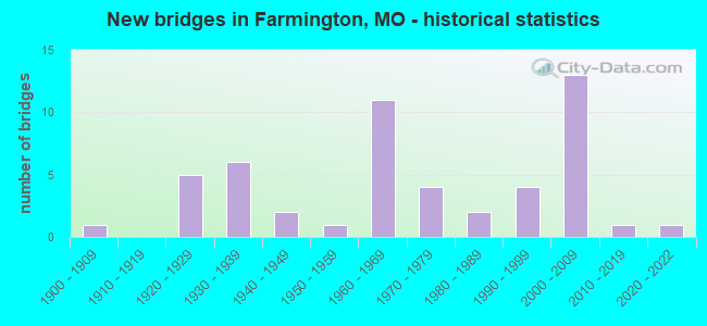
- New bridges - historical statistics
- 11900-1909
- 51920-1929
- 61930-1939
- 21940-1949
- 11950-1959
- 111960-1969
- 41970-1979
- 21980-1989
- 41990-1999
- 132000-2009
- 12010-2019
- 12020-2022
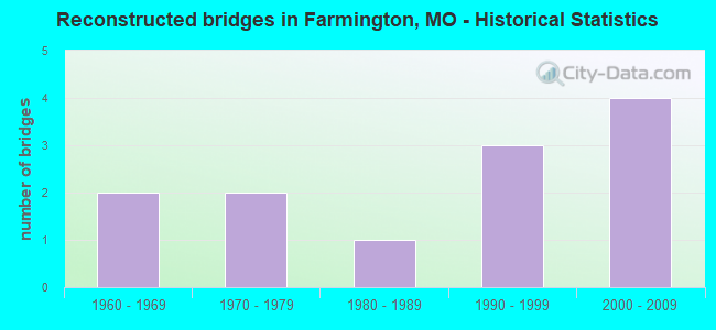
- Reconstructed bridges - Historical Statistics
- 21960-1969
- 21970-1979
- 11980-1989
- 31990-1999
- 42000-2009
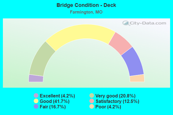
- Bridge Condition - Deck
- 4.2%Excellent
- 20.8%Very good
- 41.7%Good
- 12.5%Satisfactory
- 16.7%Fair
- 4.2%Poor
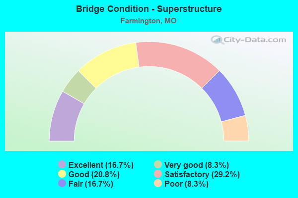
- Bridge Condition - Superstructure
- 16.7%Excellent
- 8.3%Very good
- 20.8%Good
- 29.2%Satisfactory
- 16.7%Fair
- 8.3%Poor
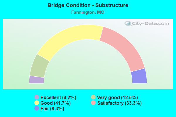
- Bridge Condition - Substructure
- 4.2%Excellent
- 12.5%Very good
- 41.7%Good
- 33.3%Satisfactory
- 8.3%Fair
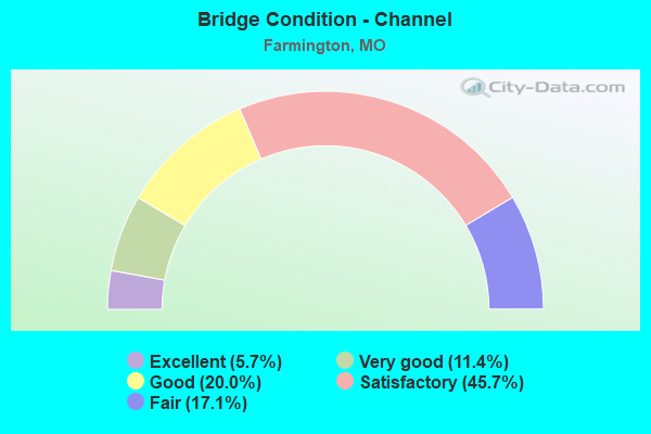
- Bridge Condition - Channel
- 5.7%Excellent
- 11.4%Very good
- 20.0%Good
- 45.7%Satisfactory
- 17.1%Fair
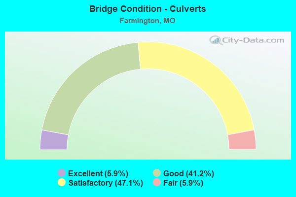
- Bridge Condition - Culverts
- 5.9%Excellent
- 41.2%Good
- 47.1%Satisfactory
- 5.9%Fair
Find on map >> Show street view
Structure Number: 12061, Location: S 26 T 36 N R 5 E (Lat: 37.795750, Lng: -90.442406), Route carried "under" structure: US 67, Year Built: 2000, Structure Length: 0. m, Average Daily Traffic: 12,031 (year 2021), Truck Traffic: 9%, Features Intersected: US 67
Minimum Vertical Clearance: 8.66m (28.41ft), Kilometerpoint: 153.937, Lanes on structure: 1, Lanes under structure: 2, Material/Design: Steel continuous, Design/Construction: Stringer/Multi-beam, Length of Maximum Span: 49.8m (163.4ft)
Find on map >> Show street view
Structure Number: 247, Location: S 298 T 35 N R 5 E (Lat: 37.771811, Lng: -90.445161), Route carried "under" structure: US 67, Year Built: 1963, Structure Length: 0. m, Average Daily Traffic: 8,786 (year 2021), Truck Traffic: 12%, Features Intersected: US 67, Facility Carried by Structure: MO 221 S
Minimum Vertical Clearance: 4.73m (15.52ft), Kilometerpoint: 156.562, Lanes on structure: 4, Lanes under structure: 2, Material/Design: Steel continuous, Design/Construction: Stringer/Multi-beam, Length of Maximum Span: 22.9m (75.1ft)
Find on map >> Show street view
Structure Number: 247, Location: S 298 T 35 N R 5 E (Lat: 37.771811, Lng: -90.445161), Route carried "under" structure: US 67, Year Built: 1963, Structure Length: 0. m, Average Daily Traffic: 7,337 (year 2021), Truck Traffic: 12%, Features Intersected: US 67, Facility Carried by Structure: MO 221 S
Minimum Vertical Clearance: 4.72m (15.49ft), Kilometerpoint: 161.551, Lanes on structure: 4, Lanes under structure: 2, Material/Design: Steel continuous, Design/Construction: Stringer/Multi-beam, Length of Maximum Span: 22.9m (75.1ft)
Find on map >> Show street view
Structure Number: 2963, Location: S 2969 T 36 N R 5 E (Lat: 37.789789, Lng: -90.443592), Route carried "under" structure: US 67, Year Built: 2003, Structure Length: 0. m, Average Daily Traffic: 11,496 (year 2021), Truck Traffic: 8%, Features Intersected: US 67, Facility Carried by Structure: MAPLE ST E
Minimum Vertical Clearance: 5.26m (17.26ft), Kilometerpoint: 163.551, Lanes on structure: 2, Lanes under structure: 2, Material/Design: Prestressed concrete continuous, Design/Construction: Stringer/Multi-beam, Length of Maximum Span: 27.7m (90.9ft)
Find on map >> Show street view
Structure Number: 2963, Location: S 2969 T 36 N R 5 E (Lat: 37.789789, Lng: -90.443592), Route carried "under" structure: US 67, Year Built: 2003, Structure Length: 0. m, Average Daily Traffic: 12,031 (year 2021), Truck Traffic: 9%, Features Intersected: US 67, Facility Carried by Structure: MAPLE ST E
Minimum Vertical Clearance: 5.08m (16.67ft), Kilometerpoint: 154.541, Lanes on structure: 2, Lanes under structure: 2, Material/Design: Prestressed concrete continuous, Design/Construction: Stringer/Multi-beam, Length of Maximum Span: 27.7m (90.9ft)
Find on map >> Show street view
Structure Number: 3163, Location: S 15 T 36 N R 5 E (Lat: 37.822978, Lng: -90.461419), Route carried "under" structure: US 67, Year Built: 2006, Structure Length: 0. m, Average Daily Traffic: 17,330 (year 2021), Truck Traffic: 9%, Features Intersected: US 67, Facility Carried by Structure: FAIRGROUNDS DR N
Minimum Vertical Clearance: 5.66m (18.57ft), Kilometerpoint: 150.381, Lanes on structure: 2, Lanes under structure: 2, Material/Design: Prestressed concrete continuous, Design/Construction: Stringer/Multi-beam, Length of Maximum Span: 27.4m (89.9ft)
Find on map >> Show street view
Structure Number: 3163, Location: S 15 T 36 N R 5 E (Lat: 37.822978, Lng: -90.461419), Route carried "under" structure: US 67, Year Built: 2006, Structure Length: 0. m, Average Daily Traffic: 17,190 (year 2021), Truck Traffic: 8%, Features Intersected: US 67, Facility Carried by Structure: FAIRGROUNDS DR N
Minimum Vertical Clearance: 5.56m (18.24ft), Kilometerpoint: 167.782, Lanes on structure: 2, Lanes under structure: 2, Material/Design: Prestressed concrete continuous, Design/Construction: Stringer/Multi-beam, Length of Maximum Span: 27.4m (89.9ft)
Find on map >> Show street view
Structure Number: 447, Location: S 26 T 36 N R 5 E (Lat: 37.796431, Lng: -90.442508), Route carried "under" structure: State highway 32, Year Built: 1963, Structure Length: 0. m, Average Daily Traffic: 9,480 (year 2021), Truck Traffic: 5%, Features Intersected: MO 32, Facility Carried by Structure: US 67 N
Minimum Vertical Clearance: 4.62m (15.16ft), Kilometerpoint: 408.464, Lanes on structure: 2, Lanes under structure: 2, Material/Design: Steel continuous, Design/Construction: Stringer/Multi-beam, Length of Maximum Span: 24.4m (80.1ft)