Bridge Statistics for Fenton, Missouri (MO)
Condition, Traffic, Stress, Structural Evaluation, Project Costs
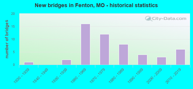
- New bridges - historical statistics
- 11930-1939
- 21950-1959
- 161960-1969
- 121970-1979
- 81980-1989
- 41990-1999
- 32000-2009
- 62010-2019

- Reconstructed bridges - Historical Statistics
- 11970-1979
- 11980-1989
- 31990-1999


- Bridge Condition - Deck
- 5.0%Very good
- 30.0%Good
- 60.0%Satisfactory
- 5.0%Fair

- Bridge Condition - Superstructure
- 15.0%Very good
- 30.0%Good
- 50.0%Satisfactory
- 5.0%Fair

- Bridge Condition - Substructure
- 5.0%Very good
- 25.0%Good
- 60.0%Satisfactory
- 10.0%Fair

- Bridge Condition - Channel
- 7.7%Excellent
- 23.1%Good
- 50.0%Satisfactory
- 19.2%Fair

- Bridge Condition - Culverts
- 6.7%Good
- 73.3%Satisfactory
- 20.0%Fair
Find on map >> Show street view
Structure Number: 1418, Location: S 12 T 44 N R 6 E (Lat: 38.576611, Lng: -90.379611), Route carried "on" structure: Interstate 44, Year Built: 1969, Status: Open, Structure Length: 1.10m (3.61ft), Average Daily Traffic: 96,042 (year 2021), Truck Traffic: 12%, Average Future Daily Traffic: 120,053 (year 2041), Design Load: HS 20, Features Intersected: BR GRAVOIS CR
Minimum Vertical Clearance: 30+ m (98+ ft), Kilometerpoint: 449.962, Lanes on structure: 6, Base Highway Network: Yes, Owner: State Highway Agency, Approaching Roadway Width: 43.9m (144.0ft), Skew: 20 degrees, Material/Design: Concrete continuous, Design/Construction: Culvert, Number Of Spans In Main Unit: 3, Length of Maximum Span: 3.7m (12.1ft)
Condition: Channel: Satisfactory, Culverts: Satisfactory, Operating Rating: 87.3 metric tons, Method Used To Determine Operating Rating: Field evaluation and documented engineering judgment, Inventory Rating: 52.2 metric tons, Method Used To Determine Inventory Rating: Field evaluation and documented engineering judgment, Structural Evaluation: Equal to present minimum criteria, Waterway Adequacy: Equal to present desirable criteria, Approach Roadway Alignment: Equal to present desirable criteria, Designated Inspection Frequency: Every 24 months, Inspection Date: November 2021
Find on map >> Show street view
Structure Number: 1419, Location: S 5 T 44 N R 6 E (Lat: 38.575947, Lng: -90.377264), Route carried "on" structure: Interstate 44, Year Built: 1969, Status: Open, Structure Length: 5.15m (16.90ft), Average Daily Traffic: 47,034 (year 2021), Truck Traffic: 12%, Average Future Daily Traffic: 58,793 (year 2041), Design Load: HS 20+Mod, Features Intersected: CST BERRY RD
Minimum Vertical Clearance: 30+ m (98+ ft), Kilometerpoint: 450.175, Lanes on structure: 4, Lanes under structure: 3, Base Highway Network: Yes, Owner: State Highway Agency, Approaching Roadway Width: 20.1m (65.9ft), Skew: 1 degrees, Material/Design: Concrete continuous, Design/Construction: Slab, Number Of Spans In Main Unit: 4, Length of Maximum Span: 15.2m (49.9ft), Curb-To-Curb Width: 20.3m (66.6ft), Out-to-Out Width: 21.4m (70.2ft)
Condition: Deck: Satisfactory, Superstructure: Satisfactory, Substructure: Fair, Operating Rating: 59.4 metric tons, Method Used To Determine Operating Rating: Load Factor (LF), Inventory Rating: 36.0 metric tons, Method Used To Determine Inventory Rating: Load Factor (LF), Structural Evaluation: Somewhat better than minimum adequacy, Deck Geometry: Equal to present minimum criteria, Underclear: Equal to present minimum criteria, Approach Roadway Alignment: Equal to present desirable criteria, Designated Inspection Frequency: Every 24 months, Inspection Date: June 2020, Deck Structure Type: Concrete Cast-file-Place, Wearing Surface/Protective System: Wearing Surface: Bituminous, Membrane: Built-up
Find on map >> Show street view
Structure Number: 142, Location: S 2039 T 47 N R 5 E (Lat: 38.771450, Lng: -90.403092), Route carried "on" structure: Interstate 270, Year Built: 1960, Year Reconstructed: 1990, Status: Open, Structure Length: 4.69m (15.39ft), Average Daily Traffic: 113,650 (year 2021), Truck Traffic: 18%, Average Future Daily Traffic: 142,063 (year 2041), Design Load: HS 20+Mod, Features Intersected: NS RR
Minimum Vertical Clearance: 30+ m (98+ ft), Kilometerpoint: 36.933, Lanes on structure: 8, Base Highway Network: Yes, Owner: State Highway Agency, Approaching Roadway Width: 39.0m (128.0ft), Skew: 1 degrees, Material/Design: Steel continuous, Design/Construction: Stringer/Multi-beam, Number Of Spans In Main Unit: 3, Length of Maximum Span: 17.7m (58.1ft), Curb or Sidewalk Widths: Left: 0.2m (0.7ft), Right: 0.2m (0.7ft), Curb-To-Curb Width: 37.8m (124.0ft), Out-to-Out Width: 39.5m (129.6ft)
Condition: Deck: Fair, Superstructure: Satisfactory, Substructure: Satisfactory, Operating Rating: 70.2 metric tons, Method Used To Determine Operating Rating: Load Factor (LF), Inventory Rating: 42.3 metric tons, Method Used To Determine Inventory Rating: Load Factor (LF), Structural Evaluation: Equal to present minimum criteria, Deck Geometry: Superior to present desirable criteria, Underclear: Superior to present desirable criteria, Approach Roadway Alignment: Equal to present desirable criteria, Designated Inspection Frequency: Every 24 months, Inspection Date: August 2020, Deck Structure Type: Concrete Cast-file-Place, Wearing Surface/Protective System: Wearing Surface: Monolithic Concrete
Find on map >> Show street view
Structure Number: 142, Location: S 5 T 44 N R 6 E (Lat: 38.576108, Lng: -90.377258), Route carried "on" structure: Interstate 44, Year Built: 1969, Status: Open, Structure Length: 5.15m (16.90ft), Average Daily Traffic: 58,299 (year 2021), Truck Traffic: 12%, Average Future Daily Traffic: 72,874 (year 2041), Design Load: HS 20+Mod, Features Intersected: CST BERRY RD
Minimum Vertical Clearance: 30+ m (98+ ft), Kilometerpoint: 21.464, Lanes on structure: 4, Lanes under structure: 3, Base Highway Network: Yes, Owner: State Highway Agency, Approaching Roadway Width: 20.1m (65.9ft), Skew: 1 degrees, Material/Design: Concrete continuous, Design/Construction: Slab, Number Of Spans In Main Unit: 4, Length of Maximum Span: 15.2m (49.9ft), Curb-To-Curb Width: 20.0m (65.6ft), Out-to-Out Width: 20.8m (68.2ft)
Condition: Deck: Satisfactory, Superstructure: Satisfactory, Substructure: Satisfactory, Operating Rating: 59.4 metric tons, Method Used To Determine Operating Rating: Load Factor (LF), Inventory Rating: 36.0 metric tons, Method Used To Determine Inventory Rating: Load Factor (LF), Structural Evaluation: Equal to present minimum criteria, Deck Geometry: Equal to present minimum criteria, Underclear: Equal to present minimum criteria, Approach Roadway Alignment: Equal to present desirable criteria, Designated Inspection Frequency: Every 24 months, Inspection Date: June 2020, Deck Structure Type: Concrete Cast-file-Place, Wearing Surface/Protective System: Wearing Surface: Bituminous, Membrane: Built-up
Find on map >> Show street view
Structure Number: 15644, Location: S 28 T 44 N R 6 E (Lat: 38.521378, Lng: -90.460950), Route carried "on" structure: County highway , Year Built: 1930, Year Reconstructed: 1981, Status: Posted for load, Structure Length: 0.79m (2.59ft), Average Daily Traffic: 11 (year 2020), Truck Traffic: 1%, Average Future Daily Traffic: 15 (year 2040), Design Load: HS 20, Features Intersected: FENTON CR, Facility Carried by Structure: OLD SMIZER MILL RD
Minimum Vertical Clearance: 30+ m (98+ ft), Kilometerpoint: 7.242, Lanes on structure: 1, Owner: County Highway Agency, Approaching Roadway Width: 4.9m (16.1ft), Material/Design: Prestressed concrete, Design/Construction: Box Beam or Girders - Multiple, Number Of Spans In Main Unit: 1, Length of Maximum Span: 7.3m (24.0ft), Curb-To-Curb Width: 5.2m (17.1ft), Out-to-Out Width: 5.5m (18.0ft)
Condition: Deck: Good, Superstructure: Good, Substructure: Fair, Channel: Fair, Operating Rating: 32.4 metric tons, Method Used To Determine Operating Rating: Allowable Stress (AS), Inventory Rating: 11.7 metric tons, Method Used To Determine Inventory Rating: Allowable Stress (AS), Structural Evaluation: Meets minimum limits, Deck Geometry: High priority of corrective action, Waterway Adequacy: Better than present minimum criteria, Approach Roadway Alignment: Equal to present minimum criteria, Length Of Structure Improvement: 0.14m (0.46ft), Designated Inspection Frequency: Every 24 months, Inspection Date: March 2021, Bridge Improvement Cost: $102,000, Roadway Improvement Cost: $10,000, Total Project Cost: $153,000 ( Estimate for 2022), Deck Structure Type: Other, Wearing Surface/Protective System: Wearing Surface: Bituminous
Find on map >> Show street view
Structure Number: 157, Location: S 27 T 37 N R 32 W (Lat: 37.962664, Lng: -94.449242), Route carried "on" structure: State highway WW, Year Built: 1957, Status: Open, Structure Length: 0.78m (2.56ft), Average Daily Traffic: 362 (year 2021), Truck Traffic: 12%, Average Future Daily Traffic: 507 (year 2041), Design Load: H 15, Features Intersected: CHRISTIAN CR
Minimum Vertical Clearance: 30+ m (98+ ft), Kilometerpoint: 16.835, Lanes on structure: 2, Owner: State Highway Agency, Approaching Roadway Width: 7.3m (24.0ft), Skew: 1 degrees, Material/Design: Concrete continuous, Design/Construction: Culvert, Number Of Spans In Main Unit: 2, Length of Maximum Span: 3.7m (12.1ft), Curb-To-Curb Width: 8.1m (26.6ft), Out-to-Out Width: 8.7m (28.5ft)
Condition: Channel: Satisfactory, Culverts: Satisfactory, Operating Rating: 70.2 metric tons, Method Used To Determine Operating Rating: Load Factor (LF), Inventory Rating: 42.3 metric tons, Method Used To Determine Inventory Rating: Load Factor (LF), Structural Evaluation: Equal to present minimum criteria, Deck Geometry: Somewhat better than minimum adequacy, Waterway Adequacy: Equal to present minimum criteria, Approach Roadway Alignment: Equal to present desirable criteria, Designated Inspection Frequency: Every 24 months, Inspection Date: March 2022
Find on map >> Show street view
Structure Number: 157, Location: S 20 T 44 N R 5 E (Lat: 38.539361, Lng: -90.473556), Route carried "on" structure: County highway , Year Built: 1980, Year Reconstructed: 1991, Status: Posted for load, Structure Length: 1.10m (3.61ft), Average Daily Traffic: 22,842 (year 2020), Truck Traffic: 5%, Average Future Daily Traffic: 30,837 (year 2040), Design Load: HS 20, Features Intersected: YARNELL CR, Facility Carried by Structure: BOWLES AVE
Minimum Vertical Clearance: 30+ m (98+ ft), Kilometerpoint: 0.000, Lanes on structure: 5, Owner: County Highway Agency, Approaching Roadway Width: 19.2m (63.0ft), Material/Design: Concrete continuous, Design/Construction: Culvert, Number Of Spans In Main Unit: 2, Length of Maximum Span: 3.7m (12.1ft), Curb or Sidewalk Widths: Left: 1.2m (3.9ft), Right: 1.2m (3.9ft)
Condition: Channel: Satisfactory, Culverts: Satisfactory, Operating Rating: 89.1 metric tons, Method Used To Determine Operating Rating: Allowable Stress (AS), Inventory Rating: 62.1 metric tons, Method Used To Determine Inventory Rating: Allowable Stress (AS), Structural Evaluation: Equal to present minimum criteria, Waterway Adequacy: Superior to present desirable criteria, Approach Roadway Alignment: Better than present minimum criteria, Designated Inspection Frequency: Every 24 months, Inspection Date: March 2021
Find on map >> Show street view
Structure Number: 15702, Location: S 28 T 44 N R 5 E (Lat: 38.520000, Lng: -90.466667), Route carried "on" structure: County highway , Year Built: 1994, Status: Posted for load, Structure Length: 1.43m (4.69ft), Average Daily Traffic: 1,023 (year 2020), Truck Traffic: 2%, Average Future Daily Traffic: 1,381 (year 2040), Features Intersected: FENTON CR, Facility Carried by Structure: MAY VALLEY DR
Minimum Vertical Clearance: 30+ m (98+ ft), Kilometerpoint: 0.000, Lanes on structure: 2, Owner: County Highway Agency, Approaching Roadway Width: 7.9m (25.9ft), Material/Design: Concrete continuous, Design/Construction: Culvert, Number Of Spans In Main Unit: 3, Length of Maximum Span: 4.3m (14.1ft), Curb or Sidewalk Widths: Left: 1.5m (4.9ft), Right: 1.5m (4.9ft)
Condition: Channel: Fair, Culverts: Satisfactory, Operating Rating: 82.8 metric tons, Method Used To Determine Operating Rating: Allowable Stress (AS), Inventory Rating: 49.5 metric tons, Method Used To Determine Inventory Rating: Allowable Stress (AS), Structural Evaluation: Equal to present minimum criteria, Waterway Adequacy: Equal to present desirable criteria, Approach Roadway Alignment: Better than present minimum criteria, Designated Inspection Frequency: Every 24 months, Inspection Date: March 2021
Find on map >> Show street view
Structure Number: 15703, Location: S 29 T 44 N R 5 E (Lat: 38.519378, Lng: -90.458306), Route carried "on" structure: County highway , Year Built: 1965, Status: Posted for load, Structure Length: 1.04m (3.41ft), Average Daily Traffic: 766 (year 2020), Truck Traffic: 2%, Average Future Daily Traffic: 1,034 (year 2040), Features Intersected: FENTON CR, Facility Carried by Structure: OAKWOOD DR
Minimum Vertical Clearance: 30+ m (98+ ft), Kilometerpoint: 7.403, Lanes on structure: 2, Owner: County Highway Agency, Approaching Roadway Width: 7.6m (24.9ft), Material/Design: Steel, Design/Construction: Culvert, Number Of Spans In Main Unit: 1, Length of Maximum Span: 9.1m (29.9ft), Curb or Sidewalk Widths: Left: 1.2m (3.9ft), Right: 1.2m (3.9ft)
Condition: Channel: Satisfactory, Culverts: Fair, Operating Rating: 35.1 metric tons, Method Used To Determine Operating Rating: Allowable Stress (AS), Inventory Rating: 22.5 metric tons, Method Used To Determine Inventory Rating: Allowable Stress (AS), Structural Evaluation: Somewhat better than minimum adequacy, Waterway Adequacy: Better than present minimum criteria, Approach Roadway Alignment: Better than present minimum criteria, Designated Inspection Frequency: Every 24 months, Inspection Date: March 2021
Find on map >> Show street view
Structure Number: 1694, Location: S 373 T 44 N R 5 E (Lat: 38.516961, Lng: -90.425958), Route carried "on" structure: State highway 30, Year Built: 1968, Status: Open, Structure Length: 0.62m (2.03ft), Average Daily Traffic: 42,740 (year 2021), Truck Traffic: 4%, Average Future Daily Traffic: 53,425 (year 2041), Design Load: HS 20, Features Intersected: SUNSET HILL CR
Minimum Vertical Clearance: 30+ m (98+ ft), Kilometerpoint: 63.162, Lanes on structure: 4, Base Highway Network: Yes, Owner: State Highway Agency, Approaching Roadway Width: 39.0m (128.0ft), Skew: 11 degrees, Material/Design: Concrete, Design/Construction: Culvert, Number Of Spans In Main Unit: 1, Length of Maximum Span: 6.1m (20.0ft)
Condition: Channel: Satisfactory, Culverts: Fair, Operating Rating: 87.3 metric tons, Method Used To Determine Operating Rating: Field evaluation and documented engineering judgment, Inventory Rating: 52.2 metric tons, Method Used To Determine Inventory Rating: Field evaluation and documented engineering judgment, Structural Evaluation: Somewhat better than minimum adequacy, Waterway Adequacy: Equal to present desirable criteria, Approach Roadway Alignment: Equal to present desirable criteria, Designated Inspection Frequency: Every 24 months, Inspection Date: November 2021
Find on map >> Show street view
Structure Number: 1695, Location: S 373 T 44 N R 5 E (Lat: 38.515894, Lng: -90.435608), Route carried "on" structure: State highway 30, Year Built: 1968, Year Reconstructed: 2004, Status: Posted for load, Structure Length: 37.09m (121.69ft), Average Daily Traffic: 21,203 (year 2021), Truck Traffic: 4%, Average Future Daily Traffic: 26,504 (year 2041), Design Load: HS 20, Features Intersected: MERAMEC RVR, CST WATER S
Minimum Vertical Clearance: 30+ m (98+ ft), Kilometerpoint: 62.113, Lanes on structure: 2, Lanes under structure: 2, Base Highway Network: Yes, Owner: State Highway Agency, Approaching Roadway Width: 11.6m (38.1ft), Material/Design: Steel continuous, Design/Construction: Stringer/Multi-beam, Number Of Spans In Main Unit: 11, Length of Maximum Span: 51.8m (169.9ft), Curb-To-Curb Width: 11.6m (38.1ft), Out-to-Out Width: 12.4m (40.7ft)
Condition: Deck: Satisfactory, Superstructure: Good, Substructure: Satisfactory, Channel: Good, Operating Rating: 50.4 metric tons, Method Used To Determine Operating Rating: Load Factor (LF), Inventory Rating: 30.6 metric tons, Method Used To Determine Inventory Rating: Load Factor (LF), Structural Evaluation: Equal to present minimum criteria, Deck Geometry: Equal to present minimum criteria, Underclear: Superior to present desirable criteria, Waterway Adequacy: Equal to present minimum criteria, Approach Roadway Alignment: Equal to present desirable criteria, Designated Inspection Frequency: Every 24 months, Underwater Inspection Frequency: Every 60 months, Inspection Date: July 2020, Underwater Inspection Date: June 2020, Deck Structure Type: Concrete Cast-file-Place, Wearing Surface/Protective System: Wearing Surface: Monolithic Concrete
Find on map >> Show street view
Structure Number: 17081, Location: S 22 T 44 N R 5 E (Lat: 38.534656, Lng: -90.454931), Route carried "on" structure: City street , Year Built: 1975, Status: Open, Structure Length: 0.98m (3.22ft), Average Daily Traffic: 500 (year 2020), Truck Traffic: 10%, Average Future Daily Traffic: 675 (year 2040), Features Intersected: BR OF YARNELL CR, Facility Carried by Structure: LARKIN-WM INDUS DR
Minimum Vertical Clearance: 30+ m (98+ ft), Kilometerpoint: 0.322, Lanes on structure: 2, Owner: City or Municipal Highway Agency, Approaching Roadway Width: 8.5m (27.9ft), Material/Design: Concrete, Design/Construction: Culvert, Number Of Spans In Main Unit: 2, Length of Maximum Span: 4.6m (15.1ft), Curb-To-Curb Width: 8.6m (28.2ft), Out-to-Out Width: 8.6m (28.2ft)
Condition: Channel: Satisfactory, Culverts: Satisfactory, Operating Rating: 49.5 metric tons, Method Used To Determine Operating Rating: Allowable Stress (AS), Inventory Rating: 16.2 metric tons, Method Used To Determine Inventory Rating: Allowable Stress (AS), Structural Evaluation: Somewhat better than minimum adequacy, Deck Geometry: Somewhat better than minimum adequacy, Waterway Adequacy: Equal to present minimum criteria, Approach Roadway Alignment: Equal to present desirable criteria, Designated Inspection Frequency: Every 24 months, Inspection Date: November 2021
Find on map >> Show street view
Structure Number: 17083, Location: S 21 T 44 N R 6 E (Lat: 38.539828, Lng: -90.464300), Route carried "on" structure: City street , Year Built: 1975, Status: Open, Structure Length: 0.98m (3.22ft), Average Daily Traffic: 2,000 (year 2020), Truck Traffic: 6%, Average Future Daily Traffic: 2,700 (year 2040), Features Intersected: BR OF MERAMEC RVR, Facility Carried by Structure: GILSINN LN
Minimum Vertical Clearance: 30+ m (98+ ft), Kilometerpoint: 0.483, Lanes on structure: 2, Owner: City or Municipal Highway Agency, Approaching Roadway Width: 8.8m (28.9ft), Material/Design: Concrete, Design/Construction: Culvert, Number Of Spans In Main Unit: 3, Length of Maximum Span: 3.0m (9.8ft)
Condition: Channel: Fair, Culverts: Satisfactory, Operating Rating: 49.5 metric tons, Method Used To Determine Operating Rating: Allowable Stress (AS), Inventory Rating: 32.4 metric tons, Method Used To Determine Inventory Rating: Allowable Stress (AS), Structural Evaluation: Equal to present minimum criteria, Waterway Adequacy: Superior to present desirable criteria, Approach Roadway Alignment: Equal to present desirable criteria, Designated Inspection Frequency: Every 24 months, Inspection Date: November 2021
Find on map >> Show street view
Structure Number: 17085, Location: S 27 T 44 N R 5 E (Lat: 38.530156, Lng: -90.452308), Route carried "on" structure: City street , Year Built: 1991, Status: Open, Structure Length: 3.35m (10.99ft), Average Daily Traffic: 300 (year 2020), Truck Traffic: 1%, Average Future Daily Traffic: 405 (year 2040), Design Load: HS 20, Features Intersected: YARNELL CR, Facility Carried by Structure: MONTEVALE CT
Minimum Vertical Clearance: 30+ m (98+ ft), Kilometerpoint: 0.644, Lanes on structure: 2, Owner: City or Municipal Highway Agency, Approaching Roadway Width: 7.9m (25.9ft), Skew: 3 degrees, Material/Design: Prestressed concrete, Design/Construction: Stringer/Multi-beam, Number Of Spans In Main Unit: 2, Length of Maximum Span: 16.8m (55.1ft), Curb or Sidewalk Widths: Left: 0.0m, Right: 1.2m (3.9ft), Curb-To-Curb Width: 7.9m (25.9ft), Out-to-Out Width: 10.1m (33.1ft)
Condition: Deck: Good, Superstructure: Good, Substructure: Good, Channel: Good, Operating Rating: 49.5 metric tons, Method Used To Determine Operating Rating: Allowable Stress (AS), Inventory Rating: 32.4 metric tons, Method Used To Determine Inventory Rating: Allowable Stress (AS), Structural Evaluation: Better than present minimum criteria, Deck Geometry: Somewhat better than minimum adequacy, Waterway Adequacy: Superior to present desirable criteria, Approach Roadway Alignment: Equal to present desirable criteria, Designated Inspection Frequency: Every 24 months, Inspection Date: November 2021, Deck Structure Type: Concrete Cast-file-Place, Wearing Surface/Protective System: Wearing Surface: Monolithic Concrete
Find on map >> Show street view
Structure Number: 17095, Location: S 21 T 44 N R 5 E (Lat: 38.538089, Lng: -90.457083), Route carried "on" structure: City street , Year Built: 1975, Status: Posted for load, Structure Length: 0.94m (3.08ft), Average Daily Traffic: 9,500 (year 2020), Truck Traffic: 25%, Average Future Daily Traffic: 12,825 (year 2040), Features Intersected: TRIB MERAMEC RVR, Facility Carried by Structure: HORAN DR
Minimum Vertical Clearance: 30+ m (98+ ft), Kilometerpoint: 0.000, Lanes on structure: 2, Owner: City or Municipal Highway Agency, Approaching Roadway Width: 7.3m (24.0ft), Material/Design: Concrete continuous, Design/Construction: Culvert, Number Of Spans In Main Unit: 3, Length of Maximum Span: 2.7m (8.9ft)
Condition: Channel: Fair, Culverts: Good, Operating Rating: 44.1 metric tons, Method Used To Determine Operating Rating: Allowable Stress (AS), Inventory Rating: 27.0 metric tons, Method Used To Determine Inventory Rating: Allowable Stress (AS), Structural Evaluation: Equal to present minimum criteria, Waterway Adequacy: Somewhat better than minimum adequacy, Approach Roadway Alignment: Equal to present desirable criteria, Designated Inspection Frequency: Every 24 months, Inspection Date: November 2021
Find on map >> Show street view
Structure Number: 17098, Location: S 373 T 44 N R 5 E (Lat: 38.516328, Lng: -90.437061), Route carried "on" structure: City street , Year Built: 1980, Status: Posted for load, Structure Length: 0.91m (2.99ft), Average Daily Traffic: 10,000 (year 2020), Truck Traffic: 1%, Average Future Daily Traffic: 13,500 (year 2040), Features Intersected: TRIB MERAMEC RVR, Facility Carried by Structure: LARKIN-WILLIAMS
Minimum Vertical Clearance: 30+ m (98+ ft), Kilometerpoint: 0.000, Lanes on structure: 2, Owner: City or Municipal Highway Agency, Approaching Roadway Width: 7.0m (23.0ft), Material/Design: Steel, Design/Construction: Culvert, Number Of Spans In Main Unit: 1, Length of Maximum Span: 9.1m (29.9ft), Curb-To-Curb Width: 8.7m (28.5ft), Out-to-Out Width: 11.2m (36.7ft)
Condition: Channel: Satisfactory, Culverts: Satisfactory, Operating Rating: 49.5 metric tons, Method Used To Determine Operating Rating: Field evaluation and documented engineering judgment, Inventory Rating: 16.2 metric tons, Method Used To Determine Inventory Rating: Field evaluation and documented engineering judgment, Structural Evaluation: Meets minimum limits, Deck Geometry: High priority of replacement, Waterway Adequacy: Somewhat better than minimum adequacy, Approach Roadway Alignment: Equal to present desirable criteria, Length Of Structure Improvement: 0.16m (0.52ft), Designated Inspection Frequency: Every 24 months, Inspection Date: November 2021, Bridge Improvement Cost: $85,000, Roadway Improvement Cost: $9,000, Total Project Cost: $128,000 ( Estimate for 2022)
Find on map >> Show street view
Structure Number: 1898, Location: S 373 T 44 N R 5 E (Lat: 38.514142, Lng: -90.446125), Route carried "on" structure: State highway 30, Year Built: 1970, Status: Open, Structure Length: 6.55m (21.49ft), Average Daily Traffic: 17,507 (year 2021), Truck Traffic: 7%, Average Future Daily Traffic: 21,884 (year 2041), Design Load: HS 20, Features Intersected: MO 141
Minimum Vertical Clearance: 30+ m (98+ ft), Kilometerpoint: 61.324, Lanes on structure: 2, Lanes under structure: 10, Base Highway Network: Yes, Owner: State Highway Agency, Approaching Roadway Width: 11.6m (38.1ft), Material/Design: Concrete continuous, Design/Construction: Box Beam or Girders - Single/Spread, Number Of Spans In Main Unit: 3, Length of Maximum Span: 32.3m (106.0ft), Curb-To-Curb Width: 11.6m (38.1ft), Out-to-Out Width: 12.4m (40.7ft)
Condition: Deck: Satisfactory, Superstructure: Satisfactory, Substructure: Satisfactory, Operating Rating: 61.2 metric tons, Method Used To Determine Operating Rating: Load Factor (LF), Inventory Rating: 36.9 metric tons, Method Used To Determine Inventory Rating: Load Factor (LF), Structural Evaluation: Equal to present minimum criteria, Deck Geometry: Equal to present minimum criteria, Underclear: High priority of corrective action, Approach Roadway Alignment: Equal to present desirable criteria, Designated Inspection Frequency: Every 24 months, Inspection Date: June 2020, Deck Structure Type: Concrete Cast-file-Place, Wearing Surface/Protective System: Wearing Surface: Other, Membrane: Built-up, Deck Protection: Cathodic Protection
Find on map >> Show street view
Structure Number: 1899, Location: S 373 T 44 N R 5 E (Lat: 38.514325, Lng: -90.446286), Route carried "on" structure: State highway 30, Year Built: 1970, Status: Open, Structure Length: 6.55m (21.49ft), Average Daily Traffic: 21,537 (year 2021), Truck Traffic: 5%, Average Future Daily Traffic: 26,921 (year 2041), Design Load: HS 20, Features Intersected: MO 141
Minimum Vertical Clearance: 30+ m (98+ ft), Kilometerpoint: 23.437, Lanes on structure: 2, Lanes under structure: 10, Base Highway Network: Yes, Owner: State Highway Agency, Approaching Roadway Width: 11.6m (38.1ft), Material/Design: Concrete continuous, Design/Construction: Box Beam or Girders - Single/Spread, Number Of Spans In Main Unit: 3, Length of Maximum Span: 32.3m (106.0ft), Curb-To-Curb Width: 11.6m (38.1ft), Out-to-Out Width: 12.4m (40.7ft)
Condition: Deck: Satisfactory, Superstructure: Satisfactory, Substructure: Satisfactory, Operating Rating: 61.2 metric tons, Method Used To Determine Operating Rating: Load Factor (LF), Inventory Rating: 36.9 metric tons, Method Used To Determine Inventory Rating: Load Factor (LF), Structural Evaluation: Equal to present minimum criteria, Deck Geometry: Equal to present minimum criteria, Underclear: High priority of corrective action, Approach Roadway Alignment: Equal to present desirable criteria, Designated Inspection Frequency: Every 24 months, Inspection Date: June 2020, Deck Structure Type: Concrete Cast-file-Place, Wearing Surface/Protective System: Wearing Surface: Other, Membrane: Built-up, Deck Protection: Cathodic Protection
Find on map >> Show street view
Structure Number: 19, Location: S 373 T 44 N R 5 E (Lat: 38.513603, Lng: -90.447169), Route carried "on" structure: State highway 30, Year Built: 1970, Status: Open, Structure Length: 1.27m (4.17ft), Average Daily Traffic: 34,808 (year 2021), Truck Traffic: 7%, Average Future Daily Traffic: 43,510 (year 2041), Design Load: HS 20, Features Intersected: FENTON CR
Minimum Vertical Clearance: 30+ m (98+ ft), Kilometerpoint: 61.212, Lanes on structure: 6, Base Highway Network: Yes, Owner: State Highway Agency, Approaching Roadway Width: 60.7m (199.1ft), Skew: 21 degrees, Material/Design: Concrete continuous, Design/Construction: Culvert, Number Of Spans In Main Unit: 3, Length of Maximum Span: 4.0m (13.1ft)
Condition: Channel: Fair, Culverts: Satisfactory, Operating Rating: 87.3 metric tons, Method Used To Determine Operating Rating: Field evaluation and documented engineering judgment, Inventory Rating: 52.2 metric tons, Method Used To Determine Inventory Rating: Field evaluation and documented engineering judgment, Structural Evaluation: Equal to present minimum criteria, Waterway Adequacy: Equal to present desirable criteria, Approach Roadway Alignment: Equal to present desirable criteria, Designated Inspection Frequency: Every 24 months, Inspection Date: November 2021
Find on map >> Show street view
Structure Number: 1901, Location: S 19 T 44 N R 5 E (Lat: 38.511847, Lng: -90.445464), Route carried "on" structure: City street , Year Built: 1970, Status: Posted for load, Structure Length: 2.53m (8.30ft), Average Daily Traffic: 9,015 (year 2021), Truck Traffic: 5%, Average Future Daily Traffic: 13,523 (year 2041), Design Load: H 20, Features Intersected: FENTON CR, Facility Carried by Structure: GRAVOIS RD E
Minimum Vertical Clearance: 30+ m (98+ ft), Kilometerpoint: 0.837, Lanes on structure: 3, Owner: State Highway Agency, Approaching Roadway Width: 11.6m (38.1ft), Material/Design: Concrete continuous, Design/Construction: Slab, Number Of Spans In Main Unit: 3, Length of Maximum Span: 9.8m (32.2ft), Curb-To-Curb Width: 13.4m (44.0ft), Out-to-Out Width: 14.2m (46.6ft)
Condition: Deck: Satisfactory, Superstructure: Satisfactory, Substructure: Satisfactory, Channel: Satisfactory, Operating Rating: 43.2 metric tons, Method Used To Determine Operating Rating: Load Factor (LF), Inventory Rating: 26.1 metric tons, Method Used To Determine Inventory Rating: Load Factor (LF), Structural Evaluation: Equal to present minimum criteria, Deck Geometry: Somewhat better than minimum adequacy, Waterway Adequacy: Equal to present desirable criteria, Approach Roadway Alignment: Equal to present desirable criteria, Designated Inspection Frequency: Every 24 months, Inspection Date: November 2020, Deck Structure Type: Concrete Cast-file-Place, Wearing Surface/Protective System: Wearing Surface: Epoxy Overlay
Find on map >> Show street view
Structure Number: 233, Location: S 373 T 43 N R 5 E (Lat: 38.511161, Lng: -90.444794), Route carried "on" structure: State highway 141, Year Built: 1974, Status: Open, Structure Length: 3.05m (10.01ft), Average Daily Traffic: 31,660 (year 2021), Truck Traffic: 6%, Average Future Daily Traffic: 39,575 (year 2041), Design Load: HS 20, Features Intersected: FENTON CR
Minimum Vertical Clearance: 30+ m (98+ ft), Kilometerpoint: 37.823, Lanes on structure: 6, Base Highway Network: Yes, Owner: State Highway Agency, Approaching Roadway Width: 24.4m (80.1ft), Skew: 23 degrees, Material/Design: Steel continuous, Design/Construction: Stringer/Multi-beam, Number Of Spans In Main Unit: 3, Length of Maximum Span: 14.6m (47.9ft), Curb-To-Curb Width: 28.0m (91.9ft), Out-to-Out Width: 28.9m (94.8ft)
Condition: Deck: Good, Superstructure: Satisfactory, Substructure: Satisfactory, Channel: Good, Operating Rating: 70.2 metric tons, Method Used To Determine Operating Rating: Load Factor (LF), Inventory Rating: 42.3 metric tons, Method Used To Determine Inventory Rating: Load Factor (LF), Structural Evaluation: Equal to present minimum criteria, Deck Geometry: Equal to present minimum criteria, Waterway Adequacy: Equal to present desirable criteria, Approach Roadway Alignment: Equal to present desirable criteria, Designated Inspection Frequency: Every 24 months, Inspection Date: November 2020, Deck Structure Type: Concrete Cast-file-Place, Wearing Surface/Protective System: Wearing Surface: Latex Concrete
Find on map >> Show street view
Structure Number: 3196, Location: S 21 T 44 N R 5 E (Lat: 38.542772, Lng: -90.469378), Route carried "on" structure: City street , Year Built: 1981, Status: Posted for load, Structure Length: 8.78m (28.81ft), Average Daily Traffic: 19,549 (year 2020), Truck Traffic: 5%, Average Future Daily Traffic: 27,369 (year 2040), Design Load: HS 20+Mod, Features Intersected: IS 44, Facility Carried by Structure: BOWLES AVE S
Minimum Vertical Clearance: 30+ m (98+ ft), Kilometerpoint: 0.056, Lanes on structure: 5, Lanes under structure: 6, Owner: State Highway Agency, Approaching Roadway Width: 21.9m (71.9ft), Skew: 10 degrees, Material/Design: Steel continuous, Design/Construction: Stringer/Multi-beam, Number Of Spans In Main Unit: 2, Length of Maximum Span: 36.8m (120.7ft), Curb-To-Curb Width: 21.9m (71.9ft), Out-to-Out Width: 22.8m (74.8ft)
Condition: Deck: Satisfactory, Superstructure: Satisfactory, Substructure: Satisfactory, Operating Rating: 56.7 metric tons, Method Used To Determine Operating Rating: Load Factor (LF), Inventory Rating: 34.2 metric tons, Method Used To Determine Inventory Rating: Load Factor (LF), Structural Evaluation: Equal to present minimum criteria, Deck Geometry: Somewhat better than minimum adequacy, Underclear: Equal to present minimum criteria, Approach Roadway Alignment: Equal to present desirable criteria, Designated Inspection Frequency: Every 24 months, Inspection Date: June 2020, Deck Structure Type: Concrete Cast-file-Place, Wearing Surface/Protective System: Wearing Surface: Monolithic Concrete, Deck Protection: Epoxy Coated Reinforcing
Find on map >> Show street view
Structure Number: 32722, Location: S 35 T 44 N R 5 E (Lat: 38.512289, Lng: -90.431414), Route carried "on" structure: City street , Year Built: 2012, Status: Posted for load, Structure Length: 19.96m (65.49ft), Average Daily Traffic: 10,000 (year 2020), Truck Traffic: 5%, Average Future Daily Traffic: 13,500 (year 2040), Design Load: HS 20, Features Intersected: MERAMEC RVR, Facility Carried by Structure: OLD GRAVOIS RD
Minimum Vertical Clearance: 30+ m (98+ ft), Kilometerpoint: 2.314, Lanes on structure: 2, Owner: City or Municipal Highway Agency, Approaching Roadway Width: 8.5m (27.9ft), Material/Design: Steel continuous, Design/Construction: Stringer/Multi-beam, Number Of Spans In Main Unit: 4, Length of Maximum Span: 57.9m (190.0ft), Curb or Sidewalk Widths: Left: 1.6m (5.2ft), Right: 0.4m (1.3ft), Curb-To-Curb Width: 8.5m (27.9ft), Out-to-Out Width: 11.1m (36.4ft)
Condition: Deck: Good, Superstructure: Good, Substructure: Good, Channel: Good, Operating Rating: 72.0 metric tons, Method Used To Determine Operating Rating: Load Factor (LF), Inventory Rating: 43.2 metric tons, Method Used To Determine Inventory Rating: Load Factor (LF), Structural Evaluation: Better than present minimum criteria, Deck Geometry: Meets minimum limits, Waterway Adequacy: Superior to present desirable criteria, Approach Roadway Alignment: Equal to present minimum criteria, Designated Inspection Frequency: Every 24 months, Inspection Date: November 2021, Deck Structure Type: Concrete Cast-file-Place, Wearing Surface/Protective System: Wearing Surface: Monolithic Concrete, Membrane: Other, Deck Protection: Epoxy Coated Reinforcing
Find on map >> Show street view
Structure Number: 3288, Location: S 1983 T 44 N R 5 E (Lat: 38.539658, Lng: -90.482786), Route carried "on" structure: ServiceOther road , Year Built: 1983, Status: Open, Structure Length: 4.88m (16.01ft), Average Daily Traffic: 3,000 (year 2018), Truck Traffic: 10%, Average Future Daily Traffic: 4,500 (year 2038), Design Load: HS 20, Features Intersected: IS 44, Facility Carried by Structure: PVT MARITZ ENT S
Minimum Vertical Clearance: 30+ m (98+ ft), Kilometerpoint: 0.266, Lanes on structure: 2, Lanes under structure: 6, Owner: State Highway Agency, Approaching Roadway Width: 13.4m (44.0ft), Material/Design: Steel continuous, Design/Construction: Stringer/Multi-beam, Number Of Spans In Main Unit: 2, Length of Maximum Span: 24.5m (80.4ft), Curb or Sidewalk Widths: Left: 0.2m (0.7ft), Right: 0.2m (0.7ft), Curb-To-Curb Width: 13.4m (44.0ft), Out-to-Out Width: 14.2m (46.6ft)
Condition: Deck: Satisfactory, Superstructure: Fair, Substructure: Satisfactory, Operating Rating: 56.7 metric tons, Method Used To Determine Operating Rating: Load Factor (LF), Inventory Rating: 34.2 metric tons, Method Used To Determine Inventory Rating: Load Factor (LF), Structural Evaluation: Somewhat better than minimum adequacy, Deck Geometry: Better than present minimum criteria, Underclear: High priority of corrective action, Approach Roadway Alignment: Equal to present desirable criteria, Designated Inspection Frequency: Every 24 months, Inspection Date: June 2020, Deck Structure Type: Concrete Cast-file-Place, Wearing Surface/Protective System: Wearing Surface: Monolithic Concrete, Deck Protection: Epoxy Coated Reinforcing
Find on map >> Show street view
Structure Number: 32884, Location: S 3011 T 44 N R 5 E (Lat: 38.505000, Lng: -90.430917), Route carried "on" structure: City street , Year Built: 2003, Status: Open, Structure Length: 1.01m (3.31ft), Average Daily Traffic: 10,700 (year 2020), Truck Traffic: 4%, Average Future Daily Traffic: 14,445 (year 2040), Design Load: HS 20, Features Intersected: BR OF FENTON CR, Facility Carried by Structure: OLD HWY 141
Minimum Vertical Clearance: 30+ m (98+ ft), Kilometerpoint: 0.161, Lanes on structure: 2, Owner: City or Municipal Highway Agency, Approaching Roadway Width: 11.9m (39.0ft), Material/Design: Concrete continuous, Design/Construction: Culvert, Number Of Spans In Main Unit: 2, Length of Maximum Span: 4.6m (15.1ft), Curb-To-Curb Width: 11.9m (39.0ft), Out-to-Out Width: 11.9m (39.0ft)
Condition: Channel: Satisfactory, Culverts: Satisfactory, Operating Rating: 54.0 metric tons, Method Used To Determine Operating Rating: Load Factor (LF), Inventory Rating: 32.4 metric tons, Method Used To Determine Inventory Rating: Load Factor (LF), Structural Evaluation: Equal to present minimum criteria, Deck Geometry: Somewhat better than minimum adequacy, Waterway Adequacy: Superior to present desirable criteria, Approach Roadway Alignment: Equal to present desirable criteria, Designated Inspection Frequency: Every 24 months, Inspection Date: November 2021
Find on map >> Show street view
Structure Number: 32885, Location: S 34 T 44 N R 5 E (Lat: 38.515089, Lng: -90.449722), Route carried "on" structure: City street , Year Built: 2003, Status: Open, Structure Length: 2.10m (6.89ft), Average Daily Traffic: 6,700 (year 2020), Truck Traffic: 4%, Average Future Daily Traffic: 9,045 (year 2040), Design Load: HS 20, Features Intersected: FENTON CR, Facility Carried by Structure: FOREST KNOLL DR
Minimum Vertical Clearance: 30+ m (98+ ft), Kilometerpoint: 0.000, Lanes on structure: 4, Owner: City or Municipal Highway Agency, Approaching Roadway Width: 25.2m (82.7ft), Material/Design: Prestressed concrete, Design/Construction: Stringer/Multi-beam, Number Of Spans In Main Unit: 1, Length of Maximum Span: 20.3m (66.6ft), Curb-To-Curb Width: 24.0m (78.7ft), Out-to-Out Width: 26.1m (85.6ft)
Condition: Deck: Satisfactory, Superstructure: Very good, Substructure: Satisfactory, Channel: Good, Operating Rating: 85.5 metric tons, Method Used To Determine Operating Rating: Load Factor (LF), Inventory Rating: 62.1 metric tons, Method Used To Determine Inventory Rating: Load Factor (LF), Structural Evaluation: Equal to present minimum criteria, Deck Geometry: Superior to present desirable criteria, Waterway Adequacy: Superior to present desirable criteria, Approach Roadway Alignment: Equal to present desirable criteria, Designated Inspection Frequency: Every 24 months, Inspection Date: November 2021, Deck Structure Type: Concrete Cast-file-Place, Wearing Surface/Protective System: Deck Protection: Epoxy Coated Reinforcing
Find on map >> Show street view
Structure Number: 32886, Location: S 34 T 44 N R 5 E (Lat: 38.515806, Lng: -90.451222), Route carried "on" structure: City street , Year Built: 2000, Status: Open, Structure Length: 2.47m (8.10ft), Average Daily Traffic: 3,000 (year 2020), Truck Traffic: 4%, Average Future Daily Traffic: 4,050 (year 2040), Design Load: HS 20, Features Intersected: FENTON CR, Facility Carried by Structure: OLD SMIZER MILL RD
Minimum Vertical Clearance: 30+ m (98+ ft), Kilometerpoint: 2.253, Lanes on structure: 2, Owner: City or Municipal Highway Agency, Approaching Roadway Width: 7.6m (24.9ft), Skew: 1 degrees, Material/Design: Prestressed concrete, Design/Construction: Stringer/Multi-beam, Number Of Spans In Main Unit: 1, Length of Maximum Span: 23.8m (78.1ft), Curb or Sidewalk Widths: Left: 0.0m, Right: 1.5m (4.9ft), Curb-To-Curb Width: 14.0m (45.9ft), Out-to-Out Width: 14.8m (48.6ft)
Condition: Deck: Satisfactory, Superstructure: Good, Substructure: Good, Channel: Good, Operating Rating: 82.8 metric tons, Method Used To Determine Operating Rating: Load Factor (LF), Inventory Rating: 49.5 metric tons, Method Used To Determine Inventory Rating: Load Factor (LF), Structural Evaluation: Better than present minimum criteria, Deck Geometry: Superior to present desirable criteria, Waterway Adequacy: Superior to present desirable criteria, Approach Roadway Alignment: Somewhat better than minimum adequacy, Designated Inspection Frequency: Every 24 months, Inspection Date: November 2021, Deck Structure Type: Concrete Cast-file-Place, Wearing Surface/Protective System: Deck Protection: Epoxy Coated Reinforcing
Find on map >> Show street view
Structure Number: 33007, Location: S 35 T 44 N R 5 E (Lat: 38.509197, Lng: -90.433625), Route carried "on" structure: City street 142, Year Built: 2011, Status: Open, Structure Length: 1.79m (5.87ft), Average Daily Traffic: 10,608 (year 2020), Truck Traffic: 5%, Average Future Daily Traffic: 14,321 (year 2040), Design Load: HS 20, Features Intersected: FENTON CR, Facility Carried by Structure: OLD HWY 141
Minimum Vertical Clearance: 30+ m (98+ ft), Kilometerpoint: 0.249, Lanes on structure: 3, Owner: City or Municipal Highway Agency, Approaching Roadway Width: 10.7m (35.1ft), Skew: 2 degrees, Material/Design: Prestressed concrete, Design/Construction: Box Beam or Girders - Single/Spread, Number Of Spans In Main Unit: 1, Length of Maximum Span: 16.8m (55.1ft), Curb-To-Curb Width: 14.6m (47.9ft), Out-to-Out Width: 14.7m (48.2ft)
Condition: Deck: Good, Superstructure: Satisfactory, Substructure: Good, Channel: Satisfactory, Operating Rating: 81.0 metric tons, Method Used To Determine Operating Rating: Load Factor (LF), Inventory Rating: 45.9 metric tons, Method Used To Determine Inventory Rating: Load Factor (LF), Structural Evaluation: Equal to present minimum criteria, Deck Geometry: Somewhat better than minimum adequacy, Waterway Adequacy: Meets minimum limits, Approach Roadway Alignment: Equal to present desirable criteria, Designated Inspection Frequency: Every 24 months, Inspection Date: November 2021, Deck Structure Type: Concrete Cast-file-Place, Wearing Surface/Protective System: Wearing Surface: Monolithic Concrete, Deck Protection: Epoxy Coated Reinforcing
Find on map >> Show street view
Structure Number: 35835, Location: S 14 T 44 N R 5 E (Lat: 38.543794, Lng: -90.434800), Route carried "on" structure: Interstate 44, Year Built: 2018, Status: Open, Structure Length: 33.80m (110.89ft), Average Daily Traffic: 54,707 (year 2021), Truck Traffic: 12%, Average Future Daily Traffic: 68,384 (year 2041), Features Intersected: CST YARNELL RD, MERAME
Minimum Vertical Clearance: 30+ m (98+ ft), Kilometerpoint: 27.737, Lanes on structure: 5, Lanes under structure: 2, Base Highway Network: Yes, Owner: State Highway Agency, Approaching Roadway Width: 11.0m (36.1ft), Skew: 1 degrees, Material/Design: Prestressed concrete, Design/Construction: Tee Beam, Number Of Spans In Main Unit: 9, Length of Maximum Span: 45.7m (149.9ft), Curb-To-Curb Width: 11.0m (36.1ft), Out-to-Out Width: 30.1m (98.8ft)
Condition: Deck: Good, Superstructure: Very good, Substructure: Very good, Channel: Excellent, Operating Rating: 67.5 metric tons, Method Used To Determine Operating Rating: Load and Resistance Factor (LRFR), Inventory Rating: 40.5 metric tons, Method Used To Determine Inventory Rating: Load and Resistance Factor (LRFR), Structural Evaluation: Equal to present desirable criteria, Deck Geometry: High priority of replacement, Underclear: Equal to present minimum criteria, Waterway Adequacy: Superior to present desirable criteria, Approach Roadway Alignment: Equal to present desirable criteria, Designated Inspection Frequency: Every 24 months, Inspection Date: May 2020, Deck Structure Type: Concrete Cast-file-Place, Wearing Surface/Protective System: Wearing Surface: Monolithic Concrete, Deck Protection: Epoxy Coated Reinforcing
Find on map >> Show street view
Structure Number: 35837, Location: S 14 T 44 N R 5 E (Lat: 38.543269, Lng: -90.434442), Route carried "on" structure: Interstate 44, Year Built: 2018, Status: Open, Structure Length: 33.78m (110.83ft), Average Daily Traffic: 45,641 (year 2021), Truck Traffic: 12%, Average Future Daily Traffic: 57,051 (year 2041), Features Intersected: CST YARNELL RD, MERAME
Minimum Vertical Clearance: 8.66m (28.41ft), Kilometerpoint: 443.608, Lanes on structure: 4, Lanes under structure: 2, Base Highway Network: Yes, Owner: State Highway Agency, Approaching Roadway Width: 24.4m (80.1ft), Skew: 1 degrees, Material/Design: Prestressed concrete, Design/Construction: Tee Beam, Number Of Spans In Main Unit: 9, Length of Maximum Span: 45.7m (149.9ft), Curb-To-Curb Width: 24.4m (80.1ft), Out-to-Out Width: 25.2m (82.7ft)
Condition: Deck: Very good, Superstructure: Very good, Substructure: Good, Channel: Excellent, Operating Rating: 56.7 metric tons, Method Used To Determine Operating Rating: Load Factor (LF), Inventory Rating: 34.2 metric tons, Method Used To Determine Inventory Rating: Load Factor (LF), Structural Evaluation: Better than present minimum criteria, Deck Geometry: Superior to present desirable criteria, Underclear: Equal to present minimum criteria, Waterway Adequacy: Superior to present desirable criteria, Approach Roadway Alignment: Equal to present desirable criteria, Designated Inspection Frequency: Every 24 months, Inspection Date: December 2020, Deck Structure Type: Concrete Cast-file-Place, Wearing Surface/Protective System: Wearing Surface: Monolithic Concrete, Deck Protection: Epoxy Coated Reinforcing
Find on map >> Show street view
Structure Number: 4231, Location: S 27 T 44 N R 5 E (Lat: 38.517408, Lng: -90.453636), Route carried "on" structure: City street , Year Built: 1997, Status: Open, Structure Length: 0.96m (3.15ft), Average Daily Traffic: 224 (year 2021), Truck Traffic: 5%, Average Future Daily Traffic: 336 (year 2041), Design Load: HS 20, Features Intersected: FENTON CR, Facility Carried by Structure: GREGORY LN S
Minimum Vertical Clearance: 30+ m (98+ ft), Kilometerpoint: 0.370, Lanes on structure: 4, Owner: State Highway Agency, Approaching Roadway Width: 21.9m (71.9ft), Material/Design: Concrete, Design/Construction: Culvert, Number Of Spans In Main Unit: 3, Length of Maximum Span: 3.0m (9.8ft)
Condition: Channel: Satisfactory, Culverts: Satisfactory, Operating Rating: 88.2 metric tons, Method Used To Determine Operating Rating: Load Factor (LF), Inventory Rating: 53.1 metric tons, Method Used To Determine Inventory Rating: Load Factor (LF), Structural Evaluation: Equal to present minimum criteria, Waterway Adequacy: Equal to present desirable criteria, Approach Roadway Alignment: Equal to present desirable criteria, Designated Inspection Frequency: Every 24 months, Inspection Date: November 2021
Find on map >> Show street view
Structure Number: 4232, Location: S 27 T 44 N R 5 E (Lat: 38.516800, Lng: -90.452400), Route carried "on" structure: County highway , Year Built: 1997, Status: Open, Structure Length: 1.24m (4.07ft), Average Daily Traffic: 1,116 (year 2021), Truck Traffic: 5%, Average Future Daily Traffic: 1,674 (year 2041), Design Load: HS 20, Features Intersected: FENTON CR, Facility Carried by Structure: OLD SMIZER MILL RD
Minimum Vertical Clearance: 30+ m (98+ ft), Kilometerpoint: 0.954, Lanes on structure: 2, Owner: State Highway Agency, Approaching Roadway Width: 7.9m (25.9ft), Skew: 4 degrees, Material/Design: Concrete, Design/Construction: Culvert, Number Of Spans In Main Unit: 3, Length of Maximum Span: 3.0m (9.8ft)
Condition: Channel: Satisfactory, Culverts: Satisfactory, Operating Rating: 47.7 metric tons, Method Used To Determine Operating Rating: Load Factor (LF), Inventory Rating: 28.8 metric tons, Method Used To Determine Inventory Rating: Load Factor (LF), Structural Evaluation: Equal to present minimum criteria, Waterway Adequacy: Equal to present desirable criteria, Approach Roadway Alignment: Equal to present desirable criteria, Designated Inspection Frequency: Every 24 months, Inspection Date: November 2021
Find on map >> Show street view
Structure Number: 829, Location: S 1998 T 44 N R 6 E (Lat: 38.513097, Lng: -90.371256), Route carried "on" structure: State highway 21, Year Built: 1967, Year Reconstructed: 1996, Status: Posted for load, Structure Length: 7.92m (25.98ft), Average Daily Traffic: 36,077 (year 2021), Truck Traffic: 5%, Average Future Daily Traffic: 50,508 (year 2041), Design Load: HS 20, Features Intersected: IS 270
Minimum Vertical Clearance: 6.50m (21.33ft), Kilometerpoint: 5.782, Lanes on structure: 9, Lanes under structure: 8, Base Highway Network: Yes, Owner: State Highway Agency, Approaching Roadway Width: 41.5m (136.2ft), Skew: 22 degrees, Material/Design: Steel continuous, Design/Construction: Stringer/Multi-beam, Number Of Spans In Main Unit: 4, Length of Maximum Span: 23.8m (78.1ft), Curb or Sidewalk Widths: Left: 1.2m (3.9ft), Right: 1.2m (3.9ft), Curb-To-Curb Width: 41.5m (136.2ft), Out-to-Out Width: 42.3m (138.8ft)
Condition: Deck: Satisfactory, Superstructure: Good, Substructure: Satisfactory, Operating Rating: 52.2 metric tons, Method Used To Determine Operating Rating: Load Factor (LF), Inventory Rating: 31.5 metric tons, Method Used To Determine Inventory Rating: Load Factor (LF), Structural Evaluation: Equal to present minimum criteria, Deck Geometry: Superior to present desirable criteria, Underclear: Somewhat better than minimum adequacy, Approach Roadway Alignment: Equal to present desirable criteria, Designated Inspection Frequency: Every 24 months, Inspection Date: July 2020, Deck Structure Type: Concrete Cast-file-Place, Wearing Surface/Protective System: Wearing Surface: Monolithic Concrete, Deck Protection: Epoxy Coated Reinforcing
Find on map >> Show street view
Structure Number: 83, Location: S 12 T 54 N R 35 W (Lat: 39.498544, Lng: -94.786275), Route carried "on" structure: County highway , Year Built: 1958, Status: Open, Structure Length: 6.31m (20.70ft), Average Daily Traffic: 560 (year 2021), Truck Traffic: 11%, Average Future Daily Traffic: 1,008 (year 2041), Design Load: H 15, Features Intersected: IS 29, Facility Carried by Structure: NEW MARKET RD E
Minimum Vertical Clearance: 30+ m (98+ ft), Kilometerpoint: 1.276, Lanes on structure: 2, Lanes under structure: 4, Owner: State Highway Agency, Approaching Roadway Width: 6.1m (20.0ft), Material/Design: Concrete continuous, Design/Construction: Slab, Number Of Spans In Main Unit: 4, Length of Maximum Span: 17.1m (56.1ft), Curb-To-Curb Width: 7.3m (24.0ft), Out-to-Out Width: 8.1m (26.6ft)
Condition: Deck: Satisfactory, Superstructure: Satisfactory, Substructure: Satisfactory, Operating Rating: 44.1 metric tons, Method Used To Determine Operating Rating: Allowable Stress (AS), Inventory Rating: 22.5 metric tons, Method Used To Determine Inventory Rating: Allowable Stress (AS), Structural Evaluation: Equal to present minimum criteria, Deck Geometry: Meets minimum limits, Underclear: Meets minimum limits, Approach Roadway Alignment: Equal to present desirable criteria, Designated Inspection Frequency: Every 24 months, Inspection Date: October 2020, Deck Structure Type: Concrete Cast-file-Place, Wearing Surface/Protective System: Wearing Surface: Monolithic Concrete
Find on map >> Show street view
Structure Number: 83, Location: S 1998 T 44 N R 6 E (Lat: 38.511569, Lng: -90.365403), Route carried "on" structure: Interstate 270, Year Built: 1967, Status: Open, Structure Length: 1.94m (6.36ft), Average Daily Traffic: 153,778 (year 2021), Truck Traffic: 12%, Average Future Daily Traffic: 192,223 (year 2041), Design Load: HS 20, Features Intersected: MATTESE CR
Minimum Vertical Clearance: 30+ m (98+ ft), Kilometerpoint: 2.852, Lanes on structure: 12, Base Highway Network: Yes, Owner: State Highway Agency, Approaching Roadway Width: 51.2m (168.0ft), Skew: 26 degrees, Material/Design: Concrete continuous, Design/Construction: Culvert, Number Of Spans In Main Unit: 3, Length of Maximum Span: 3.0m (9.8ft)
Condition: Channel: Satisfactory, Culverts: Fair, Operating Rating: 87.3 metric tons, Method Used To Determine Operating Rating: Field evaluation and documented engineering judgment, Inventory Rating: 52.2 metric tons, Method Used To Determine Inventory Rating: Field evaluation and documented engineering judgment, Structural Evaluation: Somewhat better than minimum adequacy, Waterway Adequacy: Equal to present desirable criteria, Approach Roadway Alignment: Equal to present desirable criteria, Designated Inspection Frequency: Every 24 months, Inspection Date: November 2021
Find on map >> Show street view
Structure Number: 1419, Location: S 5 T 44 N R 6 E (Lat: 38.575947, Lng: -90.377264), Route carried "under" structure: City street , Year Built: 1969, Structure Length: 0. m, Average Daily Traffic: 5,929 (year 2021), Truck Traffic: 5%, Features Intersected: CST BERRY RD, Facility Carried by Structure: IS 44 E
Minimum Vertical Clearance: 4.50m (14.76ft), Kilometerpoint: 3.660, Lanes on structure: 4, Lanes under structure: 2, Material/Design: Concrete continuous, Design/Construction: Slab, Length of Maximum Span: 15.2m (49.9ft)
Find on map >> Show street view
Structure Number: 1419, Location: S 5 T 44 N R 6 E (Lat: 38.575947, Lng: -90.377264), Route carried "under" structure: City street , Year Built: 1969, Structure Length: 0. m, Average Daily Traffic: 5,125 (year 2021), Truck Traffic: 6%, Features Intersected: CST BERRY RD, Facility Carried by Structure: IS 44 E
Minimum Vertical Clearance: 4.50m (14.76ft), Kilometerpoint: 0.000, Lanes on structure: 4, Lanes under structure: 1, Material/Design: Concrete continuous, Design/Construction: Slab, Length of Maximum Span: 15.2m (49.9ft)
Find on map >> Show street view
Structure Number: 142, Location: S 5 T 44 N R 6 E (Lat: 38.576108, Lng: -90.377258), Route carried "under" structure: City street , Year Built: 1969, Structure Length: 0. m, Average Daily Traffic: 5,929 (year 2021), Truck Traffic: 5%, Features Intersected: CST BERRY RD, Facility Carried by Structure: IS 44 W
Minimum Vertical Clearance: 4.50m (14.76ft), Kilometerpoint: 3.639, Lanes on structure: 4, Lanes under structure: 2, Material/Design: Concrete continuous, Design/Construction: Slab, Length of Maximum Span: 15.2m (49.9ft)
Find on map >> Show street view
Structure Number: 142, Location: S 5 T 44 N R 6 E (Lat: 38.576108, Lng: -90.377258), Route carried "under" structure: City street , Year Built: 1969, Structure Length: 0. m, Average Daily Traffic: 5,125 (year 2021), Truck Traffic: 6%, Features Intersected: CST BERRY RD, Facility Carried by Structure: IS 44 W
Minimum Vertical Clearance: 4.50m (14.76ft), Kilometerpoint: 0.021, Lanes on structure: 4, Lanes under structure: 1, Material/Design: Concrete continuous, Design/Construction: Slab, Length of Maximum Span: 15.2m (49.9ft)
Find on map >> Show street view
Structure Number: 1695, Location: S 373 T 44 N R 5 E (Lat: 38.515894, Lng: -90.435608), Route carried "under" structure: City street , Year Built: 1968, Structure Length: 0. m, Average Daily Traffic: 973 (year 2021), Truck Traffic: 4%, Features Intersected: CST WATER ST, Facility Carried by Structure: MO 30 E
Minimum Vertical Clearance: 9.19m (30.15ft), Kilometerpoint: 0.000, Lanes on structure: 2, Lanes under structure: 2, Material/Design: Steel continuous, Design/Construction: Stringer/Multi-beam, Length of Maximum Span: 51.8m (169.9ft)
Find on map >> Show street view
Structure Number: 1898, Location: S 373 T 44 N R 5 E (Lat: 38.514142, Lng: -90.446125), Route carried "under" structure: State highway 141, Year Built: 1970, Structure Length: 0. m, Average Daily Traffic: 22,402 (year 2021), Truck Traffic: 6%, Features Intersected: MO 141, Facility Carried by Structure: MO 30 E
Minimum Vertical Clearance: 4.65m (15.26ft), Kilometerpoint: 37.487, Lanes on structure: 2, Lanes under structure: 5, Material/Design: Concrete continuous, Design/Construction: Box Beam or Girders - Single/Spread, Length of Maximum Span: 32.3m (106.0ft)
Find on map >> Show street view
Structure Number: 1898, Location: S 373 T 44 N R 5 E (Lat: 38.514142, Lng: -90.446125), Route carried "under" structure: State highway 141, Year Built: 1970, Structure Length: 0. m, Average Daily Traffic: 23,079 (year 2021), Truck Traffic: 5%, Features Intersected: MO 141, Facility Carried by Structure: MO 30 E
Minimum Vertical Clearance: 4.65m (15.26ft), Kilometerpoint: 12.191, Lanes on structure: 2, Lanes under structure: 5, Material/Design: Concrete continuous, Design/Construction: Box Beam or Girders - Single/Spread, Length of Maximum Span: 32.3m (106.0ft)
Find on map >> Show street view
Structure Number: 1899, Location: S 373 T 44 N R 5 E (Lat: 38.514325, Lng: -90.446286), Route carried "under" structure: State highway 141, Year Built: 1970, Structure Length: 0. m, Average Daily Traffic: 23,079 (year 2021), Truck Traffic: 5%, Features Intersected: MO 141, Facility Carried by Structure: MO 30 W
Minimum Vertical Clearance: 4.69m (15.39ft), Kilometerpoint: 12.215, Lanes on structure: 2, Lanes under structure: 5, Material/Design: Concrete continuous, Design/Construction: Box Beam or Girders - Single/Spread, Length of Maximum Span: 32.3m (106.0ft)
Find on map >> Show street view
Structure Number: 1899, Location: S 373 T 44 N R 5 E (Lat: 38.514325, Lng: -90.446286), Route carried "under" structure: State highway 141, Year Built: 1970, Structure Length: 0. m, Average Daily Traffic: 19,142 (year 2021), Truck Traffic: 6%, Features Intersected: MO 141, Facility Carried by Structure: MO 30 W
Minimum Vertical Clearance: 4.95m (16.24ft), Kilometerpoint: 37.461, Lanes on structure: 2, Lanes under structure: 5, Material/Design: Concrete continuous, Design/Construction: Box Beam or Girders - Single/Spread, Length of Maximum Span: 32.3m (106.0ft)
Find on map >> Show street view
Structure Number: 3196, Location: S 21 T 44 N R 5 E (Lat: 38.542772, Lng: -90.469378), Route carried "under" structure: Interstate 44, Year Built: 1981, Structure Length: 0. m, Average Daily Traffic: 44,183 (year 2021), Truck Traffic: 12%, Features Intersected: IS 44, Facility Carried by Structure: BOWLES AVE S
Minimum Vertical Clearance: 5.16m (16.93ft), Kilometerpoint: 440.713, Lanes on structure: 5, Lanes under structure: 3, Material/Design: Steel continuous, Design/Construction: Stringer/Multi-beam, Length of Maximum Span: 36.8m (120.7ft)
Find on map >> Show street view
Structure Number: 3196, Location: S 21 T 44 N R 5 E (Lat: 38.542772, Lng: -90.469378), Route carried "under" structure: Interstate 44, Year Built: 1981, Structure Length: 0. m, Average Daily Traffic: 50,875 (year 2021), Truck Traffic: 12%, Features Intersected: IS 44, Facility Carried by Structure: BOWLES AVE S
Minimum Vertical Clearance: 5.13m (16.83ft), Kilometerpoint: 30.983, Lanes on structure: 5, Lanes under structure: 3, Material/Design: Steel continuous, Design/Construction: Stringer/Multi-beam, Length of Maximum Span: 36.8m (120.7ft)
Find on map >> Show street view
Structure Number: 3288, Location: S 1983 T 44 N R 5 E (Lat: 38.539658, Lng: -90.482786), Route carried "under" structure: Interstate 44, Year Built: 1983, Structure Length: 0. m, Average Daily Traffic: 51,386 (year 2021), Truck Traffic: 12%, Features Intersected: IS 44, Facility Carried by Structure: PVT MARITZ ENT S
Minimum Vertical Clearance: 4.85m (15.91ft), Kilometerpoint: 32.205, Lanes on structure: 2, Lanes under structure: 3, Material/Design: Steel continuous, Design/Construction: Stringer/Multi-beam, Length of Maximum Span: 24.5m (80.4ft)
Find on map >> Show street view
Structure Number: 3288, Location: S 1983 T 44 N R 5 E (Lat: 38.539658, Lng: -90.482786), Route carried "under" structure: Interstate 44, Year Built: 1983, Structure Length: 0. m, Average Daily Traffic: 44,183 (year 2021), Truck Traffic: 12%, Features Intersected: IS 44, Facility Carried by Structure: PVT MARITZ ENT S
Minimum Vertical Clearance: 4.88m (16.01ft), Kilometerpoint: 439.493, Lanes on structure: 2, Lanes under structure: 3, Material/Design: Steel continuous, Design/Construction: Stringer/Multi-beam, Length of Maximum Span: 24.5m (80.4ft)
Find on map >> Show street view
Structure Number: 35835, Location: S 14 T 44 N R 5 E (Lat: 38.543794, Lng: -90.434800), Route carried "under" structure: City street , Year Built: 2018, Structure Length: 0. m, Average Daily Traffic: 12,631 (year 2021), Truck Traffic: 9%, Features Intersected: CST YARNELL RD, Facility Carried by Structure: IS 44 W
Minimum Vertical Clearance: 7.09m (23.26ft), Kilometerpoint: 2.073, Lanes on structure: 5, Lanes under structure: 2, Material/Design: Prestressed concrete, Design/Construction: Tee Beam, Length of Maximum Span: 45.7m (149.9ft)
Find on map >> Show street view
Structure Number: 35837, Location: S 14 T 44 N R 5 E (Lat: 38.543269, Lng: -90.434442), Route carried "under" structure: City street , Year Built: 2018, Structure Length: 0. m, Average Daily Traffic: 9,738 (year 2021), Truck Traffic: 5%, Features Intersected: CST YARNELL RD, Facility Carried by Structure: IS 44 E
Minimum Vertical Clearance: 8.66m (28.41ft), Kilometerpoint: 2.100, Lanes on structure: 4, Lanes under structure: 2, Material/Design: Prestressed concrete, Design/Construction: Tee Beam, Length of Maximum Span: 45.7m (149.9ft)
Find on map >> Show street view
Structure Number: 829, Location: S 1998 T 44 N R 6 E (Lat: 38.513097, Lng: -90.371256), Route carried "under" structure: Interstate 270, Year Built: 1967, Structure Length: 0. m, Average Daily Traffic: 90,839 (year 2021), Truck Traffic: 12%, Features Intersected: IS 270, Facility Carried by Structure: MO 21 S
Minimum Vertical Clearance: 4.90m (16.08ft), Kilometerpoint: 3.479, Lanes on structure: 9, Lanes under structure: 4, Material/Design: Steel continuous, Design/Construction: Stringer/Multi-beam, Length of Maximum Span: 23.8m (78.1ft)
Find on map >> Show street view
Structure Number: 829, Location: S 1998 T 44 N R 6 E (Lat: 38.513097, Lng: -90.371256), Route carried "under" structure: Interstate 270, Year Built: 1967, Structure Length: 0. m, Average Daily Traffic: 72,813 (year 2021), Truck Traffic: 12%, Features Intersected: IS 270, Facility Carried by Structure: MO 21 S
Minimum Vertical Clearance: 5.51m (18.08ft), Kilometerpoint: 54.119, Lanes on structure: 9, Lanes under structure: 4, Material/Design: Steel continuous, Design/Construction: Stringer/Multi-beam, Length of Maximum Span: 23.8m (78.1ft)