Bridge Statistics for Fishers, Indiana (IN)
Condition, Traffic, Stress, Structural Evaluation, Project Costs
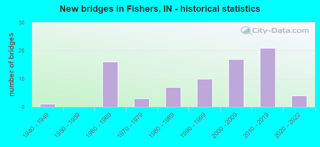
- New bridges - historical statistics
- 11940-1949
- 161960-1969
- 31970-1979
- 71980-1989
- 101990-1999
- 172000-2009
- 212010-2019
- 42020-2022
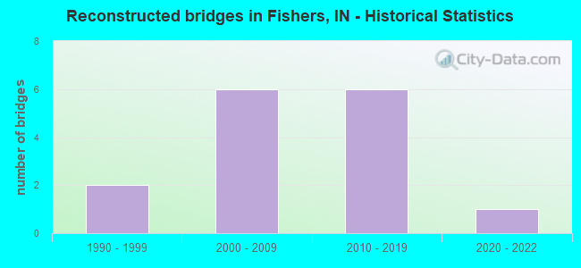
- Reconstructed bridges - Historical Statistics
- 21990-1999
- 62000-2009
- 62010-2019
- 12020-2022
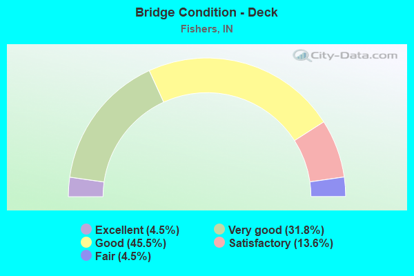
- Bridge Condition - Deck
- 4.5%Excellent
- 31.8%Very good
- 45.5%Good
- 13.6%Satisfactory
- 4.5%Fair
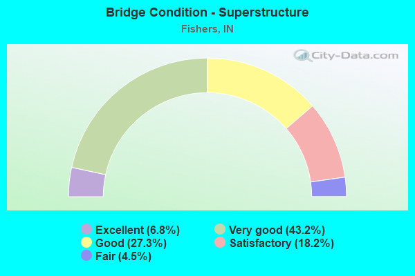
- Bridge Condition - Superstructure
- 6.8%Excellent
- 43.2%Very good
- 27.3%Good
- 18.2%Satisfactory
- 4.5%Fair
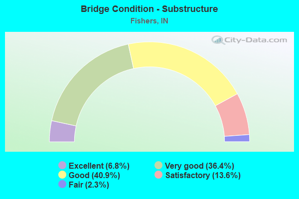
- Bridge Condition - Substructure
- 6.8%Excellent
- 36.4%Very good
- 40.9%Good
- 13.6%Satisfactory
- 2.3%Fair
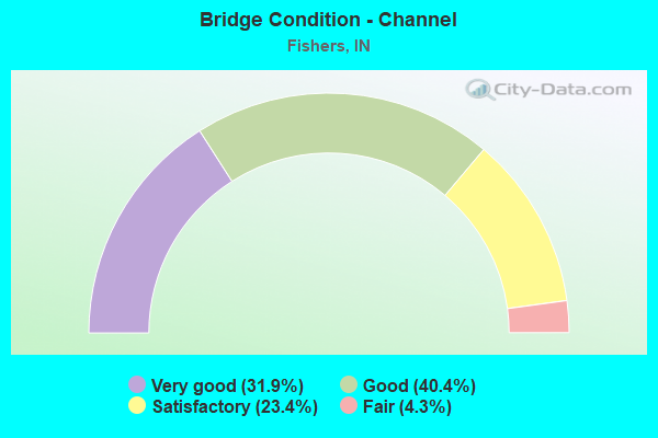
- Bridge Condition - Channel
- 31.9%Very good
- 40.4%Good
- 23.4%Satisfactory
- 4.3%Fair
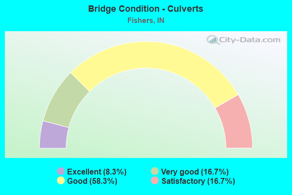
- Bridge Condition - Culverts
- 8.3%Excellent
- 16.7%Very good
- 58.3%Good
- 16.7%Satisfactory
Find on map >> Show street view
Structure Number: 2900238, Location: 00.12 S of 116th St (Lat: 39.955750, Lng: -85.974919), Route carried "on" structure: City street , Year Built: 1995, Status: Open, Structure Length: 1.59m (5.22ft), Average Daily Traffic: 300 (year 2017), Truck Traffic: 2%, Average Future Daily Traffic: 560 (year 2037), Design Load: HS 20, Features Intersected: PEPPERMILL POND, Facility Carried by Structure: PEPPERMILL LN
Minimum Vertical Clearance: 30+ m (98+ ft), Kilometerpoint: 0.000, Lanes on structure: 2, Owner: County Highway Agency, Approaching Roadway Width: 6.7m (22.0ft), Material/Design: Prestressed concrete, Design/Construction: Box Beam or Girders - Multiple, Number Of Spans In Main Unit: 1, Length of Maximum Span: 14.3m (46.9ft), Curb or Sidewalk Widths: Left: 1.5m (4.9ft), Right: 1.5m (4.9ft), Curb-To-Curb Width: 8.0m (26.2ft), Out-to-Out Width: 11.1m (36.4ft)
Condition: Deck: Very good, Superstructure: Very good, Substructure: Good, Channel: Very good, Operating Rating: 57.3 metric tons, Method Used To Determine Operating Rating: Load and Resistance Factor Rating (LRFR) rating reported by rating factor(RF) method using HL-93 loadings, Inventory Rating: 44.4 metric tons, Method Used To Determine Inventory Rating: Load and Resistance Factor Rating (LRFR) rating reported by rating factor(RF) method using HL-93 loadings, Structural Evaluation: Better than present minimum criteria, Deck Geometry: Somewhat better than minimum adequacy, Waterway Adequacy: Better than present minimum criteria, Approach Roadway Alignment: Equal to present minimum criteria, Designated Inspection Frequency: Every 24 months, Inspection Date: October 2021, Deck Structure Type: Concrete Cast-file-Place, Wearing Surface/Protective System: Wearing Surface: Monolithic Concrete, Deck Protection: Epoxy Coated Reinforcing
Find on map >> Show street view
Structure Number: 2900264, Location: 00.14 W of Eller Rd (Lat: 39.955361, Lng: -86.062711), Route carried "on" structure: City street , Year Built: 1998, Status: Open, Structure Length: 1.10m (3.61ft), Average Daily Traffic: 28,550 (year 2017), Truck Traffic: 5%, Average Future Daily Traffic: 52,820 (year 2037), Features Intersected: WHITE RIVER OVERFLOW, Facility Carried by Structure: 116TH ST EAST
Minimum Vertical Clearance: 30+ m (98+ ft), Kilometerpoint: 0.000, Lanes on structure: 4, Owner: County Highway Agency, Approaching Roadway Width: 16.5m (54.1ft), Skew: 20 degrees, Material/Design: Steel, Design/Construction: Culvert, Number Of Spans In Main Unit: 3, Length of Maximum Span: 3.0m (9.8ft), Curb-To-Curb Width: 14.6m (47.9ft), Out-to-Out Width: 16.5m (54.1ft)
Condition: Channel: Very good, Culverts: Good, Operating Rating: 58.3 metric tons, Method Used To Determine Operating Rating: Load and Resistance Factor Rating (LRFR) rating reported by rating factor(RF) method using HL-93 loadings, Inventory Rating: 45.0 metric tons, Method Used To Determine Inventory Rating: Load and Resistance Factor Rating (LRFR) rating reported by rating factor(RF) method using HL-93 loadings, Structural Evaluation: Better than present minimum criteria, Deck Geometry: High priority of replacement, Waterway Adequacy: Better than present minimum criteria, Approach Roadway Alignment: Equal to present desirable criteria, Designated Inspection Frequency: Every 24 months, Inspection Date: August 2021
Find on map >> Show street view
Structure Number: 290028, Location: 00.39 S of 226th St (Lat: 40.110500, Lng: -86.061600), Route carried "on" structure: County highway , Year Built: 2003, Status: Open, Structure Length: 0.67m (2.20ft), Average Daily Traffic: 1,180 (year 2017), Truck Traffic: 3%, Average Future Daily Traffic: 2,180 (year 2037), Design Load: HS 20, Features Intersected: JH LEAP DITCH, Facility Carried by Structure: MILL CREEK RD
Minimum Vertical Clearance: 30+ m (98+ ft), Kilometerpoint: 0.000, Lanes on structure: 2, Owner: County Highway Agency, Approaching Roadway Width: 9.8m (32.2ft), Skew: 4 degrees, Material/Design: Concrete, Design/Construction: Culvert, Number Of Spans In Main Unit: 1, Length of Maximum Span: 6.1m (20.0ft), Curb-To-Curb Width: 9.8m (32.2ft), Out-to-Out Width: 9.8m (32.2ft)
Condition: Channel: Very good, Culverts: Good, Operating Rating: 42.3 metric tons, Method Used To Determine Operating Rating: Field evaluation and documented engineering judgment, Inventory Rating: 32.7 metric tons, Method Used To Determine Inventory Rating: Field evaluation and documented engineering judgment, Structural Evaluation: Better than present minimum criteria, Deck Geometry: Somewhat better than minimum adequacy, Waterway Adequacy: Equal to present desirable criteria, Approach Roadway Alignment: Equal to present desirable criteria, Designated Inspection Frequency: Every 24 months, Inspection Date: September 2021
Find on map >> Show street view
Structure Number: 2900289, Location: 00.42 S of 126th St (Lat: 39.966281, Lng: -85.929519), Route carried "on" structure: City street , Year Built: 2003, Status: Open, Structure Length: 1.52m (4.99ft), Average Daily Traffic: 260 (year 2017), Truck Traffic: 3%, Average Future Daily Traffic: 480 (year 2037), Design Load: HS 20, Features Intersected: MUD CREEK, Facility Carried by Structure: GRAY EAGLE DR
Minimum Vertical Clearance: 30+ m (98+ ft), Kilometerpoint: 0.000, Lanes on structure: 2, Owner: County Highway Agency, Approaching Roadway Width: 9.8m (32.2ft), Skew: 2 degrees, Material/Design: Concrete, Design/Construction: Culvert, Number Of Spans In Main Unit: 1, Length of Maximum Span: 14.6m (47.9ft), Curb-To-Curb Width: 9.8m (32.2ft), Out-to-Out Width: 9.8m (32.2ft)
Condition: Channel: Very good, Culverts: Very good, Operating Rating: 42.3 metric tons, Method Used To Determine Operating Rating: Field evaluation and documented engineering judgment, Inventory Rating: 32.7 metric tons, Method Used To Determine Inventory Rating: Field evaluation and documented engineering judgment, Structural Evaluation: Equal to present desirable criteria, Deck Geometry: Better than present minimum criteria, Waterway Adequacy: Equal to present desirable criteria, Approach Roadway Alignment: Equal to present minimum criteria, Designated Inspection Frequency: Every 24 months, Inspection Date: September 2021
Find on map >> Show street view
Structure Number: 2900307, Location: 00.16 W of Allisonville R (Lat: 39.927000, Lng: -86.068719), Route carried "on" structure: City street , Year Built: 2000, Status: Open, Structure Length: 0.67m (2.20ft), Average Daily Traffic: 50,460 (year 2017), Truck Traffic: 2%, Average Future Daily Traffic: 93,350 (year 2037), Design Load: HS 20, Features Intersected: BEHNER BROOK, Facility Carried by Structure: 96TH ST EAST
Minimum Vertical Clearance: 30+ m (98+ ft), Kilometerpoint: 0.000, Lanes on structure: 8, Owner: County Highway Agency, Approaching Roadway Width: 27.4m (89.9ft), Skew: 24 degrees, Material/Design: Concrete, Design/Construction: Culvert, Number Of Spans In Main Unit: 2, Length of Maximum Span: 3.7m (12.1ft), Curb-To-Curb Width: 29.9m (98.1ft), Out-to-Out Width: 29.9m (98.1ft)
Condition: Channel: Good, Culverts: Satisfactory, Operating Rating: 42.3 metric tons, Method Used To Determine Operating Rating: Field evaluation and documented engineering judgment, Inventory Rating: 32.7 metric tons, Method Used To Determine Inventory Rating: Field evaluation and documented engineering judgment, Structural Evaluation: Equal to present minimum criteria, Deck Geometry: Meets minimum limits, Waterway Adequacy: Better than present minimum criteria, Approach Roadway Alignment: Equal to present desirable criteria, Designated Inspection Frequency: Every 24 months, Inspection Date: September 2021
Find on map >> Show street view
Structure Number: 2900314, Location: 00.50 W of SR 37 (Lat: 39.977781, Lng: -86.009881), Route carried "on" structure: City street , Year Built: 2006, Status: Open, Structure Length: 2.77m (9.09ft), Average Daily Traffic: 690 (year 2017), Truck Traffic: 1%, Average Future Daily Traffic: 1,280 (year 2037), Design Load: HS 20, Features Intersected: SHOEMAKER DITCH, Facility Carried by Structure: MAYS LANDING DR
Minimum Vertical Clearance: 30+ m (98+ ft), Kilometerpoint: 0.000, Lanes on structure: 2, Owner: County Highway Agency, Approaching Roadway Width: 8.8m (28.9ft), Material/Design: Concrete, Design/Construction: Culvert, Number Of Spans In Main Unit: 3, Length of Maximum Span: 8.5m (27.9ft), Curb or Sidewalk Widths: Left: 2.4m (7.9ft), Right: 0.0m, Curb-To-Curb Width: 8.8m (28.9ft), Out-to-Out Width: 12.6m (41.3ft)
Condition: Channel: Good, Culverts: Good, Operating Rating: 42.3 metric tons, Method Used To Determine Operating Rating: Field evaluation and documented engineering judgment, Inventory Rating: 32.7 metric tons, Method Used To Determine Inventory Rating: Field evaluation and documented engineering judgment, Structural Evaluation: Better than present minimum criteria, Deck Geometry: Somewhat better than minimum adequacy, Waterway Adequacy: Equal to present desirable criteria, Approach Roadway Alignment: Equal to present minimum criteria, Designated Inspection Frequency: Every 24 months, Inspection Date: September 2021
Find on map >> Show street view
Structure Number: 290032, Location: 00.07 S of 146th St (Lat: 40.000381, Lng: -85.937889), Route carried "on" structure: City street , Year Built: 2007, Status: Open, Structure Length: 2.43m (7.97ft), Average Daily Traffic: 2,740 (year 2017), Truck Traffic: 2%, Average Future Daily Traffic: 5,070 (year 2037), Design Load: HS 25 or greater, Features Intersected: SAND CREEK, Facility Carried by Structure: BODEN RD
Minimum Vertical Clearance: 30+ m (98+ ft), Kilometerpoint: 0.000, Lanes on structure: 5, Owner: County Highway Agency, Approaching Roadway Width: 20.1m (65.9ft), Skew: 22 degrees, Material/Design: Prestressed concrete, Design/Construction: Box Beam or Girders - Single/Spread, Number Of Spans In Main Unit: 1, Length of Maximum Span: 23.5m (77.1ft), Curb or Sidewalk Widths: Left: 2.1m (6.9ft), Right: 3.3m (10.8ft), Curb-To-Curb Width: 20.1m (65.9ft), Out-to-Out Width: 26.8m (87.9ft)
Condition: Deck: Good, Superstructure: Satisfactory, Substructure: Good, Channel: Satisfactory, Operating Rating: 55.1 metric tons, Method Used To Determine Operating Rating: Load and Resistance Factor Rating (LRFR) rating reported by rating factor(RF) method using HL-93 loadings, Inventory Rating: 42.4 metric tons, Method Used To Determine Inventory Rating: Load and Resistance Factor Rating (LRFR) rating reported by rating factor(RF) method using HL-93 loadings, Structural Evaluation: Equal to present minimum criteria, Deck Geometry: Somewhat better than minimum adequacy, Waterway Adequacy: Equal to present desirable criteria, Approach Roadway Alignment: Equal to present minimum criteria, Designated Inspection Frequency: Every 24 months, Inspection Date: September 2021, Deck Structure Type: Concrete Cast-file-Place, Wearing Surface/Protective System: Wearing Surface: Monolithic Concrete, Deck Protection: Epoxy Coated Reinforcing
Find on map >> Show street view
Structure Number: 2900322, Location: 00.22 N of 131st St (Lat: 39.982089, Lng: -86.000561), Route carried "on" structure: County highway , Year Built: 2007, Status: Open, Structure Length: 1.40m (4.59ft), Average Daily Traffic: 490 (year 2017), Truck Traffic: 1%, Average Future Daily Traffic: 910 (year 2037), Design Load: HS 20, Features Intersected: BRITTON BRANCH, Facility Carried by Structure: PARKSIDE DR
Minimum Vertical Clearance: 30+ m (98+ ft), Kilometerpoint: 0.000, Lanes on structure: 2, Owner: County Highway Agency, Approaching Roadway Width: 12.2m (40.0ft), Skew: 20 degrees, Material/Design: Concrete, Design/Construction: Culvert, Number Of Spans In Main Unit: 1, Length of Maximum Span: 12.8m (42.0ft), Curb-To-Curb Width: 12.2m (40.0ft), Out-to-Out Width: 22.9m (75.1ft)
Condition: Channel: Very good, Culverts: Good, Operating Rating: 42.3 metric tons, Method Used To Determine Operating Rating: Field evaluation and documented engineering judgment, Inventory Rating: 32.7 metric tons, Method Used To Determine Inventory Rating: Field evaluation and documented engineering judgment, Structural Evaluation: Better than present minimum criteria, Deck Geometry: Equal to present desirable criteria, Waterway Adequacy: Equal to present desirable criteria, Approach Roadway Alignment: Equal to present minimum criteria, Designated Inspection Frequency: Every 24 months, Inspection Date: September 2021
Find on map >> Show street view
Structure Number: 2900327, Location: 00.32 N of 106th St (Lat: 39.946211, Lng: -85.994961), Route carried "on" structure: City street , Year Built: 2015, Status: Open, Structure Length: 1.61m (5.28ft), Average Daily Traffic: 15,340 (year 2017), Truck Traffic: 4%, Average Future Daily Traffic: 28,380 (year 2037), Design Load: HL 93, Features Intersected: SAND CREEK, Facility Carried by Structure: CUMBERLAND RD
Minimum Vertical Clearance: 30+ m (98+ ft), Kilometerpoint: 0.000, Lanes on structure: 2, Owner: County Highway Agency, Approaching Roadway Width: 9.8m (32.2ft), Skew: 1 degrees, Material/Design: Concrete, Design/Construction: Culvert, Number Of Spans In Main Unit: 1, Length of Maximum Span: 15.5m (50.9ft), Curb or Sidewalk Widths: Left: 2.6m (8.5ft), Right: 0.0m, Curb-To-Curb Width: 10.4m (34.1ft), Out-to-Out Width: 19.2m (63.0ft)
Condition: Channel: Good, Culverts: Good, Operating Rating: 42.3 metric tons, Method Used To Determine Operating Rating: Field evaluation and documented engineering judgment, Inventory Rating: 32.7 metric tons, Method Used To Determine Inventory Rating: Field evaluation and documented engineering judgment, Structural Evaluation: Better than present minimum criteria, Deck Geometry: Meets minimum limits, Waterway Adequacy: Equal to present minimum criteria, Approach Roadway Alignment: Equal to present minimum criteria, Designated Inspection Frequency: Every 24 months, Inspection Date: September 2021
Find on map >> Show street view
Structure Number: 2900441, Location: 00.41 E of Cyntheanne Rd (Lat: 39.936100, Lng: -85.873539), Route carried "on" structure: County highway , Year Built: 2009, Status: Open, Structure Length: 2.77m (9.09ft), Average Daily Traffic: 790 (year 2017), Truck Traffic: 3%, Average Future Daily Traffic: 1,460 (year 2037), Design Load: HS 25 or greater, Features Intersected: FLATFORK CREEK, Facility Carried by Structure: 101ST ST EAST
Minimum Vertical Clearance: 30+ m (98+ ft), Kilometerpoint: 0.000, Lanes on structure: 2, Owner: County Highway Agency, Approaching Roadway Width: 8.5m (27.9ft), Material/Design: Prestressed concrete, Design/Construction: Stringer/Multi-beam, Number Of Spans In Main Unit: 1, Length of Maximum Span: 26.8m (87.9ft), Curb or Sidewalk Widths: Left: 0.0m, Right: 2.5m (8.2ft), Curb-To-Curb Width: 9.1m (29.9ft), Out-to-Out Width: 12.3m (40.4ft)
Condition: Deck: Very good, Superstructure: Very good, Substructure: Good, Channel: Good, Operating Rating: 56.1 metric tons, Method Used To Determine Operating Rating: Load and Resistance Factor Rating (LRFR) rating reported by rating factor(RF) method using HL-93 loadings, Inventory Rating: 43.4 metric tons, Method Used To Determine Inventory Rating: Load and Resistance Factor Rating (LRFR) rating reported by rating factor(RF) method using HL-93 loadings, Structural Evaluation: Better than present minimum criteria, Deck Geometry: Equal to present minimum criteria, Waterway Adequacy: Equal to present desirable criteria, Approach Roadway Alignment: Equal to present desirable criteria, Designated Inspection Frequency: Every 24 months, Inspection Date: September 2021, Deck Structure Type: Concrete Cast-file-Place, Wearing Surface/Protective System: Wearing Surface: Monolithic Concrete, Deck Protection: Epoxy Coated Reinforcing
Find on map >> Show street view
Structure Number: 2900455, Location: 00.40 S OF E 136TH STREET (Lat: 39.984150, Lng: -85.908119), Route carried "on" structure: County highway , Year Built: 2009, Status: Open, Structure Length: 2.64m (8.66ft), Average Daily Traffic: 7,890 (year 2017), Truck Traffic: 11%, Average Future Daily Traffic: 14,600 (year 2037), Design Load: HS 20, Features Intersected: MUD CREEK, Facility Carried by Structure: SOUTHEASTERN PKWY.
Minimum Vertical Clearance: 30+ m (98+ ft), Kilometerpoint: 0.000, Lanes on structure: 2, Owner: County Highway Agency, Approaching Roadway Width: 7.3m (24.0ft), Material/Design: Prestressed concrete, Design/Construction: Box Beam or Girders - Single/Spread, Number Of Spans In Main Unit: 1, Length of Maximum Span: 24.8m (81.4ft), Curb-To-Curb Width: 11.2m (36.7ft), Out-to-Out Width: 12.1m (39.7ft)
Condition: Deck: Very good, Superstructure: Very good, Substructure: Very good, Channel: Good, Operating Rating: 50.2 metric tons, Method Used To Determine Operating Rating: Load and Resistance Factor Rating (LRFR) rating reported by rating factor(RF) method using HL-93 loadings, Inventory Rating: 38.6 metric tons, Method Used To Determine Inventory Rating: Load and Resistance Factor Rating (LRFR) rating reported by rating factor(RF) method using HL-93 loadings, Structural Evaluation: Equal to present desirable criteria, Deck Geometry: Meets minimum limits, Waterway Adequacy: Equal to present desirable criteria, Approach Roadway Alignment: Equal to present desirable criteria, Designated Inspection Frequency: Every 24 months, Inspection Date: September 2021, Deck Structure Type: Concrete Cast-file-Place, Wearing Surface/Protective System: Wearing Surface: Monolithic Concrete, Deck Protection: Epoxy Coated Reinforcing
Find on map >> Show street view
Structure Number: 2900456, Location: 00.22 S OF 126TH STREET (Lat: 39.971189, Lng: -85.890269), Route carried "on" structure: County highway , Year Built: 2009, Status: Open, Structure Length: 2.08m (6.82ft), Average Daily Traffic: 8,590 (year 2017), Truck Traffic: 11%, Average Future Daily Traffic: 15,890 (year 2037), Design Load: HS 20, Features Intersected: THORPE CREEK, Facility Carried by Structure: SOUTHEASTERN PKWY.
Minimum Vertical Clearance: 30+ m (98+ ft), Kilometerpoint: 0.000, Lanes on structure: 2, Owner: County Highway Agency, Approaching Roadway Width: 7.3m (24.0ft), Material/Design: Prestressed concrete, Design/Construction: Box Beam or Girders - Single/Spread, Number Of Spans In Main Unit: 1, Length of Maximum Span: 19.4m (63.6ft), Curb-To-Curb Width: 11.2m (36.7ft), Out-to-Out Width: 12.1m (39.7ft)
Condition: Deck: Very good, Superstructure: Very good, Substructure: Very good, Channel: Good, Operating Rating: 39.5 metric tons, Method Used To Determine Operating Rating: Load and Resistance Factor Rating (LRFR) rating reported by rating factor(RF) method using HL-93 loadings, Inventory Rating: 30.5 metric tons, Method Used To Determine Inventory Rating: Load and Resistance Factor Rating (LRFR) rating reported by rating factor(RF) method using HL-93 loadings, Structural Evaluation: Better than present minimum criteria, Deck Geometry: Meets minimum limits, Waterway Adequacy: Equal to present desirable criteria, Approach Roadway Alignment: Equal to present minimum criteria, Designated Inspection Frequency: Every 24 months, Inspection Date: September 2021, Deck Structure Type: Concrete Cast-file-Place, Wearing Surface/Protective System: Wearing Surface: Monolithic Concrete, Deck Protection: Epoxy Coated Reinforcing
Find on map >> Show street view
Structure Number: 2900457, Location: 00.04 S OF ATLANTIC AVE. (Lat: 39.954500, Lng: -85.867081), Route carried "on" structure: County highway , Year Built: 1970, Year Reconstructed: 2009, Status: Open, Structure Length: 6.53m (21.42ft), Average Daily Traffic: 370 (year 2017), Truck Traffic: 11%, Average Future Daily Traffic: 680 (year 2037), Design Load: HS 20, Features Intersected: FALL CREEK, Facility Carried by Structure: SOUTHEASTERN PKWY.
Minimum Vertical Clearance: 30+ m (98+ ft), Kilometerpoint: 0.000, Lanes on structure: 2, Owner: County Highway Agency, Approaching Roadway Width: 7.3m (24.0ft), Material/Design: Prestressed concrete continuous, Design/Construction: Stringer/Multi-beam, Number Of Spans In Main Unit: 3, Length of Maximum Span: 21.8m (71.5ft), Curb-To-Curb Width: 13.7m (44.9ft), Out-to-Out Width: 14.3m (46.9ft)
Condition: Deck: Satisfactory, Superstructure: Satisfactory, Substructure: Good, Channel: Satisfactory, Operating Rating: 24.3 metric tons, Method Used To Determine Operating Rating: Load and Resistance Factor Rating (LRFR) rating reported by rating factor(RF) method using HL-93 loadings, Inventory Rating: 18.8 metric tons, Method Used To Determine Inventory Rating: Load and Resistance Factor Rating (LRFR) rating reported by rating factor(RF) method using HL-93 loadings, Structural Evaluation: Somewhat better than minimum adequacy, Deck Geometry: Superior to present desirable criteria, Waterway Adequacy: Equal to present desirable criteria, Approach Roadway Alignment: Equal to present minimum criteria, Designated Inspection Frequency: Every 24 months, Inspection Date: September 2021, Deck Structure Type: Concrete Cast-file-Place, Wearing Surface/Protective System: Wearing Surface: Monolithic Concrete, Deck Protection: Epoxy Coated Reinforcing
Find on map >> Show street view
Structure Number: 2900464, Location: 00.23 E of Pennington Rd (Lat: 39.972469, Lng: -85.923931), Route carried "on" structure: City street , Year Built: 2010, Status: Open, Structure Length: 3.63m (11.91ft), Average Daily Traffic: 4,550 (year 2017), Truck Traffic: 3%, Average Future Daily Traffic: 8,420 (year 2037), Design Load: HS 25 or greater, Features Intersected: MUD CREEK, Facility Carried by Structure: 126TH ST EAST
Minimum Vertical Clearance: 30+ m (98+ ft), Kilometerpoint: 0.000, Lanes on structure: 4, Owner: County Highway Agency, Approaching Roadway Width: 17.1m (56.1ft), Skew: 23 degrees, Material/Design: Prestressed concrete continuous, Design/Construction: Box Beam or Girders - Single/Spread, Number Of Spans In Main Unit: 3, Length of Maximum Span: 12.3m (40.4ft), Curb or Sidewalk Widths: Left: 3.0m (9.8ft), Right: 1.8m (5.9ft), Curb-To-Curb Width: 17.1m (56.1ft), Out-to-Out Width: 24.9m (81.7ft)
Condition: Deck: Good, Superstructure: Very good, Substructure: Very good, Channel: Satisfactory, Operating Rating: 72.6 metric tons, Method Used To Determine Operating Rating: Load and Resistance Factor Rating (LRFR) rating reported by rating factor(RF) method using HL-93 loadings, Inventory Rating: 56.1 metric tons, Method Used To Determine Inventory Rating: Load and Resistance Factor Rating (LRFR) rating reported by rating factor(RF) method using HL-93 loadings, Structural Evaluation: Equal to present desirable criteria, Deck Geometry: Somewhat better than minimum adequacy, Waterway Adequacy: Equal to present desirable criteria, Approach Roadway Alignment: Equal to present desirable criteria, Designated Inspection Frequency: Every 24 months, Inspection Date: September 2021, Deck Structure Type: Concrete Cast-file-Place, Wearing Surface/Protective System: Wearing Surface: Monolithic Concrete, Deck Protection: Epoxy Coated Reinforcing
Find on map >> Show street view
Structure Number: 2900467, Location: 01.05 E OF CUMBERLAND ROA (Lat: 39.971869, Lng: -85.974331), Route carried "on" structure: City street , Year Built: 2011, Status: Open, Structure Length: 2.91m (9.55ft), Average Daily Traffic: 4,550 (year 2017), Truck Traffic: 2%, Average Future Daily Traffic: 8,420 (year 2037), Design Load: HS 25 or greater, Features Intersected: SAND CREEK, Facility Carried by Structure: 126TH ST EB/WB
Minimum Vertical Clearance: 30+ m (98+ ft), Kilometerpoint: 0.000, Lanes on structure: 4, Owner: County Highway Agency, Approaching Roadway Width: 17.1m (56.1ft), Skew: 21 degrees, Material/Design: Concrete continuous, Design/Construction: Slab, Number Of Spans In Main Unit: 3, Length of Maximum Span: 10.8m (35.4ft), Curb or Sidewalk Widths: Left: 3.0m (9.8ft), Right: 1.8m (5.9ft), Curb-To-Curb Width: 17.1m (56.1ft), Out-to-Out Width: 24.9m (81.7ft)
Condition: Deck: Very good, Superstructure: Very good, Substructure: Good, Channel: Very good, Operating Rating: 60.6 metric tons, Method Used To Determine Operating Rating: Load and Resistance Factor Rating (LRFR) rating reported by rating factor(RF) method using HL-93 loadings, Inventory Rating: 47.0 metric tons, Method Used To Determine Inventory Rating: Load and Resistance Factor Rating (LRFR) rating reported by rating factor(RF) method using HL-93 loadings, Structural Evaluation: Better than present minimum criteria, Deck Geometry: Somewhat better than minimum adequacy, Waterway Adequacy: Equal to present desirable criteria, Approach Roadway Alignment: Equal to present desirable criteria, Designated Inspection Frequency: Every 24 months, Inspection Date: October 2021, Deck Structure Type: Concrete Cast-file-Place, Wearing Surface/Protective System: Wearing Surface: Monolithic Concrete, Deck Protection: Epoxy Coated Reinforcing
Find on map >> Show street view
Structure Number: 2900471, Location: 00.07 E WESTFIELD BLVD (Lat: 40.022050, Lng: -86.126281), Route carried "on" structure: City street 42, Year Built: 2013, Status: Open, Structure Length: 1.32m (4.33ft), Average Daily Traffic: 5,750 (year 2017), Truck Traffic: 5%, Average Future Daily Traffic: 10,640 (year 2037), Design Load: HL 93, Features Intersected: COOL CREEK, Facility Carried by Structure: 161ST ST EAST
Minimum Vertical Clearance: 30+ m (98+ ft), Kilometerpoint: 0.000, Lanes on structure: 2, Owner: County Highway Agency, Approaching Roadway Width: 8.5m (27.9ft), Skew: 2 degrees, Material/Design: Concrete, Design/Construction: Culvert, Number Of Spans In Main Unit: 1, Length of Maximum Span: 12.6m (41.3ft), Curb or Sidewalk Widths: Left: 0.0m, Right: 3.2m (10.5ft), Curb-To-Curb Width: 9.1m (29.9ft), Out-to-Out Width: 9.1m (29.9ft)
Condition: Channel: Good, Culverts: Good, Operating Rating: 42.3 metric tons, Method Used To Determine Operating Rating: Field evaluation and documented engineering judgment, Inventory Rating: 32.7 metric tons, Method Used To Determine Inventory Rating: Field evaluation and documented engineering judgment, Structural Evaluation: Better than present minimum criteria, Deck Geometry: High priority of corrective action, Waterway Adequacy: Equal to present desirable criteria, Approach Roadway Alignment: Equal to present minimum criteria, Designated Inspection Frequency: Every 24 months, Inspection Date: September 2021
Find on map >> Show street view
Structure Number: 2900479, Location: 00.09 E of Allisonville R (Lat: 39.941600, Lng: -86.047289), Route carried "on" structure: City street , Year Built: 2016, Status: Open, Structure Length: 1.16m (3.81ft), Average Daily Traffic: 13,930 (year 2017), Truck Traffic: 8%, Average Future Daily Traffic: 25,770 (year 2037), Design Load: HL 93, Features Intersected: CHEENEY CREEK, Facility Carried by Structure: 106TH ST EAST
Minimum Vertical Clearance: 30+ m (98+ ft), Kilometerpoint: 0.000, Lanes on structure: 3, Owner: County Highway Agency, Approaching Roadway Width: 12.2m (40.0ft), Skew: 3 degrees, Material/Design: Concrete, Design/Construction: Slab, Number Of Spans In Main Unit: 1, Length of Maximum Span: 10.1m (33.1ft), Curb or Sidewalk Widths: Left: 0.0m, Right: 3.4m (11.2ft), Curb-To-Curb Width: 12.9m (42.3ft), Out-to-Out Width: 16.9m (55.4ft)
Condition: Deck: Good, Superstructure: Good, Substructure: Very good, Channel: Very good, Operating Rating: 36.0 metric tons, Method Used To Determine Operating Rating: Load and Resistance Factor Rating (LRFR) rating reported by rating factor(RF) method using HL-93 loadings, Inventory Rating: 27.5 metric tons, Method Used To Determine Inventory Rating: Load and Resistance Factor Rating (LRFR) rating reported by rating factor(RF) method using HL-93 loadings, Structural Evaluation: Equal to present minimum criteria, Deck Geometry: Meets minimum limits, Waterway Adequacy: Equal to present desirable criteria, Approach Roadway Alignment: Equal to present minimum criteria, Designated Inspection Frequency: Every 24 months, Inspection Date: September 2021, Deck Structure Type: Concrete Cast-file-Place, Wearing Surface/Protective System: Wearing Surface: Monolithic Concrete, Deck Protection: Epoxy Coated Reinforcing
Find on map >> Show street view
Structure Number: 2900494, Location: 00.06 N 126TH ST (Lat: 39.972089, Lng: -86.034439), Route carried "on" structure: City street , Year Built: 2018, Status: Open, Structure Length: 1.22m (4.00ft), Average Daily Traffic: 28,210 (year 2017), Truck Traffic: 7%, Average Future Daily Traffic: 52,190 (year 2037), Design Load: HS 20, Features Intersected: SHOEMAKER DITCH, Facility Carried by Structure: ALLISONVILLE RD
Minimum Vertical Clearance: 30+ m (98+ ft), Kilometerpoint: 0.000, Lanes on structure: 5, Owner: County Highway Agency, Approaching Roadway Width: 19.2m (63.0ft), Skew: 1 degrees, Material/Design: Concrete, Design/Construction: Culvert, Number Of Spans In Main Unit: 1, Length of Maximum Span: 12.2m (40.0ft), Curb or Sidewalk Widths: Left: 3.0m (9.8ft), Right: 3.0m (9.8ft), Curb-To-Curb Width: 19.2m (63.0ft), Out-to-Out Width: 35.7m (117.1ft)
Condition: Channel: Very good, Culverts: Very good, Operating Rating: 42.3 metric tons, Method Used To Determine Operating Rating: Field evaluation and documented engineering judgment, Inventory Rating: 32.7 metric tons, Method Used To Determine Inventory Rating: Field evaluation and documented engineering judgment, Structural Evaluation: Equal to present desirable criteria, Deck Geometry: Meets minimum limits, Waterway Adequacy: Equal to present minimum criteria, Approach Roadway Alignment: Equal to present desirable criteria, Designated Inspection Frequency: Every 24 months, Inspection Date: October 2021
Find on map >> Show street view
Structure Number: 2900506, Location: 0.80 MI W OF I-69 (Lat: 39.956181, Lng: -86.016119), Route carried "on" structure: County highway , Year Built: 2021, Status: Open, Structure Length: 0.67m (2.20ft), Average Daily Traffic: 27,800 (year 2019), Truck Traffic: 2%, Average Future Daily Traffic: 50,040 (year 2039), Design Load: HL 93, Features Intersected: NICKEL PLATE TRAIL, Facility Carried by Structure: 116TH STREET
Minimum Vertical Clearance: 30+ m (98+ ft), Kilometerpoint: 0.000, Lanes on structure: 4, Owner: City or Municipal Highway Agency, Approaching Roadway Width: 20.7m (67.9ft), Skew: 2 degrees, Material/Design: Concrete, Design/Construction: Culvert, Number Of Spans In Main Unit: 1, Length of Maximum Span: 6.1m (20.0ft), Curb or Sidewalk Widths: Left: 0.0m, Right: 4.9m (16.1ft), Curb-To-Curb Width: 20.7m (67.9ft), Out-to-Out Width: 36.0m (118.1ft)
Condition: Culverts: Excellent, Operating Rating: 41.1 metric tons, Method Used To Determine Operating Rating: Load and Resistance Factor Rating (LRFR) rating reported by rating factor(RF) method using HL-93 loadings, Inventory Rating: 31.8 metric tons, Method Used To Determine Inventory Rating: Load and Resistance Factor Rating (LRFR) rating reported by rating factor(RF) method using HL-93 loadings, Structural Evaluation: Better than present minimum criteria, Deck Geometry: Equal to present minimum criteria, Approach Roadway Alignment: Equal to present desirable criteria, Designated Inspection Frequency: Every 24 months, Inspection Date: November 2021
Find on map >> Show street view
Structure Number: 12471, Location: 04.13 S SR 238 (Lat: 39.963600, Lng: -86.002931), Route carried "under" structure: Interstate 69, Year Built: 2013, Structure Length: 0. m, Average Daily Traffic: 31,545 (year 2013), Truck Traffic: 18%, Features Intersected: I-69 NB, Facility Carried by Structure: SR 37 NB
Minimum Vertical Clearance: 5.76m (18.90ft), Kilometerpoint: 8.787, Lanes on structure: 2, Lanes under structure: 2, Material/Design: Steel continuous, Design/Construction: Stringer/Multi-beam, Length of Maximum Span: 52.1m (170.9ft)
Find on map >> Show street view
Structure Number: 12471, Location: 04.13 S SR 238 (Lat: 39.963600, Lng: -86.002931), Route carried "under" structure: Interstate 69, Year Built: 2013, Structure Length: 0. m, Average Daily Traffic: 31,545 (year 2013), Truck Traffic: 18%, Features Intersected: I-69 SB, Facility Carried by Structure: SR 37 NB
Minimum Vertical Clearance: 5.76m (18.90ft), Kilometerpoint: 8.787, Lanes on structure: 2, Lanes under structure: 2, Material/Design: Steel continuous, Design/Construction: Stringer/Multi-beam, Length of Maximum Span: 52.1m (170.9ft)
Find on map >> Show street view
Structure Number: 12471, Location: 04.13 S SR 238 (Lat: 39.963600, Lng: -86.002931), Route carried "under" structure: Ramp Interstate 69, Year Built: 2013, Structure Length: 0. m, Average Daily Traffic: 3,914 (year 2013), Truck Traffic: 51%, Features Intersected: 116TH ST RAMP, Facility Carried by Structure: SR 37 NB
Minimum Vertical Clearance: 5.43m (17.81ft), Kilometerpoint: 8.787, Lanes on structure: 2, Lanes under structure: 1, Material/Design: Steel continuous, Design/Construction: Stringer/Multi-beam, Length of Maximum Span: 52.1m (170.9ft)
Find on map >> Show street view
Structure Number: 3892, Location: 02.58 N I-465 (Lat: 39.927081, Lng: -86.029669), Route carried "under" structure: Interstate 69, Year Built: 1969, Structure Length: 0. m, Average Daily Traffic: 66,000 (year 2010), Truck Traffic: 7%, Features Intersected: I-69 NBL, Facility Carried by Structure: 96TH STREET
Minimum Vertical Clearance: 5.13m (16.83ft), Kilometerpoint: 326.021, Lanes on structure: 8, Lanes under structure: 7, Material/Design: Steel continuous, Design/Construction: Stringer/Multi-beam, Length of Maximum Span: 34.5m (113.2ft)
Find on map >> Show street view
Structure Number: 3892, Location: 02.58 N I-465 (Lat: 39.927081, Lng: -86.029669), Route carried "under" structure: Interstate 69, Year Built: 1969, Structure Length: 0. m, Average Daily Traffic: 66,000 (year 2010), Truck Traffic: 7%, Features Intersected: I-69 SBL, Facility Carried by Structure: 96TH STREET
Minimum Vertical Clearance: 5.08m (16.67ft), Kilometerpoint: 326.021, Lanes on structure: 8, Lanes under structure: 7, Material/Design: Steel continuous, Design/Construction: Stringer/Multi-beam, Length of Maximum Span: 34.5m (113.2ft)
Find on map >> Show street view
Structure Number: 38929, Location: 03.74 N I-465 (Lat: 39.941661, Lng: -86.018969), Route carried "under" structure: Interstate 69, Year Built: 2016, Structure Length: 0. m, Average Daily Traffic: 59,011 (year 2015), Truck Traffic: 8%, Features Intersected: I-69 NBL, Facility Carried by Structure: 106TH STREET EB
Minimum Vertical Clearance: 5.16m (16.93ft), Kilometerpoint: 327.856, Lanes on structure: 2, Lanes under structure: 10, Material/Design: Steel continuous, Design/Construction: Stringer/Multi-beam, Length of Maximum Span: 26.2m (86.0ft)
Find on map >> Show street view
Structure Number: 38929, Location: 03.74 N I-465 (Lat: 39.941661, Lng: -86.018969), Route carried "under" structure: Interstate 69, Year Built: 2016, Structure Length: 0. m, Average Daily Traffic: 59,011 (year 2015), Truck Traffic: 8%, Features Intersected: I-69 SBL, Facility Carried by Structure: 106TH STREET EB
Minimum Vertical Clearance: 5.16m (16.93ft), Kilometerpoint: 327.856, Lanes on structure: 2, Lanes under structure: 10, Material/Design: Steel continuous, Design/Construction: Stringer/Multi-beam, Length of Maximum Span: 26.2m (86.0ft)
Find on map >> Show street view
Structure Number: 38931, Location: 03.74 N I-465 (Lat: 39.942219, Lng: -86.018550), Route carried "under" structure: Interstate 69, Year Built: 2016, Structure Length: 0. m, Average Daily Traffic: 59,011 (year 2015), Truck Traffic: 8%, Features Intersected: I-69 SBL, Facility Carried by Structure: 106TH STREET WB
Minimum Vertical Clearance: 5.13m (16.83ft), Kilometerpoint: 327.888, Lanes on structure: 2, Lanes under structure: 10, Material/Design: Steel continuous, Design/Construction: Stringer/Multi-beam, Length of Maximum Span: 26.2m (86.0ft)
Find on map >> Show street view
Structure Number: 38931, Location: 03.74 N I-465 (Lat: 39.942219, Lng: -86.018550), Route carried "under" structure: Interstate 69, Year Built: 2016, Structure Length: 0. m, Average Daily Traffic: 59,011 (year 2015), Truck Traffic: 8%, Features Intersected: I-69 NBL, Facility Carried by Structure: 106TH STREET WB
Minimum Vertical Clearance: 5.13m (16.83ft), Kilometerpoint: 327.904, Lanes on structure: 2, Lanes under structure: 10, Material/Design: Steel continuous, Design/Construction: Stringer/Multi-beam, Length of Maximum Span: 26.2m (86.0ft)
Find on map >> Show street view
Structure Number: 3894, Location: 04.90 N I-465 (Lat: 39.956700, Lng: -86.007900), Route carried "under" structure: Interstate 69, Year Built: 1969, Structure Length: 0. m, Average Daily Traffic: 56,280 (year 2010), Truck Traffic: 10%, Features Intersected: I-69 NBL, Facility Carried by Structure: 116TH STREET
Minimum Vertical Clearance: 4.93m (16.17ft), Kilometerpoint: 329.755, Lanes on structure: 4, Lanes under structure: 9, Material/Design: Steel continuous, Design/Construction: Stringer/Multi-beam, Length of Maximum Span: 23.5m (77.1ft)
Find on map >> Show street view
Structure Number: 3894, Location: 04.90 N I-465 (Lat: 39.956969, Lng: -86.007911), Route carried "under" structure: Interstate 69, Year Built: 1969, Structure Length: 0. m, Average Daily Traffic: 56,280 (year 2010), Truck Traffic: 10%, Features Intersected: I-69 SBL, Facility Carried by Structure: 116TH STREET
Minimum Vertical Clearance: 4.93m (16.17ft), Kilometerpoint: 329.755, Lanes on structure: 4, Lanes under structure: 9, Material/Design: Steel continuous, Design/Construction: Stringer/Multi-beam, Length of Maximum Span: 23.5m (77.1ft)
Find on map >> Show street view
Structure Number: 3894, Location: 04.90 N I-465 (Lat: 39.956969, Lng: -86.008150), Route carried "under" structure: Ramp Interstate 69, Year Built: 1969, Structure Length: 0. m, Average Daily Traffic: 18,910 (year 2010), Truck Traffic: 16%, Features Intersected: I-69 SB CD, Facility Carried by Structure: 116TH STREET
Minimum Vertical Clearance: 5.01m (16.44ft), Kilometerpoint: 329.755, Lanes on structure: 4, Lanes under structure: 9, Material/Design: Steel continuous, Design/Construction: Stringer/Multi-beam, Length of Maximum Span: 23.5m (77.1ft)
Find on map >> Show street view
Structure Number: 3894, Location: 04.90 N I-465 (Lat: 39.956700, Lng: -86.007611), Route carried "under" structure: Ramp Interstate 69, Year Built: 1969, Structure Length: 0. m, Average Daily Traffic: 21,680 (year 2010), Truck Traffic: 7%, Features Intersected: I-69 NB CD, Facility Carried by Structure: 116TH STREET
Minimum Vertical Clearance: 4.95m (16.24ft), Kilometerpoint: 329.755, Lanes on structure: 4, Lanes under structure: 9, Material/Design: Steel continuous, Design/Construction: Stringer/Multi-beam, Length of Maximum Span: 23.5m (77.1ft)
Find on map >> Show street view
Structure Number: 3895, Location: 00.53 N SR 37 (Lat: 39.967300, Lng: -85.994169), Route carried "under" structure: Interstate 69, Year Built: 1969, Structure Length: 0. m, Average Daily Traffic: 30,360 (year 2006), Truck Traffic: 20%, Features Intersected: I-69 NBL, Facility Carried by Structure: CUMBERLAND ROAD
Minimum Vertical Clearance: 4.95m (16.24ft), Kilometerpoint: 331.509, Lanes on structure: 2, Lanes under structure: 5, Material/Design: Steel continuous, Design/Construction: Stringer/Multi-beam, Length of Maximum Span: 31.7m (104.0ft)
Find on map >> Show street view
Structure Number: 3895, Location: 00.53 N SR 37 (Lat: 39.967300, Lng: -85.994169), Route carried "under" structure: Interstate 69, Year Built: 1969, Structure Length: 0. m, Average Daily Traffic: 30,360 (year 2006), Truck Traffic: 20%, Features Intersected: I-69 SBL, Facility Carried by Structure: CUMBERLAND ROAD
Minimum Vertical Clearance: 4.85m (15.91ft), Kilometerpoint: 331.509, Lanes on structure: 2, Lanes under structure: 5, Material/Design: Steel continuous, Design/Construction: Stringer/Multi-beam, Length of Maximum Span: 31.7m (104.0ft)
Find on map >> Show street view
Structure Number: 38981, Location: 02.06 N SR 37 (Lat: 39.972261, Lng: -85.966631), Route carried "under" structure: Interstate 69, Year Built: 2011, Structure Length: 0. m, Average Daily Traffic: 30,635 (year 2010), Truck Traffic: 20%, Features Intersected: I-69 NBL, Facility Carried by Structure: 126TH STREET
Minimum Vertical Clearance: 5.16m (16.93ft), Kilometerpoint: 333.971, Lanes on structure: 4, Lanes under structure: 4, Material/Design: Prestressed concrete continuous, Design/Construction: Tee Beam, Length of Maximum Span: 28.0m (91.9ft)
Find on map >> Show street view
Structure Number: 38981, Location: 02.06 N SR 37 (Lat: 39.972519, Lng: -85.966669), Route carried "under" structure: Interstate 69, Year Built: 2011, Structure Length: 0. m, Average Daily Traffic: 30,635 (year 2010), Truck Traffic: 20%, Features Intersected: I-69 SBL, Facility Carried by Structure: 126TH STREET
Minimum Vertical Clearance: 5.11m (16.77ft), Kilometerpoint: 333.971, Lanes on structure: 4, Lanes under structure: 4, Material/Design: Prestressed concrete continuous, Design/Construction: Tee Beam, Length of Maximum Span: 28.0m (91.9ft)
Find on map >> Show street view
Structure Number: 3899, Location: 03.56 N SR 37 (Lat: 39.983989, Lng: -85.942469), Route carried "under" structure: Interstate 69, Year Built: 1966, Structure Length: 0. m, Average Daily Traffic: 34,450 (year 2019), Truck Traffic: 20%, Features Intersected: I-69 NBL, Facility Carried by Structure: BROOKS SCHOOL ROAD
Minimum Vertical Clearance: 4.88m (16.01ft), Kilometerpoint: 336.385, Lanes on structure: 2, Lanes under structure: 6, Material/Design: Steel continuous, Design/Construction: Stringer/Multi-beam, Length of Maximum Span: 23.3m (76.4ft)
Find on map >> Show street view
Structure Number: 3899, Location: 03.56 N SR 37 (Lat: 39.983989, Lng: -85.942469), Route carried "under" structure: Interstate 69, Year Built: 1966, Structure Length: 0. m, Average Daily Traffic: 34,450 (year 2019), Truck Traffic: 20%, Features Intersected: I-69 SBL, Facility Carried by Structure: BROOKS SCHOOL ROAD
Minimum Vertical Clearance: 4.90m (16.08ft), Kilometerpoint: 336.385, Lanes on structure: 2, Lanes under structure: 6, Material/Design: Steel continuous, Design/Construction: Stringer/Multi-beam, Length of Maximum Span: 23.3m (76.4ft)
Find on map >> Show street view
Structure Number: 76362, Location: 04.13 S SR 13 (Lat: 39.991081, Lng: -85.919000), Route carried "under" structure: Interstate 69, Year Built: 2010, Structure Length: 0. m, Average Daily Traffic: 30,120 (year 2006), Truck Traffic: 22%, Features Intersected: I-69 NBL, Facility Carried by Structure: OLIO ROAD
Minimum Vertical Clearance: 5.23m (17.16ft), Kilometerpoint: 338.461, Lanes on structure: 4, Lanes under structure: 6, Material/Design: Prestressed concrete continuous, Design/Construction: Tee Beam, Length of Maximum Span: 40.5m (132.9ft)
Find on map >> Show street view
Structure Number: 76982, Location: 0.52 N I-69 SBL (Lat: 39.971619, Lng: -86.003719), Route carried "under" structure: State highway 37, Year Built: 2021, Structure Length: 0. m, Average Daily Traffic: 14,435 (year 2004), Truck Traffic: 10%, Features Intersected: SR 37 NBL, Facility Carried by Structure: 126th STREET
Minimum Vertical Clearance: 5.18m (16.99ft), Kilometerpoint: 5.440, Lanes on structure: 4, Lanes under structure: 4, Material/Design: Prestressed concrete continuous, Design/Construction: Tee Beam, Length of Maximum Span: 17.3m (56.8ft)
Find on map >> Show street view
Structure Number: 76982, Location: 0.52 N I-69 SBL (Lat: 39.971619, Lng: -86.003719), Route carried "under" structure: State highway 37, Year Built: 2021, Structure Length: 0. m, Average Daily Traffic: 14,435 (year 2004), Truck Traffic: 10%, Features Intersected: SR 37 SBL, Facility Carried by Structure: 126th STREET
Minimum Vertical Clearance: 5.17m (16.96ft), Kilometerpoint: 5.440, Lanes on structure: 4, Lanes under structure: 4, Material/Design: Prestressed concrete continuous, Design/Construction: Tee Beam, Length of Maximum Span: 17.3m (56.8ft)
Find on map >> Show street view
Structure Number: 79754, Location: 04.13 S SR 238 (Lat: 39.963689, Lng: -86.003719), Route carried "under" structure: Ramp Other road , Year Built: 2013, Structure Length: 0. m, Average Daily Traffic: 3,914 (year 2013), Truck Traffic: 51%, Features Intersected: 116TH ST RAMP, Facility Carried by Structure: SR 37 SB
Minimum Vertical Clearance: 5.21m (17.09ft), Kilometerpoint: 8.787, Lanes on structure: 2, Lanes under structure: 1, Material/Design: Steel, Design/Construction: Stringer/Multi-beam, Length of Maximum Span: 54.9m (180.1ft)