Bridge Statistics for Florissant, Missouri (MO)
Condition, Traffic, Stress, Structural Evaluation, Project Costs
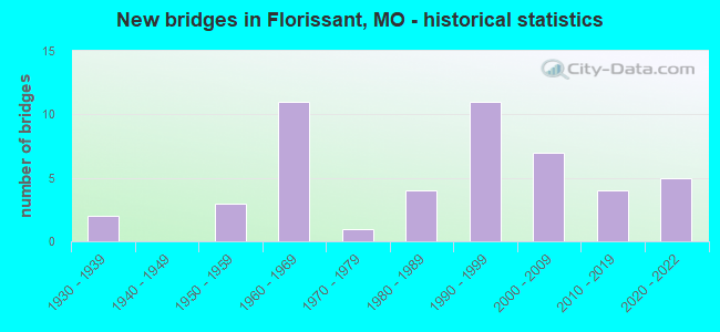
- New bridges - historical statistics
- 21930-1939
- 31950-1959
- 111960-1969
- 11970-1979
- 41980-1989
- 111990-1999
- 72000-2009
- 42010-2019
- 52020-2022
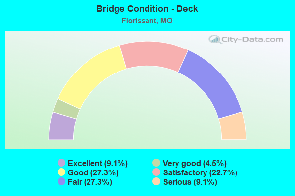
- Bridge Condition - Deck
- 9.1%Excellent
- 4.5%Very good
- 27.3%Good
- 22.7%Satisfactory
- 27.3%Fair
- 9.1%Serious
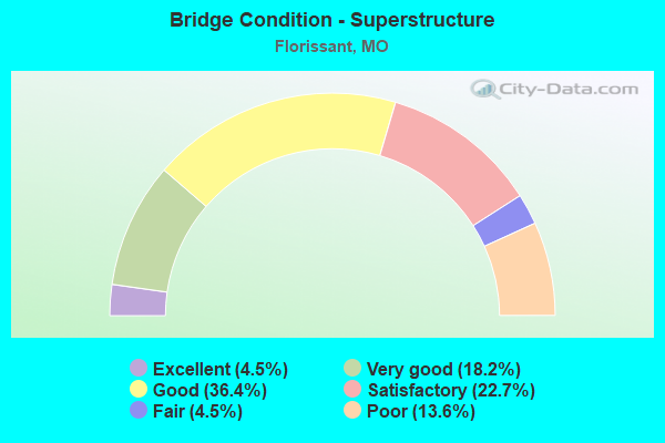
- Bridge Condition - Superstructure
- 4.5%Excellent
- 18.2%Very good
- 36.4%Good
- 22.7%Satisfactory
- 4.5%Fair
- 13.6%Poor
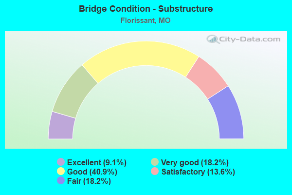
- Bridge Condition - Substructure
- 9.1%Excellent
- 18.2%Very good
- 40.9%Good
- 13.6%Satisfactory
- 18.2%Fair
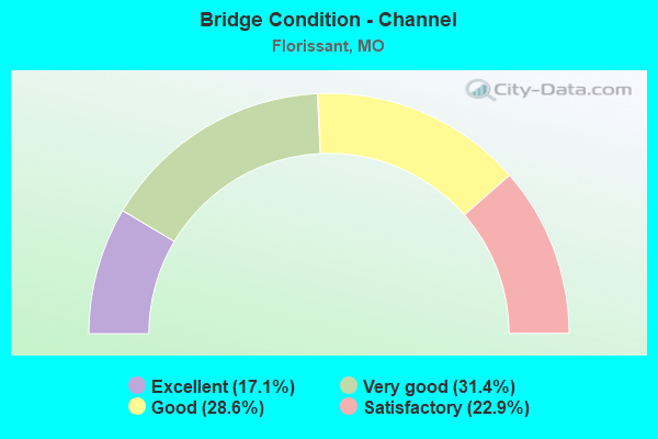
- Bridge Condition - Channel
- 17.1%Excellent
- 31.4%Very good
- 28.6%Good
- 22.9%Satisfactory
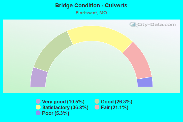
- Bridge Condition - Culverts
- 10.5%Very good
- 26.3%Good
- 36.8%Satisfactory
- 21.1%Fair
- 5.3%Poor
Find on map >> Show street view
Structure Number: 36424, Location: S 31 T 47 N R 7 E (Lat: 38.771239, Lng: -90.279939), Route carried "under" structure: Interstate 270, Year Built: 2020, Structure Length: 0. m, Average Daily Traffic: 67,382 (year 2021), Truck Traffic: 18%, Features Intersected: IS 270, Facility Carried by Structure: WEST FLORISSANT AV
Minimum Vertical Clearance: 5.03m (16.50ft), Kilometerpoint: 48.076, Lanes on structure: 9, Lanes under structure: 5, Material/Design: Prestressed concrete, Design/Construction: Tee Beam, Length of Maximum Span: 30.7m (100.7ft)
Find on map >> Show street view
Structure Number: 3693, Location: S 939 T 47 N R 6 E (Lat: 38.782089, Lng: -90.357367), Route carried "under" structure: City street , Year Built: 1989, Structure Length: 0. m, Average Daily Traffic: 2,924 (year 2021), Truck Traffic: 5%, Features Intersected: CST LYNN HAVEN LN, Facility Carried by Structure: US 67 S
Minimum Vertical Clearance: 5.18m (16.99ft), Kilometerpoint: 1.794, Lanes on structure: 4, Lanes under structure: 6, Material/Design: Prestressed concrete continuous, Design/Construction: Tee Beam, Length of Maximum Span: 14.6m (47.9ft)
Find on map >> Show street view
Structure Number: 648, Location: S 34 T 47 N R 6 E (Lat: 38.773614, Lng: -90.317078), Route carried "under" structure: State highway N, Year Built: 1960, Structure Length: 0. m, Average Daily Traffic: 18,128 (year 2021), Truck Traffic: 5%, Features Intersected: RT N, Facility Carried by Structure: IS 270 E
Minimum Vertical Clearance: 4.67m (15.32ft), Kilometerpoint: 0.058, Lanes on structure: 3, Lanes under structure: 5, Material/Design: Steel continuous, Design/Construction: Stringer/Multi-beam, Length of Maximum Span: 24.7m (81.0ft)
Find on map >> Show street view
Structure Number: 6481, Location: S 34 T 47 N R 6 E (Lat: 38.773767, Lng: -90.317197), Route carried "under" structure: State highway N, Year Built: 1960, Structure Length: 0. m, Average Daily Traffic: 18,128 (year 2021), Truck Traffic: 5%, Features Intersected: RT N, Facility Carried by Structure: IS 270 W
Minimum Vertical Clearance: 4.67m (15.32ft), Kilometerpoint: 0.039, Lanes on structure: 3, Lanes under structure: 5, Material/Design: Steel continuous, Design/Construction: Stringer/Multi-beam, Length of Maximum Span: 24.7m (81.0ft)