Bridge Statistics for Forest Hills, Michigan (MI)
Condition, Traffic, Stress, Structural Evaluation, Project Costs
- National Bridge Inventory (NBI) Statistics
- 67Number of bridges
- 1,086ft / 331mTotal length
- $137,000Total costs
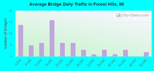
- 1,027,674Total average daily traffic
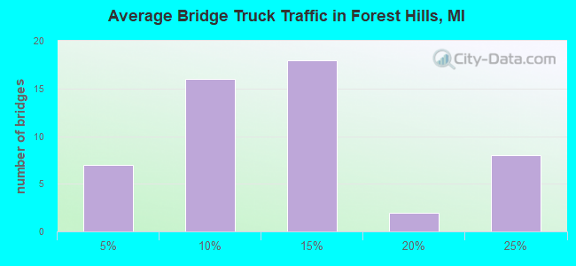
- 115,069Total average daily truck traffic
- National Bridge Inventory (NBI) Registered Bridges for Forest Hills
- No street view available for this location
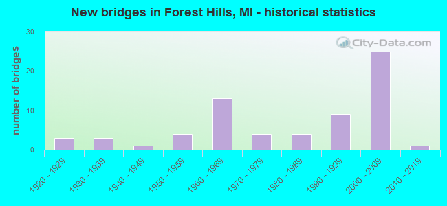
- New bridges - historical statistics
- 31920-1929
- 31930-1939
- 11940-1949
- 41950-1959
- 131960-1969
- 41970-1979
- 41980-1989
- 91990-1999
- 252000-2009
- 12010-2019
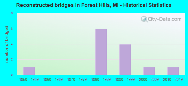
- Reconstructed bridges - Historical Statistics
- 11950-1959
- 01960-1969
- 01970-1979
- 61980-1989
- 41990-1999
- 12000-2009
- 12010-2019
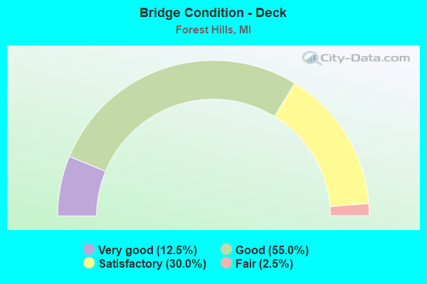
- Bridge Condition - Deck
- 12.5%Very good
- 55.0%Good
- 30.0%Satisfactory
- 2.5%Fair
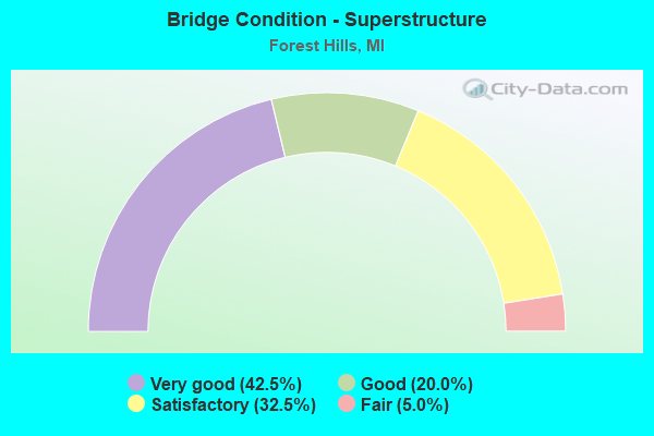
- Bridge Condition - Superstructure
- 42.5%Very good
- 20.0%Good
- 32.5%Satisfactory
- 5.0%Fair
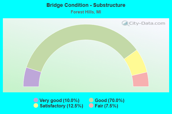
- Bridge Condition - Substructure
- 10.0%Very good
- 70.0%Good
- 12.5%Satisfactory
- 7.5%Fair
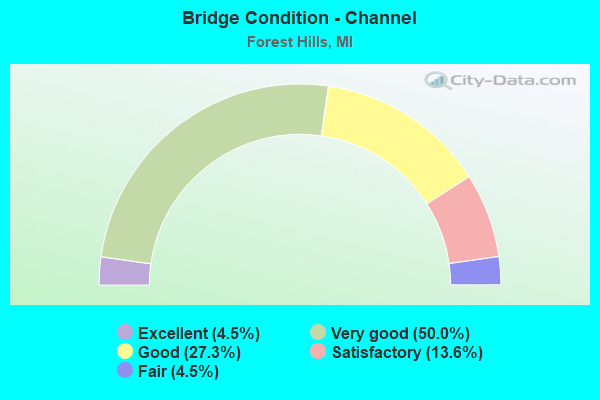
- Bridge Condition - Channel
- 4.5%Excellent
- 50.0%Very good
- 27.3%Good
- 13.6%Satisfactory
- 4.5%Fair
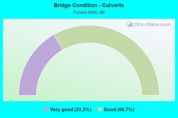
- Bridge Condition - Culverts
- 33.3%Very good
- 66.7%Good
Find on map >> Show street view
Structure Number: 4709, Location: 3.2 MI E OF M-11 (Lat: 42.888119, Lng: -85.486253), Route carried "on" structure: Interstate 96, Year Built: 1961, Year Reconstructed: 2001, Status: Open, Structure Length: 13.41m (44.00ft), Average Daily Traffic: 16,253 (year 2007), Truck Traffic: 23%, Average Future Daily Traffic: 13,729 (year 2018), Design Load: HS 25 or greater, Features Intersected: THORNAPPLE RIVER
Minimum Vertical Clearance: 30.48m (100.00ft), Kilometerpoint: 34.055, Lanes on structure: 2, Base Highway Network: Yes (Inventory Route: 40, Subroute: 6), Owner: State Highway Agency, Approaching Roadway Width: 11.7m (38.4ft), Skew: 12 degrees, Material/Design: Steel, Design/Construction: Stringer/Multi-beam, Number Of Spans In Main Unit: 4, Length of Maximum Span: 33.5m (109.9ft), Curb-To-Curb Width: 13.2m (43.3ft), Out-to-Out Width: 14.3m (46.9ft)
Condition: Deck: Good, Superstructure: Satisfactory, Substructure: Satisfactory, Channel: Very good, Operating Rating: 91.0 metric tons, Method Used To Determine Operating Rating: Load Factor (LF) rating reported by rating factor (RF) method using MS18 loading, Inventory Rating: 54.4 metric tons, Method Used To Determine Inventory Rating: Load Factor (LF) rating reported by rating factor (RF) method using MS18 loading, Structural Evaluation: Equal to present minimum criteria, Deck Geometry: Superior to present desirable criteria, Waterway Adequacy: Equal to present desirable criteria, Approach Roadway Alignment: Equal to present desirable criteria, Designated Inspection Frequency: Every 24 months, Underwater Inspection Frequency: Every 60 months, Inspection Date: March 2021, Underwater Inspection Date: May 2020, Deck Structure Type: Concrete Cast-file-Place, Wearing Surface/Protective System: Wearing Surface: Monolithic Concrete, Deck Protection: Epoxy Coated Reinforcing
Find on map >> Show street view
Structure Number: 471, Location: 3.2 MI E OF M-11 (Lat: 42.888397, Lng: -85.486344), Route carried "on" structure: Interstate 96, Year Built: 1961, Year Reconstructed: 2001, Status: Open, Structure Length: 13.41m (44.00ft), Average Daily Traffic: 16,253 (year 2007), Truck Traffic: 23%, Average Future Daily Traffic: 13,729 (year 2018), Design Load: HS 20+Mod, Features Intersected: THORNAPPLE RIVER
Minimum Vertical Clearance: 30.48m (100.00ft), Kilometerpoint: 33.826, Lanes on structure: 2, Base Highway Network: Yes (Inventory Route: 40, Subroute: 4), Owner: State Highway Agency, Approaching Roadway Width: 11.7m (38.4ft), Skew: 12 degrees, Material/Design: Steel, Design/Construction: Stringer/Multi-beam, Number Of Spans In Main Unit: 4, Length of Maximum Span: 33.5m (109.9ft), Curb-To-Curb Width: 13.2m (43.3ft), Out-to-Out Width: 14.2m (46.6ft)
Condition: Deck: Good, Superstructure: Satisfactory, Substructure: Good, Channel: Very good, Operating Rating: 91.0 metric tons, Method Used To Determine Operating Rating: Load Factor (LF) rating reported by rating factor (RF) method using MS18 loading, Inventory Rating: 54.4 metric tons, Method Used To Determine Inventory Rating: Load Factor (LF) rating reported by rating factor (RF) method using MS18 loading, Structural Evaluation: Equal to present minimum criteria, Deck Geometry: Superior to present desirable criteria, Waterway Adequacy: Equal to present desirable criteria, Approach Roadway Alignment: Equal to present desirable criteria, Designated Inspection Frequency: Every 24 months, Underwater Inspection Frequency: Every 60 months, Inspection Date: March 2021, Underwater Inspection Date: May 2020, Deck Structure Type: Concrete Cast-file-Place, Wearing Surface/Protective System: Wearing Surface: Monolithic Concrete, Deck Protection: Epoxy Coated Reinforcing
Find on map >> Show street view
Structure Number: 4715, Location: @ M-11 (Lat: 42.912817, Lng: -85.536350), Route carried "on" structure: Interstate 96, Year Built: 1961, Year Reconstructed: 1980, Status: Open, Structure Length: 8.07m (26.48ft), Average Daily Traffic: 24,982 (year 2010), Truck Traffic: 11%, Average Future Daily Traffic: 13,729 (year 2018), Design Load: HS 20, Features Intersected: M-11
Minimum Vertical Clearance: 30.48m (100.00ft), Kilometerpoint: 29.043, Lanes on structure: 2, Lanes under structure: 6, Base Highway Network: Yes (Inventory Route: 40, Subroute: 6), Owner: State Highway Agency, Approaching Roadway Width: 12.8m (42.0ft), Skew: 14 degrees, Material/Design: Steel, Design/Construction: Stringer/Multi-beam, Number Of Spans In Main Unit: 4, Length of Maximum Span: 23.1m (75.8ft), Curb-To-Curb Width: 9.7m (31.8ft), Out-to-Out Width: 10.9m (35.8ft)
Condition: Deck: Satisfactory, Superstructure: Satisfactory, Substructure: Good, Operating Rating: 82.5 metric tons, Method Used To Determine Operating Rating: Load Factor (LF), Inventory Rating: 49.5 metric tons, Method Used To Determine Inventory Rating: Load Factor (LF), Structural Evaluation: Equal to present minimum criteria, Deck Geometry: Meets minimum limits, Underclear: Equal to present minimum criteria, Approach Roadway Alignment: Equal to present desirable criteria, Designated Inspection Frequency: Every 24 months, Inspection Date: March 2021, Deck Structure Type: Concrete Cast-file-Place, Wearing Surface/Protective System: Wearing Surface: Latex Concrete
Find on map >> Show street view
Structure Number: 4716, Location: @ M-11 (Lat: 42.912833, Lng: -85.535900), Route carried "on" structure: Interstate 96, Year Built: 1961, Year Reconstructed: 1980, Status: Open, Structure Length: 8.07m (26.48ft), Average Daily Traffic: 24,982 (year 2007), Truck Traffic: 23%, Average Future Daily Traffic: 13,729 (year 2018), Design Load: HS 20, Features Intersected: M-11
Minimum Vertical Clearance: 30.48m (100.00ft), Kilometerpoint: 28.871, Lanes on structure: 2, Lanes under structure: 6, Base Highway Network: Yes (Inventory Route: 40, Subroute: 4), Owner: State Highway Agency, Approaching Roadway Width: 12.8m (42.0ft), Skew: 14 degrees, Material/Design: Steel, Design/Construction: Stringer/Multi-beam, Number Of Spans In Main Unit: 4, Length of Maximum Span: 23.1m (75.8ft), Curb-To-Curb Width: 9.7m (31.8ft), Out-to-Out Width: 10.9m (35.8ft)
Condition: Deck: Good, Superstructure: Satisfactory, Substructure: Good, Operating Rating: 82.5 metric tons, Method Used To Determine Operating Rating: Load Factor (LF), Inventory Rating: 49.5 metric tons, Method Used To Determine Inventory Rating: Load Factor (LF), Structural Evaluation: Equal to present minimum criteria, Deck Geometry: Meets minimum limits, Underclear: Equal to present minimum criteria, Approach Roadway Alignment: Equal to present desirable criteria, Designated Inspection Frequency: Every 24 months, Inspection Date: March 2021, Deck Structure Type: Concrete Cast-file-Place, Wearing Surface/Protective System: Wearing Surface: Latex Concrete
Find on map >> Show street view
Structure Number: 4717, Location: 0.6 MI E OF M-11 (Lat: 42.908069, Lng: -85.529422), Route carried "on" structure: County highway , Year Built: 1996, Status: Open, Structure Length: 6.52m (21.39ft), Average Daily Traffic: 16,209 (year 1997), Truck Traffic: 15%, Average Future Daily Traffic: 29,275 (year 2017), Design Load: HS 20, Features Intersected: I-96, Facility Carried by Structure: KRAFT AVE
Minimum Vertical Clearance: 30.48m (100.00ft), Kilometerpoint: 1.502, Lanes on structure: 4, Lanes under structure: 4, Owner: State Highway Agency, Approaching Roadway Width: 18.2m (59.7ft), Skew: 4 degrees, Material/Design: Prestressed concrete, Design/Construction: Stringer/Multi-beam, Number Of Spans In Main Unit: 4, Length of Maximum Span: 21.6m (70.9ft), Curb-To-Curb Width: 17.6m (57.7ft), Out-to-Out Width: 18.6m (61.0ft)
Condition: Deck: Satisfactory, Superstructure: Satisfactory, Substructure: Fair, Operating Rating: 54.1 metric tons, Method Used To Determine Operating Rating: Load Factor (LF), Inventory Rating: 32.4 metric tons, Method Used To Determine Inventory Rating: Load Factor (LF), Structural Evaluation: Somewhat better than minimum adequacy, Deck Geometry: Somewhat better than minimum adequacy, Underclear: Equal to present minimum criteria, Approach Roadway Alignment: Better than present minimum criteria, Designated Inspection Frequency: Every 24 months, Inspection Date: March 2021, Deck Structure Type: Concrete Cast-file-Place, Wearing Surface/Protective System: Wearing Surface: Epoxy Overlay, Deck Protection: Epoxy Coated Reinforcing
Find on map >> Show street view
Structure Number: 4718, Location: 2.0 MI E OF M-11 (Lat: 42.894286, Lng: -85.509258), Route carried "on" structure: County highway 2001, Year Built: 1961, Year Reconstructed: 1980, Status: Open, Structure Length: 9.11m (29.89ft), Average Daily Traffic: 9,379 (year 1996), Truck Traffic: 6%, Average Future Daily Traffic: 16,939 (year 2016), Design Load: H 20, Features Intersected: I-96, Facility Carried by Structure: THORNAPPLE RIV DRV
Minimum Vertical Clearance: 30.48m (100.00ft), Kilometerpoint: 4.609, Lanes on structure: 2, Lanes under structure: 4, Owner: State Highway Agency, Approaching Roadway Width: 10.3m (33.8ft), Skew: 4 degrees, Material/Design: Steel, Design/Construction: Stringer/Multi-beam, Number Of Spans In Main Unit: 4, Length of Maximum Span: 30.1m (98.8ft), Curb-To-Curb Width: 8.8m (28.9ft), Out-to-Out Width: 10.0m (32.8ft)
Condition: Deck: Satisfactory, Superstructure: Satisfactory, Substructure: Satisfactory, Operating Rating: 52.5 metric tons, Method Used To Determine Operating Rating: Load Factor (LF) rating reported by rating factor (RF) method using MS18 loading, Inventory Rating: 31.4 metric tons, Method Used To Determine Inventory Rating: Load Factor (LF) rating reported by rating factor (RF) method using MS18 loading, Structural Evaluation: Equal to present minimum criteria, Deck Geometry: Meets minimum limits, Underclear: Meets minimum limits, Approach Roadway Alignment: Equal to present desirable criteria, Designated Inspection Frequency: Every 24 months, Inspection Date: March 2021, Deck Structure Type: Concrete Cast-file-Place, Wearing Surface/Protective System: Wearing Surface: Latex Concrete
Find on map >> Show street view
Structure Number: 4719, Location: 4.7 MI E OF M-11 (Lat: 42.878083, Lng: -85.463519), Route carried "on" structure: County highway 4167, Year Built: 1959, Year Reconstructed: 2011, Status: Open, Structure Length: 8.41m (27.59ft), Average Daily Traffic: 5,700 (year 2010), Truck Traffic: 6%, Average Future Daily Traffic: 6,555 (year 2030), Design Load: H 20, Features Intersected: I-96, Facility Carried by Structure: WHITNEYVILLE AVE
Minimum Vertical Clearance: 30.48m (100.00ft), Kilometerpoint: 12.415, Lanes on structure: 2, Lanes under structure: 4, Owner: State Highway Agency, Approaching Roadway Width: 10.3m (33.8ft), Skew: 4 degrees, Material/Design: Steel, Design/Construction: Stringer/Multi-beam, Number Of Spans In Main Unit: 4, Length of Maximum Span: 28.3m (92.8ft), Curb-To-Curb Width: 8.9m (29.2ft), Out-to-Out Width: 10.1m (33.1ft)
Condition: Deck: Satisfactory, Superstructure: Fair, Substructure: Good, Operating Rating: 57.0 metric tons, Method Used To Determine Operating Rating: Load Factor (LF) rating reported by rating factor (RF) method using MS18 loading, Inventory Rating: 34.0 metric tons, Method Used To Determine Inventory Rating: Load Factor (LF) rating reported by rating factor (RF) method using MS18 loading, Structural Evaluation: Somewhat better than minimum adequacy, Deck Geometry: Meets minimum limits, Underclear: High priority of corrective action, Approach Roadway Alignment: Equal to present minimum criteria, Designated Inspection Frequency: Every 24 months, Inspection Date: March 2021, Deck Structure Type: Concrete Cast-file-Place, Wearing Surface/Protective System: Wearing Surface: Latex Concrete
Find on map >> Show street view
Structure Number: 472, Location: 1.9 MI W OF M-50 & M-91 (Lat: 42.878369, Lng: -85.410289), Route carried "on" structure: County highway , Year Built: 1959, Year Reconstructed: 1980, Status: Open, Structure Length: 6.92m (22.70ft), Average Daily Traffic: 615 (year 1996), Truck Traffic: 6%, Average Future Daily Traffic: 1,111 (year 2016), Design Load: H 20, Features Intersected: I-96, Facility Carried by Structure: MORSE LAKE AVE
Minimum Vertical Clearance: 30.48m (100.00ft), Kilometerpoint: 12.132, Lanes on structure: 2, Lanes under structure: 4, Owner: State Highway Agency, Approaching Roadway Width: 10.3m (33.8ft), Material/Design: Concrete continuous, Design/Construction: Tee Beam, Number Of Spans In Main Unit: 4, Length of Maximum Span: 21.6m (70.9ft), Curb-To-Curb Width: 8.9m (29.2ft), Out-to-Out Width: 10.2m (33.5ft)
Condition: Deck: Good, Superstructure: Satisfactory, Substructure: Good, Operating Rating: 56.7 metric tons, Method Used To Determine Operating Rating: Load Factor (LF) rating reported by rating factor (RF) method using MS18 loading, Inventory Rating: 34.0 metric tons, Method Used To Determine Inventory Rating: Load Factor (LF) rating reported by rating factor (RF) method using MS18 loading, Structural Evaluation: Equal to present minimum criteria, Deck Geometry: Somewhat better than minimum adequacy, Underclear: Meets minimum limits, Approach Roadway Alignment: Equal to present desirable criteria, Designated Inspection Frequency: Every 24 months, Inspection Date: November 2020, Deck Structure Type: Concrete Cast-file-Place, Wearing Surface/Protective System: Wearing Surface: Latex Concrete
Find on map >> Show street view
Structure Number: 4745, Location: 0.6 MI W OF M-11 (Lat: 42.919867, Lng: -85.546167), Route carried "on" structure: County highway , Year Built: 1961, Year Reconstructed: 1980, Status: Open, Structure Length: 8.87m (29.10ft), Average Daily Traffic: 13,391 (year 1996), Truck Traffic: 10%, Average Future Daily Traffic: 24,186 (year 2016), Design Load: H 20, Features Intersected: I-96, Facility Carried by Structure: BURTON STREET
Minimum Vertical Clearance: 30.48m (100.00ft), Kilometerpoint: 5.396, Lanes on structure: 2, Lanes under structure: 4, Owner: State Highway Agency, Approaching Roadway Width: 10.3m (33.8ft), Skew: 4 degrees, Material/Design: Steel, Design/Construction: Stringer/Multi-beam, Number Of Spans In Main Unit: 4, Length of Maximum Span: 30.4m (99.7ft), Curb or Sidewalk Widths: Left: 0.7m (2.3ft), Right: 0.7m (2.3ft), Curb-To-Curb Width: 7.9m (25.9ft), Out-to-Out Width: 10.0m (32.8ft)
Condition: Deck: Fair, Superstructure: Fair, Substructure: Fair, Operating Rating: 56.1 metric tons, Method Used To Determine Operating Rating: Load Factor (LF) rating reported by rating factor (RF) method using MS18 loading, Inventory Rating: 33.7 metric tons, Method Used To Determine Inventory Rating: Load Factor (LF) rating reported by rating factor (RF) method using MS18 loading, Structural Evaluation: Somewhat better than minimum adequacy, Deck Geometry: High priority of corrective action, Underclear: Meets minimum limits, Approach Roadway Alignment: Better than present minimum criteria, Designated Inspection Frequency: Every 24 months, Inspection Date: March 2021, Deck Structure Type: Concrete Cast-file-Place, Wearing Surface/Protective System: Wearing Surface: Monolithic Concrete
Find on map >> Show street view
Structure Number: 4854, Location: 6.4 MI E OF I-96 (Lat: 42.955308, Lng: -85.474542), Route carried "on" structure: State highway 21, Year Built: 2010, Status: Open, Structure Length: 14.63m (48.00ft), Average Daily Traffic: 23,900 (year 2009), Truck Traffic: 4%, Average Future Daily Traffic: 30,600 (year 2029), Design Load: Greater than HL93, Features Intersected: GRAND RIVER
Minimum Vertical Clearance: 30.48m (100.00ft), Kilometerpoint: 18.787, Lanes on structure: 4, Base Highway Network: Yes (Inventory Route: 40, Subroute: 5), Owner: State Highway Agency, Approaching Roadway Width: 19.9m (65.3ft), Skew: 23 degrees, Material/Design: Prestressed concrete, Design/Construction: Stringer/Multi-beam, Number Of Spans In Main Unit: 6, Length of Maximum Span: 25.2m (82.7ft), Curb or Sidewalk Widths: Left: 4.3m (14.1ft), Right: 0.0m, Curb-To-Curb Width: 19.9m (65.3ft), Out-to-Out Width: 25.4m (83.3ft)
Condition: Deck: Good, Superstructure: Very good, Substructure: Good, Channel: Very good, Operating Rating: 61.9 metric tons, Method Used To Determine Operating Rating: Load Factor (LF) rating reported by rating factor (RF) method using MS18 loading, Inventory Rating: 35.3 metric tons, Method Used To Determine Inventory Rating: Load Factor (LF) rating reported by rating factor (RF) method using MS18 loading, Structural Evaluation: Better than present minimum criteria, Deck Geometry: Better than present minimum criteria, Waterway Adequacy: Equal to present desirable criteria, Approach Roadway Alignment: Equal to present minimum criteria, Designated Inspection Frequency: Every 24 months, Underwater Inspection Frequency: Every 60 months, Inspection Date: October 2020, Underwater Inspection Date: May 2020, Deck Structure Type: Concrete Cast-file-Place, Wearing Surface/Protective System: Wearing Surface: Monolithic Concrete
Find on map >> Show street view
Structure Number: 4858, Location: 3.5 MI W OF ADA (Lat: 42.962822, Lng: -85.557058), Route carried "on" structure: State highway 21, Year Built: 1977, Year Reconstructed: 2015, Status: Open, Structure Length: 6.85m (22.47ft), Average Daily Traffic: 29,250 (year 2015), Truck Traffic: 4%, Average Future Daily Traffic: 34,000 (year 2035), Design Load: Greater than HL93, Features Intersected: GRAND RAPIDS EASTERN RR
Minimum Vertical Clearance: 30.48m (100.00ft), Kilometerpoint: 12.059, Lanes on structure: 5, Base Highway Network: Yes (Inventory Route: 40, Subroute: 5), Owner: State Highway Agency, Approaching Roadway Width: 21.9m (71.9ft), Skew: 5 degrees, Material/Design: Prestressed concrete, Design/Construction: Stringer/Multi-beam, Number Of Spans In Main Unit: 3, Length of Maximum Span: 22.9m (75.1ft), Curb or Sidewalk Widths: Left: 4.3m (14.1ft), Right: 0.0m, Curb-To-Curb Width: 22.3m (73.2ft), Out-to-Out Width: 27.6m (90.6ft)
Condition: Deck: Very good, Superstructure: Very good, Substructure: Good, Operating Rating: 50.2 metric tons, Method Used To Determine Operating Rating: Load and Resistance Factor Rating (LRFR) rating reported by rating factor(RF) method using HL-93 loadings, Inventory Rating: 38.6 metric tons, Method Used To Determine Inventory Rating: Load and Resistance Factor Rating (LRFR) rating reported by rating factor(RF) method using HL-93 loadings, Structural Evaluation: Better than present minimum criteria, Deck Geometry: Equal to present minimum criteria, Underclear: Somewhat better than minimum adequacy, Approach Roadway Alignment: Equal to present desirable criteria, Designated Inspection Frequency: Every 24 months, Inspection Date: November 2021, Deck Structure Type: Concrete Cast-file-Place, Wearing Surface/Protective System: Wearing Surface: Monolithic Concrete, Deck Protection: Epoxy Coated Reinforcing
Find on map >> Show street view
Structure Number: 5015, Location: 0.10 MI E OF THORNAPPLE R (Lat: 42.839981, Lng: -85.477086), Route carried "on" structure: County highway 4116, Year Built: 1967, Status: Open, Structure Length: 7.13m (23.39ft), Average Daily Traffic: 6,293 (year 2018), Truck Traffic: 8%, Average Future Daily Traffic: 8,500 (year 2038), Design Load: HS 20+Mod, Features Intersected: THORNAPPLE RIVER, Facility Carried by Structure: 68TH STREET
Minimum Vertical Clearance: 30.48m (100.00ft), Kilometerpoint: 18.465, Lanes on structure: 2, Owner: County Highway Agency, Approaching Roadway Width: 7.8m (25.6ft), Material/Design: Prestressed concrete, Design/Construction: Stringer/Multi-beam, Number Of Spans In Main Unit: 3, Length of Maximum Span: 23.8m (78.1ft), Curb or Sidewalk Widths: Left: 0.8m (2.6ft), Right: 0.8m (2.6ft), Curb-To-Curb Width: 9.1m (29.9ft), Out-to-Out Width: 11.4m (37.4ft)
Condition: Deck: Good, Superstructure: Good, Substructure: Good, Channel: Good, Inventory Rating: 58.8 metric tons, Method Used To Determine Inventory Rating: Load Factor (LF), Structural Evaluation: Better than present minimum criteria, Deck Geometry: Meets minimum limits, Waterway Adequacy: Equal to present desirable criteria, Approach Roadway Alignment: Equal to present desirable criteria, Length Of Structure Improvement: 7.00m (22.97ft), Designated Inspection Frequency: Every 24 months, Inspection Date: November 2021, Bridge Improvement Cost: $137,000, Total Project Cost: $137,000, Deck Structure Type: Concrete Cast-file-Place, Wearing Surface/Protective System: Wearing Surface: Latex Concrete
Find on map >> Show street view
Structure Number: 5016, Location: 0.80 MI E OF BURGER DRIVE (Lat: 42.877431, Lng: -85.476578), Route carried "on" structure: County highway , Year Built: 2003, Status: Open, Structure Length: 7.85m (25.75ft), Average Daily Traffic: 1,513 (year 2004), Truck Traffic: 10%, Average Future Daily Traffic: 2,570 (year 2024), Design Load: HS 25 or greater, Features Intersected: THORNAPPLE RIVER, Facility Carried by Structure: 48TH STREET
Minimum Vertical Clearance: 30.48m (100.00ft), Kilometerpoint: 1.811, Lanes on structure: 2, Owner: County Highway Agency, Approaching Roadway Width: 9.8m (32.2ft), Material/Design: Prestressed concrete, Design/Construction: Box Beam or Girders - Single/Spread, Number Of Spans In Main Unit: 3, Length of Maximum Span: 26.1m (85.6ft), Curb or Sidewalk Widths: Left: 2.0m (6.6ft), Right: 2.0m (6.6ft), Curb-To-Curb Width: 11.9m (39.0ft), Out-to-Out Width: 16.9m (55.4ft)
Condition: Deck: Very good, Superstructure: Very good, Substructure: Good, Channel: Excellent, Operating Rating: 99.0 metric tons, Method Used To Determine Operating Rating: Load Factor (LF), Inventory Rating: 72.7 metric tons, Method Used To Determine Inventory Rating: Load Factor (LF), Structural Evaluation: Better than present minimum criteria, Deck Geometry: Equal to present minimum criteria, Waterway Adequacy: Equal to present desirable criteria, Approach Roadway Alignment: Equal to present desirable criteria, Designated Inspection Frequency: Every 24 months, Inspection Date: November 2021, Deck Structure Type: Concrete Cast-file-Place, Wearing Surface/Protective System: Wearing Surface: Monolithic Concrete, Deck Protection: Epoxy Coated Reinforcing
Find on map >> Show street view
Structure Number: 5018, Location: 0.20 MI S OF 28TH STREEET (Lat: 42.911231, Lng: -85.496950), Route carried "on" structure: County highway 2001, Year Built: 1983, Status: Open, Structure Length: 6.70m (21.98ft), Average Daily Traffic: 22,250 (year 2005), Average Future Daily Traffic: 37,830 (year 2025), Design Load: HS 20+Mod, Features Intersected: THORNAPPLE RIVER, Facility Carried by Structure: CASCADE RD
Minimum Vertical Clearance: 30.48m (100.00ft), Kilometerpoint: 11.108, Lanes on structure: 5, Owner: County Highway Agency, Approaching Roadway Width: 18.0m (59.1ft), Material/Design: Prestressed concrete, Design/Construction: Box Beam or Girders - Multiple, Number Of Spans In Main Unit: 3, Length of Maximum Span: 23.1m (75.8ft), Curb or Sidewalk Widths: Left: 1.5m (4.9ft), Right: 1.5m (4.9ft), Curb-To-Curb Width: 18.0m (59.1ft), Out-to-Out Width: 22.2m (72.8ft)
Condition: Deck: Good, Superstructure: Good, Substructure: Good, Channel: Very good, Operating Rating: 92.1 metric tons, Method Used To Determine Operating Rating: Load Factor (LF), Inventory Rating: 55.2 metric tons, Method Used To Determine Inventory Rating: Load Factor (LF), Structural Evaluation: Better than present minimum criteria, Deck Geometry: High priority of replacement, Waterway Adequacy: Equal to present desirable criteria, Approach Roadway Alignment: Equal to present desirable criteria, Designated Inspection Frequency: Every 24 months, Inspection Date: November 2021, Deck Structure Type: Concrete Cast-file-Place, Wearing Surface/Protective System: Wearing Surface: Bituminous, Membrane: Preformed Fabric, Deck Protection: Epoxy Coated Reinforcing
Find on map >> Show street view
Structure Number: 5022, Location: 0.15 MI E OF GRND RIV DRV (Lat: 43.005750, Lng: -85.541914), Route carried "on" structure: County highway 4140, Year Built: 1966, Status: Open, Structure Length: 17.07m (56.00ft), Average Daily Traffic: 14,445 (year 2012), Truck Traffic: 8%, Average Future Daily Traffic: 20,223 (year 2022), Design Load: HS 20+Mod, Features Intersected: GRAND RIVER, Facility Carried by Structure: KNAPP STREET
Minimum Vertical Clearance: 30.48m (100.00ft), Kilometerpoint: 10.764, Lanes on structure: 2, Owner: County Highway Agency, Approaching Roadway Width: 12.2m (40.0ft), Skew: 2 degrees, Material/Design: Steel, Design/Construction: Stringer/Multi-beam, Number Of Spans In Main Unit: 5, Length of Maximum Span: 34.1m (111.9ft), Curb or Sidewalk Widths: Left: 0.8m (2.6ft), Right: 0.8m (2.6ft), Curb-To-Curb Width: 9.1m (29.9ft), Out-to-Out Width: 11.4m (37.4ft)
Condition: Deck: Satisfactory, Superstructure: Good, Substructure: Good, Channel: Very good, Operating Rating: 77.2 metric tons, Method Used To Determine Operating Rating: Load Factor (LF), Inventory Rating: 46.2 metric tons, Method Used To Determine Inventory Rating: Load Factor (LF), Structural Evaluation: Better than present minimum criteria, Deck Geometry: Meets minimum limits, Waterway Adequacy: Equal to present minimum criteria, Approach Roadway Alignment: Equal to present desirable criteria, Designated Inspection Frequency: Every 24 months, Inspection Date: September 2020, Deck Structure Type: Concrete Cast-file-Place, Wearing Surface/Protective System: Wearing Surface: Epoxy Overlay
Find on map >> Show street view
Structure Number: 5067, Location: 0.10 MILE N OF FULTON ST (Lat: 42.964122, Lng: -85.560933), Route carried "on" structure: County highway , Year Built: 1982, Status: Open, Structure Length: 4.08m (13.39ft), Average Daily Traffic: 10,539 (year 2005), Average Future Daily Traffic: 17,920 (year 2025), Design Load: HS 20+Mod, Features Intersected: GRAND TRUNK RAILROAD, Facility Carried by Structure: CRAHEN RD
Minimum Vertical Clearance: 30.48m (100.00ft), Kilometerpoint: 0.319, Lanes on structure: 2, Owner: County Highway Agency, Approaching Roadway Width: 12.2m (40.0ft), Skew: 2 degrees, Material/Design: Prestressed concrete, Design/Construction: Box Beam or Girders - Multiple, Number Of Spans In Main Unit: 3, Length of Maximum Span: 13.7m (44.9ft), Curb-To-Curb Width: 12.5m (41.0ft), Out-to-Out Width: 13.2m (43.3ft)
Condition: Deck: Satisfactory, Superstructure: Satisfactory, Substructure: Good, Operating Rating: 69.0 metric tons, Method Used To Determine Operating Rating: Load Factor (LF), Inventory Rating: 41.3 metric tons, Method Used To Determine Inventory Rating: Load Factor (LF), Structural Evaluation: Equal to present minimum criteria, Deck Geometry: Somewhat better than minimum adequacy, Approach Roadway Alignment: Equal to present desirable criteria, Designated Inspection Frequency: Every 24 months, Inspection Date: November 2021, Deck Structure Type: Concrete Cast-file-Place, Wearing Surface/Protective System: Wearing Surface: Bituminous, Membrane: Preformed Fabric, Deck Protection: Epoxy Coated Reinforcing
Find on map >> Show street view
Structure Number: 5068, Location: 200FT N OF KNAPP ST (Lat: 43.007383, Lng: -85.530950), Route carried "on" structure: County highway , Year Built: 1942, Year Reconstructed: 2001, Status: Open, Structure Length: 0.61m (2.00ft), Average Daily Traffic: 2,565 (year 1998), Truck Traffic: 5%, Average Future Daily Traffic: 4,600 (year 2018), Design Load: H 20, Features Intersected: EGYPT CREEK, Facility Carried by Structure: PETTIS AVENUE
Minimum Vertical Clearance: 30.48m (100.00ft), Kilometerpoint: 8.206, Lanes on structure: 2, Base Highway Network: Yes (Inventory Route: 44, Subroute: 8), Owner: County Highway Agency, Approaching Roadway Width: 8.5m (27.9ft), Skew: 1 degrees, Material/Design: Concrete, Design/Construction: Slab, Number Of Spans In Main Unit: 1, Length of Maximum Span: 6.1m (20.0ft), Curb-To-Curb Width: 9.4m (30.8ft), Out-to-Out Width: 10.2m (33.5ft)
Condition: Deck: Satisfactory, Superstructure: Satisfactory, Substructure: Good, Channel: Fair, Operating Rating: 44.1 metric tons, Method Used To Determine Operating Rating: Load Factor (LF), Inventory Rating: 26.4 metric tons, Method Used To Determine Inventory Rating: Load Factor (LF), Structural Evaluation: Equal to present minimum criteria, Deck Geometry: Meets minimum limits, Waterway Adequacy: Equal to present minimum criteria, Approach Roadway Alignment: Better than present minimum criteria, Designated Inspection Frequency: Every 24 months, Inspection Date: September 2020, Deck Structure Type: Concrete Cast-file-Place, Wearing Surface/Protective System: Wearing Surface: Bituminous
Find on map >> Show street view
Structure Number: 5069, Location: 0.40 MI NW OF HONEY CREEK (Lat: 42.961122, Lng: -85.482158), Route carried "on" structure: County highway 4157, Year Built: 1985, Status: Open, Structure Length: 0.88m (2.89ft), Average Daily Traffic: 3,164 (year 2005), Average Future Daily Traffic: 5,380 (year 2025), Design Load: HS 20+Mod, Features Intersected: HONEY CREEK, Facility Carried by Structure: PETTIS AVE
Minimum Vertical Clearance: 30.48m (100.00ft), Kilometerpoint: 1.115, Lanes on structure: 2, Owner: County Highway Agency, Approaching Roadway Width: 11.6m (38.1ft), Material/Design: Steel, Design/Construction: Culvert, Number Of Spans In Main Unit: 2, Length of Maximum Span: 3.9m (12.8ft)
Condition: Channel: Very good, Culverts: Very good, Operating Rating: 97.2 metric tons, Method Used To Determine Operating Rating: Load Factor (LF) rating reported by rating factor (RF) method using MS18 loading, Inventory Rating: 97.2 metric tons, Method Used To Determine Inventory Rating: Load Factor (LF) rating reported by rating factor (RF) method using MS18 loading, Structural Evaluation: Equal to present desirable criteria, Waterway Adequacy: Equal to present desirable criteria, Approach Roadway Alignment: Equal to present desirable criteria, Designated Inspection Frequency: Every 24 months, Inspection Date: September 2020
Find on map >> Show street view
Structure Number: 507, Location: 0.55 MI N OF LARAWAY LAKE (Lat: 42.939775, Lng: -85.491111), Route carried "on" structure: County highway 2001, Year Built: 2004, Status: Open, Structure Length: 5.14m (16.86ft), Average Daily Traffic: 12,600 (year 2005), Truck Traffic: 3%, Average Future Daily Traffic: 21,600 (year 2025), Design Load: HS 20+Mod, Features Intersected: THORNAPPLE RIVER, Facility Carried by Structure: THORNAPPLE RIVER D
Minimum Vertical Clearance: 30.48m (100.00ft), Kilometerpoint: 4.662, Lanes on structure: 2, Owner: County Highway Agency, Approaching Roadway Width: 11.0m (36.1ft), Skew: 1 degrees, Material/Design: Prestressed concrete, Design/Construction: Box Beam or Girders - Single/Spread, Number Of Spans In Main Unit: 2, Length of Maximum Span: 25.7m (84.3ft), Curb-To-Curb Width: 11.0m (36.1ft), Out-to-Out Width: 12.4m (40.7ft)
Condition: Deck: Good, Superstructure: Very good, Substructure: Satisfactory, Channel: Very good, Operating Rating: 89.3 metric tons, Method Used To Determine Operating Rating: Load Factor (LF), Inventory Rating: 41.5 metric tons, Method Used To Determine Inventory Rating: Load Factor (LF), Structural Evaluation: Equal to present minimum criteria, Deck Geometry: Meets minimum limits, Waterway Adequacy: Equal to present minimum criteria, Approach Roadway Alignment: Equal to present desirable criteria, Designated Inspection Frequency: Every 24 months, Underwater Inspection Frequency: Every 60 months, Inspection Date: November 2021, Underwater Inspection Date: October 2020, Deck Structure Type: Concrete Cast-file-Place, Wearing Surface/Protective System: Wearing Surface: Monolithic Concrete
Find on map >> Show street view
Structure Number: 5071, Location: 0.15 MI S OF ADA DRIVE (Lat: 42.953333, Lng: -85.485653), Route carried "on" structure: County highway 2001, Year Built: 1930, Year Reconstructed: 1989, Status: Open, Structure Length: 4.57m (14.99ft), Average Daily Traffic: 11,887 (year 2005), Average Future Daily Traffic: 20,210 (year 2025), Design Load: HS 20+Mod, Features Intersected: THORNAPPLE RIVER, Facility Carried by Structure: THORNAPPLE RIVER D
Minimum Vertical Clearance: 30.48m (100.00ft), Kilometerpoint: 6.684, Lanes on structure: 2, Owner: County Highway Agency, Approaching Roadway Width: 109.7m (359.9ft), Material/Design: Steel, Design/Construction: Stringer/Multi-beam, Number Of Spans In Main Unit: 2, Length of Maximum Span: 22.8m (74.8ft), Curb or Sidewalk Widths: Left: 0.9m (3.0ft), Right: 0.9m (3.0ft), Curb-To-Curb Width: 11.0m (36.1ft), Out-to-Out Width: 13.4m (44.0ft)
Condition: Deck: Good, Superstructure: Very good, Substructure: Good, Channel: Good, Operating Rating: 82.6 metric tons, Method Used To Determine Operating Rating: Load Factor (LF) rating reported by rating factor (RF) method using MS18 loading, Inventory Rating: 49.6 metric tons, Method Used To Determine Inventory Rating: Load Factor (LF) rating reported by rating factor (RF) method using MS18 loading, Structural Evaluation: Better than present minimum criteria, Deck Geometry: Meets minimum limits, Waterway Adequacy: Equal to present minimum criteria, Approach Roadway Alignment: Equal to present minimum criteria, Designated Inspection Frequency: Every 24 months, Inspection Date: September 2020, Deck Structure Type: Concrete Cast-file-Place, Wearing Surface/Protective System: Wearing Surface: Monolithic Concrete, Deck Protection: Epoxy Coated Reinforcing
Find on map >> Show street view
Structure Number: 5075, Location: 0.95 MI N OF 60TH ST (Lat: 42.869767, Lng: -85.458978), Route carried "on" structure: County highway 4167, Year Built: 1926, Year Reconstructed: 1962, Status: Open, Structure Length: 0.73m (2.40ft), Average Daily Traffic: 4,776 (year 2003), Average Future Daily Traffic: 8,120 (year 2023), Design Load: HS 20+Mod, Features Intersected: NO NAME CREEK, Facility Carried by Structure: WHITNEYVILLE AVE
Minimum Vertical Clearance: 30.48m (100.00ft), Kilometerpoint: 11.362, Lanes on structure: 2, Owner: County Highway Agency, Approaching Roadway Width: 9.1m (29.9ft), Material/Design: Concrete, Design/Construction: Tee Beam, Number Of Spans In Main Unit: 1, Length of Maximum Span: 6.4m (21.0ft), Curb-To-Curb Width: 10.1m (33.1ft), Out-to-Out Width: 10.6m (34.8ft)
Condition: Deck: Satisfactory, Superstructure: Satisfactory, Substructure: Good, Channel: Good, Operating Rating: 38.2 metric tons, Method Used To Determine Operating Rating: Load Factor (LF), Inventory Rating: 22.9 metric tons, Method Used To Determine Inventory Rating: Load Factor (LF), Structural Evaluation: Equal to present minimum criteria, Deck Geometry: Meets minimum limits, Waterway Adequacy: Equal to present desirable criteria, Approach Roadway Alignment: Equal to present desirable criteria, Designated Inspection Frequency: Every 24 months, Inspection Date: November 2021, Deck Structure Type: Concrete Cast-file-Place, Wearing Surface/Protective System: Wearing Surface: Bituminous
Find on map >> Show street view
Structure Number: 5129, Location: 300 FT N OF CANNONSBURG (Lat: 43.054714, Lng: -85.469847), Route carried "on" structure: County highway , Year Built: 1978, Status: Open, Structure Length: 1.52m (4.99ft), Average Daily Traffic: 134 (year 2005), Average Future Daily Traffic: 230 (year 2025), Design Load: HS 20+Mod, Features Intersected: BEAR CREEK, Facility Carried by Structure: JOYCE DRIVE
Minimum Vertical Clearance: 30.48m (100.00ft), Kilometerpoint: 0.084, Lanes on structure: 2, Owner: County Highway Agency, Approaching Roadway Width: 5.5m (18.0ft), Material/Design: Prestressed concrete, Design/Construction: Box Beam or Girders - Multiple, Number Of Spans In Main Unit: 1, Length of Maximum Span: 15.2m (49.9ft), Curb-To-Curb Width: 6.7m (22.0ft), Out-to-Out Width: 7.4m (24.3ft)
Condition: Deck: Very good, Superstructure: Very good, Substructure: Good, Channel: Very good, Operating Rating: 44.4 metric tons, Method Used To Determine Operating Rating: Load Factor (LF), Inventory Rating: 26.6 metric tons, Method Used To Determine Inventory Rating: Load Factor (LF), Structural Evaluation: Equal to present minimum criteria, Deck Geometry: Meets minimum limits, Waterway Adequacy: Equal to present desirable criteria, Approach Roadway Alignment: Equal to present desirable criteria, Designated Inspection Frequency: Every 24 months, Inspection Date: December 2021, Deck Structure Type: Concrete Precast Panels, Wearing Surface/Protective System: Wearing Surface: Bituminous
Find on map >> Show street view
Structure Number: 5131, Location: 0.20 MI SOUTH OF 6 MI RD (Lat: 43.054708, Lng: -85.450675), Route carried "on" structure: County highway , Year Built: 1970, Status: Open, Structure Length: 0.64m (2.10ft), Average Daily Traffic: 91 (year 2005), Average Future Daily Traffic: 150 (year 2025), Design Load: HS 20+Mod, Features Intersected: BEAR CREEK, Facility Carried by Structure: GILES AVE
Minimum Vertical Clearance: 30.48m (100.00ft), Kilometerpoint: 2.895, Lanes on structure: 2, Owner: County Highway Agency, Approaching Roadway Width: 7.3m (24.0ft), Material/Design: Steel, Design/Construction: Culvert, Number Of Spans In Main Unit: 2, Length of Maximum Span: 2.7m (8.9ft)
Condition: Channel: Satisfactory, Culverts: Good, Operating Rating: 71.9 metric tons, Method Used To Determine Operating Rating: Load Factor (LF) rating reported by rating factor (RF) method using MS18 loading, Inventory Rating: 68.7 metric tons, Method Used To Determine Inventory Rating: Load Factor (LF) rating reported by rating factor (RF) method using MS18 loading, Structural Evaluation: Better than present minimum criteria, Waterway Adequacy: Equal to present desirable criteria, Approach Roadway Alignment: Equal to present desirable criteria, Designated Inspection Frequency: Every 24 months, Inspection Date: December 2021
Find on map >> Show street view
Structure Number: 5132, Location: 160 FT E OF RAMSDELL DRV (Lat: 43.055544, Lng: -85.466050), Route carried "on" structure: County highway , Year Built: 1927, Status: Open, Structure Length: 0.70m (2.30ft), Average Daily Traffic: 150 (year 2006), Average Future Daily Traffic: 260 (year 2026), Design Load: HS 20+Mod, Features Intersected: BEAR CREEK, Facility Carried by Structure: TOWNSEND PARK DRV
Minimum Vertical Clearance: 30.48m (100.00ft), Kilometerpoint: 0.052, Lanes on structure: 2, Owner: Local Park, Forest, or Reservation Agency, Approaching Roadway Width: 5.5m (18.0ft), Material/Design: Concrete, Design/Construction: Slab, Number Of Spans In Main Unit: 1, Length of Maximum Span: 6.1m (20.0ft), Curb-To-Curb Width: 6.1m (20.0ft), Out-to-Out Width: 7.0m (23.0ft)
Condition: Deck: Very good, Superstructure: Very good, Substructure: Very good, Channel: Very good, Operating Rating: 31.7 metric tons, Method Used To Determine Operating Rating: Load Factor (LF), Inventory Rating: 19.0 metric tons, Method Used To Determine Inventory Rating: Load Factor (LF), Structural Evaluation: Somewhat better than minimum adequacy, Deck Geometry: Meets minimum limits, Waterway Adequacy: Equal to present desirable criteria, Approach Roadway Alignment: Equal to present desirable criteria, Designated Inspection Frequency: Every 24 months, Inspection Date: December 2021, Deck Structure Type: Concrete Cast-file-Place, Wearing Surface/Protective System: Wearing Surface: Bituminous
Find on map >> Show street view
Structure Number: 5133, Location: EASTERLY END OF DRIVE (Lat: 43.055756, Lng: -85.461750), Route carried "on" structure: County highway , Year Built: 1927, Status: Open, Structure Length: 0.70m (2.30ft), Average Daily Traffic: 150 (year 2006), Average Future Daily Traffic: 260 (year 2026), Design Load: HS 20+Mod, Features Intersected: BEAR CREEK, Facility Carried by Structure: TOWNSEND PARK DRV
Minimum Vertical Clearance: 30.48m (100.00ft), Kilometerpoint: 0.624, Lanes on structure: 2, Owner: Local Park, Forest, or Reservation Agency, Approaching Roadway Width: 5.5m (18.0ft), Skew: 1 degrees, Material/Design: Concrete, Design/Construction: Slab, Number Of Spans In Main Unit: 1, Length of Maximum Span: 6.1m (20.0ft), Curb-To-Curb Width: 6.1m (20.0ft), Out-to-Out Width: 7.0m (23.0ft)
Condition: Deck: Very good, Superstructure: Very good, Substructure: Very good, Channel: Satisfactory, Operating Rating: 31.6 metric tons, Method Used To Determine Operating Rating: Load Factor (LF), Inventory Rating: 19.0 metric tons, Method Used To Determine Inventory Rating: Load Factor (LF), Structural Evaluation: Somewhat better than minimum adequacy, Deck Geometry: Meets minimum limits, Waterway Adequacy: Equal to present desirable criteria, Approach Roadway Alignment: Equal to present minimum criteria, Designated Inspection Frequency: Every 24 months, Inspection Date: December 2021, Deck Structure Type: Concrete Cast-file-Place, Wearing Surface/Protective System: Wearing Surface: Bituminous
Find on map >> Show street view
Structure Number: 5135, Location: 0.35 MI N OF 60TH ST (Lat: 42.860711, Lng: -85.498175), Route carried "on" structure: County highway , Year Built: 1967, Year Reconstructed: 1999, Status: Open, Structure Length: 0.79m (2.59ft), Average Daily Traffic: 1,201 (year 2004), Average Future Daily Traffic: 2,040 (year 2024), Design Load: HS 20+Mod, Features Intersected: UNNAMED, Facility Carried by Structure: THORNAPPLE RIV DRV
Minimum Vertical Clearance: 30.48m (100.00ft), Kilometerpoint: 0.592, Lanes on structure: 2, Owner: County Highway Agency, Approaching Roadway Width: 7.3m (24.0ft), Material/Design: Steel, Design/Construction: Culvert, Number Of Spans In Main Unit: 2, Length of Maximum Span: 3.9m (12.8ft)
Condition: Channel: Good, Culverts: Good, Operating Rating: 97.2 metric tons, Method Used To Determine Operating Rating: Load Factor (LF) rating reported by rating factor (RF) method using MS18 loading, Inventory Rating: 97.2 metric tons, Method Used To Determine Inventory Rating: Load Factor (LF) rating reported by rating factor (RF) method using MS18 loading, Structural Evaluation: Better than present minimum criteria, Waterway Adequacy: Equal to present desirable criteria, Approach Roadway Alignment: Better than present minimum criteria, Designated Inspection Frequency: Every 24 months, Inspection Date: November 2021
Find on map >> Show street view
Structure Number: 5136, Location: 0.25 MI S OF 48TH ST (Lat: 42.873978, Lng: -85.467983), Route carried "on" structure: County highway , Year Built: 1971, Status: Open, Structure Length: 0.79m (2.59ft), Average Daily Traffic: 469 (year 2004), Average Future Daily Traffic: 800 (year 2024), Design Load: HS 20+Mod, Features Intersected: UNNAMED, Facility Carried by Structure: BUTTRICK AVE
Minimum Vertical Clearance: 30.48m (100.00ft), Kilometerpoint: 3.663, Lanes on structure: 2, Owner: County Highway Agency, Approaching Roadway Width: 4.9m (16.1ft), Material/Design: Steel, Design/Construction: Culvert, Number Of Spans In Main Unit: 2, Length of Maximum Span: 3.9m (12.8ft)
Condition: Channel: Satisfactory, Culverts: Good, Operating Rating: 52.2 metric tons, Method Used To Determine Operating Rating: Load Factor (LF) rating reported by rating factor (RF) method using MS18 loading, Inventory Rating: 46.0 metric tons, Method Used To Determine Inventory Rating: Load Factor (LF) rating reported by rating factor (RF) method using MS18 loading, Structural Evaluation: Better than present minimum criteria, Waterway Adequacy: Equal to present desirable criteria, Approach Roadway Alignment: Equal to present desirable criteria, Designated Inspection Frequency: Every 24 months, Inspection Date: November 2021
Find on map >> Show street view
Structure Number: 12737, Location: CASCADE TWP SEC 22 (Lat: 42.887833, Lng: -85.485978), Route carried "on" structure: Ramp State highway 6, Year Built: 1997, Status: Open, Structure Length: 33.09m (108.56ft), Average Daily Traffic: 13,761 (year 2007), Truck Traffic: 13%, Average Future Daily Traffic: 9,082 (year 2018), Design Load: HS 25 or greater, Features Intersected: THORNAPPLE RIVER
Minimum Vertical Clearance: 30.48m (100.00ft), Kilometerpoint: 26.940, Lanes on structure: 2, Owner: State Highway Agency, Approaching Roadway Width: 13.1m (43.0ft), Material/Design: Steel continuous, Design/Construction: Stringer/Multi-beam, Number Of Spans In Main Unit: 6, Length of Maximum Span: 55.4m (181.8ft), Curb-To-Curb Width: 13.1m (43.0ft), Out-to-Out Width: 14.2m (46.6ft)
Condition: Deck: Good, Superstructure: Good, Substructure: Good, Channel: Very good, Operating Rating: 75.8 metric tons, Method Used To Determine Operating Rating: Load Factor (LF), Inventory Rating: 45.4 metric tons, Method Used To Determine Inventory Rating: Load Factor (LF), Structural Evaluation: Better than present minimum criteria, Deck Geometry: Superior to present desirable criteria, Waterway Adequacy: Equal to present desirable criteria, Approach Roadway Alignment: Equal to present desirable criteria, Designated Inspection Frequency: Every 24 months, Underwater Inspection Frequency: Every 60 months, Inspection Date: November 2020, Underwater Inspection Date: May 2020, Deck Structure Type: Concrete Cast-file-Place, Wearing Surface/Protective System: Wearing Surface: Monolithic Concrete, Deck Protection: Epoxy Coated Reinforcing
Find on map >> Show street view
Structure Number: 12812, Location: CASCADE TWP SEC 28 (Lat: 42.882414, Lng: -85.491036), Route carried "on" structure: Ramp State highway 6, Year Built: 1999, Status: Open, Structure Length: 5.32m (17.45ft), Average Daily Traffic: 13,761 (year 2007), Truck Traffic: 8%, Average Future Daily Traffic: 14,900 (year 2015), Design Load: HS 25 or greater, Features Intersected: CSX RR
Minimum Vertical Clearance: 30.48m (100.00ft), Kilometerpoint: 26.249, Lanes on structure: 4, Owner: State Highway Agency, Approaching Roadway Width: 26.5m (86.9ft), Skew: 2 degrees, Material/Design: Prestressed concrete, Design/Construction: Stringer/Multi-beam, Number Of Spans In Main Unit: 3, Length of Maximum Span: 19.2m (63.0ft), Curb-To-Curb Width: 26.5m (86.9ft), Out-to-Out Width: 27.6m (90.6ft)
Condition: Deck: Good, Superstructure: Good, Substructure: Good, Operating Rating: 66.7 metric tons, Method Used To Determine Operating Rating: Load Factor (LF) rating reported by rating factor (RF) method using MS18 loading, Inventory Rating: 39.9 metric tons, Method Used To Determine Inventory Rating: Load Factor (LF) rating reported by rating factor (RF) method using MS18 loading, Structural Evaluation: Better than present minimum criteria, Deck Geometry: Superior to present desirable criteria, Underclear: Superior to present desirable criteria, Approach Roadway Alignment: Better than present minimum criteria, Designated Inspection Frequency: Every 24 months, Inspection Date: November 2020, Deck Structure Type: Concrete Cast-file-Place, Wearing Surface/Protective System: Wearing Surface: Monolithic Concrete, Deck Protection: Epoxy Coated Reinforcing
Find on map >> Show street view
Structure Number: 12813, Location: CASCADE TWP SEC 28 (Lat: 42.882519, Lng: -85.491650), Route carried "on" structure: State highway 6, Year Built: 1999, Status: Open, Structure Length: 5.32m (17.45ft), Average Daily Traffic: 13,761 (year 2007), Truck Traffic: 13%, Average Future Daily Traffic: 8,051 (year 2018), Design Load: HS 25 or greater, Features Intersected: CSX RR
Minimum Vertical Clearance: 30.48m (100.00ft), Kilometerpoint: 26.195, Lanes on structure: 3, Base Highway Network: Yes (Inventory Route: 200, Subroute: 2), Owner: State Highway Agency, Approaching Roadway Width: 18.0m (59.1ft), Skew: 2 degrees, Material/Design: Prestressed concrete, Design/Construction: Stringer/Multi-beam, Number Of Spans In Main Unit: 3, Length of Maximum Span: 19.2m (63.0ft), Curb-To-Curb Width: 18.0m (59.1ft), Out-to-Out Width: 19.0m (62.3ft)
Condition: Deck: Good, Superstructure: Very good, Substructure: Good, Operating Rating: 64.2 metric tons, Method Used To Determine Operating Rating: Load Factor (LF) rating reported by rating factor (RF) method using MS18 loading, Inventory Rating: 38.6 metric tons, Method Used To Determine Inventory Rating: Load Factor (LF) rating reported by rating factor (RF) method using MS18 loading, Structural Evaluation: Better than present minimum criteria, Deck Geometry: Better than present minimum criteria, Underclear: Superior to present desirable criteria, Approach Roadway Alignment: Better than present minimum criteria, Designated Inspection Frequency: Every 24 months, Inspection Date: November 2020, Deck Structure Type: Concrete Cast-file-Place, Wearing Surface/Protective System: Wearing Surface: Monolithic Concrete, Deck Protection: Epoxy Coated Reinforcing
Find on map >> Show street view
Structure Number: 12816, Location: CASCADE TWP SEC 33 (Lat: 42.865553, Lng: -85.498347), Route carried "on" structure: State highway 6, Year Built: 1999, Status: Open, Structure Length: 7.69m (25.23ft), Average Daily Traffic: 13,761 (year 2007), Truck Traffic: 8%, Average Future Daily Traffic: 14,900 (year 2015), Design Load: HS 25 or greater, Features Intersected: THORNAPPLE RIVER DRIVE
Minimum Vertical Clearance: 30.48m (100.00ft), Kilometerpoint: 24.196, Lanes on structure: 2, Lanes under structure: 2, Base Highway Network: Yes (Inventory Route: 200, Subroute: 1), Owner: State Highway Agency, Approaching Roadway Width: 13.2m (43.3ft), Skew: 5 degrees, Material/Design: Prestressed concrete, Design/Construction: Stringer/Multi-beam, Number Of Spans In Main Unit: 3, Length of Maximum Span: 40.6m (133.2ft), Curb-To-Curb Width: 13.2m (43.3ft), Out-to-Out Width: 14.2m (46.6ft)
Condition: Deck: Satisfactory, Superstructure: Good, Substructure: Good, Operating Rating: 85.5 metric tons, Method Used To Determine Operating Rating: Load Factor (LF) rating reported by rating factor (RF) method using MS18 loading, Inventory Rating: 47.6 metric tons, Method Used To Determine Inventory Rating: Load Factor (LF) rating reported by rating factor (RF) method using MS18 loading, Structural Evaluation: Better than present minimum criteria, Deck Geometry: Superior to present desirable criteria, Underclear: Equal to present minimum criteria, Approach Roadway Alignment: Equal to present desirable criteria, Designated Inspection Frequency: Every 24 months, Inspection Date: May 2021, Deck Structure Type: Concrete Cast-file-Place, Wearing Surface/Protective System: Wearing Surface: Monolithic Concrete, Deck Protection: Epoxy Coated Reinforcing
Find on map >> Show street view
Structure Number: 12817, Location: CASCADE TWP SEC 33 (Lat: 42.866211, Lng: -85.498364), Route carried "on" structure: State highway 6, Year Built: 1999, Status: Open, Structure Length: 7.69m (25.23ft), Average Daily Traffic: 13,761 (year 2007), Truck Traffic: 8%, Average Future Daily Traffic: 14,900 (year 2015), Design Load: HS 25 or greater, Features Intersected: THORNAPPLE RIVER DRIVE
Minimum Vertical Clearance: 30.48m (100.00ft), Kilometerpoint: 24.215, Lanes on structure: 2, Lanes under structure: 2, Base Highway Network: Yes (Inventory Route: 200, Subroute: 2), Owner: State Highway Agency, Approaching Roadway Width: 13.2m (43.3ft), Skew: 5 degrees, Material/Design: Prestressed concrete, Design/Construction: Stringer/Multi-beam, Number Of Spans In Main Unit: 3, Length of Maximum Span: 40.6m (133.2ft), Curb-To-Curb Width: 13.2m (43.3ft), Out-to-Out Width: 14.2m (46.6ft)
Condition: Deck: Good, Superstructure: Satisfactory, Substructure: Good, Operating Rating: 85.5 metric tons, Method Used To Determine Operating Rating: Load Factor (LF) rating reported by rating factor (RF) method using MS18 loading, Inventory Rating: 47.6 metric tons, Method Used To Determine Inventory Rating: Load Factor (LF) rating reported by rating factor (RF) method using MS18 loading, Structural Evaluation: Equal to present minimum criteria, Deck Geometry: Superior to present desirable criteria, Underclear: Equal to present minimum criteria, Approach Roadway Alignment: Equal to present desirable criteria, Designated Inspection Frequency: Every 24 months, Inspection Date: May 2021, Deck Structure Type: Concrete Cast-file-Place, Wearing Surface/Protective System: Wearing Surface: Monolithic Concrete, Deck Protection: Epoxy Coated Reinforcing
Find on map >> Show street view
Structure Number: 12901, Location: CASCADE TWP SEC 22 (Lat: 42.888761, Lng: -85.485942), Route carried "on" structure: State highway 6, Year Built: 2001, Status: Open, Structure Length: 36.71m (120.44ft), Average Daily Traffic: 13,761 (year 2007), Truck Traffic: 13%, Average Future Daily Traffic: 8,051 (year 2018), Design Load: HS 25 or greater, Features Intersected: I-96 & THORNAPPLE RIVER
Minimum Vertical Clearance: 30.48m (100.00ft), Kilometerpoint: 26.937, Lanes on structure: 2, Lanes under structure: 4, Base Highway Network: Yes (Inventory Route: 200, Subroute: 2), Owner: State Highway Agency, Approaching Roadway Width: 13.8m (45.3ft), Material/Design: Steel continuous, Design/Construction: Stringer/Multi-beam, Number Of Spans In Main Unit: 6, Length of Maximum Span: 70.3m (230.6ft), Curb-To-Curb Width: 14.1m (46.3ft), Out-to-Out Width: 15.2m (49.9ft)
Condition: Deck: Satisfactory, Superstructure: Good, Substructure: Fair, Channel: Very good, Operating Rating: 63.7 metric tons, Method Used To Determine Operating Rating: Load Factor (LF), Inventory Rating: 38.2 metric tons, Method Used To Determine Inventory Rating: Load Factor (LF), Structural Evaluation: Somewhat better than minimum adequacy, Deck Geometry: Superior to present desirable criteria, Underclear: Equal to present minimum criteria, Waterway Adequacy: Equal to present desirable criteria, Approach Roadway Alignment: Equal to present desirable criteria, Designated Inspection Frequency: Every 24 months, Underwater Inspection Frequency: Every 60 months, Inspection Date: November 2020, Underwater Inspection Date: May 2020, Deck Structure Type: Concrete Cast-file-Place, Wearing Surface/Protective System: Wearing Surface: Monolithic Concrete, Deck Protection: Epoxy Coated Reinforcing
Find on map >> Show street view
Structure Number: 12928, Location: CASCADE TWP SEC 28 (Lat: 42.877097, Lng: -85.490456), Route carried "on" structure: State highway 6, Year Built: 2000, Status: Open, Structure Length: 4.64m (15.22ft), Average Daily Traffic: 13,761 (year 2007), Truck Traffic: 13%, Average Future Daily Traffic: 9,082 (year 2018), Design Load: HS 25 or greater, Features Intersected: 48TH STREET
Minimum Vertical Clearance: 30.48m (100.00ft), Kilometerpoint: 25.655, Lanes on structure: 3, Lanes under structure: 2, Base Highway Network: Yes (Inventory Route: 200, Subroute: 1), Owner: State Highway Agency, Approaching Roadway Width: 18.0m (59.1ft), Material/Design: Prestressed concrete, Design/Construction: Stringer/Multi-beam, Number Of Spans In Main Unit: 2, Length of Maximum Span: 31.8m (104.3ft), Curb-To-Curb Width: 18.0m (59.1ft), Out-to-Out Width: 19.0m (62.3ft)
Condition: Deck: Good, Superstructure: Satisfactory, Substructure: Good, Operating Rating: 75.5 metric tons, Method Used To Determine Operating Rating: Load Factor (LF) rating reported by rating factor (RF) method using MS18 loading, Inventory Rating: 45.0 metric tons, Method Used To Determine Inventory Rating: Load Factor (LF) rating reported by rating factor (RF) method using MS18 loading, Structural Evaluation: Equal to present minimum criteria, Deck Geometry: Better than present minimum criteria, Underclear: Better than present minimum criteria, Approach Roadway Alignment: Equal to present desirable criteria, Designated Inspection Frequency: Every 24 months, Inspection Date: May 2021, Deck Structure Type: Concrete Cast-file-Place, Wearing Surface/Protective System: Wearing Surface: Monolithic Concrete, Deck Protection: Epoxy Coated Reinforcing
Find on map >> Show street view
Structure Number: 12931, Location: CASCADE TWP SEC 28 (Lat: 42.877089, Lng: -85.490981), Route carried "on" structure: State highway 6, Year Built: 2000, Status: Open, Structure Length: 4.64m (15.22ft), Average Daily Traffic: 13,761 (year 2007), Truck Traffic: 13%, Average Future Daily Traffic: 8,051 (year 2018), Design Load: HS 25 or greater, Features Intersected: 48TH STREET
Minimum Vertical Clearance: 30.48m (100.00ft), Kilometerpoint: 25.588, Lanes on structure: 2, Lanes under structure: 2, Base Highway Network: Yes (Inventory Route: 200, Subroute: 2), Owner: State Highway Agency, Approaching Roadway Width: 13.2m (43.3ft), Material/Design: Prestressed concrete, Design/Construction: Stringer/Multi-beam, Number Of Spans In Main Unit: 2, Length of Maximum Span: 31.8m (104.3ft), Curb-To-Curb Width: 13.2m (43.3ft), Out-to-Out Width: 14.2m (46.6ft)
Condition: Deck: Good, Superstructure: Very good, Substructure: Good, Operating Rating: 97.2 metric tons, Method Used To Determine Operating Rating: Load Factor (LF) rating reported by rating factor (RF) method using MS18 loading, Inventory Rating: 48.3 metric tons, Method Used To Determine Inventory Rating: Load Factor (LF) rating reported by rating factor (RF) method using MS18 loading, Structural Evaluation: Better than present minimum criteria, Deck Geometry: Superior to present desirable criteria, Underclear: Equal to present minimum criteria, Approach Roadway Alignment: Equal to present desirable criteria, Designated Inspection Frequency: Every 24 months, Inspection Date: May 2021, Deck Structure Type: Concrete Cast-file-Place, Wearing Surface/Protective System: Wearing Surface: Monolithic Concrete, Deck Protection: Epoxy Coated Reinforcing
Find on map >> Show street view
Structure Number: 12932, Location: CASCADE TWP SEC 21 (Lat: 42.888767, Lng: -85.493836), Route carried "on" structure: Ramp State highway 6, Year Built: 2001, Status: Open, Structure Length: 14.47m (47.47ft), Average Daily Traffic: 6,800 (year 2000), Truck Traffic: 8%, Average Future Daily Traffic: 6,800 (year 2015), Design Load: HS 25 or greater, Features Intersected: I-96
Minimum Vertical Clearance: 30.48m (100.00ft), Kilometerpoint: 1.099, Lanes on structure: 2, Lanes under structure: 2, Owner: State Highway Agency, Approaching Roadway Width: 15.0m (49.2ft), Skew: 2 degrees, Material/Design: Steel, Design/Construction: Stringer/Multi-beam, Number Of Spans In Main Unit: 2, Length of Maximum Span: 80.3m (263.5ft), Curb-To-Curb Width: 14.1m (46.3ft), Out-to-Out Width: 15.2m (49.9ft)
Condition: Deck: Good, Superstructure: Good, Substructure: Good, Operating Rating: 86.6 metric tons, Method Used To Determine Operating Rating: Load Factor (LF), Inventory Rating: 51.9 metric tons, Method Used To Determine Inventory Rating: Load Factor (LF), Structural Evaluation: Better than present minimum criteria, Deck Geometry: Superior to present desirable criteria, Underclear: Better than present minimum criteria, Approach Roadway Alignment: Equal to present desirable criteria, Designated Inspection Frequency: Every 24 months, Inspection Date: May 2021, Deck Structure Type: Concrete Cast-file-Place, Wearing Surface/Protective System: Wearing Surface: Monolithic Concrete, Deck Protection: Epoxy Coated Reinforcing
Find on map >> Show street view
Structure Number: 12933, Location: CASCADE SEC 21 (Lat: 42.885836, Lng: -85.491867), Route carried "on" structure: Ramp State highway 6, Year Built: 2001, Status: Open, Structure Length: 9.10m (29.86ft), Average Daily Traffic: 13,761 (year 2007), Truck Traffic: 13%, Average Future Daily Traffic: 8,051 (year 2018), Design Load: HS 25 or greater, Features Intersected: M-6 EB TO I-96 WB
Minimum Vertical Clearance: 30.48m (100.00ft), Kilometerpoint: 26.566, Lanes on structure: 2, Lanes under structure: 2, Owner: State Highway Agency, Approaching Roadway Width: 13.8m (45.3ft), Material/Design: Steel continuous, Design/Construction: Stringer/Multi-beam, Number Of Spans In Main Unit: 2, Length of Maximum Span: 45.5m (149.3ft), Curb-To-Curb Width: 14.1m (46.3ft), Out-to-Out Width: 15.2m (49.9ft)
Condition: Deck: Good, Superstructure: Satisfactory, Substructure: Satisfactory, Operating Rating: 56.8 metric tons, Method Used To Determine Operating Rating: Load Factor (LF), Inventory Rating: 34.0 metric tons, Method Used To Determine Inventory Rating: Load Factor (LF), Structural Evaluation: Equal to present minimum criteria, Deck Geometry: Superior to present desirable criteria, Underclear: Somewhat better than minimum adequacy, Approach Roadway Alignment: Equal to present desirable criteria, Designated Inspection Frequency: Every 24 months, Inspection Date: May 2021, Deck Structure Type: Concrete Cast-file-Place, Wearing Surface/Protective System: Wearing Surface: Monolithic Concrete, Deck Protection: Epoxy Coated Reinforcing
Find on map >> Show street view
Structure Number: 13153, Location: 0.4 MI W OF ALDEN NASH AV (Lat: 42.856517, Lng: -85.378436), Route carried "on" structure: County highway , Year Built: 1985, Status: Open, Structure Length: 0.82m (2.69ft), Average Daily Traffic: 1,700 (year 2000), Average Future Daily Traffic: 2,900 (year 2020), Design Load: HS 20+Mod, Features Intersected: PRATT LAKE DRAIN, Facility Carried by Structure: 60TH STREET
Minimum Vertical Clearance: 30.48m (100.00ft), Kilometerpoint: 8.173, Lanes on structure: 2, Owner: County Highway Agency, Approaching Roadway Width: 6.7m (22.0ft), Skew: 7 degrees, Material/Design: Steel, Design/Construction: Culvert, Number Of Spans In Main Unit: 3, Length of Maximum Span: 2.6m (8.5ft), Curb-To-Curb Width: 6.7m (22.0ft), Out-to-Out Width: 12.2m (40.0ft)
Condition: Channel: Good, Culverts: Good, Operating Rating: 41.1 metric tons, Method Used To Determine Operating Rating: Load Factor (LF) rating reported by rating factor (RF) method using MS18 loading, Inventory Rating: 34.0 metric tons, Method Used To Determine Inventory Rating: Load Factor (LF) rating reported by rating factor (RF) method using MS18 loading, Structural Evaluation: Better than present minimum criteria, Deck Geometry: High priority of corrective action, Waterway Adequacy: Equal to present desirable criteria, Approach Roadway Alignment: Equal to present desirable criteria, Designated Inspection Frequency: Every 24 months, Inspection Date: November 2021
Find on map >> Show street view
Structure Number: 13172, Location: CASCADE TWP (Lat: 42.902978, Lng: -85.518644), Route carried "on" structure: Interstate 96, Year Built: 2005, Status: Open, Structure Length: 8.66m (28.41ft), Average Daily Traffic: 18,500 (year 2007), Truck Traffic: 9%, Average Future Daily Traffic: 22,000 (year 2020), Design Load: HS 25 or greater, Features Intersected: RAMP A
Minimum Vertical Clearance: 30.48m (100.00ft), Kilometerpoint: 30.664, Lanes on structure: 2, Lanes under structure: 2, Base Highway Network: Yes (Inventory Route: 40, Subroute: 4), Owner: State Highway Agency, Approaching Roadway Width: 13.4m (44.0ft), Material/Design: Steel, Design/Construction: Stringer/Multi-beam, Number Of Spans In Main Unit: 2, Length of Maximum Span: 43.3m (142.1ft), Curb-To-Curb Width: 13.4m (44.0ft), Out-to-Out Width: 14.5m (47.6ft)
Condition: Deck: Good, Superstructure: Very good, Substructure: Good, Operating Rating: 86.1 metric tons, Method Used To Determine Operating Rating: Load Factor (LF), Inventory Rating: 51.6 metric tons, Method Used To Determine Inventory Rating: Load Factor (LF), Structural Evaluation: Better than present minimum criteria, Deck Geometry: Superior to present desirable criteria, Underclear: Somewhat better than minimum adequacy, Approach Roadway Alignment: Equal to present minimum criteria, Designated Inspection Frequency: Every 24 months, Inspection Date: August 2021, Deck Structure Type: Concrete Cast-file-Place, Wearing Surface/Protective System: Wearing Surface: Monolithic Concrete, Deck Protection: Epoxy Coated Reinforcing
Find on map >> Show street view
Structure Number: 13173, Location: CASCADE TWP (Lat: 42.901894, Lng: -85.517303), Route carried "on" structure: Interstate 96, Year Built: 2005, Status: Open, Structure Length: 7.83m (25.69ft), Average Daily Traffic: 16,253 (year 2007), Truck Traffic: 9%, Average Future Daily Traffic: 22,000 (year 2020), Design Load: HS 25 or greater, Features Intersected: RAMP B
Minimum Vertical Clearance: 30.48m (100.00ft), Kilometerpoint: 30.826, Lanes on structure: 2, Lanes under structure: 1, Base Highway Network: Yes (Inventory Route: 40, Subroute: 4), Owner: State Highway Agency, Approaching Roadway Width: 13.4m (44.0ft), Material/Design: Steel, Design/Construction: Stringer/Multi-beam, Number Of Spans In Main Unit: 2, Length of Maximum Span: 38.9m (127.6ft), Curb-To-Curb Width: 13.4m (44.0ft), Out-to-Out Width: 14.5m (47.6ft)
Condition: Deck: Satisfactory, Superstructure: Very good, Substructure: Good, Operating Rating: 82.0 metric tons, Method Used To Determine Operating Rating: Load Factor (LF) rating reported by rating factor (RF) method using MS18 loading, Inventory Rating: 48.9 metric tons, Method Used To Determine Inventory Rating: Load Factor (LF) rating reported by rating factor (RF) method using MS18 loading, Structural Evaluation: Better than present minimum criteria, Deck Geometry: Superior to present desirable criteria, Underclear: Somewhat better than minimum adequacy, Approach Roadway Alignment: Better than present minimum criteria, Designated Inspection Frequency: Every 24 months, Inspection Date: August 2021, Deck Structure Type: Concrete Cast-file-Place, Wearing Surface/Protective System: Wearing Surface: Monolithic Concrete, Deck Protection: Epoxy Coated Reinforcing