Bridge Statistics for Forrest City, Arkansas (AR)
Condition, Traffic, Stress, Structural Evaluation, Project Costs
- National Bridge Inventory (NBI) Statistics
- 71Number of bridges
- 591ft / 180mTotal length
- $1,262,000Total costs
- 728,953Total average daily traffic
- 238,690Total average daily truck traffic
- National Bridge Inventory (NBI) Registered Bridges for Forrest City
- No street view available for this location
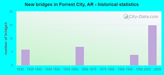
- New bridges - historical statistics
- 101930-1939
- 11940-1949
- 21950-1959
- 101960-1969
- 11970-1979
- 21980-1989
- 71990-1999
- 202000-2009
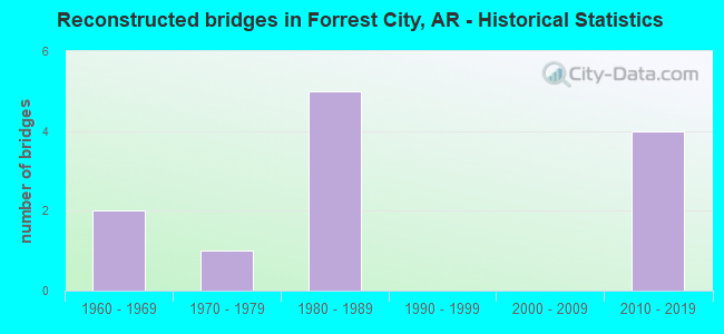
- Reconstructed bridges - Historical Statistics
- 21960-1969
- 11970-1979
- 51980-1989
- 01990-1999
- 02000-2009
- 42010-2019
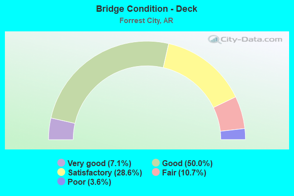
- Bridge Condition - Deck
- 7.1%Very good
- 50.0%Good
- 28.6%Satisfactory
- 10.7%Fair
- 3.6%Poor
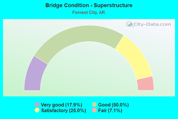
- Bridge Condition - Superstructure
- 17.9%Very good
- 50.0%Good
- 25.0%Satisfactory
- 7.1%Fair
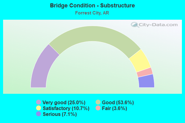
- Bridge Condition - Substructure
- 25.0%Very good
- 53.6%Good
- 10.7%Satisfactory
- 3.6%Fair
- 7.1%Serious
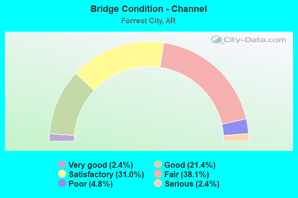
- Bridge Condition - Channel
- 2.4%Very good
- 21.4%Good
- 31.0%Satisfactory
- 38.1%Fair
- 4.8%Poor
- 2.4%Serious
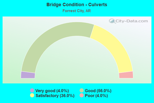
- Bridge Condition - Culverts
- 4.0%Very good
- 56.0%Good
- 36.0%Satisfactory
- 4.0%Poor
Find on map >> Show street view
Structure Number: X1172, Location: 1.9 Mi North Of Jct Sh 1B (Lat: 34.967622, Lng: -90.812339), Route carried "on" structure: State highway 1, Year Built: 2003, Status: Open, Structure Length: 1.31m (4.30ft), Average Daily Traffic: 3,176 (year 2018), Truck Traffic: 12%, Average Future Daily Traffic: 2,299 (year 2028), Design Load: H 20, Features Intersected: Ditch
Minimum Vertical Clearance: 30+ m (98+ ft), Kilometerpoint: 8.304, Lanes on structure: 2, Base Highway Network: Yes, Owner: State Highway Agency, Approaching Roadway Width: 11.0m (36.1ft), Skew: 3 degrees, Material/Design: Concrete, Design/Construction: Culvert, Number Of Spans In Main Unit: 4, Length of Maximum Span: 3.0m (9.8ft)
Condition: Channel: Fair, Culverts: Good, Operating Rating: 47.2 metric tons, Method Used To Determine Operating Rating: Load Factor (LF), Inventory Rating: 28.1 metric tons, Method Used To Determine Inventory Rating: Load Factor (LF), Structural Evaluation: Better than present minimum criteria, Waterway Adequacy: Equal to present desirable criteria, Approach Roadway Alignment: Equal to present desirable criteria, Designated Inspection Frequency: Every 24 months, Critical Feature Inspection Frequency: Every 24 months, Inspection Date: August 2021
Find on map >> Show street view
Structure Number: X1173, Location: 2.4 Mi North Of Jct SH 1B (Lat: 34.981178, Lng: -90.813997), Route carried "on" structure: State highway 1, Year Built: 2003, Status: Open, Structure Length: 1.07m (3.51ft), Average Daily Traffic: 3,200 (year 2018), Truck Traffic: 12%, Average Future Daily Traffic: 4,200 (year 2038), Design Load: H 20, Features Intersected: Ditch
Minimum Vertical Clearance: 30+ m (98+ ft), Kilometerpoint: 9.897, Lanes on structure: 2, Base Highway Network: Yes, Owner: State Highway Agency, Approaching Roadway Width: 12.2m (40.0ft), Skew: 4 degrees, Material/Design: Concrete, Design/Construction: Culvert, Number Of Spans In Main Unit: 2, Length of Maximum Span: 5.2m (17.1ft)
Condition: Channel: Fair, Culverts: Good, Operating Rating: 31.8 metric tons, Method Used To Determine Operating Rating: Load Factor (LF), Inventory Rating: 19.1 metric tons, Method Used To Determine Inventory Rating: Load Factor (LF), Structural Evaluation: Somewhat better than minimum adequacy, Waterway Adequacy: Equal to present desirable criteria, Approach Roadway Alignment: Equal to present desirable criteria, Designated Inspection Frequency: Every 24 months, Critical Feature Inspection Frequency: Every 24 months, Inspection Date: April 2020
Find on map >> Show street view
Structure Number: X1174, Location: NB Exit Ramp to US 70 (Lat: 34.993800, Lng: -90.815267), Route carried "on" structure: Ramp State highway 1, Year Built: 2003, Status: Open, Structure Length: 0.94m (3.08ft), Average Daily Traffic: 734 (year 2005), Truck Traffic: 1%, Average Future Daily Traffic: 605 (year 2025), Design Load: H 20, Features Intersected: Ditch
Minimum Vertical Clearance: 30+ m (98+ ft), Kilometerpoint: 11.217, Lanes on structure: 2, Base Highway Network: Yes, Owner: State Highway Agency, Approaching Roadway Width: 17.0m (55.8ft), Material/Design: Concrete, Design/Construction: Culvert, Number Of Spans In Main Unit: 4, Length of Maximum Span: 1.8m (5.9ft)
Condition: Channel: Satisfactory, Culverts: Good, Operating Rating: 34.5 metric tons, Method Used To Determine Operating Rating: Load Factor (LF), Inventory Rating: 20.9 metric tons, Method Used To Determine Inventory Rating: Load Factor (LF), Structural Evaluation: Somewhat better than minimum adequacy, Waterway Adequacy: Equal to present desirable criteria, Approach Roadway Alignment: Equal to present minimum criteria, Designated Inspection Frequency: Every 24 months, Critical Feature Inspection Frequency: Every 24 months, Inspection Date: April 2020
Find on map >> Show street view
Structure Number: X1175, Location: 2.07 Miles North Of Us 70 (Lat: 35.024472, Lng: -90.816361), Route carried "on" structure: Ramp State highway 1, Year Built: 2003, Status: Open, Structure Length: 1.83m (6.00ft), Average Daily Traffic: 640 (year 2019), Truck Traffic: 1%, Average Future Daily Traffic: 4,235 (year 2028), Design Load: H 20, Features Intersected: Ditch
Minimum Vertical Clearance: 30+ m (98+ ft), Kilometerpoint: 3.315, Lanes on structure: 1, Base Highway Network: Yes, Owner: State Highway Agency, Approaching Roadway Width: 7.9m (25.9ft), Skew: 1 degrees, Material/Design: Concrete, Design/Construction: Culvert, Number Of Spans In Main Unit: 5, Length of Maximum Span: 3.7m (12.1ft)
Condition: Channel: Good, Culverts: Good, Operating Rating: 41.7 metric tons, Method Used To Determine Operating Rating: Load Factor (LF), Inventory Rating: 25.4 metric tons, Method Used To Determine Inventory Rating: Load Factor (LF), Structural Evaluation: Equal to present minimum criteria, Waterway Adequacy: Equal to present desirable criteria, Approach Roadway Alignment: Better than present minimum criteria, Designated Inspection Frequency: Every 24 months, Critical Feature Inspection Frequency: Every 24 months, Inspection Date: October 2020
Find on map >> Show street view
Structure Number: X1176, Location: 2.32 Miles North Of Us 70 (Lat: 35.029017, Lng: -90.813911), Route carried "on" structure: Ramp Interstate 40, Year Built: 2003, Status: Open, Structure Length: 0.91m (2.99ft), Average Daily Traffic: 570 (year 2019), Truck Traffic: 1%, Average Future Daily Traffic: 2,420 (year 2028), Design Load: H 20, Features Intersected: Ditch
Minimum Vertical Clearance: 30.17m (98.98ft), Kilometerpoint: 385.068, Lanes on structure: 1, Base Highway Network: Yes, Owner: State Highway Agency, Approaching Roadway Width: 7.9m (25.9ft), Skew: 3 degrees, Material/Design: Concrete, Design/Construction: Culvert, Number Of Spans In Main Unit: 3, Length of Maximum Span: 3.0m (9.8ft)
Condition: Channel: Fair, Culverts: Good, Operating Rating: 42.6 metric tons, Method Used To Determine Operating Rating: Load Factor (LF), Inventory Rating: 25.4 metric tons, Method Used To Determine Inventory Rating: Load Factor (LF), Structural Evaluation: Equal to present minimum criteria, Waterway Adequacy: Equal to present desirable criteria, Approach Roadway Alignment: Equal to present desirable criteria, Designated Inspection Frequency: Every 24 months, Critical Feature Inspection Frequency: Every 24 months, Inspection Date: October 2020
Find on map >> Show street view
Structure Number: X1177, Location: 2.27 Miles North Of Us 70 (Lat: 35.026958, Lng: -90.818550), Route carried "on" structure: Ramp State highway 1, Year Built: 2003, Status: Open, Structure Length: 1.83m (6.00ft), Average Daily Traffic: 800 (year 2019), Truck Traffic: 1%, Average Future Daily Traffic: 2,420 (year 2028), Design Load: H 20, Features Intersected: Ditch
Minimum Vertical Clearance: 30.17m (98.98ft), Kilometerpoint: 3.653, Lanes on structure: 1, Base Highway Network: Yes, Owner: State Highway Agency, Approaching Roadway Width: 7.9m (25.9ft), Material/Design: Concrete, Design/Construction: Culvert, Number Of Spans In Main Unit: 5, Length of Maximum Span: 3.7m (12.1ft)
Condition: Channel: Good, Culverts: Satisfactory, Operating Rating: 41.7 metric tons, Method Used To Determine Operating Rating: Load Factor (LF), Inventory Rating: 25.4 metric tons, Method Used To Determine Inventory Rating: Load Factor (LF), Structural Evaluation: Equal to present minimum criteria, Waterway Adequacy: Equal to present desirable criteria, Approach Roadway Alignment: Equal to present desirable criteria, Designated Inspection Frequency: Every 24 months, Critical Feature Inspection Frequency: Every 24 months, Inspection Date: October 2020
Find on map >> Show street view
Structure Number: X1178, Location: 0.97 Miles North Of Us 70 (Lat: 35.008528, Lng: -90.816878), Route carried "on" structure: State highway 1, Year Built: 2003, Status: Open, Structure Length: 0.73m (2.40ft), Average Daily Traffic: 3,700 (year 2019), Truck Traffic: 16%, Average Future Daily Traffic: 5,300 (year 2038), Design Load: H 20, Features Intersected: Ditch
Minimum Vertical Clearance: 30.17m (98.98ft), Kilometerpoint: 1.561, Lanes on structure: 2, Base Highway Network: Yes, Owner: State Highway Agency, Approaching Roadway Width: 12.2m (40.0ft), Material/Design: Concrete, Design/Construction: Culvert, Number Of Spans In Main Unit: 2, Length of Maximum Span: 3.7m (12.1ft)
Condition: Channel: Fair, Culverts: Good, Operating Rating: 31.8 metric tons, Method Used To Determine Operating Rating: Load Factor (LF), Inventory Rating: 19.1 metric tons, Method Used To Determine Inventory Rating: Load Factor (LF), Structural Evaluation: Somewhat better than minimum adequacy, Waterway Adequacy: Equal to present desirable criteria, Approach Roadway Alignment: Equal to present desirable criteria, Designated Inspection Frequency: Every 24 months, Critical Feature Inspection Frequency: Every 24 months, Inspection Date: October 2020
Find on map >> Show street view
Structure Number: X1179, Location: 1.48 Miles North Of Us 70 (Lat: 35.015819, Lng: -90.816811), Route carried "on" structure: State highway 1, Year Built: 2003, Status: Open, Structure Length: 1.46m (4.79ft), Average Daily Traffic: 3,700 (year 2019), Truck Traffic: 16%, Average Future Daily Traffic: 5,300 (year 2038), Design Load: H 20, Features Intersected: Ditch
Minimum Vertical Clearance: 30.17m (98.98ft), Kilometerpoint: 2.382, Lanes on structure: 2, Base Highway Network: Yes, Owner: State Highway Agency, Approaching Roadway Width: 12.2m (40.0ft), Material/Design: Concrete, Design/Construction: Culvert, Number Of Spans In Main Unit: 4, Length of Maximum Span: 3.7m (12.1ft)
Condition: Channel: Good, Culverts: Good, Operating Rating: 31.8 metric tons, Method Used To Determine Operating Rating: Load Factor (LF), Inventory Rating: 19.1 metric tons, Method Used To Determine Inventory Rating: Load Factor (LF), Structural Evaluation: Somewhat better than minimum adequacy, Waterway Adequacy: Equal to present desirable criteria, Approach Roadway Alignment: Superior to present desirable criteria, Designated Inspection Frequency: Every 24 months, Critical Feature Inspection Frequency: Every 24 months, Inspection Date: October 2020
Find on map >> Show street view
Structure Number: X118, Location: 2.76 Miles North Of Us 70 (Lat: 35.034383, Lng: -90.816611), Route carried "on" structure: State highway 1, Year Built: 2003, Status: Open, Structure Length: 0.91m (2.99ft), Average Daily Traffic: 3,600 (year 2019), Truck Traffic: 1%, Average Future Daily Traffic: 2,420 (year 2028), Design Load: H 20, Features Intersected: Ditch
Minimum Vertical Clearance: 30.17m (98.98ft), Kilometerpoint: 4.442, Lanes on structure: 2, Base Highway Network: Yes, Owner: State Highway Agency, Approaching Roadway Width: 12.2m (40.0ft), Material/Design: Concrete, Design/Construction: Culvert, Number Of Spans In Main Unit: 3, Length of Maximum Span: 3.0m (9.8ft)
Condition: Channel: Satisfactory, Culverts: Satisfactory, Operating Rating: 39.9 metric tons, Method Used To Determine Operating Rating: Load Factor (LF), Inventory Rating: 23.6 metric tons, Method Used To Determine Inventory Rating: Load Factor (LF), Structural Evaluation: Equal to present minimum criteria, Waterway Adequacy: Equal to present desirable criteria, Approach Roadway Alignment: Superior to present desirable criteria, Designated Inspection Frequency: Every 24 months, Critical Feature Inspection Frequency: Every 24 months, Inspection Date: October 2020
Find on map >> Show street view
Structure Number: X1181, Location: 3.02 Miles North Of Us 70 (Lat: 35.038133, Lng: -90.816567), Route carried "on" structure: State highway 1, Year Built: 2003, Status: Open, Structure Length: 1.46m (4.79ft), Average Daily Traffic: 3,600 (year 2019), Truck Traffic: 1%, Average Future Daily Traffic: 2,420 (year 2028), Design Load: H 20, Features Intersected: Ditch
Minimum Vertical Clearance: 30.17m (98.98ft), Kilometerpoint: 4.860, Lanes on structure: 2, Base Highway Network: Yes, Owner: State Highway Agency, Approaching Roadway Width: 12.8m (42.0ft), Material/Design: Concrete, Design/Construction: Culvert, Number Of Spans In Main Unit: 4, Length of Maximum Span: 3.7m (12.1ft)
Condition: Channel: Satisfactory, Culverts: Satisfactory, Operating Rating: 31.8 metric tons, Method Used To Determine Operating Rating: Load Factor (LF), Inventory Rating: 19.1 metric tons, Method Used To Determine Inventory Rating: Load Factor (LF), Structural Evaluation: Somewhat better than minimum adequacy, Waterway Adequacy: Better than present minimum criteria, Approach Roadway Alignment: Superior to present desirable criteria, Designated Inspection Frequency: Every 24 months, Critical Feature Inspection Frequency: Every 24 months, Inspection Date: October 2020
Find on map >> Show street view
Structure Number: X1182, Location: 3.52 Miles North Of Us 70 (Lat: 35.045447, Lng: -90.816489), Route carried "on" structure: State highway 1, Year Built: 2003, Status: Open, Structure Length: 0.91m (2.99ft), Average Daily Traffic: 3,600 (year 2019), Truck Traffic: 1%, Average Future Daily Traffic: 2,420 (year 2028), Design Load: H 20, Features Intersected: Ditch
Minimum Vertical Clearance: 30.17m (98.98ft), Kilometerpoint: 5.665, Lanes on structure: 2, Base Highway Network: Yes, Owner: State Highway Agency, Approaching Roadway Width: 12.8m (42.0ft), Material/Design: Concrete, Design/Construction: Culvert, Number Of Spans In Main Unit: 3, Length of Maximum Span: 3.0m (9.8ft)
Condition: Channel: Satisfactory, Culverts: Satisfactory, Operating Rating: 39.9 metric tons, Method Used To Determine Operating Rating: Load Factor (LF), Inventory Rating: 23.6 metric tons, Method Used To Determine Inventory Rating: Load Factor (LF), Structural Evaluation: Equal to present minimum criteria, Waterway Adequacy: Equal to present desirable criteria, Approach Roadway Alignment: Equal to present desirable criteria, Designated Inspection Frequency: Every 24 months, Critical Feature Inspection Frequency: Every 24 months, Inspection Date: October 2020
Find on map >> Show street view
Structure Number: 1572, Location: 1.07 Miles West Jct Sh 1 (Lat: 35.003381, Lng: -90.799539), Route carried "under" structure: US 70, Structure Length: 0. m, Average Daily Traffic: 9,300 (year 2014), Truck Traffic: 1%, Features Intersected: Us-70/Sec-18/L19.34, Facility Carried by Structure: CRI&P RR
Minimum Vertical Clearance: 4.30m (14.11ft), Kilometerpoint: 31.125, Length of Maximum Span: 0.0m
Find on map >> Show street view
Structure Number: 3615, Location: 2.02 Miles West Of Sh 1 (Lat: 35.023500, Lng: -90.822478), Route carried "under" structure: Interstate 40, Structure Length: 0. m, Average Daily Traffic: 14,500 (year 2014), Truck Traffic: 1%, Features Intersected: I 40-SEC 51, Facility Carried by Structure: Cr-224/Z-F/L-6.67
Minimum Vertical Clearance: 5.07m (16.63ft), Kilometerpoint: 384.118, Length of Maximum Span: 0.0m
Find on map >> Show street view
Structure Number: 3615, Location: 2.02 Miles West Of Sh 1 (Lat: 35.023500, Lng: -90.822478), Route carried "under" structure: Interstate 40, Structure Length: 0. m, Average Daily Traffic: 14,500 (year 2014), Truck Traffic: 1%, Features Intersected: I 40-SEC 51, Facility Carried by Structure: Cr-224/Z-F/L-6.67
Minimum Vertical Clearance: 5.29m (17.36ft), Kilometerpoint: 384.118, Length of Maximum Span: 0.0m
Find on map >> Show street view
Structure Number: 3776, Location: 3.28 Mi East Of Sh 261 (Lat: 35.004081, Lng: -90.852919), Route carried "under" structure: Interstate 40, Structure Length: 0. m, Average Daily Traffic: 33,000 (year 2019), Truck Traffic: 65%, Features Intersected: I-40WB/Sec-51/L-236.41, Facility Carried by Structure: Cr-219/Z-F/L-0.14
Minimum Vertical Clearance: 5.03m (16.50ft), Kilometerpoint: 380.465, Length of Maximum Span: 0.0m
Find on map >> Show street view
Structure Number: 3776, Location: 3.28 Mi East Of Sh 261 (Lat: 35.004081, Lng: -90.852919), Route carried "under" structure: Interstate 40, Structure Length: 0. m, Average Daily Traffic: 33,000 (year 2014), Truck Traffic: 65%, Features Intersected: I-40EB/Sec-51/L-236.41, Facility Carried by Structure: Cr-219/Z-F/L-0.14
Minimum Vertical Clearance: 5.16m (16.93ft), Kilometerpoint: 380.465, Length of Maximum Span: 0.0m
Find on map >> Show street view
Structure Number: 19499, Location: 0.12 Miles South Of Us 70 (Lat: 35.006203, Lng: -90.789742), Route carried "under" structure: City street 16040, Structure Length: 0. m, Average Daily Traffic: 3,245 (year 1983), Truck Traffic: 1%, Features Intersected: Division Street Forest C, Facility Carried by Structure: Union Pacific RR
Minimum Vertical Clearance: 4.75m (15.58ft), Kilometerpoint: 0.193, Length of Maximum Span: 0.0m
Find on map >> Show street view
Structure Number: A362, Location: 1 Mile East Of Jct Sh 1 (Lat: 35.037725, Lng: -90.772094), Route carried "under" structure: State highway 284, Structure Length: 0. m, Average Daily Traffic: 2,500 (year 2014), Truck Traffic: 1%, Features Intersected: Sh-284/Sec-3/L-9.24, Facility Carried by Structure: I-40WB/Se51/241.77
Minimum Vertical Clearance: 4.34m (14.24ft), Kilometerpoint: 14.903, Length of Maximum Span: 0.0m
Find on map >> Show street view
Structure Number: A6522, Location: 0.72 Miles West Jct Sh 1 (Lat: 35.033900, Lng: -90.803400), Route carried "under" structure: City street 14910, Structure Length: 0. m, Average Daily Traffic: 1,400 (year 2019), Truck Traffic: 40%, Features Intersected: Dawson-RR/Z-F/L-1.88, Facility Carried by Structure: I-40WB/Se51/239.89
Minimum Vertical Clearance: 7.16m (23.49ft), Kilometerpoint: 3.026, Length of Maximum Span: 0.0m
Find on map >> Show street view
Structure Number: A6523, Location: At Jct Sh 1 Forrest City (Lat: 35.036469, Lng: -90.790122), Route carried "under" structure: Business State highway 1, Structure Length: 0. m, Average Daily Traffic: 14,000 (year 2015), Truck Traffic: 40%, Features Intersected: Sh-1BSec-12/L-1.91
Minimum Vertical Clearance: 5.11m (16.77ft), Kilometerpoint: 3.074, Length of Maximum Span: 0.0m
Find on map >> Show street view
Structure Number: A6523, Location: At Jct Sh 1 Forrest City (Lat: 35.036469, Lng: -90.790122), Route carried "under" structure: Business State highway 1, Structure Length: 0. m, Average Daily Traffic: 14,000 (year 2019), Truck Traffic: 40%, Features Intersected: Sh-1BSec-12/L-1.91
Minimum Vertical Clearance: 5.62m (18.44ft), Kilometerpoint: 3.074, Length of Maximum Span: 0.0m
Find on map >> Show street view
Structure Number: B362, Location: 1.03 Mi East Of Jct Sh 1 (Lat: 35.037478, Lng: -90.772125), Route carried "under" structure: State highway 284, Structure Length: 0. m, Average Daily Traffic: 2,500 (year 2014), Truck Traffic: 1%, Features Intersected: Sh-284/Sec-3/L-9.24, Facility Carried by Structure: I-40EB/Se51/241.77
Minimum Vertical Clearance: 4.34m (14.24ft), Kilometerpoint: 14.919, Length of Maximum Span: 0.0m
Find on map >> Show street view
Structure Number: B6522, Location: 0.77 Mi West Of Jct Sh 1 (Lat: 35.033692, Lng: -90.803308), Route carried "under" structure: City street 14910, Structure Length: 0. m, Average Daily Traffic: 1,400 (year 2019), Truck Traffic: 40%, Features Intersected: Dawson/Z-F/L-0.01, Facility Carried by Structure: I-40EB/Se51/239.89
Minimum Vertical Clearance: 7.06m (23.16ft), Kilometerpoint: 0.016, Length of Maximum Span: 0.0m
Find on map >> Show street view
Structure Number: B6523, Location: Forest City Jct Sh 1 (Lat: 35.036228, Lng: -90.790122), Route carried "under" structure: Business State highway 1, Structure Length: 0. m, Average Daily Traffic: 14,000 (year 2019), Truck Traffic: 40%, Features Intersected: Sh-1B/Sec-12/L-1.92
Minimum Vertical Clearance: 5.62m (18.44ft), Kilometerpoint: 3.090, Length of Maximum Span: 0.0m
Find on map >> Show street view
Structure Number: B6523, Location: Forest City Jct Sh 1 (Lat: 35.036228, Lng: -90.790122), Route carried "under" structure: Business State highway 1, Structure Length: 0. m, Average Daily Traffic: 1,400 (year 2019), Truck Traffic: 40%, Features Intersected: Sh-1B/Sec-12/L-1.92
Minimum Vertical Clearance: 5.13m (16.83ft), Kilometerpoint: 3.090, Length of Maximum Span: 0.0m
Find on map >> Show street view
Structure Number: B677, Location: 2.18 Miles North Of Sh 70 (Lat: 35.025989, Lng: -90.816703), Route carried "under" structure: Interstate 40, Structure Length: 0. m, Average Daily Traffic: 33,000 (year 2019), Truck Traffic: 65%, Features Intersected: I-40/Sec-51/L-238.69, Facility Carried by Structure: Sh-1/Sec-12/L-2.18
Minimum Vertical Clearance: 5.09m (16.70ft), Kilometerpoint: 384.134, Length of Maximum Span: 0.0m
Find on map >> Show street view
Structure Number: B677, Location: 2.18 Miles North Of Sh 70 (Lat: 35.025989, Lng: -90.816703), Route carried "under" structure: Interstate 40, Structure Length: 0. m, Average Daily Traffic: 33,000 (year 2019), Truck Traffic: 65%, Features Intersected: I-40/Sec-51/L-238.69, Facility Carried by Structure: Sh-1/Sec-12/L-2.18
Minimum Vertical Clearance: 5.04m (16.54ft), Kilometerpoint: 384.134, Length of Maximum Span: 0.0m
Find on map >> Show street view
Structure Number: B6801, Location: 0.18 Miles North Of Sh 70 (Lat: 34.997017, Lng: -90.818181), Route carried "under" structure: County highway 200, Structure Length: 0. m, Average Daily Traffic: 144 (year 1984), Truck Traffic: 1%, Features Intersected: Union Pac. RR & Cr 200, Facility Carried by Structure: Sh-1/Sec-12/L-0.18
Minimum Vertical Clearance: 9.05m (29.69ft), Kilometerpoint: 0.290, Length of Maximum Span: 0.0m
Find on map >> Show street view
Structure Number: B6802, Location: 6.9 Miles North Of Sh 1B (Lat: 34.993800, Lng: -90.817450), Route carried "under" structure: US 70, Structure Length: 0. m, Average Daily Traffic: 5,900 (year 2014), Truck Traffic: 1%, Features Intersected: Us-70/Sec-18/L-18.1, Facility Carried by Structure: Sh-1/Sec-11/L-6.98
Minimum Vertical Clearance: 5.38m (17.65ft), Kilometerpoint: 29.129, Length of Maximum Span: 0.0m