Bridge Statistics for Fort Lauderdale, Florida (FL)
Condition, Traffic, Stress, Structural Evaluation, Project Costs
- National Bridge Inventory (NBI) Statistics
- 213Number of bridges
- 5,591ft / 1,704mTotal length
- $743,000Total costs
- 6,288,142Total average daily traffic
- 490,624Total average daily truck traffic
- National Bridge Inventory (NBI) Registered Bridges for Fort Lauderdale
- No street view available for this location
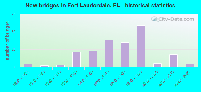
- New bridges - historical statistics
- 41920-1929
- 21930-1939
- 31940-1949
- 211950-1959
- 231960-1969
- 391970-1979
- 351980-1989
- 591990-1999
- 52000-2009
- 182010-2019
- 42020-2022
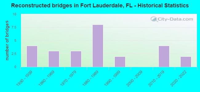
- Reconstructed bridges - Historical Statistics
- 41950-1959
- 31960-1969
- 31970-1979
- 81980-1989
- 21990-1999
- 02000-2009
- 42010-2019
- 22020-2022
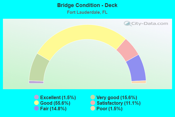
- Bridge Condition - Deck
- 1.5%Excellent
- 15.6%Very good
- 55.6%Good
- 11.1%Satisfactory
- 14.8%Fair
- 1.5%Poor
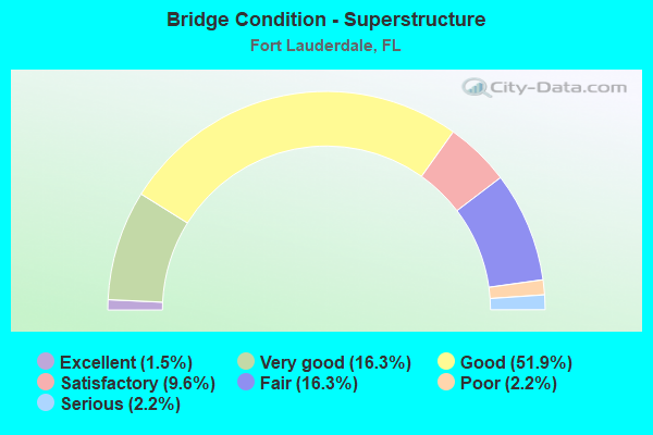
- Bridge Condition - Superstructure
- 1.5%Excellent
- 16.3%Very good
- 51.9%Good
- 9.6%Satisfactory
- 16.3%Fair
- 2.2%Poor
- 2.2%Serious
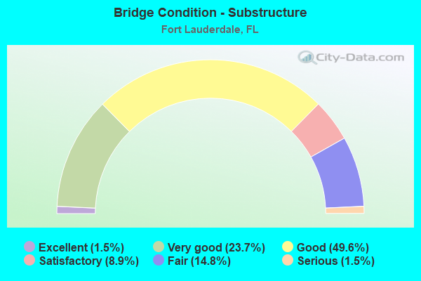
- Bridge Condition - Substructure
- 1.5%Excellent
- 23.7%Very good
- 49.6%Good
- 8.9%Satisfactory
- 14.8%Fair
- 1.5%Serious
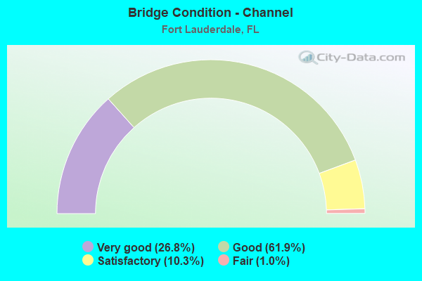
- Bridge Condition - Channel
- 26.8%Very good
- 61.9%Good
- 10.3%Satisfactory
- 1.0%Fair
Find on map >> Show street view
Structure Number: 860523, Location: WB SR 84 / ( I-95) (Lat: 26.088639, Lng: -80.168419), Route carried "on" structure: State highway 84, Year Built: 1990, Status: Open, Structure Length: 5.33m (17.49ft), Average Daily Traffic: 15,000 (year 2020), Truck Traffic: 8%, Average Future Daily Traffic: 26,025 (year 2042), Design Load: HS 20, Features Intersected: I-95 (SR-9)
Minimum Vertical Clearance: 5.03m (16.50ft), Kilometerpoint: 0.465, Lanes on structure: 4, Lanes under structure: 8, Owner: State Highway Agency, Approaching Roadway Width: 20.8m (68.2ft), Skew: 21 degrees, Material/Design: Steel, Design/Construction: Box Beam or Girders - Single/Spread, Number Of Spans In Main Unit: 1, Length of Maximum Span: 53.3m (174.9ft), Curb-To-Curb Width: 20.9m (68.6ft), Out-to-Out Width: 21.7m (71.2ft)
Condition: Deck: Good, Superstructure: Good, Substructure: Very good, Operating Rating: 86.5 metric tons, Method Used To Determine Operating Rating: Load Factor (LF), Inventory Rating: 51.9 metric tons, Method Used To Determine Inventory Rating: Load Factor (LF), Structural Evaluation: Better than present minimum criteria, Deck Geometry: Superior to present desirable criteria, Underclear: High priority of corrective action, Approach Roadway Alignment: Equal to present desirable criteria, Designated Inspection Frequency: Every 24 months, Inspection Date: Febuary 2020, Deck Structure Type: Concrete Cast-file-Place
Find on map >> Show street view
Structure Number: 860524, Location: I-95 / SR 84 interchange (Lat: 26.088897, Lng: -80.167447), Route carried "on" structure: State highway 84, Year Built: 1990, Status: Open, Structure Length: 9.08m (29.79ft), Average Daily Traffic: 15,000 (year 2022), Truck Traffic: 8%, Average Future Daily Traffic: 26,025 (year 2042), Design Load: HS 20, Features Intersected: I-595 Ramps to I-95 NB
Minimum Vertical Clearance: 30+ m (98+ ft), Kilometerpoint: 0.335, Lanes on structure: 4, Lanes under structure: 5, Owner: State Highway Agency, Approaching Roadway Width: 17.7m (58.1ft), Skew: 21 degrees, Material/Design: Steel continuous, Design/Construction: Box Beam or Girders - Single/Spread, Number Of Spans In Main Unit: 2, Length of Maximum Span: 49.3m (161.7ft), Curb-To-Curb Width: 22.9m (75.1ft), Out-to-Out Width: 23.7m (77.8ft)
Condition: Deck: Good, Superstructure: Good, Substructure: Good, Operating Rating: 58.4 metric tons, Method Used To Determine Operating Rating: Load Factor (LF), Inventory Rating: 34.9 metric tons, Method Used To Determine Inventory Rating: Load Factor (LF), Structural Evaluation: Better than present minimum criteria, Deck Geometry: Superior to present desirable criteria, Underclear: Somewhat better than minimum adequacy, Approach Roadway Alignment: Equal to present desirable criteria, Designated Inspection Frequency: Every 24 months, Inspection Date: Febuary 2022, Deck Structure Type: Concrete Cast-file-Place, Wearing Surface/Protective System: Wearing Surface: Epoxy Overlay
Find on map >> Show street view
Structure Number: 860525, Location: I-95 (SR-9) at SR-84 (Lat: 26.088567, Lng: -80.167797), Route carried "on" structure: Ramp Interstate 95, Year Built: 1990, Status: Open, Structure Length: 9.21m (30.22ft), Average Daily Traffic: 8,700 (year 2020), Truck Traffic: 8%, Average Future Daily Traffic: 15,094 (year 2042), Design Load: HS 20+Mod, Features Intersected: I-595 & SR-84 Connectors
Minimum Vertical Clearance: 30+ m (98+ ft), Kilometerpoint: 0.496, Lanes on structure: 1, Lanes under structure: 5, Owner: State Highway Agency, Approaching Roadway Width: 8.2m (26.9ft), Skew: 1 degrees, Material/Design: Steel continuous, Design/Construction: Box Beam or Girders - Single/Spread, Number Of Spans In Main Unit: 2, Length of Maximum Span: 50.1m (164.4ft), Curb-To-Curb Width: 8.2m (26.9ft), Out-to-Out Width: 9.1m (29.9ft)
Condition: Deck: Good, Superstructure: Good, Substructure: Good, Operating Rating: 44.7 metric tons, Method Used To Determine Operating Rating: Load and Resistance Factor (LRFR), Inventory Rating: 34.7 metric tons, Method Used To Determine Inventory Rating: Load and Resistance Factor (LRFR), Structural Evaluation: Better than present minimum criteria, Deck Geometry: Superior to present desirable criteria, Underclear: Somewhat better than minimum adequacy, Approach Roadway Alignment: Equal to present minimum criteria, Designated Inspection Frequency: Every 24 months, Critical Feature Inspection Frequency: Every 24 months, Inspection Date: Febuary 2022, Critical Feature Inspection Date: Febuary 2022, Deck Structure Type: Concrete Cast-file-Place, Wearing Surface/Protective System: Wearing Surface: Epoxy Overlay
Find on map >> Show street view
Structure Number: 860526, Location: SR-84& I-95 Interchange (Lat: 26.089278, Lng: -80.168722), Route carried "on" structure: Ramp Interstate 95, Year Built: 1990, Status: Closed, Structure Length: 19.01m (62.37ft), Average Daily Traffic: 13,000 (year 2022), Truck Traffic: 8%, Average Future Daily Traffic: 22,555 (year 2042), Design Load: HS 20, Features Intersected: SR-84 WB
Minimum Vertical Clearance: 30+ m (98+ ft), Kilometerpoint: 0.301, Lanes on structure: 1, Lanes under structure: 4, Owner: State Highway Agency, Approaching Roadway Width: 8.6m (28.2ft), Skew: 9 degrees, Material/Design: Steel continuous, Design/Construction: Box Beam or Girders - Single/Spread, Number Of Spans In Main Unit: 5, Length of Maximum Span: 40.2m (131.9ft), Curb-To-Curb Width: 11.0m (36.1ft), Out-to-Out Width: 11.8m (38.7ft)
Condition: Deck: Satisfactory, Superstructure: Good, Substructure: Good, Operating Rating: 40.8 metric tons, Method Used To Determine Operating Rating: Load and Resistance Factor (LRFR), Inventory Rating: 31.4 metric tons, Method Used To Determine Inventory Rating: Load and Resistance Factor (LRFR), Structural Evaluation: Better than present minimum criteria, Deck Geometry: Superior to present desirable criteria, Underclear: Somewhat better than minimum adequacy, Approach Roadway Alignment: Equal to present desirable criteria, Designated Inspection Frequency: Every 24 months, Critical Feature Inspection Frequency: Every 24 months, Inspection Date: January 2022, Critical Feature Inspection Date: January 2022, Deck Structure Type: Concrete Cast-file-Place, Wearing Surface/Protective System: Wearing Surface: Epoxy Overlay
Find on map >> Show street view
Structure Number: 860527, Location: SR-84 & I-95 Interchange (Lat: 26.089375, Lng: -80.168083), Route carried "on" structure: Ramp Interstate 95, Year Built: 1990, Status: Open, Structure Length: 19.07m (62.57ft), Average Daily Traffic: 13,000 (year 2022), Truck Traffic: 8%, Average Future Daily Traffic: 22,555 (year 2042), Design Load: HS 20, Features Intersected: SR-84 WB
Minimum Vertical Clearance: 30+ m (98+ ft), Kilometerpoint: 0.008, Lanes on structure: 2, Lanes under structure: 4, Owner: State Highway Agency, Approaching Roadway Width: 11.0m (36.1ft), Skew: 9 degrees, Material/Design: Steel continuous, Design/Construction: Box Beam or Girders - Single/Spread, Number Of Spans In Main Unit: 5, Length of Maximum Span: 40.2m (131.9ft), Curb-To-Curb Width: 11.0m (36.1ft), Out-to-Out Width: 11.9m (39.0ft)
Condition: Deck: Satisfactory, Superstructure: Good, Substructure: Good, Operating Rating: 44.1 metric tons, Method Used To Determine Operating Rating: Load and Resistance Factor (LRFR), Inventory Rating: 33.9 metric tons, Method Used To Determine Inventory Rating: Load and Resistance Factor (LRFR), Structural Evaluation: Better than present minimum criteria, Deck Geometry: Better than present minimum criteria, Underclear: Meets minimum limits, Approach Roadway Alignment: Equal to present desirable criteria, Designated Inspection Frequency: Every 24 months, Critical Feature Inspection Frequency: Every 24 months, Inspection Date: January 2022, Critical Feature Inspection Date: January 2022, Deck Structure Type: Concrete Cast-file-Place, Wearing Surface/Protective System: Wearing Surface: Epoxy Overlay
Find on map >> Show street view
Structure Number: 860528, Location: NORTH OF I-595 INTERCHANG (Lat: 26.087722, Lng: -80.171003), Route carried "on" structure: State highway 84, Year Built: 1988, Status: Open, Structure Length: 48.28m (158.40ft), Average Daily Traffic: 19,000 (year 2020), Truck Traffic: 9%, Average Future Daily Traffic: 32,965 (year 2042), Design Load: HS 20+Mod, Features Intersected: I-95 / RR / RAMPS
Minimum Vertical Clearance: 6.16m (20.21ft), Kilometerpoint: 28.215, Lanes on structure: 3, Lanes under structure: 3, Owner: State Highway Agency, Approaching Roadway Width: 16.5m (54.1ft), Skew: 29 degrees, Material/Design: Steel continuous, Design/Construction: Box Beam or Girders - Single/Spread, Number Of Spans In Main Unit: 5, Number Of Approach Spans: 8, Length of Maximum Span: 58.5m (191.9ft), Curb or Sidewalk Widths: Left: 0.0m, Right: 1.7m (5.6ft), Curb-To-Curb Width: 16.5m (54.1ft), Out-to-Out Width: 19.0m (62.3ft)
Condition: Deck: Good, Superstructure: Good, Substructure: Good, Operating Rating: 42.5 metric tons, Method Used To Determine Operating Rating: Load and Resistance Factor (LRFR), Inventory Rating: 32.3 metric tons, Method Used To Determine Inventory Rating: Load and Resistance Factor (LRFR), Structural Evaluation: Better than present minimum criteria, Deck Geometry: Better than present minimum criteria, Underclear: Somewhat better than minimum adequacy, Approach Roadway Alignment: Equal to present desirable criteria, Designated Inspection Frequency: Every 24 months, Inspection Date: Febuary 2022, Deck Structure Type: Concrete Cast-file-Place, Wearing Surface/Protective System: Wearing Surface: Epoxy Overlay
Find on map >> Show street view
Structure Number: 860535, Location: I-595 (SR-862) OVER I-95 (Lat: 26.082167, Lng: -80.167636), Route carried "on" structure: Interstate 595, Year Built: 1989, Status: Open, Structure Length: 36.50m (119.75ft), Average Daily Traffic: 25,250 (year 2022), Truck Traffic: 7%, Average Future Daily Traffic: 43,809 (year 2042), Design Load: HS 20+Mod, Features Intersected: I-95/RR/Anglers Ave.
Minimum Vertical Clearance: 5.15m (16.90ft), Kilometerpoint: 16.509, Lanes on structure: 2, Lanes under structure: 14, Base Highway Network: Yes, Owner: State Highway Agency, Approaching Roadway Width: 17.3m (56.8ft), Material/Design: Steel continuous, Design/Construction: Box Beam or Girders - Single/Spread, Number Of Spans In Main Unit: 10, Length of Maximum Span: 40.2m (131.9ft), Curb-To-Curb Width: 17.1m (56.1ft), Out-to-Out Width: 17.9m (58.7ft)
Condition: Deck: Good, Superstructure: Good, Substructure: Good, Operating Rating: 54.4 metric tons, Method Used To Determine Operating Rating: Load Testing, Inventory Rating: 32.7 metric tons, Method Used To Determine Inventory Rating: Load Testing, Structural Evaluation: Better than present minimum criteria, Deck Geometry: Equal to present minimum criteria, Underclear: Somewhat better than minimum adequacy, Approach Roadway Alignment: Equal to present desirable criteria, Designated Inspection Frequency: Every 24 months, Inspection Date: January 2022, Deck Structure Type: Concrete Cast-file-Place
Find on map >> Show street view
Structure Number: 860536, Location: I-595 SR-862 OVER I-95 (Lat: 26.082203, Lng: -80.171303), Route carried "on" structure: Interstate 595, Year Built: 1989, Status: Open, Structure Length: 36.50m (119.75ft), Average Daily Traffic: 25,250 (year 2022), Truck Traffic: 7%, Average Future Daily Traffic: 43,809 (year 2042), Design Load: HS 20, Features Intersected: I-95/RR/Anglers Ave.
Minimum Vertical Clearance: 5.18m (16.99ft), Kilometerpoint: 16.509, Lanes on structure: 3, Lanes under structure: 14, Base Highway Network: Yes, Owner: State Highway Agency, Approaching Roadway Width: 17.3m (56.8ft), Material/Design: Steel continuous, Design/Construction: Box Beam or Girders - Single/Spread, Number Of Spans In Main Unit: 10, Length of Maximum Span: 40.2m (131.9ft), Curb-To-Curb Width: 17.1m (56.1ft), Out-to-Out Width: 17.9m (58.7ft)
Condition: Deck: Good, Superstructure: Good, Substructure: Good, Operating Rating: 54.4 metric tons, Method Used To Determine Operating Rating: Load Testing, Inventory Rating: 33.2 metric tons, Method Used To Determine Inventory Rating: Load Testing, Structural Evaluation: Better than present minimum criteria, Deck Geometry: Equal to present minimum criteria, Underclear: Somewhat better than minimum adequacy, Approach Roadway Alignment: Equal to present desirable criteria, Designated Inspection Frequency: Every 24 months, Inspection Date: January 2022, Deck Structure Type: Concrete Cast-file-Place
Find on map >> Show street view
Structure Number: 860537, Location: I-95/I-595 Interchange (Lat: 26.083639, Lng: -80.170472), Route carried "on" structure: Ramp Interstate 595, Year Built: 1989, Status: Open, Structure Length: 21.18m (69.49ft), Average Daily Traffic: 46,500 (year 2022), Truck Traffic: 10%, Average Future Daily Traffic: 80,678 (year 2042), Design Load: HS 20+Mod, Features Intersected: Ravenswood Rd., CSXRR
Minimum Vertical Clearance: 30+ m (98+ ft), Kilometerpoint: 0.166, Lanes on structure: 2, Lanes under structure: 2, Owner: State Highway Agency, Approaching Roadway Width: 12.2m (40.0ft), Material/Design: Steel continuous, Design/Construction: Box Beam or Girders - Single/Spread, Number Of Spans In Main Unit: 5, Length of Maximum Span: 64.9m (212.9ft), Curb-To-Curb Width: 12.2m (40.0ft), Out-to-Out Width: 13.0m (42.7ft)
Condition: Deck: Good, Superstructure: Good, Substructure: Good, Operating Rating: 58.8 metric tons, Method Used To Determine Operating Rating: Load Testing, Inventory Rating: 35.9 metric tons, Method Used To Determine Inventory Rating: Load Testing, Structural Evaluation: Better than present minimum criteria, Deck Geometry: Superior to present desirable criteria, Underclear: Superior to present desirable criteria, Approach Roadway Alignment: Better than present minimum criteria, Designated Inspection Frequency: Every 24 months, Critical Feature Inspection Frequency: Every 24 months, Inspection Date: January 2022, Critical Feature Inspection Date: January 2022, Deck Structure Type: Concrete Cast-file-Place, Wearing Surface/Protective System: Wearing Surface: Epoxy Overlay
Find on map >> Show street view
Structure Number: 860539, Location: I-95 & I-595 Interchange (Lat: 26.083764, Lng: -80.167142), Route carried "on" structure: Ramp Interstate 595, Year Built: 1990, Status: Open, Structure Length: 23.46m (76.97ft), Average Daily Traffic: 9,900 (year 2020), Truck Traffic: 16%, Average Future Daily Traffic: 17,176 (year 2042), Design Load: HS 20+Mod, Features Intersected: SR9 (I-95) & E-N Conn.
Minimum Vertical Clearance: 5.08m (16.67ft), Kilometerpoint: 0.655, Lanes on structure: 2, Lanes under structure: 13, Owner: State Highway Agency, Approaching Roadway Width: 12.2m (40.0ft), Material/Design: Steel continuous, Design/Construction: Box Beam or Girders - Single/Spread, Number Of Spans In Main Unit: 5, Length of Maximum Span: 55.9m (183.4ft), Curb-To-Curb Width: 12.2m (40.0ft), Out-to-Out Width: 13.0m (42.7ft)
Condition: Deck: Good, Superstructure: Good, Substructure: Very good, Operating Rating: 57.2 metric tons, Method Used To Determine Operating Rating: Load Testing, Inventory Rating: 32.7 metric tons, Method Used To Determine Inventory Rating: Load Testing, Structural Evaluation: Better than present minimum criteria, Deck Geometry: Equal to present minimum criteria, Underclear: Somewhat better than minimum adequacy, Approach Roadway Alignment: Equal to present desirable criteria, Designated Inspection Frequency: Every 24 months, Critical Feature Inspection Frequency: Every 24 months, Inspection Date: March 2020, Critical Feature Inspection Date: March 2020, Deck Structure Type: Concrete Cast-file-Place
Find on map >> Show street view
Structure Number: 86054, Location: I-95/I-595 Interchange (Lat: 26.081444, Lng: -80.170139), Route carried "on" structure: Ramp Interstate 595, Year Built: 1988, Status: Open, Structure Length: 25.30m (83.01ft), Average Daily Traffic: 26,500 (year 2022), Truck Traffic: 10%, Average Future Daily Traffic: 45,978 (year 2042), Design Load: HS 20+Mod, Features Intersected: Ramp, Anglers + RR
Minimum Vertical Clearance: 30+ m (98+ ft), Kilometerpoint: 0.006, Lanes on structure: 2, Lanes under structure: 4, Owner: State Highway Agency, Approaching Roadway Width: 12.2m (40.0ft), Material/Design: Steel continuous, Design/Construction: Box Beam or Girders - Single/Spread, Number Of Spans In Main Unit: 6, Length of Maximum Span: 54.2m (177.8ft), Curb-To-Curb Width: 12.2m (40.0ft), Out-to-Out Width: 13.0m (42.7ft)
Condition: Deck: Good, Superstructure: Good, Substructure: Good, Operating Rating: 57.3 metric tons, Method Used To Determine Operating Rating: Load Testing, Inventory Rating: 34.3 metric tons, Method Used To Determine Inventory Rating: Load Testing, Structural Evaluation: Better than present minimum criteria, Deck Geometry: Superior to present desirable criteria, Underclear: Superior to present desirable criteria, Approach Roadway Alignment: Equal to present desirable criteria, Designated Inspection Frequency: Every 24 months, Critical Feature Inspection Frequency: Every 24 months, Inspection Date: January 2022, Critical Feature Inspection Date: January 2022, Deck Structure Type: Concrete Cast-file-Place
Find on map >> Show street view
Structure Number: 860542, Location: I-595 - I-95 Interchange (Lat: 26.081944, Lng: -80.168111), Route carried "on" structure: Ramp Interstate 595, Year Built: 1990, Status: Open, Structure Length: 59.89m (196.49ft), Average Daily Traffic: 9,500 (year 2020), Truck Traffic: 8%, Average Future Daily Traffic: 16,482 (year 2042), Design Load: HS 20, Features Intersected: I-595-WN Conn-ES Conn
Minimum Vertical Clearance: 5.12m (16.80ft), Kilometerpoint: 3.222, Lanes on structure: 2, Lanes under structure: 10, Owner: State Highway Agency, Approaching Roadway Width: 12.2m (40.0ft), Material/Design: Steel continuous, Design/Construction: Box Beam or Girders - Single/Spread, Number Of Spans In Main Unit: 12, Length of Maximum Span: 62.1m (203.7ft), Curb-To-Curb Width: 12.2m (40.0ft), Out-to-Out Width: 13.0m (42.7ft)
Condition: Deck: Good, Superstructure: Satisfactory, Substructure: Good, Operating Rating: 58.8 metric tons, Method Used To Determine Operating Rating: Load Testing, Inventory Rating: 32.7 metric tons, Method Used To Determine Inventory Rating: Load Testing, Structural Evaluation: Equal to present minimum criteria, Deck Geometry: Better than present minimum criteria, Underclear: Meets minimum limits, Approach Roadway Alignment: Equal to present desirable criteria, Designated Inspection Frequency: Every 24 months, Critical Feature Inspection Frequency: Every 24 months, Inspection Date: January 2022, Critical Feature Inspection Date: January 2022, Deck Structure Type: Concrete Cast-file-Place, Wearing Surface/Protective System: Wearing Surface: Epoxy Overlay
Find on map >> Show street view
Structure Number: 860568, Location: 0.5 MI W OF I-95 (Lat: 26.083475, Lng: -80.176639), Route carried "on" structure: Ramp Interstate 595, Year Built: 1987, Status: Open, Structure Length: 11.74m (38.52ft), Average Daily Traffic: 46,500 (year 2022), Truck Traffic: 10%, Average Future Daily Traffic: 80,678 (year 2042), Design Load: HS 20, Features Intersected: SW 26 Ter.
Minimum Vertical Clearance: 30+ m (98+ ft), Kilometerpoint: 0.830, Lanes on structure: 2, Lanes under structure: 3, Owner: State Highway Agency, Approaching Roadway Width: 9.4m (30.8ft), Skew: 9 degrees, Material/Design: Prestressed concrete, Design/Construction: Stringer/Multi-beam, Number Of Spans In Main Unit: 5, Length of Maximum Span: 30.6m (100.4ft), Curb-To-Curb Width: 9.4m (30.8ft), Out-to-Out Width: 10.3m (33.8ft)
Condition: Deck: Good, Superstructure: Good, Substructure: Very good, Operating Rating: 51.2 metric tons, Method Used To Determine Operating Rating: Load Factor (LF), Inventory Rating: 43.0 metric tons, Method Used To Determine Inventory Rating: Load Factor (LF), Structural Evaluation: Better than present minimum criteria, Deck Geometry: Somewhat better than minimum adequacy, Underclear: Superior to present desirable criteria, Approach Roadway Alignment: Equal to present desirable criteria, Designated Inspection Frequency: Every 24 months, Inspection Date: January 2022, Deck Structure Type: Concrete Cast-file-Place
Find on map >> Show street view
Structure Number: 860598, Location: SR-842 & SR-9 (Lat: 26.120722, Lng: -80.169000), Route carried "on" structure: Ramp Interstate 95, Year Built: 1994, Status: Open, Structure Length: 44.46m (145.87ft), Average Daily Traffic: 10,500 (year 2020), Truck Traffic: 6%, Average Future Daily Traffic: 18,218 (year 2042), Design Load: HS 20, Features Intersected: SR-842 (Broward Blvd)
Minimum Vertical Clearance: 30+ m (98+ ft), Kilometerpoint: 0.050, Lanes on structure: 1, Lanes under structure: 24, Owner: State Highway Agency, Approaching Roadway Width: 8.5m (27.9ft), Material/Design: Steel continuous, Design/Construction: Box Beam or Girders - Single/Spread, Number Of Spans In Main Unit: 9, Length of Maximum Span: 64.0m (210.0ft), Curb-To-Curb Width: 8.5m (27.9ft), Out-to-Out Width: 9.5m (31.2ft)
Condition: Deck: Good, Superstructure: Good, Substructure: Good, Operating Rating: 48.0 metric tons, Method Used To Determine Operating Rating: Load Factor (LF), Inventory Rating: 28.8 metric tons, Method Used To Determine Inventory Rating: Load Factor (LF), Structural Evaluation: Better than present minimum criteria, Deck Geometry: Superior to present desirable criteria, Underclear: Equal to present minimum criteria, Approach Roadway Alignment: Equal to present minimum criteria, Designated Inspection Frequency: Every 24 months, Critical Feature Inspection Frequency: Every 24 months, Inspection Date: December 2021, Critical Feature Inspection Date: December 2021, Deck Structure Type: Concrete Cast-file-Place
Find on map >> Show street view
Structure Number: 8606, Location: I-95 South of SR-842 (Lat: 26.117281, Lng: -80.169283), Route carried "on" structure: Ramp Interstate 95, Year Built: 1995, Status: Open, Structure Length: 39.78m (130.51ft), Average Daily Traffic: 400 (year 2020), Truck Traffic: 18%, Average Future Daily Traffic: 694 (year 2042), Design Load: HS 20, Features Intersected: SB I-95 / I-595Conn / RR
Minimum Vertical Clearance: 30+ m (98+ ft), Kilometerpoint: 0.130, Lanes on structure: 1, Lanes under structure: 8, Owner: State Highway Agency, Approaching Roadway Width: 8.5m (27.9ft), Material/Design: Steel continuous, Design/Construction: Box Beam or Girders - Single/Spread, Number Of Spans In Main Unit: 7, Length of Maximum Span: 83.8m (274.9ft), Curb-To-Curb Width: 8.5m (27.9ft), Out-to-Out Width: 9.5m (31.2ft)
Condition: Deck: Very good, Superstructure: Good, Substructure: Good, Operating Rating: 51.9 metric tons, Method Used To Determine Operating Rating: Load Factor (LF), Inventory Rating: 31.0 metric tons, Method Used To Determine Inventory Rating: Load Factor (LF), Structural Evaluation: Better than present minimum criteria, Deck Geometry: Superior to present desirable criteria, Underclear: Somewhat better than minimum adequacy, Approach Roadway Alignment: Better than present minimum criteria, Designated Inspection Frequency: Every 24 months, Critical Feature Inspection Frequency: Every 24 months, Inspection Date: December 2021, Critical Feature Inspection Date: December 2021, Deck Structure Type: Concrete Cast-file-Place, Wearing Surface/Protective System: Wearing Surface: Epoxy Overlay
Find on map >> Show street view
Structure Number: 860601, Location: SR-9 North of SR-842 (Lat: 26.123642, Lng: -80.169667), Route carried "on" structure: Ramp Interstate 95, Year Built: 1994, Status: Open, Structure Length: 38.86m (127.49ft), Average Daily Traffic: 350 (year 2020), Truck Traffic: 9%, Average Future Daily Traffic: 607 (year 2042), Design Load: HL 93, Features Intersected: SB I-95(SR-9) SR-842, RR
Minimum Vertical Clearance: 30.45m (99.90ft), Kilometerpoint: 0.100, Lanes on structure: 1, Lanes under structure: 8, Owner: State Highway Agency, Approaching Roadway Width: 8.5m (27.9ft), Navigation Control: Yes ( Vertical Clearance: 2.1m (6.9ft), Horizontal Clearance: 9.1m (29.9ft)), Material/Design: Steel continuous, Design/Construction: Box Beam or Girders - Single/Spread, Number Of Spans In Main Unit: 8, Length of Maximum Span: 76.2m (250.0ft), Curb-To-Curb Width: 8.5m (27.9ft), Out-to-Out Width: 9.5m (31.2ft)
Condition: Deck: Good, Superstructure: Good, Substructure: Good, Channel: Good, Operating Rating: 50.6 metric tons, Method Used To Determine Operating Rating: Load and Resistance Factor (LRFR), Inventory Rating: 39.2 metric tons, Method Used To Determine Inventory Rating: Load and Resistance Factor (LRFR), Structural Evaluation: Better than present minimum criteria, Deck Geometry: Superior to present desirable criteria, Underclear: Somewhat better than minimum adequacy, Waterway Adequacy: Superior to present desirable criteria, Approach Roadway Alignment: Equal to present desirable criteria, Designated Inspection Frequency: Every 24 months, Critical Feature Inspection Frequency: Every 24 months, Underwater Inspection Frequency: Every 24 months, Inspection Date: November 2021, Critical Feature Inspection Date: November 2021, Underwater Inspection Date: November 2021, Deck Structure Type: Concrete Cast-file-Place, Wearing Surface/Protective System: Wearing Surface: Epoxy Overlay
Find on map >> Show street view
Structure Number: 860602, Location: 0.25 Mi North of SR-842 (Lat: 26.124744, Lng: -80.168583), Route carried "on" structure: Ramp Interstate 95, Year Built: 1993, Status: Open, Structure Length: 7.07m (23.20ft), Average Daily Traffic: 8,400 (year 2020), Truck Traffic: 6%, Average Future Daily Traffic: 14,574 (year 2042), Design Load: HS 20+Mod, Features Intersected: N fork of New River
Minimum Vertical Clearance: 30+ m (98+ ft), Kilometerpoint: 0.296, Lanes on structure: 2, Owner: State Highway Agency, Approaching Roadway Width: 12.6m (41.3ft), Navigation Control: Yes ( Vertical Clearance: 2.1m (6.9ft), Horizontal Clearance: 9.1m (29.9ft)), Material/Design: Prestressed concrete, Design/Construction: Stringer/Multi-beam, Number Of Spans In Main Unit: 3, Length of Maximum Span: 23.6m (77.4ft), Curb-To-Curb Width: 12.6m (41.3ft), Out-to-Out Width: 13.4m (44.0ft)
Condition: Deck: Good, Superstructure: Good, Substructure: Good, Channel: Very good, Operating Rating: 79.7 metric tons, Method Used To Determine Operating Rating: Load Factor (LF), Inventory Rating: 50.1 metric tons, Method Used To Determine Inventory Rating: Load Factor (LF), Structural Evaluation: Better than present minimum criteria, Deck Geometry: Superior to present desirable criteria, Waterway Adequacy: Superior to present desirable criteria, Approach Roadway Alignment: Equal to present desirable criteria, Designated Inspection Frequency: Every 24 months, Underwater Inspection Frequency: Every 24 months, Inspection Date: December 2021, Underwater Inspection Date: December 2021, Deck Structure Type: Concrete Cast-file-Place
Find on map >> Show street view
Structure Number: 860603, Location: SR-736 over I-95 (Lat: 26.106722, Lng: -80.168583), Route carried "on" structure: State highway 736, Year Built: 1994, Status: Open, Structure Length: 29.84m (97.90ft), Average Daily Traffic: 43,000 (year 2020), Truck Traffic: 3%, Average Future Daily Traffic: 74,605 (year 2042), Design Load: HS 20+Mod, Features Intersected: I-95,I-595 Ramp,RR,21 Av
Minimum Vertical Clearance: 5.39m (17.68ft), Kilometerpoint: 3.170, Lanes on structure: 4, Lanes under structure: 17, Owner: State Highway Agency, Approaching Roadway Width: 38.7m (127.0ft), Skew: 20 degrees, Material/Design: Steel continuous, Design/Construction: Box Beam or Girders - Single/Spread, Number Of Spans In Main Unit: 8, Length of Maximum Span: 41.5m (136.2ft), Curb or Sidewalk Widths: Left: 3.0m (9.8ft), Right: 0.0m, Curb-To-Curb Width: 35.4m (116.1ft), Out-to-Out Width: 43.0m (141.1ft)
Condition: Deck: Good, Superstructure: Good, Substructure: Good, Operating Rating: 54.5 metric tons, Method Used To Determine Operating Rating: Load Testing, Inventory Rating: 32.7 metric tons, Method Used To Determine Inventory Rating: Load Testing, Structural Evaluation: Better than present minimum criteria, Deck Geometry: Superior to present desirable criteria, Underclear: Equal to present minimum criteria, Approach Roadway Alignment: Somewhat better than minimum adequacy, Designated Inspection Frequency: Every 24 months, Inspection Date: March 2020, Deck Structure Type: Concrete Cast-file-Place, Wearing Surface/Protective System: Wearing Surface: Epoxy Overlay
Find on map >> Show street view
Structure Number: 860604, Location: SB SR-9 at Davie Blvd (Lat: 26.107175, Lng: -80.169106), Route carried "on" structure: Ramp Interstate 95, Year Built: 1993, Status: Open, Structure Length: 3.08m (10.10ft), Average Daily Traffic: 11,000 (year 2020), Truck Traffic: 4%, Average Future Daily Traffic: 19,085 (year 2042), Design Load: HS 20+Mod, Features Intersected: Davie Blvd (SR-736)
Minimum Vertical Clearance: 30+ m (98+ ft), Kilometerpoint: 0.465, Lanes on structure: 3, Owner: State Highway Agency, Approaching Roadway Width: 16.5m (54.1ft), Material/Design: Steel, Design/Construction: Box Beam or Girders - Single/Spread, Number Of Spans In Main Unit: 1, Length of Maximum Span: 30.8m (101.0ft), Curb-To-Curb Width: 16.5m (54.1ft), Out-to-Out Width: 17.4m (57.1ft)
Condition: Deck: Good, Superstructure: Good, Substructure: Very good, Operating Rating: 76.7 metric tons, Method Used To Determine Operating Rating: Load Factor (LF), Inventory Rating: 46.1 metric tons, Method Used To Determine Inventory Rating: Load Factor (LF), Structural Evaluation: Better than present minimum criteria, Deck Geometry: Superior to present desirable criteria, Approach Roadway Alignment: Equal to present minimum criteria, Designated Inspection Frequency: Every 24 months, Inspection Date: March 2020, Deck Structure Type: Concrete Cast-file-Place
Find on map >> Show street view
Structure Number: 860605, Location: SR 736 / I-95 interchange (Lat: 26.106922, Lng: -80.167789), Route carried "on" structure: Ramp Interstate 95, Year Built: 1994, Status: Open, Structure Length: 3.08m (10.10ft), Average Daily Traffic: 10,000 (year 2020), Truck Traffic: 4%, Average Future Daily Traffic: 17,350 (year 2042), Design Load: HS 20+Mod, Features Intersected: Davie Blvd (SR-736)
Minimum Vertical Clearance: 30+ m (98+ ft), Kilometerpoint: 0.000, Lanes on structure: 2, Owner: State Highway Agency, Approaching Roadway Width: 10.3m (33.8ft), Material/Design: Steel, Design/Construction: Box Beam or Girders - Single/Spread, Number Of Spans In Main Unit: 1, Length of Maximum Span: 30.8m (101.0ft), Curb-To-Curb Width: 15.2m (49.9ft), Out-to-Out Width: 16.1m (52.8ft)
Condition: Deck: Very good, Superstructure: Very good, Substructure: Very good, Operating Rating: 77.4 metric tons, Method Used To Determine Operating Rating: Load Factor (LF), Inventory Rating: 46.4 metric tons, Method Used To Determine Inventory Rating: Load Factor (LF), Structural Evaluation: Equal to present desirable criteria, Deck Geometry: Superior to present desirable criteria, Approach Roadway Alignment: Equal to present desirable criteria, Designated Inspection Frequency: Every 24 months, Inspection Date: March 2020, Deck Structure Type: Concrete Cast-file-Place
Find on map >> Show street view
Structure Number: 860606, Location: Between SR-842 & SR-736 (Lat: 26.112881, Lng: -80.169369), Route carried "on" structure: Ramp Interstate 95, Year Built: 1994, Status: Open, Structure Length: 19.25m (63.16ft), Average Daily Traffic: 12,000 (year 2020), Truck Traffic: 6%, Average Future Daily Traffic: 20,820 (year 2042), Design Load: HS 20, Features Intersected: SB I-95 ramp to I-595
Minimum Vertical Clearance: 30+ m (98+ ft), Kilometerpoint: 0.877, Lanes on structure: 1, Lanes under structure: 3, Owner: State Highway Agency, Approaching Roadway Width: 8.2m (26.9ft), Material/Design: Steel continuous, Design/Construction: Box Beam or Girders - Single/Spread, Number Of Spans In Main Unit: 3, Length of Maximum Span: 80.3m (263.5ft), Curb-To-Curb Width: 8.2m (26.9ft), Out-to-Out Width: 9.1m (29.9ft)
Condition: Deck: Good, Superstructure: Good, Substructure: Good, Operating Rating: 59.8 metric tons, Method Used To Determine Operating Rating: Load Factor (LF), Inventory Rating: 35.9 metric tons, Method Used To Determine Inventory Rating: Load Factor (LF), Structural Evaluation: Better than present minimum criteria, Deck Geometry: Superior to present desirable criteria, Underclear: Somewhat better than minimum adequacy, Approach Roadway Alignment: Equal to present desirable criteria, Designated Inspection Frequency: Every 24 months, Critical Feature Inspection Frequency: Every 24 months, Inspection Date: Febuary 2022, Critical Feature Inspection Date: Febuary 2022, Deck Structure Type: Concrete Cast-file-Place
Find on map >> Show street view
Structure Number: 860607, Location: Between SR-842 & SR-736 (Lat: 26.110192, Lng: -80.168114), Route carried "on" structure: Ramp Interstate 95, Year Built: 1994, Status: Open, Structure Length: 16.08m (52.76ft), Average Daily Traffic: 10,500 (year 2020), Truck Traffic: 6%, Average Future Daily Traffic: 18,218 (year 2042), Design Load: HS 20, Features Intersected: I-595 ramp to NB SR-9, Facility Carried by Structure: NB SR-9 to SR-842
Minimum Vertical Clearance: 30.45m (99.90ft), Kilometerpoint: 0.241, Lanes on structure: 1, Lanes under structure: 3, Base Highway Network: Yes, Owner: State Highway Agency, Approaching Roadway Width: 8.2m (26.9ft), Material/Design: Steel continuous, Design/Construction: Box Beam or Girders - Single/Spread, Number Of Spans In Main Unit: 3, Length of Maximum Span: 66.9m (219.5ft), Curb-To-Curb Width: 8.2m (26.9ft), Out-to-Out Width: 9.1m (29.9ft)
Condition: Deck: Good, Superstructure: Good, Substructure: Very good, Operating Rating: 88.2 metric tons, Method Used To Determine Operating Rating: Load Factor (LF), Inventory Rating: 52.6 metric tons, Method Used To Determine Inventory Rating: Load Factor (LF), Structural Evaluation: Better than present minimum criteria, Deck Geometry: Superior to present desirable criteria, Underclear: Meets minimum limits, Approach Roadway Alignment: Equal to present desirable criteria, Designated Inspection Frequency: Every 24 months, Critical Feature Inspection Frequency: Every 24 months, Inspection Date: December 2021, Critical Feature Inspection Date: December 2021, Deck Structure Type: Concrete Cast-file-Place
Find on map >> Show street view
Structure Number: 860611, Location: 1.5mi East of Andrews Ave (Lat: 26.119483, Lng: -80.124550), Route carried "on" structure: State highway 842, Year Built: 1946, Status: Open, Structure Length: 3.02m (9.91ft), Average Daily Traffic: 16,300 (year 2020), Truck Traffic: 4%, Average Future Daily Traffic: 28,281 (year 2042), Design Load: H 15, Features Intersected: Sospiro Canal, Facility Carried by Structure: WB Las Olas Blvd.
Minimum Vertical Clearance: 30+ m (98+ ft), Kilometerpoint: 1.223, Lanes on structure: 1, Owner: City or Municipal Highway Agency, Approaching Roadway Width: 3.5m (11.5ft), Material/Design: Concrete, Design/Construction: Tee Beam, Number Of Spans In Main Unit: 3, Length of Maximum Span: 10.1m (33.1ft), Curb or Sidewalk Widths: Left: 1.5m (4.9ft), Right: 0.0m, Curb-To-Curb Width: 3.5m (11.5ft), Out-to-Out Width: 5.3m (17.4ft)
Condition: Deck: Good, Superstructure: Good, Substructure: Good, Channel: Very good, Operating Rating: 49.0 metric tons, Method Used To Determine Operating Rating: Load Testing, Inventory Rating: 29.4 metric tons, Method Used To Determine Inventory Rating: Load Testing, Structural Evaluation: Better than present minimum criteria, Deck Geometry: High priority of replacement, Waterway Adequacy: Superior to present desirable criteria, Approach Roadway Alignment: Equal to present desirable criteria, Designated Inspection Frequency: Every 24 months, Underwater Inspection Frequency: Every 24 months, Inspection Date: July 2020, Underwater Inspection Date: July 2020, Deck Structure Type: Concrete Cast-file-Place, Wearing Surface/Protective System: Wearing Surface: Bituminous
Find on map >> Show street view
Structure Number: 860612, Location: 1.5mi East of Andrews Ave (Lat: 26.119369, Lng: -80.125058), Route carried "on" structure: State highway 842, Year Built: 1946, Status: Open, Structure Length: 3.02m (9.91ft), Average Daily Traffic: 13,100 (year 2020), Truck Traffic: 3%, Average Future Daily Traffic: 22,728 (year 2042), Design Load: H 15, Features Intersected: Sospiro Canal, Facility Carried by Structure: EB Las Olas Blvd.
Minimum Vertical Clearance: 30+ m (98+ ft), Kilometerpoint: 1.231, Lanes on structure: 1, Owner: City or Municipal Highway Agency, Approaching Roadway Width: 3.5m (11.5ft), Material/Design: Concrete, Design/Construction: Tee Beam, Number Of Spans In Main Unit: 3, Length of Maximum Span: 10.1m (33.1ft), Curb or Sidewalk Widths: Left: 0.0m, Right: 1.5m (4.9ft), Curb-To-Curb Width: 3.5m (11.5ft), Out-to-Out Width: 5.3m (17.4ft)
Condition: Deck: Good, Superstructure: Good, Substructure: Good, Channel: Very good, Operating Rating: 49.0 metric tons, Method Used To Determine Operating Rating: Load Testing, Inventory Rating: 29.4 metric tons, Method Used To Determine Inventory Rating: Load Testing, Structural Evaluation: Better than present minimum criteria, Deck Geometry: High priority of replacement, Waterway Adequacy: Superior to present desirable criteria, Approach Roadway Alignment: Equal to present desirable criteria, Designated Inspection Frequency: Every 24 months, Underwater Inspection Frequency: Every 24 months, Inspection Date: July 2020, Underwater Inspection Date: July 2020, Deck Structure Type: Concrete Cast-file-Place, Wearing Surface/Protective System: Wearing Surface: Bituminous
Find on map >> Show street view
Structure Number: 860622, Location: Port Everglades (Lat: 26.100625, Lng: -80.118767), Route carried "on" structure: State highway A1A, Year Built: 2001, Status: Open, Structure Length: 58.15m (190.78ft), Average Daily Traffic: 16,250 (year 2020), Truck Traffic: 4%, Average Future Daily Traffic: 28,194 (year 2042), Design Load: HS 20+Mod, Features Intersected: Intracoastal Waterway
Minimum Vertical Clearance: 5.49m (18.01ft), Kilometerpoint: 1.492, Lanes on structure: 2, Owner: State Highway Agency, Approaching Roadway Width: 8.8m (28.9ft), Navigation Control: Yes ( Vertical Clearance: 16.8m (55.1ft), Horizontal Clearance: 38.2m (125.3ft)), Material/Design: Steel, Design/Construction: Movable - Bascule, Number Of Spans In Main Unit: 1, Number Of Approach Spans: 9, Length of Maximum Span: 54.0m (177.2ft), Curb or Sidewalk Widths: Left: 0.0m, Right: 1.9m (6.2ft), Curb-To-Curb Width: 12.6m (41.3ft), Out-to-Out Width: 16.3m (53.5ft)
Condition: Deck: Good, Superstructure: Good, Substructure: Very good, Channel: Good, Operating Rating: 55.3 metric tons, Method Used To Determine Operating Rating: Load Factor (LF), Inventory Rating: 29.3 metric tons, Method Used To Determine Inventory Rating: Load Factor (LF), Structural Evaluation: Better than present minimum criteria, Deck Geometry: Better than present minimum criteria, Waterway Adequacy: Superior to present desirable criteria, Approach Roadway Alignment: Equal to present minimum criteria, Designated Inspection Frequency: Every 24 months, Critical Feature Inspection Frequency: Every 24 months, Underwater Inspection Frequency: Every 24 months, Other Special Inspection Frequency: Every 12 months, Inspection Date: August 2020, Critical Feature Inspection Date: August 2020, Underwater Inspection Date: August 2020, Other Special Inspection Date: August 2021, Deck Structure Type: Concrete Cast-file-Place
Find on map >> Show street view
Structure Number: 860623, Location: Port Everglades (Lat: 26.100828, Lng: -80.118092), Route carried "on" structure: State highway A1A, Year Built: 1999, Status: Open, Structure Length: 59.44m (195.01ft), Average Daily Traffic: 16,250 (year 2020), Truck Traffic: 4%, Average Future Daily Traffic: 28,194 (year 2042), Design Load: HS 20+Mod, Features Intersected: Intracoastal Waterway
Minimum Vertical Clearance: 5.64m (18.50ft), Kilometerpoint: 1.492, Lanes on structure: 2, Owner: State Highway Agency, Approaching Roadway Width: 8.8m (28.9ft), Navigation Control: Yes ( Vertical Clearance: 16.8m (55.1ft), Horizontal Clearance: 38.2m (125.3ft)), Material/Design: Steel, Design/Construction: Movable - Bascule, Number Of Spans In Main Unit: 1, Number Of Approach Spans: 9, Length of Maximum Span: 54.0m (177.2ft), Curb or Sidewalk Widths: Left: 1.9m (6.2ft), Right: 0.0m, Curb-To-Curb Width: 12.6m (41.3ft), Out-to-Out Width: 16.3m (53.5ft)
Condition: Deck: Good, Superstructure: Good, Substructure: Very good, Channel: Good, Operating Rating: 55.3 metric tons, Method Used To Determine Operating Rating: Load Factor (LF), Inventory Rating: 29.3 metric tons, Method Used To Determine Inventory Rating: Load Factor (LF), Structural Evaluation: Better than present minimum criteria, Deck Geometry: Better than present minimum criteria, Waterway Adequacy: Superior to present desirable criteria, Approach Roadway Alignment: Equal to present minimum criteria, Designated Inspection Frequency: Every 24 months, Critical Feature Inspection Frequency: Every 24 months, Underwater Inspection Frequency: Every 24 months, Other Special Inspection Frequency: Every 12 months, Inspection Date: August 2020, Critical Feature Inspection Date: August 2020, Underwater Inspection Date: August 2020, Other Special Inspection Date: August 2021, Deck Structure Type: Concrete Cast-file-Place
Find on map >> Show street view
Structure Number: 860628, Location: SR-9 North of SR-842 (Lat: 26.123583, Lng: -80.169583), Route carried "on" structure: Ramp Interstate 95, Year Built: 1994, Status: Open, Structure Length: 38.86m (127.49ft), Average Daily Traffic: 400 (year 2020), Truck Traffic: 9%, Average Future Daily Traffic: 694 (year 2042), Design Load: HL 93, Features Intersected: SB I-95(SR-9) SR-842, RR
Minimum Vertical Clearance: 30+ m (98+ ft), Kilometerpoint: 0.277, Lanes on structure: 1, Lanes under structure: 8, Owner: State Highway Agency, Approaching Roadway Width: 8.5m (27.9ft), Navigation Control: Yes ( Vertical Clearance: 2.1m (6.9ft), Horizontal Clearance: 9.1m (29.9ft)), Material/Design: Steel continuous, Design/Construction: Box Beam or Girders - Single/Spread, Number Of Spans In Main Unit: 9, Length of Maximum Span: 53.3m (174.9ft), Curb-To-Curb Width: 8.5m (27.9ft), Out-to-Out Width: 9.5m (31.2ft)
Condition: Deck: Very good, Superstructure: Good, Substructure: Very good, Channel: Good, Operating Rating: 55.5 metric tons, Method Used To Determine Operating Rating: Load and Resistance Factor (LRFR), Inventory Rating: 42.8 metric tons, Method Used To Determine Inventory Rating: Load and Resistance Factor (LRFR), Structural Evaluation: Better than present minimum criteria, Deck Geometry: Superior to present desirable criteria, Underclear: Better than present minimum criteria, Waterway Adequacy: Superior to present desirable criteria, Approach Roadway Alignment: Equal to present desirable criteria, Designated Inspection Frequency: Every 24 months, Critical Feature Inspection Frequency: Every 24 months, Underwater Inspection Frequency: Every 24 months, Inspection Date: November 2021, Critical Feature Inspection Date: November 2021, Underwater Inspection Date: November 2021, Deck Structure Type: Concrete Cast-file-Place, Wearing Surface/Protective System: Wearing Surface: Epoxy Overlay
Find on map >> Show street view
Structure Number: 860638, Location: I-95 South of SR-842 (Lat: 26.117214, Lng: -80.169108), Route carried "on" structure: Ramp Interstate 95, Year Built: 1995, Status: Open, Structure Length: 39.78m (130.51ft), Average Daily Traffic: 950 (year 2020), Truck Traffic: 11%, Average Future Daily Traffic: 1,648 (year 2042), Design Load: HS 20, Features Intersected: SB I-95 / I-595Conn / RR
Minimum Vertical Clearance: 30+ m (98+ ft), Kilometerpoint: 0.249, Lanes on structure: 1, Lanes under structure: 8, Owner: State Highway Agency, Approaching Roadway Width: 8.5m (27.9ft), Material/Design: Steel continuous, Design/Construction: Box Beam or Girders - Single/Spread, Number Of Spans In Main Unit: 7, Length of Maximum Span: 77.7m (254.9ft), Curb-To-Curb Width: 8.5m (27.9ft), Out-to-Out Width: 9.5m (31.2ft)
Condition: Deck: Very good, Superstructure: Good, Substructure: Good, Operating Rating: 51.9 metric tons, Method Used To Determine Operating Rating: Load Factor (LF), Inventory Rating: 31.0 metric tons, Method Used To Determine Inventory Rating: Load Factor (LF), Structural Evaluation: Better than present minimum criteria, Deck Geometry: Superior to present desirable criteria, Underclear: Somewhat better than minimum adequacy, Approach Roadway Alignment: Better than present minimum criteria, Designated Inspection Frequency: Every 24 months, Critical Feature Inspection Frequency: Every 24 months, Inspection Date: December 2021, Critical Feature Inspection Date: December 2021, Deck Structure Type: Concrete Cast-file-Place, Wearing Surface/Protective System: Wearing Surface: Epoxy Overlay
Find on map >> Show street view
Structure Number: 860642, Location: Eller Dr & US1 Interchang (Lat: 26.083006, Lng: -80.135708), Route carried "on" structure: Ramp City street , Year Built: 2007, Status: Open, Structure Length: 3.00m (9.84ft), Average Daily Traffic: 21,500 (year 2020), Truck Traffic: 5%, Average Future Daily Traffic: 37,302 (year 2042), Design Load: HL 93, Features Intersected: US-1 SB On Ramp to I-595, Facility Carried by Structure: Eller Dr to SB US1
Minimum Vertical Clearance: 30+ m (98+ ft), Kilometerpoint: 0.298, Lanes on structure: 1, Lanes under structure: 1, Owner: State Highway Agency, Approaching Roadway Width: 9.1m (29.9ft), Skew: 4 degrees, Material/Design: Prestressed concrete, Design/Construction: Stringer/Multi-beam, Number Of Spans In Main Unit: 1, Length of Maximum Span: 30.0m (98.4ft), Curb-To-Curb Width: 9.1m (29.9ft), Out-to-Out Width: 10.1m (33.1ft)
Condition: Deck: Good, Superstructure: Very good, Substructure: Very good, Operating Rating: 43.7 metric tons, Method Used To Determine Operating Rating: Load and Resistance Factor (LRFR), Inventory Rating: 30.8 metric tons, Method Used To Determine Inventory Rating: Load and Resistance Factor (LRFR), Structural Evaluation: Better than present minimum criteria, Deck Geometry: Superior to present desirable criteria, Underclear: Superior to present desirable criteria, Approach Roadway Alignment: Better than present minimum criteria, Designated Inspection Frequency: Every 24 months, Inspection Date: June 2021, Deck Structure Type: Concrete Cast-file-Place
Find on map >> Show street view
Structure Number: 860643, Location: 1.5mi West of Flamingo Rd (Lat: 26.063044, Lng: -80.337925), Route carried "on" structure: County highway 818, Year Built: 2010, Status: Open, Structure Length: 0.88m (2.89ft), Average Daily Traffic: 24,800 (year 2020), Truck Traffic: 5%, Average Future Daily Traffic: 37,200 (year 2042), Design Load: HL 93, Features Intersected: S-35 Canal, Facility Carried by Structure: Griffin Rd
Minimum Vertical Clearance: 30+ m (98+ ft), Kilometerpoint: 9.704, Lanes on structure: 5, Owner: County Highway Agency, Approaching Roadway Width: 27.3m (89.6ft), Skew: 10 degrees, Material/Design: Concrete, Design/Construction: Culvert, Number Of Spans In Main Unit: 3, Length of Maximum Span: 2.5m (8.2ft), Curb or Sidewalk Widths: Left: 0.0m, Right: 1.2m (3.9ft)
Condition: Channel: Satisfactory, Culverts: Good, Operating Rating: 47.3 metric tons, Method Used To Determine Operating Rating: Load and Resistance Factor (LRFR), Inventory Rating: 36.5 metric tons, Method Used To Determine Inventory Rating: Load and Resistance Factor (LRFR), Structural Evaluation: Better than present minimum criteria, Waterway Adequacy: Equal to present desirable criteria, Approach Roadway Alignment: Equal to present desirable criteria, Designated Inspection Frequency: Every 24 months, Underwater Inspection Frequency: Every 24 months, Inspection Date: October 2020, Underwater Inspection Date: October 2020
Find on map >> Show street view
Structure Number: 860669, Location: 0.5 miles east of US-1 (Lat: 26.137667, Lng: -80.117861), Route carried "on" structure: State highway 838, Year Built: 2016, Status: Open, Structure Length: 6.10m (20.01ft), Average Daily Traffic: 28,500 (year 2020), Truck Traffic: 4%, Average Future Daily Traffic: 49,448 (year 2042), Design Load: HL 93, Features Intersected: Middle River, Facility Carried by Structure: Sunrise Blvd
Minimum Vertical Clearance: 30+ m (98+ ft), Kilometerpoint: 0.383, Lanes on structure: 7, Owner: State Highway Agency, Approaching Roadway Width: 25.3m (83.0ft), Skew: 20 degrees, Navigation Control: Yes ( Vertical Clearance: 2.9m (9.5ft), Horizontal Clearance: 9.1m (29.9ft)), Material/Design: Concrete continuous, Design/Construction: Slab, Number Of Spans In Main Unit: 6, Length of Maximum Span: 12.2m (40.0ft), Curb or Sidewalk Widths: Left: 1.8m (5.9ft), Right: 1.8m (5.9ft), Curb-To-Curb Width: 29.1m (95.5ft), Out-to-Out Width: 29.7m (97.4ft)
Condition: Deck: Good, Superstructure: Good, Substructure: Very good, Channel: Good, Operating Rating: 49.6 metric tons, Method Used To Determine Operating Rating: Load and Resistance Factor (LRFR), Inventory Rating: 38.2 metric tons, Method Used To Determine Inventory Rating: Load and Resistance Factor (LRFR), Structural Evaluation: Better than present minimum criteria, Deck Geometry: Somewhat better than minimum adequacy, Waterway Adequacy: Better than present minimum criteria, Approach Roadway Alignment: Equal to present desirable criteria, Designated Inspection Frequency: Every 24 months, Underwater Inspection Frequency: Every 24 months, Inspection Date: July 2020, Underwater Inspection Date: July 2020, Deck Structure Type: Concrete Cast-file-Place
Find on map >> Show street view
Structure Number: 860675, Location: .25Mi East of I-95 (Lat: 26.121917, Lng: -80.163139), Route carried "on" structure: State highway 842, Year Built: 2018, Status: Open, Structure Length: 3.85m (12.63ft), Average Daily Traffic: 74,000 (year 2019), Truck Traffic: 4%, Average Future Daily Traffic: 128,390 (year 2041), Design Load: HL 93, Features Intersected: North Fork of New River
Minimum Vertical Clearance: 30+ m (98+ ft), Kilometerpoint: 8.925, Lanes on structure: 6, Base Highway Network: Yes, Owner: State Highway Agency, Approaching Roadway Width: 24.4m (80.1ft), Material/Design: Prestressed concrete, Design/Construction: Slab, Number Of Spans In Main Unit: 4, Length of Maximum Span: 9.6m (31.5ft), Curb or Sidewalk Widths: Left: 1.8m (5.9ft), Right: 1.8m (5.9ft), Curb-To-Curb Width: 24.4m (80.1ft), Out-to-Out Width: 32.6m (107.0ft)
Condition: Deck: Very good, Superstructure: Very good, Substructure: Very good, Channel: Very good, Operating Rating: 55.2 metric tons, Method Used To Determine Operating Rating: Load and Resistance Factor (LRFR), Inventory Rating: 42.5 metric tons, Method Used To Determine Inventory Rating: Load and Resistance Factor (LRFR), Structural Evaluation: Equal to present desirable criteria, Deck Geometry: Somewhat better than minimum adequacy, Waterway Adequacy: Equal to present desirable criteria, Approach Roadway Alignment: Equal to present desirable criteria, Designated Inspection Frequency: Every 24 months, Underwater Inspection Frequency: Every 24 months, Inspection Date: June 2020, Underwater Inspection Date: June 2020, Deck Structure Type: Concrete Cast-file-Place
Find on map >> Show street view
Structure Number: 860681, Location: At Oakland PK to SB I-95 (Lat: 26.165972, Lng: -80.160417), Route carried "on" structure: Ramp Interstate 95, Year Built: 2021, Status: Open, Structure Length: 7.77m (25.49ft), Average Daily Traffic: 11,000 (year 2020), Truck Traffic: 4%, Average Future Daily Traffic: 19,085 (year 2042), Design Load: HL 93, Features Intersected: Oakland Park Blvd
Minimum Vertical Clearance: 30+ m (98+ ft), Kilometerpoint: 21.581, Lanes on structure: 1, Lanes under structure: 8, Owner: State Highway Agency, Approaching Roadway Width: 8.2m (26.9ft), Skew: 2 degrees, Material/Design: Prestressed concrete, Design/Construction: Stringer/Multi-beam, Number Of Spans In Main Unit: 2, Length of Maximum Span: 41.0m (134.5ft), Curb-To-Curb Width: 8.2m (26.9ft), Out-to-Out Width: 9.1m (29.9ft)
Condition: Deck: Excellent, Superstructure: Excellent, Substructure: Excellent, Operating Rating: 74.1 metric tons, Method Used To Determine Operating Rating: Load and Resistance Factor (LRFR), Inventory Rating: 55.9 metric tons, Method Used To Determine Inventory Rating: Load and Resistance Factor (LRFR), Structural Evaluation: Superior to present desirable criteria, Deck Geometry: Superior to present desirable criteria, Approach Roadway Alignment: Better than present minimum criteria, Designated Inspection Frequency: Every 24 months, Inspection Date: July 2021, Deck Structure Type: Concrete Cast-file-Place
Find on map >> Show street view
Structure Number: 860682, Location: .25Mi S of W Oakland Pk B (Lat: 26.162606, Lng: -80.162672), Route carried "on" structure: Ramp Interstate 95, Year Built: 2020, Status: Open, Structure Length: 4.30m (14.11ft), Average Daily Traffic: 117,000 (year 2015), Truck Traffic: 3%, Average Future Daily Traffic: 202,995 (year 2037), Design Load: HL 93, Features Intersected: C-13 Canal
Minimum Vertical Clearance: 30+ m (98+ ft), Kilometerpoint: 21.152, Lanes on structure: 1, Owner: State Highway Agency, Approaching Roadway Width: 8.2m (26.9ft), Material/Design: Prestressed concrete, Design/Construction: Stringer/Multi-beam, Number Of Spans In Main Unit: 1, Length of Maximum Span: 43.0m (141.1ft), Curb-To-Curb Width: 8.2m (26.9ft), Out-to-Out Width: 9.2m (30.2ft)
Condition: Deck: Good, Superstructure: Good, Substructure: Good, Channel: Very good, Operating Rating: 63.7 metric tons, Method Used To Determine Operating Rating: Load and Resistance Factor (LRFR), Inventory Rating: 39.8 metric tons, Method Used To Determine Inventory Rating: Load and Resistance Factor (LRFR), Structural Evaluation: Better than present minimum criteria, Deck Geometry: Superior to present desirable criteria, Waterway Adequacy: Superior to present desirable criteria, Approach Roadway Alignment: Equal to present desirable criteria, Designated Inspection Frequency: Every 24 months, Inspection Date: December 2020, Deck Structure Type: Concrete Cast-file-Place
Find on map >> Show street view
Structure Number: 860941, Location: 800ft W of A1A & E of US1 (Lat: 26.167581, Lng: -80.103444), Route carried "on" structure: State highway 816, Year Built: 1955, Status: Open, Structure Length: 13.90m (45.60ft), Average Daily Traffic: 23,000 (year 2020), Truck Traffic: 3%, Average Future Daily Traffic: 39,905 (year 2042), Design Load: H 15, Features Intersected: Intracoastal Waterway, Facility Carried by Structure: Oakland Park Blvd.
Minimum Vertical Clearance: 6.10m (20.01ft), Kilometerpoint: 15.203, Lanes on structure: 4, Lanes under structure: 4, Owner: State Highway Agency, Approaching Roadway Width: 14.0m (45.9ft), Skew: 20 degrees, Navigation Control: Yes ( Vertical Clearance: 6.7m (22.0ft), Horizontal Clearance: 27.4m (89.9ft)), Material/Design: Steel, Design/Construction: Movable - Bascule, Number Of Spans In Main Unit: 1, Number Of Approach Spans: 6, Length of Maximum Span: 34.1m (111.9ft), Curb or Sidewalk Widths: Left: 1.3m (4.3ft), Right: 1.3m (4.3ft), Curb-To-Curb Width: 14.2m (46.6ft), Out-to-Out Width: 17.6m (57.7ft)
Condition: Deck: Satisfactory, Superstructure: Satisfactory, Substructure: Satisfactory, Channel: Very good, Operating Rating: 35.9 metric tons, Method Used To Determine Operating Rating: Load Testing, Inventory Rating: 21.5 metric tons, Method Used To Determine Inventory Rating: Load Testing, Structural Evaluation: Somewhat better than minimum adequacy, Deck Geometry: High priority of replacement, Underclear: High priority of corrective action, Waterway Adequacy: Superior to present desirable criteria, Approach Roadway Alignment: Better than present minimum criteria, Designated Inspection Frequency: Every 24 months, Critical Feature Inspection Frequency: Every 24 months, Underwater Inspection Frequency: Every 24 months, Other Special Inspection Frequency: Every 12 months, Inspection Date: May 2020, Critical Feature Inspection Date: May 2020, Underwater Inspection Date: May 2020, Other Special Inspection Date: May 2021, Deck Structure Type: Concrete Cast-file-Place
Find on map >> Show street view
Structure Number: 864025, Location: 1.4MI EAST OF SR-7 (Lat: 26.093344, Lng: -80.179264), Route carried "on" structure: County highway , Year Built: 1964, Status: Posted for load-capacity, Structure Length: 0.88m (2.89ft), Average Daily Traffic: 5,531 (year 2021), Truck Traffic: 5%, Average Future Daily Traffic: 9,596 (year 2042), Design Load: HS 20, Features Intersected: BRANCH SOUTH N NEW RIVER, Facility Carried by Structure: RIVERLAND ROAD
Minimum Vertical Clearance: 30+ m (98+ ft), Kilometerpoint: 2.507, Lanes on structure: 2, Owner: City or Municipal Highway Agency, Approaching Roadway Width: 8.1m (26.6ft), Skew: 1 degrees, Material/Design: Prestressed concrete, Design/Construction: Slab, Number Of Spans In Main Unit: 1, Length of Maximum Span: 8.8m (28.9ft), Curb or Sidewalk Widths: Left: 1.4m (4.6ft), Right: 1.4m (4.6ft), Curb-To-Curb Width: 8.5m (27.9ft), Out-to-Out Width: 12.2m (40.0ft)
Condition: Deck: Good, Superstructure: Good, Substructure: Good, Channel: Good, Operating Rating: 23.5 metric tons, Method Used To Determine Operating Rating: Load Factor (LF), Inventory Rating: 15.3 metric tons, Method Used To Determine Inventory Rating: Load Factor (LF), Structural Evaluation: High priority of corrective action, Deck Geometry: High priority of replacement, Waterway Adequacy: Better than present minimum criteria, Approach Roadway Alignment: Equal to present desirable criteria, Designated Inspection Frequency: Every 24 months, Inspection Date: March 2021, Deck Structure Type: Concrete Precast Panels, Wearing Surface/Protective System: Wearing Surface: Bituminous
Find on map >> Show street view
Structure Number: 864065, Location: 420ft. E OF DIXIE HIGHWAY (Lat: 26.196278, Lng: -80.131083), Route carried "on" structure: County highway , Year Built: 1961, Status: Posted for load, Structure Length: 1.28m (4.20ft), Average Daily Traffic: 23,213 (year 2021), Truck Traffic: 2%, Average Future Daily Traffic: 38,343 (year 2042), Design Load: HS 20, Features Intersected: CYPRESS WATERWAY, Facility Carried by Structure: NE 56 ST
Minimum Vertical Clearance: 30+ m (98+ ft), Kilometerpoint: 1.603, Lanes on structure: 2, Owner: County Highway Agency, Approaching Roadway Width: 7.3m (24.0ft), Material/Design: Prestressed concrete, Design/Construction: Channel Beam, Number Of Spans In Main Unit: 2, Length of Maximum Span: 6.4m (21.0ft), Curb or Sidewalk Widths: Left: 0.3m (1.0ft), Right: 1.3m (4.3ft), Curb-To-Curb Width: 7.4m (24.3ft), Out-to-Out Width: 9.9m (32.5ft)
Condition: Deck: Good, Superstructure: Good, Substructure: Good, Channel: Satisfactory, Operating Rating: 39.9 metric tons, Method Used To Determine Operating Rating: Load Factor (LF), Inventory Rating: 24.5 metric tons, Method Used To Determine Inventory Rating: Load Factor (LF), Structural Evaluation: Equal to present minimum criteria, Deck Geometry: High priority of replacement, Waterway Adequacy: Somewhat better than minimum adequacy, Approach Roadway Alignment: Equal to present desirable criteria, Bridge Posting: Required (Relationship of Operating Rating to Maximum Legal Load: 0.1 - 9.9% below), Designated Inspection Frequency: Every 24 months, Underwater Inspection Frequency: Every 24 months, Other Special Inspection Frequency: Every 12 months, Inspection Date: April 2021, Underwater Inspection Date: April 2021, Other Special Inspection Date: April 2021, Deck Structure Type: Concrete Cast-file-Place, Wearing Surface/Protective System: Wearing Surface: Epoxy Overlay
Find on map >> Show street view
Structure Number: 864069, Location: 0.1MI N OF DAVIE BLVD. (Lat: 26.110322, Lng: -80.140208), Route carried "on" structure: City street , Year Built: 1965, Status: Open, Structure Length: 1.40m (4.59ft), Average Daily Traffic: 14,084 (year 2021), Truck Traffic: 5%, Average Future Daily Traffic: 24,436 (year 2042), Design Load: H 20, Features Intersected: TARPON RIVER, Facility Carried by Structure: SE 3RD AVE.
Minimum Vertical Clearance: 30+ m (98+ ft), Kilometerpoint: 1.043, Lanes on structure: 5, Owner: County Highway Agency, Approaching Roadway Width: 19.2m (63.0ft), Skew: 2 degrees, Material/Design: Prestressed concrete, Design/Construction: Slab, Number Of Spans In Main Unit: 1, Length of Maximum Span: 14.0m (45.9ft), Curb or Sidewalk Widths: Left: 1.5m (4.9ft), Right: 1.5m (4.9ft), Curb-To-Curb Width: 19.2m (63.0ft), Out-to-Out Width: 22.6m (74.1ft)
Condition: Deck: Good, Superstructure: Good, Substructure: Good, Channel: Good, Operating Rating: 53.9 metric tons, Method Used To Determine Operating Rating: Allowable Stress (AS), Inventory Rating: 30.1 metric tons, Method Used To Determine Inventory Rating: Allowable Stress (AS), Structural Evaluation: Better than present minimum criteria, Deck Geometry: Meets minimum limits, Waterway Adequacy: Equal to present desirable criteria, Approach Roadway Alignment: Equal to present desirable criteria, Designated Inspection Frequency: Every 24 months, Inspection Date: March 2021, Deck Structure Type: Concrete Precast Panels, Wearing Surface/Protective System: Wearing Surface: Bituminous
Find on map >> Show street view
Structure Number: 86407, Location: 150ft. N OF DAVIE BLVD (Lat: 26.107925, Lng: -80.147156), Route carried "on" structure: City street , Year Built: 1928, Year Reconstructed: 1961, Status: Open, Structure Length: 0.98m (3.22ft), Average Daily Traffic: 15,184 (year 2021), Truck Traffic: 5%, Average Future Daily Traffic: 25,331 (year 2042), Features Intersected: TARPON RIVER, Facility Carried by Structure: SW 4th AVE.
Minimum Vertical Clearance: 30+ m (98+ ft), Kilometerpoint: 1.691, Lanes on structure: 5, Owner: County Highway Agency, Approaching Roadway Width: 23.5m (77.1ft), Skew: 20 degrees, Material/Design: Steel, Design/Construction: Stringer/Multi-beam, Number Of Spans In Main Unit: 1, Length of Maximum Span: 9.8m (32.2ft), Curb or Sidewalk Widths: Left: 1.5m (4.9ft), Right: 1.5m (4.9ft), Curb-To-Curb Width: 24.7m (81.0ft), Out-to-Out Width: 28.1m (92.2ft)
Condition: Deck: Good, Superstructure: Satisfactory, Substructure: Good, Channel: Good, Operating Rating: 43.4 metric tons, Method Used To Determine Operating Rating: Load Factor (LF), Inventory Rating: 26.0 metric tons, Method Used To Determine Inventory Rating: Load Factor (LF), Structural Evaluation: Equal to present minimum criteria, Deck Geometry: Superior to present desirable criteria, Waterway Adequacy: Better than present minimum criteria, Approach Roadway Alignment: Equal to present desirable criteria, Designated Inspection Frequency: Every 24 months, Underwater Inspection Frequency: Every 24 months, Inspection Date: March 2021, Underwater Inspection Date: March 2021, Deck Structure Type: Concrete Cast-file-Place, Wearing Surface/Protective System: Wearing Surface: Bituminous
Find on map >> Show street view
Structure Number: 864071, Location: 0.3MI S OF E BROWARD BLV (Lat: 26.117083, Lng: -80.140281), Route carried "on" structure: County highway , Year Built: 1960, Status: Open, Structure Length: 11.16m (36.61ft), Average Daily Traffic: 20,160 (year 2021), Truck Traffic: 2%, Average Future Daily Traffic: 24,192 (year 2042), Design Load: H 20, Features Intersected: NEW RIVER & NEW RVR DR'S, Facility Carried by Structure: SE 3RD AVE
Minimum Vertical Clearance: 5.79m (19.00ft), Kilometerpoint: 1.738, Lanes on structure: 4, Lanes under structure: 4, Owner: County Highway Agency, Approaching Roadway Width: 14.0m (45.9ft), Navigation Control: Yes ( Vertical Clearance: 5.5m (18.0ft), Horizontal Clearance: 18.3m (60.0ft)), Material/Design: Steel, Design/Construction: Movable - Bascule, Number Of Spans In Main Unit: 1, Number Of Approach Spans: 6, Length of Maximum Span: 28.3m (92.8ft), Curb or Sidewalk Widths: Left: 1.8m (5.9ft), Right: 1.8m (5.9ft), Curb-To-Curb Width: 14.0m (45.9ft), Out-to-Out Width: 18.2m (59.7ft)
Condition: Deck: Good, Superstructure: Good, Substructure: Good, Channel: Good, Operating Rating: 43.4 metric tons, Method Used To Determine Operating Rating: Allowable Stress (AS), Inventory Rating: 31.4 metric tons, Method Used To Determine Inventory Rating: Allowable Stress (AS), Structural Evaluation: Better than present minimum criteria, Deck Geometry: High priority of replacement, Underclear: High priority of corrective action, Waterway Adequacy: Equal to present desirable criteria, Approach Roadway Alignment: Equal to present desirable criteria, Designated Inspection Frequency: Every 24 months, Critical Feature Inspection Frequency: Every 24 months, Underwater Inspection Frequency: Every 24 months, Other Special Inspection Frequency: Every 12 months, Inspection Date: June 2021, Critical Feature Inspection Date: June 2021, Underwater Inspection Date: June 2021, Other Special Inspection Date: June 2021, Deck Structure Type: Open Grating