Bridge Statistics for Fort Madison, Iowa (IA)
Condition, Traffic, Stress, Structural Evaluation, Project Costs
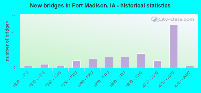
- New bridges - historical statistics
- 11920-1929
- 21930-1939
- 11940-1949
- 41950-1959
- 51960-1969
- 61970-1979
- 61980-1989
- 81990-1999
- 42000-2009
- 242010-2019
- 12020-2022
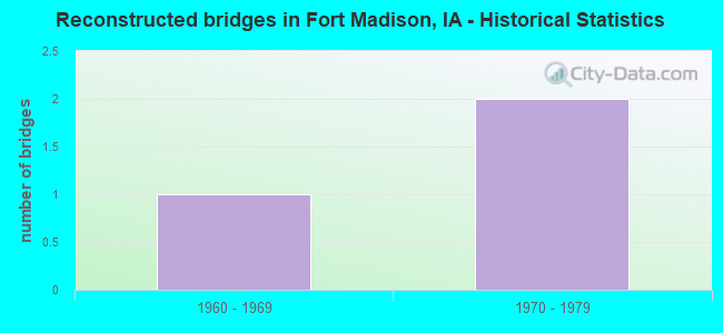
- Reconstructed bridges - Historical Statistics
- 11960-1969
- 21970-1979
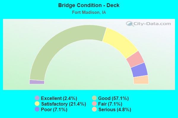
- Bridge Condition - Deck
- 2.4%Excellent
- 57.1%Good
- 21.4%Satisfactory
- 7.1%Fair
- 7.1%Poor
- 4.8%Serious
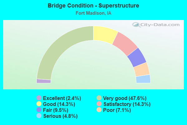
- Bridge Condition - Superstructure
- 2.4%Excellent
- 47.6%Very good
- 14.3%Good
- 14.3%Satisfactory
- 9.5%Fair
- 7.1%Poor
- 4.8%Serious
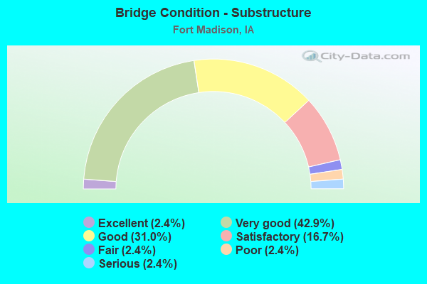
- Bridge Condition - Substructure
- 2.4%Excellent
- 42.9%Very good
- 31.0%Good
- 16.7%Satisfactory
- 2.4%Fair
- 2.4%Poor
- 2.4%Serious
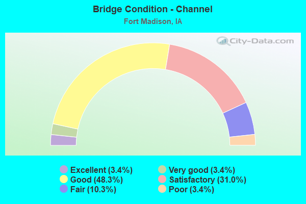
- Bridge Condition - Channel
- 3.4%Excellent
- 3.4%Very good
- 48.3%Good
- 31.0%Satisfactory
- 10.3%Fair
- 3.4%Poor
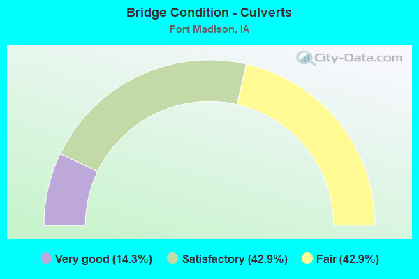
- Bridge Condition - Culverts
- 14.3%Very good
- 42.9%Satisfactory
- 42.9%Fair
Find on map >> Show street view
Structure Number: 60961, Location: 0.5 mi. N of Jct. Bus. 61 (Lat: 40.673367, Lng: -91.264439), Route carried "on" structure: County highway , Year Built: 2011, Status: Open, Structure Length: 8.35m (27.40ft), Average Daily Traffic: 520 (year 2018), Truck Traffic: 65%, Average Future Daily Traffic: 520 (year 2042), Design Load: HL 93, Features Intersected: US 61, Facility Carried by Structure: CO RD J50
Minimum Vertical Clearance: 30+ m (98+ ft), Kilometerpoint: 14.894, Lanes on structure: 2, Lanes under structure: 4, Owner: State Highway Agency, Approaching Roadway Width: 11.6m (38.1ft), Skew: 1 degrees, Material/Design: Prestressed concrete, Design/Construction: Stringer/Multi-beam, Number Of Spans In Main Unit: 4, Length of Maximum Span: 31.1m (102.0ft), Curb-To-Curb Width: 10.4m (34.1ft), Out-to-Out Width: 11.0m (36.1ft)
Condition: Deck: Good, Superstructure: Very good, Substructure: Very good, Operating Rating: 64.2 metric tons, Method Used To Determine Operating Rating: Load and Resistance Factor Rating (LRFR) rating reported by rating factor(RF) method using HL-93 loadings, Inventory Rating: 43.7 metric tons, Method Used To Determine Inventory Rating: Load and Resistance Factor Rating (LRFR) rating reported by rating factor(RF) method using HL-93 loadings, Structural Evaluation: Equal to present desirable criteria, Deck Geometry: Equal to present minimum criteria, Underclear: Better than present minimum criteria, Approach Roadway Alignment: Equal to present desirable criteria, Designated Inspection Frequency: Every 24 months, Inspection Date: January 2022, Deck Structure Type: Concrete Cast-file-Place, Wearing Surface/Protective System: Wearing Surface: Monolithic Concrete, Deck Protection: Epoxy Coated Reinforcing
Find on map >> Show street view
Structure Number: 609615, Location: At Jct of SR X-32 (Lat: 40.670225, Lng: -91.326906), Route carried "on" structure: County highway , Year Built: 2010, Status: Open, Structure Length: 7.99m (26.21ft), Average Daily Traffic: 2,470 (year 2018), Truck Traffic: 5%, Average Future Daily Traffic: 2,470 (year 2042), Design Load: HL 93, Features Intersected: US 61, Facility Carried by Structure: CO RD X32
Minimum Vertical Clearance: 30+ m (98+ ft), Kilometerpoint: 2.998, Lanes on structure: 2, Lanes under structure: 4, Owner: State Highway Agency, Approaching Roadway Width: 10.4m (34.1ft), Skew: 1 degrees, Material/Design: Prestressed concrete, Design/Construction: Stringer/Multi-beam, Number Of Spans In Main Unit: 3, Length of Maximum Span: 35.4m (116.1ft), Curb-To-Curb Width: 12.2m (40.0ft), Out-to-Out Width: 14.0m (45.9ft)
Condition: Deck: Good, Superstructure: Very good, Substructure: Very good, Operating Rating: 61.5 metric tons, Method Used To Determine Operating Rating: Load Factor (LF), Inventory Rating: 29.4 metric tons, Method Used To Determine Inventory Rating: Load Factor (LF), Structural Evaluation: Better than present minimum criteria, Deck Geometry: Equal to present minimum criteria, Underclear: Equal to present minimum criteria, Approach Roadway Alignment: Equal to present desirable criteria, Designated Inspection Frequency: Every 24 months, Inspection Date: January 2022, Deck Structure Type: Concrete Cast-file-Place, Wearing Surface/Protective System: Wearing Surface: Monolithic Concrete, Deck Protection: Epoxy Coated Reinforcing
Find on map >> Show street view
Structure Number: 609955, Location: 0.9 mi. S of Jct. Iowa #2 (Lat: 40.619222, Lng: -91.412744), Route carried "on" structure: US 61, Year Built: 2011, Status: Open, Structure Length: 4.82m (15.81ft), Average Daily Traffic: 3,850 (year 2020), Truck Traffic: 8%, Average Future Daily Traffic: 3,850 (year 2042), Design Load: HS 25 or greater, Features Intersected: COUNTY RD
Minimum Vertical Clearance: 30+ m (98+ ft), Kilometerpoint: 27.772, Lanes on structure: 2, Lanes under structure: 2, Base Highway Network: Yes, Owner: State Highway Agency, Approaching Roadway Width: 13.4m (44.0ft), Skew: 2 degrees, Material/Design: Prestressed concrete, Design/Construction: Stringer/Multi-beam, Number Of Spans In Main Unit: 1, Length of Maximum Span: 47.2m (154.9ft), Curb-To-Curb Width: 15.2m (49.9ft), Out-to-Out Width: 16.2m (53.1ft)
Condition: Deck: Good, Superstructure: Good, Substructure: Good, Operating Rating: 90.5 metric tons, Method Used To Determine Operating Rating: Load Factor (LF), Inventory Rating: 36.9 metric tons, Method Used To Determine Inventory Rating: Load Factor (LF), Structural Evaluation: Better than present minimum criteria, Deck Geometry: Superior to present desirable criteria, Underclear: Equal to present minimum criteria, Approach Roadway Alignment: Equal to present desirable criteria, Designated Inspection Frequency: Every 24 months, Inspection Date: January 2022, Deck Structure Type: Concrete Cast-file-Place, Wearing Surface/Protective System: Wearing Surface: Monolithic Concrete, Deck Protection: Epoxy Coated Reinforcing
Find on map >> Show street view
Structure Number: 60996, Location: 0.9 mi. S of Jct. Iowa #2 (Lat: 40.619706, Lng: -91.412681), Route carried "on" structure: US 61, Year Built: 2011, Status: Open, Structure Length: 4.82m (15.81ft), Average Daily Traffic: 3,850 (year 2020), Truck Traffic: 8%, Average Future Daily Traffic: 3,850 (year 2042), Design Load: HS 25 or greater, Features Intersected: COUNTY RD
Minimum Vertical Clearance: 30+ m (98+ ft), Kilometerpoint: 281.234, Lanes on structure: 2, Lanes under structure: 2, Owner: State Highway Agency, Approaching Roadway Width: 13.4m (44.0ft), Skew: 2 degrees, Material/Design: Prestressed concrete, Design/Construction: Stringer/Multi-beam, Number Of Spans In Main Unit: 1, Length of Maximum Span: 47.2m (154.9ft), Curb-To-Curb Width: 12.2m (40.0ft), Out-to-Out Width: 13.2m (43.3ft)
Condition: Deck: Good, Superstructure: Very good, Substructure: Very good, Operating Rating: 90.5 metric tons, Method Used To Determine Operating Rating: Load Factor (LF), Inventory Rating: 40.6 metric tons, Method Used To Determine Inventory Rating: Load Factor (LF), Structural Evaluation: Equal to present desirable criteria, Deck Geometry: Better than present minimum criteria, Underclear: Equal to present minimum criteria, Approach Roadway Alignment: Equal to present desirable criteria, Designated Inspection Frequency: Every 24 months, Inspection Date: January 2022, Deck Structure Type: Concrete Cast-file-Place, Wearing Surface/Protective System: Wearing Surface: Monolithic Concrete, Deck Protection: Epoxy Coated Reinforcing
Find on map >> Show street view
Structure Number: 609965, Location: 1.4 mi. S of Jct. SR J40 (Lat: 40.650058, Lng: -91.365700), Route carried "on" structure: US 61, Year Built: 2011, Status: Open, Structure Length: 4.96m (16.27ft), Average Daily Traffic: 2,215 (year 2020), Truck Traffic: 16%, Average Future Daily Traffic: 2,215 (year 2042), Design Load: HS 20, Features Intersected: CHALK RIDGE RD
Minimum Vertical Clearance: 30+ m (98+ ft), Kilometerpoint: 33.330, Lanes on structure: 2, Lanes under structure: 2, Base Highway Network: Yes, Owner: State Highway Agency, Approaching Roadway Width: 13.4m (44.0ft), Material/Design: Prestressed concrete, Design/Construction: Stringer/Multi-beam, Number Of Spans In Main Unit: 3, Length of Maximum Span: 24.8m (81.4ft), Curb-To-Curb Width: 12.8m (42.0ft), Out-to-Out Width: 13.8m (45.3ft)
Condition: Deck: Good, Superstructure: Very good, Substructure: Very good, Operating Rating: 79.5 metric tons, Method Used To Determine Operating Rating: Load Factor (LF), Inventory Rating: 37.3 metric tons, Method Used To Determine Inventory Rating: Load Factor (LF), Structural Evaluation: Equal to present desirable criteria, Deck Geometry: Equal to present desirable criteria, Underclear: Superior to present desirable criteria, Approach Roadway Alignment: Equal to present desirable criteria, Designated Inspection Frequency: Every 24 months, Inspection Date: January 2022, Deck Structure Type: Concrete Cast-file-Place, Wearing Surface/Protective System: Wearing Surface: Monolithic Concrete, Deck Protection: Epoxy Coated Reinforcing
Find on map >> Show street view
Structure Number: 60997, Location: 1.4 mi. S of Jct. SR J40 (Lat: 40.650531, Lng: -91.365506), Route carried "on" structure: US 61, Year Built: 2011, Status: Open, Structure Length: 4.96m (16.27ft), Average Daily Traffic: 2,215 (year 2020), Truck Traffic: 16%, Average Future Daily Traffic: 2,215 (year 2042), Design Load: HS 20, Features Intersected: CHALK RIDGE RD
Minimum Vertical Clearance: 30+ m (98+ ft), Kilometerpoint: 275.669, Lanes on structure: 2, Lanes under structure: 2, Owner: State Highway Agency, Approaching Roadway Width: 13.4m (44.0ft), Material/Design: Prestressed concrete, Design/Construction: Stringer/Multi-beam, Number Of Spans In Main Unit: 3, Length of Maximum Span: 24.8m (81.4ft), Curb-To-Curb Width: 12.8m (42.0ft), Out-to-Out Width: 13.8m (45.3ft)
Condition: Deck: Good, Superstructure: Very good, Substructure: Very good, Operating Rating: 79.5 metric tons, Method Used To Determine Operating Rating: Load Factor (LF), Inventory Rating: 37.3 metric tons, Method Used To Determine Inventory Rating: Load Factor (LF), Structural Evaluation: Equal to present desirable criteria, Deck Geometry: Equal to present desirable criteria, Underclear: Better than present minimum criteria, Approach Roadway Alignment: Equal to present desirable criteria, Designated Inspection Frequency: Every 24 months, Inspection Date: January 2022, Deck Structure Type: Concrete Cast-file-Place, Wearing Surface/Protective System: Wearing Surface: Monolithic Concrete, Deck Protection: Epoxy Coated Reinforcing
Find on map >> Show street view
Structure Number: 609975, Location: 1.4 mi. N of Jct. Iowa 2 (Lat: 40.638853, Lng: -91.380033), Route carried "on" structure: County highway , Year Built: 2011, Status: Open, Structure Length: 7.77m (25.49ft), Average Daily Traffic: 50 (year 2018), Average Future Daily Traffic: 50 (year 2042), Design Load: HL 93, Features Intersected: US 61, Facility Carried by Structure: 220TH ST
Minimum Vertical Clearance: 30+ m (98+ ft), Kilometerpoint: 5.546, Lanes on structure: 2, Lanes under structure: 4, Owner: State Highway Agency, Approaching Roadway Width: 9.1m (29.9ft), Material/Design: Prestressed concrete, Design/Construction: Stringer/Multi-beam, Number Of Spans In Main Unit: 2, Length of Maximum Span: 39.9m (130.9ft), Curb-To-Curb Width: 9.1m (29.9ft), Out-to-Out Width: 9.8m (32.2ft)
Condition: Deck: Good, Superstructure: Very good, Substructure: Very good, Operating Rating: 66.4 metric tons, Method Used To Determine Operating Rating: Assigned ratings based on Load and Resistance Factor Design (LRFD) reported by rating factor (RF) using HL93 loadings, Inventory Rating: 41.8 metric tons, Method Used To Determine Inventory Rating: Assigned ratings based on Load and Resistance Factor Design (LRFD) reported by rating factor (RF) using HL93 loadings, Structural Evaluation: Equal to present desirable criteria, Deck Geometry: Better than present minimum criteria, Underclear: Equal to present minimum criteria, Approach Roadway Alignment: Equal to present desirable criteria, Designated Inspection Frequency: Every 24 months, Inspection Date: January 2022, Deck Structure Type: Concrete Cast-file-Place, Wearing Surface/Protective System: Wearing Surface: Monolithic Concrete, Deck Protection: Epoxy Coated Reinforcing
Find on map >> Show street view
Structure Number: 60998, Location: 1.3 mi. N of Jct. SR X32 (Lat: 40.670250, Lng: -91.301358), Route carried "on" structure: County highway , Year Built: 2009, Status: Open, Structure Length: 7.16m (23.49ft), Average Daily Traffic: 440 (year 2018), Truck Traffic: 10%, Average Future Daily Traffic: 440 (year 2042), Design Load: HL 93, Features Intersected: US 61, Facility Carried by Structure: CO RD X 38
Minimum Vertical Clearance: 30+ m (98+ ft), Kilometerpoint: 2.668, Lanes on structure: 2, Lanes under structure: 4, Owner: State Highway Agency, Approaching Roadway Width: 10.4m (34.1ft), Material/Design: Prestressed concrete, Design/Construction: Stringer/Multi-beam, Number Of Spans In Main Unit: 2, Length of Maximum Span: 35.4m (116.1ft), Curb-To-Curb Width: 12.2m (40.0ft), Out-to-Out Width: 12.8m (42.0ft)
Condition: Deck: Good, Superstructure: Good, Substructure: Very good, Operating Rating: 84.1 metric tons, Method Used To Determine Operating Rating: Load Factor (LF), Inventory Rating: 30.3 metric tons, Method Used To Determine Inventory Rating: Load Factor (LF), Structural Evaluation: Better than present minimum criteria, Deck Geometry: Equal to present desirable criteria, Underclear: Equal to present minimum criteria, Approach Roadway Alignment: Equal to present desirable criteria, Designated Inspection Frequency: Every 24 months, Inspection Date: January 2022, Deck Structure Type: Concrete Cast-file-Place, Wearing Surface/Protective System: Wearing Surface: Monolithic Concrete, Deck Protection: Epoxy Coated Reinforcing
Find on map >> Show street view
Structure Number: 60957, Location: At the Jct. U.S. 61 (Lat: 40.626697, Lng: -91.399242), Route carried "under" structure: US 61, Year Built: 2011, Structure Length: 0. m, Average Daily Traffic: 2,470 (year 2020), Truck Traffic: 17%, Features Intersected: US 61, Facility Carried by Structure: IA 2
Minimum Vertical Clearance: 30+ m (98+ ft), Kilometerpoint: 29.235, Lanes on structure: 2, Lanes under structure: 4, Material/Design: Prestressed concrete, Design/Construction: Stringer/Multi-beam, Length of Maximum Span: 41.5m (136.2ft)
Find on map >> Show street view
Structure Number: 609575, Location: 1.0 mi. N of Jct. Iowa #2 (Lat: 40.633442, Lng: -91.381075), Route carried "under" structure: County highway , Year Built: 2011, Structure Length: 0. m, Average Daily Traffic: 615 (year 2018), Features Intersected: BLUFF RD, Facility Carried by Structure: US 61 SB
Minimum Vertical Clearance: 30+ m (98+ ft), Kilometerpoint: 1.888, Lanes on structure: 2, Lanes under structure: 2, Material/Design: Prestressed concrete, Design/Construction: Stringer/Multi-beam, Length of Maximum Span: 37.1m (121.7ft)
Find on map >> Show street view
Structure Number: 60958, Location: 1.0 mi. N of Jct. Iowa #2 (Lat: 40.632500, Lng: -91.381450), Route carried "under" structure: County highway , Year Built: 2011, Structure Length: 0. m, Average Daily Traffic: 615 (year 2018), Features Intersected: BLUFF RD, Facility Carried by Structure: US 61 NB
Minimum Vertical Clearance: 30+ m (98+ ft), Kilometerpoint: 1.933, Lanes on structure: 2, Lanes under structure: 2, Material/Design: Prestressed concrete, Design/Construction: Stringer/Multi-beam, Length of Maximum Span: 37.2m (122.0ft)
Find on map >> Show street view
Structure Number: 609585, Location: At the Jct. SR J-40 (Lat: 40.669200, Lng: -91.358225), Route carried "under" structure: US 61, Year Built: 2011, Structure Length: 0. m, Average Daily Traffic: 4,090 (year 2020), Truck Traffic: 17%, Features Intersected: US 61, Facility Carried by Structure: CO RD J40
Minimum Vertical Clearance: 30+ m (98+ ft), Kilometerpoint: 35.608, Lanes on structure: 2, Lanes under structure: 4, Material/Design: Prestressed concrete, Design/Construction: Stringer/Multi-beam, Length of Maximum Span: 41.5m (136.2ft)
Find on map >> Show street view
Structure Number: 609605, Location: At the Jct. SR J50 (Lat: 40.670231, Lng: -91.272136), Route carried "under" structure: US 61, Year Built: 2011, Structure Length: 0. m, Average Daily Traffic: 5,400 (year 2020), Truck Traffic: 12%, Features Intersected: US 61
Minimum Vertical Clearance: 30+ m (98+ ft), Kilometerpoint: 42.894, Lanes on structure: 2, Lanes under structure: 4, Material/Design: Prestressed concrete, Design/Construction: Stringer/Multi-beam, Length of Maximum Span: 38.4m (126.0ft)
Find on map >> Show street view
Structure Number: 60961, Location: 0.5 mi. N of Jct. Bus. 61 (Lat: 40.673367, Lng: -91.264439), Route carried "under" structure: US 61, Year Built: 2011, Structure Length: 0. m, Average Daily Traffic: 8,500 (year 2020), Truck Traffic: 11%, Features Intersected: US 61, Facility Carried by Structure: CO RD J50
Minimum Vertical Clearance: 30+ m (98+ ft), Kilometerpoint: 43.678, Lanes on structure: 2, Lanes under structure: 4, Material/Design: Prestressed concrete, Design/Construction: Stringer/Multi-beam, Length of Maximum Span: 31.1m (102.0ft)
Find on map >> Show street view
Structure Number: 609615, Location: At Jct of SR X-32 (Lat: 40.670225, Lng: -91.326906), Route carried "under" structure: US 61, Year Built: 2010, Structure Length: 0. m, Average Daily Traffic: 4,720 (year 2020), Truck Traffic: 14%, Features Intersected: US 61, Facility Carried by Structure: CO RD X32
Minimum Vertical Clearance: 30+ m (98+ ft), Kilometerpoint: 38.265, Lanes on structure: 2, Lanes under structure: 4, Material/Design: Prestressed concrete, Design/Construction: Stringer/Multi-beam, Length of Maximum Span: 35.4m (116.1ft)
Find on map >> Show street view
Structure Number: 609955, Location: 0.9 mi. S of Jct. Iowa #2 (Lat: 40.619222, Lng: -91.412744), Route carried "under" structure: County highway , Year Built: 2011, Structure Length: 0. m, Average Daily Traffic: 75 (year 2018), Features Intersected: COUNTY RD, Facility Carried by Structure: US 61 NB
Minimum Vertical Clearance: 30+ m (98+ ft), Kilometerpoint: 0.219, Lanes on structure: 2, Lanes under structure: 2, Material/Design: Prestressed concrete, Design/Construction: Stringer/Multi-beam, Length of Maximum Span: 47.2m (154.9ft)
Find on map >> Show street view
Structure Number: 60996, Location: 0.9 mi. S of Jct. Iowa #2 (Lat: 40.619706, Lng: -91.412681), Route carried "under" structure: County highway , Year Built: 2011, Structure Length: 0. m, Average Daily Traffic: 75 (year 2018), Features Intersected: COUNTY RD, Facility Carried by Structure: US 61 SB
Minimum Vertical Clearance: 30+ m (98+ ft), Kilometerpoint: 0.248, Lanes on structure: 2, Lanes under structure: 2, Material/Design: Prestressed concrete, Design/Construction: Stringer/Multi-beam, Length of Maximum Span: 47.2m (154.9ft)
Find on map >> Show street view
Structure Number: 609965, Location: 1.4 mi. S of Jct. SR J40 (Lat: 40.650058, Lng: -91.365700), Route carried "under" structure: County highway , Year Built: 2011, Structure Length: 0. m, Average Daily Traffic: 185 (year 2018), Features Intersected: CHALK RIDGE RD, Facility Carried by Structure: US 61 NB
Minimum Vertical Clearance: 30+ m (98+ ft), Kilometerpoint: 5.985, Lanes on structure: 2, Lanes under structure: 2, Material/Design: Prestressed concrete, Design/Construction: Stringer/Multi-beam, Length of Maximum Span: 24.8m (81.4ft)
Find on map >> Show street view
Structure Number: 60997, Location: 1.4 mi. S of Jct. SR J40 (Lat: 40.650531, Lng: -91.365506), Route carried "under" structure: County highway , Year Built: 2011, Structure Length: 0. m, Average Daily Traffic: 185 (year 2018), Features Intersected: CHALK RIDGE RD, Facility Carried by Structure: US 61 SB
Minimum Vertical Clearance: 30+ m (98+ ft), Kilometerpoint: 5.958, Lanes on structure: 2, Lanes under structure: 2, Material/Design: Prestressed concrete, Design/Construction: Stringer/Multi-beam, Length of Maximum Span: 24.8m (81.4ft)
Find on map >> Show street view
Structure Number: 609975, Location: 1.4 mi. N of Jct. Iowa 2 (Lat: 40.638853, Lng: -91.380033), Route carried "under" structure: US 61, Year Built: 2011, Structure Length: 0. m, Average Daily Traffic: 4,430 (year 2020), Truck Traffic: 16%, Features Intersected: US 61, Facility Carried by Structure: 220TH ST
Minimum Vertical Clearance: 30+ m (98+ ft), Kilometerpoint: 31.601, Lanes on structure: 2, Lanes under structure: 4, Material/Design: Prestressed concrete, Design/Construction: Stringer/Multi-beam, Length of Maximum Span: 39.9m (130.9ft)
Find on map >> Show street view
Structure Number: 60998, Location: 1.3 mi. N of Jct. SR X32 (Lat: 40.670250, Lng: -91.301358), Route carried "under" structure: US 61, Year Built: 2009, Structure Length: 0. m, Average Daily Traffic: 5,900 (year 2020), Truck Traffic: 13%, Features Intersected: US 61, Facility Carried by Structure: CO RD X 38
Minimum Vertical Clearance: 30+ m (98+ ft), Kilometerpoint: 40.430, Lanes on structure: 2, Lanes under structure: 4, Material/Design: Prestressed concrete, Design/Construction: Stringer/Multi-beam, Length of Maximum Span: 35.4m (116.1ft)