Bridge Statistics for Fort Smith, Arkansas (AR)
Condition, Traffic, Stress, Structural Evaluation, Project Costs
- National Bridge Inventory (NBI) Statistics
- 170Number of bridges
- 2,051ft / 625mTotal length
- $6,733,000Total costs
- 1,847,075Total average daily traffic
- 71,421Total average daily truck traffic
- National Bridge Inventory (NBI) Registered Bridges for Fort Smith
- No street view available for this location
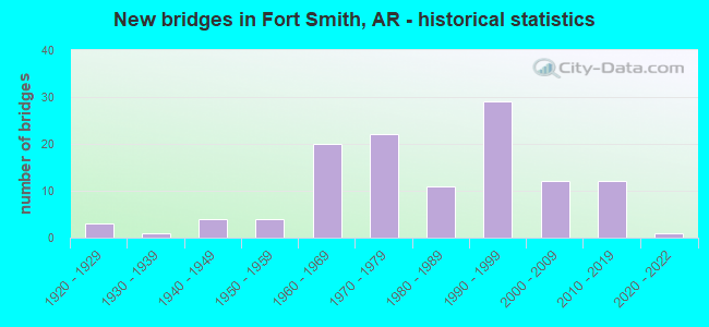
- New bridges - historical statistics
- 31920-1929
- 11930-1939
- 41940-1949
- 41950-1959
- 201960-1969
- 221970-1979
- 111980-1989
- 291990-1999
- 122000-2009
- 122010-2019
- 12020-2022
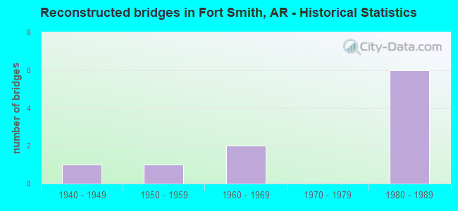
- Reconstructed bridges - Historical Statistics
- 11940-1949
- 11950-1959
- 21960-1969
- 01970-1979
- 61980-1989
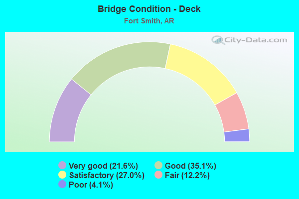
- Bridge Condition - Deck
- 21.6%Very good
- 35.1%Good
- 27.0%Satisfactory
- 12.2%Fair
- 4.1%Poor
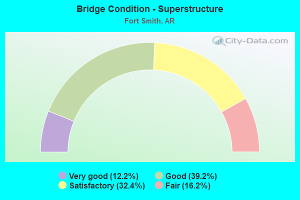
- Bridge Condition - Superstructure
- 12.2%Very good
- 39.2%Good
- 32.4%Satisfactory
- 16.2%Fair
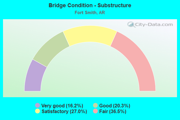
- Bridge Condition - Substructure
- 16.2%Very good
- 20.3%Good
- 27.0%Satisfactory
- 36.5%Fair
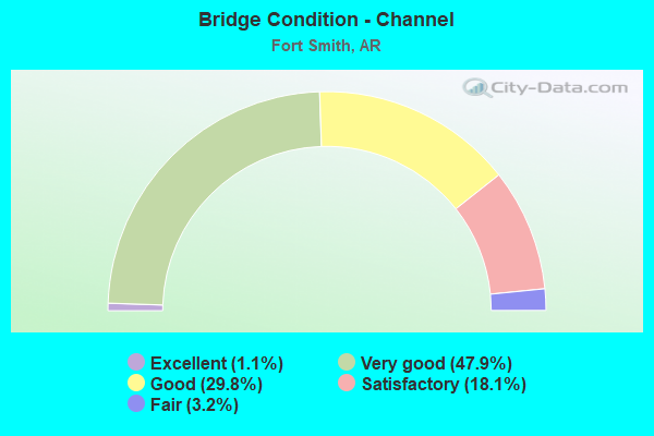
- Bridge Condition - Channel
- 1.1%Excellent
- 47.9%Very good
- 29.8%Good
- 18.1%Satisfactory
- 3.2%Fair
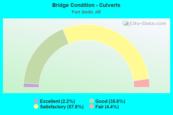
- Bridge Condition - Culverts
- 2.2%Excellent
- 35.6%Good
- 57.8%Satisfactory
- 4.4%Fair
Find on map >> Show street view
Structure Number: 5176, Location: 0.3 MI NE SH 59 (Lat: 35.426711, Lng: -94.361581), Route carried "under" structure: City street 64450, Structure Length: 0. m, Average Daily Traffic: 228 (year 1983), Truck Traffic: 1%, Features Intersected: Cty Sts, RR, ARK RIVER, Facility Carried by Structure: US 64-District 4
Minimum Vertical Clearance: 6.64m (21.78ft), Kilometerpoint: 0.370, Length of Maximum Span: 0.0m
Find on map >> Show street view
Structure Number: 5176, Location: 0.3 MI NE SH 59 (Lat: 35.426711, Lng: -94.361581), Route carried "under" structure: City street 46743, Structure Length: 0. m, Average Daily Traffic: 25 (year 1983), Truck Traffic: 1%, Features Intersected: Cty Sts, RR, ARK RIVER, Facility Carried by Structure: US 64-District 4
Minimum Vertical Clearance: 7.07m (23.20ft), Kilometerpoint: 0.016, Length of Maximum Span: 0.0m
Find on map >> Show street view
Structure Number: 5176, Location: 0.3 MI NE SH 59 (Lat: 35.426711, Lng: -94.361581), Route carried "under" structure: Other road 46743, Structure Length: 0. m, Average Daily Traffic: 1 (year 1992), Truck Traffic: 1%, Features Intersected: Cty Sts, RR, ARK RIVER, Facility Carried by Structure: US 64-District 4
Minimum Vertical Clearance: 6.97m (22.87ft), Kilometerpoint: 0.002, Length of Maximum Span: 0.0m
Find on map >> Show street view
Structure Number: 5176, Location: 0.3 MI NE SH 59 (Lat: 35.426711, Lng: -94.361581), Route carried "under" structure: City street 64470, Structure Length: 0. m, Average Daily Traffic: 89 (year 1992), Truck Traffic: 1%, Features Intersected: Cty Sts, RR, ARK RIVER, Facility Carried by Structure: US 64-District 4
Minimum Vertical Clearance: 4.84m (15.88ft), Kilometerpoint: 0.002, Length of Maximum Span: 0.0m
Find on map >> Show street view
Structure Number: 5275, Location: AT OKLAHOMA & ARK ST LN (Lat: 35.395350, Lng: -94.437289), Route carried "under" structure: Other road 4250, Structure Length: 0. m, Features Intersected: ARK RVR & ARKMO/BN RRS, Facility Carried by Structure: US 64 - District 4
Minimum Vertical Clearance: 7.04m (23.10ft), Kilometerpoint: 0.805, Length of Maximum Span: 0.0m
Find on map >> Show street view
Structure Number: 5275, Location: AT OKLAHOMA & ARK ST LN (Lat: 35.395350, Lng: -94.437289), Route carried "under" structure: City street 4250, Structure Length: 0. m, Average Daily Traffic: 100 (year 1987), Truck Traffic: 1%, Features Intersected: ARK RVR & ARKMO/BN RRS, Facility Carried by Structure: US 64 - District 4
Minimum Vertical Clearance: 6.79m (22.28ft), Kilometerpoint: 0.805, Length of Maximum Span: 0.0m
Find on map >> Show street view
Structure Number: 5654, Location: 0.53 MI W JCT US 71 (Lat: 35.306539, Lng: -94.405250), Route carried "under" structure: Interstate 540, Structure Length: 0. m, Average Daily Traffic: 15,500 (year 2013), Truck Traffic: 1%, Features Intersected: I 540-SEC 1, Facility Carried by Structure: S 28TH STREET
Minimum Vertical Clearance: 5.05m (16.57ft), Kilometerpoint: 3.315, Length of Maximum Span: 0.0m
Find on map >> Show street view
Structure Number: 5654, Location: 0.53 MI W JCT US 71 (Lat: 35.306539, Lng: -94.405250), Route carried "under" structure: Interstate 540, Structure Length: 0. m, Average Daily Traffic: 15,500 (year 2013), Truck Traffic: 1%, Features Intersected: I 540-SEC 1, Facility Carried by Structure: S 28TH STREET
Minimum Vertical Clearance: 4.96m (16.27ft), Kilometerpoint: 3.315, Length of Maximum Span: 0.0m
Find on map >> Show street view
Structure Number: 7079, Location: 0.53 Mi NJct US 71 (Lat: 35.263111, Lng: -94.353550), Route carried "under" structure: State highway 549, Structure Length: 0. m, Average Daily Traffic: 12,000 (year 2013), Truck Traffic: 21%, Features Intersected: SH 549 South bound lanes, Facility Carried by Structure: Howard Hill - Seb
Minimum Vertical Clearance: 9.90m (32.48ft), Kilometerpoint: 0.853, Length of Maximum Span: 0.0m
Find on map >> Show street view
Structure Number: 7079, Location: 0.53 Mi NJct US 71 (Lat: 35.263111, Lng: -94.353550), Route carried "under" structure: State highway 549, Structure Length: 0. m, Average Daily Traffic: 12,000 (year 2013), Truck Traffic: 21%, Features Intersected: SH 549 North Bound lanes, Facility Carried by Structure: Howard Hill - Seb
Minimum Vertical Clearance: 10.86m (35.63ft), Kilometerpoint: 0.853, Length of Maximum Span: 0.0m
Find on map >> Show street view
Structure Number: 708, Location: 1.51 mi N Jct. US 71 (Lat: 35.275731, Lng: -94.346489), Route carried "under" structure: State highway 549, Structure Length: 0. m, Average Daily Traffic: 21,213 (year 2008), Truck Traffic: 21%, Features Intersected: SH 549, Facility Carried by Structure: County Road 90
Minimum Vertical Clearance: 5.18m (16.99ft), Kilometerpoint: 2.430, Length of Maximum Span: 0.0m
Find on map >> Show street view
Structure Number: 708, Location: 1.51 mi N Jct. US 71 (Lat: 35.275731, Lng: -94.346489), Route carried "under" structure: State highway 549, Structure Length: 0. m, Average Daily Traffic: 21,213 (year 2008), Truck Traffic: 21%, Features Intersected: SH 549, Facility Carried by Structure: County Road 90
Minimum Vertical Clearance: 5.76m (18.90ft), Kilometerpoint: 2.430, Length of Maximum Span: 0.0m
Find on map >> Show street view
Structure Number: 709, Location: 4.97 MI S OF I 40-11 (Lat: 35.403469, Lng: -94.366689), Route carried "under" structure: Interstate 540, Structure Length: 0. m, Average Daily Traffic: 26,500 (year 2013), Truck Traffic: 1%, Features Intersected: I 540-1, Facility Carried by Structure: Kelly Hwy
Minimum Vertical Clearance: 5.15m (16.90ft), Kilometerpoint: 15.784, Length of Maximum Span: 0.0m
Find on map >> Show street view
Structure Number: 7176, Location: 3.74 Mi. N. of US 71 (Lat: 35.336911, Lng: -94.390939), Route carried "under" structure: Interstate 540, Structure Length: 0. m, Average Daily Traffic: 21,000 (year 2013), Truck Traffic: 1%, Features Intersected: I-540 - Sec. 1, Facility Carried by Structure: S.H. 45 - Sec. 2
Minimum Vertical Clearance: 5.23m (17.16ft), Kilometerpoint: 7.113, Length of Maximum Span: 0.0m
Find on map >> Show street view
Structure Number: 7176, Location: 3.74 Mi. N. of US 71 (Lat: 35.336911, Lng: -94.390939), Route carried "under" structure: Interstate 540, Structure Length: 0. m, Average Daily Traffic: 21,000 (year 2013), Truck Traffic: 1%, Features Intersected: I-540 - Sec. 1, Facility Carried by Structure: S.H. 45 - Sec. 2
Minimum Vertical Clearance: 5.41m (17.75ft), Kilometerpoint: 7.113, Length of Maximum Span: 0.0m
Find on map >> Show street view
Structure Number: 19471, Location: 0.40MI W OF HWY 71TOWSON (Lat: 35.359722, Lng: -94.428333), Route carried "under" structure: City street 63920, Structure Length: 0. m, Average Daily Traffic: 3,800 (year 1983), Truck Traffic: 1%, Features Intersected: West "Y" Street, Facility Carried by Structure: SL SW RR
Minimum Vertical Clearance: 4.11m (13.48ft), Kilometerpoint: 0.644, Length of Maximum Span: 0.0m
Find on map >> Show street view
Structure Number: A3604, Location: 1 MI N JCT SH 22 (Lat: 35.374031, Lng: -94.365139), Route carried "under" structure: City street 21120, Structure Length: 0. m, Average Daily Traffic: 2,973 (year 1983), Truck Traffic: 1%, Features Intersected: Free Ferry St., Facility Carried by Structure: I 540, SB LNS
Minimum Vertical Clearance: 4.72m (15.49ft), Kilometerpoint: 3.603, Length of Maximum Span: 0.0m
Find on map >> Show street view
Structure Number: A5096, Location: 0.22 MI S JCT SH 22 (Lat: 35.354469, Lng: -94.365211), Route carried "under" structure: City street 6160, Structure Length: 0. m, Average Daily Traffic: 1,879 (year 1983), Truck Traffic: 1%, Features Intersected: Boston Street, Facility Carried by Structure: I 540-SEC 1, SB LN
Minimum Vertical Clearance: 7.59m (24.90ft), Kilometerpoint: 5.422, Length of Maximum Span: 0.0m
Find on map >> Show street view
Structure Number: A5098, Location: 0.30 MI E OF SH 45 (Lat: 35.338569, Lng: -94.386431), Route carried "under" structure: City street 45140, Structure Length: 0. m, Average Daily Traffic: 4,219 (year 1983), Truck Traffic: 1%, Features Intersected: Phoenix Street, Facility Carried by Structure: I-540 Southbound
Minimum Vertical Clearance: 5.05m (16.57ft), Kilometerpoint: 3.380, Length of Maximum Span: 0.0m
Find on map >> Show street view
Structure Number: A5101, Location: 0.73 SO JCT SH 45 (Lat: 35.327181, Lng: -94.394989), Route carried "under" structure: State highway 255, Structure Length: 0. m, Average Daily Traffic: 17,000 (year 2014), Truck Traffic: 1%, Features Intersected: SH 255-SEC 3, Facility Carried by Structure: I 540-SEC 1, SB LN
Minimum Vertical Clearance: 5.57m (18.27ft), Kilometerpoint: 8.496, Length of Maximum Span: 0.0m
Find on map >> Show street view
Structure Number: A5102, Location: JCT I540 & US 71 (Lat: 35.312303, Lng: -94.399231), Route carried "under" structure: US 71, Structure Length: 0. m, Average Daily Traffic: 13,500 (year 2014), Truck Traffic: 1%, Features Intersected: US 71-SEC 14, RR, Facility Carried by Structure: I 540-SEC 1, SB LN
Minimum Vertical Clearance: 6.24m (20.47ft), Kilometerpoint: 15.784, Length of Maximum Span: 0.0m
Find on map >> Show street view
Structure Number: A5102, Location: JCT I540 & US 71 (Lat: 35.312303, Lng: -94.399231), Route carried "under" structure: US 71, Structure Length: 0. m, Average Daily Traffic: 13,500 (year 2014), Truck Traffic: 1%, Features Intersected: US 71-SEC 14, RR, Facility Carried by Structure: I 540-SEC 1, SB LN
Minimum Vertical Clearance: 6.42m (21.06ft), Kilometerpoint: 15.784, Length of Maximum Span: 0.0m
Find on map >> Show street view
Structure Number: A5103, Location: JCT 253, 271 & 540 (Lat: 35.293361, Lng: -94.423650), Route carried "under" structure: US 271, Structure Length: 0. m, Average Daily Traffic: 16,000 (year 2013), Truck Traffic: 1%, Features Intersected: US 271-SEC 1, Facility Carried by Structure: I 540-SEC 1, WB LN
Minimum Vertical Clearance: 4.74m (15.55ft), Kilometerpoint: 4.102, Length of Maximum Span: 0.0m
Find on map >> Show street view
Structure Number: A5629, Location: 0.95 MI W JCT I540 & 71 (Lat: 35.302839, Lng: -94.410450), Route carried "under" structure: City street 29350, Structure Length: 0. m, Average Daily Traffic: 1,534 (year 1983), Truck Traffic: 1%, Features Intersected: Jenny Lind Street, Facility Carried by Structure: I 540-SEC 1, WB LN
Minimum Vertical Clearance: 4.93m (16.17ft), Kilometerpoint: 7.820, Length of Maximum Span: 0.0m
Find on map >> Show street view
Structure Number: A6877, Location: 6.73 Mi NE OK State Line (Lat: 35.359381, Lng: -94.365131), Route carried "under" structure: State highway 22, Structure Length: 0. m, Average Daily Traffic: 19,500 (year 2014), Truck Traffic: 1%, Features Intersected: SH 22 - Sec 1, WB Lanes, Facility Carried by Structure: I-540 SB Lanes-Seb
Minimum Vertical Clearance: 5.30m (17.39ft), Kilometerpoint: 5.906, Length of Maximum Span: 0.0m
Find on map >> Show street view
Structure Number: A6877, Location: 6.73 Mi NE OK State Line (Lat: 35.359381, Lng: -94.365131), Route carried "under" structure: State highway 22, Structure Length: 0. m, Average Daily Traffic: 19,500 (year 2014), Truck Traffic: 1%, Features Intersected: SH 22 - Sec 1, EB Lanes, Facility Carried by Structure: I-540 SB Lanes-Seb
Minimum Vertical Clearance: 5.48m (17.98ft), Kilometerpoint: 5.906, Length of Maximum Span: 0.0m
Find on map >> Show street view
Structure Number: A6878, Location: 6.24 Mi So Jct I40-11 (Lat: 35.384839, Lng: -94.364339), Route carried "under" structure: City street 23200, Structure Length: 0. m, Average Daily Traffic: 1,481 (year 1983), Truck Traffic: 1%, Features Intersected: Grand Avenue, Facility Carried by Structure: I-540 SB Lanes
Minimum Vertical Clearance: 5.12m (16.80ft), Kilometerpoint: 5.341, Length of Maximum Span: 0.0m
Find on map >> Show street view
Structure Number: B3604, Location: 1 MI NO JCT SH 22 (Lat: 35.374031, Lng: -94.364853), Route carried "under" structure: City street 21120, Structure Length: 0. m, Average Daily Traffic: 2,973 (year 1983), Truck Traffic: 1%, Features Intersected: Free Ferry St., Facility Carried by Structure: I 540, NB LNS
Minimum Vertical Clearance: 4.74m (15.55ft), Kilometerpoint: 3.619, Length of Maximum Span: 0.0m
Find on map >> Show street view
Structure Number: B5096, Location: 2.01 MI NO OF SH 45 (Lat: 35.354481, Lng: -94.365069), Route carried "under" structure: City street 6160, Structure Length: 0. m, Average Daily Traffic: 1,879 (year 1983), Truck Traffic: 1%, Features Intersected: BOSTON ST., Facility Carried by Structure: I 540-SEC 1, NB LN
Minimum Vertical Clearance: 7.74m (25.39ft), Kilometerpoint: 5.438, Length of Maximum Span: 0.0m
Find on map >> Show street view
Structure Number: B5098, Location: 0.3 MI NO OF SH 45 (Lat: 35.338489, Lng: -94.386311), Route carried "under" structure: City street 45140, Structure Length: 0. m, Average Daily Traffic: 4,219 (year 1983), Truck Traffic: 1%, Features Intersected: Phoenix Street, Facility Carried by Structure: I-540 Northbound
Minimum Vertical Clearance: 5.33m (17.49ft), Kilometerpoint: 3.396, Length of Maximum Span: 0.0m
Find on map >> Show street view
Structure Number: B5101, Location: 0.73 MI SO OF SH 45 (Lat: 35.327178, Lng: -94.394853), Route carried "under" structure: State highway 255, Structure Length: 0. m, Average Daily Traffic: 17,000 (year 2014), Truck Traffic: 1%, Features Intersected: SH 255-SEC 3, Facility Carried by Structure: I 540-SEC 1, NB LN
Minimum Vertical Clearance: 5.23m (17.16ft), Kilometerpoint: 8.512, Length of Maximum Span: 0.0m
Find on map >> Show street view
Structure Number: B5102, Location: JCT I540 & US 71 (Lat: 35.312181, Lng: -94.399161), Route carried "under" structure: US 71, Structure Length: 0. m, Average Daily Traffic: 13,500 (year 2014), Truck Traffic: 1%, Features Intersected: US 71-SEC 14, RR, Facility Carried by Structure: I 540-SEC 1, EB LN
Minimum Vertical Clearance: 6.29m (20.64ft), Kilometerpoint: 15.801, Length of Maximum Span: 0.0m
Find on map >> Show street view
Structure Number: B5102, Location: JCT I540 & US 71 (Lat: 35.312181, Lng: -94.399161), Route carried "under" structure: US 71, Structure Length: 0. m, Average Daily Traffic: 13,500 (year 2014), Truck Traffic: 1%, Features Intersected: US 71-SEC 14, RR, Facility Carried by Structure: I 540-SEC 1, EB LN
Minimum Vertical Clearance: 6.50m (21.33ft), Kilometerpoint: 15.801, Length of Maximum Span: 0.0m
Find on map >> Show street view
Structure Number: B5103, Location: 0.65 Mi E of Ok St Line (Lat: 35.293231, Lng: -94.423650), Route carried "under" structure: US 271, Structure Length: 0. m, Average Daily Traffic: 16,000 (year 2014), Truck Traffic: 1%, Features Intersected: US 271-SEC 1, Facility Carried by Structure: I 540-SEC 1, EB LN
Minimum Vertical Clearance: 4.99m (16.37ft), Kilometerpoint: 4.088, Length of Maximum Span: 0.0m
Find on map >> Show street view
Structure Number: B5629, Location: 0.95 MI W JCT US 71 & 540 (Lat: 35.302750, Lng: -94.410339), Route carried "under" structure: City street 29350, Structure Length: 0. m, Average Daily Traffic: 1,534 (year 1983), Truck Traffic: 1%, Features Intersected: Jenny Lind Street, Facility Carried by Structure: I-540 NB-Sebastian
Minimum Vertical Clearance: 4.62m (15.16ft), Kilometerpoint: 7.820, Length of Maximum Span: 0.0m
Find on map >> Show street view
Structure Number: B6877, Location: 6.73 Mi NE OK state line (Lat: 35.359250, Lng: -94.364850), Route carried "under" structure: State highway 22, Structure Length: 0. m, Average Daily Traffic: 19,500 (year 2014), Truck Traffic: 1%, Features Intersected: SH 22 - Sec 1, Facility Carried by Structure: I-540 NB-Seb. Co.
Minimum Vertical Clearance: 5.02m (16.47ft), Kilometerpoint: 5.955, Length of Maximum Span: 0.0m
Find on map >> Show street view
Structure Number: B6877, Location: 6.73 Mi NE OK state line (Lat: 35.359250, Lng: -94.364850), Route carried "under" structure: State highway 22, Structure Length: 0. m, Average Daily Traffic: 19,500 (year 2014), Truck Traffic: 1%, Features Intersected: SH 22 - Sec 1, Facility Carried by Structure: I-540 NB-Seb. Co.
Minimum Vertical Clearance: 4.26m (13.98ft), Kilometerpoint: 5.955, Length of Maximum Span: 0.0m
Find on map >> Show street view
Structure Number: B6878, Location: 1.77 MI N SH 22 (Lat: 35.384831, Lng: -94.364061), Route carried "under" structure: City street 23200, Structure Length: 0. m, Average Daily Traffic: 1,481 (year 1983), Truck Traffic: 1%, Features Intersected: Grand Avenue, Facility Carried by Structure: I-540 NB Lanes
Minimum Vertical Clearance: 5.66m (18.57ft), Kilometerpoint: 5.358, Length of Maximum Span: 0.0m
Find on map >> Show street view
Structure Number: B6878, Location: 1.77 MI N SH 22 (Lat: 35.384831, Lng: -94.364061), Route carried "under" structure: City street 23200, Structure Length: 0. m, Average Daily Traffic: 2,414 (year 1990), Truck Traffic: 1%, Features Intersected: Grand Avenue, Facility Carried by Structure: I-540 NB Lanes
Minimum Vertical Clearance: 5.69m (18.67ft), Kilometerpoint: 0.536, Length of Maximum Span: 0.0m