Bridge Statistics for Fort Stockton, Texas (TX)
Condition, Traffic, Stress, Structural Evaluation, Project Costs
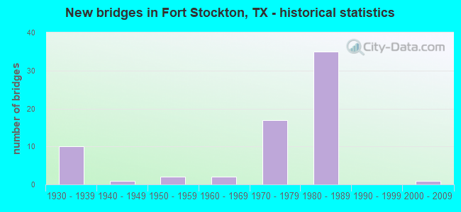
- New bridges - historical statistics
- 101930-1939
- 11940-1949
- 21950-1959
- 21960-1969
- 171970-1979
- 351980-1989
- 12000-2009
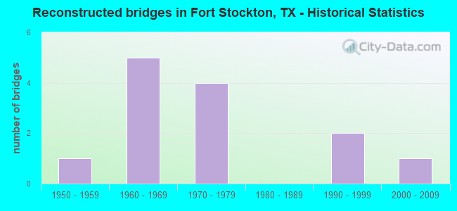
- Reconstructed bridges - Historical Statistics
- 11950-1959
- 51960-1969
- 41970-1979
- 01980-1989
- 21990-1999
- 12000-2009
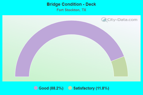
- Bridge Condition - Deck
- 88.2%Good
- 11.8%Satisfactory
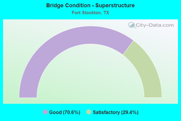
- Bridge Condition - Superstructure
- 70.6%Good
- 29.4%Satisfactory
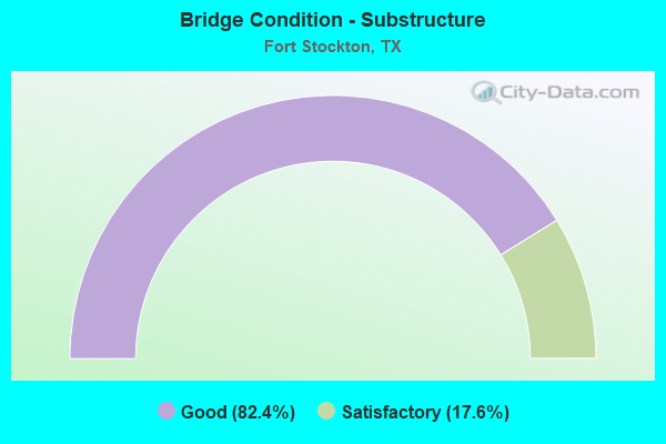
- Bridge Condition - Substructure
- 82.4%Good
- 17.6%Satisfactory
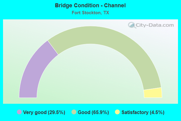
- Bridge Condition - Channel
- 29.5%Very good
- 65.9%Good
- 4.5%Satisfactory
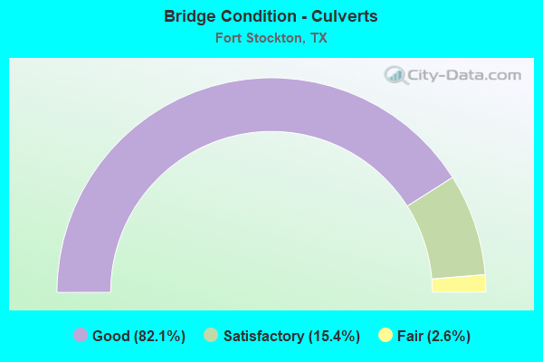
- Bridge Condition - Culverts
- 82.1%Good
- 15.4%Satisfactory
- 2.6%Fair
Find on map >> Show street view
Structure Number: 6186004410818, Location: 2.2 Mi W of SH 18 (Lat: 30.896333, Lng: -102.918747), Route carried "on" structure: Interstate 10, Year Built: 1983, Status: Open, Structure Length: 5.64m (18.50ft), Average Daily Traffic: 3,001 (year 2019), Truck Traffic: 33%, Average Future Daily Traffic: 4,170 (year 2033), Design Load: HS 20, Features Intersected: BI 10
Minimum Vertical Clearance: 30+ m (98+ ft), Kilometerpoint: 7.868, Lanes on structure: 2, Lanes under structure: 2, Owner: State Highway Agency, Approaching Roadway Width: 11.6m (38.1ft), Material/Design: Prestressed concrete, Design/Construction: Stringer/Multi-beam, Number Of Spans In Main Unit: 1, Number Of Approach Spans: 2, Length of Maximum Span: 25.6m (84.0ft), Curb-To-Curb Width: 11.3m (37.1ft), Out-to-Out Width: 12.2m (40.0ft)
Condition: Deck: Good, Superstructure: Good, Substructure: Good, Operating Rating: 54.4 metric tons, Method Used To Determine Operating Rating: Assigned rating based on Load Factor Design (LFD) reported in metric tons, Inventory Rating: 32.7 metric tons, Method Used To Determine Inventory Rating: Assigned rating based on Load Factor Design (LFD) reported in metric tons, Structural Evaluation: Better than present minimum criteria, Deck Geometry: Somewhat better than minimum adequacy, Underclear: Better than present minimum criteria, Approach Roadway Alignment: Equal to present desirable criteria, Designated Inspection Frequency: Every 24 months, Inspection Date: September 2021, Deck Structure Type: Concrete Cast-file-Place, Wearing Surface/Protective System: Wearing Surface: Bituminous
Find on map >> Show street view
Structure Number: 61860044108181, Location: 2.2 Mi W of SH 18 (Lat: 30.896808, Lng: -102.918458), Route carried "on" structure: Interstate 10, Year Built: 1983, Status: Open, Structure Length: 5.64m (18.50ft), Average Daily Traffic: 1,859 (year 2019), Truck Traffic: 33%, Average Future Daily Traffic: 4,170 (year 2033), Design Load: HS 20, Features Intersected: BI 10
Minimum Vertical Clearance: 30+ m (98+ ft), Kilometerpoint: 7.868, Lanes on structure: 2, Lanes under structure: 2, Owner: State Highway Agency, Approaching Roadway Width: 11.6m (38.1ft), Material/Design: Prestressed concrete, Design/Construction: Stringer/Multi-beam, Number Of Spans In Main Unit: 1, Number Of Approach Spans: 2, Length of Maximum Span: 25.6m (84.0ft), Curb-To-Curb Width: 11.3m (37.1ft), Out-to-Out Width: 12.2m (40.0ft)
Condition: Deck: Good, Superstructure: Good, Substructure: Good, Operating Rating: 54.4 metric tons, Method Used To Determine Operating Rating: Assigned rating based on Load Factor Design (LFD) reported in metric tons, Inventory Rating: 32.7 metric tons, Method Used To Determine Inventory Rating: Assigned rating based on Load Factor Design (LFD) reported in metric tons, Structural Evaluation: Better than present minimum criteria, Deck Geometry: Somewhat better than minimum adequacy, Underclear: Better than present minimum criteria, Approach Roadway Alignment: Equal to present desirable criteria, Designated Inspection Frequency: Every 24 months, Inspection Date: September 2021, Deck Structure Type: Concrete Cast-file-Place, Wearing Surface/Protective System: Wearing Surface: Bituminous
Find on map >> Show street view
Structure Number: 61860044108182, Location: 0.15 MI W OF US 285 (Lat: 30.900322, Lng: -102.912764), Route carried "on" structure: Ramp Interstate 10, Year Built: 1983, Status: Open, Structure Length: 1.92m (6.30ft), Average Daily Traffic: 130 (year 2013), Truck Traffic: 39%, Average Future Daily Traffic: 180 (year 2033), Design Load: HS 20, Features Intersected: DRAINAGE DITCH
Minimum Vertical Clearance: 30+ m (98+ ft), Kilometerpoint: 8.579, Lanes on structure: 2, Owner: State Highway Agency, Approaching Roadway Width: 11.0m (36.1ft), Skew: 4 degrees, Material/Design: Concrete, Design/Construction: Culvert, Number Of Spans In Main Unit: 8, Length of Maximum Span: 1.5m (4.9ft), Curb-To-Curb Width: 11.0m (36.1ft), Out-to-Out Width: 19.3m (63.3ft)
Condition: Channel: Good, Culverts: Good, Operating Rating: 39.9 metric tons, Method Used To Determine Operating Rating: Load Factor (LF), Inventory Rating: 23.6 metric tons, Method Used To Determine Inventory Rating: Load Factor (LF), Structural Evaluation: Equal to present minimum criteria, Deck Geometry: Better than present minimum criteria, Waterway Adequacy: Equal to present minimum criteria, Approach Roadway Alignment: Equal to present desirable criteria, Designated Inspection Frequency: Every 48 months, Inspection Date: Febuary 2021, Deck Structure Type: Concrete Cast-file-Place, Wearing Surface/Protective System: Wearing Surface: Bituminous
Find on map >> Show street view
Structure Number: 61860044108183, Location: 1.6 Mi W of SH 18 (Lat: 30.900997, Lng: -102.909233), Route carried "on" structure: US 285, Year Built: 1983, Status: Open, Structure Length: 10.52m (34.51ft), Average Daily Traffic: 6,636 (year 2017), Truck Traffic: 19%, Average Future Daily Traffic: 3,710 (year 2033), Design Load: HS 20, Features Intersected: IH 10
Minimum Vertical Clearance: 30+ m (98+ ft), Kilometerpoint: 17.947, Lanes on structure: 5, Lanes under structure: 4, Owner: State Highway Agency, Approaching Roadway Width: 20.7m (67.9ft), Skew: 2 degrees, Material/Design: Prestressed concrete, Design/Construction: Stringer/Multi-beam, Number Of Spans In Main Unit: 2, Number Of Approach Spans: 2, Length of Maximum Span: 33.2m (108.9ft), Curb-To-Curb Width: 20.5m (67.3ft), Out-to-Out Width: 21.3m (69.9ft)
Condition: Deck: Good, Superstructure: Satisfactory, Substructure: Good, Operating Rating: 54.4 metric tons, Method Used To Determine Operating Rating: Assigned rating based on Load Factor Design (LFD) reported in metric tons, Inventory Rating: 32.7 metric tons, Method Used To Determine Inventory Rating: Assigned rating based on Load Factor Design (LFD) reported in metric tons, Structural Evaluation: Equal to present minimum criteria, Deck Geometry: Somewhat better than minimum adequacy, Underclear: Superior to present desirable criteria, Approach Roadway Alignment: Equal to present desirable criteria, Designated Inspection Frequency: Every 24 months, Inspection Date: September 2021, Deck Structure Type: Concrete Cast-file-Place, Wearing Surface/Protective System: Wearing Surface: Bituminous
Find on map >> Show street view
Structure Number: 61860044108184, Location: 0.15 MI E OF US 285 (Lat: 30.902817, Lng: -102.908836), Route carried "on" structure: Ramp Interstate 10, Year Built: 1983, Status: Open, Structure Length: 1.95m (6.40ft), Average Daily Traffic: 2,447 (year 2017), Truck Traffic: 35%, Average Future Daily Traffic: 30 (year 2033), Design Load: HS 20, Features Intersected: DRAINAGE DITCH
Minimum Vertical Clearance: 30+ m (98+ ft), Kilometerpoint: 9.049, Lanes on structure: 2, Owner: State Highway Agency, Approaching Roadway Width: 12.2m (40.0ft), Skew: 4 degrees, Material/Design: Concrete, Design/Construction: Culvert, Number Of Spans In Main Unit: 6, Length of Maximum Span: 2.1m (6.9ft)
Condition: Channel: Good, Culverts: Good, Operating Rating: 39.9 metric tons, Method Used To Determine Operating Rating: Load Factor (LF), Inventory Rating: 23.6 metric tons, Method Used To Determine Inventory Rating: Load Factor (LF), Structural Evaluation: Equal to present minimum criteria, Waterway Adequacy: Equal to present minimum criteria, Approach Roadway Alignment: Equal to present desirable criteria, Designated Inspection Frequency: Every 48 months, Inspection Date: Febuary 2021
Find on map >> Show street view
Structure Number: 61860044108185, Location: 0.80 MI E OF US 285 (Lat: 30.906928, Lng: -102.897622), Route carried "on" structure: Interstate 10, Year Built: 1983, Status: Open, Structure Length: 1.16m (3.81ft), Average Daily Traffic: 6,975 (year 2020), Truck Traffic: 44%, Average Future Daily Traffic: 8,340 (year 2033), Design Load: HS 20, Features Intersected: DRAINAGE DITCH
Minimum Vertical Clearance: 30+ m (98+ ft), Kilometerpoint: 10.190, Lanes on structure: 8, Owner: State Highway Agency, Approaching Roadway Width: 40.2m (131.9ft), Skew: 23 degrees, Material/Design: Concrete, Design/Construction: Culvert, Number Of Spans In Main Unit: 5, Length of Maximum Span: 1.8m (5.9ft)
Condition: Channel: Good, Culverts: Good, Operating Rating: 39.9 metric tons, Method Used To Determine Operating Rating: Load Factor (LF), Inventory Rating: 23.6 metric tons, Method Used To Determine Inventory Rating: Load Factor (LF), Structural Evaluation: Somewhat better than minimum adequacy, Waterway Adequacy: Equal to present minimum criteria, Approach Roadway Alignment: Equal to present desirable criteria, Designated Inspection Frequency: Every 48 months, Inspection Date: Febuary 2021
Find on map >> Show street view
Structure Number: 61860044108186, Location: 1.00 MI E OF US 285 (Lat: 30.907450, Lng: -102.894572), Route carried "on" structure: Interstate 10, Year Built: 1983, Status: Open, Structure Length: 0.79m (2.59ft), Average Daily Traffic: 6,975 (year 2020), Truck Traffic: 44%, Average Future Daily Traffic: 8,340 (year 2033), Design Load: HS 20, Features Intersected: DRAINAGE DITCH
Minimum Vertical Clearance: 30+ m (98+ ft), Kilometerpoint: 10.486, Lanes on structure: 8, Owner: State Highway Agency, Approaching Roadway Width: 40.2m (131.9ft), Skew: 20 degrees, Material/Design: Concrete, Design/Construction: Culvert, Number Of Spans In Main Unit: 4, Length of Maximum Span: 1.8m (5.9ft)
Condition: Channel: Good, Culverts: Good, Operating Rating: 39.9 metric tons, Method Used To Determine Operating Rating: Load Factor (LF), Inventory Rating: 23.6 metric tons, Method Used To Determine Inventory Rating: Load Factor (LF), Structural Evaluation: Somewhat better than minimum adequacy, Waterway Adequacy: Equal to present minimum criteria, Approach Roadway Alignment: Equal to present desirable criteria, Designated Inspection Frequency: Every 48 months, Inspection Date: Febuary 2021
Find on map >> Show street view
Structure Number: 61860044108187, Location: 0.25 MI W OF SH 18 (Lat: 30.907442, Lng: -102.888536), Route carried "on" structure: Interstate 10, Year Built: 1983, Status: Open, Structure Length: 0.70m (2.30ft), Average Daily Traffic: 6,975 (year 2020), Truck Traffic: 44%, Average Future Daily Traffic: 8,340 (year 2033), Design Load: HS 20, Features Intersected: DRAINAGE DITCH
Minimum Vertical Clearance: 30+ m (98+ ft), Kilometerpoint: 11.100, Lanes on structure: 10, Owner: State Highway Agency, Approaching Roadway Width: 59.7m (195.9ft), Skew: 20 degrees, Material/Design: Concrete, Design/Construction: Culvert, Number Of Spans In Main Unit: 3, Length of Maximum Span: 2.1m (6.9ft)
Condition: Channel: Good, Culverts: Good, Operating Rating: 39.9 metric tons, Method Used To Determine Operating Rating: Load Factor (LF), Inventory Rating: 23.6 metric tons, Method Used To Determine Inventory Rating: Load Factor (LF), Structural Evaluation: Somewhat better than minimum adequacy, Waterway Adequacy: Equal to present minimum criteria, Approach Roadway Alignment: Equal to present desirable criteria, Designated Inspection Frequency: Every 48 months, Inspection Date: Febuary 2021
Find on map >> Show street view
Structure Number: 61860044108188, Location: 0.15 MI W OF SH 18 (Lat: 30.908008, Lng: -102.887028), Route carried "on" structure: Interstate 10, Year Built: 1983, Status: Open, Structure Length: 1.16m (3.81ft), Average Daily Traffic: 6,975 (year 2020), Truck Traffic: 44%, Average Future Daily Traffic: 8,340 (year 2033), Design Load: HS 20, Features Intersected: DRAINAGE DITCH
Minimum Vertical Clearance: 30+ m (98+ ft), Kilometerpoint: 11.240, Lanes on structure: 10, Owner: State Highway Agency, Approaching Roadway Width: 62.8m (206.0ft), Skew: 20 degrees, Material/Design: Concrete, Design/Construction: Culvert, Number Of Spans In Main Unit: 5, Length of Maximum Span: 2.1m (6.9ft)
Condition: Channel: Good, Culverts: Good, Operating Rating: 39.9 metric tons, Method Used To Determine Operating Rating: Load Factor (LF), Inventory Rating: 23.6 metric tons, Method Used To Determine Inventory Rating: Load Factor (LF), Structural Evaluation: Somewhat better than minimum adequacy, Waterway Adequacy: Equal to present minimum criteria, Approach Roadway Alignment: Equal to present desirable criteria, Designated Inspection Frequency: Every 48 months, Inspection Date: December 2021
Find on map >> Show street view
Structure Number: 61860044108189, Location: 1.90 MI W OF US 285 (Lat: 30.894342, Lng: -102.940553), Route carried "on" structure: ServiceInterstate 10, Year Built: 1979, Status: Open, Structure Length: 0.73m (2.40ft), Average Daily Traffic: 5,960 (year 2013), Average Future Daily Traffic: 8,350 (year 2033), Design Load: HS 20, Features Intersected: DRAW
Minimum Vertical Clearance: 30+ m (98+ ft), Kilometerpoint: 5.665, Lanes on structure: 2, Owner: State Highway Agency, Approaching Roadway Width: 11.0m (36.1ft), Skew: 4 degrees, Material/Design: Concrete, Design/Construction: Culvert, Number Of Spans In Main Unit: 3, Length of Maximum Span: 1.5m (4.9ft), Curb-To-Curb Width: 11.0m (36.1ft), Out-to-Out Width: 15.0m (49.2ft)
Condition: Channel: Very good, Culverts: Good, Operating Rating: 39.9 metric tons, Method Used To Determine Operating Rating: Load Factor (LF), Inventory Rating: 23.6 metric tons, Method Used To Determine Inventory Rating: Load Factor (LF), Structural Evaluation: Somewhat better than minimum adequacy, Deck Geometry: Meets minimum limits, Waterway Adequacy: Equal to present minimum criteria, Approach Roadway Alignment: Equal to present desirable criteria, Designated Inspection Frequency: Every 48 months, Inspection Date: Febuary 2021, Deck Structure Type: Concrete Cast-file-Place, Wearing Surface/Protective System: Wearing Surface: Bituminous
Find on map >> Show street view
Structure Number: 61860B00120002, Location: 0.6 Mi E of US 285 (Lat: 30.898925, Lng: -102.894497), Route carried "on" structure: City street 258, Year Built: 1980, Status: Open, Structure Length: 1.25m (4.10ft), Average Daily Traffic: 1,120 (year 2015), Average Future Daily Traffic: 2,100 (year 2035), Features Intersected: Drain, Facility Carried by Structure: Hornbeck Blvd
Minimum Vertical Clearance: 30+ m (98+ ft), Kilometerpoint: 2.173, Lanes on structure: 2, Owner: City or Municipal Highway Agency, Approaching Roadway Width: 18.9m (62.0ft), Material/Design: Concrete, Design/Construction: Culvert, Number Of Spans In Main Unit: 8, Length of Maximum Span: 1.5m (4.9ft), Curb or Sidewalk Widths: Left: 1.5m (4.9ft), Right: 1.5m (4.9ft), Curb-To-Curb Width: 18.9m (62.0ft), Out-to-Out Width: 22.3m (73.2ft)
Condition: Channel: Good, Culverts: Satisfactory, Operating Rating: 32.7 metric tons, Method Used To Determine Operating Rating: Field evaluation and documented engineering judgment, Inventory Rating: 24.5 metric tons, Method Used To Determine Inventory Rating: Field evaluation and documented engineering judgment, Structural Evaluation: Equal to present minimum criteria, Deck Geometry: Superior to present desirable criteria, Waterway Adequacy: Equal to present minimum criteria, Approach Roadway Alignment: Equal to present desirable criteria, Designated Inspection Frequency: Every 24 months, Inspection Date: September 2021, Deck Structure Type: Concrete Cast-file-Place, Wearing Surface/Protective System: Wearing Surface: Monolithic Concrete
Find on map >> Show street view
Structure Number: 61860B00120003, Location: 0.2 Mi E of US 285 (Lat: 30.898886, Lng: -102.900200), Route carried "on" structure: City street , Year Built: 1980, Status: Open, Structure Length: 1.89m (6.20ft), Average Daily Traffic: 1,607 (year 2017), Average Future Daily Traffic: 1,500 (year 2035), Features Intersected: West Drainage Channel, Facility Carried by Structure: Hornbeck Blvd
Minimum Vertical Clearance: 30+ m (98+ ft), Kilometerpoint: 2.696, Lanes on structure: 2, Owner: City or Municipal Highway Agency, Approaching Roadway Width: 12.2m (40.0ft), Skew: 1 degrees, Material/Design: Concrete, Design/Construction: Culvert, Number Of Spans In Main Unit: 8, Length of Maximum Span: 2.1m (6.9ft), Curb or Sidewalk Widths: Left: 1.2m (3.9ft), Right: 1.2m (3.9ft), Curb-To-Curb Width: 20.1m (65.9ft), Out-to-Out Width: 23.0m (75.5ft)
Condition: Channel: Good, Culverts: Good, Operating Rating: 32.7 metric tons, Method Used To Determine Operating Rating: Field evaluation and documented engineering judgment, Inventory Rating: 24.5 metric tons, Method Used To Determine Inventory Rating: Field evaluation and documented engineering judgment, Structural Evaluation: Equal to present minimum criteria, Deck Geometry: Superior to present desirable criteria, Waterway Adequacy: Equal to present minimum criteria, Approach Roadway Alignment: Equal to present desirable criteria, Designated Inspection Frequency: Every 24 months, Inspection Date: September 2021, Deck Structure Type: Concrete Cast-file-Place, Wearing Surface/Protective System: Wearing Surface: Bituminous
Find on map >> Show street view
Structure Number: 61860014001119, Location: 5.35 Mi E of SH 18 (Lat: 30.891169, Lng: -102.798722), Route carried "under" structure: Interstate 10, Year Built: 1974, Structure Length: 0. m, Average Daily Traffic: 4,950 (year 2011), Truck Traffic: 52%, Features Intersected: IH 10, Facility Carried by Structure: Warnock Rd
Minimum Vertical Clearance: 5.36m (17.59ft), Kilometerpoint: 68.645, Lanes on structure: 2, Lanes under structure: 4, Material/Design: Prestressed concrete, Design/Construction: Stringer/Multi-beam, Length of Maximum Span: 33.5m (109.9ft)
Find on map >> Show street view
Structure Number: 61860014001313, Location: 1.6 Mi E of US 285 (Lat: 30.907536, Lng: -102.884381), Route carried "under" structure: State highway 18, Year Built: 1983, Structure Length: 0. m, Average Daily Traffic: 5,400 (year 2013), Truck Traffic: 12%, Features Intersected: SH 18, Facility Carried by Structure: IH 10 WB
Minimum Vertical Clearance: 5.54m (18.18ft), Kilometerpoint: 44.534, Lanes on structure: 2, Lanes under structure: 5, Material/Design: Prestressed concrete, Design/Construction: Stringer/Multi-beam, Length of Maximum Span: 30.2m (99.1ft)
Find on map >> Show street view
Structure Number: 61860014001314, Location: 1.6 Mi E of US 285 (Lat: 30.907353, Lng: -102.884381), Route carried "under" structure: State highway 18, Year Built: 1983, Structure Length: 0. m, Average Daily Traffic: 5,370 (year 2013), Truck Traffic: 34%, Features Intersected: SH 18, Facility Carried by Structure: IH 10 EB
Minimum Vertical Clearance: 5.28m (17.32ft), Kilometerpoint: 44.603, Lanes on structure: 2, Lanes under structure: 5, Material/Design: Prestressed concrete, Design/Construction: Stringer/Multi-beam, Length of Maximum Span: 30.2m (99.1ft)
Find on map >> Show street view
Structure Number: 61860014001316, Location: 0.6 Mi E of SH 18 (Lat: 30.907206, Lng: -102.874722), Route carried "under" structure: Interstate 10, Year Built: 1983, Structure Length: 0. m, Average Daily Traffic: 4,870 (year 2013), Truck Traffic: 44%, Features Intersected: IH 10
Minimum Vertical Clearance: 5.79m (19.00ft), Kilometerpoint: 60.928, Lanes on structure: 5, Lanes under structure: 4, Material/Design: Prestressed concrete, Design/Construction: Stringer/Multi-beam, Length of Maximum Span: 33.2m (108.9ft)
Find on map >> Show street view
Structure Number: 61860014001317, Location: 0.4 Mi E of FM 1053 (Lat: 30.904194, Lng: -102.867967), Route carried "under" structure: County highway 164, Year Built: 1983, Structure Length: 0. m, Average Daily Traffic: 330 (year 2015), Features Intersected: NW Ave S Orient RR etc, Facility Carried by Structure: IH 10 WB
Minimum Vertical Clearance: 8.10m (26.57ft), Kilometerpoint: 61.749, Lanes on structure: 2, Lanes under structure: 4, Material/Design: Prestressed concrete, Design/Construction: Stringer/Multi-beam, Length of Maximum Span: 19.5m (64.0ft)
Find on map >> Show street view
Structure Number: 61860014001318, Location: 0.4 Mi E of FM 1053 (Lat: 30.904017, Lng: -102.868044), Route carried "under" structure: County highway 164, Year Built: 1983, Structure Length: 0. m, Average Daily Traffic: 330 (year 2015), Features Intersected: NW Ave S Orient RR etc, Facility Carried by Structure: IH 10 EB
Minimum Vertical Clearance: 7.77m (25.49ft), Kilometerpoint: 61.749, Lanes on structure: 2, Lanes under structure: 4, Material/Design: Prestressed concrete, Design/Construction: Stringer/Multi-beam, Length of Maximum Span: 25.0m (82.0ft)
Find on map >> Show street view
Structure Number: 61860014001322, Location: 2.3 Mi E of SH 18 (Lat: 30.893775, Lng: -102.848392), Route carried "under" structure: US 385, Year Built: 1983, Structure Length: 0. m, Average Daily Traffic: 1,280 (year 2011), Truck Traffic: 11%, Features Intersected: 7-D RD, Facility Carried by Structure: IH 10 EB
Minimum Vertical Clearance: 5.21m (17.09ft), Kilometerpoint: 16.243, Lanes on structure: 2, Lanes under structure: 2, Material/Design: Prestressed concrete, Design/Construction: Stringer/Multi-beam, Length of Maximum Span: 25.9m (85.0ft)
Find on map >> Show street view
Structure Number: 61860014001323, Location: 2.3 Mi E of SH 18 (Lat: 30.893925, Lng: -102.849183), Route carried "under" structure: US 385, Year Built: 1983, Structure Length: 0. m, Average Daily Traffic: 940 (year 2013), Truck Traffic: 13%, Features Intersected: 7-D RD, Facility Carried by Structure: IH 10 WB
Minimum Vertical Clearance: 5.41m (17.75ft), Kilometerpoint: 16.227, Lanes on structure: 2, Lanes under structure: 2, Material/Design: Prestressed concrete, Design/Construction: Stringer/Multi-beam, Length of Maximum Span: 25.9m (85.0ft)
Find on map >> Show street view
Structure Number: 61860044108098, Location: 4.8 Mi E of US 67/FM 1776 (Lat: 30.896364, Lng: -102.973950), Route carried "under" structure: Interstate 10, Year Built: 1971, Structure Length: 0. m, Average Daily Traffic: 5,960 (year 2013), Truck Traffic: 33%, Features Intersected: IH 10, Facility Carried by Structure: FM 2037 / Co Rd
Minimum Vertical Clearance: 5.82m (19.09ft), Kilometerpoint: 2.551, Lanes on structure: 2, Lanes under structure: 4, Material/Design: Prestressed concrete, Design/Construction: Stringer/Multi-beam, Length of Maximum Span: 33.5m (109.9ft)
Find on map >> Show street view
Structure Number: 6186004410818, Location: 2.2 Mi W of SH 18 (Lat: 30.896333, Lng: -102.918747), Route carried "under" structure: State highway 10, Year Built: 1983, Structure Length: 0. m, Average Daily Traffic: 2,830 (year 2013), Truck Traffic: 6%, Features Intersected: BI 10
Minimum Vertical Clearance: 5.18m (16.99ft), Kilometerpoint: 1.691, Lanes on structure: 2, Lanes under structure: 2, Material/Design: Prestressed concrete, Design/Construction: Stringer/Multi-beam, Length of Maximum Span: 25.6m (84.0ft)
Find on map >> Show street view
Structure Number: 61860044108181, Location: 2.2 Mi W of SH 18 (Lat: 30.896808, Lng: -102.918458), Route carried "under" structure: State highway 10, Year Built: 1983, Structure Length: 0. m, Average Daily Traffic: 2,830 (year 2013), Truck Traffic: 6%, Features Intersected: BI 10
Minimum Vertical Clearance: 5.28m (17.32ft), Kilometerpoint: 1.661, Lanes on structure: 2, Lanes under structure: 2, Material/Design: Prestressed concrete, Design/Construction: Stringer/Multi-beam, Length of Maximum Span: 25.6m (84.0ft)
Find on map >> Show street view
Structure Number: 61860044108183, Location: 1.6 Mi W of SH 18 (Lat: 30.900997, Lng: -102.909233), Route carried "under" structure: Interstate 10, Year Built: 1983, Structure Length: 0. m, Average Daily Traffic: 4,210 (year 2013), Truck Traffic: 44%, Features Intersected: IH 10, Facility Carried by Structure: US 285
Minimum Vertical Clearance: 5.54m (18.18ft), Kilometerpoint: 8.908, Lanes on structure: 4, Lanes under structure: 4, Material/Design: Prestressed concrete, Design/Construction: Stringer/Multi-beam, Length of Maximum Span: 33.2m (108.9ft)