Bridge Statistics for Franklin, Indiana (IN)
Condition, Traffic, Stress, Structural Evaluation, Project Costs

- New bridges - historical statistics
- 11910-1919
- 11930-1939
- 31940-1949
- 31950-1959
- 41960-1969
- 331970-1979
- 71980-1989
- 81990-1999
- 112000-2009
- 32010-2019
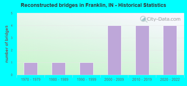
- Reconstructed bridges - Historical Statistics
- 11970-1979
- 11980-1989
- 11990-1999
- 42000-2009
- 42010-2019
- 42020-2022
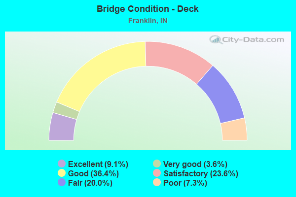
- Bridge Condition - Deck
- 9.1%Excellent
- 3.6%Very good
- 36.4%Good
- 23.6%Satisfactory
- 20.0%Fair
- 7.3%Poor
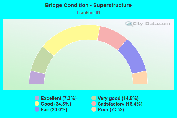
- Bridge Condition - Superstructure
- 7.3%Excellent
- 14.5%Very good
- 34.5%Good
- 16.4%Satisfactory
- 20.0%Fair
- 7.3%Poor
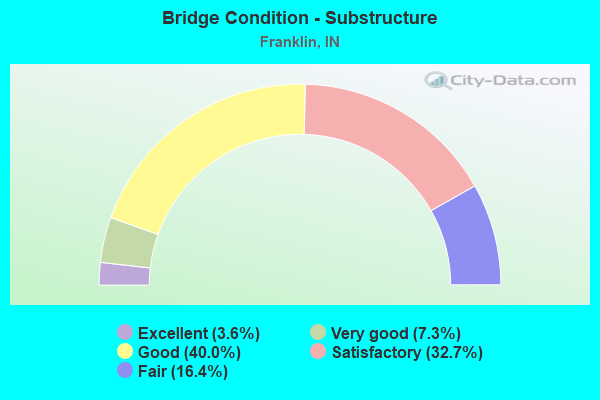
- Bridge Condition - Substructure
- 3.6%Excellent
- 7.3%Very good
- 40.0%Good
- 32.7%Satisfactory
- 16.4%Fair
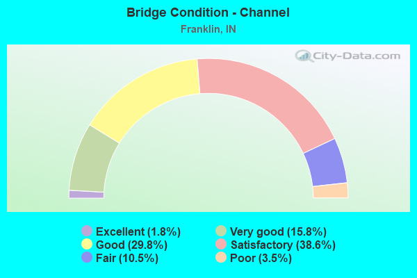
- Bridge Condition - Channel
- 1.8%Excellent
- 15.8%Very good
- 29.8%Good
- 38.6%Satisfactory
- 10.5%Fair
- 3.5%Poor
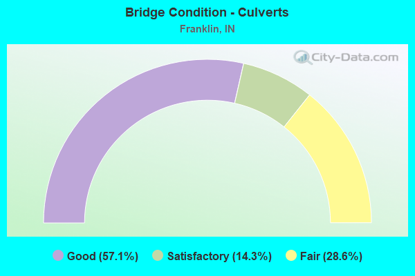
- Bridge Condition - Culverts
- 57.1%Good
- 14.3%Satisfactory
- 28.6%Fair
Find on map >> Show street view
Structure Number: 4100077, Location: 0.01 N OF URMEYVILLE RD (Lat: 39.511819, Lng: -85.969769), Route carried "on" structure: County highway 59, Year Built: 1972, Status: Posted for load, Structure Length: 3.41m (11.19ft), Average Daily Traffic: 254 (year 2019), Truck Traffic: 3%, Average Future Daily Traffic: 469 (year 2039), Features Intersected: LITTLE SUGAR CREEK, Facility Carried by Structure: CR 700 EAST
Minimum Vertical Clearance: 30+ m (98+ ft), Kilometerpoint: 0.000, Lanes on structure: 2, Owner: County Highway Agency, Approaching Roadway Width: 6.7m (22.0ft), Skew: 3 degrees, Material/Design: Prestressed concrete, Design/Construction: Box Beam or Girders - Multiple, Number Of Spans In Main Unit: 2, Length of Maximum Span: 16.7m (54.8ft), Curb or Sidewalk Widths: Left: 0.3m (1.0ft), Right: 0.3m (1.0ft), Curb-To-Curb Width: 8.7m (28.5ft), Out-to-Out Width: 9.3m (30.5ft)
Condition: Deck: Poor, Superstructure: Poor, Substructure: Satisfactory, Channel: Satisfactory, Operating Rating: 17.4 metric tons, Method Used To Determine Operating Rating: Load Factor (LF), Inventory Rating: 10.4 metric tons, Method Used To Determine Inventory Rating: Load Factor (LF), Structural Evaluation: High priority of corrective action, Deck Geometry: Equal to present minimum criteria, Waterway Adequacy: Better than present minimum criteria, Approach Roadway Alignment: Equal to present desirable criteria, Bridge Posting: Required (Relationship of Operating Rating to Maximum Legal Load: > 39.9% below), Length Of Structure Improvement: 3.41m (11.19ft), Designated Inspection Frequency: Every 12 months, Inspection Date: July 2021, Bridge Improvement Cost: $600,000, Roadway Improvement Cost: $300,000, Total Project Cost: $900,000 ( Estimate for 2021), Deck Structure Type: Concrete Precast Panels, Wearing Surface/Protective System: Wearing Surface: Bituminous
Find on map >> Show street view
Structure Number: 4100083, Location: 0.15 E OF CR 625 E (Lat: 39.529831, Lng: -85.982150), Route carried "on" structure: County highway 32, Year Built: 1991, Status: Open, Structure Length: 3.23m (10.60ft), Average Daily Traffic: 431 (year 2016), Truck Traffic: 3%, Average Future Daily Traffic: 827 (year 2036), Design Load: HS 20, Features Intersected: LITTLE SUGAR CREEK, Facility Carried by Structure: CR 350 NORTH
Minimum Vertical Clearance: 30+ m (98+ ft), Kilometerpoint: 0.000, Lanes on structure: 2, Owner: County Highway Agency, Approaching Roadway Width: 7.6m (24.9ft), Skew: 2 degrees, Material/Design: Concrete continuous, Design/Construction: Slab, Number Of Spans In Main Unit: 3, Length of Maximum Span: 12.2m (40.0ft), Curb-To-Curb Width: 9.0m (29.5ft), Out-to-Out Width: 9.4m (30.8ft)
Condition: Deck: Good, Superstructure: Good, Substructure: Satisfactory, Channel: Satisfactory, Operating Rating: 54.5 metric tons, Method Used To Determine Operating Rating: Field evaluation and documented engineering judgment, Inventory Rating: 32.7 metric tons, Method Used To Determine Inventory Rating: Field evaluation and documented engineering judgment, Structural Evaluation: Equal to present minimum criteria, Deck Geometry: Somewhat better than minimum adequacy, Waterway Adequacy: Better than present minimum criteria, Approach Roadway Alignment: Equal to present desirable criteria, Designated Inspection Frequency: Every 24 months, Inspection Date: July 2020, Deck Structure Type: Concrete Cast-file-Place, Wearing Surface/Protective System: Wearing Surface: Monolithic Concrete, Deck Protection: Epoxy Coated Reinforcing
Find on map >> Show street view
Structure Number: 4100087, Location: 0.05 W OF US 31 (Lat: 39.426139, Lng: -86.004850), Route carried "on" structure: County highway 53, Year Built: 1960, Status: Posted for load, Structure Length: 0.73m (2.40ft), Average Daily Traffic: 65 (year 2017), Truck Traffic: 2%, Average Future Daily Traffic: 126 (year 2037), Features Intersected: AMITY DITCH, Facility Carried by Structure: CR 350 SOUTH
Minimum Vertical Clearance: 30+ m (98+ ft), Kilometerpoint: 0.000, Lanes on structure: 2, Owner: County Highway Agency, Approaching Roadway Width: 5.8m (19.0ft), Material/Design: Concrete, Design/Construction: Channel Beam, Number Of Spans In Main Unit: 1, Length of Maximum Span: 6.6m (21.7ft), Curb-To-Curb Width: 6.8m (22.3ft), Out-to-Out Width: 6.9m (22.6ft)
Condition: Deck: Poor, Superstructure: Poor, Substructure: Fair, Channel: Fair, Operating Rating: 47.6 metric tons, Method Used To Determine Operating Rating: Load Factor (LF), Inventory Rating: 28.5 metric tons, Method Used To Determine Inventory Rating: Load Factor (LF), Structural Evaluation: Meets minimum limits, Deck Geometry: Somewhat better than minimum adequacy, Waterway Adequacy: Somewhat better than minimum adequacy, Approach Roadway Alignment: Equal to present desirable criteria, Length Of Structure Improvement: 1.37m (4.49ft), Designated Inspection Frequency: Every 12 months, Inspection Date: July 2021, Bridge Improvement Cost: $250,000, Roadway Improvement Cost: $175,000, Total Project Cost: $425,000 ( Estimate for 2021), Deck Structure Type: Concrete Precast Panels, Wearing Surface/Protective System: Wearing Surface: Bituminous
Find on map >> Show street view
Structure Number: 4100088, Location: 0.50 W OF CR 800 E (Lat: 39.503731, Lng: -85.958419), Route carried "on" structure: County highway 136, Year Built: 1910, Year Reconstructed: 1988, Status: Open, Structure Length: 0.70m (2.30ft), Average Daily Traffic: 20 (year 2012), Truck Traffic: 10%, Average Future Daily Traffic: 30 (year 2032), Features Intersected: BRANCH OF SUGAR CREEK, Facility Carried by Structure: CR 150 NORTH
Minimum Vertical Clearance: 30+ m (98+ ft), Kilometerpoint: 0.000, Lanes on structure: 2, Owner: County Highway Agency, Approaching Roadway Width: 3.7m (12.1ft), Material/Design: Prestressed concrete, Design/Construction: Box Beam or Girders - Multiple, Number Of Spans In Main Unit: 1, Length of Maximum Span: 6.3m (20.7ft), Curb-To-Curb Width: 5.4m (17.7ft), Out-to-Out Width: 5.5m (18.0ft)
Condition: Deck: Good, Superstructure: Good, Substructure: Fair, Channel: Fair, Operating Rating: 64.3 metric tons, Method Used To Determine Operating Rating: Load Factor (LF), Inventory Rating: 38.5 metric tons, Method Used To Determine Inventory Rating: Load Factor (LF), Structural Evaluation: Somewhat better than minimum adequacy, Deck Geometry: High priority of corrective action, Waterway Adequacy: Equal to present desirable criteria, Approach Roadway Alignment: High priority of corrective action, Designated Inspection Frequency: Every 24 months, Inspection Date: July 2020, Deck Structure Type: Concrete Precast Panels, Wearing Surface/Protective System: Wearing Surface: Monolithic Concrete
Find on map >> Show street view
Structure Number: 410009, Location: 0.15 E OF CR 600 E (Lat: 39.582450, Lng: -85.987731), Route carried "on" structure: County highway 50, Year Built: 1978, Status: Posted for load, Structure Length: 0.98m (3.22ft), Average Daily Traffic: 1,950 (year 2019), Truck Traffic: 3%, Average Future Daily Traffic: 2,844 (year 2039), Features Intersected: CAMPBELL DITCH, Facility Carried by Structure: CR 700 NORTH
Minimum Vertical Clearance: 30+ m (98+ ft), Kilometerpoint: 0.000, Lanes on structure: 2, Owner: County Highway Agency, Approaching Roadway Width: 5.5m (18.0ft), Material/Design: Prestressed concrete, Design/Construction: Box Beam or Girders - Multiple, Number Of Spans In Main Unit: 1, Length of Maximum Span: 8.6m (28.2ft), Curb-To-Curb Width: 7.2m (23.6ft), Out-to-Out Width: 7.4m (24.3ft)
Condition: Deck: Fair, Superstructure: Fair, Substructure: Fair, Channel: Satisfactory, Operating Rating: 33.5 metric tons, Method Used To Determine Operating Rating: Load Factor (LF), Inventory Rating: 20.0 metric tons, Method Used To Determine Inventory Rating: Load Factor (LF), Structural Evaluation: Somewhat better than minimum adequacy, Deck Geometry: High priority of corrective action, Waterway Adequacy: Better than present minimum criteria, Approach Roadway Alignment: Equal to present desirable criteria, Length Of Structure Improvement: 1.52m (4.99ft), Designated Inspection Frequency: Every 24 months, Inspection Date: July 2020, Bridge Improvement Cost: $250,000, Roadway Improvement Cost: $150,000, Total Project Cost: $400,000 ( Estimate for 2020), Deck Structure Type: Concrete Precast Panels, Wearing Surface/Protective System: Wearing Surface: Bituminous
Find on map >> Show street view
Structure Number: 4100091, Location: 0.30 E OF CENTER (Lat: 39.514889, Lng: -86.097600), Route carried "on" structure: County highway 146, Year Built: 1982, Status: Open, Structure Length: 0.79m (2.59ft), Average Daily Traffic: 1,701 (year 2018), Truck Traffic: 5%, Average Future Daily Traffic: 2,873 (year 2038), Features Intersected: BREWER DITCH, Facility Carried by Structure: CR 260 NORTH
Minimum Vertical Clearance: 30+ m (98+ ft), Kilometerpoint: 0.000, Lanes on structure: 2, Owner: County Highway Agency, Approaching Roadway Width: 6.1m (20.0ft), Material/Design: Prestressed concrete, Design/Construction: Box Beam or Girders - Multiple, Number Of Spans In Main Unit: 1, Length of Maximum Span: 7.3m (24.0ft), Curb-To-Curb Width: 7.3m (24.0ft), Out-to-Out Width: 7.3m (24.0ft)
Condition: Deck: Satisfactory, Superstructure: Satisfactory, Substructure: Fair, Channel: Poor, Operating Rating: 68.3 metric tons, Method Used To Determine Operating Rating: Load Factor (LF), Inventory Rating: 40.9 metric tons, Method Used To Determine Inventory Rating: Load Factor (LF), Structural Evaluation: Somewhat better than minimum adequacy, Deck Geometry: Meets minimum limits, Waterway Adequacy: Somewhat better than minimum adequacy, Approach Roadway Alignment: Equal to present desirable criteria, Designated Inspection Frequency: Every 24 months, Inspection Date: July 2020, Deck Structure Type: Concrete Precast Panels, Wearing Surface/Protective System: Wearing Surface: Bituminous
Find on map >> Show street view
Structure Number: 4100099, Location: 0.20 E OF HOME AVENUE (Lat: 39.475881, Lng: -86.048700), Route carried "on" structure: City street , Year Built: 1934, Year Reconstructed: 1999, Status: Open, Structure Length: 5.29m (17.36ft), Average Daily Traffic: 4,186 (year 2019), Truck Traffic: 3%, Average Future Daily Traffic: 6,832 (year 2039), Design Load: HS 20, Features Intersected: YOUNGS CREEK, Facility Carried by Structure: SOUTH STREET
Minimum Vertical Clearance: 30+ m (98+ ft), Kilometerpoint: 0.000, Lanes on structure: 2, Owner: County Highway Agency, Approaching Roadway Width: 11.0m (36.1ft), Skew: 3 degrees, Material/Design: Concrete, Design/Construction: Arch - Deck, Number Of Spans In Main Unit: 3, Length of Maximum Span: 17.8m (58.4ft), Curb or Sidewalk Widths: Left: 1.5m (4.9ft), Right: 1.5m (4.9ft), Curb-To-Curb Width: 11.0m (36.1ft), Out-to-Out Width: 14.9m (48.9ft)
Condition: Deck: Fair, Superstructure: Fair, Substructure: Satisfactory, Channel: Very good, Operating Rating: 54.5 metric tons, Method Used To Determine Operating Rating: Field evaluation and documented engineering judgment, Inventory Rating: 32.7 metric tons, Method Used To Determine Inventory Rating: Field evaluation and documented engineering judgment, Structural Evaluation: Somewhat better than minimum adequacy, Deck Geometry: Somewhat better than minimum adequacy, Waterway Adequacy: Better than present minimum criteria, Approach Roadway Alignment: Equal to present desirable criteria, Designated Inspection Frequency: Every 24 months, Inspection Date: July 2020, Deck Structure Type: Concrete Cast-file-Place, Wearing Surface/Protective System: Wearing Surface: Monolithic Concrete
Find on map >> Show street view
Structure Number: 4100102, Location: 0.20 E OF HOME STREET (Lat: 39.479761, Lng: -86.049161), Route carried "on" structure: City street , Year Built: 1971, Year Reconstructed: 2005, Status: Open, Structure Length: 1.83m (6.00ft), Average Daily Traffic: 1,203 (year 2012), Truck Traffic: 2%, Average Future Daily Traffic: 2,125 (year 2032), Features Intersected: HURRICANE CREEK, Facility Carried by Structure: MONROE STREET
Minimum Vertical Clearance: 30+ m (98+ ft), Kilometerpoint: 0.000, Lanes on structure: 2, Owner: County Highway Agency, Approaching Roadway Width: 7.3m (24.0ft), Skew: 3 degrees, Material/Design: Prestressed concrete, Design/Construction: Box Beam or Girders - Multiple, Number Of Spans In Main Unit: 1, Length of Maximum Span: 17.1m (56.1ft), Curb or Sidewalk Widths: Left: 1.5m (4.9ft), Right: 1.5m (4.9ft), Curb-To-Curb Width: 7.3m (24.0ft), Out-to-Out Width: 10.5m (34.4ft)
Condition: Deck: Good, Superstructure: Good, Substructure: Satisfactory, Channel: Good, Operating Rating: 54.3 metric tons, Method Used To Determine Operating Rating: Load Factor (LF), Inventory Rating: 32.5 metric tons, Method Used To Determine Inventory Rating: Load Factor (LF), Structural Evaluation: Equal to present minimum criteria, Deck Geometry: Meets minimum limits, Waterway Adequacy: Better than present minimum criteria, Approach Roadway Alignment: Equal to present desirable criteria, Designated Inspection Frequency: Every 24 months, Inspection Date: July 2020, Deck Structure Type: Concrete Cast-file-Place, Wearing Surface/Protective System: Wearing Surface: Monolithic Concrete, Deck Protection: Epoxy Coated Reinforcing
Find on map >> Show street view
Structure Number: 4100103, Location: 0.30 E OF HOME AVENUE (Lat: 39.482600, Lng: -86.046881), Route carried "on" structure: City street , Year Built: 2002, Status: Open, Structure Length: 2.94m (9.65ft), Average Daily Traffic: 3,853 (year 2020), Truck Traffic: 2%, Average Future Daily Traffic: 6,302 (year 2040), Features Intersected: HURRICANE CREEK, Facility Carried by Structure: KING STREET
Minimum Vertical Clearance: 30+ m (98+ ft), Kilometerpoint: 0.000, Lanes on structure: 2, Owner: County Highway Agency, Approaching Roadway Width: 8.8m (28.9ft), Skew: 3 degrees, Material/Design: Concrete, Design/Construction: Slab, Number Of Spans In Main Unit: 2, Length of Maximum Span: 14.0m (45.9ft), Curb or Sidewalk Widths: Left: 1.4m (4.6ft), Right: 1.4m (4.6ft), Curb-To-Curb Width: 9.1m (29.9ft), Out-to-Out Width: 12.6m (41.3ft)
Condition: Deck: Good, Superstructure: Good, Substructure: Good, Channel: Good, Operating Rating: 54.5 metric tons, Method Used To Determine Operating Rating: Field evaluation and documented engineering judgment, Inventory Rating: 32.7 metric tons, Method Used To Determine Inventory Rating: Field evaluation and documented engineering judgment, Structural Evaluation: Better than present minimum criteria, Deck Geometry: Meets minimum limits, Waterway Adequacy: Better than present minimum criteria, Approach Roadway Alignment: Equal to present desirable criteria, Designated Inspection Frequency: Every 24 months, Inspection Date: July 2020, Deck Structure Type: Concrete Cast-file-Place, Wearing Surface/Protective System: Wearing Surface: Monolithic Concrete, Deck Protection: Epoxy Coated Reinforcing
Find on map >> Show street view
Structure Number: 4100104, Location: 0.20 N OF KING STREET (Lat: 39.485361, Lng: -86.043439), Route carried "on" structure: City street , Year Built: 1970, Status: Open, Structure Length: 1.02m (3.35ft), Average Daily Traffic: 1,976 (year 2020), Truck Traffic: 5%, Average Future Daily Traffic: 3,646 (year 2040), Features Intersected: HURRICANE CREEK, Facility Carried by Structure: FORSYTHE STREET
Minimum Vertical Clearance: 30+ m (98+ ft), Kilometerpoint: 0.000, Lanes on structure: 2, Owner: County Highway Agency, Approaching Roadway Width: 6.4m (21.0ft), Skew: 3 degrees, Material/Design: Steel, Design/Construction: Culvert, Number Of Spans In Main Unit: 2, Length of Maximum Span: 4.4m (14.4ft), Curb-To-Curb Width: 7.6m (24.9ft), Out-to-Out Width: 7.6m (24.9ft)
Condition: Channel: Satisfactory, Culverts: Fair, Operating Rating: 43.6 metric tons, Method Used To Determine Operating Rating: Field evaluation and documented engineering judgment, Inventory Rating: 26.1 metric tons, Method Used To Determine Inventory Rating: Field evaluation and documented engineering judgment, Structural Evaluation: Somewhat better than minimum adequacy, Deck Geometry: Meets minimum limits, Waterway Adequacy: Equal to present minimum criteria, Approach Roadway Alignment: Equal to present desirable criteria, Designated Inspection Frequency: Every 24 months, Inspection Date: July 2020, Wearing Surface/Protective System: Wearing Surface: Bituminous
Find on map >> Show street view
Structure Number: 4100107, Location: 0.10 N OF CR 350 S (Lat: 39.427989, Lng: -86.002339), Route carried "on" structure: County highway 403, Year Built: 1977, Status: Open, Structure Length: 1.22m (4.00ft), Average Daily Traffic: 100 (year 2012), Truck Traffic: 5%, Average Future Daily Traffic: 200 (year 2032), Features Intersected: AMITY DITCH, Facility Carried by Structure: CR 550 EAST
Minimum Vertical Clearance: 30+ m (98+ ft), Kilometerpoint: 0.000, Lanes on structure: 2, Owner: County Highway Agency, Approaching Roadway Width: 4.6m (15.1ft), Material/Design: Prestressed concrete, Design/Construction: Box Beam or Girders - Multiple, Number Of Spans In Main Unit: 1, Length of Maximum Span: 11.2m (36.7ft), Curb-To-Curb Width: 6.0m (19.7ft), Out-to-Out Width: 6.2m (20.3ft)
Condition: Deck: Fair, Superstructure: Fair, Substructure: Fair, Channel: Fair, Operating Rating: 49.5 metric tons, Method Used To Determine Operating Rating: Load Factor (LF), Inventory Rating: 29.7 metric tons, Method Used To Determine Inventory Rating: Load Factor (LF), Structural Evaluation: Somewhat better than minimum adequacy, Deck Geometry: Meets minimum limits, Waterway Adequacy: Equal to present desirable criteria, Approach Roadway Alignment: Equal to present desirable criteria, Designated Inspection Frequency: Every 24 months, Inspection Date: July 2020, Deck Structure Type: Concrete Precast Panels, Wearing Surface/Protective System: Wearing Surface: Bituminous
Find on map >> Show street view
Structure Number: 4100111, Location: 00.40 W OF CR 100 E (Lat: 39.432900, Lng: -86.094089), Route carried "on" structure: County highway 10, Year Built: 1978, Status: Open, Structure Length: 1.10m (3.61ft), Average Daily Traffic: 2,075 (year 2019), Truck Traffic: 5%, Average Future Daily Traffic: 3,890 (year 2039), Features Intersected: VANDIVER DITCH, Facility Carried by Structure: CR 300 SOUTH
Minimum Vertical Clearance: 30+ m (98+ ft), Kilometerpoint: 0.000, Lanes on structure: 2, Owner: County Highway Agency, Approaching Roadway Width: 6.1m (20.0ft), Skew: 5 degrees, Material/Design: Prestressed concrete, Design/Construction: Box Beam or Girders - Multiple, Number Of Spans In Main Unit: 1, Length of Maximum Span: 9.9m (32.5ft), Curb or Sidewalk Widths: Left: 0.3m (1.0ft), Right: 0.3m (1.0ft), Curb-To-Curb Width: 7.5m (24.6ft), Out-to-Out Width: 8.1m (26.6ft)
Condition: Deck: Fair, Superstructure: Fair, Substructure: Satisfactory, Channel: Satisfactory, Operating Rating: 45.3 metric tons, Method Used To Determine Operating Rating: Load and Resistance Factor (LRFR), Inventory Rating: 37.6 metric tons, Method Used To Determine Inventory Rating: Load and Resistance Factor (LRFR), Structural Evaluation: Somewhat better than minimum adequacy, Deck Geometry: High priority of replacement, Waterway Adequacy: Equal to present minimum criteria, Approach Roadway Alignment: Equal to present desirable criteria, Length Of Structure Improvement: 1.83m (6.00ft), Designated Inspection Frequency: Every 24 months, Inspection Date: July 2020, Bridge Improvement Cost: $325,000, Roadway Improvement Cost: $175,000, Total Project Cost: $500,000 ( Estimate for 2020), Deck Structure Type: Concrete Precast Panels, Wearing Surface/Protective System: Wearing Surface: Bituminous
Find on map >> Show street view
Structure Number: 4100121, Location: 0.40 N OF SR 44 (Lat: 39.487989, Lng: -86.083769), Route carried "on" structure: City street , Year Built: 1986, Status: Open, Structure Length: 3.19m (10.47ft), Average Daily Traffic: 7,266 (year 2019), Truck Traffic: 4%, Average Future Daily Traffic: 12,620 (year 2039), Features Intersected: CANARY DITCH, Facility Carried by Structure: WESTVIEW DRIVE
Minimum Vertical Clearance: 30+ m (98+ ft), Kilometerpoint: 0.000, Lanes on structure: 2, Owner: County Highway Agency, Approaching Roadway Width: 9.8m (32.2ft), Skew: 3 degrees, Material/Design: Prestressed concrete continuous, Design/Construction: Box Beam or Girders - Single/Spread, Number Of Spans In Main Unit: 2, Length of Maximum Span: 15.3m (50.2ft), Curb-To-Curb Width: 10.0m (32.8ft), Out-to-Out Width: 10.7m (35.1ft)
Condition: Deck: Satisfactory, Superstructure: Fair, Substructure: Satisfactory, Channel: Fair, Operating Rating: 51.8 metric tons, Method Used To Determine Operating Rating: Field evaluation and documented engineering judgment, Inventory Rating: 31.0 metric tons, Method Used To Determine Inventory Rating: Field evaluation and documented engineering judgment, Structural Evaluation: Somewhat better than minimum adequacy, Deck Geometry: Meets minimum limits, Waterway Adequacy: Equal to present desirable criteria, Approach Roadway Alignment: Equal to present minimum criteria, Designated Inspection Frequency: Every 24 months, Inspection Date: July 2020, Deck Structure Type: Concrete Cast-file-Place, Wearing Surface/Protective System: Wearing Surface: Bituminous
Find on map >> Show street view
Structure Number: 4100122, Location: 0.20 W OF US 31 (Lat: 39.494050, Lng: -86.068381), Route carried "on" structure: City street , Year Built: 1986, Status: Open, Structure Length: 2.04m (6.69ft), Average Daily Traffic: 10,706 (year 2012), Truck Traffic: 4%, Average Future Daily Traffic: 15,000 (year 2032), Design Load: HS 20, Features Intersected: CANARY DITCH, Facility Carried by Structure: WESTVIEW DRIVE
Minimum Vertical Clearance: 30+ m (98+ ft), Kilometerpoint: 0.000, Lanes on structure: 2, Owner: County Highway Agency, Approaching Roadway Width: 9.8m (32.2ft), Skew: 1 degrees, Material/Design: Prestressed concrete, Design/Construction: Box Beam or Girders - Single/Spread, Number Of Spans In Main Unit: 1, Length of Maximum Span: 19.2m (63.0ft), Curb-To-Curb Width: 9.8m (32.2ft), Out-to-Out Width: 10.6m (34.8ft)
Condition: Deck: Fair, Superstructure: Fair, Substructure: Satisfactory, Channel: Satisfactory, Operating Rating: 69.6 metric tons, Method Used To Determine Operating Rating: Load and Resistance Factor (LRFR), Inventory Rating: 30.9 metric tons, Method Used To Determine Inventory Rating: Load and Resistance Factor (LRFR), Structural Evaluation: Somewhat better than minimum adequacy, Deck Geometry: Meets minimum limits, Waterway Adequacy: Better than present minimum criteria, Approach Roadway Alignment: Equal to present desirable criteria, Designated Inspection Frequency: Every 24 months, Inspection Date: July 2020, Deck Structure Type: Concrete Cast-file-Place, Wearing Surface/Protective System: Wearing Surface: Monolithic Concrete
Find on map >> Show street view
Structure Number: 4100123, Location: 0.10 N OF CR 100 N (Lat: 39.491231, Lng: -86.034261), Route carried "on" structure: City street , Year Built: 1987, Status: Open, Structure Length: 3.21m (10.53ft), Average Daily Traffic: 4,753 (year 2012), Truck Traffic: 5%, Average Future Daily Traffic: 6,500 (year 2032), Design Load: HS 20, Features Intersected: HURRICANE CREEK, Facility Carried by Structure: EASTVIEW DRIVE
Minimum Vertical Clearance: 30+ m (98+ ft), Kilometerpoint: 0.000, Lanes on structure: 2, Owner: County Highway Agency, Approaching Roadway Width: 9.1m (29.9ft), Material/Design: Prestressed concrete continuous, Design/Construction: Box Beam or Girders - Single/Spread, Number Of Spans In Main Unit: 3, Length of Maximum Span: 10.8m (35.4ft), Curb-To-Curb Width: 9.8m (32.2ft), Out-to-Out Width: 10.6m (34.8ft)
Condition: Deck: Fair, Superstructure: Satisfactory, Substructure: Fair, Channel: Very good, Operating Rating: 64.9 metric tons, Method Used To Determine Operating Rating: Load Factor (LF), Inventory Rating: 38.9 metric tons, Method Used To Determine Inventory Rating: Load Factor (LF), Structural Evaluation: Somewhat better than minimum adequacy, Deck Geometry: Meets minimum limits, Waterway Adequacy: Equal to present desirable criteria, Approach Roadway Alignment: Equal to present desirable criteria, Designated Inspection Frequency: Every 24 months, Inspection Date: July 2020, Deck Structure Type: Concrete Cast-file-Place, Wearing Surface/Protective System: Wearing Surface: Monolithic Concrete
Find on map >> Show street view
Structure Number: 4100155, Location: 0.70 E OF CR 510 E (Lat: 39.442400, Lng: -85.992381), Route carried "on" structure: County highway 12, Year Built: 1999, Status: Open, Structure Length: 0.93m (3.05ft), Average Daily Traffic: 294 (year 2019), Truck Traffic: 2%, Average Future Daily Traffic: 484 (year 2039), Design Load: HS 20, Features Intersected: AMITY DITCH, Facility Carried by Structure: CR 250 SOUTH
Minimum Vertical Clearance: 30+ m (98+ ft), Kilometerpoint: 0.000, Lanes on structure: 2, Owner: County Highway Agency, Approaching Roadway Width: 5.8m (19.0ft), Skew: 1 degrees, Material/Design: Concrete, Design/Construction: Culvert, Number Of Spans In Main Unit: 1, Length of Maximum Span: 8.7m (28.5ft), Curb-To-Curb Width: 7.3m (24.0ft), Out-to-Out Width: 7.3m (24.0ft)
Condition: Channel: Satisfactory, Culverts: Good, Operating Rating: 54.5 metric tons, Method Used To Determine Operating Rating: Field evaluation and documented engineering judgment, Inventory Rating: 32.7 metric tons, Method Used To Determine Inventory Rating: Field evaluation and documented engineering judgment, Structural Evaluation: Better than present minimum criteria, Deck Geometry: Somewhat better than minimum adequacy, Waterway Adequacy: Better than present minimum criteria, Approach Roadway Alignment: Equal to present desirable criteria, Designated Inspection Frequency: Every 24 months, Inspection Date: July 2020, Wearing Surface/Protective System: Wearing Surface: Bituminous
Find on map >> Show street view
Structure Number: 4100205, Location: 0.50 N OF CR 200 N (Lat: 39.513661, Lng: -86.115161), Route carried "on" structure: County highway 35, Year Built: 2002, Status: Open, Structure Length: 1.26m (4.13ft), Average Daily Traffic: 324 (year 2012), Truck Traffic: 2%, Average Future Daily Traffic: 438 (year 2032), Design Load: HS 20, Features Intersected: RA ARMSTRONG DITCH, Facility Carried by Structure: CR 75 WEST
Minimum Vertical Clearance: 30+ m (98+ ft), Kilometerpoint: 0.000, Lanes on structure: 2, Owner: County Highway Agency, Approaching Roadway Width: 6.7m (22.0ft), Skew: 3 degrees, Material/Design: Prestressed concrete, Design/Construction: Box Beam or Girders - Single/Spread, Number Of Spans In Main Unit: 1, Length of Maximum Span: 10.9m (35.8ft), Curb-To-Curb Width: 9.1m (29.9ft), Out-to-Out Width: 9.3m (30.5ft)
Condition: Deck: Good, Superstructure: Good, Substructure: Good, Channel: Satisfactory, Operating Rating: 58.9 metric tons, Method Used To Determine Operating Rating: Load and Resistance Factor (LRFR), Inventory Rating: 47.8 metric tons, Method Used To Determine Inventory Rating: Load and Resistance Factor (LRFR), Structural Evaluation: Better than present minimum criteria, Deck Geometry: Equal to present minimum criteria, Waterway Adequacy: Better than present minimum criteria, Approach Roadway Alignment: Equal to present desirable criteria, Designated Inspection Frequency: Every 24 months, Inspection Date: July 2020, Deck Structure Type: Concrete Cast-file-Place, Wearing Surface/Protective System: Wearing Surface: Monolithic Concrete, Deck Protection: Epoxy Coated Reinforcing
Find on map >> Show street view
Structure Number: 410061, Location: 0.07 W OF BLUE GRASS (Lat: 39.600381, Lng: -86.090611), Route carried "on" structure: City street , Year Built: 2002, Status: Open, Structure Length: 1.02m (3.35ft), Average Daily Traffic: 343 (year 2010), Truck Traffic: 5%, Average Future Daily Traffic: 525 (year 2032), Design Load: HS 20, Features Intersected: GRASSY CREEK, Facility Carried by Structure: CROSS WIND DRIVE
Minimum Vertical Clearance: 30+ m (98+ ft), Kilometerpoint: 0.000, Lanes on structure: 2, Owner: County Highway Agency, Approaching Roadway Width: 9.4m (30.8ft), Skew: 1 degrees, Material/Design: Steel, Design/Construction: Stringer/Multi-beam, Number Of Spans In Main Unit: 1, Length of Maximum Span: 8.9m (29.2ft), Curb or Sidewalk Widths: Left: 1.8m (5.9ft), Right: 1.8m (5.9ft), Curb-To-Curb Width: 9.8m (32.2ft), Out-to-Out Width: 13.5m (44.3ft)
Condition: Deck: Good, Superstructure: Good, Substructure: Good, Channel: Good, Operating Rating: 42.1 metric tons, Method Used To Determine Operating Rating: Load Factor (LF), Inventory Rating: 25.2 metric tons, Method Used To Determine Inventory Rating: Load Factor (LF), Structural Evaluation: Equal to present minimum criteria, Deck Geometry: Better than present minimum criteria, Waterway Adequacy: Equal to present minimum criteria, Approach Roadway Alignment: Equal to present desirable criteria, Designated Inspection Frequency: Every 24 months, Inspection Date: July 2020, Deck Structure Type: Concrete Cast-file-Place, Wearing Surface/Protective System: Wearing Surface: Monolithic Concrete, Deck Protection: Epoxy Coated Reinforcing
Find on map >> Show street view
Structure Number: 4100617, Location: 1.20 W OF US 31 (Lat: 39.507550, Lng: -86.087731), Route carried "on" structure: County highway 28, Year Built: 2006, Status: Open, Structure Length: 0.98m (3.22ft), Average Daily Traffic: 1,848 (year 2012), Truck Traffic: 5%, Average Future Daily Traffic: 2,525 (year 2032), Features Intersected: POWEL DITCH, Facility Carried by Structure: CR 200 NORTH
Minimum Vertical Clearance: 30+ m (98+ ft), Kilometerpoint: 0.000, Lanes on structure: 2, Owner: County Highway Agency, Approaching Roadway Width: 7.6m (24.9ft), Skew: 3 degrees, Material/Design: Concrete, Design/Construction: Culvert, Number Of Spans In Main Unit: 1, Length of Maximum Span: 9.2m (30.2ft), Curb-To-Curb Width: 15.7m (51.5ft), Out-to-Out Width: 15.7m (51.5ft)
Condition: Channel: Good, Culverts: Good, Operating Rating: 54.5 metric tons, Method Used To Determine Operating Rating: Field evaluation and documented engineering judgment, Inventory Rating: 32.7 metric tons, Method Used To Determine Inventory Rating: Field evaluation and documented engineering judgment, Structural Evaluation: Better than present minimum criteria, Deck Geometry: Superior to present desirable criteria, Waterway Adequacy: Better than present minimum criteria, Approach Roadway Alignment: Equal to present desirable criteria, Designated Inspection Frequency: Every 24 months, Inspection Date: July 2020, Wearing Surface/Protective System: Wearing Surface: Bituminous
Find on map >> Show street view
Structure Number: 4100619, Location: 0.60 E OF US 31 (Lat: 39.507550, Lng: -86.060219), Route carried "on" structure: City street , Year Built: 2000, Status: Open, Structure Length: 1.19m (3.90ft), Average Daily Traffic: 9,905 (year 2019), Truck Traffic: 8%, Average Future Daily Traffic: 15,149 (year 2039), Design Load: HS 20, Features Intersected: CANARY DITCH, Facility Carried by Structure: COMMERCE DRIVE
Minimum Vertical Clearance: 30+ m (98+ ft), Kilometerpoint: 0.000, Lanes on structure: 2, Owner: City or Municipal Highway Agency, Maintenance Responsibility: County Highway Agency, Approaching Roadway Width: 7.6m (24.9ft), Material/Design: Prestressed concrete, Design/Construction: Box Beam or Girders - Single/Spread, Number Of Spans In Main Unit: 1, Length of Maximum Span: 10.1m (33.1ft), Curb-To-Curb Width: 11.0m (36.1ft), Out-to-Out Width: 11.1m (36.4ft)
Condition: Deck: Satisfactory, Superstructure: Very good, Substructure: Satisfactory, Channel: Satisfactory, Operating Rating: 51.5 metric tons, Method Used To Determine Operating Rating: Load Factor (LF), Inventory Rating: 30.8 metric tons, Method Used To Determine Inventory Rating: Load Factor (LF), Structural Evaluation: Equal to present minimum criteria, Deck Geometry: Meets minimum limits, Waterway Adequacy: Equal to present minimum criteria, Approach Roadway Alignment: Equal to present desirable criteria, Designated Inspection Frequency: Every 24 months, Inspection Date: July 2020, Deck Structure Type: Concrete Cast-file-Place, Wearing Surface/Protective System: Wearing Surface: Monolithic Concrete, Deck Protection: Epoxy Coated Reinforcing
Find on map >> Show street view
Structure Number: 4100631, Location: 0.10 N OF SOUTH STREET (Lat: 39.477239, Lng: -86.055119), Route carried "on" structure: City street , Year Built: 2017, Status: Open, Structure Length: 4.48m (14.70ft), Average Daily Traffic: 1,799 (year 2012), Truck Traffic: 5%, Average Future Daily Traffic: 3,000 (year 2032), Design Load: HL 93, Features Intersected: YOUNGS CREEK, Facility Carried by Structure: MAIN STREET
Minimum Vertical Clearance: 30+ m (98+ ft), Kilometerpoint: 0.000, Lanes on structure: 2, Owner: County Highway Agency, Approaching Roadway Width: 10.1m (33.1ft), Material/Design: Steel continuous, Design/Construction: Stringer/Multi-beam, Number Of Spans In Main Unit: 3, Length of Maximum Span: 20.7m (67.9ft), Curb or Sidewalk Widths: Left: 3.4m (11.2ft), Right: 3.4m (11.2ft), Curb-To-Curb Width: 8.5m (27.9ft), Out-to-Out Width: 15.4m (50.5ft)
Condition: Deck: Very good, Superstructure: Very good, Substructure: Very good, Channel: Very good, Operating Rating: 89.8 metric tons, Method Used To Determine Operating Rating: Load and Resistance Factor (LRFR), Inventory Rating: 74.4 metric tons, Method Used To Determine Inventory Rating: Load and Resistance Factor (LRFR), Structural Evaluation: Equal to present desirable criteria, Deck Geometry: Somewhat better than minimum adequacy, Waterway Adequacy: Equal to present desirable criteria, Approach Roadway Alignment: Equal to present desirable criteria, Designated Inspection Frequency: Every 24 months, Inspection Date: July 2020, Deck Structure Type: Concrete Cast-file-Place, Wearing Surface/Protective System: Wearing Surface: Monolithic Concrete
Find on map >> Show street view
Structure Number: 4100633, Location: 0.10 E OF CR 75 W (Lat: 39.507089, Lng: -86.113100), Route carried "on" structure: County highway 28, Year Built: 2019, Status: Open, Structure Length: 5.13m (16.83ft), Average Daily Traffic: 1,964 (year 2017), Truck Traffic: 4%, Average Future Daily Traffic: 3,555 (year 2036), Design Load: HL 93, Features Intersected: YOUNGS CREEK, Facility Carried by Structure: CR 200 NORTH
Minimum Vertical Clearance: 30+ m (98+ ft), Kilometerpoint: 0.000, Lanes on structure: 2, Owner: County Highway Agency, Approaching Roadway Width: 9.4m (30.8ft), Material/Design: Prestressed concrete continuous, Design/Construction: Box Beam or Girders - Single/Spread, Number Of Spans In Main Unit: 3, Length of Maximum Span: 16.9m (55.4ft), Curb-To-Curb Width: 10.9m (35.8ft), Out-to-Out Width: 11.5m (37.7ft)
Condition: Deck: Very good, Superstructure: Very good, Substructure: Very good, Channel: Very good, Operating Rating: 49.8 metric tons, Method Used To Determine Operating Rating: Load and Resistance Factor (LRFR), Inventory Rating: 41.3 metric tons, Method Used To Determine Inventory Rating: Load and Resistance Factor (LRFR), Structural Evaluation: Equal to present desirable criteria, Deck Geometry: Equal to present minimum criteria, Waterway Adequacy: Equal to present desirable criteria, Approach Roadway Alignment: Equal to present desirable criteria, Designated Inspection Frequency: Every 24 months, Inspection Date: July 2020, Deck Structure Type: Concrete Cast-file-Place, Wearing Surface/Protective System: Wearing Surface: Monolithic Concrete, Deck Protection: Epoxy Coated Reinforcing
Find on map >> Show street view
Structure Number: 3576, Location: 03.13 S SR 44 (Lat: 39.442550, Lng: -85.988028), Route carried "under" structure: Interstate 65, Year Built: 1970, Structure Length: 0. m, Average Daily Traffic: 20,374 (year 2004), Truck Traffic: 10%, Features Intersected: I-65 NB, Facility Carried by Structure: CR 250S
Minimum Vertical Clearance: 4.85m (15.91ft), Kilometerpoint: 139.063, Lanes on structure: 2, Lanes under structure: 4, Material/Design: Steel continuous, Design/Construction: Stringer/Multi-beam, Length of Maximum Span: 30.1m (98.8ft)
Find on map >> Show street view
Structure Number: 3576, Location: 03.13 S SR 44 (Lat: 39.442550, Lng: -85.988028), Route carried "under" structure: Interstate 65, Year Built: 1970, Structure Length: 0. m, Average Daily Traffic: 20,374 (year 2004), Truck Traffic: 10%, Features Intersected: I-65 SB, Facility Carried by Structure: CR 250S
Minimum Vertical Clearance: 4.88m (16.01ft), Kilometerpoint: 139.063, Lanes on structure: 2, Lanes under structure: 4, Material/Design: Steel continuous, Design/Construction: Stringer/Multi-beam, Length of Maximum Span: 30.1m (98.8ft)
Find on map >> Show street view
Structure Number: 3579, Location: 02.15 S SR 44 (Lat: 39.454669, Lng: -85.998406), Route carried "under" structure: Interstate 65, Year Built: 1970, Structure Length: 0. m, Average Daily Traffic: 20,374 (year 2004), Truck Traffic: 10%, Features Intersected: I-65 NB, Facility Carried by Structure: GREENSBURG ROAD
Minimum Vertical Clearance: 4.85m (15.91ft), Kilometerpoint: 140.641, Lanes on structure: 2, Lanes under structure: 4, Material/Design: Steel continuous, Design/Construction: Stringer/Multi-beam, Length of Maximum Span: 50.4m (165.4ft)
Find on map >> Show street view
Structure Number: 3579, Location: 02.15 S SR 44 (Lat: 39.454669, Lng: -85.998406), Route carried "under" structure: Interstate 65, Year Built: 1970, Structure Length: 0. m, Average Daily Traffic: 27,587 (year 2004), Truck Traffic: 10%, Features Intersected: I-65 SB, Facility Carried by Structure: GREENSBURG ROAD
Minimum Vertical Clearance: 4.95m (16.24ft), Kilometerpoint: 140.641, Lanes on structure: 2, Lanes under structure: 4, Material/Design: Steel continuous, Design/Construction: Stringer/Multi-beam, Length of Maximum Span: 50.4m (165.4ft)
Find on map >> Show street view
Structure Number: 358, Location: 09.48 N SR 252 (Lat: 39.483219, Lng: -86.013742), Route carried "under" structure: State highway 44, Year Built: 1970, Structure Length: 0. m, Average Daily Traffic: 5,558 (year 2004), Truck Traffic: 10%, Features Intersected: SR 44 EB, Facility Carried by Structure: I-65 NB
Minimum Vertical Clearance: 4.50m (14.76ft), Kilometerpoint: 22.483, Lanes on structure: 3, Lanes under structure: 5, Material/Design: Steel continuous, Design/Construction: Stringer/Multi-beam, Length of Maximum Span: 30.0m (98.4ft)
Find on map >> Show street view
Structure Number: 358, Location: 09.48 N SR 252 (Lat: 39.483219, Lng: -86.013742), Route carried "under" structure: State highway 44, Year Built: 1970, Structure Length: 0. m, Average Daily Traffic: 5,558 (year 2004), Truck Traffic: 10%, Features Intersected: SR 44 WB, Facility Carried by Structure: I-65 NB
Minimum Vertical Clearance: 4.50m (14.76ft), Kilometerpoint: 22.483, Lanes on structure: 3, Lanes under structure: 5, Material/Design: Steel continuous, Design/Construction: Stringer/Multi-beam, Length of Maximum Span: 30.0m (98.4ft)
Find on map >> Show street view
Structure Number: 3581, Location: 09.48 N SR 252 (Lat: 39.483211, Lng: -86.014053), Route carried "under" structure: State highway 44, Year Built: 1970, Structure Length: 0. m, Average Daily Traffic: 5,558 (year 2004), Truck Traffic: 10%, Features Intersected: SR 44 EB, Facility Carried by Structure: I-65 SB
Minimum Vertical Clearance: 4.50m (14.76ft), Kilometerpoint: 22.450, Lanes on structure: 2, Lanes under structure: 5, Material/Design: Steel continuous, Design/Construction: Stringer/Multi-beam, Length of Maximum Span: 30.0m (98.4ft)
Find on map >> Show street view
Structure Number: 3581, Location: 09.48 N SR 252 (Lat: 39.483211, Lng: -86.014053), Route carried "under" structure: State highway 44, Year Built: 1970, Structure Length: 0. m, Average Daily Traffic: 5,558 (year 2004), Truck Traffic: 10%, Features Intersected: SR 44 WB, Facility Carried by Structure: I-65 SB
Minimum Vertical Clearance: 4.50m (14.76ft), Kilometerpoint: 22.450, Lanes on structure: 2, Lanes under structure: 5, Material/Design: Steel continuous, Design/Construction: Stringer/Multi-beam, Length of Maximum Span: 30.0m (98.4ft)
Find on map >> Show street view
Structure Number: 3582, Location: 00.92 N SR-44 (Lat: 39.496269, Lng: -86.017539), Route carried "under" structure: Interstate 65, Year Built: 1971, Structure Length: 0. m, Average Daily Traffic: 27,587 (year 2004), Truck Traffic: 10%, Features Intersected: I-65 NBL, Facility Carried by Structure: CR 100N
Minimum Vertical Clearance: 4.90m (16.08ft), Kilometerpoint: 145.581, Lanes on structure: 2, Lanes under structure: 6, Material/Design: Steel continuous, Design/Construction: Stringer/Multi-beam, Length of Maximum Span: 31.7m (104.0ft)
Find on map >> Show street view
Structure Number: 3582, Location: 00.92 N SR-44 (Lat: 39.496269, Lng: -86.017539), Route carried "under" structure: Interstate 65, Year Built: 1971, Structure Length: 0. m, Average Daily Traffic: 27,587 (year 2004), Truck Traffic: 10%, Features Intersected: I-65 SBL, Facility Carried by Structure: CR 100N
Minimum Vertical Clearance: 4.90m (16.08ft), Kilometerpoint: 145.581, Lanes on structure: 2, Lanes under structure: 6, Material/Design: Steel continuous, Design/Construction: Stringer/Multi-beam, Length of Maximum Span: 31.7m (104.0ft)
Find on map >> Show street view
Structure Number: 3583, Location: 02.67 N SR 44 (Lat: 39.521450, Lng: -86.024619), Route carried "under" structure: Interstate 65, Year Built: 1971, Structure Length: 0. m, Average Daily Traffic: 27,587 (year 2004), Truck Traffic: 10%, Features Intersected: I-65 SB, Facility Carried by Structure: CR 300N
Minimum Vertical Clearance: 5.21m (17.09ft), Kilometerpoint: 148.398, Lanes on structure: 2, Lanes under structure: 6, Material/Design: Steel continuous, Design/Construction: Stringer/Multi-beam, Length of Maximum Span: 32.5m (106.6ft)
Find on map >> Show street view
Structure Number: 3583, Location: 02.67 N SR 44 (Lat: 39.521450, Lng: -86.024619), Route carried "under" structure: Interstate 65, Year Built: 1971, Structure Length: 0. m, Average Daily Traffic: 27,587 (year 2004), Truck Traffic: 10%, Features Intersected: I-65 NB, Facility Carried by Structure: CR 300N
Minimum Vertical Clearance: 4.93m (16.17ft), Kilometerpoint: 148.398, Lanes on structure: 2, Lanes under structure: 6, Material/Design: Steel continuous, Design/Construction: Stringer/Multi-beam, Length of Maximum Span: 32.5m (106.6ft)