Bridge Statistics for Franklin, North Carolina (NC)
Condition, Traffic, Stress, Structural Evaluation, Project Costs
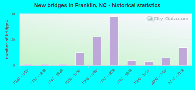
- New bridges - historical statistics
- 11920-1929
- 11930-1939
- 11940-1949
- 101950-1959
- 221960-1969
- 381970-1979
- 41980-1989
- 31990-1999
- 62000-2009
- 142010-2019

- Reconstructed bridges - Historical Statistics
- 31960-1969
- 41970-1979
- 11980-1989
- 01990-1999
- 02000-2009
- 22010-2019


- Bridge Condition - Deck
- 14.1%Very good
- 48.4%Good
- 21.9%Satisfactory
- 14.1%Fair
- 1.6%Poor

- Bridge Condition - Superstructure
- 18.8%Very good
- 17.2%Good
- 34.4%Satisfactory
- 20.3%Fair
- 9.4%Poor

- Bridge Condition - Substructure
- 15.6%Very good
- 25.0%Good
- 37.5%Satisfactory
- 17.2%Fair
- 4.7%Poor

- Bridge Condition - Channel
- 10.8%Very good
- 74.7%Good
- 10.8%Satisfactory
- 3.6%Fair

- Bridge Condition - Culverts
- 24.0%Very good
- 32.0%Good
- 16.0%Satisfactory
- 24.0%Fair
- 4.0%Poor
Find on map >> Show street view
Structure Number: 1130001, Location: .01 MI.W.JCT.SR1001 (Lat: 35.166197, Lng: -83.307331), Route carried "on" structure: State highway 1524, Year Built: 1967, Status: Posted for load, Structure Length: 1.40m (4.59ft), Average Daily Traffic: 780 (year 2014), Truck Traffic: 6%, Average Future Daily Traffic: 1,560 (year 2040), Features Intersected: ELLIJAY CREEK
Minimum Vertical Clearance: 30+ m (98+ ft), Kilometerpoint: 0.000, Lanes on structure: 2, Owner: State Highway Agency, Approaching Roadway Width: 6.4m (21.0ft), Material/Design: Steel continuous, Design/Construction: Stringer/Multi-beam, Number Of Spans In Main Unit: 2, Length of Maximum Span: 7.9m (25.9ft), Curb-To-Curb Width: 7.4m (24.3ft), Out-to-Out Width: 7.7m (25.3ft)
Condition: Deck: Good, Superstructure: Poor, Substructure: Good, Channel: Good, Operating Rating: 22.6 metric tons, Method Used To Determine Operating Rating: Load Factor (LF), Inventory Rating: 13.6 metric tons, Method Used To Determine Inventory Rating: Load Factor (LF), Structural Evaluation: Meets minimum limits, Deck Geometry: Meets minimum limits, Waterway Adequacy: Better than present minimum criteria, Approach Roadway Alignment: Equal to present minimum criteria, Bridge Posting: Required (Relationship of Operating Rating to Maximum Legal Load: > 39.9% below), Designated Inspection Frequency: Every 24 months, Inspection Date: August 2020, Deck Structure Type: Wood or Timber, Wearing Surface/Protective System: Wearing Surface: Bituminous
Find on map >> Show street view
Structure Number: 1130002, Location: 40 FT.N.JCT.SR1526 (Lat: 35.169461, Lng: -83.302878), Route carried "on" structure: State highway 1001, Year Built: 1957, Year Reconstructed: 1982, Status: Posted for load, Structure Length: 1.52m (4.99ft), Average Daily Traffic: 950 (year 2019), Truck Traffic: 6%, Average Future Daily Traffic: 1,900 (year 2040), Features Intersected: ELLIJAY CREEK
Minimum Vertical Clearance: 30+ m (98+ ft), Kilometerpoint: 0.000, Lanes on structure: 2, Owner: State Highway Agency, Approaching Roadway Width: 5.4m (17.7ft), Material/Design: Steel, Design/Construction: Stringer/Multi-beam, Number Of Spans In Main Unit: 2, Length of Maximum Span: 10.3m (33.8ft), Curb-To-Curb Width: 5.8m (19.0ft), Out-to-Out Width: 6.0m (19.7ft)
Condition: Deck: Good, Superstructure: Poor, Substructure: Fair, Channel: Good, Operating Rating: 32.6 metric tons, Method Used To Determine Operating Rating: Allowable Stress (AS), Inventory Rating: 19.0 metric tons, Method Used To Determine Inventory Rating: Allowable Stress (AS), Structural Evaluation: Meets minimum limits, Deck Geometry: High priority of replacement, Waterway Adequacy: Better than present minimum criteria, Approach Roadway Alignment: Equal to present desirable criteria, Bridge Posting: Required (Relationship of Operating Rating to Maximum Legal Load: 10.0 - 19.9% below), Designated Inspection Frequency: Every 24 months, Inspection Date: September 2020, Deck Structure Type: Wood or Timber, Wearing Surface/Protective System: Wearing Surface: Bituminous
Find on map >> Show street view
Structure Number: 1130003, Location: .01 MI.S.JCT.SR1001 (Lat: 35.172217, Lng: -83.298589), Route carried "on" structure: State highway 1526, Year Built: 1961, Status: Posted for load, Structure Length: 1.24m (4.07ft), Average Daily Traffic: 8,300 (year 2019), Truck Traffic: 6%, Average Future Daily Traffic: 16,600 (year 2040), Features Intersected: ELLIJAY CREEK
Minimum Vertical Clearance: 30+ m (98+ ft), Kilometerpoint: 0.000, Lanes on structure: 2, Owner: State Highway Agency, Approaching Roadway Width: 3.6m (11.8ft), Skew: 3 degrees, Material/Design: Steel, Design/Construction: Stringer/Multi-beam, Number Of Spans In Main Unit: 1, Length of Maximum Span: 11.8m (38.7ft), Curb-To-Curb Width: 5.8m (19.0ft), Out-to-Out Width: 6.1m (20.0ft)
Condition: Deck: Good, Superstructure: Satisfactory, Substructure: Satisfactory, Channel: Good, Operating Rating: 21.7 metric tons, Method Used To Determine Operating Rating: Load Factor (LF), Inventory Rating: 12.7 metric tons, Method Used To Determine Inventory Rating: Load Factor (LF), Structural Evaluation: High priority of corrective action, Deck Geometry: High priority of replacement, Waterway Adequacy: Equal to present minimum criteria, Approach Roadway Alignment: Equal to present desirable criteria, Bridge Posting: Required (Relationship of Operating Rating to Maximum Legal Load: > 39.9% below), Designated Inspection Frequency: Every 24 months, Inspection Date: September 2020, Deck Structure Type: Wood or Timber, Wearing Surface/Protective System: Wearing Surface: Bituminous
Find on map >> Show street view
Structure Number: 1130005, Location: 150 FT.N.JCT.SR1119 (Lat: 35.083569, Lng: -83.384181), Route carried "on" structure: US 23, Year Built: 1956, Status: Open, Structure Length: 1.61m (5.28ft), Average Daily Traffic: 9,500 (year 2013), Truck Traffic: 14%, Average Future Daily Traffic: 19,000 (year 2040), Design Load: HS 20+Mod, Features Intersected: COWEETA CREEK
Minimum Vertical Clearance: 30+ m (98+ ft), Kilometerpoint: 0.000, Lanes on structure: 5, Base Highway Network: Yes (Inventory Route: 2, Subroute: 23), Owner: State Highway Agency, Approaching Roadway Width: 21.3m (69.9ft), Skew: 21 degrees, Material/Design: Concrete continuous, Design/Construction: Culvert, Number Of Spans In Main Unit: 4, Length of Maximum Span: 3.3m (10.8ft)
Condition: Channel: Good, Culverts: Good, Operating Rating: 89.8 metric tons, Method Used To Determine Operating Rating: Load Factor (LF), Inventory Rating: 57.1 metric tons, Method Used To Determine Inventory Rating: Load Factor (LF), Structural Evaluation: Better than present minimum criteria, Waterway Adequacy: Better than present minimum criteria, Approach Roadway Alignment: Equal to present minimum criteria, Designated Inspection Frequency: Every 24 months, Inspection Date: September 2020
Find on map >> Show street view
Structure Number: 113001, Location: .2 MI.S.JCT.SR1708 (Lat: 35.111286, Lng: -83.388864), Route carried "on" structure: US 23, Year Built: 1956, Status: Open, Structure Length: 0.85m (2.79ft), Average Daily Traffic: 9,500 (year 2013), Truck Traffic: 14%, Average Future Daily Traffic: 19,000 (year 2040), Design Load: HS 20+Mod, Features Intersected: SKEENAH CREEK
Minimum Vertical Clearance: 30+ m (98+ ft), Kilometerpoint: 0.000, Lanes on structure: 5, Base Highway Network: Yes (Inventory Route: 2, Subroute: 23), Owner: State Highway Agency, Approaching Roadway Width: 24.3m (79.7ft), Material/Design: Concrete continuous, Design/Construction: Culvert, Number Of Spans In Main Unit: 3, Length of Maximum Span: 2.7m (8.9ft)
Condition: Channel: Good, Culverts: Good, Operating Rating: 80.7 metric tons, Method Used To Determine Operating Rating: Load and Resistance Factor (LRFR), Inventory Rating: 61.6 metric tons, Method Used To Determine Inventory Rating: Load and Resistance Factor (LRFR), Structural Evaluation: Better than present minimum criteria, Waterway Adequacy: Better than present minimum criteria, Approach Roadway Alignment: Equal to present minimum criteria, Designated Inspection Frequency: Every 24 months, Inspection Date: October 2020
Find on map >> Show street view
Structure Number: 1130011, Location: .2 MI.N.JCT.SR1660 (Lat: 35.166361, Lng: -83.390914), Route carried "on" structure: Business US 441, Year Built: 1973, Status: Open, Structure Length: 7.13m (23.39ft), Average Daily Traffic: 14,000 (year 2015), Truck Traffic: 12%, Average Future Daily Traffic: 28,000 (year 2040), Design Load: HS 20+Mod, Features Intersected: US23,441SB,64
Minimum Vertical Clearance: 30+ m (98+ ft), Kilometerpoint: 0.000, Lanes on structure: 5, Lanes under structure: 6, Base Highway Network: Yes (Inventory Route: 2, Subroute: 41), Owner: State Highway Agency, Approaching Roadway Width: 24.3m (79.7ft), Skew: 20 degrees, Material/Design: Steel continuous, Design/Construction: Stringer/Multi-beam, Number Of Spans In Main Unit: 2, Length of Maximum Span: 35.3m (115.8ft), Curb-To-Curb Width: 28.0m (91.9ft), Out-to-Out Width: 28.6m (93.8ft)
Condition: Deck: Satisfactory, Superstructure: Satisfactory, Substructure: Satisfactory, Operating Rating: 85.2 metric tons, Method Used To Determine Operating Rating: Load Factor (LF), Inventory Rating: 50.8 metric tons, Method Used To Determine Inventory Rating: Load Factor (LF), Structural Evaluation: Equal to present minimum criteria, Deck Geometry: Superior to present desirable criteria, Underclear: Better than present minimum criteria, Approach Roadway Alignment: Equal to present desirable criteria, Designated Inspection Frequency: Every 24 months, Inspection Date: July 2021, Deck Structure Type: Concrete Cast-file-Place, Wearing Surface/Protective System: Wearing Surface: Monolithic Concrete
Find on map >> Show street view
Structure Number: 1130012, Location: .3 MI.E.JCT.SR1695 (Lat: 35.174283, Lng: -83.371019), Route carried "on" structure: State highway 1667, Year Built: 1979, Status: Open, Structure Length: 6.43m (21.10ft), Average Daily Traffic: 3,700 (year 2011), Truck Traffic: 7%, Average Future Daily Traffic: 7,400 (year 2040), Design Load: HS 15, Features Intersected: LITTLE TENNESSEE RIVER
Minimum Vertical Clearance: 30+ m (98+ ft), Kilometerpoint: 0.000, Lanes on structure: 2, Owner: State Highway Agency, Approaching Roadway Width: 8.8m (28.9ft), Material/Design: Prestressed concrete, Design/Construction: Stringer/Multi-beam, Number Of Spans In Main Unit: 3, Length of Maximum Span: 20.7m (67.9ft), Curb-To-Curb Width: 10.9m (35.8ft), Out-to-Out Width: 11.8m (38.7ft)
Condition: Deck: Satisfactory, Superstructure: Satisfactory, Substructure: Satisfactory, Channel: Good, Operating Rating: 78.0 metric tons, Method Used To Determine Operating Rating: Load Factor (LF), Inventory Rating: 29.0 metric tons, Method Used To Determine Inventory Rating: Load Factor (LF), Structural Evaluation: Equal to present minimum criteria, Deck Geometry: Somewhat better than minimum adequacy, Waterway Adequacy: Better than present minimum criteria, Approach Roadway Alignment: Equal to present desirable criteria, Designated Inspection Frequency: Every 24 months, Underwater Inspection Frequency: Every 60 months, Inspection Date: December 2020, Underwater Inspection Date: January 2019, Deck Structure Type: Concrete Cast-file-Place, Wearing Surface/Protective System: Wearing Surface: Monolithic Concrete
Find on map >> Show street view
Structure Number: 1130013, Location: 50 FT.W.JCT.SR1646 (Lat: 35.122522, Lng: -83.373767), Route carried "on" structure: State highway 1649, Year Built: 1972, Status: Open, Structure Length: 4.29m (14.07ft), Average Daily Traffic: 1,400 (year 2016), Truck Traffic: 6%, Average Future Daily Traffic: 2,800 (year 2040), Features Intersected: LITTLE TENNESSEE RIVER
Minimum Vertical Clearance: 30+ m (98+ ft), Kilometerpoint: 0.000, Lanes on structure: 2, Owner: State Highway Agency, Approaching Roadway Width: 6.0m (19.7ft), Material/Design: Steel, Design/Construction: Stringer/Multi-beam, Number Of Spans In Main Unit: 3, Length of Maximum Span: 19.8m (65.0ft), Curb-To-Curb Width: 7.3m (24.0ft), Out-to-Out Width: 7.6m (24.9ft)
Condition: Deck: Satisfactory, Superstructure: Fair, Substructure: Fair, Channel: Good, Operating Rating: 49.8 metric tons, Method Used To Determine Operating Rating: Load Factor (LF), Inventory Rating: 29.9 metric tons, Method Used To Determine Inventory Rating: Load Factor (LF), Structural Evaluation: Somewhat better than minimum adequacy, Deck Geometry: Meets minimum limits, Waterway Adequacy: Better than present minimum criteria, Approach Roadway Alignment: High priority of corrective action, Designated Inspection Frequency: Every 24 months, Inspection Date: December 2020, Deck Structure Type: Wood or Timber, Wearing Surface/Protective System: Wearing Surface: Bituminous
Find on map >> Show street view
Structure Number: 1130014, Location: .1 MI.N.JCT.SR1161 (Lat: 35.157717, Lng: -83.424397), Route carried "on" structure: State highway 1148, Year Built: 1967, Status: Posted for load, Structure Length: 3.65m (11.98ft), Average Daily Traffic: 1,100 (year 2015), Truck Traffic: 6%, Average Future Daily Traffic: 2,200 (year 2040), Features Intersected: CARTOOGECHAYE CREEK
Minimum Vertical Clearance: 30+ m (98+ ft), Kilometerpoint: 0.000, Lanes on structure: 2, Owner: State Highway Agency, Approaching Roadway Width: 5.7m (18.7ft), Material/Design: Steel, Design/Construction: Stringer/Multi-beam, Number Of Spans In Main Unit: 3, Length of Maximum Span: 11.8m (38.7ft), Curb or Sidewalk Widths: Left: 0.3m (1.0ft), Right: 0.3m (1.0ft), Curb-To-Curb Width: 7.3m (24.0ft), Out-to-Out Width: 8.6m (28.2ft)
Condition: Deck: Satisfactory, Superstructure: Satisfactory, Substructure: Satisfactory, Channel: Good, Operating Rating: 35.3 metric tons, Method Used To Determine Operating Rating: Load Factor (LF), Inventory Rating: 20.8 metric tons, Method Used To Determine Inventory Rating: Load Factor (LF), Structural Evaluation: Somewhat better than minimum adequacy, Deck Geometry: Meets minimum limits, Waterway Adequacy: Better than present minimum criteria, Approach Roadway Alignment: Equal to present desirable criteria, Bridge Posting: Required (Relationship of Operating Rating to Maximum Legal Load: 20.0 - 29.9% below), Designated Inspection Frequency: Every 24 months, Inspection Date: December 2020, Deck Structure Type: Concrete Cast-file-Place, Wearing Surface/Protective System: Wearing Surface: Bituminous
Find on map >> Show street view
Structure Number: 1130015, Location: .1 MI.N.JCT.SR1146 (Lat: 35.156225, Lng: -83.456517), Route carried "on" structure: State highway 1439, Year Built: 1951, Status: Posted for load, Structure Length: 4.17m (13.68ft), Average Daily Traffic: 40 (year 2015), Average Future Daily Traffic: 80 (year 2040), Features Intersected: CARTOOGECHAYE CREEK
Minimum Vertical Clearance: 30+ m (98+ ft), Kilometerpoint: 0.000, Lanes on structure: 2, Owner: State Highway Agency, Approaching Roadway Width: 4.8m (15.7ft), Material/Design: Steel, Design/Construction: Girder and Floorbeam System, Number Of Spans In Main Unit: 3, Length of Maximum Span: 13.4m (44.0ft), Curb or Sidewalk Widths: Left: 0.1m (0.3ft), Right: 0.1m (0.3ft), Curb-To-Curb Width: 6.2m (20.3ft), Out-to-Out Width: 6.5m (21.3ft)
Condition: Deck: Good, Superstructure: Satisfactory, Substructure: Satisfactory, Channel: Good, Operating Rating: 12.7 metric tons, Method Used To Determine Operating Rating: Load Factor (LF), Inventory Rating: 7.2 metric tons, Method Used To Determine Inventory Rating: Load Factor (LF), Structural Evaluation: High priority of corrective action, Deck Geometry: Somewhat better than minimum adequacy, Waterway Adequacy: Better than present minimum criteria, Approach Roadway Alignment: Equal to present desirable criteria, Bridge Posting: Required (Relationship of Operating Rating to Maximum Legal Load: > 39.9% below), Designated Inspection Frequency: Every 24 months, Inspection Date: July 2021, Deck Structure Type: Wood or Timber, Wearing Surface/Protective System: Wearing Surface: Bituminous
Find on map >> Show street view
Structure Number: 1130016, Location: .2 MI.W.JCT.SR1465 (Lat: 35.152269, Lng: -83.477442), Route carried "on" structure: State highway 1470, Year Built: 2005, Status: Open, Structure Length: 4.87m (15.98ft), Average Daily Traffic: 290 (year 2012), Truck Traffic: 6%, Average Future Daily Traffic: 580 (year 2040), Design Load: HS 20+Mod, Features Intersected: CARTOOGECHAYE CREEK
Minimum Vertical Clearance: 30+ m (98+ ft), Kilometerpoint: 0.000, Lanes on structure: 2, Owner: State Highway Agency, Approaching Roadway Width: 5.1m (16.7ft), Skew: 1 degrees, Material/Design: Prestressed concrete, Design/Construction: Stringer/Multi-beam, Number Of Spans In Main Unit: 3, Length of Maximum Span: 17.9m (58.7ft), Curb-To-Curb Width: 7.3m (24.0ft), Out-to-Out Width: 8.0m (26.2ft)
Condition: Deck: Good, Superstructure: Very good, Substructure: Very good, Channel: Very good, Operating Rating: 62.5 metric tons, Method Used To Determine Operating Rating: Load Factor (LF), Inventory Rating: 37.1 metric tons, Method Used To Determine Inventory Rating: Load Factor (LF), Structural Evaluation: Equal to present desirable criteria, Deck Geometry: Somewhat better than minimum adequacy, Waterway Adequacy: Equal to present desirable criteria, Approach Roadway Alignment: Equal to present minimum criteria, Designated Inspection Frequency: Every 24 months, Inspection Date: September 2020, Deck Structure Type: Concrete Cast-file-Place, Wearing Surface/Protective System: Wearing Surface: Monolithic Concrete, Deck Protection: Epoxy Coated Reinforcing
Find on map >> Show street view
Structure Number: 1130017, Location: 0.1 MI S JCT SR 1470 (Lat: 35.154389, Lng: -83.489278), Route carried "on" structure: State highway 1309, Year Built: 2018, Status: Open, Structure Length: 1.37m (4.49ft), Average Daily Traffic: 110 (year 2015), Truck Traffic: 6%, Average Future Daily Traffic: 220 (year 2040), Design Load: HL 93, Features Intersected: WAYAH CREEK
Minimum Vertical Clearance: 30+ m (98+ ft), Kilometerpoint: 0.000, Lanes on structure: 2, Owner: State Highway Agency, Approaching Roadway Width: 6.0m (19.7ft), Skew: 1 degrees, Material/Design: Prestressed concrete, Design/Construction: Slab, Number Of Spans In Main Unit: 1, Length of Maximum Span: 13.1m (43.0ft), Curb-To-Curb Width: 7.4m (24.3ft), Out-to-Out Width: 8.2m (26.9ft)
Condition: Deck: Very good, Superstructure: Very good, Substructure: Very good, Channel: Good, Operating Rating: 69.8 metric tons, Method Used To Determine Operating Rating: Load and Resistance Factor (LRFR), Inventory Rating: 43.5 metric tons, Method Used To Determine Inventory Rating: Load and Resistance Factor (LRFR), Structural Evaluation: Equal to present desirable criteria, Deck Geometry: Somewhat better than minimum adequacy, Waterway Adequacy: Better than present minimum criteria, Approach Roadway Alignment: Equal to present minimum criteria, Designated Inspection Frequency: Every 24 months, Inspection Date: November 2020, Deck Structure Type: Concrete Precast Panels, Wearing Surface/Protective System: Wearing Surface: Bituminous
Find on map >> Show street view
Structure Number: 1130018, Location: .1 MI.W.JCT.SR1448 (Lat: 35.140797, Lng: -83.487125), Route carried "on" structure: State highway 1307, Year Built: 1964, Status: Posted for load, Structure Length: 1.40m (4.59ft), Average Daily Traffic: 160 (year 2015), Truck Traffic: 6%, Average Future Daily Traffic: 320 (year 2040), Features Intersected: CARTOOGECHAYE CREEK
Minimum Vertical Clearance: 30+ m (98+ ft), Kilometerpoint: 0.000, Lanes on structure: 2, Owner: State Highway Agency, Approaching Roadway Width: 4.8m (15.7ft), Skew: 3 degrees, Material/Design: Steel, Design/Construction: Stringer/Multi-beam, Number Of Spans In Main Unit: 1, Length of Maximum Span: 13.4m (44.0ft), Curb-To-Curb Width: 5.8m (19.0ft), Out-to-Out Width: 6.0m (19.7ft)
Condition: Deck: Satisfactory, Superstructure: Fair, Substructure: Poor, Channel: Fair, Operating Rating: 20.8 metric tons, Method Used To Determine Operating Rating: Load Factor (LF), Inventory Rating: 11.7 metric tons, Method Used To Determine Inventory Rating: Load Factor (LF), Structural Evaluation: Meets minimum limits, Deck Geometry: High priority of corrective action, Waterway Adequacy: Better than present minimum criteria, Approach Roadway Alignment: Equal to present minimum criteria, Bridge Posting: Required (Relationship of Operating Rating to Maximum Legal Load: > 39.9% below), Designated Inspection Frequency: Every 24 months, Underwater Inspection Frequency: Every 60 months, Inspection Date: December 2020, Underwater Inspection Date: March 2020, Deck Structure Type: Wood or Timber, Wearing Surface/Protective System: Wearing Surface: Bituminous
Find on map >> Show street view
Structure Number: 1130019, Location: 10' N.JCT.SR1308 (Lat: 35.132528, Lng: -83.485064), Route carried "on" structure: State highway 1303, Year Built: 1983, Status: Open, Structure Length: 1.58m (5.18ft), Average Daily Traffic: 240 (year 2012), Truck Traffic: 6%, Average Future Daily Traffic: 480 (year 2040), Features Intersected: JONES CREEK
Minimum Vertical Clearance: 30+ m (98+ ft), Kilometerpoint: 0.000, Lanes on structure: 2, Owner: State Highway Agency, Approaching Roadway Width: 5.4m (17.7ft), Skew: 1 degrees, Material/Design: Steel, Design/Construction: Stringer/Multi-beam, Number Of Spans In Main Unit: 2, Length of Maximum Span: 7.3m (24.0ft), Curb-To-Curb Width: 7.3m (24.0ft), Out-to-Out Width: 7.6m (24.9ft)
Condition: Deck: Good, Superstructure: Fair, Substructure: Satisfactory, Channel: Good, Operating Rating: 60.7 metric tons, Method Used To Determine Operating Rating: Load Factor (LF), Inventory Rating: 36.2 metric tons, Method Used To Determine Inventory Rating: Load Factor (LF), Structural Evaluation: Somewhat better than minimum adequacy, Deck Geometry: Somewhat better than minimum adequacy, Waterway Adequacy: Better than present minimum criteria, Approach Roadway Alignment: Equal to present minimum criteria, Designated Inspection Frequency: Every 24 months, Inspection Date: November 2020, Deck Structure Type: Corrugated Steel, Wearing Surface/Protective System: Wearing Surface: Bituminous
Find on map >> Show street view
Structure Number: 113002, Location: 0.4M. S. JCT. SR1308 (Lat: 35.126950, Lng: -83.488061), Route carried "on" structure: State highway 1303, Year Built: 1964, Year Reconstructed: 2019, Status: Open, Structure Length: 1.06m (3.48ft), Average Daily Traffic: 270 (year 2016), Truck Traffic: 6%, Average Future Daily Traffic: 540 (year 2040), Features Intersected: LOWERY CREEK
Minimum Vertical Clearance: 30+ m (98+ ft), Kilometerpoint: 0.000, Lanes on structure: 2, Owner: State Highway Agency, Approaching Roadway Width: 5.1m (16.7ft), Skew: 4 degrees, Material/Design: Steel, Design/Construction: Stringer/Multi-beam, Number Of Spans In Main Unit: 1, Length of Maximum Span: 10.3m (33.8ft), Curb or Sidewalk Widths: Left: 0.1m (0.3ft), Right: 0.1m (0.3ft), Curb-To-Curb Width: 6.0m (19.7ft), Out-to-Out Width: 6.3m (20.7ft)
Condition: Deck: Very good, Superstructure: Very good, Substructure: Good, Channel: Good, Operating Rating: 44.4 metric tons, Method Used To Determine Operating Rating: Load Factor (LF), Inventory Rating: 26.3 metric tons, Method Used To Determine Inventory Rating: Load Factor (LF), Structural Evaluation: Equal to present minimum criteria, Deck Geometry: High priority of corrective action, Waterway Adequacy: Better than present minimum criteria, Approach Roadway Alignment: Equal to present minimum criteria, Designated Inspection Frequency: Every 24 months, Inspection Date: July 2021, Deck Structure Type: Wood or Timber, Wearing Surface/Protective System: Wearing Surface: Bituminous
Find on map >> Show street view
Structure Number: 1130022, Location: .10 MI.S.JCT.NC28 (Lat: 35.186147, Lng: -83.372006), Route carried "on" structure: Business US 441, Year Built: 2018, Status: Open, Structure Length: 7.71m (25.30ft), Average Daily Traffic: 10,000 (year 2016), Truck Traffic: 6%, Average Future Daily Traffic: 20,000 (year 2040), Design Load: HL 93, Features Intersected: LITTLE TENNESSEE RIVER
Minimum Vertical Clearance: 30+ m (98+ ft), Kilometerpoint: 0.000, Lanes on structure: 2, Owner: State Highway Agency, Approaching Roadway Width: 10.9m (35.8ft), Material/Design: Prestressed concrete, Design/Construction: Slab, Number Of Spans In Main Unit: 4, Length of Maximum Span: 22.5m (73.8ft), Curb-To-Curb Width: 9.4m (30.8ft), Out-to-Out Width: 14.6m (47.9ft)
Condition: Deck: Very good, Superstructure: Very good, Substructure: Very good, Channel: Very good, Operating Rating: 58.0 metric tons, Method Used To Determine Operating Rating: Load and Resistance Factor (LRFR), Inventory Rating: 42.6 metric tons, Method Used To Determine Inventory Rating: Load and Resistance Factor (LRFR), Structural Evaluation: Equal to present desirable criteria, Deck Geometry: Meets minimum limits, Waterway Adequacy: Better than present minimum criteria, Approach Roadway Alignment: Equal to present minimum criteria, Designated Inspection Frequency: Every 24 months, Underwater Inspection Frequency: Every 60 months, Inspection Date: September 2020, Underwater Inspection Date: April 2020, Deck Structure Type: Concrete Precast Panels, Wearing Surface/Protective System: Wearing Surface: Monolithic Concrete
Find on map >> Show street view
Structure Number: 1130025, Location: .2 MI.S.JCT.SR1152 (Lat: 35.158456, Lng: -83.391686), Route carried "on" structure: US 23, Year Built: 1956, Year Reconstructed: 1972, Status: Open, Structure Length: 4.60m (15.09ft), Average Daily Traffic: 23,000 (year 2017), Truck Traffic: 12%, Average Future Daily Traffic: 46,000 (year 2040), Design Load: HS 15, Features Intersected: CARTOOGECHAYE CREEK
Minimum Vertical Clearance: 30+ m (98+ ft), Kilometerpoint: 0.000, Lanes on structure: 5, Base Highway Network: Yes (Inventory Route: 2, Subroute: 23), Owner: State Highway Agency, Approaching Roadway Width: 20.7m (67.9ft), Material/Design: Steel, Design/Construction: Stringer/Multi-beam, Number Of Spans In Main Unit: 5, Length of Maximum Span: 8.8m (28.9ft), Curb or Sidewalk Widths: Left: 1.6m (5.2ft), Right: 1.6m (5.2ft), Curb-To-Curb Width: 20.5m (67.3ft), Out-to-Out Width: 24.5m (80.4ft)
Condition: Deck: Satisfactory, Superstructure: Satisfactory, Substructure: Fair, Channel: Fair, Operating Rating: 56.2 metric tons, Method Used To Determine Operating Rating: Load Factor (LF), Inventory Rating: 33.5 metric tons, Method Used To Determine Inventory Rating: Load Factor (LF), Structural Evaluation: Somewhat better than minimum adequacy, Deck Geometry: Somewhat better than minimum adequacy, Waterway Adequacy: Better than present minimum criteria, Approach Roadway Alignment: Equal to present desirable criteria, Designated Inspection Frequency: Every 24 months, Underwater Inspection Frequency: Every 60 months, Inspection Date: November 2020, Underwater Inspection Date: January 2018, Deck Structure Type: Concrete Cast-file-Place, Wearing Surface/Protective System: Wearing Surface: Monolithic Concrete
Find on map >> Show street view
Structure Number: 1130027, Location: 50 FT.S.JCT.SR1335 (Lat: 35.235058, Lng: -83.395822), Route carried "on" structure: State highway 28, Year Built: 1940, Year Reconstructed: 1967, Status: Open, Structure Length: 10.21m (33.50ft), Average Daily Traffic: 4,100 (year 2017), Truck Traffic: 7%, Average Future Daily Traffic: 8,800 (year 2040), Design Load: HS 15, Features Intersected: LITTLE TENNESSEE RIVER
Minimum Vertical Clearance: 30+ m (98+ ft), Kilometerpoint: 0.000, Lanes on structure: 2, Owner: State Highway Agency, Approaching Roadway Width: 6.0m (19.7ft), Skew: 3 degrees, Material/Design: Steel, Design/Construction: Stringer/Multi-beam, Number Of Spans In Main Unit: 7, Length of Maximum Span: 14.6m (47.9ft), Curb or Sidewalk Widths: Left: 0.4m (1.3ft), Right: 0.4m (1.3ft), Curb-To-Curb Width: 8.5m (27.9ft), Out-to-Out Width: 10.2m (33.5ft)
Condition: Deck: Fair, Superstructure: Fair, Substructure: Fair, Channel: Good, Operating Rating: 48.0 metric tons, Method Used To Determine Operating Rating: Load Factor (LF), Inventory Rating: 28.1 metric tons, Method Used To Determine Inventory Rating: Load Factor (LF), Structural Evaluation: Somewhat better than minimum adequacy, Deck Geometry: Meets minimum limits, Waterway Adequacy: Better than present minimum criteria, Approach Roadway Alignment: Better than present minimum criteria, Designated Inspection Frequency: Every 24 months, Inspection Date: December 2020, Deck Structure Type: Concrete Cast-file-Place, Wearing Surface/Protective System: Wearing Surface: Monolithic Concrete, Deck Protection: Epoxy Coated Reinforcing
Find on map >> Show street view
Structure Number: 1130031, Location: .1 MI.W.JCT.SR1398 (Lat: 35.226231, Lng: -83.599892), Route carried "on" structure: State highway 1397, Year Built: 1961, Status: Open, Structure Length: 0.94m (3.08ft), Average Daily Traffic: 110 (year 2013), Truck Traffic: 6%, Average Future Daily Traffic: 220 (year 2040), Features Intersected: COLD SPRING CREEK
Minimum Vertical Clearance: 30+ m (98+ ft), Kilometerpoint: 0.000, Lanes on structure: 2, Owner: State Highway Agency, Approaching Roadway Width: 6.0m (19.7ft), Skew: 2 degrees, Material/Design: Steel, Design/Construction: Stringer/Multi-beam, Number Of Spans In Main Unit: 1, Length of Maximum Span: 8.8m (28.9ft), Curb-To-Curb Width: 7.3m (24.0ft), Out-to-Out Width: 7.6m (24.9ft)
Condition: Deck: Good, Superstructure: Satisfactory, Substructure: Good, Channel: Good, Operating Rating: 47.1 metric tons, Method Used To Determine Operating Rating: Load Factor (LF), Inventory Rating: 28.1 metric tons, Method Used To Determine Inventory Rating: Load Factor (LF), Structural Evaluation: Equal to present minimum criteria, Deck Geometry: Somewhat better than minimum adequacy, Waterway Adequacy: Equal to present minimum criteria, Approach Roadway Alignment: Equal to present minimum criteria, Designated Inspection Frequency: Every 24 months, Inspection Date: September 2020, Deck Structure Type: Wood or Timber, Wearing Surface/Protective System: Wearing Surface: Bituminous
Find on map >> Show street view
Structure Number: 1130038, Location: .2 MI.S.JCT.SR1702 (Lat: 35.163972, Lng: -83.375392), Route carried "on" structure: US 23, Year Built: 1972, Status: Open, Structure Length: 11.00m (36.09ft), Average Daily Traffic: 12,500 (year 2019), Truck Traffic: 12%, Average Future Daily Traffic: 25,000 (year 2040), Design Load: HS 20+Mod, Features Intersected: LITTLE TENNESSEE RIVER
Minimum Vertical Clearance: 30+ m (98+ ft), Kilometerpoint: 0.000, Lanes on structure: 2, Base Highway Network: Yes (Inventory Route: 2, Subroute: 23), Owner: State Highway Agency, Approaching Roadway Width: 9.7m (31.8ft), Skew: 10 degrees, Material/Design: Steel, Design/Construction: Stringer/Multi-beam, Number Of Spans In Main Unit: 3, Length of Maximum Span: 36.2m (118.8ft), Curb-To-Curb Width: 12.0m (39.4ft), Out-to-Out Width: 12.8m (42.0ft)
Condition: Deck: Fair, Superstructure: Fair, Substructure: Good, Channel: Good, Operating Rating: 89.8 metric tons, Method Used To Determine Operating Rating: Load Factor (LF), Inventory Rating: 61.6 metric tons, Method Used To Determine Inventory Rating: Load Factor (LF), Structural Evaluation: Somewhat better than minimum adequacy, Deck Geometry: Equal to present minimum criteria, Waterway Adequacy: Equal to present desirable criteria, Approach Roadway Alignment: Equal to present desirable criteria, Designated Inspection Frequency: Every 24 months, Inspection Date: December 2020, Deck Structure Type: Concrete Cast-file-Place, Wearing Surface/Protective System: Wearing Surface: Monolithic Concrete
Find on map >> Show street view
Structure Number: 1130039, Location: .2 MI.S.JCT.SR1702 (Lat: 35.164142, Lng: -83.375469), Route carried "on" structure: US 23, Year Built: 1972, Status: Open, Structure Length: 11.00m (36.09ft), Average Daily Traffic: 12,500 (year 2019), Truck Traffic: 12%, Average Future Daily Traffic: 25,000 (year 2040), Design Load: HS 20+Mod, Features Intersected: LAKE EMORY
Minimum Vertical Clearance: 30+ m (98+ ft), Kilometerpoint: 0.000, Lanes on structure: 2, Base Highway Network: Yes (Inventory Route: 2, Subroute: 23), Owner: State Highway Agency, Approaching Roadway Width: 9.7m (31.8ft), Skew: 10 degrees, Material/Design: Steel, Design/Construction: Stringer/Multi-beam, Number Of Spans In Main Unit: 3, Length of Maximum Span: 36.2m (118.8ft), Curb-To-Curb Width: 12.0m (39.4ft), Out-to-Out Width: 12.8m (42.0ft)
Condition: Deck: Fair, Superstructure: Fair, Substructure: Good, Channel: Good, Operating Rating: 89.8 metric tons, Method Used To Determine Operating Rating: Load Factor (LF), Inventory Rating: 61.6 metric tons, Method Used To Determine Inventory Rating: Load Factor (LF), Structural Evaluation: Somewhat better than minimum adequacy, Deck Geometry: Equal to present minimum criteria, Waterway Adequacy: Equal to present desirable criteria, Approach Roadway Alignment: Equal to present desirable criteria, Designated Inspection Frequency: Every 24 months, Inspection Date: December 2020, Deck Structure Type: Concrete Cast-file-Place, Wearing Surface/Protective System: Wearing Surface: Monolithic Concrete, Deck Protection: Epoxy Coated Reinforcing
Find on map >> Show street view
Structure Number: 113004, Location: 0.2 MI.N.JCT.SR1701 (Lat: 35.170031, Lng: -83.365458), Route carried "on" structure: US 23, Year Built: 1972, Status: Open, Structure Length: 12.19m (39.99ft), Average Daily Traffic: 22,000 (year 2015), Truck Traffic: 12%, Average Future Daily Traffic: 44,000 (year 2040), Design Load: HS 20+Mod, Features Intersected: SR1667&CULLASAJA RIVER
Minimum Vertical Clearance: 30+ m (98+ ft), Kilometerpoint: 0.000, Lanes on structure: 2, Lanes under structure: 2, Base Highway Network: Yes (Inventory Route: 2, Subroute: 23), Owner: State Highway Agency, Approaching Roadway Width: 9.7m (31.8ft), Skew: 12 degrees, Material/Design: Steel continuous, Design/Construction: Stringer/Multi-beam, Number Of Spans In Main Unit: 4, Length of Maximum Span: 37.7m (123.7ft), Curb-To-Curb Width: 11.9m (39.0ft), Out-to-Out Width: 12.8m (42.0ft)
Condition: Deck: Fair, Superstructure: Satisfactory, Substructure: Satisfactory, Channel: Good, Operating Rating: 79.8 metric tons, Method Used To Determine Operating Rating: Load Factor (LF), Inventory Rating: 48.0 metric tons, Method Used To Determine Inventory Rating: Load Factor (LF), Structural Evaluation: Equal to present minimum criteria, Deck Geometry: Equal to present minimum criteria, Underclear: Somewhat better than minimum adequacy, Waterway Adequacy: Equal to present desirable criteria, Approach Roadway Alignment: Equal to present desirable criteria, Designated Inspection Frequency: Every 24 months, Inspection Date: December 2020, Deck Structure Type: Concrete Cast-file-Place, Wearing Surface/Protective System: Wearing Surface: Monolithic Concrete
Find on map >> Show street view
Structure Number: 1130046, Location: .1 MI.E.JCT.US23,441 (Lat: 35.090669, Lng: -83.380689), Route carried "on" structure: State highway 1644, Year Built: 1986, Status: Open, Structure Length: 3.23m (10.60ft), Average Daily Traffic: 400 (year 1997), Truck Traffic: 6%, Average Future Daily Traffic: 800 (year 2040), Features Intersected: LITTLE TENNESSEE RIVER
Minimum Vertical Clearance: 30+ m (98+ ft), Kilometerpoint: 0.000, Lanes on structure: 2, Owner: State Highway Agency, Approaching Roadway Width: 6.0m (19.7ft), Skew: 1 degrees, Material/Design: Steel, Design/Construction: Stringer/Multi-beam, Number Of Spans In Main Unit: 3, Length of Maximum Span: 10.6m (34.8ft), Curb-To-Curb Width: 5.6m (18.4ft), Out-to-Out Width: 6.0m (19.7ft)
Condition: Deck: Good, Superstructure: Satisfactory, Substructure: Satisfactory, Channel: Fair, Operating Rating: 74.3 metric tons, Method Used To Determine Operating Rating: Load Factor (LF), Inventory Rating: 44.4 metric tons, Method Used To Determine Inventory Rating: Load Factor (LF), Structural Evaluation: Equal to present minimum criteria, Deck Geometry: High priority of corrective action, Waterway Adequacy: Equal to present minimum criteria, Approach Roadway Alignment: Equal to present minimum criteria, Designated Inspection Frequency: Every 24 months, Underwater Inspection Frequency: Every 60 months, Inspection Date: November 2020, Underwater Inspection Date: March 2020, Deck Structure Type: Corrugated Steel, Wearing Surface/Protective System: Wearing Surface: Bituminous
Find on map >> Show street view
Structure Number: 1130047, Location: .2 MI.N.JCT.SR1701 (Lat: 35.170228, Lng: -83.365514), Route carried "on" structure: US 23, Year Built: 1972, Status: Open, Structure Length: 12.19m (39.99ft), Average Daily Traffic: 13,000 (year 2017), Truck Traffic: 12%, Average Future Daily Traffic: 26,000 (year 2040), Design Load: HS 20+Mod, Features Intersected: SR1667,CULLASAJA RIVER
Minimum Vertical Clearance: 30+ m (98+ ft), Kilometerpoint: 0.000, Lanes on structure: 2, Lanes under structure: 2, Base Highway Network: Yes (Inventory Route: 2, Subroute: 23), Owner: State Highway Agency, Approaching Roadway Width: 9.7m (31.8ft), Skew: 12 degrees, Material/Design: Steel continuous, Design/Construction: Stringer/Multi-beam, Number Of Spans In Main Unit: 4, Length of Maximum Span: 37.7m (123.7ft), Curb-To-Curb Width: 11.9m (39.0ft), Out-to-Out Width: 12.8m (42.0ft)
Condition: Deck: Fair, Superstructure: Satisfactory, Substructure: Satisfactory, Channel: Good, Operating Rating: 80.7 metric tons, Method Used To Determine Operating Rating: Load Factor (LF), Inventory Rating: 48.0 metric tons, Method Used To Determine Inventory Rating: Load Factor (LF), Structural Evaluation: Equal to present minimum criteria, Deck Geometry: Equal to present minimum criteria, Underclear: Meets minimum limits, Waterway Adequacy: Equal to present desirable criteria, Approach Roadway Alignment: Equal to present desirable criteria, Designated Inspection Frequency: Every 24 months, Inspection Date: December 2020, Deck Structure Type: Concrete Cast-file-Place, Wearing Surface/Protective System: Wearing Surface: Monolithic Concrete
Find on map >> Show street view
Structure Number: 1130048, Location: 1.0 MI.S.JCT.SR1513 (Lat: 35.174864, Lng: -83.357906), Route carried "on" structure: US 23, Year Built: 1972, Status: Open, Structure Length: 8.26m (27.10ft), Average Daily Traffic: 11,000 (year 2015), Truck Traffic: 12%, Average Future Daily Traffic: 22,000 (year 2040), Design Load: HS 20+Mod, Features Intersected: US64,NC28
Minimum Vertical Clearance: 30+ m (98+ ft), Kilometerpoint: 0.000, Lanes on structure: 2, Lanes under structure: 5, Base Highway Network: Yes (Inventory Route: 2, Subroute: 23), Owner: State Highway Agency, Approaching Roadway Width: 9.7m (31.8ft), Skew: 13 degrees, Material/Design: Steel, Design/Construction: Stringer/Multi-beam, Number Of Spans In Main Unit: 3, Length of Maximum Span: 45.4m (149.0ft), Curb-To-Curb Width: 12.1m (39.7ft), Out-to-Out Width: 12.8m (42.0ft)
Condition: Deck: Satisfactory, Superstructure: Satisfactory, Substructure: Satisfactory, Operating Rating: 89.8 metric tons, Method Used To Determine Operating Rating: Load Factor (LF), Inventory Rating: 55.3 metric tons, Method Used To Determine Inventory Rating: Load Factor (LF), Structural Evaluation: Equal to present minimum criteria, Deck Geometry: Equal to present minimum criteria, Underclear: Better than present minimum criteria, Approach Roadway Alignment: Equal to present minimum criteria, Designated Inspection Frequency: Every 24 months, Inspection Date: December 2020, Deck Structure Type: Concrete Cast-file-Place, Wearing Surface/Protective System: Wearing Surface: Bituminous
Find on map >> Show street view
Structure Number: 1130053, Location: 0.1 MI.N.JCT.SR1118 (Lat: 35.083031, Lng: -83.388481), Route carried "on" structure: State highway 1119, Year Built: 2018, Status: Open, Structure Length: 1.37m (4.49ft), Average Daily Traffic: 200 (year 1997), Truck Traffic: 6%, Average Future Daily Traffic: 400 (year 2040), Design Load: H 10, Features Intersected: COWETTA CREEK
Minimum Vertical Clearance: 30+ m (98+ ft), Kilometerpoint: 0.000, Lanes on structure: 2, Owner: State Highway Agency, Approaching Roadway Width: 4.8m (15.7ft), Material/Design: Prestressed concrete, Design/Construction: Slab, Number Of Spans In Main Unit: 1, Length of Maximum Span: 13.4m (44.0ft), Curb-To-Curb Width: 6.9m (22.6ft), Out-to-Out Width: 8.2m (26.9ft)
Condition: Deck: Very good, Superstructure: Very good, Substructure: Very good, Channel: Very good, Operating Rating: 55.3 metric tons, Method Used To Determine Operating Rating: Load and Resistance Factor (LRFR), Inventory Rating: 42.6 metric tons, Method Used To Determine Inventory Rating: Load and Resistance Factor (LRFR), Structural Evaluation: Equal to present desirable criteria, Deck Geometry: Meets minimum limits, Waterway Adequacy: Better than present minimum criteria, Approach Roadway Alignment: Equal to present minimum criteria, Designated Inspection Frequency: Every 24 months, Inspection Date: Febuary 2022, Deck Structure Type: Concrete Precast Panels, Wearing Surface/Protective System: Wearing Surface: Bituminous
Find on map >> Show street view
Structure Number: 1130054, Location: 25' N.JCT SR1672 (Lat: 35.144392, Lng: -83.309794), Route carried "on" structure: State highway 1674, Year Built: 2000, Status: Open, Structure Length: 3.74m (12.27ft), Average Daily Traffic: 440 (year 2013), Truck Traffic: 6%, Average Future Daily Traffic: 880 (year 2040), Design Load: HS 20+Mod, Features Intersected: CULLASAJA RIVER
Minimum Vertical Clearance: 30+ m (98+ ft), Kilometerpoint: 0.000, Lanes on structure: 2, Owner: State Highway Agency, Approaching Roadway Width: 5.1m (16.7ft), Skew: 9 degrees, Material/Design: Steel, Design/Construction: Stringer/Multi-beam, Number Of Spans In Main Unit: 2, Length of Maximum Span: 18.8m (61.7ft), Curb-To-Curb Width: 8.5m (27.9ft), Out-to-Out Width: 10.2m (33.5ft)
Condition: Deck: Good, Superstructure: Very good, Substructure: Very good, Channel: Good, Operating Rating: 62.5 metric tons, Method Used To Determine Operating Rating: Load Factor (LF), Inventory Rating: 37.1 metric tons, Method Used To Determine Inventory Rating: Load Factor (LF), Structural Evaluation: Equal to present desirable criteria, Deck Geometry: Somewhat better than minimum adequacy, Waterway Adequacy: Better than present minimum criteria, Approach Roadway Alignment: Equal to present desirable criteria, Designated Inspection Frequency: Every 24 months, Inspection Date: September 2020, Deck Structure Type: Concrete Cast-file-Place, Wearing Surface/Protective System: Wearing Surface: Monolithic Concrete, Deck Protection: Epoxy Coated Reinforcing
Find on map >> Show street view
Structure Number: 113006, Location: 100' MI.E.JCT.SR1538 (Lat: 35.090569, Lng: -83.193897), Route carried "on" structure: State highway 1540, Year Built: 2016, Status: Open, Structure Length: 0.91m (2.99ft), Average Daily Traffic: 870 (year 2016), Truck Traffic: 6%, Average Future Daily Traffic: 1,740 (year 2040), Features Intersected: BIG CREEK
Minimum Vertical Clearance: 30+ m (98+ ft), Kilometerpoint: 0.000, Lanes on structure: 2, Owner: State Highway Agency, Approaching Roadway Width: 7.6m (24.9ft), Material/Design: Prestressed concrete continuous, Design/Construction: Culvert, Number Of Spans In Main Unit: 1, Length of Maximum Span: 9.1m (29.9ft)
Condition: Channel: Very good, Culverts: Very good, Operating Rating: 41.7 metric tons, Method Used To Determine Operating Rating: Field evaluation and documented engineering judgment, Inventory Rating: 32.6 metric tons, Method Used To Determine Inventory Rating: Field evaluation and documented engineering judgment, Structural Evaluation: Equal to present desirable criteria, Waterway Adequacy: Equal to present desirable criteria, Approach Roadway Alignment: Equal to present minimum criteria, Designated Inspection Frequency: Every 24 months, Inspection Date: September 2020
Find on map >> Show street view
Structure Number: 1130062, Location: 1 MI.S.JCT.SR1513 (Lat: 35.174931, Lng: -83.358128), Route carried "on" structure: US 23, Year Built: 1972, Status: Open, Structure Length: 8.35m (27.40ft), Average Daily Traffic: 22,000 (year 2015), Truck Traffic: 12%, Average Future Daily Traffic: 44,000 (year 2040), Design Load: HS 20+Mod, Features Intersected: US64,NC28
Minimum Vertical Clearance: 30+ m (98+ ft), Kilometerpoint: 0.000, Lanes on structure: 2, Lanes under structure: 4, Base Highway Network: Yes (Inventory Route: 2, Subroute: 23), Owner: State Highway Agency, Approaching Roadway Width: 10.0m (32.8ft), Skew: 13 degrees, Material/Design: Steel, Design/Construction: Stringer/Multi-beam, Number Of Spans In Main Unit: 3, Length of Maximum Span: 45.7m (149.9ft), Curb-To-Curb Width: 12.1m (39.7ft), Out-to-Out Width: 12.8m (42.0ft)
Condition: Deck: Fair, Superstructure: Satisfactory, Substructure: Satisfactory, Operating Rating: 89.8 metric tons, Method Used To Determine Operating Rating: Load Factor (LF), Inventory Rating: 57.1 metric tons, Method Used To Determine Inventory Rating: Load Factor (LF), Structural Evaluation: Equal to present minimum criteria, Deck Geometry: Equal to present minimum criteria, Underclear: Better than present minimum criteria, Approach Roadway Alignment: Equal to present minimum criteria, Designated Inspection Frequency: Every 24 months, Inspection Date: December 2020, Deck Structure Type: Concrete Cast-file-Place, Wearing Surface/Protective System: Wearing Surface: Monolithic Concrete
Find on map >> Show street view
Structure Number: 1130064, Location: .1 MI.W.JCT.SR1330 (Lat: 35.225017, Lng: -83.365786), Route carried "on" structure: State highway 1328, Year Built: 2018, Status: Open, Structure Length: 1.21m (3.97ft), Average Daily Traffic: 630 (year 2015), Truck Traffic: 6%, Average Future Daily Traffic: 1,260 (year 2040), Design Load: HL 93, Features Intersected: WATAUGA CREEK
Minimum Vertical Clearance: 30+ m (98+ ft), Kilometerpoint: 0.000, Lanes on structure: 2, Owner: State Highway Agency, Approaching Roadway Width: 5.4m (17.7ft), Material/Design: Concrete, Design/Construction: Culvert, Number Of Spans In Main Unit: 1, Length of Maximum Span: 12.1m (39.7ft)
Condition: Channel: Very good, Culverts: Very good, Operating Rating: 46.2 metric tons, Method Used To Determine Operating Rating: Load and Resistance Factor (LRFR), Inventory Rating: 35.3 metric tons, Method Used To Determine Inventory Rating: Load and Resistance Factor (LRFR), Structural Evaluation: Equal to present desirable criteria, Waterway Adequacy: Better than present minimum criteria, Approach Roadway Alignment: Equal to present minimum criteria, Designated Inspection Frequency: Every 24 months, Inspection Date: September 2020
Find on map >> Show street view
Structure Number: 1130065, Location: .5 MI.E.JCT.US23,441 (Lat: 35.208417, Lng: -83.351989), Route carried "on" structure: State highway 1513, Year Built: 2009, Status: Open, Structure Length: 2.01m (6.59ft), Average Daily Traffic: 1,000 (year 2019), Truck Traffic: 6%, Average Future Daily Traffic: 2,000 (year 2040), Design Load: HS 20+Mod, Features Intersected: RABBIT CREEK
Minimum Vertical Clearance: 30+ m (98+ ft), Kilometerpoint: 0.000, Lanes on structure: 2, Owner: State Highway Agency, Approaching Roadway Width: 7.0m (23.0ft), Skew: 6 degrees, Material/Design: Concrete, Design/Construction: Culvert, Number Of Spans In Main Unit: 1, Length of Maximum Span: 8.5m (27.9ft)
Condition: Channel: Good, Culverts: Very good, Operating Rating: 41.7 metric tons, Method Used To Determine Operating Rating: Field evaluation and documented engineering judgment, Inventory Rating: 32.6 metric tons, Method Used To Determine Inventory Rating: Field evaluation and documented engineering judgment, Structural Evaluation: Equal to present desirable criteria, Waterway Adequacy: Equal to present desirable criteria, Approach Roadway Alignment: Equal to present minimum criteria, Designated Inspection Frequency: Every 24 months, Inspection Date: March 2021
Find on map >> Show street view
Structure Number: 1130066, Location: .7 MI.E.JCT.US23,441 (Lat: 35.208258, Lng: -83.349078), Route carried "on" structure: State highway 1513, Year Built: 1951, Year Reconstructed: 1977, Status: Open, Structure Length: 1.24m (4.07ft), Average Daily Traffic: 880 (year 2015), Truck Traffic: 6%, Average Future Daily Traffic: 1,760 (year 2040), Features Intersected: RABBIT CREEK
Minimum Vertical Clearance: 30+ m (98+ ft), Kilometerpoint: 0.000, Lanes on structure: 2, Owner: State Highway Agency, Approaching Roadway Width: 4.8m (15.7ft), Skew: 3 degrees, Material/Design: Steel, Design/Construction: Stringer/Multi-beam, Number Of Spans In Main Unit: 1, Length of Maximum Span: 12.1m (39.7ft), Curb-To-Curb Width: 6.5m (21.3ft), Out-to-Out Width: 6.8m (22.3ft)
Condition: Deck: Good, Superstructure: Good, Substructure: Good, Channel: Good, Operating Rating: 65.3 metric tons, Method Used To Determine Operating Rating: Load Factor (LF), Inventory Rating: 39.0 metric tons, Method Used To Determine Inventory Rating: Load Factor (LF), Structural Evaluation: Better than present minimum criteria, Deck Geometry: High priority of corrective action, Waterway Adequacy: Equal to present desirable criteria, Approach Roadway Alignment: Equal to present minimum criteria, Designated Inspection Frequency: Every 24 months, Inspection Date: December 2020, Deck Structure Type: Wood or Timber, Wearing Surface/Protective System: Wearing Surface: Bituminous
Find on map >> Show street view
Structure Number: 1130067, Location: 50' W.JCT.SR1507 (Lat: 35.209183, Lng: -83.341572), Route carried "on" structure: State highway 1513, Year Built: 2018, Status: Open, Structure Length: 2.19m (7.19ft), Average Daily Traffic: 820 (year 2017), Truck Traffic: 6%, Average Future Daily Traffic: 1,640 (year 2040), Design Load: HL 93, Features Intersected: RABBIT CREEK
Minimum Vertical Clearance: 30+ m (98+ ft), Kilometerpoint: 0.000, Lanes on structure: 2, Owner: State Highway Agency, Approaching Roadway Width: 4.8m (15.7ft), Skew: 1 degrees, Material/Design: Prestressed concrete, Design/Construction: Slab, Number Of Spans In Main Unit: 1, Length of Maximum Span: 21.0m (68.9ft), Curb-To-Curb Width: 9.1m (29.9ft), Out-to-Out Width: 10.1m (33.1ft)
Condition: Deck: Very good, Superstructure: Very good, Substructure: Very good, Channel: Very good, Operating Rating: 57.1 metric tons, Method Used To Determine Operating Rating: Load and Resistance Factor (LRFR), Inventory Rating: 42.6 metric tons, Method Used To Determine Inventory Rating: Load and Resistance Factor (LRFR), Structural Evaluation: Equal to present desirable criteria, Deck Geometry: Equal to present minimum criteria, Waterway Adequacy: Equal to present desirable criteria, Approach Roadway Alignment: Equal to present minimum criteria, Designated Inspection Frequency: Every 24 months, Inspection Date: January 2021, Deck Structure Type: Concrete Precast Panels, Wearing Surface/Protective System: Wearing Surface: Bituminous
Find on map >> Show street view
Structure Number: 1130068, Location: 25' W.JCT.SR1505 (Lat: 35.211678, Lng: -83.339969), Route carried "on" structure: State highway 1513, Year Built: 1951, Year Reconstructed: 1969, Status: Open, Structure Length: 0.94m (3.08ft), Average Daily Traffic: 880 (year 2015), Truck Traffic: 6%, Average Future Daily Traffic: 1,760 (year 2040), Features Intersected: RABBIT CREEK
Minimum Vertical Clearance: 30+ m (98+ ft), Kilometerpoint: 0.000, Lanes on structure: 2, Owner: State Highway Agency, Approaching Roadway Width: 5.1m (16.7ft), Skew: 1 degrees, Material/Design: Steel continuous, Design/Construction: Stringer/Multi-beam, Number Of Spans In Main Unit: 2, Length of Maximum Span: 4.2m (13.8ft), Curb-To-Curb Width: 7.4m (24.3ft), Out-to-Out Width: 7.7m (25.3ft)
Condition: Deck: Good, Superstructure: Fair, Substructure: Satisfactory, Channel: Good, Operating Rating: 45.3 metric tons, Method Used To Determine Operating Rating: Load Factor (LF), Inventory Rating: 27.2 metric tons, Method Used To Determine Inventory Rating: Load Factor (LF), Structural Evaluation: Somewhat better than minimum adequacy, Deck Geometry: Meets minimum limits, Waterway Adequacy: Better than present minimum criteria, Approach Roadway Alignment: Equal to present minimum criteria, Designated Inspection Frequency: Every 24 months, Inspection Date: December 2020, Deck Structure Type: Wood or Timber, Wearing Surface/Protective System: Wearing Surface: Bituminous
Find on map >> Show street view
Structure Number: 1130069, Location: 100 FT.W.JCT.SR1504 (Lat: 35.212514, Lng: -83.327817), Route carried "on" structure: State highway 1513, Year Built: 1951, Status: Posted for load, Structure Length: 0.94m (3.08ft), Average Daily Traffic: 620 (year 2016), Truck Traffic: 6%, Average Future Daily Traffic: 1,240 (year 2040), Features Intersected: RABBIT CREEK
Minimum Vertical Clearance: 30+ m (98+ ft), Kilometerpoint: 0.000, Lanes on structure: 2, Owner: State Highway Agency, Approaching Roadway Width: 4.8m (15.7ft), Skew: 1 degrees, Material/Design: Steel, Design/Construction: Stringer/Multi-beam, Number Of Spans In Main Unit: 1, Length of Maximum Span: 8.8m (28.9ft), Curb-To-Curb Width: 5.7m (18.7ft), Out-to-Out Width: 6.0m (19.7ft)
Condition: Deck: Good, Superstructure: Fair, Substructure: Fair, Channel: Good, Operating Rating: 19.0 metric tons, Method Used To Determine Operating Rating: Load Factor (LF), Inventory Rating: 11.7 metric tons, Method Used To Determine Inventory Rating: Load Factor (LF), Structural Evaluation: High priority of corrective action, Deck Geometry: High priority of replacement, Waterway Adequacy: Equal to present desirable criteria, Approach Roadway Alignment: Equal to present minimum criteria, Bridge Posting: Required (Relationship of Operating Rating to Maximum Legal Load: > 39.9% below), Designated Inspection Frequency: Every 24 months, Inspection Date: December 2020, Deck Structure Type: Wood or Timber, Wearing Surface/Protective System: Wearing Surface: Bituminous
Find on map >> Show street view
Structure Number: 113007, Location: 15 FT.E.JCT.SR1378 (Lat: 35.227856, Lng: -83.409028), Route carried "on" structure: State highway 1372, Year Built: 1970, Status: Open, Structure Length: 0.76m (2.49ft), Average Daily Traffic: 1,400 (year 2018), Truck Traffic: 6%, Average Future Daily Traffic: 2,800 (year 2040), Design Load: H 15, Features Intersected: IOTLA BRANCH
Minimum Vertical Clearance: 30+ m (98+ ft), Kilometerpoint: 0.000, Lanes on structure: 2, Owner: State Highway Agency, Approaching Roadway Width: 7.3m (24.0ft), Material/Design: Steel, Design/Construction: Stringer/Multi-beam, Number Of Spans In Main Unit: 1, Length of Maximum Span: 7.3m (24.0ft), Curb or Sidewalk Widths: Left: 0.2m (0.7ft), Right: 0.2m (0.7ft), Curb-To-Curb Width: 8.5m (27.9ft), Out-to-Out Width: 9.7m (31.8ft)
Condition: Deck: Good, Superstructure: Good, Substructure: Satisfactory, Channel: Good, Operating Rating: 68.9 metric tons, Method Used To Determine Operating Rating: Load Factor (LF), Inventory Rating: 40.8 metric tons, Method Used To Determine Inventory Rating: Load Factor (LF), Structural Evaluation: Equal to present minimum criteria, Deck Geometry: Somewhat better than minimum adequacy, Waterway Adequacy: Equal to present desirable criteria, Approach Roadway Alignment: Equal to present minimum criteria, Designated Inspection Frequency: Every 24 months, Inspection Date: January 2021, Deck Structure Type: Concrete Cast-file-Place, Wearing Surface/Protective System: Wearing Surface: Bituminous
Find on map >> Show street view
Structure Number: 1130087, Location: 50 FT.S.JCT.SR1504 (Lat: 35.206247, Lng: -83.359450), Route carried "on" structure: US 23, Year Built: 1953, Year Reconstructed: 1979, Status: Open, Structure Length: 1.18m (3.87ft), Average Daily Traffic: 19,000 (year 2013), Truck Traffic: 14%, Average Future Daily Traffic: 38,000 (year 2040), Design Load: HS 20+Mod, Features Intersected: RABBIT CREEK
Minimum Vertical Clearance: 30+ m (98+ ft), Kilometerpoint: 0.000, Lanes on structure: 6, Base Highway Network: Yes (Inventory Route: 2, Subroute: 23), Owner: State Highway Agency, Approaching Roadway Width: 17.0m (55.8ft), Skew: 20 degrees, Material/Design: Concrete continuous, Design/Construction: Culvert, Number Of Spans In Main Unit: 4, Length of Maximum Span: 2.7m (8.9ft)
Condition: Channel: Satisfactory, Culverts: Poor, Operating Rating: 62.5 metric tons, Method Used To Determine Operating Rating: Load and Resistance Factor (LRFR), Inventory Rating: 48.0 metric tons, Method Used To Determine Inventory Rating: Load and Resistance Factor (LRFR), Structural Evaluation: Meets minimum limits, Waterway Adequacy: Equal to present minimum criteria, Approach Roadway Alignment: Equal to present minimum criteria, Designated Inspection Frequency: Every 24 months, Inspection Date: October 2020
Find on map >> Show street view
Structure Number: 1130089, Location: 50 FT.N.JCT.SR1500 (Lat: 35.228200, Lng: -83.351522), Route carried "on" structure: US 23, Year Built: 1979, Status: Open, Structure Length: 1.92m (6.30ft), Average Daily Traffic: 15,000 (year 2013), Truck Traffic: 14%, Average Future Daily Traffic: 30,000 (year 2040), Design Load: HS 20+Mod, Features Intersected: WATAUGA CREEK
Minimum Vertical Clearance: 30+ m (98+ ft), Kilometerpoint: 0.000, Lanes on structure: 5, Base Highway Network: Yes (Inventory Route: 2, Subroute: 23), Owner: State Highway Agency, Approaching Roadway Width: 20.1m (65.9ft), Skew: 26 degrees, Material/Design: Concrete continuous, Design/Construction: Culvert, Number Of Spans In Main Unit: 3, Length of Maximum Span: 3.0m (9.8ft)
Condition: Channel: Good, Culverts: Good, Operating Rating: 61.6 metric tons, Method Used To Determine Operating Rating: Load and Resistance Factor (LRFR), Inventory Rating: 47.1 metric tons, Method Used To Determine Inventory Rating: Load and Resistance Factor (LRFR), Structural Evaluation: Better than present minimum criteria, Waterway Adequacy: Better than present minimum criteria, Approach Roadway Alignment: Equal to present minimum criteria, Designated Inspection Frequency: Every 24 months, Inspection Date: November 2020
Find on map >> Show street view
Structure Number: 113009, Location: .1 MI.N.JCT.SR1358 (Lat: 35.278869, Lng: -83.443717), Route carried "on" structure: State highway 28, Year Built: 1962, Status: Open, Structure Length: 0.70m (2.30ft), Average Daily Traffic: 1,600 (year 2015), Truck Traffic: 7%, Average Future Daily Traffic: 3,200 (year 2040), Design Load: HS 20+Mod, Features Intersected: LAKEY CREEK
Minimum Vertical Clearance: 30+ m (98+ ft), Kilometerpoint: 0.000, Lanes on structure: 2, Owner: State Highway Agency, Approaching Roadway Width: 6.0m (19.7ft), Skew: 1 degrees, Material/Design: Steel, Design/Construction: Culvert, Number Of Spans In Main Unit: 2, Length of Maximum Span: 3.0m (9.8ft)
Condition: Channel: Satisfactory, Culverts: Satisfactory, Operating Rating: 89.8 metric tons, Method Used To Determine Operating Rating: Load and Resistance Factor (LRFR), Inventory Rating: 89.8 metric tons, Method Used To Determine Inventory Rating: Load and Resistance Factor (LRFR), Structural Evaluation: Equal to present minimum criteria, Waterway Adequacy: Equal to present minimum criteria, Approach Roadway Alignment: Equal to present minimum criteria, Designated Inspection Frequency: Every 24 months, Inspection Date: November 2020
Find on map >> Show street view
Structure Number: 1130091, Location: 0.2 MI.W.JCT.SR1448 (Lat: 35.137936, Lng: -83.488667), Route carried "on" structure: US 64, Year Built: 1973, Status: Open, Structure Length: 5.02m (16.47ft), Average Daily Traffic: 4,900 (year 2015), Truck Traffic: 8%, Average Future Daily Traffic: 9,800 (year 2040), Design Load: HS 20+Mod, Features Intersected: CARTOOGECHAYE CREEK
Minimum Vertical Clearance: 30+ m (98+ ft), Kilometerpoint: 0.000, Lanes on structure: 2, Base Highway Network: Yes (Inventory Route: 2, Subroute: 64), Owner: State Highway Agency, Approaching Roadway Width: 13.4m (44.0ft), Material/Design: Steel continuous, Design/Construction: Stringer/Multi-beam, Number Of Spans In Main Unit: 3, Length of Maximum Span: 16.4m (53.8ft), Curb-To-Curb Width: 13.2m (43.3ft), Out-to-Out Width: 14.0m (45.9ft)
Condition: Deck: Satisfactory, Superstructure: Satisfactory, Substructure: Satisfactory, Channel: Good, Operating Rating: 57.1 metric tons, Method Used To Determine Operating Rating: Load Factor (LF), Inventory Rating: 34.4 metric tons, Method Used To Determine Inventory Rating: Load Factor (LF), Structural Evaluation: Equal to present minimum criteria, Deck Geometry: Equal to present minimum criteria, Waterway Adequacy: Better than present minimum criteria, Approach Roadway Alignment: Equal to present desirable criteria, Designated Inspection Frequency: Every 24 months, Inspection Date: December 2020, Deck Structure Type: Concrete Cast-file-Place, Wearing Surface/Protective System: Wearing Surface: Monolithic Concrete
Find on map >> Show street view
Structure Number: 1130093, Location: .15 MI.W.JCT.SR1451 (Lat: 35.151989, Lng: -83.465464), Route carried "on" structure: US 64, Year Built: 1973, Status: Open, Structure Length: 5.48m (17.98ft), Average Daily Traffic: 3,400 (year 2015), Truck Traffic: 14%, Average Future Daily Traffic: 6,800 (year 2040), Design Load: HS 20+Mod, Features Intersected: CARTOOGECHAYE CREEK
Minimum Vertical Clearance: 30+ m (98+ ft), Kilometerpoint: 0.000, Lanes on structure: 2, Base Highway Network: Yes (Inventory Route: 2, Subroute: 64), Owner: State Highway Agency, Approaching Roadway Width: 11.5m (37.7ft), Skew: 10 degrees, Material/Design: Steel continuous, Design/Construction: Stringer/Multi-beam, Number Of Spans In Main Unit: 3, Length of Maximum Span: 18.2m (59.7ft), Curb-To-Curb Width: 12.0m (39.4ft), Out-to-Out Width: 12.8m (42.0ft)
Condition: Deck: Good, Superstructure: Satisfactory, Substructure: Satisfactory, Channel: Good, Operating Rating: 53.5 metric tons, Method Used To Determine Operating Rating: Load Factor (LF), Inventory Rating: 31.7 metric tons, Method Used To Determine Inventory Rating: Load Factor (LF), Structural Evaluation: Equal to present minimum criteria, Deck Geometry: Better than present minimum criteria, Waterway Adequacy: Better than present minimum criteria, Approach Roadway Alignment: Equal to present desirable criteria, Designated Inspection Frequency: Every 24 months, Inspection Date: December 2020, Deck Structure Type: Concrete Cast-file-Place, Wearing Surface/Protective System: Wearing Surface: Monolithic Concrete, Deck Protection: Epoxy Coated Reinforcing
Find on map >> Show street view
Structure Number: 1130094, Location: .15 MI.W.JCT.SR1451 (Lat: 35.152075, Lng: -83.465675), Route carried "on" structure: US 64, Year Built: 1973, Status: Open, Structure Length: 5.48m (17.98ft), Average Daily Traffic: 3,400 (year 2015), Truck Traffic: 14%, Average Future Daily Traffic: 6,800 (year 2040), Design Load: HS 20+Mod, Features Intersected: CARTOOGECHAYE CREEK
Minimum Vertical Clearance: 30+ m (98+ ft), Kilometerpoint: 0.000, Lanes on structure: 2, Base Highway Network: Yes (Inventory Route: 2, Subroute: 64), Owner: State Highway Agency, Approaching Roadway Width: 11.8m (38.7ft), Skew: 10 degrees, Material/Design: Steel continuous, Design/Construction: Stringer/Multi-beam, Number Of Spans In Main Unit: 3, Length of Maximum Span: 18.2m (59.7ft), Curb-To-Curb Width: 12.0m (39.4ft), Out-to-Out Width: 12.8m (42.0ft)
Condition: Deck: Satisfactory, Superstructure: Satisfactory, Substructure: Good, Channel: Good, Operating Rating: 54.4 metric tons, Method Used To Determine Operating Rating: Load Factor (LF), Inventory Rating: 32.6 metric tons, Method Used To Determine Inventory Rating: Load Factor (LF), Structural Evaluation: Equal to present minimum criteria, Deck Geometry: Better than present minimum criteria, Waterway Adequacy: Better than present minimum criteria, Approach Roadway Alignment: Equal to present desirable criteria, Designated Inspection Frequency: Every 24 months, Inspection Date: December 2020, Deck Structure Type: Concrete Cast-file-Place, Wearing Surface/Protective System: Wearing Surface: Monolithic Concrete