Bridge Statistics for Freeport, Illinois (IL)
Condition, Traffic, Stress, Structural Evaluation, Project Costs
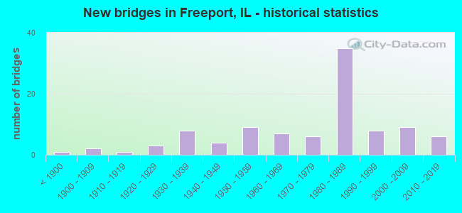
- New bridges - historical statistics
- 1Before 1900
- 21900-1909
- 11910-1919
- 31920-1929
- 81930-1939
- 41940-1949
- 91950-1959
- 71960-1969
- 61970-1979
- 351980-1989
- 81990-1999
- 92000-2009
- 62010-2019
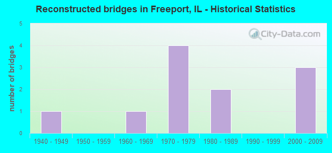
- Reconstructed bridges - Historical Statistics
- 11940-1949
- 01950-1959
- 11960-1969
- 41970-1979
- 21980-1989
- 01990-1999
- 32000-2009
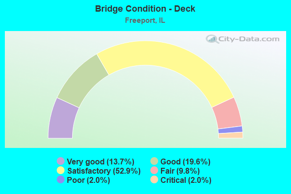
- Bridge Condition - Deck
- 13.7%Very good
- 19.6%Good
- 52.9%Satisfactory
- 9.8%Fair
- 2.0%Poor
- 2.0%Critical
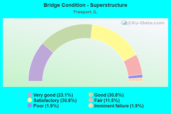
- Bridge Condition - Superstructure
- 23.1%Very good
- 30.8%Good
- 30.8%Satisfactory
- 11.5%Fair
- 1.9%Poor
- 1.9%Imminent failure
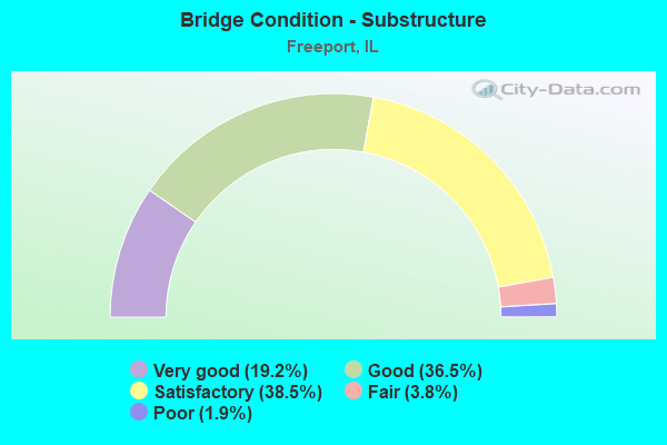
- Bridge Condition - Substructure
- 19.2%Very good
- 36.5%Good
- 38.5%Satisfactory
- 3.8%Fair
- 1.9%Poor
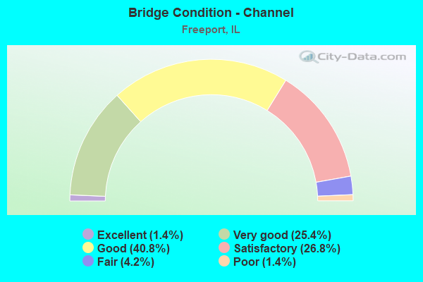
- Bridge Condition - Channel
- 1.4%Excellent
- 25.4%Very good
- 40.8%Good
- 26.8%Satisfactory
- 4.2%Fair
- 1.4%Poor
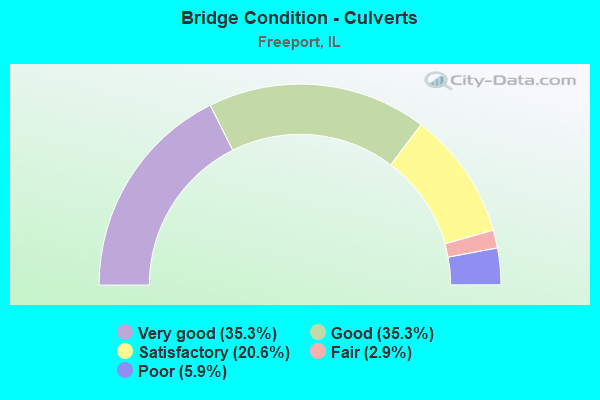
- Bridge Condition - Culverts
- 35.3%Very good
- 35.3%Good
- 20.6%Satisfactory
- 2.9%Fair
- 5.9%Poor
Find on map >> Show street view
Structure Number: 896001, Location: NORTHEAST FREEPORT (Lat: 42.297725, Lng: -89.605469), Route carried "on" structure: Other road , Year Built: 1952, Status: Open, Structure Length: 6.57m (21.56ft), Average Daily Traffic: 1,450 (year 2019), Truck Traffic: 12%, Average Future Daily Traffic: 1,600 (year 2040), Design Load: H 20, Features Intersected: PECATONICA RIVER, Facility Carried by Structure: HANCOCK AVENUE
Minimum Vertical Clearance: 30+ m (98+ ft), Kilometerpoint: 0.402, Lanes on structure: 2, Owner: City or Municipal Highway Agency, Approaching Roadway Width: 9.8m (32.2ft), Material/Design: Steel continuous, Design/Construction: Stringer/Multi-beam, Number Of Spans In Main Unit: 3, Length of Maximum Span: 25.3m (83.0ft), Curb or Sidewalk Widths: Left: 0.0m, Right: 1.2m (3.9ft), Curb-To-Curb Width: 7.3m (24.0ft), Out-to-Out Width: 9.4m (30.8ft)
Condition: Deck: Poor, Superstructure: Poor, Substructure: Good, Channel: Satisfactory, Operating Rating: 39.9 metric tons, Method Used To Determine Operating Rating: Load Factor (LF) rating reported by rating factor (RF) method using MS18 loading, Inventory Rating: 24.0 metric tons, Method Used To Determine Inventory Rating: Load Factor (LF) rating reported by rating factor (RF) method using MS18 loading, Structural Evaluation: Meets minimum limits, Deck Geometry: Meets minimum limits, Waterway Adequacy: Equal to present desirable criteria, Approach Roadway Alignment: Equal to present minimum criteria, Length Of Structure Improvement: 7.89m (25.89ft), Designated Inspection Frequency: Every 24 months, Inspection Date: June 2021, Bridge Improvement Cost: $589,000, Roadway Improvement Cost: $59,000, Total Project Cost: $884,000, Deck Structure Type: Concrete Cast-file-Place
Find on map >> Show street view
Structure Number: 896003, Location: AT KRAPE PARK (Lat: 42.277139, Lng: -89.646850), Route carried "on" structure: Other road , Year Built: 1920, Status: Closed, Structure Length: 1.89m (6.20ft), Average Daily Traffic: 25 (year 2014), Truck Traffic: 24%, Average Future Daily Traffic: 400 (year 2040), Features Intersected: YELLOW CREEK, Facility Carried by Structure: PARK COURT
Minimum Vertical Clearance: 30+ m (98+ ft), Kilometerpoint: 0.016, Lanes on structure: 1, Owner: City or Municipal Highway Agency, Approaching Roadway Width: 4.9m (16.1ft), Material/Design: Steel, Design/Construction: Truss - Thru, Number Of Spans In Main Unit: 1, Length of Maximum Span: 18.3m (60.0ft), Curb-To-Curb Width: 3.9m (12.8ft), Out-to-Out Width: 3.9m (12.8ft)
Condition: Deck: Critical, Superstructure: Imminent failure, Substructure: Poor, Channel: Satisfactory, Deck Geometry: Meets minimum limits, Waterway Adequacy: Equal to present minimum criteria, Approach Roadway Alignment: Equal to present minimum criteria, Bridge Posting: Required (Relationship of Operating Rating to Maximum Legal Load: > 39.9% below), Length Of Structure Improvement: 2.65m (8.69ft), Designated Inspection Frequency: Every 24 months, Critical Feature Inspection Frequency: Every 12 months, Inspection Date: June 2021, Critical Feature Inspection Date: December 2010, Bridge Improvement Cost: $70,000, Roadway Improvement Cost: $7,000, Total Project Cost: $105,000, Deck Structure Type: Concrete Cast-file-Place
Find on map >> Show street view
Structure Number: 897, Location: N. ENT TO KRAPE PARK (Lat: 42.278653, Lng: -89.652556), Route carried "on" structure: County highway , Year Built: 1919, Status: Open, Structure Length: 3.87m (12.70ft), Average Daily Traffic: 750 (year 2019), Truck Traffic: 6%, Average Future Daily Traffic: 600 (year 2040), Design Load: HS 15, Features Intersected: YELLOW CREEK, Facility Carried by Structure: N. PARK ROAD
Minimum Vertical Clearance: 30+ m (98+ ft), Kilometerpoint: 0.338, Lanes on structure: 2, Owner: Local Park, Forest, or Reservation Agency, Approaching Roadway Width: 6.1m (20.0ft), Material/Design: Concrete, Design/Construction: Tee Beam, Number Of Spans In Main Unit: 2, Length of Maximum Span: 18.9m (62.0ft), Curb or Sidewalk Widths: Left: 2.5m (8.2ft), Right: 2.5m (8.2ft), Curb-To-Curb Width: 6.2m (20.3ft), Out-to-Out Width: 11.3m (37.1ft)
Condition: Deck: Satisfactory, Superstructure: Satisfactory, Substructure: Satisfactory, Channel: Good, Operating Rating: 40.5 metric tons, Method Used To Determine Operating Rating: Field evaluation and documented engineering judgment, Inventory Rating: 24.3 metric tons, Method Used To Determine Inventory Rating: Field evaluation and documented engineering judgment, Structural Evaluation: Equal to present minimum criteria, Deck Geometry: High priority of corrective action, Waterway Adequacy: Equal to present desirable criteria, Approach Roadway Alignment: Equal to present minimum criteria, Length Of Structure Improvement: 4.63m (15.19ft), Designated Inspection Frequency: Every 24 months, Inspection Date: March 2020, Bridge Improvement Cost: $274,000, Roadway Improvement Cost: $27,000, Total Project Cost: $411,000, Deck Structure Type: Concrete Cast-file-Place, Wearing Surface/Protective System: Wearing Surface: Latex Concrete
Find on map >> Show street view
Structure Number: 897001, Location: S. ENT TO KRAPE PARK (Lat: 42.273208, Lng: -89.652558), Route carried "on" structure: County highway , Year Built: 1934, Status: Open, Structure Length: 2.44m (8.01ft), Average Daily Traffic: 125 (year 2019), Truck Traffic: 14%, Average Future Daily Traffic: 200 (year 2040), Design Load: HS 15, Features Intersected: YELLOW CREEK, Facility Carried by Structure: S. PARK ROAD
Minimum Vertical Clearance: 30+ m (98+ ft), Kilometerpoint: 0.048, Lanes on structure: 2, Owner: Local Park, Forest, or Reservation Agency, Approaching Roadway Width: 6.1m (20.0ft), Material/Design: Concrete, Design/Construction: Frame, Number Of Spans In Main Unit: 1, Length of Maximum Span: 22.3m (73.2ft), Curb or Sidewalk Widths: Left: 0.0m, Right: 1.5m (4.9ft), Curb-To-Curb Width: 6.0m (19.7ft), Out-to-Out Width: 7.9m (25.9ft)
Condition: Superstructure: Satisfactory, Substructure: Satisfactory, Channel: Good, Operating Rating: 63.8 metric tons, Method Used To Determine Operating Rating: Load Factor (LF) rating reported by rating factor (RF) method using MS18 loading, Inventory Rating: 38.2 metric tons, Method Used To Determine Inventory Rating: Load Factor (LF) rating reported by rating factor (RF) method using MS18 loading, Structural Evaluation: Equal to present minimum criteria, Deck Geometry: High priority of corrective action, Waterway Adequacy: Equal to present desirable criteria, Approach Roadway Alignment: Equal to present minimum criteria, Length Of Structure Improvement: 3.17m (10.40ft), Designated Inspection Frequency: Every 24 months, Inspection Date: March 2020, Bridge Improvement Cost: $139,000, Roadway Improvement Cost: $14,000, Total Project Cost: $209,000, Deck Structure Type: Concrete Cast-file-Place, Wearing Surface/Protective System: Wearing Surface: Other
Find on map >> Show street view
Structure Number: 890044, Location: 3 MI W OF IL 26 (Lat: 42.331328, Lng: -89.690714), Route carried "under" structure: US 20, Year Built: 1987, Structure Length: 0. m, Average Daily Traffic: 5,900 (year 2021), Truck Traffic: 23%, Features Intersected: US20 FREEPORT BYPASS, Facility Carried by Structure: HARLEM CENTER RD
Minimum Vertical Clearance: 4.93m (16.17ft), Kilometerpoint: 94.353, Lanes on structure: 2, Lanes under structure: 2, Material/Design: Steel continuous, Design/Construction: Stringer/Multi-beam, Length of Maximum Span: 40.8m (133.9ft)
Find on map >> Show street view
Structure Number: 890046, Location: 1 MI EAST IL 26 (Lat: 42.321000, Lng: -89.608000), Route carried "under" structure: US 20, Year Built: 1985, Structure Length: 0. m, Average Daily Traffic: 6,850 (year 2021), Truck Traffic: 20%, Features Intersected: US 20 FREEPORT BYPAS, Facility Carried by Structure: HENDERSON ROAD-TR2
Minimum Vertical Clearance: 5.00m (16.40ft), Kilometerpoint: 101.370, Lanes on structure: 2, Lanes under structure: 2, Material/Design: Prestressed concrete continuous, Design/Construction: Stringer/Multi-beam, Length of Maximum Span: 31.2m (102.4ft)
Find on map >> Show street view
Structure Number: 890047, Location: NE OF FREEPORT (Lat: 42.320994, Lng: -89.592700), Route carried "under" structure: US 20, Year Built: 2004, Structure Length: 0. m, Average Daily Traffic: 6,850 (year 2021), Truck Traffic: 20%, Features Intersected: US20 FREEPORT BYPASS, Facility Carried by Structure: TOWER ROAD
Minimum Vertical Clearance: 5.99m (19.65ft), Kilometerpoint: 102.545, Lanes on structure: 2, Lanes under structure: 4, Material/Design: Prestressed concrete continuous, Design/Construction: Stringer/Multi-beam, Length of Maximum Span: 36.1m (118.4ft)
Find on map >> Show street view
Structure Number: 890048, Location: NE OF FREEPORT (Lat: 42.312733, Lng: -89.572922), Route carried "under" structure: State highway 75, Year Built: 1986, Structure Length: 0. m, Average Daily Traffic: 2,550 (year 2021), Truck Traffic: 11%, Features Intersected: IL 75, Facility Carried by Structure: US 20 EB FREPRT BY
Minimum Vertical Clearance: 4.95m (16.24ft), Kilometerpoint: 6.180, Lanes on structure: 2, Lanes under structure: 2, Material/Design: Steel, Design/Construction: Stringer/Multi-beam, Length of Maximum Span: 41.5m (136.2ft)
Find on map >> Show street view
Structure Number: 890049, Location: 2 MI NE OF FREEPORT (Lat: 42.309061, Lng: -89.558981), Route carried "under" structure: US 20, Year Built: 1984, Structure Length: 0. m, Average Daily Traffic: 7,900 (year 2021), Truck Traffic: 23%, Features Intersected: US 20 FREEPORT BYPAS, Facility Carried by Structure: RIVER ROAD
Minimum Vertical Clearance: 5.21m (17.09ft), Kilometerpoint: 105.876, Lanes on structure: 2, Lanes under structure: 2, Material/Design: Prestressed concrete continuous, Design/Construction: Stringer/Multi-beam, Length of Maximum Span: 32.6m (107.0ft)
Find on map >> Show street view
Structure Number: 89005, Location: E OF FREEPORT (Lat: 42.279589, Lng: -89.542900), Route carried "under" structure: US 20, Year Built: 1986, Structure Length: 0. m, Average Daily Traffic: 7,050 (year 2021), Truck Traffic: 21%, Features Intersected: US20 FREEPORT BYPASS, Facility Carried by Structure: SPRINGFIELD RD
Minimum Vertical Clearance: 5.59m (18.34ft), Kilometerpoint: 109.754, Lanes on structure: 2, Lanes under structure: 4, Material/Design: Steel continuous, Design/Construction: Stringer/Multi-beam, Length of Maximum Span: 41.3m (135.5ft)
Find on map >> Show street view
Structure Number: 890056, Location: 1 MI N FREEPORT (Lat: 42.321436, Lng: -89.632600), Route carried "under" structure: State highway 26, Year Built: 1986, Structure Length: 0. m, Average Daily Traffic: 11,700 (year 2021), Truck Traffic: 4%, Features Intersected: ILL RT 26, Facility Carried by Structure: US 20 EB
Minimum Vertical Clearance: 5.49m (18.01ft), Kilometerpoint: 202.579, Lanes on structure: 2, Lanes under structure: 2, Material/Design: Prestressed concrete continuous, Design/Construction: Stringer/Multi-beam, Length of Maximum Span: 24.9m (81.7ft)
Find on map >> Show street view
Structure Number: 890057, Location: 1 MI N FREEPORT (Lat: 42.321747, Lng: -89.632606), Route carried "under" structure: State highway 26, Year Built: 1986, Structure Length: 0. m, Average Daily Traffic: 11,700 (year 2021), Truck Traffic: 4%, Features Intersected: ILL RT 26, Facility Carried by Structure: US 20 WB
Minimum Vertical Clearance: 5.03m (16.50ft), Kilometerpoint: 202.611, Lanes on structure: 2, Lanes under structure: 2, Material/Design: Prestressed concrete continuous, Design/Construction: Stringer/Multi-beam, Length of Maximum Span: 24.9m (81.7ft)
Find on map >> Show street view
Structure Number: 890061, Location: .3 MI E SPRINGFLD RD (Lat: 42.277058, Lng: -89.538781), Route carried "under" structure: US 20, Year Built: 1987, Structure Length: 0. m, Average Daily Traffic: 7,050 (year 2021), Truck Traffic: 21%, Features Intersected: US20 FREEPORT BYPASS
Minimum Vertical Clearance: 5.18m (16.99ft), Kilometerpoint: 110.414, Lanes on structure: 1, Lanes under structure: 4, Material/Design: Steel continuous, Design/Construction: Stringer/Multi-beam, Length of Maximum Span: 39.6m (129.9ft)
Find on map >> Show street view
Structure Number: 89008, Location: NE OF FREEPORT (Lat: 42.312469, Lng: -89.572917), Route carried "under" structure: State highway 75, Year Built: 2004, Structure Length: 0. m, Average Daily Traffic: 1,900 (year 2021), Truck Traffic: 18%, Features Intersected: IL RT 75, Facility Carried by Structure: US20WB FREEPORT BY
Minimum Vertical Clearance: 5.16m (16.93ft), Kilometerpoint: 6.148, Lanes on structure: 2, Lanes under structure: 2, Material/Design: Steel, Design/Construction: Stringer/Multi-beam, Length of Maximum Span: 39.8m (130.6ft)
Find on map >> Show street view
Structure Number: 8999, Location: 2 MI W FREEPORT (Lat: 42.318731, Lng: -89.678589), Route carried "under" structure: Business US 20, Year Built: 1935, Structure Length: 0. m, Average Daily Traffic: 2,700 (year 2021), Truck Traffic: 3%, Features Intersected: US 20 BR, Facility Carried by Structure: CN RR
Minimum Vertical Clearance: 5.13m (16.83ft), Kilometerpoint: 3.380, Lanes under structure: 2, Material/Design: Steel, Design/Construction: Girder and Floorbeam System, Length of Maximum Span: 10.1m (33.1ft)
Find on map >> Show street view
Structure Number: 899907, Location: .2 MI S. OF US 20 (Lat: 42.326156, Lng: -89.719781), Route carried "under" structure: County highway , Year Built: 1901, Structure Length: 0. m, Average Daily Traffic: 900 (year 2019), Truck Traffic: 3%, Features Intersected: BOLTON RD (FAS78), Facility Carried by Structure: CN RAILRAOD
Minimum Vertical Clearance: 3.66m (12.01ft), Kilometerpoint: 0.338, Lanes under structure: 2, Material/Design: Steel, Design/Construction: Stringer/Multi-beam, Length of Maximum Span: 7.3m (24.0ft)
Find on map >> Show street view
Structure Number: 899915, Location: I MI E OF FREEPORT (Lat: 42.276900, Lng: -89.572925), Route carried "under" structure: County highway , Year Built: 1922, Structure Length: 0. m, Average Daily Traffic: 100 (year 2019), Truck Traffic: 57%, Features Intersected: YELLOW CREEK RD, Facility Carried by Structure: CN RR
Minimum Vertical Clearance: 3.71m (12.17ft), Kilometerpoint: 0.885, Lanes under structure: 2, Material/Design: Steel, Design/Construction: Girder and Floorbeam System, Length of Maximum Span: 14.8m (48.6ft)