Bridge Statistics for Frisco, Texas (TX)
Condition, Traffic, Stress, Structural Evaluation, Project Costs
- National Bridge Inventory (NBI) Statistics
- 229Number of bridges
- 4,665ft / 1,422mTotal length
- $165,000Total costs
- 3,696,176Total average daily traffic
- 122,007Total average daily truck traffic
- National Bridge Inventory (NBI) Registered Bridges for Frisco
- No street view available for this location
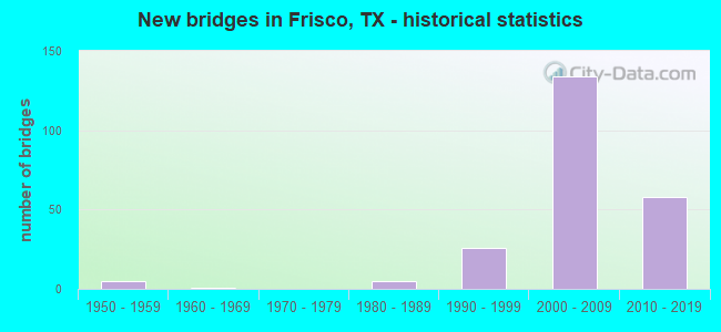
- New bridges - historical statistics
- 51950-1959
- 11960-1969
- 51980-1989
- 261990-1999
- 1342000-2009
- 582010-2019

- Reconstructed bridges - Historical Statistics
- 192000-2009
- 82010-2019
- 42020-2022


- Bridge Condition - Deck
- 9.3%Very good
- 88.7%Good
- 2.1%Satisfactory

- Bridge Condition - Superstructure
- 2.1%Excellent
- 38.1%Very good
- 51.5%Good
- 8.2%Satisfactory

- Bridge Condition - Substructure
- 3.1%Very good
- 78.4%Good
- 15.5%Satisfactory
- 3.1%Fair

- Bridge Condition - Channel
- 12.2%Very good
- 54.0%Good
- 30.2%Satisfactory
- 2.9%Fair
- 0.7%Poor

- Bridge Condition - Culverts
- 3.6%Very good
- 79.8%Good
- 16.7%Satisfactory
Find on map >> Show street view
Structure Number: 180430009104071, Location: 0.4 MI S OF US 380 (Lat: 33.214656, Lng: -96.802814), Route carried "on" structure: State highway 289, Year Built: 2005, Year Reconstructed: 2011, Status: Open, Structure Length: 2.41m (7.91ft), Average Daily Traffic: 35,557 (year 2019), Truck Traffic: 1%, Average Future Daily Traffic: 54,670 (year 2038), Design Load: HS 20, Features Intersected: PARVIN BRANCH
Minimum Vertical Clearance: 30+ m (98+ ft), Kilometerpoint: 23.223, Lanes on structure: 6, Base Highway Network: Yes, Owner: State Highway Agency, Approaching Roadway Width: 24.4m (80.1ft), Skew: 20 degrees, Material/Design: Prestressed concrete, Design/Construction: Stringer/Multi-beam, Number Of Spans In Main Unit: 1, Length of Maximum Span: 23.8m (78.1ft), Curb or Sidewalk Widths: Left: 2.0m (6.6ft), Right: 2.0m (6.6ft), Curb-To-Curb Width: 24.4m (80.1ft), Out-to-Out Width: 33.6m (110.2ft)
Condition: Deck: Good, Superstructure: Very good, Substructure: Satisfactory, Channel: Good, Operating Rating: 54.4 metric tons, Method Used To Determine Operating Rating: Assigned rating based on Load Factor Design (LFD) reported in metric tons, Inventory Rating: 32.7 metric tons, Method Used To Determine Inventory Rating: Assigned rating based on Load Factor Design (LFD) reported in metric tons, Structural Evaluation: Equal to present minimum criteria, Deck Geometry: Somewhat better than minimum adequacy, Waterway Adequacy: Superior to present desirable criteria, Approach Roadway Alignment: Equal to present desirable criteria, Designated Inspection Frequency: Every 24 months, Inspection Date: October 2021, Deck Structure Type: Concrete Cast-file-Place, Wearing Surface/Protective System: Wearing Surface: Monolithic Concrete
Find on map >> Show street view
Structure Number: 180430009104072, Location: 2.95 MI S OF US 380 (Lat: 33.176153, Lng: -96.803092), Route carried "on" structure: State highway 289, Year Built: 2005, Year Reconstructed: 2010, Status: Open, Structure Length: 3.57m (11.71ft), Average Daily Traffic: 35,557 (year 2019), Truck Traffic: 1%, Average Future Daily Traffic: 31,888 (year 2040), Design Load: HS 20, Features Intersected: PANTHER CREEK
Minimum Vertical Clearance: 30+ m (98+ ft), Kilometerpoint: 27.523, Lanes on structure: 6, Owner: State Highway Agency, Approaching Roadway Width: 23.2m (76.1ft), Skew: 23 degrees, Material/Design: Prestressed concrete, Design/Construction: Stringer/Multi-beam, Number Of Spans In Main Unit: 1, Length of Maximum Span: 35.7m (117.1ft), Curb or Sidewalk Widths: Left: 2.0m (6.6ft), Right: 2.0m (6.6ft), Curb-To-Curb Width: 23.2m (76.1ft), Out-to-Out Width: 36.9m (121.1ft)
Condition: Deck: Satisfactory, Superstructure: Satisfactory, Substructure: Satisfactory, Channel: Satisfactory, Operating Rating: 54.4 metric tons, Method Used To Determine Operating Rating: Assigned rating based on Load Factor Design (LFD) reported in metric tons, Inventory Rating: 32.7 metric tons, Method Used To Determine Inventory Rating: Assigned rating based on Load Factor Design (LFD) reported in metric tons, Structural Evaluation: Equal to present minimum criteria, Deck Geometry: Meets minimum limits, Waterway Adequacy: Superior to present desirable criteria, Approach Roadway Alignment: Equal to present desirable criteria, Designated Inspection Frequency: Every 24 months, Inspection Date: November 2021, Deck Structure Type: Concrete Cast-file-Place
Find on map >> Show street view
Structure Number: 180430009104073, Location: 2.75 MI S OF US 380 (Lat: 33.178925, Lng: -96.803078), Route carried "on" structure: State highway 289, Year Built: 2005, Year Reconstructed: 2010, Status: Open, Structure Length: 3.57m (11.71ft), Average Daily Traffic: 35,557 (year 2019), Truck Traffic: 1%, Average Future Daily Traffic: 31,888 (year 2040), Design Load: HS 20, Features Intersected: PANTHER CREEK RELIEF
Minimum Vertical Clearance: 30+ m (98+ ft), Kilometerpoint: 27.198, Lanes on structure: 6, Owner: State Highway Agency, Approaching Roadway Width: 23.2m (76.1ft), Skew: 23 degrees, Material/Design: Prestressed concrete, Design/Construction: Stringer/Multi-beam, Number Of Spans In Main Unit: 1, Length of Maximum Span: 35.7m (117.1ft), Curb or Sidewalk Widths: Left: 2.0m (6.6ft), Right: 2.0m (6.6ft), Curb-To-Curb Width: 23.2m (76.1ft), Out-to-Out Width: 33.6m (110.2ft)
Condition: Deck: Good, Superstructure: Good, Substructure: Satisfactory, Channel: Poor, Operating Rating: 54.4 metric tons, Method Used To Determine Operating Rating: Assigned rating based on Load Factor Design (LFD) reported in metric tons, Inventory Rating: 32.7 metric tons, Method Used To Determine Inventory Rating: Assigned rating based on Load Factor Design (LFD) reported in metric tons, Structural Evaluation: Equal to present minimum criteria, Deck Geometry: Meets minimum limits, Waterway Adequacy: Superior to present desirable criteria, Approach Roadway Alignment: Equal to present desirable criteria, Designated Inspection Frequency: Every 24 months, Inspection Date: November 2021, Deck Structure Type: Concrete Cast-file-Place
Find on map >> Show street view
Structure Number: 180430009105066, Location: 0.5 MI S OF FM 3537 (Lat: 33.145572, Lng: -96.804858), Route carried "on" structure: State highway 289, Year Built: 1955, Year Reconstructed: 2000, Status: Open, Structure Length: 0.82m (2.69ft), Average Daily Traffic: 22,081 (year 2020), Truck Traffic: 1%, Average Future Daily Traffic: 61,477 (year 2040), Features Intersected: DRAW
Minimum Vertical Clearance: 30+ m (98+ ft), Kilometerpoint: 32.229, Lanes on structure: 7, Owner: State Highway Agency, Approaching Roadway Width: 24.4m (80.1ft), Skew: 21 degrees, Material/Design: Concrete, Design/Construction: Culvert, Number Of Spans In Main Unit: 3, Length of Maximum Span: 2.1m (6.9ft), Curb or Sidewalk Widths: Left: 1.8m (5.9ft), Right: 0.0m
Condition: Channel: Good, Culverts: Satisfactory, Operating Rating: 32.7 metric tons, Method Used To Determine Operating Rating: No rating analysis performed, Inventory Rating: 24.5 metric tons, Method Used To Determine Inventory Rating: No rating analysis performed, Structural Evaluation: Equal to present minimum criteria, Waterway Adequacy: Equal to present minimum criteria, Approach Roadway Alignment: Equal to present desirable criteria, Designated Inspection Frequency: Every 24 months, Inspection Date: November 2021
Find on map >> Show street view
Structure Number: 180430009105067, Location: 1.3 MI S OF FM 3537 (Lat: 33.133547, Lng: -96.804500), Route carried "on" structure: State highway 289, Year Built: 1955, Year Reconstructed: 2015, Status: Open, Structure Length: 0.67m (2.20ft), Average Daily Traffic: 22,081 (year 2020), Truck Traffic: 2%, Average Future Daily Traffic: 44,162 (year 2040), Features Intersected: STEWART CREEK
Minimum Vertical Clearance: 30+ m (98+ ft), Kilometerpoint: 33.555, Lanes on structure: 9, Owner: State Highway Agency, Approaching Roadway Width: 40.2m (131.9ft), Skew: 20 degrees, Material/Design: Concrete, Design/Construction: Culvert, Number Of Spans In Main Unit: 2, Length of Maximum Span: 3.0m (9.8ft), Curb or Sidewalk Widths: Left: 1.7m (5.6ft), Right: 2.0m (6.6ft)
Condition: Channel: Good, Culverts: Satisfactory, Operating Rating: 32.7 metric tons, Method Used To Determine Operating Rating: No rating analysis performed, Inventory Rating: 24.5 metric tons, Method Used To Determine Inventory Rating: No rating analysis performed, Structural Evaluation: Equal to present minimum criteria, Waterway Adequacy: Equal to present minimum criteria, Approach Roadway Alignment: Equal to present desirable criteria, Designated Inspection Frequency: Every 24 months, Inspection Date: November 2021
Find on map >> Show street view
Structure Number: 180430009105068, Location: 1.6 MI S OF FM 3537 (Lat: 33.129531, Lng: -96.805072), Route carried "on" structure: State highway 289, Year Built: 1955, Year Reconstructed: 2000, Status: Open, Structure Length: 1.62m (5.31ft), Average Daily Traffic: 22,081 (year 2020), Truck Traffic: 2%, Average Future Daily Traffic: 44,162 (year 2040), Features Intersected: WADE CREEK
Minimum Vertical Clearance: 30+ m (98+ ft), Kilometerpoint: 34.018, Lanes on structure: 7, Owner: State Highway Agency, Approaching Roadway Width: 23.2m (76.1ft), Skew: 24 degrees, Material/Design: Concrete, Design/Construction: Culvert, Number Of Spans In Main Unit: 4, Length of Maximum Span: 2.7m (8.9ft), Curb or Sidewalk Widths: Left: 1.5m (4.9ft), Right: 0.0m
Condition: Channel: Good, Culverts: Satisfactory, Operating Rating: 32.7 metric tons, Method Used To Determine Operating Rating: No rating analysis performed, Inventory Rating: 24.5 metric tons, Method Used To Determine Inventory Rating: No rating analysis performed, Structural Evaluation: Equal to present minimum criteria, Waterway Adequacy: Equal to present minimum criteria, Approach Roadway Alignment: Equal to present desirable criteria, Designated Inspection Frequency: Every 24 months, Inspection Date: November 2021
Find on map >> Show street view
Structure Number: 18043000950434, Location: 1 MI S OF US 380 (Lat: 33.186667, Lng: -96.802778), Route carried "on" structure: State highway 289, Year Built: 2013, Year Reconstructed: 2021, Status: Open, Structure Length: 0.76m (2.49ft), Average Daily Traffic: 35,557 (year 2019), Truck Traffic: 1%, Average Future Daily Traffic: 31,888 (year 2040), Design Load: HS 20, Features Intersected: SH 289, Facility Carried by Structure: DRAW
Minimum Vertical Clearance: 30+ m (98+ ft), Kilometerpoint: 160.933, Lanes on structure: 7, Owner: State Highway Agency, Approaching Roadway Width: 27.2m (89.2ft), Skew: 24 degrees, Material/Design: Concrete, Design/Construction: Culvert, Number Of Spans In Main Unit: 3, Length of Maximum Span: 1.5m (4.9ft), Curb or Sidewalk Widths: Left: 1.8m (5.9ft), Right: 0.0m
Condition: Channel: Satisfactory, Culverts: Satisfactory, Operating Rating: 54.4 metric tons, Method Used To Determine Operating Rating: Assigned rating based on Load Factor Design (LFD) reported in metric tons, Inventory Rating: 32.7 metric tons, Method Used To Determine Inventory Rating: Assigned rating based on Load Factor Design (LFD) reported in metric tons, Structural Evaluation: Equal to present minimum criteria, Waterway Adequacy: Equal to present desirable criteria, Approach Roadway Alignment: Equal to present desirable criteria, Designated Inspection Frequency: Every 24 months, Inspection Date: November 2021
Find on map >> Show street view
Structure Number: 180430013511244, Location: 0.55 MI W of SH 289 (Lat: 33.219100, Lng: -96.821300), Route carried "on" structure: US 380, Year Built: 2017, Status: Open, Structure Length: 12.80m (41.99ft), Average Daily Traffic: 29,549 (year 2017), Truck Traffic: 10%, Average Future Daily Traffic: 41,370 (year 2037), Design Load: HL 93, Features Intersected: BNSF RAILROAD
Minimum Vertical Clearance: 30+ m (98+ ft), Kilometerpoint: 2.501, Lanes on structure: 4, Lanes under structure: 2, Base Highway Network: Yes, Owner: State Highway Agency, Approaching Roadway Width: 12.2m (40.0ft), Skew: 21 degrees, Material/Design: Prestressed concrete, Design/Construction: Stringer/Multi-beam, Number Of Spans In Main Unit: 3, Length of Maximum Span: 45.7m (149.9ft), Curb-To-Curb Width: 15.7m (51.5ft), Out-to-Out Width: 18.6m (61.0ft)
Condition: Deck: Good, Superstructure: Very good, Substructure: Good, Operating Rating: 54.4 metric tons, Method Used To Determine Operating Rating: Assigned ratings based on Load and Resistance Factor Design (LRFD) reported in metric tons, Inventory Rating: 32.7 metric tons, Method Used To Determine Inventory Rating: Assigned ratings based on Load and Resistance Factor Design (LRFD) reported in metric tons, Structural Evaluation: Better than present minimum criteria, Deck Geometry: Meets minimum limits, Underclear: Superior to present desirable criteria, Approach Roadway Alignment: Equal to present desirable criteria, Designated Inspection Frequency: Every 24 months, Inspection Date: October 2021, Deck Structure Type: Concrete Cast-file-Place, Wearing Surface/Protective System: Deck Protection: Epoxy Coated Reinforcing
Find on map >> Show street view
Structure Number: 180430013511245, Location: 0.5 mi W of SH 289 (Lat: 33.218911, Lng: -96.821300), Route carried "on" structure: US 380, Year Built: 2019, Status: Open, Structure Length: 12.80m (41.99ft), Average Daily Traffic: 26,200 (year 2008), Truck Traffic: 7%, Average Future Daily Traffic: 45,600 (year 2030), Design Load: HL 93, Features Intersected: BNSF Railroad
Minimum Vertical Clearance: 30+ m (98+ ft), Kilometerpoint: 2.501, Lanes on structure: 4, Base Highway Network: Yes, Owner: State Highway Agency, Approaching Roadway Width: 15.5m (50.9ft), Skew: 1 degrees, Material/Design: Prestressed concrete, Design/Construction: Stringer/Multi-beam, Number Of Spans In Main Unit: 3, Length of Maximum Span: 45.7m (149.9ft), Curb-To-Curb Width: 15.7m (51.5ft), Out-to-Out Width: 18.6m (61.0ft)
Condition: Deck: Good, Superstructure: Good, Substructure: Good, Operating Rating: 54.4 metric tons, Method Used To Determine Operating Rating: Assigned ratings based on Load and Resistance Factor Design (LRFD) reported in metric tons, Inventory Rating: 32.7 metric tons, Method Used To Determine Inventory Rating: Assigned ratings based on Load and Resistance Factor Design (LRFD) reported in metric tons, Structural Evaluation: Better than present minimum criteria, Deck Geometry: Meets minimum limits, Underclear: Superior to present desirable criteria, Approach Roadway Alignment: Equal to present desirable criteria, Designated Inspection Frequency: Every 24 months, Inspection Date: March 2021, Deck Structure Type: Concrete Precast Panels
Find on map >> Show street view
Structure Number: 180430013511246, Location: US 380 AT SH 289 (Lat: 33.218772, Lng: -96.803539), Route carried "on" structure: US 380, Year Built: 2019, Status: Open, Structure Length: 47.24m (154.99ft), Average Daily Traffic: 26,200 (year 2008), Truck Traffic: 5%, Average Future Daily Traffic: 45,600 (year 2030), Design Load: HL 93, Features Intersected: SH 289
Minimum Vertical Clearance: 5.16m (16.93ft), Kilometerpoint: 0.000, Lanes on structure: 6, Lanes under structure: 14, Base Highway Network: Yes, Owner: State Highway Agency, Approaching Roadway Width: 24.4m (80.1ft), Skew: 22 degrees, Material/Design: Prestressed concrete, Design/Construction: Stringer/Multi-beam, Number Of Spans In Main Unit: 11, Length of Maximum Span: 45.7m (149.9ft), Curb-To-Curb Width: 24.4m (80.1ft), Out-to-Out Width: 29.9m (98.1ft)
Condition: Deck: Good, Superstructure: Good, Substructure: Good, Operating Rating: 54.4 metric tons, Method Used To Determine Operating Rating: Assigned ratings based on Load and Resistance Factor Design (LRFD) reported in metric tons, Inventory Rating: 32.7 metric tons, Method Used To Determine Inventory Rating: Assigned ratings based on Load and Resistance Factor Design (LRFD) reported in metric tons, Structural Evaluation: Better than present minimum criteria, Deck Geometry: Somewhat better than minimum adequacy, Underclear: Superior to present desirable criteria, Approach Roadway Alignment: Equal to present desirable criteria, Designated Inspection Frequency: Every 24 months, Inspection Date: January 2021, Deck Structure Type: Concrete Precast Panels
Find on map >> Show street view
Structure Number: 180430013512084, Location: 1.95 MI E OF SH 289 (Lat: 33.152533, Lng: -96.769639), Route carried "on" structure: State highway 3537, Year Built: 1954, Year Reconstructed: 2014, Status: Open, Structure Length: 0.76m (2.49ft), Average Daily Traffic: 21,479 (year 2020), Truck Traffic: 3%, Average Future Daily Traffic: 30,615 (year 2040), Features Intersected: WEST ROWLETT CREEK
Minimum Vertical Clearance: 30+ m (98+ ft), Kilometerpoint: 19.248, Lanes on structure: 6, Owner: State Highway Agency, Approaching Roadway Width: 21.9m (71.9ft), Skew: 3 degrees, Material/Design: Concrete, Design/Construction: Culvert, Number Of Spans In Main Unit: 2, Length of Maximum Span: 3.0m (9.8ft)
Condition: Channel: Good, Culverts: Good, Operating Rating: 32.7 metric tons, Method Used To Determine Operating Rating: No rating analysis performed, Inventory Rating: 24.5 metric tons, Method Used To Determine Inventory Rating: No rating analysis performed, Structural Evaluation: Equal to present minimum criteria, Waterway Adequacy: Superior to present desirable criteria, Approach Roadway Alignment: Equal to present desirable criteria, Designated Inspection Frequency: Every 24 months, Inspection Date: November 2021
Find on map >> Show street view
Structure Number: 180430036404123, Location: DNT/SH 121 INTERCHANGE (Lat: 33.090942, Lng: -96.823703), Route carried "on" structure: Other road 121, Year Built: 2009, Status: Open, Structure Length: 15.67m (51.41ft), Average Daily Traffic: 55,316 (year 2018), Truck Traffic: 5%, Average Future Daily Traffic: 77,443 (year 2038), Design Load: HS 20, Features Intersected: DNT FRONTAGE ROADS
Minimum Vertical Clearance: 5.28m (17.32ft), Kilometerpoint: 36.271, Lanes on structure: 4, Lanes under structure: 8, Base Highway Network: Yes, Toll: On toll road, Owner: Local Toll Authority, Approaching Roadway Width: 17.7m (58.1ft), Skew: 1 degrees, Material/Design: Prestressed concrete, Design/Construction: Stringer/Multi-beam, Number Of Spans In Main Unit: 5, Length of Maximum Span: 36.0m (118.1ft), Curb-To-Curb Width: 20.0m (65.6ft), Out-to-Out Width: 20.8m (68.2ft)
Condition: Deck: Good, Superstructure: Good, Substructure: Good, Operating Rating: 54.4 metric tons, Method Used To Determine Operating Rating: Assigned rating based on Load Factor Design (LFD) reported in metric tons, Inventory Rating: 32.7 metric tons, Method Used To Determine Inventory Rating: Assigned rating based on Load Factor Design (LFD) reported in metric tons, Structural Evaluation: Better than present minimum criteria, Deck Geometry: Equal to present minimum criteria, Underclear: Meets minimum limits, Approach Roadway Alignment: Equal to present desirable criteria, Designated Inspection Frequency: Every 24 months, Inspection Date: November 2021, Deck Structure Type: Concrete Cast-file-Place, Wearing Surface/Protective System: Wearing Surface: Monolithic Concrete
Find on map >> Show street view
Structure Number: 180430036404132, Location: 0.1 MI W OF FM 2478 (Lat: 33.124422, Lng: -96.736575), Route carried "on" structure: ServiceState highway 121, Year Built: 2005, Status: Open, Structure Length: 10.06m (33.01ft), Average Daily Traffic: 16,761 (year 2020), Truck Traffic: 5%, Average Future Daily Traffic: 23,465 (year 2040), Design Load: HS 20, Features Intersected: W ROWLETT CREEK
Minimum Vertical Clearance: 30+ m (98+ ft), Kilometerpoint: 27.431, Lanes on structure: 3, Owner: Local Toll Authority, Approaching Roadway Width: 12.2m (40.0ft), Skew: 4 degrees, Material/Design: Prestressed concrete, Design/Construction: Stringer/Multi-beam, Number Of Spans In Main Unit: 3, Length of Maximum Span: 33.5m (109.9ft), Curb or Sidewalk Widths: Left: 2.4m (7.9ft), Right: 0.0m, Curb-To-Curb Width: 12.2m (40.0ft), Out-to-Out Width: 15.5m (50.9ft)
Condition: Deck: Good, Superstructure: Very good, Substructure: Satisfactory, Channel: Satisfactory, Operating Rating: 54.4 metric tons, Method Used To Determine Operating Rating: Assigned rating based on Load Factor Design (LFD) reported in metric tons, Inventory Rating: 32.7 metric tons, Method Used To Determine Inventory Rating: Assigned rating based on Load Factor Design (LFD) reported in metric tons, Structural Evaluation: Equal to present minimum criteria, Deck Geometry: Meets minimum limits, Waterway Adequacy: Superior to present desirable criteria, Approach Roadway Alignment: Equal to present desirable criteria, Designated Inspection Frequency: Every 24 months, Inspection Date: October 2021, Deck Structure Type: Concrete Precast Panels
Find on map >> Show street view
Structure Number: 180430036404136, Location: 5.5 MI W OF US 75 (Lat: 33.125247, Lng: -96.733353), Route carried "on" structure: Other road 121, Year Built: 2005, Year Reconstructed: 2008, Status: Open, Structure Length: 9.78m (32.09ft), Average Daily Traffic: 55,624 (year 2020), Truck Traffic: 9%, Average Future Daily Traffic: 38,934 (year 2040), Design Load: HS 20, Features Intersected: CUSTER RD (FM 2478)
Minimum Vertical Clearance: 30+ m (98+ ft), Kilometerpoint: 27.127, Lanes on structure: 3, Lanes under structure: 10, Toll: On toll road, Owner: Local Toll Authority, Approaching Roadway Width: 17.7m (58.1ft), Material/Design: Prestressed concrete, Design/Construction: Stringer/Multi-beam, Number Of Spans In Main Unit: 3, Length of Maximum Span: 36.9m (121.1ft), Curb-To-Curb Width: 20.7m (67.9ft), Out-to-Out Width: 21.3m (69.9ft)
Condition: Deck: Good, Superstructure: Good, Substructure: Good, Operating Rating: 54.4 metric tons, Method Used To Determine Operating Rating: Assigned rating based on Load Factor Design (LFD) reported in metric tons, Inventory Rating: 32.7 metric tons, Method Used To Determine Inventory Rating: Assigned rating based on Load Factor Design (LFD) reported in metric tons, Structural Evaluation: Better than present minimum criteria, Deck Geometry: Superior to present desirable criteria, Underclear: Meets minimum limits, Approach Roadway Alignment: Equal to present desirable criteria, Designated Inspection Frequency: Every 24 months, Inspection Date: October 2021, Deck Structure Type: Concrete Precast Panels
Find on map >> Show street view
Structure Number: 180430036404142, Location: 0.1 MI W OF CUSTER RD (Lat: 33.125297, Lng: -96.734522), Route carried "on" structure: ServiceState highway 121, Year Built: 2005, Year Reconstructed: 2016, Status: Open, Structure Length: 1.95m (6.40ft), Average Daily Traffic: 16,761 (year 2020), Truck Traffic: 5%, Average Future Daily Traffic: 23,465 (year 2038), Design Load: HS 20, Features Intersected: BR OF WEST ROWLETT CREEK
Minimum Vertical Clearance: 30+ m (98+ ft), Kilometerpoint: 27.335, Lanes on structure: 4, Owner: Local Toll Authority, Approaching Roadway Width: 12.2m (40.0ft), Skew: 5 degrees, Material/Design: Concrete, Design/Construction: Culvert, Number Of Spans In Main Unit: 4, Length of Maximum Span: 2.7m (8.9ft)
Condition: Channel: Satisfactory, Culverts: Satisfactory, Operating Rating: 54.4 metric tons, Method Used To Determine Operating Rating: Assigned rating based on Load Factor Design (LFD) reported in metric tons, Inventory Rating: 32.7 metric tons, Method Used To Determine Inventory Rating: Assigned rating based on Load Factor Design (LFD) reported in metric tons, Structural Evaluation: Equal to present minimum criteria, Waterway Adequacy: Superior to present desirable criteria, Approach Roadway Alignment: Equal to present desirable criteria, Designated Inspection Frequency: Every 24 months, Inspection Date: October 2021
Find on map >> Show street view
Structure Number: 180430036404164, Location: 0.5 MI NE OF DNT (Lat: 33.093275, Lng: -96.815231), Route carried "on" structure: Other road 121, Year Built: 2008, Status: Open, Structure Length: 9.94m (32.61ft), Average Daily Traffic: 105,520 (year 2020), Truck Traffic: 5%, Average Future Daily Traffic: 154,885 (year 2038), Design Load: HS 20, Features Intersected: PARKWOOD BOULEVARD, Facility Carried by Structure: SRT SBML
Minimum Vertical Clearance: 30+ m (98+ ft), Kilometerpoint: 35.512, Lanes on structure: 3, Lanes under structure: 9, Base Highway Network: Yes, Toll: On toll road, Owner: Local Toll Authority, Approaching Roadway Width: 17.7m (58.1ft), Material/Design: Prestressed concrete, Design/Construction: Stringer/Multi-beam, Number Of Spans In Main Unit: 3, Length of Maximum Span: 36.6m (120.1ft), Curb-To-Curb Width: 15.2m (49.9ft), Out-to-Out Width: 18.3m (60.0ft)
Condition: Deck: Good, Superstructure: Good, Substructure: Good, Operating Rating: 54.4 metric tons, Method Used To Determine Operating Rating: Assigned rating based on Load Factor Design (LFD) reported in metric tons, Inventory Rating: 32.7 metric tons, Method Used To Determine Inventory Rating: Assigned rating based on Load Factor Design (LFD) reported in metric tons, Structural Evaluation: Better than present minimum criteria, Deck Geometry: Equal to present minimum criteria, Underclear: Meets minimum limits, Approach Roadway Alignment: Equal to present desirable criteria, Designated Inspection Frequency: Every 24 months, Inspection Date: November 2021, Deck Structure Type: Concrete Cast-file-Place
Find on map >> Show street view
Structure Number: 180430036404167, Location: AT SH 289 (PRESTON) INT (Lat: 33.096567, Lng: -96.807036), Route carried "on" structure: Other road 121, Year Built: 2008, Year Reconstructed: 2020, Status: Open, Structure Length: 29.26m (96.00ft), Average Daily Traffic: 55,316 (year 2018), Truck Traffic: 5%, Average Future Daily Traffic: 77,443 (year 2038), Design Load: HS 20, Features Intersected: SH 289, Facility Carried by Structure: SRT SBML
Minimum Vertical Clearance: 30+ m (98+ ft), Kilometerpoint: 34.736, Lanes on structure: 5, Lanes under structure: 10, Base Highway Network: Yes, Toll: On toll road, Owner: Local Toll Authority, Approaching Roadway Width: 24.4m (80.1ft), Skew: 2 degrees, Material/Design: Prestressed concrete, Design/Construction: Stringer/Multi-beam, Number Of Spans In Main Unit: 9, Length of Maximum Span: 33.5m (109.9ft), Curb-To-Curb Width: 24.4m (80.1ft), Out-to-Out Width: 25.0m (82.0ft)
Condition: Deck: Good, Superstructure: Good, Substructure: Good, Operating Rating: 54.4 metric tons, Method Used To Determine Operating Rating: Assigned rating based on Load Factor Design (LFD) reported in metric tons, Inventory Rating: 32.7 metric tons, Method Used To Determine Inventory Rating: Assigned rating based on Load Factor Design (LFD) reported in metric tons, Structural Evaluation: Better than present minimum criteria, Deck Geometry: Equal to present minimum criteria, Underclear: High priority of corrective action, Approach Roadway Alignment: Equal to present desirable criteria, Designated Inspection Frequency: Every 24 months, Inspection Date: November 2021, Deck Structure Type: Concrete Cast-file-Place
Find on map >> Show street view
Structure Number: 18043003640417, Location: 1.4 MI NE OF SH 289 (Lat: 33.106114, Lng: -96.784325), Route carried "on" structure: ServiceState highway 121, Year Built: 2008, Status: Open, Structure Length: 16.76m (54.99ft), Average Daily Traffic: 20,544 (year 2019), Truck Traffic: 3%, Average Future Daily Traffic: 29,320 (year 2038), Design Load: HS 20, Features Intersected: WHITE ROCK CREEK
Minimum Vertical Clearance: 30+ m (98+ ft), Kilometerpoint: 32.441, Lanes on structure: 3, Owner: Local Toll Authority, Approaching Roadway Width: 12.2m (40.0ft), Skew: 4 degrees, Material/Design: Prestressed concrete, Design/Construction: Stringer/Multi-beam, Number Of Spans In Main Unit: 5, Length of Maximum Span: 38.1m (125.0ft), Curb or Sidewalk Widths: Left: 2.5m (8.2ft), Right: 0.0m, Curb-To-Curb Width: 12.1m (39.7ft), Out-to-Out Width: 15.5m (50.9ft)
Condition: Deck: Good, Superstructure: Good, Substructure: Good, Channel: Fair, Operating Rating: 54.4 metric tons, Method Used To Determine Operating Rating: Assigned rating based on Load Factor Design (LFD) reported in metric tons, Inventory Rating: 32.7 metric tons, Method Used To Determine Inventory Rating: Assigned rating based on Load Factor Design (LFD) reported in metric tons, Structural Evaluation: Better than present minimum criteria, Deck Geometry: Meets minimum limits, Waterway Adequacy: Superior to present desirable criteria, Approach Roadway Alignment: Equal to present desirable criteria, Length Of Structure Improvement: 16.76m (54.99ft), Designated Inspection Frequency: Every 24 months, Inspection Date: December 2021, Bridge Improvement Cost: $43,000, Roadway Improvement Cost: $11,000, Total Project Cost: $54,000, Deck Structure Type: Concrete Cast-file-Place
Find on map >> Show street view
Structure Number: 180430036404178, Location: 1.0 MI SW OF DNT (Lat: 33.086556, Lng: -96.839433), Route carried "on" structure: Other road 121, Year Built: 2010, Year Reconstructed: 2020, Status: Open, Structure Length: 9.54m (31.30ft), Average Daily Traffic: 110,632 (year 2018), Truck Traffic: 5%, Average Future Daily Traffic: 154,885 (year 2038), Design Load: HS 20, Features Intersected: LEGACY DRIVE, Facility Carried by Structure: SRT SB
Minimum Vertical Clearance: 30+ m (98+ ft), Kilometerpoint: 0.161, Lanes on structure: 5, Lanes under structure: 11, Base Highway Network: Yes, Toll: On toll road, Owner: Local Toll Authority, Approaching Roadway Width: 20.7m (67.9ft), Material/Design: Prestressed concrete, Design/Construction: Stringer/Multi-beam, Number Of Spans In Main Unit: 1, Number Of Approach Spans: 2, Length of Maximum Span: 39.3m (128.9ft), Curb-To-Curb Width: 24.4m (80.1ft), Out-to-Out Width: 25.2m (82.7ft)
Condition: Deck: Good, Superstructure: Good, Substructure: Satisfactory, Operating Rating: 54.4 metric tons, Method Used To Determine Operating Rating: Assigned rating based on Load Factor Design (LFD) reported in metric tons, Inventory Rating: 32.7 metric tons, Method Used To Determine Inventory Rating: Assigned rating based on Load Factor Design (LFD) reported in metric tons, Structural Evaluation: Equal to present minimum criteria, Deck Geometry: Equal to present minimum criteria, Underclear: Meets minimum limits, Approach Roadway Alignment: Equal to present desirable criteria, Designated Inspection Frequency: Every 24 months, Inspection Date: December 2021, Deck Structure Type: Concrete Cast-file-Place
Find on map >> Show street view
Structure Number: 180430036404182, Location: 0.15 MI SW OF IND PARKWAY (Lat: 33.118661, Lng: -96.753303), Route carried "on" structure: State highway 121, Year Built: 2007, Status: Open, Structure Length: 3.35m (10.99ft), Average Daily Traffic: 22,081 (year 2020), Truck Traffic: 3%, Average Future Daily Traffic: 29,320 (year 2038), Design Load: HS 20, Features Intersected: NW TRIB OF YOUNGS BR CRK
Minimum Vertical Clearance: 30+ m (98+ ft), Kilometerpoint: 29.182, Lanes on structure: 2, Owner: Local Toll Authority, Approaching Roadway Width: 12.2m (40.0ft), Skew: 3 degrees, Material/Design: Prestressed concrete, Design/Construction: Stringer/Multi-beam, Number Of Spans In Main Unit: 1, Length of Maximum Span: 33.5m (109.9ft), Curb or Sidewalk Widths: Left: 2.5m (8.2ft), Right: 0.0m, Curb-To-Curb Width: 11.9m (39.0ft), Out-to-Out Width: 15.5m (50.9ft)
Condition: Deck: Good, Superstructure: Good, Substructure: Good, Channel: Good, Operating Rating: 54.4 metric tons, Method Used To Determine Operating Rating: Assigned rating based on Load Factor Design (LFD) reported in metric tons, Inventory Rating: 32.7 metric tons, Method Used To Determine Inventory Rating: Assigned rating based on Load Factor Design (LFD) reported in metric tons, Structural Evaluation: Better than present minimum criteria, Deck Geometry: Equal to present minimum criteria, Waterway Adequacy: Superior to present desirable criteria, Approach Roadway Alignment: Equal to present desirable criteria, Length Of Structure Improvement: 3.35m (10.99ft), Designated Inspection Frequency: Every 24 months, Inspection Date: December 2021, Bridge Improvement Cost: $9,000, Roadway Improvement Cost: $2,000, Total Project Cost: $11,000, Deck Structure Type: Concrete Cast-file-Place
Find on map >> Show street view
Structure Number: 180430036404184, Location: 0.2 MI NE OF IND PARKWAY (Lat: 33.120867, Lng: -96.747275), Route carried "on" structure: State highway 121, Year Built: 2007, Status: Open, Structure Length: 4.88m (16.01ft), Average Daily Traffic: 22,081 (year 2020), Truck Traffic: 3%, Average Future Daily Traffic: 29,320 (year 2038), Design Load: HS 20, Features Intersected: NE TRIB OF YOUNGS BR CRK
Minimum Vertical Clearance: 30+ m (98+ ft), Kilometerpoint: 28.606, Lanes on structure: 3, Owner: Local Toll Authority, Maintenance Responsibility: State Toll Authority, Approaching Roadway Width: 12.2m (40.0ft), Skew: 1 degrees, Material/Design: Prestressed concrete, Design/Construction: Stringer/Multi-beam, Number Of Spans In Main Unit: 1, Number Of Approach Spans: 1, Length of Maximum Span: 36.6m (120.1ft), Curb or Sidewalk Widths: Left: 2.4m (7.9ft), Right: 0.0m, Curb-To-Curb Width: 12.0m (39.4ft), Out-to-Out Width: 15.5m (50.9ft)
Condition: Deck: Good, Superstructure: Very good, Substructure: Satisfactory, Channel: Satisfactory, Operating Rating: 54.4 metric tons, Method Used To Determine Operating Rating: Assigned rating based on Load Factor Design (LFD) reported in metric tons, Inventory Rating: 32.7 metric tons, Method Used To Determine Inventory Rating: Assigned rating based on Load Factor Design (LFD) reported in metric tons, Structural Evaluation: Equal to present minimum criteria, Deck Geometry: Meets minimum limits, Waterway Adequacy: Superior to present desirable criteria, Approach Roadway Alignment: Equal to present desirable criteria, Length Of Structure Improvement: 4.88m (16.01ft), Designated Inspection Frequency: Every 24 months, Inspection Date: December 2021, Bridge Improvement Cost: $12,000, Roadway Improvement Cost: $3,000, Total Project Cost: $15,000, Deck Structure Type: Concrete Cast-file-Place
Find on map >> Show street view
Structure Number: 180430036404186, Location: 0.05 MI W OF SH 289 (Lat: 33.096719, Lng: -96.806522), Route carried "on" structure: State highway 121, Year Built: 1995, Year Reconstructed: 2007, Status: Open, Structure Length: 1.83m (6.00ft), Average Daily Traffic: 110,632 (year 2018), Truck Traffic: 5%, Average Future Daily Traffic: 154,885 (year 2038), Design Load: HS 20, Features Intersected: PALMERS BRANCH
Minimum Vertical Clearance: 30+ m (98+ ft), Kilometerpoint: 34.590, Lanes on structure: 16, Base Highway Network: Yes, Owner: State Highway Agency, Approaching Roadway Width: 63.4m (208.0ft), Skew: 9 degrees, Material/Design: Concrete, Design/Construction: Culvert, Number Of Spans In Main Unit: 5, Length of Maximum Span: 3.0m (9.8ft)
Condition: Channel: Satisfactory, Culverts: Satisfactory, Operating Rating: 54.4 metric tons, Method Used To Determine Operating Rating: Assigned rating based on Load Factor Design (LFD) reported in metric tons, Inventory Rating: 32.7 metric tons, Method Used To Determine Inventory Rating: Assigned rating based on Load Factor Design (LFD) reported in metric tons, Structural Evaluation: Equal to present minimum criteria, Waterway Adequacy: Equal to present minimum criteria, Approach Roadway Alignment: Equal to present desirable criteria, Designated Inspection Frequency: Every 24 months, Inspection Date: November 2021
Find on map >> Show street view
Structure Number: 180430036404622, Location: DNT AT SH 121 TOLL RD (Lat: 33.092475, Lng: -96.823058), Route carried "on" structure: Other road , Year Built: 2009, Year Reconstructed: 2011, Status: Open, Structure Length: 39.32m (129.00ft), Average Daily Traffic: 6,300 (year 2010), Truck Traffic: 7%, Average Future Daily Traffic: 20,000 (year 2028), Design Load: HS 20, Features Intersected: SRT TOLL RD, Facility Carried by Structure: DNT SB ML
Minimum Vertical Clearance: 5.08m (16.67ft), Kilometerpoint: 12.588, Lanes on structure: 3, Lanes under structure: 8, Toll: On toll road, Owner: Local Toll Authority, Approaching Roadway Width: 14.6m (47.9ft), Skew: 1 degrees, Material/Design: Prestressed concrete, Design/Construction: Stringer/Multi-beam, Number Of Spans In Main Unit: 12, Length of Maximum Span: 37.2m (122.0ft), Curb-To-Curb Width: 14.6m (47.9ft), Out-to-Out Width: 15.2m (49.9ft)
Condition: Deck: Very good, Superstructure: Very good, Substructure: Good, Operating Rating: 54.4 metric tons, Method Used To Determine Operating Rating: Assigned rating based on Load Factor Design (LFD) reported in metric tons, Inventory Rating: 32.7 metric tons, Method Used To Determine Inventory Rating: Assigned rating based on Load Factor Design (LFD) reported in metric tons, Structural Evaluation: Better than present minimum criteria, Deck Geometry: Meets minimum limits, Underclear: High priority of corrective action, Approach Roadway Alignment: Equal to present desirable criteria, Designated Inspection Frequency: Every 24 months, Inspection Date: November 2021, Deck Structure Type: Concrete Cast-file-Place
Find on map >> Show street view
Structure Number: 180430036404623, Location: DNT AT SH 121 TOLL RD (Lat: 33.092533, Lng: -96.822844), Route carried "on" structure: Other road , Year Built: 2009, Year Reconstructed: 2011, Status: Open, Structure Length: 43.83m (143.80ft), Average Daily Traffic: 56,198 (year 2018), Truck Traffic: 4%, Average Future Daily Traffic: 78,677 (year 2038), Design Load: HS 20, Features Intersected: SRT TOLL RD, Facility Carried by Structure: HDQ-NDNT & DNT NB
Minimum Vertical Clearance: 5.28m (17.32ft), Kilometerpoint: 12.588, Lanes on structure: 4, Lanes under structure: 16, Base Highway Network: Yes, Toll: On toll road, Owner: Local Toll Authority, Approaching Roadway Width: 11.0m (36.1ft), Skew: 1 degrees, Material/Design: Prestressed concrete, Design/Construction: Stringer/Multi-beam, Number Of Spans In Main Unit: 12, Number Of Approach Spans: 3, Length of Maximum Span: 37.2m (122.0ft), Curb-To-Curb Width: 11.0m (36.1ft), Out-to-Out Width: 15.2m (49.9ft)
Condition: Deck: Very good, Superstructure: Very good, Substructure: Good, Operating Rating: 54.4 metric tons, Method Used To Determine Operating Rating: Assigned rating based on Load Factor Design (LFD) reported in metric tons, Inventory Rating: 32.7 metric tons, Method Used To Determine Inventory Rating: Assigned rating based on Load Factor Design (LFD) reported in metric tons, Structural Evaluation: Better than present minimum criteria, Deck Geometry: High priority of replacement, Underclear: High priority of corrective action, Approach Roadway Alignment: Equal to present desirable criteria, Designated Inspection Frequency: Every 24 months, Inspection Date: November 2021, Deck Structure Type: Concrete Cast-file-Place
Find on map >> Show street view
Structure Number: 180430036404626, Location: DNT & SH 121 TOLL RD (Lat: 33.092300, Lng: -96.820400), Route carried "on" structure: Other road 121, Year Built: 2011, Status: Open, Structure Length: 26.27m (86.19ft), Average Daily Traffic: 800 (year 2010), Truck Traffic: 2%, Average Future Daily Traffic: 900 (year 2030), Design Load: HL 93, Features Intersected: SH 121 SBFR & DNT NBFR
Minimum Vertical Clearance: 30+ m (98+ ft), Kilometerpoint: 0.000, Lanes on structure: 1, Lanes under structure: 6, Toll: On toll road, Owner: Local Toll Authority, Approaching Roadway Width: 8.5m (27.9ft), Skew: 9 degrees, Material/Design: Steel continuous, Design/Construction: Stringer/Multi-beam, Number Of Spans In Main Unit: 4, Length of Maximum Span: 78.9m (258.9ft), Curb-To-Curb Width: 8.5m (27.9ft), Out-to-Out Width: 9.1m (29.9ft)
Condition: Deck: Very good, Superstructure: Very good, Substructure: Good, Operating Rating: 54.4 metric tons, Method Used To Determine Operating Rating: Assigned ratings based on Load and Resistance Factor Design (LRFD) reported in metric tons, Inventory Rating: 32.7 metric tons, Method Used To Determine Inventory Rating: Assigned ratings based on Load and Resistance Factor Design (LRFD) reported in metric tons, Structural Evaluation: Better than present minimum criteria, Deck Geometry: Somewhat better than minimum adequacy, Underclear: Meets minimum limits, Approach Roadway Alignment: Equal to present minimum criteria, Designated Inspection Frequency: Every 24 months, Inspection Date: November 2021, Deck Structure Type: Concrete Cast-file-Place
Find on map >> Show street view
Structure Number: 180430036404628, Location: DNT & SH 121 TOLL RD (Lat: 33.089217, Lng: -96.831267), Route carried "on" structure: Other road , Year Built: 2011, Status: Open, Structure Length: 123.54m (405.31ft), Average Daily Traffic: 10,000 (year 2010), Truck Traffic: 2%, Average Future Daily Traffic: 13,000 (year 2030), Design Load: HL 93, Features Intersected: DNT SBFR & SH 121 SBFR, Facility Carried by Structure: DNT S TO SH 121 S
Minimum Vertical Clearance: 30+ m (98+ ft), Kilometerpoint: 0.000, Lanes on structure: 1, Lanes under structure: 8, Toll: On toll road, Owner: Local Toll Authority, Approaching Roadway Width: 7.9m (25.9ft), Skew: 9 degrees, Material/Design: Steel continuous, Design/Construction: Stringer/Multi-beam, Number Of Spans In Main Unit: 2, Number Of Approach Spans: 31, Length of Maximum Span: 69.5m (228.0ft), Curb-To-Curb Width: 7.9m (25.9ft), Out-to-Out Width: 8.5m (27.9ft)
Condition: Deck: Good, Superstructure: Very good, Substructure: Good, Operating Rating: 54.4 metric tons, Method Used To Determine Operating Rating: Assigned ratings based on Load and Resistance Factor Design (LRFD) reported in metric tons, Inventory Rating: 32.7 metric tons, Method Used To Determine Inventory Rating: Assigned ratings based on Load and Resistance Factor Design (LRFD) reported in metric tons, Structural Evaluation: Better than present minimum criteria, Deck Geometry: High priority of corrective action, Underclear: Meets minimum limits, Approach Roadway Alignment: Equal to present desirable criteria, Designated Inspection Frequency: Every 24 months, Inspection Date: November 2021, Deck Structure Type: Concrete Cast-file-Place
Find on map >> Show street view
Structure Number: 180430036404629, Location: DNT & SH 121 TOLL RD (Lat: 33.092750, Lng: -96.823267), Route carried "on" structure: Other road 121, Year Built: 2011, Status: Open, Structure Length: 28.16m (92.39ft), Average Daily Traffic: 20,206 (year 2018), Average Future Daily Traffic: 28,288 (year 2038), Design Load: HL 93, Features Intersected: DNT & SH 121
Minimum Vertical Clearance: 5.18m (16.99ft), Kilometerpoint: 0.000, Lanes on structure: 1, Lanes under structure: 12, Toll: On toll road, Owner: Local Toll Authority, Approaching Roadway Width: 8.8m (28.9ft), Skew: 9 degrees, Material/Design: Steel continuous, Design/Construction: Stringer/Multi-beam, Number Of Spans In Main Unit: 2, Number Of Approach Spans: 3, Length of Maximum Span: 67.4m (221.1ft), Curb-To-Curb Width: 8.8m (28.9ft), Out-to-Out Width: 9.4m (30.8ft)
Condition: Deck: Very good, Superstructure: Good, Substructure: Good, Operating Rating: 54.4 metric tons, Method Used To Determine Operating Rating: Assigned ratings based on Load and Resistance Factor Design (LRFD) reported in metric tons, Inventory Rating: 32.7 metric tons, Method Used To Determine Inventory Rating: Assigned ratings based on Load and Resistance Factor Design (LRFD) reported in metric tons, Structural Evaluation: Better than present minimum criteria, Deck Geometry: Meets minimum limits, Underclear: High priority of corrective action, Approach Roadway Alignment: Equal to present minimum criteria, Designated Inspection Frequency: Every 24 months, Inspection Date: November 2021, Deck Structure Type: Concrete Cast-file-Place
Find on map >> Show street view
Structure Number: 180430036404634, Location: 0.4 MI E OF DNT (Lat: 33.093867, Lng: -96.814233), Route carried "on" structure: Other road 121, Year Built: 2011, Status: Open, Structure Length: 10.61m (34.81ft), Average Daily Traffic: 10,000 (year 2010), Truck Traffic: 2%, Average Future Daily Traffic: 15,700 (year 2030), Design Load: HL 93, Features Intersected: PARKWOOD BLVD
Minimum Vertical Clearance: 30+ m (98+ ft), Kilometerpoint: 0.000, Lanes on structure: 2, Lanes under structure: 11, Base Highway Network: Yes, Toll: On toll road, Owner: Local Toll Authority, Approaching Roadway Width: 11.0m (36.1ft), Material/Design: Prestressed concrete, Design/Construction: Stringer/Multi-beam, Number Of Spans In Main Unit: 3, Length of Maximum Span: 36.6m (120.1ft), Curb-To-Curb Width: 11.0m (36.1ft), Out-to-Out Width: 11.6m (38.1ft)
Condition: Deck: Good, Superstructure: Very good, Substructure: Good, Operating Rating: 54.4 metric tons, Method Used To Determine Operating Rating: Assigned ratings based on Load and Resistance Factor Design (LRFD) reported in metric tons, Inventory Rating: 32.7 metric tons, Method Used To Determine Inventory Rating: Assigned ratings based on Load and Resistance Factor Design (LRFD) reported in metric tons, Structural Evaluation: Better than present minimum criteria, Deck Geometry: Equal to present minimum criteria, Underclear: Meets minimum limits, Approach Roadway Alignment: Equal to present desirable criteria, Designated Inspection Frequency: Every 24 months, Inspection Date: November 2021, Deck Structure Type: Concrete Cast-file-Place
Find on map >> Show street view
Structure Number: 180430036404635, Location: 0.7 MI E OF DNT (Lat: 33.094931, Lng: -96.811561), Route carried "on" structure: Other road 121, Year Built: 2011, Status: Open, Structure Length: 21.82m (71.59ft), Average Daily Traffic: 10,000 (year 2010), Truck Traffic: 2%, Average Future Daily Traffic: 15,700 (year 2030), Design Load: HL 93, Features Intersected: EXIT RAMP TO SH 121 SBFR
Minimum Vertical Clearance: 30+ m (98+ ft), Kilometerpoint: 0.000, Lanes on structure: 1, Lanes under structure: 1, Toll: On toll road, Owner: Local Toll Authority, Approaching Roadway Width: 7.9m (25.9ft), Material/Design: Prestressed concrete, Design/Construction: Stringer/Multi-beam, Number Of Spans In Main Unit: 6, Length of Maximum Span: 38.4m (126.0ft), Curb-To-Curb Width: 7.9m (25.9ft), Out-to-Out Width: 8.5m (27.9ft)
Condition: Deck: Good, Superstructure: Very good, Substructure: Good, Operating Rating: 54.4 metric tons, Method Used To Determine Operating Rating: Assigned ratings based on Load and Resistance Factor Design (LRFD) reported in metric tons, Inventory Rating: 32.7 metric tons, Method Used To Determine Inventory Rating: Assigned ratings based on Load and Resistance Factor Design (LRFD) reported in metric tons, Structural Evaluation: Better than present minimum criteria, Deck Geometry: High priority of corrective action, Underclear: High priority of corrective action, Approach Roadway Alignment: Equal to present desirable criteria, Designated Inspection Frequency: Every 24 months, Inspection Date: November 2021, Deck Structure Type: Concrete Cast-file-Place
Find on map >> Show street view
Structure Number: 1804309D0470031, Location: 0.75 MI N OF SH 121 (Lat: 33.102347, Lng: -96.822603), Route carried "on" structure: Other road , Year Built: 2008, Status: Open, Structure Length: 8.56m (28.08ft), Average Daily Traffic: 10,000 (year 2011), Truck Traffic: 1%, Average Future Daily Traffic: 20,000 (year 2031), Design Load: HS 20, Features Intersected: GAYLORD PARKWAY, Facility Carried by Structure: DALLAS N TOLLWAY
Minimum Vertical Clearance: 30+ m (98+ ft), Kilometerpoint: 0.002, Lanes on structure: 7, Lanes under structure: 11, Toll: On toll road, Owner: Local Toll Authority, Approaching Roadway Width: 32.9m (107.9ft), Skew: 30 degrees, Material/Design: Prestressed concrete, Design/Construction: Stringer/Multi-beam, Number Of Spans In Main Unit: 1, Number Of Approach Spans: 2, Length of Maximum Span: 36.0m (118.1ft), Curb-To-Curb Width: 34.1m (111.9ft), Out-to-Out Width: 35.2m (115.5ft)
Condition: Deck: Good, Superstructure: Satisfactory, Substructure: Good, Operating Rating: 54.4 metric tons, Method Used To Determine Operating Rating: Assigned rating based on Load Factor Design (LFD) reported in metric tons, Inventory Rating: 32.7 metric tons, Method Used To Determine Inventory Rating: Assigned rating based on Load Factor Design (LFD) reported in metric tons, Structural Evaluation: Equal to present minimum criteria, Deck Geometry: Superior to present desirable criteria, Underclear: Meets minimum limits, Approach Roadway Alignment: Equal to present desirable criteria, Designated Inspection Frequency: Every 24 months, Inspection Date: December 2020, Deck Structure Type: Concrete Precast Panels
Find on map >> Show street view
Structure Number: 1804309D0470032, Location: 1.1 MI N OF SH 121 (Lat: 33.106464, Lng: -96.823436), Route carried "on" structure: City street , Year Built: 2007, Status: Open, Structure Length: 5.03m (16.50ft), Average Daily Traffic: 4,000 (year 2011), Truck Traffic: 1%, Average Future Daily Traffic: 8,000 (year 2031), Design Load: HS 20, Features Intersected: DALLAS NORTH TOLLWAY, Facility Carried by Structure: EB WARREN PARKWAY
Minimum Vertical Clearance: 30+ m (98+ ft), Kilometerpoint: 0.002, Lanes on structure: 6, Lanes under structure: 7, Owner: Local Toll Authority, Approaching Roadway Width: 16.8m (55.1ft), Skew: 21 degrees, Material/Design: Prestressed concrete, Design/Construction: Stringer/Multi-beam, Number Of Spans In Main Unit: 2, Length of Maximum Span: 27.1m (88.9ft), Curb-To-Curb Width: 24.4m (80.1ft), Out-to-Out Width: 28.0m (91.9ft)
Condition: Deck: Good, Superstructure: Very good, Substructure: Good, Operating Rating: 54.4 metric tons, Method Used To Determine Operating Rating: Assigned rating based on Load Factor Design (LFD) reported in metric tons, Inventory Rating: 32.7 metric tons, Method Used To Determine Inventory Rating: Assigned rating based on Load Factor Design (LFD) reported in metric tons, Structural Evaluation: Better than present minimum criteria, Deck Geometry: Somewhat better than minimum adequacy, Underclear: High priority of corrective action, Approach Roadway Alignment: Equal to present desirable criteria, Designated Inspection Frequency: Every 24 months, Inspection Date: December 2021, Deck Structure Type: Concrete Cast-file-Place
Find on map >> Show street view
Structure Number: 1804309D0470033, Location: 1.7 MI N OF SH 121 (Lat: 33.116731, Lng: -96.822644), Route carried "on" structure: Other road , Year Built: 2008, Status: Open, Structure Length: 9.05m (29.69ft), Average Daily Traffic: 10,000 (year 2011), Truck Traffic: 1%, Average Future Daily Traffic: 20,000 (year 2031), Design Load: HS 20, Features Intersected: JOHN HICKMAN PARKWAY, Facility Carried by Structure: DN TOLLWAY NB
Minimum Vertical Clearance: 30+ m (98+ ft), Kilometerpoint: 0.002, Lanes on structure: 3, Lanes under structure: 9, Toll: On toll road, Owner: Local Toll Authority, Approaching Roadway Width: 17.1m (56.1ft), Material/Design: Prestressed concrete, Design/Construction: Stringer/Multi-beam, Number Of Spans In Main Unit: 3, Length of Maximum Span: 31.4m (103.0ft), Curb-To-Curb Width: 17.0m (55.8ft), Out-to-Out Width: 17.7m (58.1ft)
Condition: Deck: Good, Superstructure: Good, Substructure: Good, Operating Rating: 54.4 metric tons, Method Used To Determine Operating Rating: Assigned rating based on Load Factor Design (LFD) reported in metric tons, Inventory Rating: 32.7 metric tons, Method Used To Determine Inventory Rating: Assigned rating based on Load Factor Design (LFD) reported in metric tons, Structural Evaluation: Better than present minimum criteria, Deck Geometry: Equal to present minimum criteria, Underclear: Meets minimum limits, Approach Roadway Alignment: Equal to present desirable criteria, Designated Inspection Frequency: Every 24 months, Inspection Date: December 2020, Deck Structure Type: Concrete Precast Panels
Find on map >> Show street view
Structure Number: 1804309D0470034, Location: 1.7 MI N OF SH 121 (Lat: 33.116761, Lng: -96.822917), Route carried "on" structure: Other road , Year Built: 2008, Status: Open, Structure Length: 9.05m (29.69ft), Average Daily Traffic: 10,000 (year 2011), Truck Traffic: 1%, Average Future Daily Traffic: 20,000 (year 2031), Design Load: HS 20, Features Intersected: JOHN HICKMAN PARKWAY, Facility Carried by Structure: DN TOLLWAY SB
Minimum Vertical Clearance: 30+ m (98+ ft), Kilometerpoint: 0.002, Lanes on structure: 3, Lanes under structure: 9, Toll: On toll road, Owner: Local Toll Authority, Approaching Roadway Width: 17.1m (56.1ft), Material/Design: Prestressed concrete, Design/Construction: Stringer/Multi-beam, Number Of Spans In Main Unit: 3, Length of Maximum Span: 31.4m (103.0ft), Curb-To-Curb Width: 17.1m (56.1ft), Out-to-Out Width: 17.7m (58.1ft)
Condition: Deck: Good, Superstructure: Very good, Substructure: Good, Operating Rating: 54.4 metric tons, Method Used To Determine Operating Rating: Assigned rating based on Load Factor Design (LFD) reported in metric tons, Inventory Rating: 32.7 metric tons, Method Used To Determine Inventory Rating: Assigned rating based on Load Factor Design (LFD) reported in metric tons, Structural Evaluation: Better than present minimum criteria, Deck Geometry: Equal to present minimum criteria, Underclear: Meets minimum limits, Approach Roadway Alignment: Equal to present desirable criteria, Designated Inspection Frequency: Every 24 months, Inspection Date: December 2020, Deck Structure Type: Concrete Precast Panels
Find on map >> Show street view
Structure Number: 1804309D0470035, Location: 2.3 MI N OF SH 121 (Lat: 33.123517, Lng: -96.822956), Route carried "on" structure: City street , Year Built: 2007, Status: Open, Structure Length: 4.75m (15.58ft), Average Daily Traffic: 4,000 (year 2011), Truck Traffic: 1%, Average Future Daily Traffic: 8,000 (year 2031), Design Load: HS 20, Features Intersected: DALLAS NORTH TOLLWAY, Facility Carried by Structure: EB LEBANON RD
Minimum Vertical Clearance: 30+ m (98+ ft), Kilometerpoint: 0.002, Lanes on structure: 6, Lanes under structure: 6, Owner: Local Toll Authority, Approaching Roadway Width: 16.8m (55.1ft), Skew: 20 degrees, Material/Design: Prestressed concrete, Design/Construction: Stringer/Multi-beam, Number Of Spans In Main Unit: 2, Length of Maximum Span: 23.8m (78.1ft), Curb-To-Curb Width: 24.4m (80.1ft), Out-to-Out Width: 28.0m (91.9ft)
Condition: Deck: Good, Superstructure: Good, Substructure: Good, Operating Rating: 54.4 metric tons, Method Used To Determine Operating Rating: Assigned rating based on Load Factor Design (LFD) reported in metric tons, Inventory Rating: 32.7 metric tons, Method Used To Determine Inventory Rating: Assigned rating based on Load Factor Design (LFD) reported in metric tons, Structural Evaluation: Better than present minimum criteria, Deck Geometry: Somewhat better than minimum adequacy, Underclear: High priority of corrective action, Approach Roadway Alignment: Equal to present desirable criteria, Designated Inspection Frequency: Every 24 months, Inspection Date: December 2021, Deck Structure Type: Concrete Cast-file-Place, Wearing Surface/Protective System: Deck Protection: Epoxy Coated Reinforcing
Find on map >> Show street view
Structure Number: 1804309D0470036, Location: 1.75 MI S OF MAIN ST (Lat: 33.131342, Lng: -96.825075), Route carried "on" structure: City street , Year Built: 2007, Status: Open, Structure Length: 4.91m (16.11ft), Average Daily Traffic: 17,842 (year 2014), Truck Traffic: 1%, Average Future Daily Traffic: 10,000 (year 2031), Design Load: HS 20, Features Intersected: DALLAS NORTH TOLLWAY, Facility Carried by Structure: EB STONEBROK Prkwy
Minimum Vertical Clearance: 30+ m (98+ ft), Kilometerpoint: 2.816, Lanes on structure: 6, Lanes under structure: 6, Base Highway Network: Yes, Owner: Local Toll Authority, Approaching Roadway Width: 16.8m (55.1ft), Skew: 22 degrees, Material/Design: Prestressed concrete, Design/Construction: Stringer/Multi-beam, Number Of Spans In Main Unit: 2, Length of Maximum Span: 24.7m (81.0ft), Curb-To-Curb Width: 24.4m (80.1ft), Out-to-Out Width: 28.0m (91.9ft)
Condition: Deck: Good, Superstructure: Very good, Substructure: Good, Operating Rating: 54.4 metric tons, Method Used To Determine Operating Rating: Assigned rating based on Load Factor Design (LFD) reported in metric tons, Inventory Rating: 32.7 metric tons, Method Used To Determine Inventory Rating: Assigned rating based on Load Factor Design (LFD) reported in metric tons, Structural Evaluation: Better than present minimum criteria, Deck Geometry: Somewhat better than minimum adequacy, Underclear: High priority of corrective action, Approach Roadway Alignment: Equal to present desirable criteria, Designated Inspection Frequency: Every 24 months, Inspection Date: December 2021, Deck Structure Type: Concrete Cast-file-Place, Wearing Surface/Protective System: Deck Protection: Epoxy Coated Reinforcing
Find on map >> Show street view
Structure Number: 1804309D0470037, Location: 0.9 MI S OF MAIN STREET (Lat: 33.138814, Lng: -96.836869), Route carried "on" structure: Other road , Year Built: 2007, Status: Open, Structure Length: 29.72m (97.51ft), Average Daily Traffic: 50,558 (year 2021), Truck Traffic: 1%, Average Future Daily Traffic: 55,614 (year 2041), Design Load: HS 20, Features Intersected: BNSF RAILROAD, Facility Carried by Structure: DNT NBML
Minimum Vertical Clearance: 30+ m (98+ ft), Kilometerpoint: 1.448, Lanes on structure: 3, Toll: On toll road, Owner: Local Toll Authority, Approaching Roadway Width: 17.1m (56.1ft), Material/Design: Prestressed concrete, Design/Construction: Stringer/Multi-beam, Number Of Spans In Main Unit: 9, Length of Maximum Span: 33.5m (109.9ft), Curb-To-Curb Width: 17.1m (56.1ft), Out-to-Out Width: 17.7m (58.1ft)
Condition: Deck: Good, Superstructure: Good, Substructure: Good, Operating Rating: 54.4 metric tons, Method Used To Determine Operating Rating: Assigned rating based on Load Factor Design (LFD) reported in metric tons, Inventory Rating: 32.7 metric tons, Method Used To Determine Inventory Rating: Assigned rating based on Load Factor Design (LFD) reported in metric tons, Structural Evaluation: Better than present minimum criteria, Deck Geometry: Equal to present minimum criteria, Underclear: Superior to present desirable criteria, Approach Roadway Alignment: Equal to present desirable criteria, Designated Inspection Frequency: Every 24 months, Inspection Date: May 2021, Deck Structure Type: Concrete Precast Panels
Find on map >> Show street view
Structure Number: 1804309D0470038, Location: 0.9 MI S OF MAIN STREET (Lat: 33.138667, Lng: -96.837083), Route carried "on" structure: Other road , Year Built: 2007, Status: Open, Structure Length: 29.72m (97.51ft), Average Daily Traffic: 50,558 (year 2021), Truck Traffic: 1%, Average Future Daily Traffic: 55,614 (year 2041), Design Load: HS 20, Features Intersected: BNSF RAILROAD, Facility Carried by Structure: DNT SBML
Minimum Vertical Clearance: 30+ m (98+ ft), Kilometerpoint: 1.448, Lanes on structure: 4, Toll: On toll road, Owner: Local Toll Authority, Approaching Roadway Width: 20.7m (67.9ft), Material/Design: Prestressed concrete, Design/Construction: Stringer/Multi-beam, Number Of Spans In Main Unit: 9, Length of Maximum Span: 35.1m (115.2ft), Curb-To-Curb Width: 20.7m (67.9ft), Out-to-Out Width: 21.3m (69.9ft)
Condition: Deck: Good, Superstructure: Good, Substructure: Good, Operating Rating: 54.4 metric tons, Method Used To Determine Operating Rating: Assigned rating based on Load Factor Design (LFD) reported in metric tons, Inventory Rating: 32.7 metric tons, Method Used To Determine Inventory Rating: Assigned rating based on Load Factor Design (LFD) reported in metric tons, Structural Evaluation: Better than present minimum criteria, Deck Geometry: Equal to present minimum criteria, Underclear: Superior to present desirable criteria, Approach Roadway Alignment: Equal to present desirable criteria, Designated Inspection Frequency: Every 24 months, Inspection Date: May 2021, Deck Structure Type: Concrete Precast Panels
Find on map >> Show street view
Structure Number: 1804309D0470039, Location: 0.6 MI S OF MAIN STREET (Lat: 33.144544, Lng: -96.838969), Route carried "on" structure: Other road , Year Built: 2007, Status: Open, Structure Length: 24.08m (79.00ft), Average Daily Traffic: 50,558 (year 2021), Truck Traffic: 1%, Average Future Daily Traffic: 55,614 (year 2041), Design Load: HS 20, Features Intersected: STEWART CREEK, Facility Carried by Structure: DN TOLLWAY NBML
Minimum Vertical Clearance: 30+ m (98+ ft), Kilometerpoint: 0.966, Lanes on structure: 3, Toll: On toll road, Owner: Local Toll Authority, Approaching Roadway Width: 17.1m (56.1ft), Skew: 1 degrees, Material/Design: Prestressed concrete, Design/Construction: Stringer/Multi-beam, Number Of Spans In Main Unit: 7, Length of Maximum Span: 35.1m (115.2ft), Curb-To-Curb Width: 17.1m (56.1ft), Out-to-Out Width: 17.7m (58.1ft)
Condition: Deck: Good, Superstructure: Good, Substructure: Good, Channel: Satisfactory, Operating Rating: 54.4 metric tons, Method Used To Determine Operating Rating: Assigned rating based on Load Factor Design (LFD) reported in metric tons, Inventory Rating: 32.7 metric tons, Method Used To Determine Inventory Rating: Assigned rating based on Load Factor Design (LFD) reported in metric tons, Structural Evaluation: Better than present minimum criteria, Deck Geometry: Equal to present minimum criteria, Waterway Adequacy: Superior to present desirable criteria, Approach Roadway Alignment: Equal to present desirable criteria, Designated Inspection Frequency: Every 24 months, Inspection Date: May 2021, Deck Structure Type: Concrete Precast Panels
Find on map >> Show street view
Structure Number: 1804309D047004, Location: 0.6 MI S OF MAIN STREET (Lat: 33.144475, Lng: -96.839247), Route carried "on" structure: Other road , Year Built: 2007, Status: Open, Structure Length: 24.08m (79.00ft), Average Daily Traffic: 50,558 (year 2021), Truck Traffic: 1%, Average Future Daily Traffic: 55,614 (year 2041), Design Load: HS 20, Features Intersected: STEWART CREEK, Facility Carried by Structure: DN TOLLWAY SBML
Minimum Vertical Clearance: 30+ m (98+ ft), Kilometerpoint: 14.833, Lanes on structure: 3, Toll: On toll road, Owner: Local Toll Authority, Approaching Roadway Width: 17.1m (56.1ft), Skew: 1 degrees, Material/Design: Prestressed concrete, Design/Construction: Stringer/Multi-beam, Number Of Spans In Main Unit: 7, Length of Maximum Span: 35.1m (115.2ft), Curb-To-Curb Width: 17.1m (56.1ft), Out-to-Out Width: 17.7m (58.1ft)
Condition: Deck: Good, Superstructure: Good, Substructure: Good, Channel: Satisfactory, Operating Rating: 54.4 metric tons, Method Used To Determine Operating Rating: Assigned rating based on Load Factor Design (LFD) reported in metric tons, Inventory Rating: 32.7 metric tons, Method Used To Determine Inventory Rating: Assigned rating based on Load Factor Design (LFD) reported in metric tons, Structural Evaluation: Better than present minimum criteria, Deck Geometry: Equal to present minimum criteria, Waterway Adequacy: Superior to present desirable criteria, Approach Roadway Alignment: Equal to present desirable criteria, Designated Inspection Frequency: Every 24 months, Inspection Date: May 2021, Deck Structure Type: Concrete Precast Panels
Find on map >> Show street view
Structure Number: 1804309D0470041, Location: 0.5 MI S OF MAIN STREET (Lat: 33.146150, Lng: -96.839050), Route carried "on" structure: Other road , Year Built: 2007, Status: Open, Structure Length: 7.96m (26.12ft), Average Daily Traffic: 50,558 (year 2021), Truck Traffic: 1%, Average Future Daily Traffic: 55,614 (year 2041), Design Load: HS 20, Features Intersected: COTTON GIN RD, Facility Carried by Structure: DN TOLLWAY NB
Minimum Vertical Clearance: 30+ m (98+ ft), Kilometerpoint: 0.002, Lanes on structure: 3, Lanes under structure: 8, Toll: On toll road, Owner: Local Toll Authority, Approaching Roadway Width: 17.1m (56.1ft), Material/Design: Prestressed concrete, Design/Construction: Stringer/Multi-beam, Number Of Spans In Main Unit: 3, Length of Maximum Span: 32.6m (107.0ft), Curb-To-Curb Width: 17.1m (56.1ft), Out-to-Out Width: 17.7m (58.1ft)
Condition: Deck: Good, Superstructure: Very good, Substructure: Good, Operating Rating: 54.4 metric tons, Method Used To Determine Operating Rating: Assigned rating based on Load Factor Design (LFD) reported in metric tons, Inventory Rating: 32.7 metric tons, Method Used To Determine Inventory Rating: Assigned rating based on Load Factor Design (LFD) reported in metric tons, Structural Evaluation: Better than present minimum criteria, Deck Geometry: Equal to present minimum criteria, Underclear: Meets minimum limits, Approach Roadway Alignment: Equal to present desirable criteria, Designated Inspection Frequency: Every 24 months, Inspection Date: May 2021, Deck Structure Type: Concrete Precast Panels
Find on map >> Show street view
Structure Number: 1804309D0470042, Location: 0.5 MI S OF MAIN STREET (Lat: 33.146153, Lng: -96.839328), Route carried "on" structure: Other road , Year Built: 2007, Status: Open, Structure Length: 7.96m (26.12ft), Average Daily Traffic: 50,558 (year 2021), Truck Traffic: 1%, Average Future Daily Traffic: 55,614 (year 2041), Design Load: HS 20, Features Intersected: COTTON GIN RD, Facility Carried by Structure: DN TOLLWAY SB
Minimum Vertical Clearance: 30+ m (98+ ft), Kilometerpoint: 0.002, Lanes on structure: 3, Lanes under structure: 8, Toll: On toll road, Owner: Local Toll Authority, Approaching Roadway Width: 17.1m (56.1ft), Material/Design: Prestressed concrete, Design/Construction: Stringer/Multi-beam, Number Of Spans In Main Unit: 3, Length of Maximum Span: 32.6m (107.0ft), Curb-To-Curb Width: 17.1m (56.1ft), Out-to-Out Width: 17.7m (58.1ft)
Condition: Deck: Good, Superstructure: Good, Substructure: Good, Operating Rating: 54.4 metric tons, Method Used To Determine Operating Rating: Assigned rating based on Load Factor Design (LFD) reported in metric tons, Inventory Rating: 32.7 metric tons, Method Used To Determine Inventory Rating: Assigned rating based on Load Factor Design (LFD) reported in metric tons, Structural Evaluation: Better than present minimum criteria, Deck Geometry: Equal to present minimum criteria, Underclear: Meets minimum limits, Approach Roadway Alignment: Equal to present desirable criteria, Designated Inspection Frequency: Every 24 months, Inspection Date: May 2021, Deck Structure Type: Concrete Precast Panels