Bridge Statistics for Gainesboro, Tennessee (TN)
Condition, Traffic, Stress, Structural Evaluation, Project Costs
- National Bridge Inventory (NBI) Statistics
- 45Number of bridges
- 499ft / 152mTotal length
- $26,438,000Total costs
- 56,481Total average daily traffic
- 4,516Total average daily truck traffic
- 90,904Total future (year 2039) average daily traffic
- National Bridge Inventory (NBI) Registered Bridges for Gainesboro
- No street view available for this location
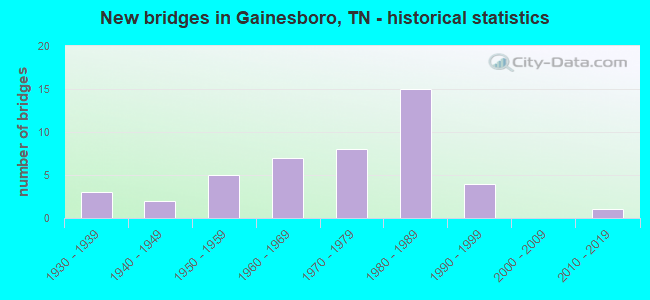
- New bridges - historical statistics
- 31930-1939
- 21940-1949
- 51950-1959
- 71960-1969
- 81970-1979
- 151980-1989
- 41990-1999
- 12010-2019

- Reconstructed bridges - Historical Statistics
- 11970-1979
- 01980-1989
- 11990-1999


- Bridge Condition - Deck
- 71.4%Good
- 14.3%Satisfactory
- 7.1%Poor
- 7.1%Imminent failure

- Bridge Condition - Superstructure
- 42.9%Good
- 42.9%Satisfactory
- 7.1%Fair
- 7.1%Imminent failure

- Bridge Condition - Substructure
- 71.4%Good
- 21.4%Fair
- 7.1%Imminent failure

- Bridge Condition - Channel
- 31.1%Good
- 48.9%Satisfactory
- 13.3%Fair
- 4.4%Poor
- 2.2%Imminent failure

- Bridge Condition - Culverts
- 83.9%Good
- 16.1%Satisfactory
Find on map >> Show street view
Structure Number: 44011500001, Location: 3MI SOUTHWEST OF SR56 (Lat: 36.280883, Lng: -85.661750), Route carried "on" structure: County highway 1150, Year Built: 1958, Status: Open, Structure Length: 0.79m (2.59ft), Average Daily Traffic: 306 (year 2020), Truck Traffic: 3%, Average Future Daily Traffic: 490 (year 2041), Features Intersected: LONG BRANCH
Minimum Vertical Clearance: 30+ m (98+ ft), Kilometerpoint: 6.518, Lanes on structure: 2, Owner: County Highway Agency, Approaching Roadway Width: 8.2m (26.9ft), Material/Design: Concrete continuous, Design/Construction: Culvert, Number Of Spans In Main Unit: 2, Length of Maximum Span: 3.7m (12.1ft)
Condition: Channel: Satisfactory, Culverts: Good, Operating Rating: 32.4 metric tons, Method Used To Determine Operating Rating: Load Factor (LF), Inventory Rating: 19.4 metric tons, Method Used To Determine Inventory Rating: Load Factor (LF), Structural Evaluation: Somewhat better than minimum adequacy, Waterway Adequacy: Somewhat better than minimum adequacy, Approach Roadway Alignment: Equal to present minimum criteria, Designated Inspection Frequency: Every 24 months, Inspection Date: September 2021
Find on map >> Show street view
Structure Number: 44011500003, Location: 4MI SOUTHWEST OF SR56 (Lat: 36.276817, Lng: -85.658983), Route carried "on" structure: County highway 1150, Year Built: 1958, Status: Open, Structure Length: 0.70m (2.30ft), Average Daily Traffic: 306 (year 2020), Truck Traffic: 3%, Average Future Daily Traffic: 490 (year 2041), Design Load: H 15, Features Intersected: BRANCH
Minimum Vertical Clearance: 30+ m (98+ ft), Kilometerpoint: 7.097, Lanes on structure: 2, Owner: County Highway Agency, Approaching Roadway Width: 9.1m (29.9ft), Skew: 1 degrees, Material/Design: Concrete continuous, Design/Construction: Culvert, Number Of Spans In Main Unit: 2, Length of Maximum Span: 3.0m (9.8ft)
Condition: Channel: Poor, Culverts: Good, Operating Rating: 55.1 metric tons, Method Used To Determine Operating Rating: Load Factor (LF), Inventory Rating: 32.4 metric tons, Method Used To Determine Inventory Rating: Load Factor (LF), Structural Evaluation: Better than present minimum criteria, Waterway Adequacy: Meets minimum limits, Approach Roadway Alignment: Equal to present minimum criteria, Designated Inspection Frequency: Every 24 months, Inspection Date: September 2021
Find on map >> Show street view
Structure Number: 44011500005, Location: 2MI SOUTHWEST OF SR56 (Lat: 36.272783, Lng: -85.641400), Route carried "on" structure: County highway 1150, Year Built: 1957, Status: Open, Structure Length: 0.70m (2.30ft), Average Daily Traffic: 529 (year 2020), Truck Traffic: 4%, Average Future Daily Traffic: 846 (year 2041), Design Load: H 20, Features Intersected: BRANCH
Minimum Vertical Clearance: 30+ m (98+ ft), Kilometerpoint: 8.980, Lanes on structure: 2, Owner: County Highway Agency, Approaching Roadway Width: 9.1m (29.9ft), Skew: 1 degrees, Material/Design: Concrete continuous, Design/Construction: Culvert, Number Of Spans In Main Unit: 2, Length of Maximum Span: 3.0m (9.8ft)
Condition: Channel: Satisfactory, Culverts: Good, Operating Rating: 36.0 metric tons, Method Used To Determine Operating Rating: Load Factor (LF), Inventory Rating: 24.3 metric tons, Method Used To Determine Inventory Rating: Load Factor (LF), Structural Evaluation: Equal to present minimum criteria, Waterway Adequacy: Equal to present minimum criteria, Approach Roadway Alignment: Equal to present desirable criteria, Designated Inspection Frequency: Every 24 months, Inspection Date: September 2021
Find on map >> Show street view
Structure Number: 44020840009, Location: .5 MI WEST OF SR53 (Lat: 36.326383, Lng: -85.715367), Route carried "on" structure: County highway 2730, Year Built: 1993, Status: Open, Structure Length: 3.60m (11.81ft), Average Daily Traffic: 94 (year 2020), Truck Traffic: 3%, Average Future Daily Traffic: 150 (year 2041), Design Load: HS 20, Features Intersected: FLYNN CREEK, Facility Carried by Structure: NFA 2084 (SA 4403)
Minimum Vertical Clearance: 30+ m (98+ ft), Kilometerpoint: 0.161, Lanes on structure: 2, Owner: County Highway Agency, Approaching Roadway Width: 8.2m (26.9ft), Skew: 4 degrees, Material/Design: Prestressed concrete continuous, Design/Construction: Stringer/Multi-beam, Number Of Spans In Main Unit: 3, Length of Maximum Span: 12.2m (40.0ft), Curb-To-Curb Width: 7.9m (25.9ft), Out-to-Out Width: 8.6m (28.2ft)
Condition: Deck: Satisfactory, Superstructure: Satisfactory, Substructure: Good, Channel: Satisfactory, Operating Rating: 52.2 metric tons, Method Used To Determine Operating Rating: Load Factor (LF), Inventory Rating: 29.7 metric tons, Method Used To Determine Inventory Rating: Load Factor (LF), Structural Evaluation: Equal to present minimum criteria, Deck Geometry: Equal to present minimum criteria, Waterway Adequacy: Better than present minimum criteria, Approach Roadway Alignment: Equal to present minimum criteria, Designated Inspection Frequency: Every 24 months, Inspection Date: September 2021, Deck Structure Type: Concrete Precast Panels, Wearing Surface/Protective System: Wearing Surface: Monolithic Concrete, Deck Protection: Epoxy Coated Reinforcing
Find on map >> Show street view
Structure Number: 44022460001, Location: .3MI EAST OF SR53 (Lat: 36.301917, Lng: -85.709050), Route carried "on" structure: County highway 2246, Year Built: 1984, Status: Open, Structure Length: 1.49m (4.89ft), Average Daily Traffic: 110 (year 2020), Truck Traffic: 4%, Average Future Daily Traffic: 176 (year 2041), Design Load: HS 20, Features Intersected: FLYNNS CREEK
Minimum Vertical Clearance: 30+ m (98+ ft), Kilometerpoint: 0.177, Lanes on structure: 2, Owner: County Highway Agency, Approaching Roadway Width: 6.7m (22.0ft), Skew: 1 degrees, Material/Design: Concrete continuous, Design/Construction: Culvert, Number Of Spans In Main Unit: 3, Length of Maximum Span: 4.6m (15.1ft), Curb-To-Curb Width: 6.6m (21.7ft), Out-to-Out Width: 8.0m (26.2ft)
Condition: Channel: Satisfactory, Culverts: Good, Operating Rating: 89.1 metric tons, Method Used To Determine Operating Rating: Load Factor (LF), Inventory Rating: 32.4 metric tons, Method Used To Determine Inventory Rating: Load Factor (LF), Structural Evaluation: Better than present minimum criteria, Deck Geometry: Meets minimum limits, Waterway Adequacy: Better than present minimum criteria, Approach Roadway Alignment: Equal to present minimum criteria, Designated Inspection Frequency: Every 24 months, Inspection Date: September 2021
Find on map >> Show street view
Structure Number: 440A1180001, Location: .01MI. EAST OF SR135 (Lat: 36.362550, Lng: -85.613633), Route carried "on" structure: County highway 118, Year Built: 1990, Status: Open, Structure Length: 8.96m (29.40ft), Average Daily Traffic: 180 (year 2022), Truck Traffic: 2%, Average Future Daily Traffic: 288 (year 2041), Design Load: HS 20, Features Intersected: ROARING RIVER
Minimum Vertical Clearance: 30+ m (98+ ft), Kilometerpoint: 0.016, Lanes on structure: 2, Owner: County Highway Agency, Approaching Roadway Width: 7.3m (24.0ft), Material/Design: Prestressed concrete continuous, Design/Construction: Stringer/Multi-beam, Number Of Spans In Main Unit: 4, Length of Maximum Span: 24.7m (81.0ft), Curb-To-Curb Width: 7.3m (24.0ft), Out-to-Out Width: 8.0m (26.2ft)
Condition: Deck: Good, Superstructure: Good, Substructure: Good, Channel: Good, Operating Rating: 44.1 metric tons, Method Used To Determine Operating Rating: Assigned rating based on Load Factor Design (LFD) reported in metric tons, Inventory Rating: 32.4 metric tons, Method Used To Determine Inventory Rating: Assigned rating based on Load Factor Design (LFD) reported in metric tons, Structural Evaluation: Better than present minimum criteria, Deck Geometry: Somewhat better than minimum adequacy, Waterway Adequacy: Equal to present desirable criteria, Approach Roadway Alignment: Equal to present desirable criteria, Designated Inspection Frequency: Every 24 months, Underwater Inspection Frequency: Every 60 months, Inspection Date: August 2021, Underwater Inspection Date: July 2019, Deck Structure Type: Concrete Precast Panels, Wearing Surface/Protective System: Wearing Surface: Monolithic Concrete, Deck Protection: Epoxy Coated Reinforcing
Find on map >> Show street view
Structure Number: 440A2120001, Location: .1MI EAST OF SR56 (Lat: 36.349667, Lng: -85.658367), Route carried "on" structure: City street 212, Year Built: 1965, Status: Open, Structure Length: 0.76m (2.49ft), Average Daily Traffic: 1,550 (year 2022), Truck Traffic: 2%, Average Future Daily Traffic: 2,480 (year 2041), Design Load: H 20, Features Intersected: GIBSON HOLLOW BRANCH
Minimum Vertical Clearance: 30+ m (98+ ft), Kilometerpoint: 0.079, Lanes on structure: 2, Owner: City or Municipal Highway Agency, Approaching Roadway Width: 15.5m (50.9ft), Skew: 3 degrees, Material/Design: Concrete continuous, Design/Construction: Culvert, Number Of Spans In Main Unit: 2, Length of Maximum Span: 3.0m (9.8ft), Curb-To-Curb Width: 14.3m (46.9ft), Out-to-Out Width: 16.5m (54.1ft)
Condition: Channel: Good, Culverts: Satisfactory, Operating Rating: 45.4 metric tons, Method Used To Determine Operating Rating: Load Factor (LF), Inventory Rating: 29.2 metric tons, Method Used To Determine Inventory Rating: Load Factor (LF), Structural Evaluation: Equal to present minimum criteria, Deck Geometry: Superior to present desirable criteria, Waterway Adequacy: Somewhat better than minimum adequacy, Approach Roadway Alignment: Equal to present desirable criteria, Designated Inspection Frequency: Every 24 months, Inspection Date: August 2021
Find on map >> Show street view
Structure Number: 440A2290001, Location: .11 MI FROM SR56 (Lat: 36.337617, Lng: -85.655083), Route carried "on" structure: County highway 421, Year Built: 1984, Status: Open, Structure Length: 1.04m (3.41ft), Average Daily Traffic: 140 (year 2022), Truck Traffic: 2%, Average Future Daily Traffic: 224 (year 2041), Design Load: HS 20, Features Intersected: DOE CREEK
Minimum Vertical Clearance: 30+ m (98+ ft), Kilometerpoint: 0.172, Lanes on structure: 2, Owner: County Highway Agency, Approaching Roadway Width: 6.7m (22.0ft), Material/Design: Concrete continuous, Design/Construction: Culvert, Number Of Spans In Main Unit: 2, Length of Maximum Span: 4.6m (15.1ft), Curb-To-Curb Width: 6.9m (22.6ft), Out-to-Out Width: 8.4m (27.6ft)
Condition: Channel: Fair, Culverts: Good, Operating Rating: 68.0 metric tons, Method Used To Determine Operating Rating: Load Factor (LF), Inventory Rating: 32.4 metric tons, Method Used To Determine Inventory Rating: Load Factor (LF), Structural Evaluation: Better than present minimum criteria, Deck Geometry: Meets minimum limits, Waterway Adequacy: Equal to present minimum criteria, Approach Roadway Alignment: Equal to present minimum criteria, Designated Inspection Frequency: Every 24 months, Inspection Date: August 2021
Find on map >> Show street view
Structure Number: 440A2350001, Location: 2 MI WEST OF SR 56 (Lat: 36.274883, Lng: -85.658033), Route carried "on" structure: County highway 235, Year Built: 1985, Status: Open, Structure Length: 1.52m (4.99ft), Average Daily Traffic: 150 (year 2022), Truck Traffic: 2%, Average Future Daily Traffic: 240 (year 2041), Design Load: H 10, Features Intersected: FLYNN CREEK
Minimum Vertical Clearance: 30+ m (98+ ft), Kilometerpoint: 0.014, Lanes on structure: 2, Owner: County Highway Agency, Approaching Roadway Width: 2.4m (7.9ft), Skew: 1 degrees, Material/Design: Concrete continuous, Design/Construction: Culvert, Number Of Spans In Main Unit: 3, Length of Maximum Span: 4.6m (15.1ft), Curb-To-Curb Width: 8.7m (28.5ft), Out-to-Out Width: 9.9m (32.5ft)
Condition: Channel: Good, Culverts: Good, Operating Rating: 51.8 metric tons, Method Used To Determine Operating Rating: Load Factor (LF), Inventory Rating: 32.4 metric tons, Method Used To Determine Inventory Rating: Load Factor (LF), Structural Evaluation: Better than present minimum criteria, Deck Geometry: Equal to present minimum criteria, Waterway Adequacy: Somewhat better than minimum adequacy, Approach Roadway Alignment: Equal to present minimum criteria, Designated Inspection Frequency: Every 24 months, Inspection Date: September 2021
Find on map >> Show street view
Structure Number: 440A2350009, Location: .41 M FROM FLYNN CREEK RD (Lat: 36.269917, Lng: -85.657733), Route carried "on" structure: County highway 235, Year Built: 1987, Status: Posted for load, Structure Length: 0.64m (2.10ft), Average Daily Traffic: 50 (year 2022), Truck Traffic: 2%, Average Future Daily Traffic: 80 (year 2041), Features Intersected: BRANCH
Minimum Vertical Clearance: 30+ m (98+ ft), Kilometerpoint: 0.599, Lanes on structure: 2, Owner: County Highway Agency, Approaching Roadway Width: 5.5m (18.0ft), Skew: 1 degrees, Material/Design: Steel, Design/Construction: Stringer/Multi-beam, Number Of Spans In Main Unit: 1, Length of Maximum Span: 6.1m (20.0ft), Curb-To-Curb Width: 5.8m (19.0ft), Out-to-Out Width: 5.8m (19.0ft)
Condition: Deck: Satisfactory, Superstructure: Satisfactory, Substructure: Fair, Channel: Good, Operating Rating: 29.7 metric tons, Method Used To Determine Operating Rating: Load Factor (LF), Inventory Rating: 18.0 metric tons, Method Used To Determine Inventory Rating: Load Factor (LF), Structural Evaluation: Somewhat better than minimum adequacy, Deck Geometry: Meets minimum limits, Waterway Adequacy: Equal to present minimum criteria, Approach Roadway Alignment: Equal to present minimum criteria, Bridge Posting: Required (Relationship of Operating Rating to Maximum Legal Load: 0.1 - 9.9% below), Length Of Structure Improvement: 0.64m (2.10ft), Designated Inspection Frequency: Every 24 months, Inspection Date: September 2021, Bridge Improvement Cost: $55,000, Roadway Improvement Cost: $6,000, Total Project Cost: $83,000 ( Estimate for 2021), Deck Structure Type: Concrete Cast-file-Place, Wearing Surface/Protective System: Wearing Surface: Bituminous
Find on map >> Show street view
Structure Number: 440A2650001, Location: 2MI EAST OF SR53 (Lat: 36.294000, Lng: -85.694400), Route carried "on" structure: County highway 265, Year Built: 1984, Status: Open, Structure Length: 0.73m (2.40ft), Average Daily Traffic: 30 (year 2022), Truck Traffic: 2%, Average Future Daily Traffic: 48 (year 2041), Design Load: HS 20, Features Intersected: FLYNN CREEK
Minimum Vertical Clearance: 30+ m (98+ ft), Kilometerpoint: 0.163, Lanes on structure: 2, Owner: County Highway Agency, Approaching Roadway Width: 5.5m (18.0ft), Skew: 4 degrees, Material/Design: Concrete, Design/Construction: Culvert, Number Of Spans In Main Unit: 1, Length of Maximum Span: 4.6m (15.1ft), Curb-To-Curb Width: 7.1m (23.3ft), Out-to-Out Width: 8.2m (26.9ft)
Condition: Channel: Poor, Culverts: Satisfactory, Operating Rating: 89.1 metric tons, Method Used To Determine Operating Rating: Load Factor (LF), Inventory Rating: 32.4 metric tons, Method Used To Determine Inventory Rating: Load Factor (LF), Structural Evaluation: Equal to present minimum criteria, Deck Geometry: Somewhat better than minimum adequacy, Waterway Adequacy: Better than present minimum criteria, Approach Roadway Alignment: High priority of corrective action, Designated Inspection Frequency: Every 24 months, Inspection Date: September 2021, Deck Structure Type: Concrete Cast-file-Place, Wearing Surface/Protective System: Wearing Surface: Monolithic Concrete, Deck Protection: Epoxy Coated Reinforcing
Find on map >> Show street view
Structure Number: 440A2650003, Location: 2MI EAST OF SR53 (Lat: 36.292983, Lng: -85.694183), Route carried "on" structure: County highway 265, Year Built: 1986, Status: Open, Structure Length: 1.77m (5.81ft), Average Daily Traffic: 30 (year 2022), Truck Traffic: 2%, Average Future Daily Traffic: 48 (year 2041), Design Load: HS 20, Features Intersected: FLYNN CREEK
Minimum Vertical Clearance: 30+ m (98+ ft), Kilometerpoint: 0.280, Lanes on structure: 2, Owner: County Highway Agency, Approaching Roadway Width: 4.9m (16.1ft), Material/Design: Concrete continuous, Design/Construction: Culvert, Number Of Spans In Main Unit: 3, Length of Maximum Span: 5.5m (18.0ft), Curb-To-Curb Width: 6.7m (22.0ft), Out-to-Out Width: 7.8m (25.6ft)
Condition: Channel: Satisfactory, Culverts: Satisfactory, Operating Rating: 89.9 metric tons, Method Used To Determine Operating Rating: Load Factor (LF), Inventory Rating: 32.4 metric tons, Method Used To Determine Inventory Rating: Load Factor (LF), Structural Evaluation: Equal to present minimum criteria, Deck Geometry: Somewhat better than minimum adequacy, Waterway Adequacy: Somewhat better than minimum adequacy, Approach Roadway Alignment: High priority of corrective action, Designated Inspection Frequency: Every 24 months, Inspection Date: September 2021, Deck Structure Type: Concrete Cast-file-Place, Wearing Surface/Protective System: Wearing Surface: Monolithic Concrete, Deck Protection: Epoxy Coated Reinforcing
Find on map >> Show street view
Structure Number: 440A2650005, Location: 4MI EAST OF SR53 (Lat: 36.284767, Lng: -85.681017), Route carried "on" structure: County highway 265, Year Built: 1987, Status: Open, Structure Length: 1.77m (5.81ft), Average Daily Traffic: 30 (year 2022), Truck Traffic: 2%, Average Future Daily Traffic: 48 (year 2041), Design Load: HS 20, Features Intersected: FLYNN CREEK
Minimum Vertical Clearance: 30+ m (98+ ft), Kilometerpoint: 1.814, Lanes on structure: 2, Owner: County Highway Agency, Approaching Roadway Width: 7.9m (25.9ft), Material/Design: Concrete continuous, Design/Construction: Culvert, Number Of Spans In Main Unit: 3, Length of Maximum Span: 5.5m (18.0ft), Curb-To-Curb Width: 6.8m (22.3ft), Out-to-Out Width: 8.0m (26.2ft)
Condition: Channel: Fair, Culverts: Good, Operating Rating: 89.9 metric tons, Method Used To Determine Operating Rating: Load Factor (LF), Inventory Rating: 32.4 metric tons, Method Used To Determine Inventory Rating: Load Factor (LF), Structural Evaluation: Better than present minimum criteria, Deck Geometry: Somewhat better than minimum adequacy, Waterway Adequacy: Better than present minimum criteria, Approach Roadway Alignment: Equal to present desirable criteria, Designated Inspection Frequency: Every 24 months, Inspection Date: September 2021, Deck Structure Type: Concrete Cast-file-Place, Wearing Surface/Protective System: Wearing Surface: Bituminous, Deck Protection: Epoxy Coated Reinforcing
Find on map >> Show street view
Structure Number: 440A2680001, Location: 6MI EAST OF SR53 (Lat: 36.280550, Lng: -85.679950), Route carried "on" structure: County highway 268, Year Built: 1960, Status: Closed, Structure Length: 1.74m (5.71ft), Average Daily Traffic: 10 (year 2022), Truck Traffic: 2%, Average Future Daily Traffic: 16 (year 2041), Design Load: H 10, Features Intersected: FLYNN CREEK
Minimum Vertical Clearance: 30+ m (98+ ft), Kilometerpoint: 0.109, Lanes on structure: 1, Owner: County Highway Agency, Approaching Roadway Width: 4.5m (14.8ft), Material/Design: Steel, Design/Construction: Stringer/Multi-beam, Number Of Spans In Main Unit: 1, Length of Maximum Span: 16.5m (54.1ft), Curb-To-Curb Width: 3.7m (12.1ft), Out-to-Out Width: 4.3m (14.1ft)
Condition: Deck: Imminent failure, Superstructure: Imminent failure, Substructure: Imminent failure, Channel: Imminent failure, Deck Geometry: Meets minimum limits, Approach Roadway Alignment: Equal to present minimum criteria, Bridge Posting: Required (Relationship of Operating Rating to Maximum Legal Load: > 39.9% below), Length Of Structure Improvement: 1.74m (5.71ft), Designated Inspection Frequency: Every 24 months, Inspection Date: September 2021, Bridge Improvement Cost: $180,000, Roadway Improvement Cost: $19,000, Total Project Cost: $271,000 ( Estimate for 2021), Deck Structure Type: Wood or Timber, Wearing Surface/Protective System: Wearing Surface: Wood or Timber
Find on map >> Show street view
Structure Number: 440A2690001, Location: 7MI EAST OF SR53 (Lat: 36.278417, Lng: -85.672833), Route carried "on" structure: County highway 269, Year Built: 1970, Status: Open, Structure Length: 1.19m (3.90ft), Average Daily Traffic: 40 (year 2022), Truck Traffic: 2%, Average Future Daily Traffic: 64 (year 2041), Design Load: H 15, Features Intersected: FLYNN CREEK
Minimum Vertical Clearance: 30+ m (98+ ft), Kilometerpoint: 0.100, Lanes on structure: 1, Owner: County Highway Agency, Approaching Roadway Width: 5.5m (18.0ft), Material/Design: Concrete continuous, Design/Construction: Culvert, Number Of Spans In Main Unit: 3, Length of Maximum Span: 3.7m (12.1ft), Curb-To-Curb Width: 3.6m (11.8ft), Out-to-Out Width: 5.0m (16.4ft)
Condition: Channel: Satisfactory, Culverts: Good, Operating Rating: 89.9 metric tons, Method Used To Determine Operating Rating: Load Factor (LF), Inventory Rating: 32.4 metric tons, Method Used To Determine Inventory Rating: Load Factor (LF), Structural Evaluation: Better than present minimum criteria, Deck Geometry: High priority of corrective action, Waterway Adequacy: Equal to present minimum criteria, Approach Roadway Alignment: Better than present minimum criteria, Length Of Structure Improvement: 1.19m (3.90ft), Designated Inspection Frequency: Every 24 months, Inspection Date: September 2021, Bridge Improvement Cost: $103,000, Roadway Improvement Cost: $11,000, Total Project Cost: $155,000 ( Estimate for 2021), Deck Structure Type: Concrete Cast-file-Place, Wearing Surface/Protective System: Wearing Surface: Monolithic Concrete
Find on map >> Show street view
Structure Number: 440A2830001, Location: 3MI EAST OF CUMBERLAND RV (Lat: 36.317733, Lng: -85.714550), Route carried "on" structure: County highway 283, Year Built: 1960, Status: Posted for load, Structure Length: 1.28m (4.20ft), Average Daily Traffic: 30 (year 2022), Truck Traffic: 2%, Average Future Daily Traffic: 48 (year 2042), Features Intersected: FLYNN CREEK
Minimum Vertical Clearance: 30+ m (98+ ft), Kilometerpoint: 0.209, Lanes on structure: 1, Owner: County Highway Agency, Approaching Roadway Width: 4.0m (13.1ft), Material/Design: Steel, Design/Construction: Stringer/Multi-beam, Number Of Spans In Main Unit: 1, Length of Maximum Span: 12.2m (40.0ft), Curb-To-Curb Width: 3.3m (10.8ft), Out-to-Out Width: 3.6m (11.8ft)
Condition: Deck: Poor, Superstructure: Fair, Substructure: Fair, Channel: Fair, Operating Rating: 6.7 metric tons, Method Used To Determine Operating Rating: Allowable Stress (AS), Inventory Rating: 5.0 metric tons, Method Used To Determine Inventory Rating: Allowable Stress (AS), Structural Evaluation: High priority of corrective action, Deck Geometry: High priority of replacement, Waterway Adequacy: Better than present minimum criteria, Approach Roadway Alignment: Equal to present minimum criteria, Bridge Posting: Required (Relationship of Operating Rating to Maximum Legal Load: 10.0 - 19.9% below), Length Of Structure Improvement: 1.28m (4.20ft), Designated Inspection Frequency: Every 24 months, Inspection Date: September 2021, Bridge Improvement Cost: $160,000, Roadway Improvement Cost: $17,000, Total Project Cost: $241,000 ( Estimate for 2022), Deck Structure Type: Wood or Timber, Wearing Surface/Protective System: Wearing Surface: Wood or Timber
Find on map >> Show street view
Structure Number: 440A2930001, Location: 8MI SO WEST OF GAINSBORO (Lat: 36.340033, Lng: -85.722850), Route carried "on" structure: County highway 293, Year Built: 1986, Status: Open, Structure Length: 3.32m (10.89ft), Average Daily Traffic: 180 (year 2022), Truck Traffic: 2%, Average Future Daily Traffic: 288 (year 2041), Design Load: HS 20, Features Intersected: FLYNN CREEK
Minimum Vertical Clearance: 30+ m (98+ ft), Kilometerpoint: 5.670, Lanes on structure: 2, Owner: County Highway Agency, Approaching Roadway Width: 6.7m (22.0ft), Skew: 3 degrees, Material/Design: Prestressed concrete continuous, Design/Construction: Box Beam or Girders - Single/Spread, Number Of Spans In Main Unit: 3, Length of Maximum Span: 11.3m (37.1ft), Curb-To-Curb Width: 6.7m (22.0ft), Out-to-Out Width: 7.4m (24.3ft)
Condition: Deck: Good, Superstructure: Good, Substructure: Good, Channel: Satisfactory, Operating Rating: 61.2 metric tons, Method Used To Determine Operating Rating: Load Factor (LF), Inventory Rating: 32.4 metric tons, Method Used To Determine Inventory Rating: Load Factor (LF), Structural Evaluation: Better than present minimum criteria, Deck Geometry: Meets minimum limits, Waterway Adequacy: Equal to present desirable criteria, Approach Roadway Alignment: High priority of corrective action, Designated Inspection Frequency: Every 24 months, Underwater Inspection Frequency: Every 60 months, Inspection Date: September 2021, Underwater Inspection Date: July 2019, Deck Structure Type: Concrete Precast Panels, Wearing Surface/Protective System: Wearing Surface: Bituminous
Find on map >> Show street view
Structure Number: 440A2930003, Location: 3.57 MI FROM SR53 (Lat: 36.339933, Lng: -85.722217), Route carried "on" structure: County highway 293, Year Built: 1985, Status: Open, Structure Length: 1.19m (3.90ft), Average Daily Traffic: 180 (year 2022), Truck Traffic: 2%, Average Future Daily Traffic: 288 (year 2041), Design Load: HS 20, Features Intersected: OVERFLOW OF FLYNN CREEK
Minimum Vertical Clearance: 30+ m (98+ ft), Kilometerpoint: 5.724, Lanes on structure: 2, Owner: County Highway Agency, Approaching Roadway Width: 6.1m (20.0ft), Material/Design: Concrete continuous, Design/Construction: Culvert, Number Of Spans In Main Unit: 3, Length of Maximum Span: 3.7m (12.1ft), Curb-To-Curb Width: 6.9m (22.6ft), Out-to-Out Width: 7.9m (25.9ft)
Condition: Channel: Fair, Culverts: Good, Operating Rating: 45.4 metric tons, Method Used To Determine Operating Rating: Load Factor (LF), Inventory Rating: 24.3 metric tons, Method Used To Determine Inventory Rating: Load Factor (LF), Structural Evaluation: Equal to present minimum criteria, Deck Geometry: Meets minimum limits, Waterway Adequacy: Equal to present desirable criteria, Approach Roadway Alignment: Equal to present minimum criteria, Designated Inspection Frequency: Every 24 months, Inspection Date: September 2021, Deck Structure Type: Concrete Cast-file-Place, Wearing Surface/Protective System: Wearing Surface: Monolithic Concrete, Deck Protection: Epoxy Coated Reinforcing
Find on map >> Show street view
Structure Number: 440A3390001, Location: IN CITY OF GAINSBORO (Lat: 36.354667, Lng: -85.655217), Route carried "on" structure: City street 339, Year Built: 1970, Status: Open, Structure Length: 1.25m (4.10ft), Average Daily Traffic: 270 (year 2022), Truck Traffic: 2%, Average Future Daily Traffic: 432 (year 2041), Design Load: H 15, Features Intersected: DOE CREEK
Minimum Vertical Clearance: 30+ m (98+ ft), Kilometerpoint: 0.277, Lanes on structure: 2, Owner: City or Municipal Highway Agency, Approaching Roadway Width: 7.9m (25.9ft), Skew: 1 degrees, Material/Design: Concrete continuous, Design/Construction: Culvert, Number Of Spans In Main Unit: 3, Length of Maximum Span: 3.7m (12.1ft), Curb-To-Curb Width: 6.8m (22.3ft), Out-to-Out Width: 8.2m (26.9ft)
Condition: Channel: Good, Culverts: Good, Operating Rating: 48.6 metric tons, Method Used To Determine Operating Rating: Load Factor (LF), Inventory Rating: 29.2 metric tons, Method Used To Determine Inventory Rating: Load Factor (LF), Structural Evaluation: Better than present minimum criteria, Deck Geometry: Meets minimum limits, Waterway Adequacy: Better than present minimum criteria, Approach Roadway Alignment: High priority of corrective action, Length Of Structure Improvement: 1.25m (4.10ft), Designated Inspection Frequency: Every 24 months, Inspection Date: August 2021, Bridge Improvement Cost: $55,000, Roadway Improvement Cost: $6,000, Total Project Cost: $83,000 ( Estimate for 2021), Deck Structure Type: Concrete Cast-file-Place, Wearing Surface/Protective System: Wearing Surface: Bituminous
Find on map >> Show street view
Structure Number: 440A3530001, Location: IN CITY OF GAINSBORO (Lat: 36.350250, Lng: -85.656533), Route carried "on" structure: City street 353, Year Built: 1970, Status: Open, Structure Length: 1.28m (4.20ft), Average Daily Traffic: 370 (year 2022), Truck Traffic: 2%, Average Future Daily Traffic: 592 (year 2041), Design Load: H 15, Features Intersected: DOE CREEK
Minimum Vertical Clearance: 30+ m (98+ ft), Kilometerpoint: 0.264, Lanes on structure: 2, Owner: City or Municipal Highway Agency, Approaching Roadway Width: 9.8m (32.2ft), Skew: 1 degrees, Material/Design: Concrete continuous, Design/Construction: Culvert, Number Of Spans In Main Unit: 3, Length of Maximum Span: 3.7m (12.1ft), Curb-To-Curb Width: 12.1m (39.7ft), Out-to-Out Width: 13.5m (44.3ft)
Condition: Channel: Satisfactory, Culverts: Good, Operating Rating: 87.5 metric tons, Method Used To Determine Operating Rating: Load Factor (LF), Inventory Rating: 32.4 metric tons, Method Used To Determine Inventory Rating: Load Factor (LF), Structural Evaluation: Better than present minimum criteria, Deck Geometry: Superior to present desirable criteria, Waterway Adequacy: Better than present minimum criteria, Approach Roadway Alignment: Equal to present minimum criteria, Designated Inspection Frequency: Every 24 months, Inspection Date: August 2021, Deck Structure Type: Concrete Cast-file-Place, Wearing Surface/Protective System: Wearing Surface: Bituminous
Find on map >> Show street view
Structure Number: 440A3580001, Location: IN CITY OF GAINSBORO (Lat: 36.372333, Lng: -85.654883), Route carried "on" structure: City street 358, Year Built: 1985, Status: Open, Structure Length: 2.59m (8.50ft), Average Daily Traffic: 430 (year 2022), Truck Traffic: 2%, Average Future Daily Traffic: 688 (year 2041), Design Load: HS 20, Features Intersected: DOE CREEK
Minimum Vertical Clearance: 30+ m (98+ ft), Kilometerpoint: 0.626, Lanes on structure: 2, Owner: City or Municipal Highway Agency, Approaching Roadway Width: 7.3m (24.0ft), Material/Design: Prestressed concrete, Design/Construction: Box Beam or Girders - Single/Spread, Number Of Spans In Main Unit: 1, Length of Maximum Span: 25.3m (83.0ft), Curb-To-Curb Width: 6.7m (22.0ft), Out-to-Out Width: 7.3m (24.0ft)
Condition: Deck: Good, Superstructure: Satisfactory, Substructure: Good, Channel: Good, Operating Rating: 55.8 metric tons, Method Used To Determine Operating Rating: Load Factor (LF), Inventory Rating: 25.2 metric tons, Method Used To Determine Inventory Rating: Load Factor (LF), Structural Evaluation: Equal to present minimum criteria, Deck Geometry: Meets minimum limits, Waterway Adequacy: Better than present minimum criteria, Approach Roadway Alignment: Equal to present desirable criteria, Length Of Structure Improvement: 2.59m (8.50ft), Designated Inspection Frequency: Every 24 months, Inspection Date: August 2021, Bridge Improvement Cost: $455,000, Roadway Improvement Cost: $46,000, Total Project Cost: $683,000 ( Estimate for 2021), Deck Structure Type: Concrete Precast Panels, Wearing Surface/Protective System: Wearing Surface: Monolithic Concrete
Find on map >> Show street view
Structure Number: 440A3910001, Location: 0.01 MI. E OF SR-56 JCT. (Lat: 36.346633, Lng: -85.657967), Route carried "on" structure: City street 391, Year Built: 2016, Status: Open, Structure Length: 1.04m (3.41ft), Average Daily Traffic: 20 (year 2022), Truck Traffic: 2%, Average Future Daily Traffic: 32 (year 2039), Design Load: HL 93, Features Intersected: DOE CREEK
Minimum Vertical Clearance: 30+ m (98+ ft), Kilometerpoint: 0.021, Lanes on structure: 1, Owner: City or Municipal Highway Agency, Approaching Roadway Width: 3.1m (10.2ft), Skew: 2 degrees, Material/Design: Concrete continuous, Design/Construction: Culvert, Number Of Spans In Main Unit: 2, Length of Maximum Span: 4.3m (14.1ft), Curb-To-Curb Width: 4.4m (14.4ft), Out-to-Out Width: 4.4m (14.4ft)
Condition: Channel: Satisfactory, Culverts: Good, Operating Rating: 44.1 metric tons, Method Used To Determine Operating Rating: Assigned ratings based on Load and Resistance Factor Design (LRFD) reported by rating factor (RF) using HL93 loadings, Inventory Rating: 32.4 metric tons, Method Used To Determine Inventory Rating: Assigned ratings based on Load and Resistance Factor Design (LRFD) reported by rating factor (RF) using HL93 loadings, Structural Evaluation: Better than present minimum criteria, Deck Geometry: Equal to present minimum criteria, Waterway Adequacy: Equal to present minimum criteria, Approach Roadway Alignment: Better than present minimum criteria, Designated Inspection Frequency: Every 24 months, Inspection Date: September 2021, Deck Structure Type: Concrete Cast-file-Place, Wearing Surface/Protective System: Wearing Surface: Monolithic Concrete, Deck Protection: Epoxy Coated Reinforcing
Find on map >> Show street view
Structure Number: 44F00080001, Location: IN CITY OF GAINSBORO (Lat: 36.349017, Lng: -85.657500), Route carried "on" structure: City street 1171, Year Built: 1972, Status: Open, Structure Length: 1.19m (3.90ft), Average Daily Traffic: 809 (year 2020), Truck Traffic: 3%, Average Future Daily Traffic: 1,294 (year 2041), Design Load: H 15, Features Intersected: DOE CREEK
Minimum Vertical Clearance: 30+ m (98+ ft), Kilometerpoint: 0.016, Lanes on structure: 2, Owner: City or Municipal Highway Agency, Approaching Roadway Width: 8.5m (27.9ft), Material/Design: Concrete continuous, Design/Construction: Culvert, Number Of Spans In Main Unit: 3, Length of Maximum Span: 3.7m (12.1ft), Curb or Sidewalk Widths: Left: 0.0m, Right: 1.5m (4.9ft), Curb-To-Curb Width: 10.5m (34.4ft), Out-to-Out Width: 13.3m (43.6ft)
Condition: Channel: Satisfactory, Culverts: Good, Operating Rating: 48.6 metric tons, Method Used To Determine Operating Rating: Load Factor (LF), Inventory Rating: 32.4 metric tons, Method Used To Determine Inventory Rating: Load Factor (LF), Structural Evaluation: Better than present minimum criteria, Deck Geometry: Equal to present minimum criteria, Waterway Adequacy: Equal to present minimum criteria, Approach Roadway Alignment: Equal to present minimum criteria, Designated Inspection Frequency: Every 24 months, Inspection Date: August 2021, Deck Structure Type: Concrete Cast-file-Place, Wearing Surface/Protective System: Wearing Surface: Bituminous
Find on map >> Show street view
Structure Number: 44S62930001, Location: .11MI EAST OF SR53 (Lat: 36.322267, Lng: -85.710300), Route carried "on" structure: County highway 1148, Year Built: 1960, Status: Open, Structure Length: 0.76m (2.49ft), Average Daily Traffic: 169 (year 2020), Truck Traffic: 3%, Average Future Daily Traffic: 270 (year 2041), Design Load: H 15, Features Intersected: SHAKE RAG CREEK
Minimum Vertical Clearance: 30+ m (98+ ft), Kilometerpoint: 0.177, Lanes on structure: 2, Owner: County Highway Agency, Approaching Roadway Width: 8.8m (28.9ft), Skew: 3 degrees, Material/Design: Concrete continuous, Design/Construction: Culvert, Number Of Spans In Main Unit: 2, Length of Maximum Span: 3.0m (9.8ft)
Condition: Channel: Fair, Culverts: Good, Operating Rating: 25.9 metric tons, Method Used To Determine Operating Rating: Load Factor (LF), Inventory Rating: 16.2 metric tons, Method Used To Determine Inventory Rating: Load Factor (LF), Structural Evaluation: Somewhat better than minimum adequacy, Waterway Adequacy: Somewhat better than minimum adequacy, Approach Roadway Alignment: Equal to present desirable criteria, Length Of Structure Improvement: 1.41m (4.63ft), Designated Inspection Frequency: Every 24 months, Inspection Date: September 2021, Bridge Improvement Cost: $282,000, Roadway Improvement Cost: $29,000, Total Project Cost: $424,000 ( Estimate for 2021)
Find on map >> Show street view
Structure Number: 44SR0530001, Location: IN GRANVILLE (Lat: 36.272233, Lng: -85.799450), Route carried "on" structure: State highway 53, Year Built: 1998, Status: Open, Structure Length: 14.42m (47.31ft), Average Daily Traffic: 543 (year 2020), Truck Traffic: 5%, Average Future Daily Traffic: 869 (year 2041), Design Load: HS 20, Features Intersected: MARTIN CREEK
Minimum Vertical Clearance: 30+ m (98+ ft), Kilometerpoint: 1.980, Lanes on structure: 2, Owner: State Highway Agency, Approaching Roadway Width: 8.5m (27.9ft), Material/Design: Steel continuous, Design/Construction: Stringer/Multi-beam, Number Of Spans In Main Unit: 2, Length of Maximum Span: 72.1m (236.5ft), Curb-To-Curb Width: 8.5m (27.9ft), Out-to-Out Width: 9.2m (30.2ft)
Condition: Deck: Good, Superstructure: Good, Substructure: Good, Channel: Good, Operating Rating: 42.3 metric tons, Method Used To Determine Operating Rating: Load Factor (LF), Inventory Rating: 25.2 metric tons, Method Used To Determine Inventory Rating: Load Factor (LF), Structural Evaluation: Equal to present minimum criteria, Deck Geometry: Somewhat better than minimum adequacy, Waterway Adequacy: Equal to present desirable criteria, Approach Roadway Alignment: Equal to present desirable criteria, Designated Inspection Frequency: Every 24 months, Underwater Inspection Frequency: Every 60 months, Inspection Date: July 2021, Underwater Inspection Date: August 2019, Deck Structure Type: Concrete Precast Panels, Wearing Surface/Protective System: Wearing Surface: Monolithic Concrete, Deck Protection: Epoxy Coated Reinforcing
Find on map >> Show street view
Structure Number: 44SR0530003, Location: 1.5 MI.S.OF FLYNN'S LICK (Lat: 36.306400, Lng: -85.711900), Route carried "on" structure: State highway 53, Year Built: 1935, Status: Posted for load, Structure Length: 4.85m (15.91ft), Average Daily Traffic: 499 (year 2020), Truck Traffic: 4%, Average Future Daily Traffic: 816 (year 2040), Design Load: H 15, Features Intersected: FLYNN CREEK
Minimum Vertical Clearance: 30+ m (98+ ft), Kilometerpoint: 12.617, Lanes on structure: 2, Owner: State Highway Agency, Approaching Roadway Width: 7.3m (24.0ft), Material/Design: Concrete, Design/Construction: Tee Beam, Number Of Spans In Main Unit: 6, Length of Maximum Span: 8.2m (26.9ft), Curb-To-Curb Width: 6.1m (20.0ft), Out-to-Out Width: 7.1m (23.3ft)
Condition: Deck: Good, Superstructure: Satisfactory, Substructure: Good, Channel: Satisfactory, Operating Rating: 39.6 metric tons, Method Used To Determine Operating Rating: Load Factor (LF), Inventory Rating: 23.4 metric tons, Method Used To Determine Inventory Rating: Load Factor (LF), Structural Evaluation: Equal to present minimum criteria, Deck Geometry: High priority of corrective action, Waterway Adequacy: Somewhat better than minimum adequacy, Approach Roadway Alignment: Equal to present desirable criteria, Length Of Structure Improvement: 4.85m (15.91ft), Designated Inspection Frequency: Every 24 months, Inspection Date: July 2021, Bridge Improvement Cost: $315,000, Roadway Improvement Cost: $32,000, Total Project Cost: $473,000 ( Estimate for 2020), Deck Structure Type: Concrete Cast-file-Place, Wearing Surface/Protective System: Wearing Surface: Bituminous
Find on map >> Show street view
Structure Number: 44SR0530005, Location: NEAR FLYNN'S LICK (Lat: 36.317783, Lng: -85.712333), Route carried "on" structure: State highway 53, Year Built: 1934, Status: Open, Structure Length: 0.73m (2.40ft), Average Daily Traffic: 1,080 (year 2020), Truck Traffic: 2%, Average Future Daily Traffic: 1,728 (year 2041), Design Load: H 15, Features Intersected: BUFFALO CREEK
Minimum Vertical Clearance: 30+ m (98+ ft), Kilometerpoint: 13.969, Lanes on structure: 2, Owner: State Highway Agency, Approaching Roadway Width: 8.5m (27.9ft), Material/Design: Concrete continuous, Design/Construction: Culvert, Number Of Spans In Main Unit: 2, Length of Maximum Span: 3.0m (9.8ft), Curb-To-Curb Width: 7.3m (24.0ft), Out-to-Out Width: 8.4m (27.6ft)
Condition: Channel: Satisfactory, Culverts: Good, Operating Rating: 42.1 metric tons, Method Used To Determine Operating Rating: Load Factor (LF), Inventory Rating: 25.9 metric tons, Method Used To Determine Inventory Rating: Load Factor (LF), Structural Evaluation: Equal to present minimum criteria, Deck Geometry: Meets minimum limits, Waterway Adequacy: Equal to present minimum criteria, Approach Roadway Alignment: Equal to present desirable criteria, Length Of Structure Improvement: 0.73m (2.40ft), Designated Inspection Frequency: Every 24 months, Inspection Date: July 2021, Bridge Improvement Cost: $67,000, Roadway Improvement Cost: $7,000, Total Project Cost: $101,000 ( Estimate for 2021)
Find on map >> Show street view
Structure Number: 44SR0530007, Location: IN FLYNN'S LICK (Lat: 36.322183, Lng: -85.712383), Route carried "on" structure: State highway 53, Year Built: 1984, Status: Open, Structure Length: 1.01m (3.31ft), Average Daily Traffic: 1,080 (year 2020), Truck Traffic: 2%, Average Future Daily Traffic: 1,728 (year 2041), Design Load: HS 20, Features Intersected: SHAKE RAG CREEK
Minimum Vertical Clearance: 30+ m (98+ ft), Kilometerpoint: 14.452, Lanes on structure: 2, Owner: State Highway Agency, Approaching Roadway Width: 8.5m (27.9ft), Skew: 10 degrees, Material/Design: Concrete continuous, Design/Construction: Culvert, Number Of Spans In Main Unit: 3, Length of Maximum Span: 3.0m (9.8ft), Curb-To-Curb Width: 10.6m (34.8ft), Out-to-Out Width: 11.9m (39.0ft)
Condition: Channel: Satisfactory, Culverts: Good, Operating Rating: 89.9 metric tons, Method Used To Determine Operating Rating: Load Factor (LF), Inventory Rating: 32.4 metric tons, Method Used To Determine Inventory Rating: Load Factor (LF), Structural Evaluation: Better than present minimum criteria, Deck Geometry: Equal to present minimum criteria, Waterway Adequacy: Better than present minimum criteria, Approach Roadway Alignment: Equal to present desirable criteria, Designated Inspection Frequency: Every 24 months, Inspection Date: July 2021, Deck Structure Type: Concrete Cast-file-Place, Wearing Surface/Protective System: Wearing Surface: Bituminous
Find on map >> Show street view
Structure Number: 44SR0530009, Location: 1.7 MI.N.OF FLYNN'S LICK (Lat: 36.347533, Lng: -85.698483), Route carried "on" structure: State highway 53, Year Built: 1984, Status: Open, Structure Length: 1.37m (4.49ft), Average Daily Traffic: 1,080 (year 2020), Truck Traffic: 2%, Average Future Daily Traffic: 1,728 (year 2041), Design Load: HS 20, Features Intersected: HOPKINS BRANCH
Minimum Vertical Clearance: 30+ m (98+ ft), Kilometerpoint: 17.993, Lanes on structure: 2, Owner: State Highway Agency, Approaching Roadway Width: 9.1m (29.9ft), Skew: 13 degrees, Material/Design: Concrete continuous, Design/Construction: Culvert, Number Of Spans In Main Unit: 3, Length of Maximum Span: 3.7m (12.1ft), Curb-To-Curb Width: 10.6m (34.8ft), Out-to-Out Width: 11.9m (39.0ft)
Condition: Channel: Satisfactory, Culverts: Good, Operating Rating: 58.3 metric tons, Method Used To Determine Operating Rating: Load Factor (LF), Inventory Rating: 32.4 metric tons, Method Used To Determine Inventory Rating: Load Factor (LF), Structural Evaluation: Better than present minimum criteria, Deck Geometry: Equal to present minimum criteria, Waterway Adequacy: Better than present minimum criteria, Approach Roadway Alignment: Equal to present desirable criteria, Designated Inspection Frequency: Every 24 months, Inspection Date: July 2021
Find on map >> Show street view
Structure Number: 44SR0530011, Location: 2.2 MI.N.OF FLYNN'S LICK (Lat: 36.349300, Lng: -85.694733), Route carried "on" structure: State highway 53, Year Built: 1984, Status: Open, Structure Length: 0.82m (2.69ft), Average Daily Traffic: 1,080 (year 2020), Truck Traffic: 2%, Average Future Daily Traffic: 1,728 (year 2041), Design Load: HS 20, Features Intersected: POORHOUSE CREEK
Minimum Vertical Clearance: 30+ m (98+ ft), Kilometerpoint: 18.395, Lanes on structure: 2, Owner: State Highway Agency, Approaching Roadway Width: 9.1m (29.9ft), Skew: 10 degrees, Material/Design: Concrete continuous, Design/Construction: Culvert, Number Of Spans In Main Unit: 2, Length of Maximum Span: 3.7m (12.1ft), Curb-To-Curb Width: 14.5m (47.6ft), Out-to-Out Width: 15.7m (51.5ft)
Condition: Channel: Good, Culverts: Good, Operating Rating: 89.9 metric tons, Method Used To Determine Operating Rating: Load Factor (LF), Inventory Rating: 32.4 metric tons, Method Used To Determine Inventory Rating: Load Factor (LF), Structural Evaluation: Better than present minimum criteria, Deck Geometry: Superior to present desirable criteria, Waterway Adequacy: Better than present minimum criteria, Approach Roadway Alignment: Equal to present minimum criteria, Designated Inspection Frequency: Every 24 months, Inspection Date: July 2021
Find on map >> Show street view
Structure Number: 44SR0530015, Location: 3 MI. N. OF GAINSBORO (Lat: 36.374133, Lng: -85.646217), Route carried "on" structure: State highway 53, Year Built: 1972, Status: Posted for load, Structure Length: 21.34m (70.01ft), Average Daily Traffic: 3,376 (year 2020), Truck Traffic: 7%, Average Future Daily Traffic: 5,920 (year 2040), Design Load: HS 20, Features Intersected: ROARING RIVER
Minimum Vertical Clearance: 30+ m (98+ ft), Kilometerpoint: 25.299, Lanes on structure: 2, Base Highway Network: Yes, Owner: State Highway Agency, Approaching Roadway Width: 13.4m (44.0ft), Skew: 3 degrees, Material/Design: Steel continuous, Design/Construction: Girder and Floorbeam System, Number Of Spans In Main Unit: 4, Length of Maximum Span: 71.6m (234.9ft), Curb-To-Curb Width: 14.6m (47.9ft), Out-to-Out Width: 15.2m (49.9ft)
Condition: Deck: Good, Superstructure: Satisfactory, Substructure: Good, Channel: Good, Operating Rating: 32.4 metric tons, Method Used To Determine Operating Rating: Load Factor (LF), Inventory Rating: 19.8 metric tons, Method Used To Determine Inventory Rating: Load Factor (LF), Structural Evaluation: Somewhat better than minimum adequacy, Deck Geometry: Superior to present desirable criteria, Waterway Adequacy: Better than present minimum criteria, Approach Roadway Alignment: Equal to present minimum criteria, Length Of Structure Improvement: 21.66m (71.06ft), Designated Inspection Frequency: Every 24 months, Critical Feature Inspection Frequency: Every 24 months, Underwater Inspection Frequency: Every 60 months, Inspection Date: July 2021, Critical Feature Inspection Date: July 2021, Underwater Inspection Date: June 2017, Bridge Improvement Cost: $9,554,000, Roadway Improvement Cost: $956,000, Total Project Cost: $14,332,000 ( Estimate for 2020), Deck Structure Type: Concrete Cast-file-Place, Wearing Surface/Protective System: Wearing Surface: Bituminous
Find on map >> Show street view
Structure Number: 44SR0530017, Location: MI.N.OF GAINESBORO (Lat: 36.396683, Lng: -85.634683), Route carried "on" structure: State highway 53, Year Built: 1978, Status: Open, Structure Length: 1.10m (3.61ft), Average Daily Traffic: 2,323 (year 2020), Truck Traffic: 7%, Average Future Daily Traffic: 3,717 (year 2041), Design Load: HS 20, Features Intersected: HURRICANE CREEK
Minimum Vertical Clearance: 30+ m (98+ ft), Kilometerpoint: 28.260, Lanes on structure: 2, Base Highway Network: Yes, Owner: State Highway Agency, Approaching Roadway Width: 14.0m (45.9ft), Material/Design: Steel, Design/Construction: Culvert, Number Of Spans In Main Unit: 2, Length of Maximum Span: 4.6m (15.1ft)
Condition: Channel: Good, Culverts: Satisfactory, Operating Rating: 89.1 metric tons, Method Used To Determine Operating Rating: Load Factor (LF), Inventory Rating: 32.4 metric tons, Method Used To Determine Inventory Rating: Load Factor (LF), Structural Evaluation: Equal to present minimum criteria, Waterway Adequacy: Equal to present minimum criteria, Approach Roadway Alignment: Equal to present desirable criteria, Designated Inspection Frequency: Every 24 months, Inspection Date: July 2021
Find on map >> Show street view
Structure Number: 44SR0530029, Location: 3.5 MI S OF GAINESBORB TN (Lat: 36.340333, Lng: -85.701750), Route carried "on" structure: State highway 53, Year Built: 1935, Status: Open, Structure Length: 0.64m (2.10ft), Average Daily Traffic: 1,080 (year 2020), Truck Traffic: 2%, Average Future Daily Traffic: 1,728 (year 2041), Features Intersected: BRANCH
Minimum Vertical Clearance: 30+ m (98+ ft), Kilometerpoint: 17.091, Lanes on structure: 2, Owner: State Highway Agency, Approaching Roadway Width: 7.0m (23.0ft), Skew: 3 degrees, Material/Design: Concrete continuous, Design/Construction: Culvert, Number Of Spans In Main Unit: 2, Length of Maximum Span: 2.4m (7.9ft), Out-to-Out Width: 8.5m (27.9ft)
Condition: Channel: Satisfactory, Culverts: Good, Operating Rating: 36.0 metric tons, Method Used To Determine Operating Rating: Load Factor (LF), Inventory Rating: 22.5 metric tons, Method Used To Determine Inventory Rating: Load Factor (LF), Structural Evaluation: Equal to present minimum criteria, Waterway Adequacy: Better than present minimum criteria, Approach Roadway Alignment: Equal to present desirable criteria, Designated Inspection Frequency: Every 24 months, Inspection Date: July 2021
Find on map >> Show street view
Structure Number: 44SR0560001, Location: 1.5 MI.S.OF GAINESBORO (Lat: 36.319750, Lng: -85.655250), Route carried "on" structure: State highway 56, Year Built: 1963, Status: Open, Structure Length: 0.76m (2.49ft), Average Daily Traffic: 5,719 (year 2020), Truck Traffic: 11%, Average Future Daily Traffic: 9,150 (year 2041), Design Load: HS 20, Features Intersected: DOE CREEK
Minimum Vertical Clearance: 30+ m (98+ ft), Kilometerpoint: 13.438, Lanes on structure: 2, Base Highway Network: Yes, Owner: State Highway Agency, Approaching Roadway Width: 13.4m (44.0ft), Skew: 3 degrees, Material/Design: Concrete continuous, Design/Construction: Culvert, Number Of Spans In Main Unit: 2, Length of Maximum Span: 3.0m (9.8ft)
Condition: Channel: Satisfactory, Culverts: Good, Operating Rating: 68.0 metric tons, Method Used To Determine Operating Rating: Load Factor (LF), Inventory Rating: 32.4 metric tons, Method Used To Determine Inventory Rating: Load Factor (LF), Structural Evaluation: Better than present minimum criteria, Waterway Adequacy: Better than present minimum criteria, Approach Roadway Alignment: Equal to present desirable criteria, Designated Inspection Frequency: Every 24 months, Inspection Date: July 2021
Find on map >> Show street view
Structure Number: 44SR0560003, Location: 1.1 MI.S.OF GAINESBORO (Lat: 36.323983, Lng: -85.658033), Route carried "on" structure: State highway 56, Year Built: 1963, Status: Open, Structure Length: 0.76m (2.49ft), Average Daily Traffic: 5,719 (year 2020), Truck Traffic: 11%, Average Future Daily Traffic: 9,150 (year 2041), Design Load: HS 20, Features Intersected: DOE CREEK
Minimum Vertical Clearance: 30+ m (98+ ft), Kilometerpoint: 13.985, Lanes on structure: 2, Base Highway Network: Yes, Owner: State Highway Agency, Approaching Roadway Width: 13.4m (44.0ft), Skew: 3 degrees, Material/Design: Concrete continuous, Design/Construction: Culvert, Number Of Spans In Main Unit: 2, Length of Maximum Span: 3.0m (9.8ft)
Condition: Channel: Satisfactory, Culverts: Good, Operating Rating: 89.9 metric tons, Method Used To Determine Operating Rating: Load Factor (LF), Inventory Rating: 32.4 metric tons, Method Used To Determine Inventory Rating: Load Factor (LF), Structural Evaluation: Better than present minimum criteria, Waterway Adequacy: Better than present minimum criteria, Approach Roadway Alignment: Equal to present desirable criteria, Designated Inspection Frequency: Every 24 months, Inspection Date: July 2021
Find on map >> Show street view
Structure Number: 44SR0560005, Location: SOUTH OF GAINESBORO (Lat: 36.333750, Lng: -85.658167), Route carried "on" structure: State highway 56, Year Built: 1963, Status: Open, Structure Length: 1.40m (4.59ft), Average Daily Traffic: 5,719 (year 2020), Truck Traffic: 11%, Average Future Daily Traffic: 9,150 (year 2041), Design Load: HS 20, Features Intersected: DOE CREEK
Minimum Vertical Clearance: 30+ m (98+ ft), Kilometerpoint: 15.047, Lanes on structure: 2, Base Highway Network: Yes, Owner: State Highway Agency, Approaching Roadway Width: 13.4m (44.0ft), Skew: 4 degrees, Material/Design: Concrete continuous, Design/Construction: Culvert, Number Of Spans In Main Unit: 3, Length of Maximum Span: 3.0m (9.8ft)
Condition: Channel: Good, Culverts: Good, Operating Rating: 58.3 metric tons, Method Used To Determine Operating Rating: Load Factor (LF), Inventory Rating: 32.4 metric tons, Method Used To Determine Inventory Rating: Load Factor (LF), Structural Evaluation: Better than present minimum criteria, Waterway Adequacy: Better than present minimum criteria, Approach Roadway Alignment: Equal to present desirable criteria, Designated Inspection Frequency: Every 24 months, Inspection Date: July 2021
Find on map >> Show street view
Structure Number: 44SR0560007, Location: IN GAINESBORO CITY LIMITS (Lat: 36.356267, Lng: -85.655283), Route carried "on" structure: State highway 56, Year Built: 1972, Status: Open, Structure Length: 0.98m (3.22ft), Average Daily Traffic: 5,990 (year 2020), Truck Traffic: 11%, Average Future Daily Traffic: 9,584 (year 2041), Design Load: HS 20, Features Intersected: DOE CREEK
Minimum Vertical Clearance: 30+ m (98+ ft), Kilometerpoint: 17.574, Lanes on structure: 2, Base Highway Network: Yes, Owner: State Highway Agency, Approaching Roadway Width: 19.5m (64.0ft), Skew: 4 degrees, Material/Design: Concrete continuous, Design/Construction: Culvert, Number Of Spans In Main Unit: 2, Length of Maximum Span: 3.0m (9.8ft)
Condition: Channel: Good, Culverts: Satisfactory, Operating Rating: 89.9 metric tons, Method Used To Determine Operating Rating: Load Factor (LF), Inventory Rating: 32.4 metric tons, Method Used To Determine Inventory Rating: Load Factor (LF), Structural Evaluation: Equal to present minimum criteria, Waterway Adequacy: Better than present minimum criteria, Approach Roadway Alignment: Equal to present desirable criteria, Designated Inspection Frequency: Every 24 months, Inspection Date: July 2021
Find on map >> Show street view
Structure Number: 44SR0560009, Location: IN GAINESBORO (Lat: 36.372767, Lng: -85.652283), Route carried "on" structure: State highway 56, Year Built: 1994, Status: Open, Structure Length: 24.84m (81.50ft), Average Daily Traffic: 3,197 (year 2020), Truck Traffic: 7%, Average Future Daily Traffic: 5,115 (year 2042), Design Load: HS 20, Features Intersected: CUMBERLAND RIVER
Minimum Vertical Clearance: 30+ m (98+ ft), Kilometerpoint: 17.671, Lanes on structure: 2, Base Highway Network: Yes, Owner: State Highway Agency, Approaching Roadway Width: 13.4m (44.0ft), Navigation Control: Yes ( Vertical Clearance: 22.2m (72.8ft), Horizontal Clearance: 82.2m (269.7ft)), Material/Design: Steel continuous, Design/Construction: Stringer/Multi-beam, Number Of Spans In Main Unit: 3, Length of Maximum Span: 100.6m (330.1ft), Curb-To-Curb Width: 14.6m (47.9ft), Out-to-Out Width: 15.2m (49.9ft)
Condition: Deck: Good, Superstructure: Good, Substructure: Good, Channel: Satisfactory, Operating Rating: 44.1 metric tons, Method Used To Determine Operating Rating: Assigned rating based on Load Factor Design (LFD) reported in metric tons, Inventory Rating: 32.4 metric tons, Method Used To Determine Inventory Rating: Assigned rating based on Load Factor Design (LFD) reported in metric tons, Structural Evaluation: Better than present minimum criteria, Deck Geometry: Superior to present desirable criteria, Waterway Adequacy: Equal to present desirable criteria, Approach Roadway Alignment: Equal to present minimum criteria, Designated Inspection Frequency: Every 24 months, Underwater Inspection Frequency: Every 60 months, Inspection Date: July 2021, Underwater Inspection Date: August 2021, Deck Structure Type: Concrete Cast-file-Place, Wearing Surface/Protective System: Wearing Surface: Monolithic Concrete, Deck Protection: Epoxy Coated Reinforcing
Find on map >> Show street view
Structure Number: 44SR0560011, Location: 0.7 MI N OF SR85 (Lat: 36.428117, Lng: -85.661967), Route carried "on" structure: State highway 56, Year Built: 1951, Status: Open, Structure Length: 0.64m (2.10ft), Average Daily Traffic: 991 (year 2020), Truck Traffic: 7%, Average Future Daily Traffic: 1,586 (year 2041), Design Load: H 15, Features Intersected: BRANCH
Minimum Vertical Clearance: 30+ m (98+ ft), Kilometerpoint: 25.299, Lanes on structure: 2, Base Highway Network: Yes, Owner: State Highway Agency, Approaching Roadway Width: 9.8m (32.2ft), Skew: 3 degrees, Material/Design: Concrete continuous, Design/Construction: Culvert, Number Of Spans In Main Unit: 2, Length of Maximum Span: 2.4m (7.9ft)
Condition: Channel: Satisfactory, Culverts: Good, Operating Rating: 42.3 metric tons, Method Used To Determine Operating Rating: Load Factor (LF), Inventory Rating: 26.1 metric tons, Method Used To Determine Inventory Rating: Load Factor (LF), Structural Evaluation: Equal to present minimum criteria, Waterway Adequacy: Better than present minimum criteria, Approach Roadway Alignment: Equal to present minimum criteria, Designated Inspection Frequency: Every 24 months, Inspection Date: June 2021
Find on map >> Show street view
Structure Number: 44SR0560029, Location: IN GAINESBORO CITY LIMITS (Lat: 36.349533, Lng: -85.657517), Route carried "on" structure: State highway 56, Year Built: 1972, Status: Open, Structure Length: 1.71m (5.61ft), Average Daily Traffic: 5,990 (year 2020), Truck Traffic: 11%, Average Future Daily Traffic: 9,584 (year 2041), Design Load: H 20, Features Intersected: GIBSON HOLLOW BRANCH
Minimum Vertical Clearance: 30+ m (98+ ft), Kilometerpoint: 16.898, Lanes on structure: 2, Base Highway Network: Yes, Owner: State Highway Agency, Approaching Roadway Width: 19.5m (64.0ft), Skew: 4 degrees, Material/Design: Concrete continuous, Design/Construction: Culvert, Number Of Spans In Main Unit: 3, Length of Maximum Span: 3.7m (12.1ft)
Condition: Channel: Satisfactory, Culverts: Good, Operating Rating: 68.0 metric tons, Method Used To Determine Operating Rating: Load Factor (LF), Inventory Rating: 32.4 metric tons, Method Used To Determine Inventory Rating: Load Factor (LF), Structural Evaluation: Better than present minimum criteria, Waterway Adequacy: Better than present minimum criteria, Approach Roadway Alignment: Equal to present desirable criteria, Designated Inspection Frequency: Every 24 months, Inspection Date: July 2021
Find on map >> Show street view
Structure Number: 44SR0850007, Location: 1 MI.FROM SR.56 (Lat: 36.419667, Lng: -85.673267), Route carried "on" structure: State highway 85, Year Built: 1981, Status: Open, Structure Length: 6.37m (20.90ft), Average Daily Traffic: 216 (year 2020), Truck Traffic: 6%, Average Future Daily Traffic: 346 (year 2041), Design Load: HS 20, Features Intersected: JENNINGS CREEK
Minimum Vertical Clearance: 30+ m (98+ ft), Kilometerpoint: 24.253, Lanes on structure: 2, Owner: State Highway Agency, Approaching Roadway Width: 11.0m (36.1ft), Material/Design: Prestressed concrete continuous, Design/Construction: Stringer/Multi-beam, Number Of Spans In Main Unit: 3, Length of Maximum Span: 21.3m (69.9ft), Curb-To-Curb Width: 8.7m (28.5ft), Out-to-Out Width: 9.8m (32.2ft)
Condition: Deck: Good, Superstructure: Good, Substructure: Good, Channel: Satisfactory, Operating Rating: 42.3 metric tons, Method Used To Determine Operating Rating: Load Factor (LF), Inventory Rating: 32.4 metric tons, Method Used To Determine Inventory Rating: Load Factor (LF), Structural Evaluation: Better than present minimum criteria, Deck Geometry: Equal to present minimum criteria, Waterway Adequacy: Equal to present desirable criteria, Approach Roadway Alignment: Equal to present desirable criteria, Designated Inspection Frequency: Every 24 months, Underwater Inspection Frequency: Every 60 months, Inspection Date: July 2021, Underwater Inspection Date: November 2018, Deck Structure Type: Concrete Precast Panels, Wearing Surface/Protective System: Wearing Surface: Bituminous, Membrane: Preformed Fabric
Find on map >> Show street view
Structure Number: 44SR0852001, Location: 3.8 MI.W.OF GAINESBORO (Lat: 36.355817, Lng: -85.720950), Route carried "on" structure: State highway 262, Year Built: 1949, Year Reconstructed: 2001, Status: Open, Structure Length: 2.62m (8.60ft), Average Daily Traffic: 1,334 (year 2020), Truck Traffic: 7%, Average Future Daily Traffic: 2,134 (year 2041), Design Load: HS 20, Features Intersected: BULLARD CREEK
Minimum Vertical Clearance: 30+ m (98+ ft), Kilometerpoint: 8.224, Lanes on structure: 2, Base Highway Network: Yes, Owner: State Highway Agency, Approaching Roadway Width: 9.8m (32.2ft), Skew: 3 degrees, Material/Design: Concrete, Design/Construction: Tee Beam, Number Of Spans In Main Unit: 3, Length of Maximum Span: 8.8m (28.9ft), Curb-To-Curb Width: 8.2m (26.9ft), Out-to-Out Width: 9.4m (30.8ft)
Condition: Deck: Good, Superstructure: Good, Substructure: Fair, Channel: Good, Operating Rating: 53.1 metric tons, Method Used To Determine Operating Rating: Load Factor (LF), Inventory Rating: 32.4 metric tons, Method Used To Determine Inventory Rating: Load Factor (LF), Structural Evaluation: Somewhat better than minimum adequacy, Deck Geometry: Meets minimum limits, Waterway Adequacy: Better than present minimum criteria, Approach Roadway Alignment: Equal to present desirable criteria, Designated Inspection Frequency: Every 24 months, Inspection Date: June 2021, Deck Structure Type: Concrete Cast-file-Place, Wearing Surface/Protective System: Wearing Surface: Monolithic Concrete, Deck Protection: Epoxy Coated Reinforcing
Find on map >> Show street view
Structure Number: 44SR0852003, Location: 1.5 MI W OF SR85 (Lat: 36.357650, Lng: -85.697233), Route carried "on" structure: State highway 262, Year Built: 1949, Year Reconstructed: 1970, Status: Open, Structure Length: 0.70m (2.30ft), Average Daily Traffic: 1,334 (year 2020), Truck Traffic: 7%, Average Future Daily Traffic: 2,134 (year 2041), Design Load: HS 20, Features Intersected: TRACE CREEK
Minimum Vertical Clearance: 30+ m (98+ ft), Kilometerpoint: 10.670, Lanes on structure: 2, Base Highway Network: Yes, Owner: State Highway Agency, Approaching Roadway Width: 11.9m (39.0ft), Material/Design: Concrete continuous, Design/Construction: Culvert, Number Of Spans In Main Unit: 2, Length of Maximum Span: 3.0m (9.8ft)
Condition: Channel: Good, Culverts: Good, Operating Rating: 54.0 metric tons, Method Used To Determine Operating Rating: Field evaluation and documented engineering judgment, Inventory Rating: 32.4 metric tons, Method Used To Determine Inventory Rating: Field evaluation and documented engineering judgment, Structural Evaluation: Better than present minimum criteria, Waterway Adequacy: Better than present minimum criteria, Approach Roadway Alignment: Equal to present desirable criteria, Designated Inspection Frequency: Every 24 months, Underwater Inspection Frequency: Every 60 months, Inspection Date: June 2021, Underwater Inspection Date: June 2017
Find on map >> Show street view
Structure Number: 44SR0852005, Location: 1.35 MI.W.OF GAINSBORO (Lat: 36.361050, Lng: -85.681100), Route carried "on" structure: State highway 262, Year Built: 1959, Status: Open, Structure Length: 22.86m (75.00ft), Average Daily Traffic: 1,685 (year 2020), Truck Traffic: 7%, Average Future Daily Traffic: 2,696 (year 2041), Design Load: HS 20, Features Intersected: CUMBERLAND RIVER
Minimum Vertical Clearance: 30+ m (98+ ft), Kilometerpoint: 12.167, Lanes on structure: 2, Base Highway Network: Yes, Owner: State Highway Agency, Approaching Roadway Width: 10.4m (34.1ft), Navigation Control: Yes ( Vertical Clearance: 10.3m (33.8ft), Horizontal Clearance: 82.2m (269.7ft)), Material/Design: Steel continuous, Design/Construction: Girder and Floorbeam System, Number Of Spans In Main Unit: 3, Number Of Approach Spans: 4, Length of Maximum Span: 85.3m (279.9ft), Curb-To-Curb Width: 8.5m (27.9ft), Out-to-Out Width: 10.5m (34.4ft)
Condition: Deck: Good, Superstructure: Satisfactory, Substructure: Good, Channel: Fair, Operating Rating: 45.9 metric tons, Method Used To Determine Operating Rating: Load Factor (LF), Inventory Rating: 27.5 metric tons, Method Used To Determine Inventory Rating: Load Factor (LF), Structural Evaluation: Equal to present minimum criteria, Deck Geometry: Somewhat better than minimum adequacy, Waterway Adequacy: Better than present minimum criteria, Approach Roadway Alignment: Equal to present desirable criteria, Length Of Structure Improvement: 22.86m (75.00ft), Designated Inspection Frequency: Every 24 months, Critical Feature Inspection Frequency: Every 24 months, Underwater Inspection Frequency: Every 60 months, Inspection Date: July 2021, Critical Feature Inspection Date: July 2021, Underwater Inspection Date: June 2017, Bridge Improvement Cost: $6,394,000, Roadway Improvement Cost: $640,000, Total Project Cost: $9,592,000 ( Estimate for 2021), Deck Structure Type: Concrete Cast-file-Place, Wearing Surface/Protective System: Wearing Surface: Bituminous, Membrane: Preformed Fabric