Bridge Statistics for Geneseo, Illinois (IL)
Condition, Traffic, Stress, Structural Evaluation, Project Costs
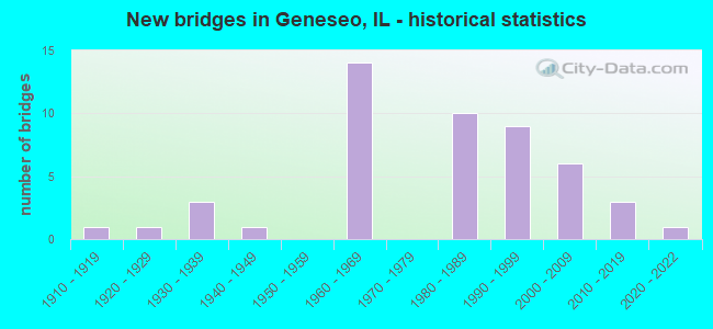
- New bridges - historical statistics
- 11910-1919
- 11920-1929
- 31930-1939
- 11940-1949
- 141960-1969
- 101980-1989
- 91990-1999
- 62000-2009
- 32010-2019
- 12020-2022
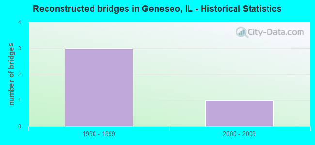
- Reconstructed bridges - Historical Statistics
- 31990-1999
- 12000-2009
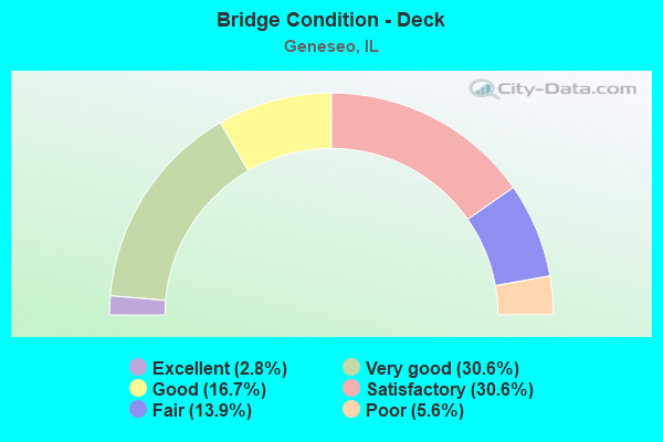
- Bridge Condition - Deck
- 2.8%Excellent
- 30.6%Very good
- 16.7%Good
- 30.6%Satisfactory
- 13.9%Fair
- 5.6%Poor
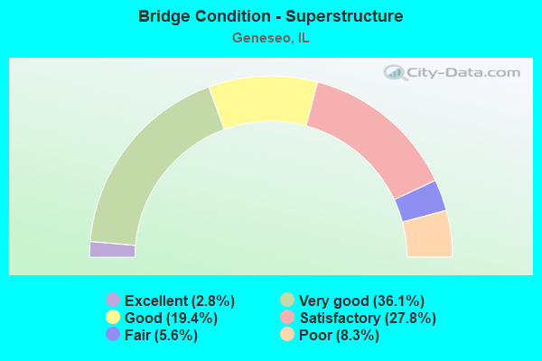
- Bridge Condition - Superstructure
- 2.8%Excellent
- 36.1%Very good
- 19.4%Good
- 27.8%Satisfactory
- 5.6%Fair
- 8.3%Poor
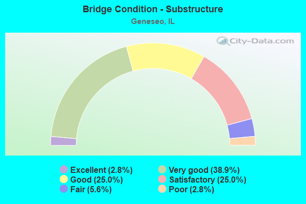
- Bridge Condition - Substructure
- 2.8%Excellent
- 38.9%Very good
- 25.0%Good
- 25.0%Satisfactory
- 5.6%Fair
- 2.8%Poor
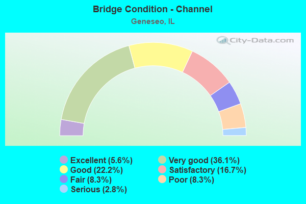
- Bridge Condition - Channel
- 5.6%Excellent
- 36.1%Very good
- 22.2%Good
- 16.7%Satisfactory
- 8.3%Fair
- 8.3%Poor
- 2.8%Serious
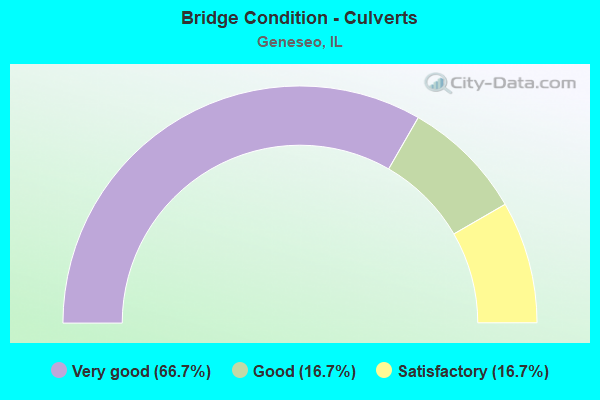
- Bridge Condition - Culverts
- 66.7%Very good
- 16.7%Good
- 16.7%Satisfactory
Find on map >> Show street view
Structure Number: 376002, Location: NW CORNER OF GENESEO (Lat: 41.460333, Lng: -90.167514), Route carried "on" structure: City street , Year Built: 1938, Status: Open, Structure Length: 3.35m (10.99ft), Average Daily Traffic: 550 (year 2020), Truck Traffic: 11%, Average Future Daily Traffic: 1,700 (year 2040), Design Load: H 15, Features Intersected: GENESEO CREEK, Facility Carried by Structure: W ELK STREET
Minimum Vertical Clearance: 30+ m (98+ ft), Kilometerpoint: 0.129, Lanes on structure: 2, Owner: City or Municipal Highway Agency, Approaching Roadway Width: 9.1m (29.9ft), Material/Design: Steel continuous, Design/Construction: Stringer/Multi-beam, Number Of Spans In Main Unit: 3, Length of Maximum Span: 12.5m (41.0ft), Curb-To-Curb Width: 7.3m (24.0ft), Out-to-Out Width: 8.4m (27.6ft)
Condition: Deck: Satisfactory, Superstructure: Fair, Substructure: Good, Channel: Fair, Operating Rating: 33.0 metric tons, Method Used To Determine Operating Rating: Allowable Stress (AS) rating reported by rating factor (RF) method using MS18 loading, Inventory Rating: 24.3 metric tons, Method Used To Determine Inventory Rating: Allowable Stress (AS) rating reported by rating factor (RF) method using MS18 loading, Structural Evaluation: Somewhat better than minimum adequacy, Deck Geometry: Meets minimum limits, Waterway Adequacy: Better than present minimum criteria, Approach Roadway Alignment: Somewhat better than minimum adequacy, Designated Inspection Frequency: Every 24 months, Inspection Date: November 2020, Deck Structure Type: Concrete Cast-file-Place
Find on map >> Show street view
Structure Number: 376003, Location: SO CENTER OF GENESEO (Lat: 41.439464, Lng: -90.155864), Route carried "on" structure: Other road , Year Built: 1982, Status: Open, Structure Length: 2.19m (7.19ft), Average Daily Traffic: 3,050 (year 2020), Truck Traffic: 2%, Average Future Daily Traffic: 3,500 (year 2040), Design Load: HS 20, Features Intersected: GENESEO CREEK, Facility Carried by Structure: SO STATE STREET
Minimum Vertical Clearance: 30+ m (98+ ft), Kilometerpoint: 2.494, Lanes on structure: 2, Owner: City or Municipal Highway Agency, Approaching Roadway Width: 8.5m (27.9ft), Skew: 3 degrees, Material/Design: Concrete, Design/Construction: Box Beam or Girders - Multiple, Number Of Spans In Main Unit: 1, Length of Maximum Span: 20.1m (65.9ft), Curb-To-Curb Width: 8.9m (29.2ft), Out-to-Out Width: 9.2m (30.2ft)
Condition: Deck: Good, Superstructure: Good, Substructure: Good, Channel: Good, Operating Rating: 44.4 metric tons, Method Used To Determine Operating Rating: Assigned rating based on Load Factor Design (LFD) reported by rating factor (RF) using MS18 loading, Inventory Rating: 32.4 metric tons, Method Used To Determine Inventory Rating: Assigned rating based on Load Factor Design (LFD) reported by rating factor (RF) using MS18 loading, Structural Evaluation: Better than present minimum criteria, Deck Geometry: Meets minimum limits, Waterway Adequacy: Equal to present minimum criteria, Approach Roadway Alignment: Equal to present desirable criteria, Designated Inspection Frequency: Every 48 months, Inspection Date: November 2018, Deck Structure Type: Concrete Precast Panels, Wearing Surface/Protective System: Wearing Surface: Bituminous, Membrane: Preformed Fabric
Find on map >> Show street view
Structure Number: 376004, Location: SO CENTER OF GENESEO (Lat: 41.437886, Lng: -90.155778), Route carried "on" structure: Other road , Year Built: 1985, Year Reconstructed: 2014, Status: Open, Structure Length: 2.63m (8.63ft), Average Daily Traffic: 2,700 (year 2020), Truck Traffic: 5%, Average Future Daily Traffic: 2,800 (year 2040), Design Load: HS 20, Features Intersected: GENESEO CREEK, Facility Carried by Structure: SOUTH STATE STREET
Minimum Vertical Clearance: 30+ m (98+ ft), Kilometerpoint: 2.671, Lanes on structure: 2, Owner: City or Municipal Highway Agency, Approaching Roadway Width: 9.8m (32.2ft), Skew: 3 degrees, Material/Design: Prestressed concrete, Design/Construction: Box Beam or Girders - Multiple, Number Of Spans In Main Unit: 3, Length of Maximum Span: 8.2m (26.9ft), Curb-To-Curb Width: 9.1m (29.9ft), Out-to-Out Width: 9.1m (29.9ft)
Condition: Deck: Very good, Superstructure: Good, Substructure: Very good, Channel: Very good, Operating Rating: 42.1 metric tons, Method Used To Determine Operating Rating: Assigned ratings based on Load and Resistance Factor Design (LRFD) reported by rating factor (RF) using HL93 loadings, Inventory Rating: 32.4 metric tons, Method Used To Determine Inventory Rating: Assigned ratings based on Load and Resistance Factor Design (LRFD) reported by rating factor (RF) using HL93 loadings, Structural Evaluation: Better than present minimum criteria, Deck Geometry: Meets minimum limits, Waterway Adequacy: Equal to present desirable criteria, Approach Roadway Alignment: Equal to present minimum criteria, Designated Inspection Frequency: Every 48 months, Inspection Date: November 2020, Deck Structure Type: Concrete Precast Panels, Wearing Surface/Protective System: Wearing Surface: Bituminous, Membrane: Built-up, Deck Protection: Epoxy Coated Reinforcing
Find on map >> Show street view
Structure Number: 37011, Location: 4.0 MI W JCT ILL 82 (Lat: 41.440469, Lng: -90.231100), Route carried "under" structure: Interstate 80, Year Built: 1961, Structure Length: 0. m, Average Daily Traffic: 20,400 (year 2021), Truck Traffic: 45%, Features Intersected: FAI 80, Facility Carried by Structure: CAMBRIDGE RD/FAS23
Minimum Vertical Clearance: 4.72m (15.49ft), Kilometerpoint: 24.687, Lanes on structure: 2, Lanes under structure: 4, Material/Design: Concrete continuous, Design/Construction: Tee Beam, Length of Maximum Span: 20.6m (67.6ft)
Find on map >> Show street view
Structure Number: 370111, Location: 1.0 MI W OF GENESEO (Lat: 41.440625, Lng: -90.182247), Route carried "under" structure: Interstate 80, Year Built: 1961, Structure Length: 0. m, Average Daily Traffic: 20,400 (year 2021), Truck Traffic: 45%, Features Intersected: FAI 80, Facility Carried by Structure: TR 172
Minimum Vertical Clearance: 5.18m (16.99ft), Kilometerpoint: 28.774, Lanes on structure: 2, Lanes under structure: 4, Material/Design: Concrete continuous, Design/Construction: Tee Beam, Length of Maximum Span: 20.7m (67.9ft)
Find on map >> Show street view
Structure Number: 370112, Location: .34 MI E GENESEO (Lat: 41.422611, Lng: -90.144319), Route carried "under" structure: Interstate 80, Year Built: 1961, Structure Length: 0. m, Average Daily Traffic: 18,000 (year 2021), Truck Traffic: 50%, Features Intersected: FAI 80, Facility Carried by Structure: TR 196-D
Minimum Vertical Clearance: 4.93m (16.17ft), Kilometerpoint: 32.588, Lanes on structure: 2, Lanes under structure: 4, Material/Design: Steel continuous, Design/Construction: Stringer/Multi-beam, Length of Maximum Span: 25.9m (85.0ft)
Find on map >> Show street view
Structure Number: 370113, Location: 2.5 MI SE OF GENESEO (Lat: 41.415311, Lng: -90.124981), Route carried "under" structure: Interstate 80, Year Built: 1961, Structure Length: 0. m, Average Daily Traffic: 18,000 (year 2021), Truck Traffic: 50%, Features Intersected: FAI 80, Facility Carried by Structure: TR 216
Minimum Vertical Clearance: 4.93m (16.17ft), Kilometerpoint: 34.423, Lanes on structure: 2, Lanes under structure: 4, Material/Design: Steel continuous, Design/Construction: Stringer/Multi-beam, Length of Maximum Span: 20.7m (67.9ft)
Find on map >> Show street view
Structure Number: 370169, Location: S EDGE GENESEO (Lat: 41.430350, Lng: -90.157781), Route carried "under" structure: State highway 82, Year Built: 2003, Structure Length: 0. m, Average Daily Traffic: 2,300 (year 2021), Truck Traffic: 10%, Features Intersected: FAP 638/IL 82, Facility Carried by Structure: FAI 80 EB
Minimum Vertical Clearance: 5.13m (16.83ft), Kilometerpoint: 31.397, Lanes on structure: 2, Lanes under structure: 2, Material/Design: Steel continuous, Design/Construction: Stringer/Multi-beam, Length of Maximum Span: 29.4m (96.5ft)
Find on map >> Show street view
Structure Number: 37017, Location: S EDGE GENESEO (Lat: 41.430489, Lng: -90.157794), Route carried "under" structure: State highway 82, Year Built: 2003, Structure Length: 0. m, Average Daily Traffic: 8,350 (year 2021), Truck Traffic: 4%, Features Intersected: FAP 638/IL 82, Facility Carried by Structure: FAI 80 WB
Minimum Vertical Clearance: 5.03m (16.50ft), Kilometerpoint: 31.414, Lanes on structure: 2, Lanes under structure: 2, Material/Design: Steel continuous, Design/Construction: Stringer/Multi-beam, Length of Maximum Span: 29.4m (96.5ft)
Find on map >> Show street view
Structure Number: 379907, Location: .5 MI N JCT US 6 (Lat: 41.454569, Lng: -90.158431), Route carried "under" structure: State highway 82, Year Built: 1941, Structure Length: 0. m, Average Daily Traffic: 4,000 (year 2021), Truck Traffic: 3%, Features Intersected: ILL 82, Facility Carried by Structure: IAIS RR
Minimum Vertical Clearance: 3.10m (10.17ft), Kilometerpoint: 34.729, Lanes under structure: 2, Material/Design: Steel, Design/Construction: Stringer/Multi-beam, Length of Maximum Span: 7.0m (23.0ft)