Bridge Statistics for Glendale, California (CA)
Condition, Traffic, Stress, Structural Evaluation, Project Costs
- National Bridge Inventory (NBI) Statistics
- 125Number of bridges
- 1,962ft / 598mTotal length
- $3,343,000Total costs
- 8,355,215Total average daily traffic
- 454,342Total average daily truck traffic
- National Bridge Inventory (NBI) Registered Bridges for Glendale
- No street view available for this location
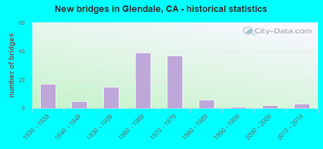
- New bridges - historical statistics
- 171930-1939
- 51940-1949
- 151950-1959
- 391960-1969
- 371970-1979
- 61980-1989
- 11990-1999
- 22000-2009
- 32010-2019

- Reconstructed bridges - Historical Statistics
- 11930-1939
- 01940-1949
- 01950-1959
- 11960-1969
- 11970-1979
- 21980-1989
- 11990-1999
- 32000-2009
- 02010-2019
- 52020-2022


- Bridge Condition - Deck
- 1.2%Very good
- 76.8%Good
- 2.4%Satisfactory
- 18.3%Fair
- 1.2%Poor

- Bridge Condition - Superstructure
- 1.2%Very good
- 92.7%Good
- 1.2%Satisfactory
- 4.9%Fair

- Bridge Condition - Substructure
- 1.2%Very good
- 92.7%Good
- 4.9%Satisfactory
- 1.2%Fair

- Bridge Condition - Channel
- 89.2%Excellent
- 8.1%Very good
- 2.7%Good
Find on map >> Show street view
Structure Number: 53 107, Location: 07-LA-005-24.30-LA (Lat: 34.119994, Lng: -118.271331), Route carried "on" structure: City street L450, Year Built: 1956, Status: Open, Structure Length: 9.16m (30.05ft), Average Daily Traffic: 43,801 (year 2010), Truck Traffic: 2%, Average Future Daily Traffic: 55,225 (year 2037), Design Load: HS 20, Features Intersected: I-5, Facility Carried by Structure: LOS FELIZ BLVD OC
Minimum Vertical Clearance: 30+ m (98+ ft), Kilometerpoint: 0.000, Lanes on structure: 6, Lanes under structure: 15, Owner: State Highway Agency, Approaching Roadway Width: 23.8m (78.1ft), Skew: 23 degrees, Material/Design: Concrete continuous, Design/Construction: Box Beam or Girders - Multiple, Number Of Spans In Main Unit: 4, Length of Maximum Span: 27.3m (89.6ft), Curb or Sidewalk Widths: Left: 2.1m (6.9ft), Right: 2.1m (6.9ft), Curb-To-Curb Width: 23.8m (78.1ft), Out-to-Out Width: 29.8m (97.8ft)
Condition: Deck: Good, Superstructure: Good, Substructure: Good, Operating Rating: 44.7 metric tons, Method Used To Determine Operating Rating: Load and Resistance Factor Rating (LRFR) rating reported by rating factor(RF) method using HL-93 loadings, Inventory Rating: 31.4 metric tons, Method Used To Determine Inventory Rating: Load and Resistance Factor Rating (LRFR) rating reported by rating factor(RF) method using HL-93 loadings, Structural Evaluation: Better than present minimum criteria, Deck Geometry: Somewhat better than minimum adequacy, Underclear: Meets minimum limits, Approach Roadway Alignment: Equal to present desirable criteria, Designated Inspection Frequency: Every 24 months, Inspection Date: July 2020, Deck Structure Type: Concrete Cast-file-Place
Find on map >> Show street view
Structure Number: 53 1075, Location: 07-LA-005-27.07-GNDL (Lat: 34.155300, Lng: -118.289144), Route carried "on" structure: Interstate 5, Year Built: 1957, Year Reconstructed: 2020, Status: Open, Structure Length: 19.45m (63.81ft), Average Daily Traffic: 264,292 (year 2010), Truck Traffic: 7%, Average Future Daily Traffic: 299,186 (year 2037), Design Load: HS 20, Features Intersected: LOS ANGELES RI,SR 134 WB
Minimum Vertical Clearance: 30+ m (98+ ft), Kilometerpoint: 27.070, Lanes on structure: 10, Lanes under structure: 4, Base Highway Network: Yes (, Subroute: 1), Owner: State Highway Agency, Approaching Roadway Width: 48.5m (159.1ft), Skew: 34 degrees, Material/Design: Steel, Design/Construction: Stringer/Multi-beam, Number Of Spans In Main Unit: 5, Length of Maximum Span: 43.9m (144.0ft), Curb-To-Curb Width: 48.5m (159.1ft), Out-to-Out Width: 50.0m (164.0ft)
Condition: Deck: Good, Superstructure: Good, Substructure: Good, Channel: Very good, Operating Rating: 54.4 metric tons, Method Used To Determine Operating Rating: Load and Resistance Factor Rating (LRFR) rating reported by rating factor(RF) method using HL-93 loadings, Inventory Rating: 42.1 metric tons, Method Used To Determine Inventory Rating: Load and Resistance Factor Rating (LRFR) rating reported by rating factor(RF) method using HL-93 loadings, Structural Evaluation: Better than present minimum criteria, Deck Geometry: Superior to present desirable criteria, Underclear: Meets minimum limits, Waterway Adequacy: Equal to present desirable criteria, Approach Roadway Alignment: Equal to present desirable criteria, Designated Inspection Frequency: Every 24 months, Other Special Inspection Frequency: Every 48 months, Inspection Date: September 2020, Other Special Inspection Date: April 2018, Deck Structure Type: Concrete Cast-file-Place
Find on map >> Show street view
Structure Number: 53 1077, Location: 07-LA-005-27.54-GNDL (Lat: 34.161319, Lng: -118.292975), Route carried "on" structure: Interstate 5, Year Built: 1957, Year Reconstructed: 2020, Status: Open, Structure Length: 3.19m (10.47ft), Average Daily Traffic: 241,215 (year 2010), Truck Traffic: 8%, Average Future Daily Traffic: 301,032 (year 2037), Design Load: HS 20, Features Intersected: SONORA AVE
Minimum Vertical Clearance: 30+ m (98+ ft), Kilometerpoint: 27.540, Lanes on structure: 10, Lanes under structure: 4, Base Highway Network: Yes (, Subroute: 1), Owner: State Highway Agency, Approaching Roadway Width: 54.0m (177.2ft), Skew: 32 degrees, Material/Design: Steel, Design/Construction: Stringer/Multi-beam, Number Of Spans In Main Unit: 1, Length of Maximum Span: 30.9m (101.4ft), Curb-To-Curb Width: 54.0m (177.2ft), Out-to-Out Width: 55.8m (183.1ft)
Condition: Deck: Good, Superstructure: Good, Substructure: Good, Operating Rating: 68.7 metric tons, Method Used To Determine Operating Rating: Field evaluation and documented engineering judgment, Inventory Rating: 39.9 metric tons, Method Used To Determine Inventory Rating: Field evaluation and documented engineering judgment, Structural Evaluation: Better than present minimum criteria, Deck Geometry: Superior to present desirable criteria, Underclear: Somewhat better than minimum adequacy, Approach Roadway Alignment: Equal to present desirable criteria, Designated Inspection Frequency: Every 24 months, Inspection Date: September 2020, Deck Structure Type: Concrete Cast-file-Place
Find on map >> Show street view
Structure Number: 53 1077L, Location: 07-LA-005-27.54-GNDL (Lat: 34.161125, Lng: -118.293194), Route carried "on" structure: Interstate 5, Year Built: 1957, Year Reconstructed: 2020, Status: Open, Structure Length: 3.19m (10.47ft), Average Daily Traffic: 119,286 (year 2011), Truck Traffic: 8%, Average Future Daily Traffic: 116,502 (year 2037), Design Load: HS 20, Features Intersected: SONORA AVE
Minimum Vertical Clearance: 30+ m (98+ ft), Kilometerpoint: 27.540, Lanes on structure: 5, Lanes under structure: 4, Base Highway Network: Yes (, Subroute: 1), Owner: State Highway Agency, Approaching Roadway Width: 27.0m (88.6ft), Skew: 2 degrees, Material/Design: Steel, Design/Construction: Stringer/Multi-beam, Number Of Spans In Main Unit: 1, Length of Maximum Span: 30.9m (101.4ft), Curb-To-Curb Width: 27.0m (88.6ft), Out-to-Out Width: 27.9m (91.5ft)
Condition: Deck: Good, Superstructure: Good, Substructure: Good, Operating Rating: 68.7 metric tons, Method Used To Determine Operating Rating: Field evaluation and documented engineering judgment, Inventory Rating: 39.9 metric tons, Method Used To Determine Inventory Rating: Field evaluation and documented engineering judgment, Structural Evaluation: Better than present minimum criteria, Deck Geometry: Superior to present desirable criteria, Underclear: Somewhat better than minimum adequacy, Approach Roadway Alignment: Equal to present desirable criteria, Designated Inspection Frequency: Every 24 months, Inspection Date: September 2020, Deck Structure Type: Concrete Cast-file-Place
Find on map >> Show street view
Structure Number: 53 1077R, Location: 07-LA-005-27.54-GNDL (Lat: 34.161319, Lng: -118.292975), Route carried "on" structure: Interstate 5, Year Built: 1957, Year Reconstructed: 2020, Status: Open, Structure Length: 3.19m (10.47ft), Average Daily Traffic: 119,286 (year 2011), Truck Traffic: 8%, Average Future Daily Traffic: 116,502 (year 2037), Design Load: HS 20, Features Intersected: SONORA AVE
Minimum Vertical Clearance: 30+ m (98+ ft), Kilometerpoint: 27.540, Lanes on structure: 5, Lanes under structure: 4, Base Highway Network: Yes (, Subroute: 1), Owner: State Highway Agency, Approaching Roadway Width: 27.0m (88.6ft), Skew: 2 degrees, Material/Design: Steel, Design/Construction: Stringer/Multi-beam, Number Of Spans In Main Unit: 1, Length of Maximum Span: 30.9m (101.4ft), Curb-To-Curb Width: 27.0m (88.6ft), Out-to-Out Width: 27.9m (91.5ft)
Condition: Deck: Good, Superstructure: Good, Substructure: Good, Operating Rating: 68.7 metric tons, Method Used To Determine Operating Rating: Field evaluation and documented engineering judgment, Inventory Rating: 39.9 metric tons, Method Used To Determine Inventory Rating: Field evaluation and documented engineering judgment, Structural Evaluation: Better than present minimum criteria, Deck Geometry: Superior to present desirable criteria, Underclear: Somewhat better than minimum adequacy, Approach Roadway Alignment: Equal to present desirable criteria, Designated Inspection Frequency: Every 24 months, Inspection Date: September 2020, Deck Structure Type: Concrete Cast-file-Place
Find on map >> Show street view
Structure Number: 53 1079, Location: 07-LA-005-27.84-GNDL (Lat: 34.164656, Lng: -118.296286), Route carried "on" structure: Interstate 5, Year Built: 1957, Year Reconstructed: 2020, Status: Open, Structure Length: 3.25m (10.66ft), Average Daily Traffic: 238,572 (year 2011), Truck Traffic: 8%, Average Future Daily Traffic: 233,004 (year 2037), Design Load: HS 20, Features Intersected: WESTERN AVE
Minimum Vertical Clearance: 30+ m (98+ ft), Kilometerpoint: 27.840, Lanes on structure: 8, Lanes under structure: 4, Base Highway Network: Yes (, Subroute: 1), Owner: State Highway Agency, Approaching Roadway Width: 44.5m (146.0ft), Skew: 30 degrees, Material/Design: Steel, Design/Construction: Stringer/Multi-beam, Number Of Spans In Main Unit: 2, Length of Maximum Span: 15.6m (51.2ft), Curb-To-Curb Width: 44.5m (146.0ft), Out-to-Out Width: 46.0m (150.9ft)
Condition: Deck: Good, Superstructure: Good, Substructure: Good, Operating Rating: 78.4 metric tons, Method Used To Determine Operating Rating: Load Factor (LF), Inventory Rating: 47.0 metric tons, Method Used To Determine Inventory Rating: Load Factor (LF), Structural Evaluation: Better than present minimum criteria, Deck Geometry: Superior to present desirable criteria, Underclear: Meets minimum limits, Approach Roadway Alignment: Equal to present desirable criteria, Designated Inspection Frequency: Every 24 months, Other Special Inspection Frequency: Every 48 months, Inspection Date: November 2020, Other Special Inspection Date: Febuary 2020, Deck Structure Type: Concrete Cast-file-Place
Find on map >> Show street view
Structure Number: 53 1079K, Location: 07-LA-005-27.84-GNDL (Lat: 34.164372, Lng: -118.296581), Route carried "on" structure: Bypass Interstate 5, Year Built: 1957, Year Reconstructed: 1992, Status: Open, Structure Length: 3.25m (10.66ft), Average Daily Traffic: 12,856 (year 2011), Truck Traffic: 2%, Average Future Daily Traffic: 15,768 (year 2037), Design Load: HS 20, Features Intersected: WESTERN AVE
Minimum Vertical Clearance: 30+ m (98+ ft), Kilometerpoint: 27.840, Lanes on structure: 2, Lanes under structure: 4, Base Highway Network: Yes (, Subroute: 1), Owner: State Highway Agency, Approaching Roadway Width: 8.5m (27.9ft), Material/Design: Steel, Design/Construction: Stringer/Multi-beam, Number Of Spans In Main Unit: 2, Length of Maximum Span: 15.6m (51.2ft), Curb-To-Curb Width: 8.5m (27.9ft), Out-to-Out Width: 9.4m (30.8ft)
Condition: Deck: Good, Superstructure: Good, Substructure: Good, Operating Rating: 76.8 metric tons, Method Used To Determine Operating Rating: Load Factor (LF), Inventory Rating: 46.0 metric tons, Method Used To Determine Inventory Rating: Load Factor (LF), Structural Evaluation: Better than present minimum criteria, Deck Geometry: High priority of replacement, Underclear: Meets minimum limits, Approach Roadway Alignment: Equal to present desirable criteria, Designated Inspection Frequency: Every 48 months, Other Special Inspection Frequency: Every 48 months, Inspection Date: November 2020, Other Special Inspection Date: Febuary 2020, Deck Structure Type: Concrete Cast-file-Place
Find on map >> Show street view
Structure Number: 53 1079S, Location: 07-LA-005-27.84-GNDL (Lat: 34.164781, Lng: -118.296150), Route carried "on" structure: Ramp Interstate 5, Year Built: 1957, Year Reconstructed: 2012, Status: Open, Structure Length: 3.25m (10.66ft), Average Daily Traffic: 5,740 (year 2011), Truck Traffic: 2%, Average Future Daily Traffic: 7,019 (year 2037), Design Load: HS 20, Features Intersected: WESTERN AVE
Minimum Vertical Clearance: 30+ m (98+ ft), Kilometerpoint: 27.840, Lanes on structure: 3, Lanes under structure: 4, Base Highway Network: Yes (, Subroute: 1), Owner: State Highway Agency, Approaching Roadway Width: 13.4m (44.0ft), Material/Design: Steel, Design/Construction: Stringer/Multi-beam, Number Of Spans In Main Unit: 2, Length of Maximum Span: 15.6m (51.2ft), Curb-To-Curb Width: 13.4m (44.0ft), Out-to-Out Width: 14.3m (46.9ft)
Condition: Deck: Good, Superstructure: Good, Substructure: Good, Operating Rating: 76.8 metric tons, Method Used To Determine Operating Rating: Load Factor (LF), Inventory Rating: 46.0 metric tons, Method Used To Determine Inventory Rating: Load Factor (LF), Structural Evaluation: Better than present minimum criteria, Deck Geometry: Somewhat better than minimum adequacy, Underclear: Meets minimum limits, Approach Roadway Alignment: Equal to present desirable criteria, Designated Inspection Frequency: Every 48 months, Other Special Inspection Frequency: Every 48 months, Inspection Date: November 2020, Other Special Inspection Date: Febuary 2020, Deck Structure Type: Concrete Cast-file-Place
Find on map >> Show street view
Structure Number: 53 1106, Location: 07-LA-005S-25.29-GNDL (Lat: 34.141797, Lng: -118.269092), Route carried "on" structure: City street , Year Built: 1957, Status: Open, Structure Length: 2.79m (9.15ft), Average Daily Traffic: 14,000 (year 1998), Truck Traffic: 3%, Average Future Daily Traffic: 21,803 (year 2044), Design Load: H 20, Features Intersected: I-5 SUPPLEMENTAL ROUTE, Facility Carried by Structure: SAN FERNANDO RD
Minimum Vertical Clearance: 30+ m (98+ ft), Kilometerpoint: 0.000, Lanes on structure: 5, Lanes under structure: 4, Owner: State Highway Agency, Approaching Roadway Width: 22.6m (74.1ft), Skew: 2 degrees, Material/Design: Concrete continuous, Design/Construction: Slab, Number Of Spans In Main Unit: 2, Number Of Approach Spans: 1, Length of Maximum Span: 13.8m (45.3ft), Curb or Sidewalk Widths: Left: 0.3m (1.0ft), Right: 2.1m (6.9ft), Curb-To-Curb Width: 22.6m (74.1ft), Out-to-Out Width: 25.2m (82.7ft)
Condition: Deck: Good, Superstructure: Good, Substructure: Good, Operating Rating: 79.4 metric tons, Method Used To Determine Operating Rating: Load Factor (LF), Inventory Rating: 47.6 metric tons, Method Used To Determine Inventory Rating: Load Factor (LF), Structural Evaluation: Better than present minimum criteria, Deck Geometry: Equal to present minimum criteria, Underclear: High priority of corrective action, Approach Roadway Alignment: Equal to present minimum criteria, Designated Inspection Frequency: Every 48 months, Inspection Date: Febuary 2022, Deck Structure Type: Concrete Cast-file-Place
Find on map >> Show street view
Structure Number: 53 1741, Location: 07-LA-110-5.90-LA (Lat: 33.815292, Lng: -118.287178), Route carried "on" structure: Interstate 110, Year Built: 1962, Status: Open, Structure Length: 0.67m (2.20ft), Average Daily Traffic: 199,500 (year 2015), Truck Traffic: 9%, Average Future Daily Traffic: 233,826 (year 2037), Features Intersected: GALAVAN STORM DRAIN
Minimum Vertical Clearance: 30+ m (98+ ft), Kilometerpoint: 5.900, Lanes on structure: 8, Base Highway Network: Yes (Inventory Route: 1, Subroute: 1), Owner: State Highway Agency, Approaching Roadway Width: 40.2m (131.9ft), Skew: 34 degrees, Material/Design: Concrete, Design/Construction: Culvert, Number Of Spans In Main Unit: 1, Length of Maximum Span: 3.7m (12.1ft), Curb-To-Curb Width: 40.2m (131.9ft), Out-to-Out Width: 40.2m (131.9ft)
Condition: Channel: Excellent, Culverts: Good, Operating Rating: 54.1 metric tons, Method Used To Determine Operating Rating: Field evaluation and documented engineering judgment, Inventory Rating: 32.4 metric tons, Method Used To Determine Inventory Rating: Field evaluation and documented engineering judgment, Structural Evaluation: Better than present minimum criteria, Deck Geometry: Superior to present desirable criteria, Waterway Adequacy: Superior to present desirable criteria, Approach Roadway Alignment: Equal to present desirable criteria, Designated Inspection Frequency: Every 24 months, Inspection Date: March 2020
Find on map >> Show street view
Structure Number: 53 1744, Location: 07-LA-134-R6.18-GNDL (Lat: 34.154503, Lng: -118.271406), Route carried "on" structure: State highway 134, Year Built: 1968, Year Reconstructed: 2005, Status: Open, Structure Length: 4.70m (15.42ft), Average Daily Traffic: 242,000 (year 2017), Truck Traffic: 8%, Average Future Daily Traffic: 273,692 (year 2040), Design Load: HS 20, Features Intersected: CONCORD STREET
Minimum Vertical Clearance: 30+ m (98+ ft), Kilometerpoint: 6.180, Lanes on structure: 11, Lanes under structure: 5, Base Highway Network: Yes (Inventory Route: 1, Subroute: 1), Owner: State Highway Agency, Approaching Roadway Width: 55.6m (182.4ft), Skew: 31 degrees, Material/Design: Concrete continuous, Design/Construction: Box Beam or Girders - Multiple, Number Of Spans In Main Unit: 3, Length of Maximum Span: 25.7m (84.3ft), Curb-To-Curb Width: 55.6m (182.4ft), Out-to-Out Width: 58.0m (190.3ft)
Condition: Deck: Fair, Superstructure: Good, Substructure: Good, Operating Rating: 54.1 metric tons, Method Used To Determine Operating Rating: Assigned rating based on Load Factor Design (LFD) reported in metric tons, Inventory Rating: 32.4 metric tons, Method Used To Determine Inventory Rating: Assigned rating based on Load Factor Design (LFD) reported in metric tons, Structural Evaluation: Better than present minimum criteria, Deck Geometry: Superior to present desirable criteria, Underclear: Somewhat better than minimum adequacy, Approach Roadway Alignment: Equal to present desirable criteria, Designated Inspection Frequency: Every 24 months, Inspection Date: December 2021, Deck Structure Type: Concrete Cast-file-Place
Find on map >> Show street view
Structure Number: 53 1746, Location: 07-LA-134-R6.57-GNDL (Lat: 34.155983, Lng: -118.264758), Route carried "on" structure: State highway 134, Year Built: 1967, Status: Open, Structure Length: 4.45m (14.60ft), Average Daily Traffic: 240,000 (year 2017), Truck Traffic: 8%, Average Future Daily Traffic: 273,692 (year 2040), Design Load: HS 20, Features Intersected: PACIFIC AVE
Minimum Vertical Clearance: 30+ m (98+ ft), Kilometerpoint: 6.570, Lanes on structure: 10, Lanes under structure: 5, Base Highway Network: Yes (Inventory Route: 1, Subroute: 1), Owner: State Highway Agency, Approaching Roadway Width: 43.9m (144.0ft), Skew: 32 degrees, Material/Design: Concrete continuous, Design/Construction: Box Beam or Girders - Multiple, Number Of Spans In Main Unit: 3, Length of Maximum Span: 26.2m (86.0ft), Curb-To-Curb Width: 43.9m (144.0ft), Out-to-Out Width: 44.8m (147.0ft)
Condition: Deck: Poor, Superstructure: Good, Substructure: Good, Operating Rating: 69.0 metric tons, Method Used To Determine Operating Rating: Load Factor (LF), Inventory Rating: 41.1 metric tons, Method Used To Determine Inventory Rating: Load Factor (LF), Structural Evaluation: Better than present minimum criteria, Deck Geometry: Better than present minimum criteria, Underclear: Meets minimum limits, Approach Roadway Alignment: Equal to present desirable criteria, Length Of Structure Improvement: 4.45m (14.60ft), Designated Inspection Frequency: Every 24 months, Inspection Date: December 2021, Bridge Improvement Cost: $1,990,000, Roadway Improvement Cost: $398,000, Total Project Cost: $3,343,000 ( Estimate for 2020), Deck Structure Type: Concrete Cast-file-Place
Find on map >> Show street view
Structure Number: 53 1748, Location: 07-LA-134-R6.96-GNDL (Lat: 34.156642, Lng: -118.258128), Route carried "on" structure: City street Q283, Year Built: 1968, Year Reconstructed: 1996, Status: Open, Structure Length: 5.58m (18.31ft), Average Daily Traffic: 26,000 (year 2015), Truck Traffic: 1%, Average Future Daily Traffic: 28,000 (year 2040), Design Load: HS 20, Features Intersected: STATE ROUTE 134, Facility Carried by Structure: CENTRAL AVE
Minimum Vertical Clearance: 30+ m (98+ ft), Kilometerpoint: 6.960, Lanes on structure: 6, Lanes under structure: 11, Owner: State Highway Agency, Approaching Roadway Width: 22.6m (74.1ft), Material/Design: Concrete continuous, Design/Construction: Box Beam or Girders - Multiple, Number Of Spans In Main Unit: 2, Length of Maximum Span: 31.0m (101.7ft), Curb or Sidewalk Widths: Left: 2.4m (7.9ft), Right: 3.6m (11.8ft), Curb-To-Curb Width: 22.6m (74.1ft), Out-to-Out Width: 29.3m (96.1ft)
Condition: Deck: Good, Superstructure: Good, Substructure: Good, Operating Rating: 54.1 metric tons, Method Used To Determine Operating Rating: Assigned rating based on Load Factor Design (LFD) reported in metric tons, Inventory Rating: 32.4 metric tons, Method Used To Determine Inventory Rating: Assigned rating based on Load Factor Design (LFD) reported in metric tons, Structural Evaluation: Better than present minimum criteria, Deck Geometry: Meets minimum limits, Underclear: High priority of corrective action, Approach Roadway Alignment: Equal to present desirable criteria, Designated Inspection Frequency: Every 24 months, Inspection Date: December 2021, Deck Structure Type: Concrete Cast-file-Place
Find on map >> Show street view
Structure Number: 53 1749, Location: 07-LA-134-R7.13-GNDL (Lat: 34.156664, Lng: -118.255269), Route carried "on" structure: City street L311, Year Built: 1968, Status: Open, Structure Length: 6.52m (21.39ft), Average Daily Traffic: 38,000 (year 2015), Truck Traffic: 1%, Average Future Daily Traffic: 40,000 (year 2040), Design Load: HS 20, Features Intersected: STATE ROUTE 134, Facility Carried by Structure: BRAND BLVD
Minimum Vertical Clearance: 30+ m (98+ ft), Kilometerpoint: 0.000, Lanes on structure: 9, Lanes under structure: 10, Owner: State Highway Agency, Approaching Roadway Width: 30.5m (100.1ft), Material/Design: Concrete continuous, Design/Construction: Box Beam or Girders - Multiple, Number Of Spans In Main Unit: 2, Length of Maximum Span: 32.5m (106.6ft), Curb or Sidewalk Widths: Left: 3.0m (9.8ft), Right: 3.0m (9.8ft), Curb-To-Curb Width: 30.5m (100.1ft), Out-to-Out Width: 37.2m (122.0ft)
Condition: Deck: Good, Superstructure: Fair, Substructure: Good, Operating Rating: 44.4 metric tons, Method Used To Determine Operating Rating: Load and Resistance Factor Rating (LRFR) rating reported by rating factor(RF) method using HL-93 loadings, Inventory Rating: 34.0 metric tons, Method Used To Determine Inventory Rating: Load and Resistance Factor Rating (LRFR) rating reported by rating factor(RF) method using HL-93 loadings, Structural Evaluation: Somewhat better than minimum adequacy, Deck Geometry: High priority of replacement, Underclear: High priority of corrective action, Approach Roadway Alignment: Equal to present desirable criteria, Designated Inspection Frequency: Every 24 months, Inspection Date: December 2021, Deck Structure Type: Concrete Cast-file-Place
Find on map >> Show street view
Structure Number: 53 1751, Location: 07-LA-134-R7.40-GNDL (Lat: 34.156636, Lng: -118.250383), Route carried "on" structure: City street Q411, Year Built: 1965, Status: Open, Structure Length: 5.82m (19.09ft), Average Daily Traffic: 4,900 (year 2017), Truck Traffic: 2%, Average Future Daily Traffic: 7,418 (year 2042), Design Load: HS 20, Features Intersected: STATE ROUTE 134, Facility Carried by Structure: JACKSON ST
Minimum Vertical Clearance: 30+ m (98+ ft), Kilometerpoint: 0.000, Lanes on structure: 2, Lanes under structure: 12, Owner: State Highway Agency, Approaching Roadway Width: 15.8m (51.8ft), Material/Design: Concrete continuous, Design/Construction: Box Beam or Girders - Multiple, Number Of Spans In Main Unit: 2, Length of Maximum Span: 29.0m (95.1ft), Curb or Sidewalk Widths: Left: 2.1m (6.9ft), Right: 2.1m (6.9ft), Curb-To-Curb Width: 15.8m (51.8ft), Out-to-Out Width: 20.7m (67.9ft)
Condition: Deck: Good, Superstructure: Good, Substructure: Good, Operating Rating: 48.6 metric tons, Method Used To Determine Operating Rating: Load and Resistance Factor Rating (LRFR) rating reported by rating factor(RF) method using HL-93 loadings, Inventory Rating: 37.6 metric tons, Method Used To Determine Inventory Rating: Load and Resistance Factor Rating (LRFR) rating reported by rating factor(RF) method using HL-93 loadings, Structural Evaluation: Better than present minimum criteria, Deck Geometry: Superior to present desirable criteria, Underclear: High priority of corrective action, Approach Roadway Alignment: Equal to present desirable criteria, Designated Inspection Frequency: Every 48 months, Inspection Date: December 2021, Deck Structure Type: Concrete Cast-file-Place
Find on map >> Show street view
Structure Number: 53 1752, Location: 07-LA-134-R7.60-GNDL (Lat: 34.156700, Lng: -118.246936), Route carried "on" structure: City street , Year Built: 1968, Status: Open, Structure Length: 6.95m (22.80ft), Average Daily Traffic: 7,000 (year 2015), Truck Traffic: 2%, Average Future Daily Traffic: 7,300 (year 2040), Design Load: HS 20, Features Intersected: STATE ROUTE 134, Facility Carried by Structure: GENEVA ST
Minimum Vertical Clearance: 30+ m (98+ ft), Kilometerpoint: 0.000, Lanes on structure: 2, Lanes under structure: 12, Owner: State Highway Agency, Approaching Roadway Width: 15.8m (51.8ft), Material/Design: Concrete continuous, Design/Construction: Box Beam or Girders - Multiple, Number Of Spans In Main Unit: 2, Length of Maximum Span: 34.4m (112.9ft), Curb or Sidewalk Widths: Left: 2.1m (6.9ft), Right: 2.1m (6.9ft), Curb-To-Curb Width: 15.8m (51.8ft), Out-to-Out Width: 20.7m (67.9ft)
Condition: Deck: Good, Superstructure: Good, Substructure: Good, Operating Rating: 36.6 metric tons, Method Used To Determine Operating Rating: Load and Resistance Factor Rating (LRFR) rating reported by rating factor(RF) method using HL-93 loadings, Inventory Rating: 28.2 metric tons, Method Used To Determine Inventory Rating: Load and Resistance Factor Rating (LRFR) rating reported by rating factor(RF) method using HL-93 loadings, Structural Evaluation: Better than present minimum criteria, Deck Geometry: Superior to present desirable criteria, Underclear: High priority of corrective action, Approach Roadway Alignment: Equal to present desirable criteria, Designated Inspection Frequency: Every 24 months, Inspection Date: December 2021, Deck Structure Type: Concrete Cast-file-Place
Find on map >> Show street view
Structure Number: 53 1863, Location: 07-LA-134-R8.23-GNDL (Lat: 34.152467, Lng: -118.237100), Route carried "on" structure: State highway 134, Year Built: 1968, Status: Open, Structure Length: 9.91m (32.51ft), Average Daily Traffic: 226,000 (year 2017), Truck Traffic: 3%, Average Future Daily Traffic: 253,571 (year 2042), Design Load: HS 20, Features Intersected: VERDUGO RD
Minimum Vertical Clearance: 30+ m (98+ ft), Kilometerpoint: 8.230, Lanes on structure: 12, Lanes under structure: 4, Base Highway Network: Yes (Inventory Route: 1, Subroute: 1), Owner: State Highway Agency, Approaching Roadway Width: 47.5m (155.8ft), Skew: 25 degrees, Material/Design: Concrete continuous, Design/Construction: Box Beam or Girders - Multiple, Number Of Spans In Main Unit: 4, Length of Maximum Span: 28.0m (91.9ft), Curb-To-Curb Width: 47.5m (155.8ft), Out-to-Out Width: 48.8m (160.1ft)
Condition: Deck: Fair, Superstructure: Good, Substructure: Good, Operating Rating: 64.2 metric tons, Method Used To Determine Operating Rating: Load Factor (LF), Inventory Rating: 38.6 metric tons, Method Used To Determine Inventory Rating: Load Factor (LF), Structural Evaluation: Better than present minimum criteria, Deck Geometry: Meets minimum limits, Underclear: Meets minimum limits, Approach Roadway Alignment: Equal to present desirable criteria, Designated Inspection Frequency: Every 24 months, Inspection Date: December 2021, Deck Structure Type: Concrete Cast-file-Place
Find on map >> Show street view
Structure Number: 53 1866, Location: 07-LA-134-R8.35-GNDL (Lat: 34.151600, Lng: -118.235925), Route carried "on" structure: State highway 134, Year Built: 1967, Status: Open, Structure Length: 6.83m (22.41ft), Average Daily Traffic: 234,000 (year 2017), Truck Traffic: 3%, Average Future Daily Traffic: 253,000 (year 2042), Design Load: HS 20, Features Intersected: CHEVY CHASE DRIVE
Minimum Vertical Clearance: 30+ m (98+ ft), Kilometerpoint: 8.350, Lanes on structure: 12, Lanes under structure: 5, Base Highway Network: Yes (Inventory Route: 1, Subroute: 1), Owner: State Highway Agency, Approaching Roadway Width: 47.5m (155.8ft), Skew: 33 degrees, Material/Design: Concrete continuous, Design/Construction: Box Beam or Girders - Multiple, Number Of Spans In Main Unit: 3, Length of Maximum Span: 38.1m (125.0ft), Curb-To-Curb Width: 47.5m (155.8ft), Out-to-Out Width: 48.8m (160.1ft)
Condition: Deck: Good, Superstructure: Good, Substructure: Good, Operating Rating: 83.6 metric tons, Method Used To Determine Operating Rating: Load Factor (LF), Inventory Rating: 50.2 metric tons, Method Used To Determine Inventory Rating: Load Factor (LF), Structural Evaluation: Better than present minimum criteria, Deck Geometry: Meets minimum limits, Underclear: Meets minimum limits, Approach Roadway Alignment: Equal to present desirable criteria, Designated Inspection Frequency: Every 24 months, Inspection Date: December 2021, Deck Structure Type: Concrete Cast-file-Place
Find on map >> Show street view
Structure Number: 53 1875, Location: 07-LA-134-R7.87-GNDL (Lat: 34.156117, Lng: -118.242172), Route carried "on" structure: City street , Year Built: 1968, Status: Open, Structure Length: 5.83m (19.13ft), Average Daily Traffic: 39,400 (year 2015), Truck Traffic: 1%, Average Future Daily Traffic: 42,000 (year 2040), Design Load: HS 20, Features Intersected: STATE ROUTE 134 & RAMPS, Facility Carried by Structure: GLENDALE AVE
Minimum Vertical Clearance: 30+ m (98+ ft), Kilometerpoint: 0.000, Lanes on structure: 7, Lanes under structure: 12, Owner: State Highway Agency, Approaching Roadway Width: 24.3m (79.7ft), Skew: 20 degrees, Material/Design: Concrete continuous, Design/Construction: Box Beam or Girders - Multiple, Number Of Spans In Main Unit: 2, Length of Maximum Span: 29.4m (96.5ft), Curb or Sidewalk Widths: Left: 3.0m (9.8ft), Right: 3.0m (9.8ft), Curb-To-Curb Width: 24.3m (79.7ft), Out-to-Out Width: 31.1m (102.0ft)
Condition: Deck: Fair, Superstructure: Fair, Substructure: Good, Operating Rating: 54.4 metric tons, Method Used To Determine Operating Rating: Load and Resistance Factor Rating (LRFR) rating reported by rating factor(RF) method using HL-93 loadings, Inventory Rating: 41.8 metric tons, Method Used To Determine Inventory Rating: Load and Resistance Factor Rating (LRFR) rating reported by rating factor(RF) method using HL-93 loadings, Structural Evaluation: Somewhat better than minimum adequacy, Deck Geometry: High priority of replacement, Underclear: High priority of corrective action, Approach Roadway Alignment: Equal to present desirable criteria, Designated Inspection Frequency: Every 24 months, Inspection Date: December 2021, Deck Structure Type: Concrete Cast-file-Place
Find on map >> Show street view
Structure Number: 53 1878, Location: 07-LA-134-R8.56-GNDL (Lat: 34.149442, Lng: -118.232697), Route carried "on" structure: State highway 134, Year Built: 1967, Year Reconstructed: 2007, Status: Open, Structure Length: 5.32m (17.45ft), Average Daily Traffic: 234,000 (year 2017), Truck Traffic: 3%, Average Future Daily Traffic: 254,224 (year 2042), Design Load: HS 20, Features Intersected: SINCLAIR AVE
Minimum Vertical Clearance: 30+ m (98+ ft), Kilometerpoint: 8.560, Lanes on structure: 11, Lanes under structure: 2, Base Highway Network: Yes (Inventory Route: 1, Subroute: 1), Owner: State Highway Agency, Approaching Roadway Width: 48.0m (157.5ft), Skew: 33 degrees, Material/Design: Concrete continuous, Design/Construction: Box Beam or Girders - Multiple, Number Of Spans In Main Unit: 3, Length of Maximum Span: 26.3m (86.3ft), Curb-To-Curb Width: 48.0m (157.5ft), Out-to-Out Width: 49.4m (162.1ft)
Condition: Deck: Fair, Superstructure: Good, Substructure: Good, Operating Rating: 58.0 metric tons, Method Used To Determine Operating Rating: Load Factor (LF), Inventory Rating: 34.7 metric tons, Method Used To Determine Inventory Rating: Load Factor (LF), Structural Evaluation: Better than present minimum criteria, Deck Geometry: Equal to present desirable criteria, Underclear: Equal to present minimum criteria, Approach Roadway Alignment: Equal to present desirable criteria, Designated Inspection Frequency: Every 24 months, Inspection Date: December 2021, Deck Structure Type: Concrete Cast-file-Place
Find on map >> Show street view
Structure Number: 53 1878F, Location: 07-LA-002-R18.94-GNDL (Lat: 34.149711, Lng: -118.232228), Route carried "on" structure: Ramp State highway 2, Year Built: 1967, Status: Open, Structure Length: 5.18m (16.99ft), Average Daily Traffic: 18,905 (year 2019), Truck Traffic: 2%, Average Future Daily Traffic: 25,229 (year 2038), Design Load: HS 20, Features Intersected: SINCLAIR AVE
Minimum Vertical Clearance: 30+ m (98+ ft), Kilometerpoint: 18.940, Lanes on structure: 2, Lanes under structure: 2, Base Highway Network: Yes (, Subroute: 1), Owner: State Highway Agency, Approaching Roadway Width: 8.5m (27.9ft), Skew: 9 degrees, Material/Design: Concrete continuous, Design/Construction: Box Beam or Girders - Multiple, Number Of Spans In Main Unit: 3, Length of Maximum Span: 26.5m (86.9ft), Curb-To-Curb Width: 8.5m (27.9ft), Out-to-Out Width: 10.4m (34.1ft)
Condition: Deck: Good, Superstructure: Good, Substructure: Good, Operating Rating: 68.7 metric tons, Method Used To Determine Operating Rating: Load Factor (LF), Inventory Rating: 41.1 metric tons, Method Used To Determine Inventory Rating: Load Factor (LF), Structural Evaluation: Better than present minimum criteria, Deck Geometry: High priority of corrective action, Underclear: High priority of corrective action, Approach Roadway Alignment: Superior to present desirable criteria, Designated Inspection Frequency: Every 48 months, Inspection Date: December 2021, Deck Structure Type: Concrete Cast-file-Place
Find on map >> Show street view
Structure Number: 53 1884, Location: 07-LA-134-R8.81-GNDL (Lat: 34.147633, Lng: -118.229150), Route carried "on" structure: State highway 134, Year Built: 1967, Status: Open, Structure Length: 4.97m (16.31ft), Average Daily Traffic: 227,378 (year 2017), Truck Traffic: 3%, Average Future Daily Traffic: 253,571 (year 2042), Design Load: HS 20, Features Intersected: HARVEY DR
Minimum Vertical Clearance: 30+ m (98+ ft), Kilometerpoint: 8.810, Lanes on structure: 10, Lanes under structure: 5, Base Highway Network: Yes (Inventory Route: 1, Subroute: 1), Owner: State Highway Agency, Approaching Roadway Width: 42.1m (138.1ft), Skew: 30 degrees, Material/Design: Concrete continuous, Design/Construction: Box Beam or Girders - Multiple, Number Of Spans In Main Unit: 3, Length of Maximum Span: 25.0m (82.0ft), Curb-To-Curb Width: 42.1m (138.1ft), Out-to-Out Width: 43.3m (142.1ft)
Condition: Deck: Fair, Superstructure: Good, Substructure: Good, Operating Rating: 39.5 metric tons, Method Used To Determine Operating Rating: Load and Resistance Factor Rating (LRFR) rating reported by rating factor(RF) method using HL-93 loadings, Inventory Rating: 30.5 metric tons, Method Used To Determine Inventory Rating: Load and Resistance Factor Rating (LRFR) rating reported by rating factor(RF) method using HL-93 loadings, Structural Evaluation: Better than present minimum criteria, Deck Geometry: Equal to present minimum criteria, Underclear: High priority of corrective action, Approach Roadway Alignment: Equal to present desirable criteria, Designated Inspection Frequency: Every 24 months, Inspection Date: December 2021, Deck Structure Type: Concrete Cast-file-Place
Find on map >> Show street view
Structure Number: 53 1884G, Location: 07-LA-002-R18.83-GNDL (Lat: 34.147656, Lng: -118.227489), Route carried "on" structure: Ramp State highway 2, Year Built: 1967, Status: Open, Structure Length: 12.13m (39.80ft), Average Daily Traffic: 9,600 (year 2019), Truck Traffic: 2%, Average Future Daily Traffic: 12,824 (year 2038), Design Load: HS 20, Features Intersected: HARVEY DR & W134-OFFRAMP
Minimum Vertical Clearance: 30+ m (98+ ft), Kilometerpoint: 18.830, Lanes on structure: 2, Lanes under structure: 5, Base Highway Network: Yes (, Subroute: 1), Owner: State Highway Agency, Approaching Roadway Width: 8.5m (27.9ft), Material/Design: Concrete continuous, Design/Construction: Box Beam or Girders - Multiple, Number Of Spans In Main Unit: 3, Length of Maximum Span: 47.2m (154.9ft), Curb-To-Curb Width: 8.5m (27.9ft), Out-to-Out Width: 10.4m (34.1ft)
Condition: Deck: Good, Superstructure: Good, Substructure: Good, Operating Rating: 38.2 metric tons, Method Used To Determine Operating Rating: Load and Resistance Factor Rating (LRFR) rating reported by rating factor(RF) method using HL-93 loadings, Inventory Rating: 29.5 metric tons, Method Used To Determine Inventory Rating: Load and Resistance Factor Rating (LRFR) rating reported by rating factor(RF) method using HL-93 loadings, Structural Evaluation: Better than present minimum criteria, Deck Geometry: High priority of corrective action, Underclear: Somewhat better than minimum adequacy, Approach Roadway Alignment: Equal to present desirable criteria, Designated Inspection Frequency: Every 24 months, Inspection Date: December 2021, Deck Structure Type: Concrete Cast-file-Place
Find on map >> Show street view
Structure Number: 53 1893, Location: 07-LA-002-R20.05-GNDL (Lat: 34.164239, Lng: -118.225325), Route carried "on" structure: City street Q288, Year Built: 1975, Status: Open, Structure Length: 7.07m (23.20ft), Average Daily Traffic: 4,000 (year 2014), Truck Traffic: 2%, Average Future Daily Traffic: 6,167 (year 2044), Design Load: HS 20+Mod, Features Intersected: SR 2, Facility Carried by Structure: MOUNTAIN ST
Minimum Vertical Clearance: 30+ m (98+ ft), Kilometerpoint: 0.000, Lanes on structure: 6, Lanes under structure: 8, Owner: State Highway Agency, Approaching Roadway Width: 23.8m (78.1ft), Material/Design: Concrete continuous, Design/Construction: Box Beam or Girders - Multiple, Number Of Spans In Main Unit: 2, Length of Maximum Span: 38.1m (125.0ft), Curb or Sidewalk Widths: Left: 2.4m (7.9ft), Right: 2.4m (7.9ft), Curb-To-Curb Width: 23.8m (78.1ft), Out-to-Out Width: 28.7m (94.2ft)
Condition: Deck: Good, Superstructure: Good, Substructure: Good, Operating Rating: 79.1 metric tons, Method Used To Determine Operating Rating: Load and Resistance Factor Rating (LRFR) rating reported by rating factor(RF) method using HL-93 loadings, Inventory Rating: 60.9 metric tons, Method Used To Determine Inventory Rating: Load and Resistance Factor Rating (LRFR) rating reported by rating factor(RF) method using HL-93 loadings, Structural Evaluation: Better than present minimum criteria, Deck Geometry: Somewhat better than minimum adequacy, Underclear: Meets minimum limits, Approach Roadway Alignment: Superior to present desirable criteria, Designated Inspection Frequency: Every 24 months, Inspection Date: January 2022, Deck Structure Type: Concrete Cast-file-Place
Find on map >> Show street view
Structure Number: 53 1894, Location: 07-LA-002-R20.57-GNDL (Lat: 34.171467, Lng: -118.222375), Route carried "on" structure: State highway 2, Year Built: 1978, Status: Open, Structure Length: 6.49m (21.29ft), Average Daily Traffic: 115,000 (year 2014), Truck Traffic: 5%, Average Future Daily Traffic: 125,767 (year 2044), Design Load: HS 20, Features Intersected: SHERER LANE UC
Minimum Vertical Clearance: 30+ m (98+ ft), Kilometerpoint: 20.570, Lanes on structure: 9, Lanes under structure: 2, Base Highway Network: Yes (, Subroute: 1), Owner: State Highway Agency, Approaching Roadway Width: 48.2m (158.1ft), Skew: 32 degrees, Material/Design: Concrete continuous, Design/Construction: Box Beam or Girders - Multiple, Number Of Spans In Main Unit: 3, Length of Maximum Span: 26.8m (87.9ft), Curb-To-Curb Width: 47.5m (155.8ft), Out-to-Out Width: 49.2m (161.4ft)
Condition: Deck: Good, Superstructure: Good, Substructure: Good, Operating Rating: 52.2 metric tons, Method Used To Determine Operating Rating: Load and Resistance Factor Rating (LRFR) rating reported by rating factor(RF) method using HL-93 loadings, Inventory Rating: 40.2 metric tons, Method Used To Determine Inventory Rating: Load and Resistance Factor Rating (LRFR) rating reported by rating factor(RF) method using HL-93 loadings, Structural Evaluation: Better than present minimum criteria, Deck Geometry: Superior to present desirable criteria, Underclear: Meets minimum limits, Approach Roadway Alignment: Equal to present desirable criteria, Designated Inspection Frequency: Every 48 months, Inspection Date: January 2022, Deck Structure Type: Concrete Cast-file-Place, Wearing Surface/Protective System: Wearing Surface: Monolithic Concrete
Find on map >> Show street view
Structure Number: 53 1901, Location: 07-LA-002-R18.92-GNDL (Lat: 34.148797, Lng: -118.227856), Route carried "on" structure: City street L489, Year Built: 1967, Status: Open, Structure Length: 2.26m (7.41ft), Average Daily Traffic: 14,700 (year 2014), Truck Traffic: 1%, Average Future Daily Traffic: 22,514 (year 2043), Design Load: H 20, Features Intersected: S2-W134 CONNECTOR RAMP, Facility Carried by Structure: HARVEY DRIVE
Minimum Vertical Clearance: 30+ m (98+ ft), Kilometerpoint: 0.000, Lanes on structure: 4, Lanes under structure: 2, Owner: State Highway Agency, Approaching Roadway Width: 18.3m (60.0ft), Skew: 5 degrees, Material/Design: Concrete, Design/Construction: Box Beam or Girders - Multiple, Number Of Spans In Main Unit: 1, Length of Maximum Span: 22.3m (73.2ft), Curb or Sidewalk Widths: Left: 1.5m (4.9ft), Right: 1.5m (4.9ft), Curb-To-Curb Width: 19.5m (64.0ft), Out-to-Out Width: 23.2m (76.1ft)
Condition: Deck: Good, Superstructure: Good, Substructure: Good, Operating Rating: 92.3 metric tons, Method Used To Determine Operating Rating: Load Factor (LF), Inventory Rating: 55.7 metric tons, Method Used To Determine Inventory Rating: Load Factor (LF), Structural Evaluation: Better than present minimum criteria, Deck Geometry: Better than present minimum criteria, Underclear: Meets minimum limits, Approach Roadway Alignment: Superior to present desirable criteria, Designated Inspection Frequency: Every 48 months, Inspection Date: December 2021, Deck Structure Type: Concrete Cast-file-Place
Find on map >> Show street view
Structure Number: 53 1907G, Location: 07-LA-134-R8.57-GNDL (Lat: 34.149278, Lng: -118.232850), Route carried "on" structure: Ramp State highway 134, Year Built: 1967, Year Reconstructed: 1978, Status: Open, Structure Length: 98.12m (321.92ft), Average Daily Traffic: 29,987 (year 2017), Truck Traffic: 3%, Average Future Daily Traffic: 31,083 (year 2040), Design Load: H 20, Features Intersected: ROUTES 134 & 2,3 STREETS
Minimum Vertical Clearance: 30+ m (98+ ft), Kilometerpoint: 8.570, Lanes on structure: 2, Lanes under structure: 31, Base Highway Network: Yes (Inventory Route: 1, Subroute: 1), Owner: State Highway Agency, Approaching Roadway Width: 9.8m (32.2ft), Skew: 9 degrees, Material/Design: Prestressed concrete continuous, Design/Construction: Box Beam or Girders - Multiple, Number Of Spans In Main Unit: 28, Length of Maximum Span: 56.8m (186.4ft), Curb-To-Curb Width: 9.8m (32.2ft), Out-to-Out Width: 10.4m (34.1ft)
Condition: Deck: Good, Superstructure: Good, Substructure: Good, Operating Rating: 83.6 metric tons, Method Used To Determine Operating Rating: Load Factor (LF), Inventory Rating: 50.2 metric tons, Method Used To Determine Inventory Rating: Load Factor (LF), Structural Evaluation: Better than present minimum criteria, Deck Geometry: Equal to present minimum criteria, Underclear: Meets minimum limits, Approach Roadway Alignment: Equal to present desirable criteria, Designated Inspection Frequency: Every 24 months, Inspection Date: December 2021, Deck Structure Type: Concrete Cast-file-Place
Find on map >> Show street view
Structure Number: 53 194, Location: 07-LA-057-R6.82-POM (Lat: 34.052825, Lng: -117.802403), Route carried "on" structure: State highway 57, Year Built: 1972, Status: Open, Structure Length: 4.63m (15.19ft), Average Daily Traffic: 158,000 (year 2012), Truck Traffic: 5%, Average Future Daily Traffic: 146,359 (year 2040), Design Load: HS 20, Features Intersected: POMONA BLVD
Minimum Vertical Clearance: 30+ m (98+ ft), Kilometerpoint: 6.820, Lanes on structure: 10, Lanes under structure: 4, Base Highway Network: Yes (, Subroute: 1), Owner: State Highway Agency, Approaching Roadway Width: 51.8m (169.9ft), Skew: 32 degrees, Material/Design: Prestressed concrete, Design/Construction: Box Beam or Girders - Multiple, Number Of Spans In Main Unit: 1, Length of Maximum Span: 45.7m (149.9ft), Curb-To-Curb Width: 51.2m (168.0ft), Out-to-Out Width: 52.4m (171.9ft)
Condition: Deck: Good, Superstructure: Fair, Substructure: Good, Operating Rating: 62.2 metric tons, Method Used To Determine Operating Rating: Load and Resistance Factor Rating (LRFR) rating reported by rating factor(RF) method using HL-93 loadings, Inventory Rating: 40.2 metric tons, Method Used To Determine Inventory Rating: Load and Resistance Factor Rating (LRFR) rating reported by rating factor(RF) method using HL-93 loadings, Structural Evaluation: Somewhat better than minimum adequacy, Deck Geometry: Superior to present desirable criteria, Underclear: Meets minimum limits, Approach Roadway Alignment: Superior to present desirable criteria, Designated Inspection Frequency: Every 24 months, Inspection Date: August 2020, Deck Structure Type: Concrete Cast-file-Place
Find on map >> Show street view
Structure Number: 53 1946, Location: 07-LA-002-R19.05-GNDL (Lat: 34.150028, Lng: -118.225703), Route carried "on" structure: City street Q438, Year Built: 1978, Status: Open, Structure Length: 6.80m (22.31ft), Average Daily Traffic: 8,000 (year 2019), Truck Traffic: 1%, Average Future Daily Traffic: 9,460 (year 2038), Design Load: HS 20, Features Intersected: ROUTE 2, Facility Carried by Structure: HOLLY DR OC
Minimum Vertical Clearance: 30+ m (98+ ft), Kilometerpoint: 0.000, Lanes on structure: 4, Lanes under structure: 8, Owner: State Highway Agency, Approaching Roadway Width: 19.5m (64.0ft), Material/Design: Prestressed concrete continuous, Design/Construction: Box Beam or Girders - Multiple, Number Of Spans In Main Unit: 2, Length of Maximum Span: 33.8m (110.9ft), Curb or Sidewalk Widths: Left: 2.1m (6.9ft), Right: 2.1m (6.9ft), Curb-To-Curb Width: 19.5m (64.0ft), Out-to-Out Width: 24.4m (80.1ft)
Condition: Deck: Good, Superstructure: Good, Substructure: Good, Operating Rating: 51.8 metric tons, Method Used To Determine Operating Rating: Load and Resistance Factor Rating (LRFR) rating reported by rating factor(RF) method using HL-93 loadings, Inventory Rating: 35.6 metric tons, Method Used To Determine Inventory Rating: Load and Resistance Factor Rating (LRFR) rating reported by rating factor(RF) method using HL-93 loadings, Structural Evaluation: Better than present minimum criteria, Deck Geometry: Better than present minimum criteria, Underclear: Meets minimum limits, Approach Roadway Alignment: Equal to present desirable criteria, Designated Inspection Frequency: Every 24 months, Inspection Date: December 2021, Deck Structure Type: Concrete Cast-file-Place
Find on map >> Show street view
Structure Number: 53 1947, Location: 07-LA-002-R19.05-GNDL (Lat: 34.150297, Lng: -118.226569), Route carried "on" structure: City street Q438, Year Built: 1978, Status: Open, Structure Length: 6.10m (20.01ft), Average Daily Traffic: 8,000 (year 2019), Truck Traffic: 1%, Average Future Daily Traffic: 9,460 (year 2038), Design Load: HS 20, Features Intersected: W2-W&E134 CONNECTOR RMPS, Facility Carried by Structure: HOLLY DRIVE
Minimum Vertical Clearance: 30+ m (98+ ft), Kilometerpoint: 0.000, Lanes on structure: 4, Lanes under structure: 3, Owner: State Highway Agency, Approaching Roadway Width: 19.5m (64.0ft), Material/Design: Concrete continuous, Design/Construction: Box Beam or Girders - Multiple, Number Of Spans In Main Unit: 2, Length of Maximum Span: 30.2m (99.1ft), Curb or Sidewalk Widths: Left: 2.1m (6.9ft), Right: 2.1m (6.9ft), Curb-To-Curb Width: 19.5m (64.0ft), Out-to-Out Width: 24.4m (80.1ft)
Condition: Deck: Good, Superstructure: Good, Substructure: Good, Operating Rating: 83.3 metric tons, Method Used To Determine Operating Rating: Load and Resistance Factor Rating (LRFR) rating reported by rating factor(RF) method using HL-93 loadings, Inventory Rating: 60.3 metric tons, Method Used To Determine Inventory Rating: Load and Resistance Factor Rating (LRFR) rating reported by rating factor(RF) method using HL-93 loadings, Structural Evaluation: Better than present minimum criteria, Deck Geometry: Better than present minimum criteria, Underclear: Meets minimum limits, Approach Roadway Alignment: Equal to present desirable criteria, Designated Inspection Frequency: Every 48 months, Inspection Date: December 2021, Deck Structure Type: Concrete Cast-file-Place
Find on map >> Show street view
Structure Number: 53 1948F, Location: 07-LA-134-R9.04-GNDL (Lat: 34.149617, Lng: -118.224514), Route carried "on" structure: Ramp State highway 134, Year Built: 1978, Status: Open, Structure Length: 4.38m (14.37ft), Average Daily Traffic: 3,780 (year 2017), Truck Traffic: 3%, Average Future Daily Traffic: 5,100 (year 2040), Design Load: HS 20, Features Intersected: HOLLY DR
Minimum Vertical Clearance: 30+ m (98+ ft), Kilometerpoint: 9.040, Lanes on structure: 1, Lanes under structure: 4, Owner: State Highway Agency, Approaching Roadway Width: 7.3m (24.0ft), Material/Design: Prestressed concrete, Design/Construction: Box Beam or Girders - Multiple, Number Of Spans In Main Unit: 1, Length of Maximum Span: 43.2m (141.7ft), Curb-To-Curb Width: 7.3m (24.0ft), Out-to-Out Width: 8.4m (27.6ft)
Condition: Deck: Good, Superstructure: Good, Substructure: Good, Operating Rating: 51.2 metric tons, Method Used To Determine Operating Rating: Load and Resistance Factor Rating (LRFR) rating reported by rating factor(RF) method using HL-93 loadings, Inventory Rating: 31.4 metric tons, Method Used To Determine Inventory Rating: Load and Resistance Factor Rating (LRFR) rating reported by rating factor(RF) method using HL-93 loadings, Structural Evaluation: Better than present minimum criteria, Deck Geometry: Better than present minimum criteria, Underclear: Meets minimum limits, Approach Roadway Alignment: Better than present minimum criteria, Designated Inspection Frequency: Every 24 months, Inspection Date: December 2021, Deck Structure Type: Concrete Cast-file-Place
Find on map >> Show street view
Structure Number: 53 1967, Location: 07-LA-002-R19.18-GNDL (Lat: 34.151819, Lng: -118.224578), Route carried "on" structure: State highway 2, Year Built: 1978, Status: Open, Structure Length: 6.46m (21.19ft), Average Daily Traffic: 115,000 (year 2019), Truck Traffic: 5%, Average Future Daily Traffic: 120,042 (year 2038), Design Load: HS 20, Features Intersected: GLENOAKS BLVD
Minimum Vertical Clearance: 30+ m (98+ ft), Kilometerpoint: 19.180, Lanes on structure: 10, Lanes under structure: 2, Base Highway Network: Yes (, Subroute: 1), Owner: State Highway Agency, Approaching Roadway Width: 49.7m (163.1ft), Skew: 30 degrees, Material/Design: Concrete continuous, Design/Construction: Box Beam or Girders - Multiple, Number Of Spans In Main Unit: 3, Length of Maximum Span: 26.8m (87.9ft), Curb-To-Curb Width: 49.7m (163.1ft), Out-to-Out Width: 51.5m (169.0ft)
Condition: Deck: Satisfactory, Superstructure: Good, Substructure: Good, Operating Rating: 99.8 metric tons, Method Used To Determine Operating Rating: Load Factor (LF), Inventory Rating: 65.1 metric tons, Method Used To Determine Inventory Rating: Load Factor (LF), Structural Evaluation: Better than present minimum criteria, Deck Geometry: Superior to present desirable criteria, Underclear: Equal to present minimum criteria, Approach Roadway Alignment: Superior to present desirable criteria, Designated Inspection Frequency: Every 48 months, Inspection Date: December 2021, Deck Structure Type: Concrete Cast-file-Place
Find on map >> Show street view
Structure Number: 53 1967F, Location: 07-LA-002-R19.18-GNDL (Lat: 34.152028, Lng: -118.225194), Route carried "on" structure: Ramp State highway 2, Year Built: 1978, Status: Open, Structure Length: 5.70m (18.70ft), Average Daily Traffic: 18,800 (year 2019), Truck Traffic: 4%, Average Future Daily Traffic: 25,123 (year 2038), Design Load: HS 20, Features Intersected: GLENOAKS BLVD
Minimum Vertical Clearance: 30+ m (98+ ft), Kilometerpoint: 19.180, Lanes on structure: 3, Lanes under structure: 2, Base Highway Network: Yes (, Subroute: 1), Owner: State Highway Agency, Approaching Roadway Width: 11.6m (38.1ft), Material/Design: Concrete continuous, Design/Construction: Box Beam or Girders - Multiple, Number Of Spans In Main Unit: 3, Length of Maximum Span: 26.8m (87.9ft), Curb-To-Curb Width: 11.6m (38.1ft), Out-to-Out Width: 12.8m (42.0ft)
Condition: Deck: Good, Superstructure: Good, Substructure: Good, Operating Rating: 60.6 metric tons, Method Used To Determine Operating Rating: Load and Resistance Factor Rating (LRFR) rating reported by rating factor(RF) method using HL-93 loadings, Inventory Rating: 46.7 metric tons, Method Used To Determine Inventory Rating: Load and Resistance Factor Rating (LRFR) rating reported by rating factor(RF) method using HL-93 loadings, Structural Evaluation: Better than present minimum criteria, Deck Geometry: High priority of replacement, Underclear: Equal to present minimum criteria, Approach Roadway Alignment: Superior to present desirable criteria, Designated Inspection Frequency: Every 48 months, Inspection Date: December 2021, Deck Structure Type: Concrete Cast-file-Place
Find on map >> Show street view
Structure Number: 53 1968, Location: 07-LA-002-R19.39-GNDL (Lat: 34.155086, Lng: -118.224003), Route carried "on" structure: State highway 2, Year Built: 1978, Status: Open, Structure Length: 12.16m (39.90ft), Average Daily Traffic: 115,000 (year 2014), Truck Traffic: 5%, Average Future Daily Traffic: 128,303 (year 2044), Design Load: HS 20, Features Intersected: CHEVY CHASE DR
Minimum Vertical Clearance: 30+ m (98+ ft), Kilometerpoint: 19.390, Lanes on structure: 12, Lanes under structure: 2, Base Highway Network: Yes (, Subroute: 1), Owner: State Highway Agency, Approaching Roadway Width: 55.5m (182.1ft), Skew: 31 degrees, Material/Design: Concrete continuous, Design/Construction: Box Beam or Girders - Multiple, Number Of Spans In Main Unit: 3, Length of Maximum Span: 46.9m (153.9ft), Curb-To-Curb Width: 55.5m (182.1ft), Out-to-Out Width: 57.3m (188.0ft)
Condition: Deck: Good, Superstructure: Good, Substructure: Good, Operating Rating: 99.8 metric tons, Method Used To Determine Operating Rating: Load Factor (LF), Inventory Rating: 84.6 metric tons, Method Used To Determine Inventory Rating: Load Factor (LF), Structural Evaluation: Better than present minimum criteria, Deck Geometry: Superior to present desirable criteria, Underclear: Equal to present minimum criteria, Approach Roadway Alignment: Better than present minimum criteria, Designated Inspection Frequency: Every 24 months, Inspection Date: January 2022, Deck Structure Type: Concrete Cast-file-Place
Find on map >> Show street view
Structure Number: 53 2220G, Location: 07-LA-002-R23.00-GNDL (Lat: 34.205128, Lng: -118.218314), Route carried "on" structure: Ramp State highway 2, Year Built: 1972, Status: Open, Structure Length: 15.93m (52.26ft), Average Daily Traffic: 27,400 (year 2014), Truck Traffic: 5%, Average Future Daily Traffic: 38,325 (year 2044), Design Load: HS 20, Features Intersected: VERDUGO BL & W210-W2 RP
Minimum Vertical Clearance: 5.41m (17.75ft), Kilometerpoint: 23.000, Lanes on structure: 3, Lanes under structure: 6, Base Highway Network: Yes (, Subroute: 1), Owner: State Highway Agency, Approaching Roadway Width: 15.5m (50.9ft), Skew: 9 degrees, Material/Design: Concrete continuous, Design/Construction: Box Beam or Girders - Multiple, Number Of Spans In Main Unit: 5, Length of Maximum Span: 38.8m (127.3ft), Curb-To-Curb Width: 15.5m (50.9ft), Out-to-Out Width: 16.2m (53.1ft)
Condition: Deck: Fair, Superstructure: Good, Substructure: Good, Operating Rating: 99.8 metric tons, Method Used To Determine Operating Rating: Load Factor (LF), Inventory Rating: 62.2 metric tons, Method Used To Determine Inventory Rating: Load Factor (LF), Structural Evaluation: Better than present minimum criteria, Deck Geometry: Superior to present desirable criteria, Underclear: Equal to present minimum criteria, Approach Roadway Alignment: Equal to present desirable criteria, Designated Inspection Frequency: Every 24 months, Inspection Date: January 2022, Deck Structure Type: Concrete Cast-file-Place
Find on map >> Show street view
Structure Number: 53 2231L, Location: 07-LA-002-R22.94-GNDL (Lat: 34.204786, Lng: -118.218931), Route carried "on" structure: State highway 2, Year Built: 1972, Status: Open, Structure Length: 41.09m (134.81ft), Average Daily Traffic: 57,500 (year 2014), Truck Traffic: 5%, Average Future Daily Traffic: 64,152 (year 2044), Design Load: HS 20, Features Intersected: ROUTE 210, VERDUGO, CONN
Minimum Vertical Clearance: 30+ m (98+ ft), Kilometerpoint: 22.940, Lanes on structure: 2, Lanes under structure: 23, Base Highway Network: Yes (, Subroute: 1), Owner: State Highway Agency, Approaching Roadway Width: 9.8m (32.2ft), Material/Design: Prestressed concrete continuous, Design/Construction: Box Beam or Girders - Multiple, Number Of Spans In Main Unit: 2, Number Of Approach Spans: 7, Length of Maximum Span: 68.9m (226.0ft), Curb-To-Curb Width: 9.8m (32.2ft), Out-to-Out Width: 10.4m (34.1ft)
Condition: Deck: Fair, Superstructure: Good, Substructure: Good, Operating Rating: 54.1 metric tons, Method Used To Determine Operating Rating: Assigned rating based on Load Factor Design (LFD) reported in metric tons, Inventory Rating: 32.4 metric tons, Method Used To Determine Inventory Rating: Assigned rating based on Load Factor Design (LFD) reported in metric tons, Structural Evaluation: Better than present minimum criteria, Deck Geometry: Meets minimum limits, Underclear: High priority of corrective action, Approach Roadway Alignment: Equal to present desirable criteria, Designated Inspection Frequency: Every 24 months, Inspection Date: January 2022, Deck Structure Type: Concrete Cast-file-Place
Find on map >> Show street view
Structure Number: 53 2231R, Location: 07-LA-002-R22.97-GNDL (Lat: 34.205136, Lng: -118.218133), Route carried "on" structure: State highway 2, Year Built: 1972, Status: Open, Structure Length: 34.50m (113.19ft), Average Daily Traffic: 57,500 (year 2014), Truck Traffic: 5%, Average Future Daily Traffic: 62,884 (year 2044), Design Load: HS 20, Features Intersected: RTE 210, VERDUGO BL, CON
Minimum Vertical Clearance: 30+ m (98+ ft), Kilometerpoint: 22.970, Lanes on structure: 2, Lanes under structure: 16, Base Highway Network: Yes (, Subroute: 1), Owner: State Highway Agency, Approaching Roadway Width: 9.8m (32.2ft), Material/Design: Concrete continuous, Design/Construction: Box Beam or Girders - Multiple, Number Of Spans In Main Unit: 9, Length of Maximum Span: 47.2m (154.9ft), Curb-To-Curb Width: 9.8m (32.2ft), Out-to-Out Width: 10.4m (34.1ft)
Condition: Deck: Good, Superstructure: Good, Substructure: Good, Operating Rating: 82.3 metric tons, Method Used To Determine Operating Rating: Load Factor (LF), Inventory Rating: 49.6 metric tons, Method Used To Determine Inventory Rating: Load Factor (LF), Structural Evaluation: Better than present minimum criteria, Deck Geometry: Meets minimum limits, Underclear: Meets minimum limits, Approach Roadway Alignment: Equal to present desirable criteria, Designated Inspection Frequency: Every 24 months, Inspection Date: January 2022, Deck Structure Type: Concrete Cast-file-Place
Find on map >> Show street view
Structure Number: 53 2242, Location: 07-LA-002-R22.69-GNDL (Lat: 34.200758, Lng: -118.218856), Route carried "on" structure: State highway 2, Year Built: 1972, Status: Open, Structure Length: 3.93m (12.89ft), Average Daily Traffic: 115,000 (year 2014), Truck Traffic: 5%, Average Future Daily Traffic: 125,767 (year 2044), Design Load: HS 20, Features Intersected: STANCREST DRIVE
Minimum Vertical Clearance: 30+ m (98+ ft), Kilometerpoint: 22.690, Lanes on structure: 14, Lanes under structure: 2, Base Highway Network: Yes (, Subroute: 1), Owner: State Highway Agency, Approaching Roadway Width: 82.3m (270.0ft), Skew: 31 degrees, Material/Design: Prestressed concrete, Design/Construction: Box Beam or Girders - Multiple, Number Of Spans In Main Unit: 1, Length of Maximum Span: 39.3m (128.9ft), Curb-To-Curb Width: 81.7m (268.0ft), Out-to-Out Width: 82.9m (272.0ft)
Condition: Deck: Fair, Superstructure: Good, Substructure: Good, Operating Rating: 49.2 metric tons, Method Used To Determine Operating Rating: Load and Resistance Factor Rating (LRFR) rating reported by rating factor(RF) method using HL-93 loadings, Inventory Rating: 33.4 metric tons, Method Used To Determine Inventory Rating: Load and Resistance Factor Rating (LRFR) rating reported by rating factor(RF) method using HL-93 loadings, Structural Evaluation: Better than present minimum criteria, Deck Geometry: Superior to present desirable criteria, Underclear: Equal to present minimum criteria, Approach Roadway Alignment: Equal to present desirable criteria, Designated Inspection Frequency: Every 24 months, Inspection Date: January 2022, Deck Structure Type: Concrete Cast-file-Place
Find on map >> Show street view
Structure Number: 53 2282, Location: 07-LA-210-R16.16-GNDL (Lat: 34.228308, Lng: -118.257678), Route carried "on" structure: Interstate 210, Year Built: 1972, Status: Open, Structure Length: 4.33m (14.21ft), Average Daily Traffic: 156,000 (year 2017), Truck Traffic: 6%, Average Future Daily Traffic: 160,105 (year 2041), Design Load: HS 20, Features Intersected: DUNSMORE AVE
Minimum Vertical Clearance: 30+ m (98+ ft), Kilometerpoint: 16.160, Lanes on structure: 10, Lanes under structure: 2, Base Highway Network: Yes (Inventory Route: 2, Subroute: 1), Owner: State Highway Agency, Approaching Roadway Width: 56.1m (184.1ft), Skew: 33 degrees, Material/Design: Prestressed concrete, Design/Construction: Box Beam or Girders - Multiple, Number Of Spans In Main Unit: 1, Length of Maximum Span: 42.8m (140.4ft), Curb-To-Curb Width: 56.1m (184.1ft), Out-to-Out Width: 57.3m (188.0ft)
Condition: Deck: Fair, Superstructure: Good, Substructure: Good, Operating Rating: 99.8 metric tons, Method Used To Determine Operating Rating: Load Factor (LF), Inventory Rating: 32.4 metric tons, Method Used To Determine Inventory Rating: Load Factor (LF), Structural Evaluation: Better than present minimum criteria, Deck Geometry: Superior to present desirable criteria, Underclear: Somewhat better than minimum adequacy, Approach Roadway Alignment: Equal to present desirable criteria, Designated Inspection Frequency: Every 24 months, Inspection Date: August 2020, Deck Structure Type: Concrete Cast-file-Place
Find on map >> Show street view
Structure Number: 53 2301, Location: 07-LA-014-R75.06 (Lat: 34.792172, Lng: -118.170547), Route carried "on" structure: State highway 14, Year Built: 1968, Status: Open, Structure Length: 1.31m (4.30ft), Average Daily Traffic: 33,500 (year 2019), Truck Traffic: 7%, Average Future Daily Traffic: 57,640 (year 2041), Features Intersected: AVE C DRAIN 4
Minimum Vertical Clearance: 30+ m (98+ ft), Kilometerpoint: 75.060, Lanes on structure: 4, Base Highway Network: Yes (, Subroute: 1), Owner: State Highway Agency, Approaching Roadway Width: 34.9m (114.5ft), Skew: 10 degrees, Material/Design: Concrete continuous, Design/Construction: Culvert, Number Of Spans In Main Unit: 4, Length of Maximum Span: 3.0m (9.8ft), Curb-To-Curb Width: 34.9m (114.5ft), Out-to-Out Width: 58.5m (191.9ft)
Condition: Channel: Very good, Culverts: Good, Operating Rating: 54.1 metric tons, Method Used To Determine Operating Rating: Field evaluation and documented engineering judgment, Inventory Rating: 32.4 metric tons, Method Used To Determine Inventory Rating: Field evaluation and documented engineering judgment, Structural Evaluation: Better than present minimum criteria, Deck Geometry: Superior to present desirable criteria, Waterway Adequacy: Equal to present desirable criteria, Approach Roadway Alignment: Superior to present desirable criteria, Designated Inspection Frequency: Every 48 months, Inspection Date: May 2021
Find on map >> Show street view
Structure Number: 53 2306, Location: 07-LA-210-R15.62-GNDL (Lat: 34.230947, Lng: -118.266447), Route carried "on" structure: Interstate 210, Year Built: 1972, Status: Open, Structure Length: 4.36m (14.30ft), Average Daily Traffic: 156,000 (year 2017), Truck Traffic: 9%, Average Future Daily Traffic: 187,091 (year 2041), Design Load: HS 20, Features Intersected: LOWELL AVE
Minimum Vertical Clearance: 30+ m (98+ ft), Kilometerpoint: 15.620, Lanes on structure: 9, Lanes under structure: 4, Base Highway Network: Yes (Inventory Route: 2, Subroute: 1), Owner: State Highway Agency, Approaching Roadway Width: 53.6m (175.9ft), Skew: 31 degrees, Material/Design: Prestressed concrete, Design/Construction: Box Beam or Girders - Multiple, Number Of Spans In Main Unit: 1, Length of Maximum Span: 43.2m (141.7ft), Curb-To-Curb Width: 53.6m (175.9ft), Out-to-Out Width: 54.9m (180.1ft)
Condition: Deck: Good, Superstructure: Good, Substructure: Good, Operating Rating: 57.7 metric tons, Method Used To Determine Operating Rating: Load and Resistance Factor Rating (LRFR) rating reported by rating factor(RF) method using HL-93 loadings, Inventory Rating: 36.0 metric tons, Method Used To Determine Inventory Rating: Load and Resistance Factor Rating (LRFR) rating reported by rating factor(RF) method using HL-93 loadings, Structural Evaluation: Better than present minimum criteria, Deck Geometry: Superior to present desirable criteria, Underclear: Somewhat better than minimum adequacy, Approach Roadway Alignment: Equal to present desirable criteria, Designated Inspection Frequency: Every 24 months, Inspection Date: August 2020, Deck Structure Type: Concrete Cast-file-Place