Bridge Statistics for Glenolden, Pennsylvania (PA)
Condition, Traffic, Stress, Structural Evaluation, Project Costs
- National Bridge Inventory (NBI) Statistics
- 10Number of bridges
- 49ft / 14.5mTotal length
- $2,553,000Total costs
- 45,977Total average daily traffic
- 2,301Total average daily truck traffic
- 55,111Total future (year 2022) average daily traffic
- National Bridge Inventory (NBI) Registered Bridges for Glenolden
- No street view available for this location
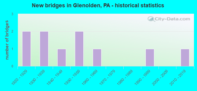
- New bridges - historical statistics
- 21920-1929
- 21930-1939
- 11940-1949
- 21950-1959
- 11960-1969
- 11990-1999
- 12010-2019
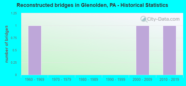
- Reconstructed bridges - Historical Statistics
- 11960-1969
- 01970-1979
- 01980-1989
- 01990-1999
- 12000-2009
- 12010-2019
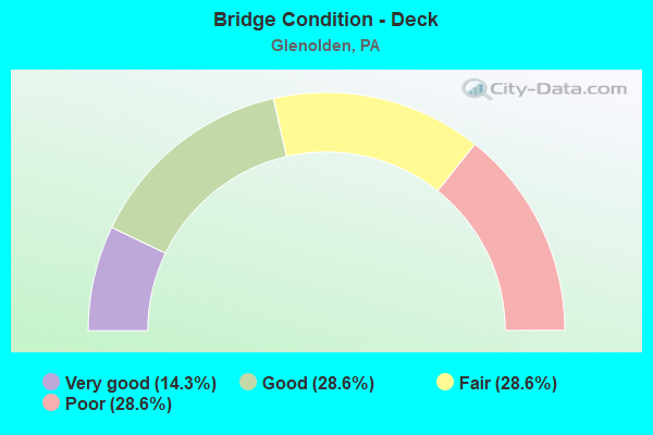
- Bridge Condition - Deck
- 14.3%Very good
- 28.6%Good
- 28.6%Fair
- 28.6%Poor
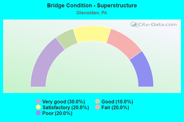
- Bridge Condition - Superstructure
- 30.0%Very good
- 10.0%Good
- 20.0%Satisfactory
- 20.0%Fair
- 20.0%Poor
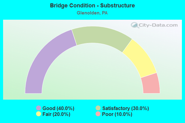
- Bridge Condition - Substructure
- 40.0%Good
- 30.0%Satisfactory
- 20.0%Fair
- 10.0%Poor
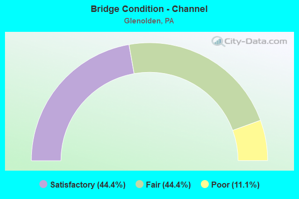
- Bridge Condition - Channel
- 44.4%Satisfactory
- 44.4%Fair
- 11.1%Poor
Find on map >> Show street view
Structure Number: 6479, Location: 1 MI. N. OF BENTLEY CREEK (Lat: 41.958167, Lng: -76.716372), Route carried "on" structure: State highway , Year Built: 1957, Year Reconstructed: 2010, Status: Open, Structure Length: 1.01m (3.31ft), Average Daily Traffic: 1,854 (year 2020), Truck Traffic: 5%, Average Future Daily Traffic: 2,627 (year 2032), Design Load: HL 93, Features Intersected: JUSTICE RUN, Facility Carried by Structure: SR 4013
Minimum Vertical Clearance: 30+ m (98+ ft), Kilometerpoint: 22.972, Lanes on structure: 2, Owner: State Highway Agency, Approaching Roadway Width: 6.7m (22.0ft), Skew: 2 degrees, Material/Design: Prestressed concrete, Design/Construction: Box Beam or Girders - Multiple, Number Of Spans In Main Unit: 1, Length of Maximum Span: 9.4m (30.8ft), Curb or Sidewalk Widths: Left: 0.3m (1.0ft), Right: 0.3m (1.0ft), Curb-To-Curb Width: 9.7m (31.8ft), Out-to-Out Width: 10.1m (33.1ft)
Condition: Deck: Very good, Superstructure: Very good, Substructure: Good, Channel: Fair, Operating Rating: 67.1 metric tons, Method Used To Determine Operating Rating: Load and Resistance Factor (LRFR), Inventory Rating: 51.7 metric tons, Method Used To Determine Inventory Rating: Load and Resistance Factor (LRFR), Structural Evaluation: Better than present minimum criteria, Deck Geometry: Somewhat better than minimum adequacy, Waterway Adequacy: Better than present minimum criteria, Approach Roadway Alignment: Equal to present desirable criteria, Length Of Structure Improvement: 1.00m (3.28ft), Designated Inspection Frequency: Every 48 months, Inspection Date: July 2018, Bridge Improvement Cost: $6,000, Roadway Improvement Cost: $50,000, Total Project Cost: $86,000, Wearing Surface/Protective System: Wearing Surface: Epoxy Overlay, Deck Protection: Epoxy Coated Reinforcing
Find on map >> Show street view
Structure Number: 14838, Location: 1MI.N.OF PA 420 3698 C08 (Lat: 39.893339, Lng: -75.295544), Route carried "on" structure: US 13, Year Built: 1925, Year Reconstructed: 2013, Status: Open, Structure Length: 0.85m (2.79ft), Average Daily Traffic: 14,364 (year 2020), Truck Traffic: 7%, Average Future Daily Traffic: 16,105 (year 2032), Design Load: H 20, Features Intersected: MUCKINIPATTUS CREEK, Facility Carried by Structure: CHESTER PIKE
Minimum Vertical Clearance: 30+ m (98+ ft), Kilometerpoint: 15.171, Lanes on structure: 4, Base Highway Network: Yes, Owner: State Highway Agency, Approaching Roadway Width: 17.1m (56.1ft), Material/Design: Concrete, Design/Construction: Arch - Deck, Number Of Spans In Main Unit: 1, Length of Maximum Span: 8.5m (27.9ft), Curb or Sidewalk Widths: Left: 1.5m (4.9ft), Right: 1.5m (4.9ft), Curb-To-Curb Width: 17.1m (56.1ft), Out-to-Out Width: 17.1m (56.1ft)
Condition: Superstructure: Good, Substructure: Satisfactory, Channel: Satisfactory, Operating Rating: 80.7 metric tons, Method Used To Determine Operating Rating: Field evaluation and documented engineering judgment, Inventory Rating: 48.1 metric tons, Method Used To Determine Inventory Rating: Field evaluation and documented engineering judgment, Structural Evaluation: Equal to present minimum criteria, Deck Geometry: Somewhat better than minimum adequacy, Waterway Adequacy: Equal to present minimum criteria, Approach Roadway Alignment: Equal to present desirable criteria, Length Of Structure Improvement: 1.60m (5.25ft), Designated Inspection Frequency: Every 24 months, Inspection Date: July 2021, Bridge Improvement Cost: $90,000, Roadway Improvement Cost: $265,000, Total Project Cost: $1,216,000
Find on map >> Show street view
Structure Number: 15265, Location: .1MI.N.US 13 35G09 (Lat: 39.895383, Lng: -75.296458), Route carried "on" structure: State highway , Year Built: 1965, Status: Open, Structure Length: 1.40m (4.59ft), Average Daily Traffic: 10,608 (year 2022), Truck Traffic: 3%, Average Future Daily Traffic: 12,890 (year 2032), Design Load: HS 20, Features Intersected: MUCKINIPATTIS CREEK, Facility Carried by Structure: SOUTH AVENUE
Minimum Vertical Clearance: 30+ m (98+ ft), Kilometerpoint: 0.000, Lanes on structure: 2, Owner: State Highway Agency, Approaching Roadway Width: 11.6m (38.1ft), Skew: 1 degrees, Material/Design: Prestressed concrete, Design/Construction: Box Beam or Girders - Multiple, Number Of Spans In Main Unit: 1, Length of Maximum Span: 13.1m (43.0ft), Curb or Sidewalk Widths: Left: 1.5m (4.9ft), Right: 1.5m (4.9ft), Curb-To-Curb Width: 11.8m (38.7ft), Out-to-Out Width: 15.2m (49.9ft)
Condition: Deck: Fair, Superstructure: Fair, Substructure: Fair, Channel: Satisfactory, Operating Rating: 69.9 metric tons, Method Used To Determine Operating Rating: Load Factor (LF), Inventory Rating: 35.4 metric tons, Method Used To Determine Inventory Rating: Load Factor (LF), Structural Evaluation: Somewhat better than minimum adequacy, Deck Geometry: Somewhat better than minimum adequacy, Waterway Adequacy: Equal to present minimum criteria, Approach Roadway Alignment: Equal to present desirable criteria, Length Of Structure Improvement: 2.00m (6.56ft), Designated Inspection Frequency: Every 24 months, Inspection Date: May 2020, Deck Structure Type: Concrete Cast-file-Place, Wearing Surface/Protective System: Wearing Surface: Bituminous
Find on map >> Show street view
Structure Number: 15393, Location: 0.4Mi S SR13 3698-E7 (Lat: 39.895514, Lng: -75.285094), Route carried "on" structure: County highway , Year Built: 1930, Status: Open, Structure Length: 1.86m (6.10ft), Average Daily Traffic: 2,588 (year 2017), Truck Traffic: 5%, Average Future Daily Traffic: 3,235 (year 2032), Design Load: H 20, Features Intersected: MUCKINIPATTIS CREEK, Facility Carried by Structure: ELMWOOD AVENUE
Minimum Vertical Clearance: 30+ m (98+ ft), Kilometerpoint: 0.000, Lanes on structure: 2, Owner: County Highway Agency, Approaching Roadway Width: 8.8m (28.9ft), Material/Design: Concrete, Design/Construction: Arch - Deck, Number Of Spans In Main Unit: 1, Length of Maximum Span: 18.6m (61.0ft), Curb or Sidewalk Widths: Left: 1.3m (4.3ft), Right: 1.3m (4.3ft), Curb-To-Curb Width: 11.0m (36.1ft), Out-to-Out Width: 14.6m (47.9ft)
Condition: Superstructure: Satisfactory, Substructure: Satisfactory, Channel: Fair, Inventory Rating: 99.8 metric tons, Method Used To Determine Inventory Rating: Load Factor (LF), Structural Evaluation: Equal to present minimum criteria, Deck Geometry: Somewhat better than minimum adequacy, Waterway Adequacy: Better than present minimum criteria, Approach Roadway Alignment: Equal to present desirable criteria, Length Of Structure Improvement: 1.80m (5.91ft), Designated Inspection Frequency: Every 24 months, Inspection Date: September 2019, Bridge Improvement Cost: $17,000, Roadway Improvement Cost: $50,000, Total Project Cost: $228,000
Find on map >> Show street view
Structure Number: 15395, Location: 0.1Mi SR13 3698-D8 (Lat: 39.892653, Lng: -75.292494), Route carried "on" structure: City street , Year Built: 1927, Status: Posted for load, Structure Length: 0.70m (2.30ft), Average Daily Traffic: 6,152 (year 2017), Truck Traffic: 7%, Average Future Daily Traffic: 7,690 (year 2032), Design Load: H 20, Features Intersected: MUCKINIPATTIS CREEK, Facility Carried by Structure: SOUTH AVENUE
Minimum Vertical Clearance: 30+ m (98+ ft), Kilometerpoint: 0.000, Lanes on structure: 2, Owner: County Highway Agency, Approaching Roadway Width: 10.1m (33.1ft), Material/Design: Concrete, Design/Construction: Slab, Number Of Spans In Main Unit: 1, Length of Maximum Span: 6.1m (20.0ft), Curb or Sidewalk Widths: Left: 2.2m (7.2ft), Right: 2.2m (7.2ft), Curb-To-Curb Width: 10.4m (34.1ft), Out-to-Out Width: 15.1m (49.5ft)
Condition: Deck: Fair, Superstructure: Fair, Substructure: Poor, Channel: Poor, Operating Rating: 24.5 metric tons, Method Used To Determine Operating Rating: Load Factor (LF), Inventory Rating: 14.5 metric tons, Method Used To Determine Inventory Rating: Load Factor (LF), Structural Evaluation: High priority of corrective action, Deck Geometry: Meets minimum limits, Waterway Adequacy: Equal to present minimum criteria, Approach Roadway Alignment: Equal to present desirable criteria, Bridge Posting: Required (Relationship of Operating Rating to Maximum Legal Load: > 39.9% below), Length Of Structure Improvement: 0.60m (1.97ft), Designated Inspection Frequency: Every 24 months, Other Special Inspection Frequency: Every 12 months, Inspection Date: September 2019, Other Special Inspection Date: September 2020, Bridge Improvement Cost: $12,000, Roadway Improvement Cost: $34,000, Total Project Cost: $156,000, Wearing Surface/Protective System: Wearing Surface: Bituminous
Find on map >> Show street view
Structure Number: 15415, Location: .25MI.SE.OF US-13 28-F2 (Lat: 39.895697, Lng: -75.288300), Route carried "on" structure: County highway , Year Built: 1943, Status: Open, Structure Length: 0.61m (2.00ft), Average Daily Traffic: 4,667 (year 2017), Truck Traffic: 5%, Average Future Daily Traffic: 5,133 (year 2022), Design Load: H 20, Features Intersected: MUCKINIPATTIS CREEK, Facility Carried by Structure: GLENOLDEN AVENUE
Minimum Vertical Clearance: 30+ m (98+ ft), Kilometerpoint: 0.000, Lanes on structure: 2, Owner: County Highway Agency, Approaching Roadway Width: 8.8m (28.9ft), Material/Design: Masonry, Design/Construction: Arch - Deck, Number Of Spans In Main Unit: 1, Length of Maximum Span: 6.1m (20.0ft), Curb or Sidewalk Widths: Left: 1.8m (5.9ft), Right: 1.8m (5.9ft), Curb-To-Curb Width: 9.1m (29.9ft), Out-to-Out Width: 13.9m (45.6ft)
Condition: Superstructure: Satisfactory, Substructure: Good, Channel: Fair, Operating Rating: 81.6 metric tons, Method Used To Determine Operating Rating: Field evaluation and documented engineering judgment, Inventory Rating: 49.0 metric tons, Method Used To Determine Inventory Rating: Field evaluation and documented engineering judgment, Structural Evaluation: Equal to present minimum criteria, Deck Geometry: Meets minimum limits, Waterway Adequacy: Better than present minimum criteria, Approach Roadway Alignment: Equal to present desirable criteria, Length Of Structure Improvement: 0.60m (1.97ft), Designated Inspection Frequency: Every 24 months, Inspection Date: April 2021, Bridge Improvement Cost: $11,000, Roadway Improvement Cost: $33,000, Total Project Cost: $145,000
Find on map >> Show street view
Structure Number: 15457, Location: S. CHESTER PIKE 3698-E7 (Lat: 39.898497, Lng: -75.284700), Route carried "on" structure: City street , Year Built: 1997, Status: Open, Structure Length: 4.60m (15.09ft), Average Daily Traffic: 1,000 (year 2017), Truck Traffic: 1%, Average Future Daily Traffic: 1,500 (year 2037), Design Load: HS 20, Features Intersected: AMTRAK, Facility Carried by Structure: ASHLAND AVENUE
Minimum Vertical Clearance: 30+ m (98+ ft), Kilometerpoint: 0.000, Lanes on structure: 2, Owner: City or Municipal Highway Agency, Approaching Roadway Width: 8.5m (27.9ft), Skew: 1 degrees, Material/Design: Prestressed concrete, Design/Construction: Box Beam or Girders - Single/Spread, Number Of Spans In Main Unit: 3, Length of Maximum Span: 22.6m (74.1ft), Curb or Sidewalk Widths: Left: 1.6m (5.2ft), Right: 0.2m (0.7ft), Curb-To-Curb Width: 8.5m (27.9ft), Out-to-Out Width: 11.0m (36.1ft)
Condition: Deck: Good, Superstructure: Very good, Substructure: Good, Operating Rating: 79.8 metric tons, Method Used To Determine Operating Rating: Load Factor (LF), Inventory Rating: 44.5 metric tons, Method Used To Determine Inventory Rating: Load Factor (LF), Structural Evaluation: Better than present minimum criteria, Deck Geometry: Somewhat better than minimum adequacy, Underclear: High priority of replacement, Approach Roadway Alignment: Equal to present minimum criteria, Length Of Structure Improvement: 4.30m (14.11ft), Designated Inspection Frequency: Every 24 months, Inspection Date: August 2019, Bridge Improvement Cost: $50,000, Roadway Improvement Cost: $147,000, Total Project Cost: $674,000, Deck Structure Type: Concrete Cast-file-Place, Wearing Surface/Protective System: Wearing Surface: Monolithic Concrete, Deck Protection: Epoxy Coated Reinforcing
Find on map >> Show street view
Structure Number: 15458, Location: 0.3MI E SR2017 ADC3698-B6 (Lat: 39.904869, Lng: -75.299439), Route carried "on" structure: City street , Year Built: 1932, Year Reconstructed: 1960, Status: Posted for load, Structure Length: 0.82m (2.69ft), Average Daily Traffic: 500 (year 2012), Average Future Daily Traffic: 600 (year 2032), Design Load: H 20, Features Intersected: MUCKINIPATTIS CREEK, Facility Carried by Structure: ACADEMY AVENUE
Minimum Vertical Clearance: 30+ m (98+ ft), Kilometerpoint: 0.000, Lanes on structure: 2, Owner: Town or Township Highway Agency, Approaching Roadway Width: 10.7m (35.1ft), Material/Design: Prestressed concrete, Design/Construction: Box Beam or Girders - Multiple, Number Of Spans In Main Unit: 1, Length of Maximum Span: 7.9m (25.9ft), Curb or Sidewalk Widths: Left: 2.3m (7.5ft), Right: 2.3m (7.5ft), Curb-To-Curb Width: 9.3m (30.5ft), Out-to-Out Width: 14.8m (48.6ft)
Condition: Deck: Poor, Superstructure: Poor, Substructure: Fair, Channel: Satisfactory, Operating Rating: 31.8 metric tons, Method Used To Determine Operating Rating: Load Factor (LF), Inventory Rating: 19.1 metric tons, Method Used To Determine Inventory Rating: Load Factor (LF), Structural Evaluation: Meets minimum limits, Deck Geometry: Meets minimum limits, Waterway Adequacy: Equal to present desirable criteria, Approach Roadway Alignment: Equal to present desirable criteria, Bridge Posting: Required (Relationship of Operating Rating to Maximum Legal Load: 20.0 - 29.9% below), Length Of Structure Improvement: 0.60m (1.97ft), Designated Inspection Frequency: Every 24 months, Other Special Inspection Frequency: Every 12 months, Inspection Date: May 2020, Other Special Inspection Date: May 2021, Bridge Improvement Cost: $4,000, Roadway Improvement Cost: $10,000, Total Project Cost: $48,000, Deck Structure Type: Other, Wearing Surface/Protective System: Wearing Surface: Bituminous
Find on map >> Show street view
Structure Number: 15459, Location: .8 Mi. N US-13 3698-C6 (Lat: 39.904331, Lng: -75.299142), Route carried "on" structure: City street , Year Built: 1950, Status: Open, Structure Length: 0.88m (2.89ft), Average Daily Traffic: 140 (year 2016), Truck Traffic: 2%, Average Future Daily Traffic: 200 (year 2036), Design Load: H 20, Features Intersected: MUCKINIPATTIS CREEK, Facility Carried by Structure: HIBBS AVENUE
Minimum Vertical Clearance: 30+ m (98+ ft), Kilometerpoint: 0.000, Lanes on structure: 2, Owner: Town or Township Highway Agency, Approaching Roadway Width: 6.4m (21.0ft), Material/Design: Prestressed concrete, Design/Construction: Box Beam or Girders - Multiple, Number Of Spans In Main Unit: 1, Length of Maximum Span: 8.2m (26.9ft), Curb or Sidewalk Widths: Left: 1.4m (4.6ft), Right: 1.4m (4.6ft), Curb-To-Curb Width: 8.5m (27.9ft), Out-to-Out Width: 12.3m (40.4ft)
Condition: Deck: Poor, Superstructure: Poor, Substructure: Satisfactory, Channel: Satisfactory, Operating Rating: 53.5 metric tons, Method Used To Determine Operating Rating: Load Factor (LF), Inventory Rating: 30.8 metric tons, Method Used To Determine Inventory Rating: Load Factor (LF), Structural Evaluation: Meets minimum limits, Deck Geometry: Equal to present minimum criteria, Waterway Adequacy: Better than present minimum criteria, Approach Roadway Alignment: Equal to present desirable criteria, Length Of Structure Improvement: 1.60m (5.25ft), Designated Inspection Frequency: Every 24 months, Inspection Date: May 2020, Deck Structure Type: Other, Wearing Surface/Protective System: Wearing Surface: Bituminous
Find on map >> Show street view
Structure Number: 47747, Location: 0.5 Mi SE of US-13 28-F3 (Lat: 39.892272, Lng: -75.285403), Route carried "on" structure: City street , Year Built: 2012, Status: Open, Structure Length: 1.77m (5.81ft), Average Daily Traffic: 4,104 (year 2017), Truck Traffic: 2%, Average Future Daily Traffic: 5,131 (year 2032), Design Load: HL 93, Features Intersected: Muckinipattis Creek, Facility Carried by Structure: Grant Road
Minimum Vertical Clearance: 30+ m (98+ ft), Kilometerpoint: 0.000, Lanes on structure: 2, Owner: County Highway Agency, Approaching Roadway Width: 9.1m (29.9ft), Skew: 3 degrees, Material/Design: Prestressed concrete, Design/Construction: Box Beam or Girders - Single/Spread, Number Of Spans In Main Unit: 1, Length of Maximum Span: 16.8m (55.1ft), Curb or Sidewalk Widths: Left: 2.7m (8.9ft), Right: 2.7m (8.9ft), Curb-To-Curb Width: 9.1m (29.9ft), Out-to-Out Width: 15.5m (50.9ft)
Condition: Deck: Good, Superstructure: Very good, Substructure: Good, Channel: Fair, Operating Rating: 54.1 metric tons, Method Used To Determine Operating Rating: Assigned ratings based on Load and Resistance Factor Design (LRFD) reported by rating factor (RF) using HL93 loadings, Inventory Rating: 34.0 metric tons, Method Used To Determine Inventory Rating: Assigned ratings based on Load and Resistance Factor Design (LRFD) reported by rating factor (RF) using HL93 loadings, Structural Evaluation: Better than present minimum criteria, Deck Geometry: Meets minimum limits, Waterway Adequacy: Better than present minimum criteria, Approach Roadway Alignment: Equal to present desirable criteria, Designated Inspection Frequency: Every 24 months, Inspection Date: Febuary 2021, Deck Structure Type: Concrete Cast-file-Place, Wearing Surface/Protective System: Wearing Surface: Monolithic Concrete, Deck Protection: Epoxy Coated Reinforcing