Bridge Statistics for Grand Junction, Colorado (CO)
Condition, Traffic, Stress, Structural Evaluation, Project Costs
- National Bridge Inventory (NBI) Statistics
- 122Number of bridges
- 1,601ft / 488mTotal length
- $3,691,000Total costs
- 1,011,566Total average daily traffic
- 81,905Total average daily truck traffic
- National Bridge Inventory (NBI) Registered Bridges for Grand Junction
- No street view available for this location
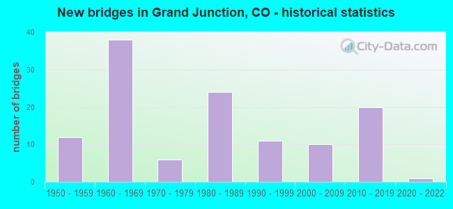
- New bridges - historical statistics
- 121950-1959
- 381960-1969
- 61970-1979
- 241980-1989
- 111990-1999
- 102000-2009
- 202010-2019
- 12020-2022
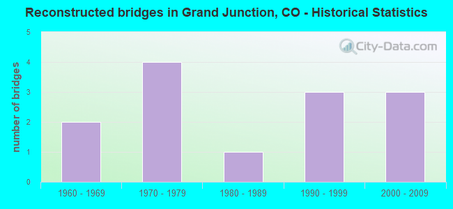
- Reconstructed bridges - Historical Statistics
- 21960-1969
- 41970-1979
- 11980-1989
- 31990-1999
- 32000-2009
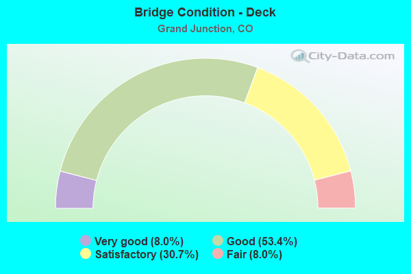
- Bridge Condition - Deck
- 8.0%Very good
- 53.4%Good
- 30.7%Satisfactory
- 8.0%Fair
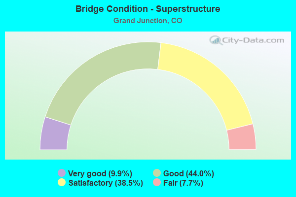
- Bridge Condition - Superstructure
- 9.9%Very good
- 44.0%Good
- 38.5%Satisfactory
- 7.7%Fair
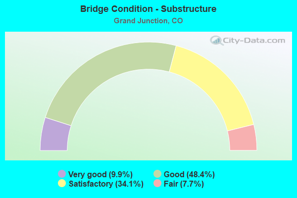
- Bridge Condition - Substructure
- 9.9%Very good
- 48.4%Good
- 34.1%Satisfactory
- 7.7%Fair
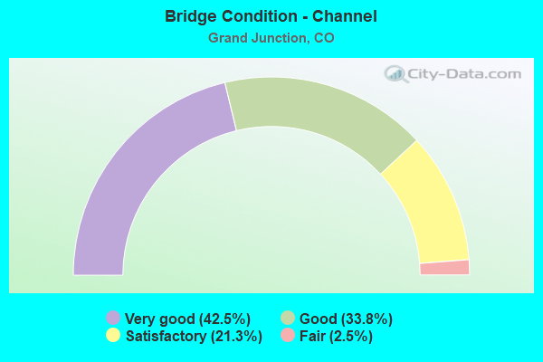
- Bridge Condition - Channel
- 42.5%Very good
- 33.8%Good
- 21.3%Satisfactory
- 2.5%Fair
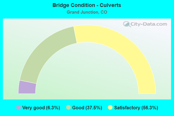
- Bridge Condition - Culverts
- 6.3%Very good
- 37.5%Good
- 56.3%Satisfactory
Find on map >> Show street view
Structure Number: GRJ-22-G.6A, Location: .1 MI N OF HWY 6 (Lat: 39.115778, Lng: -108.645278), Route carried "on" structure: City street , Year Built: 1984, Status: Open, Structure Length: 0.72m (2.36ft), Average Daily Traffic: 3,019 (year 2018), Truck Traffic: 5%, Average Future Daily Traffic: 4,558 (year 2038), Features Intersected: PERSIGO WASH, Facility Carried by Structure: COUNTY ROAD 22
Minimum Vertical Clearance: 30+ m (98+ ft), Kilometerpoint: 0.360, Lanes on structure: 2, Owner: City or Municipal Highway Agency, Approaching Roadway Width: 7.3m (24.0ft), Skew: 4 degrees, Material/Design: Steel, Design/Construction: Stringer/Multi-beam, Number Of Spans In Main Unit: 1, Length of Maximum Span: 6.8m (22.3ft), Curb-To-Curb Width: 9.3m (30.5ft), Out-to-Out Width: 9.9m (32.5ft)
Condition: Deck: Good, Superstructure: Fair, Substructure: Satisfactory, Channel: Satisfactory, Operating Rating: 39.0 metric tons, Method Used To Determine Operating Rating: Load Factor (LF), Inventory Rating: 23.3 metric tons, Method Used To Determine Inventory Rating: Load Factor (LF), Structural Evaluation: Somewhat better than minimum adequacy, Deck Geometry: Meets minimum limits, Waterway Adequacy: Equal to present desirable criteria, Approach Roadway Alignment: Somewhat better than minimum adequacy, Designated Inspection Frequency: Every 24 months, Inspection Date: March 2020, Deck Structure Type: Corrugated Steel, Wearing Surface/Protective System: Wearing Surface: Bituminous
Find on map >> Show street view
Structure Number: GRJ-22-G.7, Location: JUST N OF US 60 (Lat: 39.114083, Lng: -108.647861), Route carried "on" structure: City street , Year Built: 2012, Status: Open, Structure Length: 1.83m (6.00ft), Average Daily Traffic: 8,397 (year 2018), Average Future Daily Traffic: 12,680 (year 2038), Features Intersected: PERSIGO WASH, Facility Carried by Structure: COUNTY ROAD 22
Minimum Vertical Clearance: 30+ m (98+ ft), Kilometerpoint: 0.051, Lanes on structure: 4, Owner: City or Municipal Highway Agency, Approaching Roadway Width: 17.1m (56.1ft), Skew: 6 degrees, Material/Design: Concrete, Design/Construction: Culvert, Number Of Spans In Main Unit: 2, Length of Maximum Span: 8.5m (27.9ft), Out-to-Out Width: 33.8m (110.9ft)
Condition: Channel: Satisfactory, Culverts: Good, Operating Rating: 36.3 metric tons, Method Used To Determine Operating Rating: Field evaluation and documented engineering judgment, Inventory Rating: 32.7 metric tons, Method Used To Determine Inventory Rating: Field evaluation and documented engineering judgment, Structural Evaluation: Better than present minimum criteria, Waterway Adequacy: Equal to present desirable criteria, Approach Roadway Alignment: Equal to present minimum criteria, Designated Inspection Frequency: Every 24 months, Inspection Date: March 2020
Find on map >> Show street view
Structure Number: GRJ-22.22-D.73, Location: 0.5 MI S OF HWY 340 (Lat: 39.073556, Lng: -108.640667), Route carried "on" structure: City street , Year Built: 2000, Status: Open, Structure Length: 0.94m (3.08ft), Average Daily Traffic: 5,469 (year 2018), Average Future Daily Traffic: 8,258 (year 2038), Design Load: HS 20+Mod, Features Intersected: REDLANDS 2ND LIFT CANAL, Facility Carried by Structure: REDLANDS PARKWAY
Minimum Vertical Clearance: 30+ m (98+ ft), Kilometerpoint: 2.491, Lanes on structure: 2, Owner: City or Municipal Highway Agency, Approaching Roadway Width: 11.0m (36.1ft), Skew: 6 degrees, Material/Design: Aluminum, Iron, Design/Construction: Culvert, Number Of Spans In Main Unit: 1, Length of Maximum Span: 9.4m (30.8ft), Curb or Sidewalk Widths: Left: 0.0m, Right: 3.2m (10.5ft), Out-to-Out Width: 25.9m (85.0ft)
Condition: Channel: Satisfactory, Culverts: Satisfactory, Operating Rating: 99.8 metric tons, Method Used To Determine Operating Rating: Load Factor (LF), Inventory Rating: 59.8 metric tons, Method Used To Determine Inventory Rating: Load Factor (LF), Structural Evaluation: Equal to present minimum criteria, Waterway Adequacy: Equal to present desirable criteria, Approach Roadway Alignment: Better than present minimum criteria, Designated Inspection Frequency: Every 24 months, Inspection Date: March 2020
Find on map >> Show street view
Structure Number: GRJ-23.08-E.76, Location: REDLANDS PKWY OVER COLO R (Lat: 39.087722, Lng: -108.625861), Route carried "on" structure: City street , Year Built: 1982, Status: Open, Structure Length: 21.41m (70.24ft), Average Daily Traffic: 16,757 (year 2018), Truck Traffic: 7%, Average Future Daily Traffic: 25,302 (year 2038), Design Load: HS 20, Features Intersected: COLORADO RIVER, Facility Carried by Structure: REDLANDS PARKWAY
Minimum Vertical Clearance: 30+ m (98+ ft), Kilometerpoint: 2.098, Lanes on structure: 2, Owner: City or Municipal Highway Agency, Approaching Roadway Width: 10.4m (34.1ft), Material/Design: Steel continuous, Design/Construction: Box Beam or Girders - Single/Spread, Number Of Spans In Main Unit: 6, Length of Maximum Span: 39.3m (128.9ft), Curb or Sidewalk Widths: Left: 0.0m, Right: 2.4m (7.9ft), Curb-To-Curb Width: 12.0m (39.4ft), Out-to-Out Width: 15.5m (50.9ft)
Condition: Deck: Satisfactory, Superstructure: Fair, Substructure: Fair, Channel: Good, Operating Rating: 58.2 metric tons, Method Used To Determine Operating Rating: Load Factor (LF), Inventory Rating: 34.8 metric tons, Method Used To Determine Inventory Rating: Load Factor (LF), Structural Evaluation: Somewhat better than minimum adequacy, Deck Geometry: Somewhat better than minimum adequacy, Waterway Adequacy: Equal to present desirable criteria, Approach Roadway Alignment: Better than present minimum criteria, Designated Inspection Frequency: Every 24 months, Underwater Inspection Frequency: Every 60 months, Inspection Date: March 2020, Underwater Inspection Date: September 2020, Deck Structure Type: Concrete Cast-file-Place, Wearing Surface/Protective System: Wearing Surface: Bituminous
Find on map >> Show street view
Structure Number: GRJ-23.95-E.96, Location: JCT I-70B and 24 RD (Lat: 39.090861, Lng: -108.609694), Route carried "on" structure: City street , Year Built: 1984, Status: Posted for load, Structure Length: 14.57m (47.80ft), Average Daily Traffic: 19,920 (year 2018), Truck Traffic: 7%, Average Future Daily Traffic: 30,079 (year 2038), Design Load: HS 20, Features Intersected: I-70B & UPPR RR, Facility Carried by Structure: REDLANDS PKY/24 RD
Minimum Vertical Clearance: 30+ m (98+ ft), Kilometerpoint: 3.376, Lanes on structure: 5, Lanes under structure: 7, Owner: City or Municipal Highway Agency, Approaching Roadway Width: 20.1m (65.9ft), Material/Design: Steel, Design/Construction: Stringer/Multi-beam, Number Of Spans In Main Unit: 2, Number Of Approach Spans: 5, Length of Maximum Span: 30.4m (99.7ft), Curb-To-Curb Width: 20.1m (65.9ft), Out-to-Out Width: 21.3m (69.9ft)
Condition: Deck: Satisfactory, Superstructure: Good, Substructure: Satisfactory, Operating Rating: 34.8 metric tons, Method Used To Determine Operating Rating: Load Factor (LF), Inventory Rating: 20.9 metric tons, Method Used To Determine Inventory Rating: Load Factor (LF), Structural Evaluation: Somewhat better than minimum adequacy, Deck Geometry: Somewhat better than minimum adequacy, Underclear: Meets minimum limits, Approach Roadway Alignment: Better than present minimum criteria, Bridge Posting: Required (Relationship of Operating Rating to Maximum Legal Load: 0.1 - 9.9% below), Designated Inspection Frequency: Every 24 months, Inspection Date: Febuary 2022, Deck Structure Type: Concrete Cast-file-Place, Wearing Surface/Protective System: Wearing Surface: Bituminous
Find on map >> Show street view
Structure Number: GRJ-24.07-E.85, Location: NE OF REDLANDS PKWY INTR (Lat: 39.092611, Lng: -108.607917), Route carried "on" structure: Ramp City street , Year Built: 1983, Status: Open, Structure Length: 0.78m (2.56ft), Average Daily Traffic: 739 (year 2018), Truck Traffic: 2%, Average Future Daily Traffic: 1,116 (year 2038), Features Intersected: LEACH CREEK, Facility Carried by Structure: RAMP TO WB I-70B
Minimum Vertical Clearance: 30+ m (98+ ft), Kilometerpoint: 0.063, Lanes on structure: 1, Owner: City or Municipal Highway Agency, Approaching Roadway Width: 7.9m (25.9ft), Skew: 2 degrees, Material/Design: Steel, Design/Construction: Arch - Deck, Number Of Spans In Main Unit: 2, Length of Maximum Span: 3.6m (11.8ft), Curb-To-Curb Width: 7.9m (25.9ft), Out-to-Out Width: 32.2m (105.6ft)
Condition: Superstructure: Satisfactory, Substructure: Satisfactory, Channel: Satisfactory, Structural Evaluation: Equal to present minimum criteria, Deck Geometry: Equal to present desirable criteria, Waterway Adequacy: Equal to present desirable criteria, Approach Roadway Alignment: Equal to present minimum criteria, Designated Inspection Frequency: Every 24 months, Inspection Date: Febuary 2022
Find on map >> Show street view
Structure Number: GRJ-24.07-E.9, Location: NE OF REDLANDS PKWY INTR (Lat: 39.093028, Lng: -108.607917), Route carried "on" structure: Ramp City street , Year Built: 1983, Status: Open, Structure Length: 1.03m (3.38ft), Average Daily Traffic: 1,852 (year 2018), Truck Traffic: 5%, Average Future Daily Traffic: 2,796 (year 2038), Features Intersected: LEACH CREEK, Facility Carried by Structure: NB RAMP TO 24 RD.
Minimum Vertical Clearance: 30+ m (98+ ft), Kilometerpoint: 0.518, Lanes on structure: 1, Owner: City or Municipal Highway Agency, Approaching Roadway Width: 7.3m (24.0ft), Skew: 4 degrees, Material/Design: Steel, Design/Construction: Arch - Deck, Number Of Spans In Main Unit: 2, Length of Maximum Span: 4.7m (15.4ft), Curb-To-Curb Width: 7.3m (24.0ft), Out-to-Out Width: 28.3m (92.8ft)
Condition: Superstructure: Satisfactory, Substructure: Good, Channel: Satisfactory, Structural Evaluation: Equal to present minimum criteria, Deck Geometry: Better than present minimum criteria, Waterway Adequacy: Equal to present desirable criteria, Approach Roadway Alignment: Equal to present desirable criteria, Designated Inspection Frequency: Every 24 months, Inspection Date: Febuary 2022
Find on map >> Show street view
Structure Number: GRJ-24.9-C.7A, Location: .7 MI N OF COUNTY ROAD C (Lat: 39.059056, Lng: -108.590194), Route carried "on" structure: City street , Year Built: 1996, Status: Open, Structure Length: 1.52m (4.99ft), Average Daily Traffic: 4,938 (year 2018), Truck Traffic: 5%, Average Future Daily Traffic: 7,457 (year 2038), Design Load: HS 20, Features Intersected: NO THOROUGHFARE CANYON, Facility Carried by Structure: MONUMENT ROAD
Minimum Vertical Clearance: 30+ m (98+ ft), Kilometerpoint: 3.621, Lanes on structure: 2, Owner: City or Municipal Highway Agency, Approaching Roadway Width: 9.8m (32.2ft), Skew: 4 degrees, Material/Design: Prestressed concrete, Design/Construction: Slab, Number Of Spans In Main Unit: 1, Length of Maximum Span: 13.0m (42.7ft), Curb or Sidewalk Widths: Left: 2.4m (7.9ft), Right: 0.0m, Curb-To-Curb Width: 10.5m (34.4ft), Out-to-Out Width: 13.9m (45.6ft)
Condition: Deck: Good, Superstructure: Very good, Substructure: Good, Channel: Good, Operating Rating: 67.0 metric tons, Method Used To Determine Operating Rating: Load Factor (LF), Inventory Rating: 41.8 metric tons, Method Used To Determine Inventory Rating: Load Factor (LF), Structural Evaluation: Better than present minimum criteria, Deck Geometry: Somewhat better than minimum adequacy, Waterway Adequacy: Equal to present desirable criteria, Approach Roadway Alignment: Better than present minimum criteria, Designated Inspection Frequency: Every 24 months, Inspection Date: March 2020, Deck Structure Type: Other, Wearing Surface/Protective System: Wearing Surface: Bituminous, Membrane: Built-up
Find on map >> Show street view
Structure Number: GRJ-25-E.2, Location: .1 MILES S OF I-70B IN GJ (Lat: 39.080389, Lng: -108.589056), Route carried "on" structure: City street , Year Built: 2009, Status: Open, Structure Length: 18.29m (60.01ft), Average Daily Traffic: 13,413 (year 2018), Truck Traffic: 7%, Average Future Daily Traffic: 20,254 (year 2038), Design Load: HL 93, Features Intersected: RVRSD PW, IND AV, UPRR, Facility Carried by Structure: 25 Road
Minimum Vertical Clearance: 30+ m (98+ ft), Kilometerpoint: 0.229, Lanes on structure: 4, Lanes under structure: 4, Owner: City or Municipal Highway Agency, Approaching Roadway Width: 19.2m (63.0ft), Skew: 29 degrees, Material/Design: Prestressed concrete, Design/Construction: Stringer/Multi-beam, Number Of Spans In Main Unit: 5, Length of Maximum Span: 40.7m (133.5ft), Curb or Sidewalk Widths: Left: 3.2m (10.5ft), Right: 0.0m, Curb-To-Curb Width: 19.1m (62.7ft), Out-to-Out Width: 23.3m (76.4ft)
Condition: Deck: Good, Superstructure: Good, Substructure: Good, Operating Rating: 46.0 metric tons, Method Used To Determine Operating Rating: Load and Resistance Factor Rating (LRFR) rating reported by rating factor(RF) method using HL-93 loadings, Inventory Rating: 35.3 metric tons, Method Used To Determine Inventory Rating: Load and Resistance Factor Rating (LRFR) rating reported by rating factor(RF) method using HL-93 loadings, Structural Evaluation: Better than present minimum criteria, Deck Geometry: Equal to present minimum criteria, Underclear: High priority of corrective action, Approach Roadway Alignment: Better than present minimum criteria, Designated Inspection Frequency: Every 24 months, Inspection Date: March 2020, Deck Structure Type: Concrete Cast-file-Place, Wearing Surface/Protective System: Wearing Surface: Bituminous, Membrane: Built-up, Deck Protection: Epoxy Coated Reinforcing
Find on map >> Show street view
Structure Number: GRJ-25.2-C.99A, Location: JUST S OF BROADWAY (Lat: 39.062333, Lng: -108.588056), Route carried "on" structure: City street , Year Built: 1994, Status: Open, Structure Length: 1.55m (5.09ft), Average Daily Traffic: 5,933 (year 2018), Truck Traffic: 5%, Average Future Daily Traffic: 8,960 (year 2038), Design Load: HS 20, Features Intersected: NO THROUGHFARE CANYON, Facility Carried by Structure: MONUMENT ROAD
Minimum Vertical Clearance: 30+ m (98+ ft), Kilometerpoint: 4.050, Lanes on structure: 3, Owner: City or Municipal Highway Agency, Approaching Roadway Width: 14.6m (47.9ft), Skew: 4 degrees, Material/Design: Prestressed concrete, Design/Construction: Tee Beam, Number Of Spans In Main Unit: 1, Length of Maximum Span: 14.0m (45.9ft), Curb-To-Curb Width: 15.3m (50.2ft), Out-to-Out Width: 16.2m (53.1ft)
Condition: Deck: Good, Superstructure: Good, Substructure: Good, Channel: Very good, Operating Rating: 58.6 metric tons, Method Used To Determine Operating Rating: Load Factor (LF), Inventory Rating: 35.1 metric tons, Method Used To Determine Inventory Rating: Load Factor (LF), Structural Evaluation: Better than present minimum criteria, Deck Geometry: Equal to present minimum criteria, Waterway Adequacy: Equal to present desirable criteria, Approach Roadway Alignment: Better than present minimum criteria, Designated Inspection Frequency: Every 48 months, Inspection Date: March 2020, Deck Structure Type: Other, Wearing Surface/Protective System: Wearing Surface: Bituminous, Membrane: Built-up, Deck Protection: Epoxy Coated Reinforcing
Find on map >> Show street view
Structure Number: GRJ-25.2-D.2A, Location: MONUMENT ROAD AND D ROAD (Lat: 39.063694, Lng: -108.586417), Route carried "on" structure: City street , Year Built: 2009, Status: Open, Structure Length: 1.90m (6.23ft), Average Daily Traffic: 6,278 (year 2018), Truck Traffic: 7%, Average Future Daily Traffic: 9,480 (year 2038), Design Load: HS 25 or greater, Features Intersected: REDLANDS POWER CANAL, Facility Carried by Structure: MONUMENT ROAD
Minimum Vertical Clearance: 30+ m (98+ ft), Kilometerpoint: 4.315, Lanes on structure: 2, Owner: City or Municipal Highway Agency, Approaching Roadway Width: 12.8m (42.0ft), Material/Design: Prestressed concrete, Design/Construction: Slab, Number Of Spans In Main Unit: 1, Length of Maximum Span: 17.5m (57.4ft), Curb or Sidewalk Widths: Left: 1.7m (5.6ft), Right: 0.0m, Curb-To-Curb Width: 14.5m (47.6ft), Out-to-Out Width: 17.1m (56.1ft)
Condition: Deck: Good, Superstructure: Good, Substructure: Good, Channel: Very good, Inventory Rating: 53.4 metric tons, Method Used To Determine Inventory Rating: Load Factor (LF), Structural Evaluation: Better than present minimum criteria, Deck Geometry: Superior to present desirable criteria, Waterway Adequacy: Equal to present desirable criteria, Approach Roadway Alignment: Equal to present minimum criteria, Designated Inspection Frequency: Every 24 months, Inspection Date: March 2020, Deck Structure Type: Concrete Cast-file-Place, Wearing Surface/Protective System: Wearing Surface: Epoxy Overlay, Membrane: Built-up, Deck Protection: Epoxy Coated Reinforcing
Find on map >> Show street view
Structure Number: GRJ-25.3-D.1A, Location: JUST S OF MONUMENT ROAD (Lat: 39.063278, Lng: -108.585861), Route carried "on" structure: City street , Year Built: 2010, Status: Open, Structure Length: 1.70m (5.58ft), Average Daily Traffic: 2,409 (year 2018), Truck Traffic: 5%, Average Future Daily Traffic: 3,638 (year 2038), Features Intersected: NO THOROUGHFARE CANYON, Facility Carried by Structure: COUNTY ROAD D
Minimum Vertical Clearance: 30+ m (98+ ft), Kilometerpoint: 0.045, Lanes on structure: 2, Owner: City or Municipal Highway Agency, Approaching Roadway Width: 7.9m (25.9ft), Skew: 1 degrees, Material/Design: Prestressed concrete, Design/Construction: Slab, Number Of Spans In Main Unit: 1, Length of Maximum Span: 15.4m (50.5ft), Curb or Sidewalk Widths: Left: 1.6m (5.2ft), Right: 1.6m (5.2ft), Curb-To-Curb Width: 10.5m (34.4ft), Out-to-Out Width: 14.8m (48.6ft)
Condition: Deck: Very good, Superstructure: Very good, Substructure: Very good, Channel: Very good, Operating Rating: 77.1 metric tons, Method Used To Determine Operating Rating: Load and Resistance Factor Rating (LRFR) rating reported by rating factor(RF) method using HL-93 loadings, Inventory Rating: 53.1 metric tons, Method Used To Determine Inventory Rating: Load and Resistance Factor Rating (LRFR) rating reported by rating factor(RF) method using HL-93 loadings, Structural Evaluation: Equal to present desirable criteria, Deck Geometry: Somewhat better than minimum adequacy, Waterway Adequacy: Equal to present desirable criteria, Approach Roadway Alignment: Equal to present minimum criteria, Designated Inspection Frequency: Every 24 months, Inspection Date: March 2020, Deck Structure Type: Concrete Cast-file-Place, Wearing Surface/Protective System: Wearing Surface: Epoxy Overlay
Find on map >> Show street view
Structure Number: GRJ-25.5-F.6A, Location: .6 MI N OF PATTERSON ROAD (Lat: 39.100778, Lng: -108.580222), Route carried "on" structure: City street , Year Built: 1999, Status: Open, Structure Length: 0.79m (2.59ft), Average Daily Traffic: 2,468 (year 2018), Truck Traffic: 5%, Average Future Daily Traffic: 3,727 (year 2038), Features Intersected: GRAND VALLEY CANAL, Facility Carried by Structure: 25.5 ROAD
Minimum Vertical Clearance: 30+ m (98+ ft), Kilometerpoint: 2.181, Lanes on structure: 3, Owner: City or Municipal Highway Agency, Approaching Roadway Width: 14.3m (46.9ft), Skew: 1 degrees, Material/Design: Prestressed concrete, Design/Construction: Slab, Number Of Spans In Main Unit: 1, Length of Maximum Span: 6.2m (20.3ft), Curb or Sidewalk Widths: Left: 2.0m (6.6ft), Right: 2.0m (6.6ft), Curb-To-Curb Width: 14.3m (46.9ft), Out-to-Out Width: 19.1m (62.7ft)
Condition: Deck: Good, Superstructure: Good, Substructure: Good, Channel: Very good, Operating Rating: 63.4 metric tons, Method Used To Determine Operating Rating: Load Factor (LF), Inventory Rating: 37.9 metric tons, Method Used To Determine Inventory Rating: Load Factor (LF), Structural Evaluation: Better than present minimum criteria, Deck Geometry: Somewhat better than minimum adequacy, Waterway Adequacy: Equal to present desirable criteria, Approach Roadway Alignment: Equal to present desirable criteria, Designated Inspection Frequency: Every 24 months, Inspection Date: Febuary 2022, Deck Structure Type: Other, Wearing Surface/Protective System: Wearing Surface: Bituminous
Find on map >> Show street view
Structure Number: GRJ-26-G.1, Location: .1 MI N OF RD G (Lat: 39.108083, Lng: -108.570917), Route carried "on" structure: City street , Year Built: 1960, Year Reconstructed: 1990, Status: Open, Structure Length: 1.04m (3.41ft), Average Daily Traffic: 3,536 (year 2018), Truck Traffic: 5%, Average Future Daily Traffic: 5,339 (year 2038), Features Intersected: GRAND VALLEY CANAL, Facility Carried by Structure: 26 Road
Minimum Vertical Clearance: 30+ m (98+ ft), Kilometerpoint: 4.251, Lanes on structure: 2, Owner: City or Municipal Highway Agency, Approaching Roadway Width: 8.2m (26.9ft), Skew: 3 degrees, Material/Design: Steel, Design/Construction: Stringer/Multi-beam, Number Of Spans In Main Unit: 1, Length of Maximum Span: 9.4m (30.8ft), Curb-To-Curb Width: 8.8m (28.9ft), Out-to-Out Width: 9.2m (30.2ft)
Condition: Deck: Fair, Superstructure: Satisfactory, Substructure: Good, Channel: Very good, Operating Rating: 42.9 metric tons, Method Used To Determine Operating Rating: Load Factor (LF), Inventory Rating: 25.7 metric tons, Method Used To Determine Inventory Rating: Load Factor (LF), Structural Evaluation: Equal to present minimum criteria, Deck Geometry: Meets minimum limits, Waterway Adequacy: Equal to present desirable criteria, Approach Roadway Alignment: Equal to present desirable criteria, Designated Inspection Frequency: Every 24 months, Inspection Date: Febuary 2022, Deck Structure Type: Corrugated Steel, Wearing Surface/Protective System: Wearing Surface: Bituminous
Find on map >> Show street view
Structure Number: GRJ-26.5-F.6A, Location: JUST N OF RD F.50 (Lat: 39.098389, Lng: -108.561611), Route carried "on" structure: City street , Year Built: 2010, Status: Open, Structure Length: 0.82m (2.69ft), Average Daily Traffic: 3,406 (year 2018), Truck Traffic: 4%, Average Future Daily Traffic: 5,142 (year 2038), Design Load: HS 20, Features Intersected: GRAND VALLEY CANAL, Facility Carried by Structure: 26.5 Road
Minimum Vertical Clearance: 30+ m (98+ ft), Kilometerpoint: 0.223, Lanes on structure: 2, Owner: City or Municipal Highway Agency, Approaching Roadway Width: 10.4m (34.1ft), Skew: 1 degrees, Material/Design: Concrete, Design/Construction: Frame, Number Of Spans In Main Unit: 1, Length of Maximum Span: 7.7m (25.3ft), Curb or Sidewalk Widths: Left: 1.7m (5.6ft), Right: 1.7m (5.6ft), Curb-To-Curb Width: 9.7m (31.8ft), Out-to-Out Width: 13.9m (45.6ft)
Condition: Deck: Good, Superstructure: Good, Substructure: Good, Channel: Very good, Operating Rating: 42.2 metric tons, Method Used To Determine Operating Rating: Load Factor (LF), Inventory Rating: 25.3 metric tons, Method Used To Determine Inventory Rating: Load Factor (LF), Structural Evaluation: Equal to present minimum criteria, Deck Geometry: Meets minimum limits, Waterway Adequacy: Equal to present desirable criteria, Approach Roadway Alignment: Equal to present desirable criteria, Designated Inspection Frequency: Every 24 months, Inspection Date: Febuary 2022, Deck Structure Type: Other, Wearing Surface/Protective System: Wearing Surface: Epoxy Overlay, Membrane: Epoxy, Deck Protection: Epoxy Coated Reinforcing
Find on map >> Show street view
Structure Number: GRJ-26.5-H.4A, Location: .4 MI N OF RD H (Lat: 39.125889, Lng: -108.561639), Route carried "on" structure: City street , Year Built: 1988, Status: Open, Structure Length: 0.95m (3.12ft), Average Daily Traffic: 1,627 (year 2018), Truck Traffic: 5%, Average Future Daily Traffic: 2,457 (year 2038), Features Intersected: LEACH CREEK, Facility Carried by Structure: 26.5 Road
Minimum Vertical Clearance: 30+ m (98+ ft), Kilometerpoint: 3.297, Lanes on structure: 2, Owner: City or Municipal Highway Agency, Approaching Roadway Width: 6.7m (22.0ft), Skew: 3 degrees, Material/Design: Steel, Design/Construction: Stringer/Multi-beam, Number Of Spans In Main Unit: 1, Length of Maximum Span: 8.5m (27.9ft), Curb-To-Curb Width: 9.4m (30.8ft), Out-to-Out Width: 9.8m (32.2ft)
Condition: Deck: Satisfactory, Superstructure: Satisfactory, Substructure: Satisfactory, Channel: Good, Operating Rating: 33.2 metric tons, Method Used To Determine Operating Rating: Load Factor (LF), Inventory Rating: 19.9 metric tons, Method Used To Determine Inventory Rating: Load Factor (LF), Structural Evaluation: Somewhat better than minimum adequacy, Deck Geometry: Somewhat better than minimum adequacy, Waterway Adequacy: Somewhat better than minimum adequacy, Approach Roadway Alignment: Equal to present desirable criteria, Designated Inspection Frequency: Every 24 months, Inspection Date: Febuary 2022, Deck Structure Type: Corrugated Steel, Wearing Surface/Protective System: Wearing Surface: Bituminous
Find on map >> Show street view
Structure Number: GRJ-27-E.8, Location: 1 BLK N OF BOOKCLIFF AVE (Lat: 39.089139, Lng: -108.552361), Route carried "on" structure: City street , Year Built: 1975, Status: Open, Structure Length: 1.33m (4.36ft), Average Daily Traffic: 16,887 (year 2018), Truck Traffic: 7%, Average Future Daily Traffic: 25,499 (year 2038), Features Intersected: GRAND VALLEY CANAL, Facility Carried by Structure: 12TH STREET
Minimum Vertical Clearance: 30+ m (98+ ft), Kilometerpoint: 2.672, Lanes on structure: 5, Owner: City or Municipal Highway Agency, Approaching Roadway Width: 15.8m (51.8ft), Skew: 5 degrees, Material/Design: Concrete, Design/Construction: Culvert, Number Of Spans In Main Unit: 2, Length of Maximum Span: 6.4m (21.0ft), Curb or Sidewalk Widths: Left: 1.4m (4.6ft), Right: 1.4m (4.6ft), Curb-To-Curb Width: 15.8m (51.8ft), Out-to-Out Width: 25.1m (82.3ft)
Condition: Channel: Satisfactory, Culverts: Satisfactory, Inventory Rating: 62.4 metric tons, Method Used To Determine Inventory Rating: Load Factor (LF), Structural Evaluation: Equal to present minimum criteria, Deck Geometry: High priority of replacement, Waterway Adequacy: Equal to present desirable criteria, Approach Roadway Alignment: Equal to present desirable criteria, Designated Inspection Frequency: Every 24 months, Inspection Date: Febuary 2022
Find on map >> Show street view
Structure Number: GRJ-27.3-C.7, Location: At Winters Ave (Lat: 39.058417, Lng: -108.546556), Route carried "on" structure: City street , Year Built: 2010, Status: Open, Structure Length: 1.00m (3.28ft), Average Daily Traffic: 14,703 (year 2018), Average Future Daily Traffic: 22,201 (year 2038), Features Intersected: LOCAL DRAINAGE, Facility Carried by Structure: RIVERSIDE PARKWAY
Minimum Vertical Clearance: 30+ m (98+ ft), Kilometerpoint: 4.435, Lanes on structure: 3, Owner: City or Municipal Highway Agency, Approaching Roadway Width: 14.5m (47.6ft), Skew: 4 degrees, Material/Design: Concrete, Design/Construction: Culvert, Number Of Spans In Main Unit: 3, Length of Maximum Span: 2.9m (9.5ft), Curb or Sidewalk Widths: Left: 0.0m, Right: 2.1m (6.9ft), Out-to-Out Width: 42.8m (140.4ft)
Condition: Channel: Very good, Culverts: Good, Operating Rating: 96.9 metric tons, Method Used To Determine Operating Rating: Load and Resistance Factor Rating (LRFR) rating reported by rating factor(RF) method using HL-93 loadings, Inventory Rating: 96.9 metric tons, Method Used To Determine Inventory Rating: Load and Resistance Factor Rating (LRFR) rating reported by rating factor(RF) method using HL-93 loadings, Structural Evaluation: Better than present minimum criteria, Waterway Adequacy: Equal to present desirable criteria, Approach Roadway Alignment: Equal to present desirable criteria, Designated Inspection Frequency: Every 24 months, Inspection Date: Febuary 2022
Find on map >> Show street view
Structure Number: GRJ-27.3-E.7, Location: .1 MI S OF WELLINGTON AVE (Lat: 39.088417, Lng: -108.547750), Route carried "on" structure: City street , Year Built: 1984, Status: Open, Structure Length: 1.54m (5.05ft), Average Daily Traffic: 4,909 (year 2018), Truck Traffic: 5%, Average Future Daily Traffic: 7,412 (year 2038), Features Intersected: GRAND VALLEY CANAL, Facility Carried by Structure: 15TH STREET
Minimum Vertical Clearance: 30+ m (98+ ft), Kilometerpoint: 1.196, Lanes on structure: 2, Owner: City or Municipal Highway Agency, Approaching Roadway Width: 11.1m (36.4ft), Skew: 1 degrees, Material/Design: Steel, Design/Construction: Stringer/Multi-beam, Number Of Spans In Main Unit: 1, Length of Maximum Span: 14.3m (46.9ft), Curb or Sidewalk Widths: Left: 1.8m (5.9ft), Right: 1.8m (5.9ft), Curb-To-Curb Width: 9.4m (30.8ft), Out-to-Out Width: 13.8m (45.3ft)
Condition: Deck: Good, Superstructure: Good, Substructure: Good, Channel: Very good, Operating Rating: 49.5 metric tons, Method Used To Determine Operating Rating: Load Factor (LF), Inventory Rating: 29.7 metric tons, Method Used To Determine Inventory Rating: Load Factor (LF), Structural Evaluation: Better than present minimum criteria, Deck Geometry: Meets minimum limits, Waterway Adequacy: Equal to present desirable criteria, Approach Roadway Alignment: Equal to present desirable criteria, Designated Inspection Frequency: Every 24 months, Inspection Date: Febuary 2022, Deck Structure Type: Concrete Cast-file-Place, Wearing Surface/Protective System: Wearing Surface: Bituminous
Find on map >> Show street view
Structure Number: GRJ-28.25-E.75, Location: 0.25 MI N OF ORCHARD AVE (Lat: 39.087750, Lng: -108.529056), Route carried "on" structure: City street , Year Built: 1980, Status: Open, Structure Length: 0.91m (2.99ft), Average Daily Traffic: 8,195 (year 2018), Truck Traffic: 7%, Average Future Daily Traffic: 12,374 (year 2038), Features Intersected: GRAND VALLEY CANAL, Facility Carried by Structure: 28.25 ROAD
Minimum Vertical Clearance: 30+ m (98+ ft), Kilometerpoint: 1.342, Lanes on structure: 4, Owner: City or Municipal Highway Agency, Approaching Roadway Width: 16.8m (55.1ft), Material/Design: Steel, Design/Construction: Culvert, Number Of Spans In Main Unit: 1, Length of Maximum Span: 9.1m (29.9ft), Curb or Sidewalk Widths: Left: 2.1m (6.9ft), Right: 2.1m (6.9ft), Curb-To-Curb Width: 16.8m (55.1ft), Out-to-Out Width: 21.5m (70.5ft)
Condition: Channel: Very good, Culverts: Satisfactory, Operating Rating: 34.9 metric tons, Method Used To Determine Operating Rating: Allowable Stress (AS), Inventory Rating: 16.5 metric tons, Method Used To Determine Inventory Rating: Allowable Stress (AS), Structural Evaluation: Meets minimum limits, Deck Geometry: Somewhat better than minimum adequacy, Waterway Adequacy: Equal to present desirable criteria, Approach Roadway Alignment: Equal to present desirable criteria, Designated Inspection Frequency: Every 24 months, Inspection Date: Febuary 2020
Find on map >> Show street view
Structure Number: GRJ-29-D.65, Location: OVER I-70 BUSINESS RTE (Lat: 39.072361, Lng: -108.515222), Route carried "on" structure: City street , Year Built: 2010, Status: Open, Structure Length: 23.75m (77.92ft), Average Daily Traffic: 19,908 (year 2018), Truck Traffic: 7%, Average Future Daily Traffic: 30,061 (year 2038), Design Load: HL 93, Features Intersected: RR/I70 Business, Facility Carried by Structure: 29 Road
Minimum Vertical Clearance: 30+ m (98+ ft), Kilometerpoint: 0.275, Lanes on structure: 4, Lanes under structure: 7, Owner: City or Municipal Highway Agency, Approaching Roadway Width: 18.6m (61.0ft), Skew: 31 degrees, Material/Design: Prestressed concrete continuous, Design/Construction: Stringer/Multi-beam, Number Of Spans In Main Unit: 7, Length of Maximum Span: 46.7m (153.2ft), Curb or Sidewalk Widths: Left: 1.7m (5.6ft), Right: 1.7m (5.6ft), Curb-To-Curb Width: 18.6m (61.0ft), Out-to-Out Width: 24.1m (79.1ft)
Condition: Deck: Good, Superstructure: Good, Substructure: Very good, Operating Rating: 44.7 metric tons, Method Used To Determine Operating Rating: Load and Resistance Factor Rating (LRFR) rating reported by rating factor(RF) method using HL-93 loadings, Inventory Rating: 33.0 metric tons, Method Used To Determine Inventory Rating: Load and Resistance Factor Rating (LRFR) rating reported by rating factor(RF) method using HL-93 loadings, Structural Evaluation: Better than present minimum criteria, Deck Geometry: Equal to present minimum criteria, Underclear: High priority of corrective action, Approach Roadway Alignment: Equal to present desirable criteria, Designated Inspection Frequency: Every 24 months, Inspection Date: Febuary 2020, Deck Structure Type: Concrete Precast Panels, Wearing Surface/Protective System: Wearing Surface: Bituminous, Membrane: Built-up, Deck Protection: Epoxy Coated Reinforcing
Find on map >> Show street view
Structure Number: GRJ-29-E.6, Location: .6 MI N OF US 6 (Lat: 39.086111, Lng: -108.515194), Route carried "on" structure: City street , Year Built: 1976, Year Reconstructed: 2004, Status: Open, Structure Length: 0.92m (3.02ft), Average Daily Traffic: 11,619 (year 2018), Truck Traffic: 7%, Average Future Daily Traffic: 17,545 (year 2038), Design Load: HS 20, Features Intersected: GRAND VALLEY CANAL, Facility Carried by Structure: 29 Road
Minimum Vertical Clearance: 30+ m (98+ ft), Kilometerpoint: 1.730, Lanes on structure: 3, Owner: City or Municipal Highway Agency, Approaching Roadway Width: 14.3m (46.9ft), Material/Design: Steel, Design/Construction: Stringer/Multi-beam, Number Of Spans In Main Unit: 1, Length of Maximum Span: 8.5m (27.9ft), Curb or Sidewalk Widths: Left: 1.7m (5.6ft), Right: 1.7m (5.6ft), Curb-To-Curb Width: 14.4m (47.2ft), Out-to-Out Width: 18.5m (60.7ft)
Condition: Deck: Good, Superstructure: Satisfactory, Substructure: Good, Channel: Good, Operating Rating: 61.4 metric tons, Method Used To Determine Operating Rating: Load Factor (LF), Inventory Rating: 36.7 metric tons, Method Used To Determine Inventory Rating: Load Factor (LF), Structural Evaluation: Equal to present minimum criteria, Deck Geometry: Somewhat better than minimum adequacy, Waterway Adequacy: Equal to present desirable criteria, Approach Roadway Alignment: Equal to present desirable criteria, Designated Inspection Frequency: Every 24 months, Inspection Date: Febuary 2020, Deck Structure Type: Concrete Cast-file-Place, Wearing Surface/Protective System: Wearing Surface: Bituminous
Find on map >> Show street view
Structure Number: GRJ-29-F.9A, Location: JUST N OF RD G (Lat: 39.104194, Lng: -108.515222), Route carried "on" structure: City street , Year Built: 1989, Status: Open, Structure Length: 1.90m (6.23ft), Average Daily Traffic: 208 (year 2018), Truck Traffic: 2%, Average Future Daily Traffic: 314 (year 2038), Features Intersected: GOVT HIGHLINE CANAL, Facility Carried by Structure: 29 Road
Minimum Vertical Clearance: 30+ m (98+ ft), Kilometerpoint: 1.824, Lanes on structure: 2, Owner: City or Municipal Highway Agency, Approaching Roadway Width: 7.0m (23.0ft), Skew: 6 degrees, Material/Design: Steel, Design/Construction: Stringer/Multi-beam, Number Of Spans In Main Unit: 1, Length of Maximum Span: 17.3m (56.8ft), Curb-To-Curb Width: 9.7m (31.8ft), Out-to-Out Width: 9.8m (32.2ft)
Condition: Deck: Fair, Superstructure: Satisfactory, Substructure: Good, Channel: Very good, Operating Rating: 42.9 metric tons, Method Used To Determine Operating Rating: Load Factor (LF), Inventory Rating: 25.7 metric tons, Method Used To Determine Inventory Rating: Load Factor (LF), Structural Evaluation: Equal to present minimum criteria, Deck Geometry: Equal to present minimum criteria, Waterway Adequacy: Equal to present desirable criteria, Approach Roadway Alignment: Somewhat better than minimum adequacy, Designated Inspection Frequency: Every 24 months, Inspection Date: Febuary 2022, Deck Structure Type: Corrugated Steel, Wearing Surface/Protective System: Wearing Surface: Bituminous
Find on map >> Show street view
Structure Number: GRJ-D-27.99A, Location: JUST W OF RD 28 (Lat: 39.062972, Lng: -108.533917), Route carried "on" structure: City street , Year Built: 2008, Status: Open, Structure Length: 0.66m (2.17ft), Average Daily Traffic: 11,700 (year 2018), Truck Traffic: 2%, Average Future Daily Traffic: 17,666 (year 2038), Design Load: HL 93, Features Intersected: INDIAN WASH, Facility Carried by Structure: Riverside Parkway
Minimum Vertical Clearance: 30+ m (98+ ft), Kilometerpoint: 5.821, Lanes on structure: 3, Owner: City or Municipal Highway Agency, Approaching Roadway Width: 14.3m (46.9ft), Material/Design: Concrete, Design/Construction: Frame, Number Of Spans In Main Unit: 1, Length of Maximum Span: 6.1m (20.0ft), Curb or Sidewalk Widths: Left: 0.0m, Right: 2.6m (8.5ft), Curb-To-Curb Width: 14.3m (46.9ft), Out-to-Out Width: 23.5m (77.1ft)
Condition: Deck: Good, Superstructure: Good, Substructure: Good, Channel: Good, Operating Rating: 41.7 metric tons, Method Used To Determine Operating Rating: Field evaluation and documented engineering judgment, Inventory Rating: 32.7 metric tons, Method Used To Determine Inventory Rating: Field evaluation and documented engineering judgment, Structural Evaluation: Better than present minimum criteria, Deck Geometry: Somewhat better than minimum adequacy, Waterway Adequacy: Equal to present desirable criteria, Approach Roadway Alignment: Equal to present desirable criteria, Designated Inspection Frequency: Every 24 months, Inspection Date: Febuary 2020, Deck Structure Type: Other, Wearing Surface/Protective System: Wearing Surface: Bituminous
Find on map >> Show street view
Structure Number: GRJ-D.5-27.99A, Location: JUST W OF COUNTY ROAD 28 (Lat: 39.070167, Lng: -108.533889), Route carried "on" structure: City street , Year Built: 1998, Status: Open, Structure Length: 0.87m (2.85ft), Average Daily Traffic: 4,182 (year 2018), Truck Traffic: 5%, Average Future Daily Traffic: 6,315 (year 2038), Design Load: HS 25 or greater, Features Intersected: INDIAN WASH, Facility Carried by Structure: GRAND AVENUE
Minimum Vertical Clearance: 30+ m (98+ ft), Kilometerpoint: 3.219, Lanes on structure: 3, Owner: City or Municipal Highway Agency, Approaching Roadway Width: 12.2m (40.0ft), Material/Design: Concrete, Design/Construction: Frame, Number Of Spans In Main Unit: 1, Length of Maximum Span: 8.2m (26.9ft), Curb or Sidewalk Widths: Left: 1.6m (5.2ft), Right: 1.6m (5.2ft), Curb-To-Curb Width: 14.3m (46.9ft), Out-to-Out Width: 18.4m (60.4ft)
Condition: Deck: Satisfactory, Superstructure: Satisfactory, Substructure: Good, Channel: Good, Operating Rating: 91.0 metric tons, Method Used To Determine Operating Rating: Load Factor (LF), Inventory Rating: 54.4 metric tons, Method Used To Determine Inventory Rating: Load Factor (LF), Structural Evaluation: Equal to present minimum criteria, Deck Geometry: Somewhat better than minimum adequacy, Waterway Adequacy: Equal to present desirable criteria, Approach Roadway Alignment: Equal to present desirable criteria, Designated Inspection Frequency: Every 24 months, Inspection Date: Febuary 2022, Deck Structure Type: Other, Wearing Surface/Protective System: Wearing Surface: Bituminous, Membrane: Built-up, Deck Protection: Epoxy Coated Reinforcing
Find on map >> Show street view
Structure Number: GRJ-D.65-28.9, Location: EB I70B Ramp TO 29 ROAD (Lat: 39.072472, Lng: -108.516111), Route carried "on" structure: Ramp City street , Year Built: 2010, Status: Open, Structure Length: 9.82m (32.22ft), Average Daily Traffic: 3,236 (year 2018), Truck Traffic: 1%, Average Future Daily Traffic: 4,887 (year 2038), Design Load: HL 93, Features Intersected: TERRAIN, Facility Carried by Structure: I-70B RAMP A
Minimum Vertical Clearance: 30+ m (98+ ft), Kilometerpoint: 13.490, Lanes on structure: 2, Owner: City or Municipal Highway Agency, Approaching Roadway Width: 8.6m (28.2ft), Material/Design: Prestressed concrete continuous, Design/Construction: Stringer/Multi-beam, Number Of Spans In Main Unit: 5, Length of Maximum Span: 23.4m (76.8ft), Curb-To-Curb Width: 8.5m (27.9ft), Out-to-Out Width: 9.4m (30.8ft)
Condition: Deck: Good, Superstructure: Good, Substructure: Very good, Operating Rating: 58.3 metric tons, Method Used To Determine Operating Rating: Load and Resistance Factor Rating (LRFR) rating reported by rating factor(RF) method using HL-93 loadings, Inventory Rating: 45.0 metric tons, Method Used To Determine Inventory Rating: Load and Resistance Factor Rating (LRFR) rating reported by rating factor(RF) method using HL-93 loadings, Structural Evaluation: Better than present minimum criteria, Deck Geometry: High priority of corrective action, Approach Roadway Alignment: Equal to present desirable criteria, Designated Inspection Frequency: Every 24 months, Inspection Date: Febuary 2020, Deck Structure Type: Concrete Precast Panels, Wearing Surface/Protective System: Wearing Surface: Bituminous, Membrane: Built-up, Deck Protection: Epoxy Coated Reinforcing
Find on map >> Show street view
Structure Number: GRJ-E.25-27.99, Location: JUST W OF RD 28 (Lat: 39.080917, Lng: -108.533750), Route carried "on" structure: City street , Year Built: 1957, Status: Open, Structure Length: 0.74m (2.43ft), Average Daily Traffic: 2,622 (year 2018), Truck Traffic: 5%, Average Future Daily Traffic: 3,959 (year 2038), Design Load: H 20, Features Intersected: INDIAN WASH, Facility Carried by Structure: ELM AVENUE
Minimum Vertical Clearance: 30+ m (98+ ft), Kilometerpoint: 1.284, Lanes on structure: 2, Owner: City or Municipal Highway Agency, Approaching Roadway Width: 10.4m (34.1ft), Material/Design: Prestressed concrete, Design/Construction: Tee Beam, Number Of Spans In Main Unit: 1, Length of Maximum Span: 6.2m (20.3ft), Curb or Sidewalk Widths: Left: 1.4m (4.6ft), Right: 1.4m (4.6ft), Curb-To-Curb Width: 9.4m (30.8ft), Out-to-Out Width: 12.2m (40.0ft)
Condition: Deck: Satisfactory, Superstructure: Satisfactory, Substructure: Good, Channel: Good, Operating Rating: 36.3 metric tons, Method Used To Determine Operating Rating: Field evaluation and documented engineering judgment, Inventory Rating: 32.7 metric tons, Method Used To Determine Inventory Rating: Field evaluation and documented engineering judgment, Structural Evaluation: Equal to present minimum criteria, Deck Geometry: Meets minimum limits, Waterway Adequacy: Equal to present desirable criteria, Approach Roadway Alignment: Equal to present desirable criteria, Designated Inspection Frequency: Every 24 months, Inspection Date: Febuary 2022, Deck Structure Type: Concrete Cast-file-Place, Wearing Surface/Protective System: Wearing Surface: Monolithic Concrete
Find on map >> Show street view
Structure Number: GRJ-E.5-28.6A, Location: JUST E OF NORMANDY DR (Lat: 39.084833, Lng: -108.522000), Route carried "on" structure: City street , Year Built: 1986, Status: Open, Structure Length: 0.74m (2.43ft), Average Daily Traffic: 7,001 (year 2018), Truck Traffic: 7%, Average Future Daily Traffic: 10,572 (year 2038), Features Intersected: INDIAN WASH, Facility Carried by Structure: ORCHARD AVENUE
Minimum Vertical Clearance: 30+ m (98+ ft), Kilometerpoint: 4.422, Lanes on structure: 3, Owner: City or Municipal Highway Agency, Approaching Roadway Width: 11.5m (37.7ft), Skew: 5 degrees, Material/Design: Concrete, Design/Construction: Culvert, Number Of Spans In Main Unit: 1, Length of Maximum Span: 7.4m (24.3ft), Curb or Sidewalk Widths: Left: 1.7m (5.6ft), Right: 1.7m (5.6ft), Out-to-Out Width: 18.0m (59.1ft)
Condition: Channel: Good, Culverts: Satisfactory, Inventory Rating: 62.5 metric tons, Method Used To Determine Inventory Rating: Load Factor (LF), Structural Evaluation: Equal to present minimum criteria, Waterway Adequacy: Equal to present desirable criteria, Approach Roadway Alignment: Equal to present desirable criteria, Designated Inspection Frequency: Every 24 months, Inspection Date: Febuary 2022
Find on map >> Show street view
Structure Number: GRJ-E.70-24.01, Location: Just E of Redlands Pkwy (Lat: 39.090278, Lng: -108.607889), Route carried "on" structure: City street , Year Built: 2008, Status: Open, Structure Length: 0.67m (2.20ft), Average Daily Traffic: 7,738 (year 2018), Truck Traffic: 5%, Average Future Daily Traffic: 11,685 (year 2038), Design Load: HS 20, Features Intersected: LEACH CREEK, Facility Carried by Structure: RIVERSIDE PARKWAY
Minimum Vertical Clearance: 30+ m (98+ ft), Kilometerpoint: 0.391, Lanes on structure: 3, Owner: City or Municipal Highway Agency, Approaching Roadway Width: 14.0m (45.9ft), Skew: 1 degrees, Material/Design: Concrete, Design/Construction: Culvert, Number Of Spans In Main Unit: 2, Length of Maximum Span: 3.2m (10.5ft), Curb or Sidewalk Widths: Left: 1.7m (5.6ft), Right: 0.0m, Curb-To-Curb Width: 13.7m (44.9ft), Out-to-Out Width: 34.7m (113.8ft)
Condition: Channel: Satisfactory, Culverts: Good, Operating Rating: 44.7 metric tons, Method Used To Determine Operating Rating: Load Factor (LF), Inventory Rating: 26.8 metric tons, Method Used To Determine Inventory Rating: Load Factor (LF), Structural Evaluation: Equal to present minimum criteria, Deck Geometry: Somewhat better than minimum adequacy, Waterway Adequacy: Equal to present desirable criteria, Approach Roadway Alignment: Equal to present desirable criteria, Designated Inspection Frequency: Every 24 months, Inspection Date: March 2020
Find on map >> Show street view
Structure Number: GRJ-E.96-23.95, Location: I-70B AND REDLANDS PKWY (Lat: 39.091722, Lng: -108.609417), Route carried "on" structure: Ramp City street , Year Built: 1983, Status: Open, Structure Length: 13.46m (44.16ft), Average Daily Traffic: 4,845 (year 2018), Truck Traffic: 5%, Average Future Daily Traffic: 7,316 (year 2038), Design Load: HS 20, Features Intersected: TERRAIN, Facility Carried by Structure: REDLAND PKWY RAMP
Minimum Vertical Clearance: 30+ m (98+ ft), Kilometerpoint: 0.195, Lanes on structure: 1, Owner: City or Municipal Highway Agency, Approaching Roadway Width: 7.9m (25.9ft), Material/Design: Steel continuous, Design/Construction: Box Beam or Girders - Single/Spread, Number Of Spans In Main Unit: 3, Number Of Approach Spans: 1, Length of Maximum Span: 47.2m (154.9ft), Curb-To-Curb Width: 7.9m (25.9ft), Out-to-Out Width: 9.1m (29.9ft)
Condition: Deck: Satisfactory, Superstructure: Satisfactory, Substructure: Satisfactory, Operating Rating: 32.7 metric tons, Method Used To Determine Operating Rating: Load Factor (LF), Inventory Rating: 19.5 metric tons, Method Used To Determine Inventory Rating: Load Factor (LF), Structural Evaluation: Somewhat better than minimum adequacy, Deck Geometry: Equal to present desirable criteria, Approach Roadway Alignment: High priority of corrective action, Designated Inspection Frequency: Every 24 months, Critical Feature Inspection Frequency: Every 24 months, Inspection Date: Febuary 2022, Critical Feature Inspection Date: Febuary 2022, Deck Structure Type: Concrete Cast-file-Place, Wearing Surface/Protective System: Wearing Surface: Bituminous
Find on map >> Show street view
Structure Number: GRJ-E.96-24.05, Location: I-70B AND REDLANDS PKWY (Lat: 39.091278, Lng: -108.608583), Route carried "on" structure: Ramp City street , Year Built: 2019, Status: Open, Structure Length: 13.47m (44.19ft), Average Daily Traffic: 4,845 (year 2018), Truck Traffic: 5%, Average Future Daily Traffic: 7,316 (year 2038), Design Load: HS 20, Features Intersected: TERRAIN AND LEACH CREEK, Facility Carried by Structure: REDLAND PKWY RAMP
Minimum Vertical Clearance: 30+ m (98+ ft), Kilometerpoint: 0.026, Lanes on structure: 1, Owner: City or Municipal Highway Agency, Approaching Roadway Width: 7.9m (25.9ft), Material/Design: Steel continuous, Design/Construction: Box Beam or Girders - Single/Spread, Number Of Spans In Main Unit: 3, Number Of Approach Spans: 1, Length of Maximum Span: 47.2m (154.9ft), Curb-To-Curb Width: 7.9m (25.9ft), Out-to-Out Width: 9.1m (29.9ft)
Condition: Deck: Satisfactory, Superstructure: Satisfactory, Substructure: Satisfactory, Channel: Very good, Operating Rating: 32.7 metric tons, Method Used To Determine Operating Rating: Load Factor (LF), Inventory Rating: 19.5 metric tons, Method Used To Determine Inventory Rating: Load Factor (LF), Structural Evaluation: Somewhat better than minimum adequacy, Deck Geometry: Equal to present desirable criteria, Approach Roadway Alignment: Meets minimum limits, Designated Inspection Frequency: Every 24 months, Critical Feature Inspection Frequency: Every 24 months, Inspection Date: Febuary 2022, Critical Feature Inspection Date: Febuary 2022, Deck Structure Type: Concrete Cast-file-Place, Wearing Surface/Protective System: Wearing Surface: Bituminous
Find on map >> Show street view
Structure Number: GRJ-F-26.6A, Location: .7 MI E OF RD 26 (Lat: 39.091861, Lng: -108.558861), Route carried "on" structure: City street , Year Built: 1985, Status: Open, Structure Length: 1.46m (4.79ft), Average Daily Traffic: 24,156 (year 2018), Truck Traffic: 7%, Average Future Daily Traffic: 36,476 (year 2038), Features Intersected: GRAND VALLEY CANAL, Facility Carried by Structure: PATTERSON ROAD
Minimum Vertical Clearance: 30+ m (98+ ft), Kilometerpoint: 4.484, Lanes on structure: 5, Owner: City or Municipal Highway Agency, Approaching Roadway Width: 19.5m (64.0ft), Skew: 2 degrees, Material/Design: Prestressed concrete, Design/Construction: Tee Beam, Number Of Spans In Main Unit: 1, Length of Maximum Span: 13.4m (44.0ft), Curb or Sidewalk Widths: Left: 1.7m (5.6ft), Right: 1.7m (5.6ft), Curb-To-Curb Width: 19.0m (62.3ft), Out-to-Out Width: 23.5m (77.1ft)
Condition: Deck: Good, Superstructure: Satisfactory, Substructure: Good, Channel: Good, Operating Rating: 73.6 metric tons, Method Used To Determine Operating Rating: Load Factor (LF), Inventory Rating: 44.1 metric tons, Method Used To Determine Inventory Rating: Load Factor (LF), Structural Evaluation: Equal to present minimum criteria, Deck Geometry: Meets minimum limits, Waterway Adequacy: Equal to present desirable criteria, Approach Roadway Alignment: Equal to present desirable criteria, Designated Inspection Frequency: Every 24 months, Inspection Date: Febuary 2022, Deck Structure Type: Concrete Cast-file-Place, Wearing Surface/Protective System: Wearing Surface: Bituminous
Find on map >> Show street view
Structure Number: GRJ-F.2-24.01A, Location: JUST E OF RD 24 (Lat: 39.094642, Lng: -108.607919), Route carried "on" structure: City street , Year Built: 1984, Status: Open, Structure Length: 0.73m (2.40ft), Average Daily Traffic: 16,191 (year 2018), Truck Traffic: 7%, Average Future Daily Traffic: 24,448 (year 2038), Features Intersected: LEACH CREEK, Facility Carried by Structure: PATTERSON ROAD
Minimum Vertical Clearance: 30+ m (98+ ft), Kilometerpoint: 0.335, Lanes on structure: 6, Owner: City or Municipal Highway Agency, Approaching Roadway Width: 23.2m (76.1ft), Material/Design: Steel, Design/Construction: Arch - Deck, Number Of Spans In Main Unit: 2, Length of Maximum Span: 3.4m (11.2ft), Curb-To-Curb Width: 23.2m (76.1ft), Out-to-Out Width: 44.2m (145.0ft)
Condition: Superstructure: Fair, Substructure: Fair, Channel: Satisfactory, Structural Evaluation: Somewhat better than minimum adequacy, Deck Geometry: Meets minimum limits, Waterway Adequacy: Equal to present desirable criteria, Approach Roadway Alignment: Equal to present desirable criteria, Designated Inspection Frequency: Every 24 months, Inspection Date: Febuary 2022
Find on map >> Show street view
Structure Number: GRJ-F.4-26.7, Location: .3 MI E OF RD 26.50 (Lat: 39.098222, Lng: -108.557222), Route carried "on" structure: City street , Year Built: 1965, Status: Open, Structure Length: 0.75m (2.46ft), Average Daily Traffic: 6,524 (year 2018), Truck Traffic: 7%, Average Future Daily Traffic: 9,852 (year 2038), Features Intersected: GRAND VALLEY CANAL, Facility Carried by Structure: HORIZON DRIVE
Minimum Vertical Clearance: 30+ m (98+ ft), Kilometerpoint: 0.406, Lanes on structure: 2, Owner: City or Municipal Highway Agency, Approaching Roadway Width: 10.4m (34.1ft), Material/Design: Steel, Design/Construction: Stringer/Multi-beam, Number Of Spans In Main Unit: 1, Length of Maximum Span: 6.6m (21.7ft), Curb or Sidewalk Widths: Left: 0.9m (3.0ft), Right: 0.9m (3.0ft), Curb-To-Curb Width: 9.4m (30.8ft), Out-to-Out Width: 11.2m (36.7ft)
Condition: Deck: Good, Superstructure: Satisfactory, Substructure: Good, Channel: Good, Operating Rating: 50.4 metric tons, Method Used To Determine Operating Rating: Load Factor (LF), Inventory Rating: 30.2 metric tons, Method Used To Determine Inventory Rating: Load Factor (LF), Structural Evaluation: Equal to present minimum criteria, Deck Geometry: High priority of corrective action, Waterway Adequacy: Equal to present desirable criteria, Approach Roadway Alignment: Better than present minimum criteria, Length Of Structure Improvement: 0.75m (2.46ft), Designated Inspection Frequency: Every 24 months, Inspection Date: Febuary 2022, Bridge Improvement Cost: $112,000, Roadway Improvement Cost: $11,000, Total Project Cost: $123,000 ( Estimate for 2020), Deck Structure Type: Concrete Cast-file-Place, Wearing Surface/Protective System: Wearing Surface: Bituminous
Find on map >> Show street view
Structure Number: GRJ-F.5-24.01, Location: JUST EAST OF ROAD 24 (Lat: 39.098889, Lng: -108.607500), Route carried "on" structure: City street , Year Built: 2008, Status: Open, Structure Length: 1.22m (4.00ft), Average Daily Traffic: 2,519 (year 2018), Truck Traffic: 2%, Average Future Daily Traffic: 3,804 (year 2038), Design Load: HS 20, Features Intersected: LEACH CREEK, Facility Carried by Structure: COUNTY ROAD F.5
Minimum Vertical Clearance: 30+ m (98+ ft), Kilometerpoint: 0.455, Lanes on structure: 3, Owner: City or Municipal Highway Agency, Approaching Roadway Width: 7.9m (25.9ft), Material/Design: Concrete, Design/Construction: Culvert, Number Of Spans In Main Unit: 3, Length of Maximum Span: 3.7m (12.1ft), Curb-To-Curb Width: 12.3m (40.4ft), Out-to-Out Width: 30.6m (100.4ft)
Condition: Channel: Satisfactory, Culverts: Good, Operating Rating: 36.3 metric tons, Method Used To Determine Operating Rating: Field evaluation and documented engineering judgment, Inventory Rating: 32.7 metric tons, Method Used To Determine Inventory Rating: Field evaluation and documented engineering judgment, Structural Evaluation: Better than present minimum criteria, Deck Geometry: Meets minimum limits, Waterway Adequacy: Better than present minimum criteria, Approach Roadway Alignment: Somewhat better than minimum adequacy, Designated Inspection Frequency: Every 24 months, Inspection Date: March 2020
Find on map >> Show street view
Structure Number: GRJ-F.5-30.8A, Location: .8 Mi E of RD 30 (Lat: 39.099028, Lng: -108.481222), Route carried "on" structure: City street , Year Built: 2019, Status: Open, Structure Length: 0.82m (2.69ft), Average Daily Traffic: 1,768 (year 2018), Truck Traffic: 5%, Average Future Daily Traffic: 2,670 (year 2038), Design Load: HL 93, Features Intersected: LEWIS WASH, Facility Carried by Structure: F.5 ROAD
Minimum Vertical Clearance: 30+ m (98+ ft), Kilometerpoint: 0.003, Lanes on structure: 2, Owner: City or Municipal Highway Agency, Approaching Roadway Width: 7.0m (23.0ft), Skew: 2 degrees, Material/Design: Concrete, Design/Construction: Culvert, Number Of Spans In Main Unit: 2, Length of Maximum Span: 3.9m (12.8ft), Curb or Sidewalk Widths: Left: 1.8m (5.9ft), Right: 1.8m (5.9ft), Out-to-Out Width: 18.3m (60.0ft)
Condition: Channel: Very good, Culverts: Good, Operating Rating: 96.9 metric tons, Method Used To Determine Operating Rating: Load and Resistance Factor Rating (LRFR) rating reported by rating factor(RF) method using HL-93 loadings, Inventory Rating: 96.9 metric tons, Method Used To Determine Inventory Rating: Load and Resistance Factor Rating (LRFR) rating reported by rating factor(RF) method using HL-93 loadings, Structural Evaluation: Better than present minimum criteria, Waterway Adequacy: Equal to present desirable criteria, Approach Roadway Alignment: Equal to present desirable criteria, Designated Inspection Frequency: Every 24 months, Inspection Date: Febuary 2022
Find on map >> Show street view
Structure Number: GRJ-G-26.1A, Location: .1 MI E OF ROAD 26.00 (Lat: 39.106333, Lng: -108.569861), Route carried "on" structure: City street , Year Built: 1991, Status: Open, Structure Length: 1.30m (4.27ft), Average Daily Traffic: 6,685 (year 2018), Truck Traffic: 7%, Average Future Daily Traffic: 10,095 (year 2038), Design Load: HS 20, Features Intersected: GRAND VALLEY CANAL, Facility Carried by Structure: G Road
Minimum Vertical Clearance: 30+ m (98+ ft), Kilometerpoint: 6.286, Lanes on structure: 2, Owner: City or Municipal Highway Agency, Approaching Roadway Width: 9.1m (29.9ft), Skew: 4 degrees, Material/Design: Prestressed concrete, Design/Construction: Slab, Number Of Spans In Main Unit: 1, Length of Maximum Span: 11.4m (37.4ft), Curb or Sidewalk Widths: Left: 1.2m (3.9ft), Right: 0.0m, Curb-To-Curb Width: 9.1m (29.9ft), Out-to-Out Width: 11.1m (36.4ft)
Condition: Deck: Good, Superstructure: Good, Substructure: Good, Channel: Very good, Operating Rating: 54.9 metric tons, Method Used To Determine Operating Rating: Load Factor (LF), Inventory Rating: 32.8 metric tons, Method Used To Determine Inventory Rating: Load Factor (LF), Structural Evaluation: Better than present minimum criteria, Deck Geometry: High priority of corrective action, Waterway Adequacy: Equal to present desirable criteria, Approach Roadway Alignment: Better than present minimum criteria, Length Of Structure Improvement: 1.30m (4.27ft), Designated Inspection Frequency: Every 24 months, Inspection Date: Febuary 2022, Bridge Improvement Cost: $201,000, Roadway Improvement Cost: $20,000, Total Project Cost: $221,000 ( Estimate for 2020), Deck Structure Type: Other, Wearing Surface/Protective System: Wearing Surface: Bituminous, Membrane: Built-up
Find on map >> Show street view
Structure Number: GRJ-G.6-27.9A, Location: 1 BLK N OF HORIZON COURT (Lat: 39.115000, Lng: -108.534250), Route carried "on" structure: City street , Year Built: 1981, Status: Open, Structure Length: 1.60m (5.25ft), Average Daily Traffic: 7,357 (year 2018), Truck Traffic: 7%, Average Future Daily Traffic: 11,109 (year 2038), Design Load: HS 20, Features Intersected: GOVT. HIGHLINE CANAL, Facility Carried by Structure: HORIZON DRIVE
Minimum Vertical Clearance: 30+ m (98+ ft), Kilometerpoint: 2.165, Lanes on structure: 5, Owner: City or Municipal Highway Agency, Approaching Roadway Width: 20.7m (67.9ft), Skew: 1 degrees, Material/Design: Prestressed concrete, Design/Construction: Tee Beam, Number Of Spans In Main Unit: 1, Length of Maximum Span: 14.8m (48.6ft), Curb or Sidewalk Widths: Left: 1.5m (4.9ft), Right: 1.5m (4.9ft), Curb-To-Curb Width: 20.7m (67.9ft), Out-to-Out Width: 24.3m (79.7ft)
Condition: Deck: Good, Superstructure: Good, Substructure: Satisfactory, Channel: Very good, Operating Rating: 46.5 metric tons, Method Used To Determine Operating Rating: Load Factor (LF), Inventory Rating: 27.9 metric tons, Method Used To Determine Inventory Rating: Load Factor (LF), Structural Evaluation: Equal to present minimum criteria, Deck Geometry: Somewhat better than minimum adequacy, Waterway Adequacy: Equal to present desirable criteria, Approach Roadway Alignment: Equal to present desirable criteria, Designated Inspection Frequency: Every 24 months, Inspection Date: Febuary 2022, Deck Structure Type: Concrete Cast-file-Place, Wearing Surface/Protective System: Wearing Surface: Bituminous
Find on map >> Show street view
Structure Number: GRJ-H-27.01A, Location: JUST E OF RD 27 (Lat: 39.120861, Lng: -108.552000), Route carried "on" structure: City street , Year Built: 1990, Status: Open, Structure Length: 1.66m (5.45ft), Average Daily Traffic: 2,469 (year 2018), Truck Traffic: 5%, Average Future Daily Traffic: 3,729 (year 2038), Features Intersected: GOVT HIGHLINE CANAL, Facility Carried by Structure: H Road
Minimum Vertical Clearance: 30+ m (98+ ft), Kilometerpoint: 1.633, Lanes on structure: 2, Owner: City or Municipal Highway Agency, Approaching Roadway Width: 11.3m (37.1ft), Skew: 3 degrees, Material/Design: Steel, Design/Construction: Stringer/Multi-beam, Number Of Spans In Main Unit: 1, Length of Maximum Span: 16.0m (52.5ft), Curb-To-Curb Width: 10.4m (34.1ft), Out-to-Out Width: 10.7m (35.1ft)
Condition: Deck: Good, Superstructure: Satisfactory, Substructure: Good, Channel: Good, Operating Rating: 31.1 metric tons, Method Used To Determine Operating Rating: Load Factor (LF), Inventory Rating: 18.6 metric tons, Method Used To Determine Inventory Rating: Load Factor (LF), Structural Evaluation: Somewhat better than minimum adequacy, Deck Geometry: Somewhat better than minimum adequacy, Waterway Adequacy: Equal to present desirable criteria, Approach Roadway Alignment: Equal to present desirable criteria, Designated Inspection Frequency: Every 24 months, Inspection Date: Febuary 2022, Deck Structure Type: Corrugated Steel, Wearing Surface/Protective System: Wearing Surface: Bituminous
Find on map >> Show street view
Structure Number: H-02-AX, Location: 3.7 MI E. OF JCT. SH 340 (Lat: 39.122189, Lng: -108.668578), Route carried "on" structure: US 6A, Year Built: 2001, Status: Open, Structure Length: 0.72m (2.36ft), Average Daily Traffic: 11,000 (year 2020), Truck Traffic: 6%, Average Future Daily Traffic: 13,530 (year 2040), Design Load: HS 20+Mod, Features Intersected: HUNTER WASH, Facility Carried by Structure: US 6 ML
Minimum Vertical Clearance: 30+ m (98+ ft), Kilometerpoint: 21.506, Lanes on structure: 2, Owner: State Highway Agency, Approaching Roadway Width: 13.4m (44.0ft), Skew: 4 degrees, Material/Design: Concrete, Design/Construction: Culvert, Number Of Spans In Main Unit: 1, Length of Maximum Span: 7.2m (23.6ft), Out-to-Out Width: 21.9m (71.9ft)
Condition: Channel: Good, Culverts: Satisfactory, Operating Rating: 36.3 metric tons, Method Used To Determine Operating Rating: Field evaluation and documented engineering judgment, Inventory Rating: 32.7 metric tons, Method Used To Determine Inventory Rating: Field evaluation and documented engineering judgment, Structural Evaluation: Equal to present minimum criteria, Waterway Adequacy: Equal to present desirable criteria, Approach Roadway Alignment: Equal to present desirable criteria, Designated Inspection Frequency: Every 24 months, Inspection Date: January 2021
Find on map >> Show street view
Structure Number: H-02-B, Location: GRAND JCT/REDLANDS PRKY (Lat: 39.091044, Lng: -108.607875), Route carried "on" structure: Business State highway 70B, Year Built: 1968, Year Reconstructed: 1983, Status: Open, Structure Length: 2.01m (6.59ft), Average Daily Traffic: 26,000 (year 2020), Truck Traffic: 5%, Average Future Daily Traffic: 29,120 (year 2040), Design Load: HS 20, Features Intersected: LEACH CREEK, Facility Carried by Structure: I 70 BUSINESS RT
Minimum Vertical Clearance: 30+ m (98+ ft), Kilometerpoint: 3.985, Lanes on structure: 5, Base Highway Network: Yes, Owner: State Highway Agency, Approaching Roadway Width: 33.2m (108.9ft), Skew: 4 degrees, Material/Design: Prestressed concrete, Design/Construction: Stringer/Multi-beam, Number Of Spans In Main Unit: 1, Length of Maximum Span: 18.3m (60.0ft), Curb-To-Curb Width: 37.8m (124.0ft), Out-to-Out Width: 40.4m (132.5ft)
Condition: Deck: Good, Superstructure: Good, Substructure: Good, Channel: Very good, Operating Rating: 46.4 metric tons, Method Used To Determine Operating Rating: Load Factor (LF), Inventory Rating: 24.2 metric tons, Method Used To Determine Inventory Rating: Load Factor (LF), Structural Evaluation: Somewhat better than minimum adequacy, Deck Geometry: Superior to present desirable criteria, Waterway Adequacy: Equal to present minimum criteria, Approach Roadway Alignment: Equal to present desirable criteria, Designated Inspection Frequency: Every 24 months, Inspection Date: January 2021, Deck Structure Type: Concrete Cast-file-Place, Wearing Surface/Protective System: Wearing Surface: Bituminous
Find on map >> Show street view
Structure Number: H-02-CA, Location: SO. END OF GR JUNCT. (Lat: 39.055583, Lng: -108.565125), Route carried "on" structure: US 50A, Year Built: 1965, Year Reconstructed: 2008, Status: Open, Structure Length: 21.46m (70.41ft), Average Daily Traffic: 13,500 (year 2020), Truck Traffic: 4%, Average Future Daily Traffic: 14,850 (year 2040), Design Load: HS 20, Features Intersected: COLORADO RIVER, Facility Carried by Structure: US 50 ML EBND
Minimum Vertical Clearance: 30+ m (98+ ft), Kilometerpoint: 1.104, Lanes on structure: 3, Base Highway Network: Yes, Owner: State Highway Agency, Approaching Roadway Width: 11.6m (38.1ft), Skew: 30 degrees, Material/Design: Steel continuous, Design/Construction: Stringer/Multi-beam, Number Of Spans In Main Unit: 8, Length of Maximum Span: 30.5m (100.1ft), Curb or Sidewalk Widths: Left: 0.0m, Right: 1.1m (3.6ft), Curb-To-Curb Width: 11.6m (38.1ft), Out-to-Out Width: 13.6m (44.6ft)
Condition: Deck: Satisfactory, Superstructure: Satisfactory, Substructure: Satisfactory, Channel: Good, Operating Rating: 45.8 metric tons, Method Used To Determine Operating Rating: Load Factor (LF), Inventory Rating: 27.4 metric tons, Method Used To Determine Inventory Rating: Load Factor (LF), Structural Evaluation: Equal to present minimum criteria, Deck Geometry: High priority of replacement, Waterway Adequacy: Equal to present desirable criteria, Approach Roadway Alignment: Better than present minimum criteria, Designated Inspection Frequency: Every 24 months, Underwater Inspection Frequency: Every 60 months, Inspection Date: November 2020, Underwater Inspection Date: September 2020, Deck Structure Type: Concrete Cast-file-Place, Wearing Surface/Protective System: Wearing Surface: Bituminous