Bridge Statistics for Greece, New York (NY)
Condition, Traffic, Stress, Structural Evaluation, Project Costs
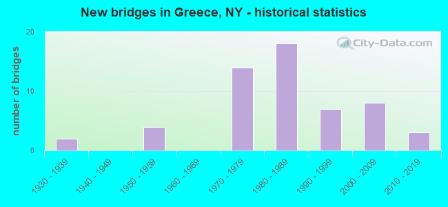
- New bridges - historical statistics
- 21930-1939
- 41950-1959
- 141970-1979
- 181980-1989
- 71990-1999
- 82000-2009
- 32010-2019
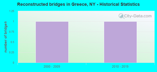
- Reconstructed bridges - Historical Statistics
- 12000-2009
- 12010-2019
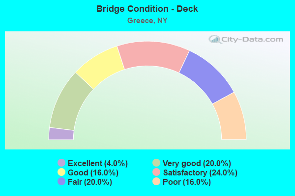
- Bridge Condition - Deck
- 4.0%Excellent
- 20.0%Very good
- 16.0%Good
- 24.0%Satisfactory
- 20.0%Fair
- 16.0%Poor
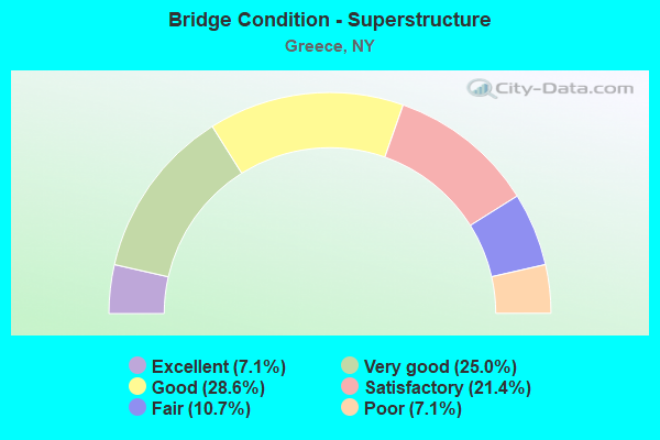
- Bridge Condition - Superstructure
- 7.1%Excellent
- 25.0%Very good
- 28.6%Good
- 21.4%Satisfactory
- 10.7%Fair
- 7.1%Poor
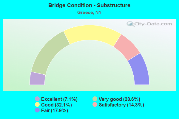
- Bridge Condition - Substructure
- 7.1%Excellent
- 28.6%Very good
- 32.1%Good
- 14.3%Satisfactory
- 17.9%Fair
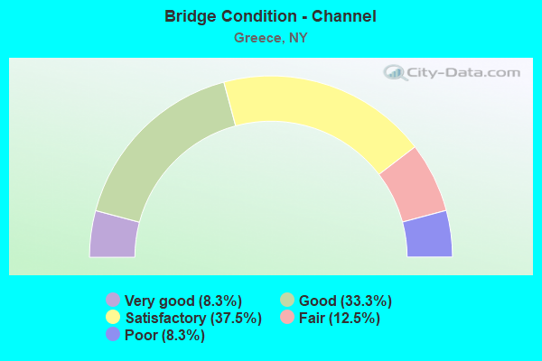
- Bridge Condition - Channel
- 8.3%Very good
- 33.3%Good
- 37.5%Satisfactory
- 12.5%Fair
- 8.3%Poor
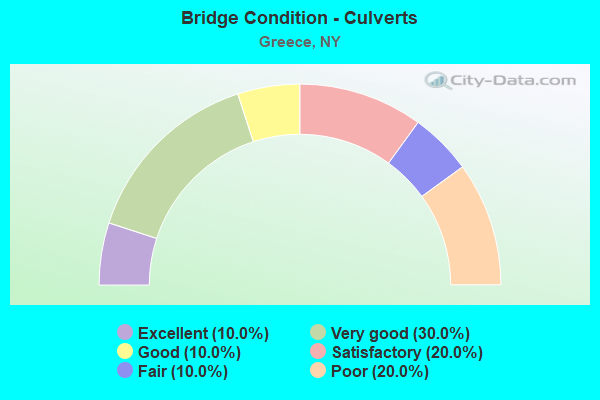
- Bridge Condition - Culverts
- 10.0%Excellent
- 30.0%Very good
- 10.0%Good
- 20.0%Satisfactory
- 10.0%Fair
- 20.0%Poor
Find on map >> Show street view
Structure Number: 103595, Location: 3.1MI E JCT LOSP&RTE 261 (Lat: 43.280869, Lng: -77.695369), Route carried "under" structure: State highway 947A, Year Built: 1955, Structure Length: 0. m, Average Daily Traffic: 10,400 (year 2011), Features Intersected: 947A947A43021177 EB, RTE, Facility Carried by Structure: LONG POND ROAD
Minimum Vertical Clearance: 4.50m (14.76ft), Kilometerpoint: 12.389, Lanes on structure: 2, Lanes under structure: 3, Material/Design: Concrete continuous, Design/Construction: Frame, Length of Maximum Span: 16.1m (52.8ft)
Find on map >> Show street view
Structure Number: 1062471, Location: JCT SH 104 & ROL (Lat: 43.206764, Lng: -77.676167), Route carried "under" structure: State highway 390, Year Built: 2005, Structure Length: 0. m, Average Daily Traffic: 33,500 (year 1971), Features Intersected: 390 390 43011035 NB, RTE, Facility Carried by Structure: RTE 104
Minimum Vertical Clearance: 4.44m (14.57ft), Kilometerpoint: 5.632, Lanes on structure: 3, Lanes under structure: 2, Material/Design: Steel continuous, Design/Construction: Stringer/Multi-beam, Length of Maximum Span: 32.5m (106.6ft)
Find on map >> Show street view
Structure Number: 1062472, Location: JCT NY 390 & RTE 104 (Lat: 43.206583, Lng: -77.675931), Route carried "under" structure: State highway 390, Year Built: 2006, Structure Length: 0. m, Average Daily Traffic: 48,893 (year 2015), Features Intersected: 390 390 43011035, RTE 39, Facility Carried by Structure: RTE 104
Minimum Vertical Clearance: 4.32m (14.17ft), Kilometerpoint: 5.632, Lanes on structure: 3, Lanes under structure: 2, Material/Design: Steel continuous, Design/Construction: Stringer/Multi-beam, Length of Maximum Span: 32.5m (106.6ft)
Find on map >> Show street view
Structure Number: 106248, Location: JCT104WB+ROL RAMP SB (Lat: 43.206731, Lng: -77.675900), Route carried "under" structure: US 104, Year Built: 1971, Structure Length: 0. m, Average Daily Traffic: 35,043 (year 2020), Truck Traffic: 2%, Features Intersected: 104 104 43031168 WB, 390
Minimum Vertical Clearance: 4.55m (14.93ft), Kilometerpoint: 26.967, Lanes on structure: 1, Lanes under structure: 3, Material/Design: Steel continuous, Design/Construction: Stringer/Multi-beam, Length of Maximum Span: 30.4m (99.7ft)
Find on map >> Show street view
Structure Number: 106248, Location: JCT104WB+ROL RAMP SB (Lat: 43.206731, Lng: -77.675900), Route carried "under" structure: State highway 390, Year Built: 1971, Structure Length: 0. m, Average Daily Traffic: 100 (year 2021), Features Intersected: 104 104 43031168 WB, 390, Facility Carried by Structure: RTE 104
Minimum Vertical Clearance: 30+ m (98+ ft), Kilometerpoint: 5.632, Lanes on structure: 1, Lanes under structure: 2, Material/Design: Steel continuous, Design/Construction: Stringer/Multi-beam, Length of Maximum Span: 30.4m (99.7ft)
Find on map >> Show street view
Structure Number: 1062491, Location: 0.6MI S JCT ROL SB+104 (Lat: 43.198247, Lng: -77.680244), Route carried "under" structure: County highway , Year Built: 1971, Structure Length: 0. m, Average Daily Traffic: 4,455 (year 2019), Truck Traffic: 2%, Features Intersected: LATONA RD, Facility Carried by Structure: RTE 390
Minimum Vertical Clearance: 4.62m (15.16ft), Kilometerpoint: 0.644, Lanes on structure: 3, Lanes under structure: 3, Material/Design: Steel, Design/Construction: Stringer/Multi-beam, Length of Maximum Span: 32.0m (105.0ft)
Find on map >> Show street view
Structure Number: 1062492, Location: 0.6MI S JCT ROL NB+104 (Lat: 43.197911, Lng: -77.680236), Route carried "under" structure: County highway , Year Built: 1971, Structure Length: 0. m, Average Daily Traffic: 4,455 (year 2019), Truck Traffic: 2%, Features Intersected: LATONA RD, Facility Carried by Structure: RTE 390
Minimum Vertical Clearance: 4.62m (15.16ft), Kilometerpoint: 0.579, Lanes on structure: 3, Lanes under structure: 3, Material/Design: Steel, Design/Construction: Stringer/Multi-beam, Length of Maximum Span: 32.0m (105.0ft)
Find on map >> Show street view
Structure Number: 1062501, Location: 0.8MI S JCT ROL SB+104 (Lat: 43.195833, Lng: -77.682258), Route carried "under" structure: Other road , Year Built: 1971, Structure Length: 0. m, Features Intersected: WEILAND ROAD, Facility Carried by Structure: RTE 390
Minimum Vertical Clearance: 4.70m (15.42ft), Kilometerpoint: 0.000, Lanes on structure: 3, Lanes under structure: 2, Material/Design: Steel, Design/Construction: Stringer/Multi-beam, Length of Maximum Span: 37.7m (123.7ft)
Find on map >> Show street view
Structure Number: 1062502, Location: 0.8MI S JCT ROL NB+104 (Lat: 43.195853, Lng: -77.681939), Route carried "under" structure: Other road , Year Built: 1971, Structure Length: 0. m, Features Intersected: WEILAND ROAD, Facility Carried by Structure: RTE 390
Minimum Vertical Clearance: 4.42m (14.50ft), Kilometerpoint: 1.593, Lanes on structure: 3, Lanes under structure: 2, Material/Design: Steel, Design/Construction: Stringer/Multi-beam, Length of Maximum Span: 37.7m (123.7ft)
Find on map >> Show street view
Structure Number: 106379, Location: JCT NB ROL + WB 104 (Lat: 43.206933, Lng: -77.674383), Route carried "under" structure: Ramp US , Year Built: 1971, Structure Length: 0. m, Average Daily Traffic: 24,000 (year 2015), Features Intersected: RAMPS GB AND GC, Facility Carried by Structure: RTE 104
Minimum Vertical Clearance: 4.50m (14.76ft), Kilometerpoint: 0.000, Lanes on structure: 1, Lanes under structure: 2, Material/Design: Steel, Design/Construction: Stringer/Multi-beam, Length of Maximum Span: 25.2m (82.7ft)
Find on map >> Show street view
Structure Number: 1071961, Location: 1.2 MI N JCT SH390 &SH104 (Lat: 43.223678, Lng: -77.674900), Route carried "under" structure: Other road , Year Built: 1983, Structure Length: 0. m, Average Daily Traffic: 4,024 (year 2019), Truck Traffic: 4%, Features Intersected: MAIDEN LANE, Facility Carried by Structure: RTE 390
Minimum Vertical Clearance: 4.70m (15.42ft), Kilometerpoint: 1.689, Lanes on structure: 3, Lanes under structure: 2, Material/Design: Steel, Design/Construction: Stringer/Multi-beam, Length of Maximum Span: 34.4m (112.9ft)
Find on map >> Show street view
Structure Number: 1071962, Location: 1.2 MI N JCT SH390 &SH104 (Lat: 43.223681, Lng: -77.674625), Route carried "under" structure: Other road , Year Built: 1983, Structure Length: 0. m, Average Daily Traffic: 4,024 (year 2019), Truck Traffic: 4%, Features Intersected: MAIDEN LANE, Facility Carried by Structure: RTE 390
Minimum Vertical Clearance: 4.52m (14.83ft), Kilometerpoint: 1.786, Lanes on structure: 3, Lanes under structure: 3, Material/Design: Steel, Design/Construction: Stringer/Multi-beam, Length of Maximum Span: 34.4m (112.9ft)
Find on map >> Show street view
Structure Number: 107236, Location: 0.9 MI N JCT RTS 104&390 (Lat: 43.219986, Lng: -77.674933), Route carried "under" structure: State highway , Year Built: 1983, Structure Length: 0. m, Features Intersected: 390 390 43011044 NB, RTE, Facility Carried by Structure: PEDESTRIAN BRIDGE
Minimum Vertical Clearance: 4.57m (14.99ft), Kilometerpoint: 7.080, Lanes under structure: 3, Material/Design: Steel continuous, Design/Construction: Stringer/Multi-beam, Length of Maximum Span: 29.5m (96.8ft)
Find on map >> Show street view
Structure Number: 107236, Location: 0.9 MI N JCT RTS 104&390 (Lat: 43.219986, Lng: -77.674933), Route carried "under" structure: State highway 390, Year Built: 1983, Structure Length: 0. m, Average Daily Traffic: 52,618 (year 2002), Features Intersected: 390 390 43011044 NB, RTE, Facility Carried by Structure: PEDESTRIAN BRIDGE
Minimum Vertical Clearance: 4.55m (14.93ft), Kilometerpoint: 7.080, Lanes under structure: 3, Material/Design: Steel continuous, Design/Construction: Stringer/Multi-beam, Length of Maximum Span: 29.5m (96.8ft)
Find on map >> Show street view
Structure Number: 107237, Location: 2.2MI N JCT RTS 104&390 (Lat: 43.238344, Lng: -77.671239), Route carried "under" structure: State highway 390, Year Built: 1983, Structure Length: 0. m, Average Daily Traffic: 36,300 (year 2010), Features Intersected: 390 390 43011057 NB, RTE, Facility Carried by Structure: ENGLISH ROAD
Minimum Vertical Clearance: 4.60m (15.09ft), Kilometerpoint: 9.123, Lanes on structure: 2, Lanes under structure: 2, Material/Design: Steel continuous, Design/Construction: Stringer/Multi-beam, Length of Maximum Span: 31.0m (101.7ft)
Find on map >> Show street view
Structure Number: 107238, Location: JCT OF RTS 18&390 ROL (Lat: 43.252883, Lng: -77.667925), Route carried "under" structure: State highway 390, Year Built: 1983, Structure Length: 0. m, Average Daily Traffic: 18,653 (year 2002), Features Intersected: 390 390 43011067 NB, RTE, Facility Carried by Structure: RTE 18
Minimum Vertical Clearance: 4.52m (14.83ft), Kilometerpoint: 10.812, Lanes on structure: 6, Lanes under structure: 2, Material/Design: Steel continuous, Design/Construction: Stringer/Multi-beam, Length of Maximum Span: 23.1m (75.8ft)
Find on map >> Show street view
Structure Number: 107242, Location: 1.7MI NO JCT RTS 104&390 (Lat: 43.231072, Lng: -77.672336), Route carried "under" structure: State highway 390, Year Built: 1983, Structure Length: 0. m, Average Daily Traffic: 52,618 (year 2002), Features Intersected: 390 SB, RTE 390, Facility Carried by Structure: VINTAGE LANE
Minimum Vertical Clearance: 4.52m (14.83ft), Kilometerpoint: 8.302, Lanes on structure: 5, Lanes under structure: 2, Material/Design: Steel continuous, Design/Construction: Stringer/Multi-beam, Length of Maximum Span: 29.6m (97.1ft)
Find on map >> Show street view
Structure Number: 226902, Location: .2 mi E Rt 104 & I390 (Lat: 43.206114, Lng: -77.672078), Route carried "under" structure: State highway , Year Built: 1995, Structure Length: 0. m, Features Intersected: 104 43031171, Facility Carried by Structure: Hoover Dr Pedestr
Minimum Vertical Clearance: 4.60m (15.09ft), Kilometerpoint: 1.609, Lanes under structure: 5, Material/Design: Steel, Design/Construction: Truss - Thru, Length of Maximum Span: 50.6m (166.0ft)