Bridge Statistics for Greenburgh, New York (NY)
Condition, Traffic, Stress, Structural Evaluation, Project Costs
- National Bridge Inventory (NBI) Statistics
- 78Number of bridges
- 814ft / 248mTotal length
- $338,105,000Total costs
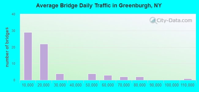
- 1,210,566Total average daily traffic
- 55,428Total average daily truck traffic
- National Bridge Inventory (NBI) Registered Bridges for Greenburgh
- No street view available for this location
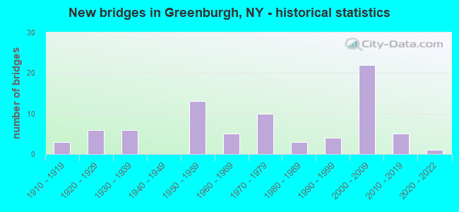
- New bridges - historical statistics
- 31910-1919
- 61920-1929
- 61930-1939
- 131950-1959
- 51960-1969
- 101970-1979
- 31980-1989
- 41990-1999
- 222000-2009
- 52010-2019
- 12020-2022
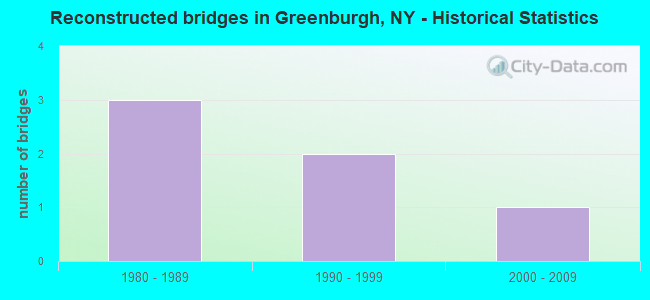
- Reconstructed bridges - Historical Statistics
- 31980-1989
- 21990-1999
- 12000-2009

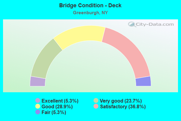
- Bridge Condition - Deck
- 5.3%Excellent
- 23.7%Very good
- 28.9%Good
- 36.8%Satisfactory
- 5.3%Fair
- Bridge Condition - Superstructure
- 9.8%Excellent
- 29.3%Very good
- 12.2%Good
- 22.0%Satisfactory
- 24.4%Fair
- 2.4%Poor
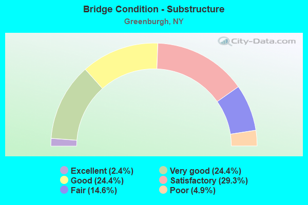
- Bridge Condition - Substructure
- 2.4%Excellent
- 24.4%Very good
- 24.4%Good
- 29.3%Satisfactory
- 14.6%Fair
- 4.9%Poor
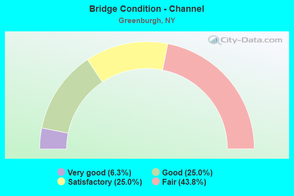
- Bridge Condition - Channel
- 6.3%Very good
- 25.0%Good
- 25.0%Satisfactory
- 43.8%Fair
Find on map >> Show street view
Structure Number: 5513909, Location: SAW MILL R & NYCRR & PRKW (Lat: 41.043336, Lng: -73.835856), Route carried "on" structure: Interstate 87, Year Built: 1953, Status: Open, Structure Length: 23.44m (76.90ft), Average Daily Traffic: 50,309 (year 2018), Truck Traffic: 19%, Average Future Daily Traffic: 85,193 (year 2040), Design Load: HS 20+Mod, Features Intersected: RTE 987, SAW MILL RIVER,
Minimum Vertical Clearance: 30+ m (98+ ft), Kilometerpoint: 16.508, Lanes on structure: 6, Lanes under structure: 6, Base Highway Network: Yes, Toll: On Interstate toll segment, Owner: State Toll Authority, Approaching Roadway Width: 34.4m (112.9ft), Skew: 25 degrees, Material/Design: Steel, Design/Construction: Stringer/Multi-beam, Number Of Spans In Main Unit: 7, Length of Maximum Span: 37.8m (124.0ft), Curb-To-Curb Width: 31.7m (104.0ft), Out-to-Out Width: 34.5m (113.2ft)
Condition: Deck: Satisfactory, Superstructure: Fair, Substructure: Good, Channel: Very good, Operating Rating: 88.0 metric tons, Method Used To Determine Operating Rating: Load Factor (LF), Inventory Rating: 52.6 metric tons, Method Used To Determine Inventory Rating: Load Factor (LF), Structural Evaluation: Somewhat better than minimum adequacy, Deck Geometry: Superior to present desirable criteria, Underclear: High priority of corrective action, Waterway Adequacy: Equal to present minimum criteria, Approach Roadway Alignment: Equal to present desirable criteria, Length Of Structure Improvement: 23.43m (76.87ft), Designated Inspection Frequency: Every 24 months, Inspection Date: December 2021, Bridge Improvement Cost: $32,697,000, Roadway Improvement Cost: $19,148,000, Total Project Cost: $51,845,000 ( Estimate for 2021), Deck Structure Type: Concrete Cast-file-Place, Wearing Surface/Protective System: Wearing Surface: Monolithic Concrete
Find on map >> Show street view
Structure Number: 551391, Location: 1.3 MI SW OF ELMSFORD (Lat: 41.043650, Lng: -73.835489), Route carried "on" structure: Ramp Other road 987D, Year Built: 1953, Status: Open, Structure Length: 14.72m (48.29ft), Average Daily Traffic: 6,376 (year 2020), Truck Traffic: 15%, Average Future Daily Traffic: 10,797 (year 2040), Design Load: HS 20+Mod, Features Intersected: RTE I87, SAW MILL RVR PK
Minimum Vertical Clearance: 4.39m (14.40ft), Kilometerpoint: 0.322, Lanes on structure: 1, Lanes under structure: 7, Toll: On Interstate toll segment, Owner: State Toll Authority, Approaching Roadway Width: 7.6m (24.9ft), Skew: 2 degrees, Material/Design: Steel, Design/Construction: Stringer/Multi-beam, Number Of Spans In Main Unit: 7, Length of Maximum Span: 28.7m (94.2ft), Curb-To-Curb Width: 7.9m (25.9ft), Out-to-Out Width: 8.8m (28.9ft)
Condition: Deck: Satisfactory, Superstructure: Fair, Substructure: Satisfactory, Operating Rating: 66.2 metric tons, Method Used To Determine Operating Rating: Load Factor (LF), Inventory Rating: 39.9 metric tons, Method Used To Determine Inventory Rating: Load Factor (LF), Structural Evaluation: Somewhat better than minimum adequacy, Deck Geometry: High priority of corrective action, Underclear: High priority of corrective action, Approach Roadway Alignment: Equal to present desirable criteria, Length Of Structure Improvement: 14.72m (48.29ft), Designated Inspection Frequency: Every 24 months, Critical Feature Inspection Frequency: Every 24 months, Inspection Date: April 2021, Critical Feature Inspection Date: April 2021, Bridge Improvement Cost: $5,897,000, Roadway Improvement Cost: $3,453,000, Total Project Cost: $9,350,000 ( Estimate for 2021), Deck Structure Type: Concrete Cast-file-Place, Wearing Surface/Protective System: Wearing Surface: Bituminous
Find on map >> Show street view
Structure Number: 551392, Location: 0.8 MI N JCT RTS I87+SMRP (Lat: 41.053544, Lng: -73.833983), Route carried "on" structure: Other road , Year Built: 1953, Year Reconstructed: 2003, Status: Open, Structure Length: 11.22m (36.81ft), Average Daily Traffic: 3,168 (year 2020), Truck Traffic: 5%, Average Future Daily Traffic: 3,848 (year 2040), Design Load: HS 20+Mod, Features Intersected: 87IX SB, RTE I87, I287 R, Facility Carried by Structure: TAXTER ROAD
Minimum Vertical Clearance: 30+ m (98+ ft), Kilometerpoint: 1.722, Lanes on structure: 2, Lanes under structure: 7, Owner: State Toll Authority, Approaching Roadway Width: 7.9m (25.9ft), Skew: 4 degrees, Material/Design: Steel, Design/Construction: Stringer/Multi-beam, Number Of Spans In Main Unit: 5, Length of Maximum Span: 26.2m (86.0ft), Curb or Sidewalk Widths: Left: 0.7m (2.3ft), Right: 0.0m, Curb-To-Curb Width: 7.9m (25.9ft), Out-to-Out Width: 10.1m (33.1ft)
Condition: Deck: Satisfactory, Superstructure: Fair, Substructure: Satisfactory, Operating Rating: 76.2 metric tons, Method Used To Determine Operating Rating: Load Factor (LF), Inventory Rating: 45.4 metric tons, Method Used To Determine Inventory Rating: Load Factor (LF), Structural Evaluation: Somewhat better than minimum adequacy, Deck Geometry: High priority of corrective action, Underclear: High priority of corrective action, Approach Roadway Alignment: Equal to present minimum criteria, Length Of Structure Improvement: 11.21m (36.78ft), Designated Inspection Frequency: Every 24 months, Inspection Date: October 2021, Bridge Improvement Cost: $4,226,000, Roadway Improvement Cost: $2,475,000, Total Project Cost: $6,700,000 ( Estimate for 2021), Deck Structure Type: Concrete Cast-file-Place, Wearing Surface/Protective System: Wearing Surface: Bituminous
Find on map >> Show street view
Structure Number: 551484, Location: JCT OF RTS 287 & I87 (Lat: 41.056686, Lng: -73.835369), Route carried "on" structure: Ramp Other road , Year Built: 2004, Status: Open, Structure Length: 6.13m (20.11ft), Average Daily Traffic: 11,412 (year 2020), Truck Traffic: 21%, Average Future Daily Traffic: 19,325 (year 2040), Design Load: HS 25 or greater, Features Intersected: 87IX, 87IX SB, RAMP W I8, Facility Carried by Structure: RAMPV I287 TO I87
Minimum Vertical Clearance: 30+ m (98+ ft), Kilometerpoint: 0.547, Lanes on structure: 2, Lanes under structure: 5, Owner: State Toll Authority, Approaching Roadway Width: 10.4m (34.1ft), Skew: 3 degrees, Material/Design: Steel, Design/Construction: Stringer/Multi-beam, Number Of Spans In Main Unit: 1, Length of Maximum Span: 60.0m (196.9ft), Curb-To-Curb Width: 10.5m (34.4ft), Out-to-Out Width: 11.4m (37.4ft)
Condition: Deck: Good, Superstructure: Good, Substructure: Good, Inventory Rating: 54.7 metric tons, Method Used To Determine Inventory Rating: Allowable Stress (AS), Structural Evaluation: Better than present minimum criteria, Deck Geometry: Better than present minimum criteria, Underclear: High priority of corrective action, Approach Roadway Alignment: Equal to present minimum criteria, Length Of Structure Improvement: 6.12m (20.08ft), Designated Inspection Frequency: Every 24 months, Inspection Date: July 2021, Bridge Improvement Cost: $3,761,000, Roadway Improvement Cost: $2,203,000, Total Project Cost: $5,964,000 ( Estimate for 2021), Deck Structure Type: Concrete Cast-file-Place, Wearing Surface/Protective System: Wearing Surface: Integral Concrete, Deck Protection: Galvanized Reinforcing
Find on map >> Show street view
Structure Number: 5514859, Location: JCT I87 & I287 over RampW (Lat: 41.056500, Lng: -73.835542), Route carried "on" structure: Interstate 87, Year Built: 2004, Status: Open, Structure Length: 2.01m (6.59ft), Average Daily Traffic: 50,309 (year 2018), Truck Traffic: 12%, Average Future Daily Traffic: 85,193 (year 2040), Design Load: HS 25 or greater, Features Intersected: RTE I287, RAMP V TO I87
Minimum Vertical Clearance: 5.64m (18.50ft), Kilometerpoint: 18.198, Lanes on structure: 4, Lanes under structure: 3, Base Highway Network: Yes, Toll: On Interstate toll segment, Owner: State Toll Authority, Approaching Roadway Width: 31.4m (103.0ft), Skew: 23 degrees, Material/Design: Steel, Design/Construction: Stringer/Multi-beam, Number Of Spans In Main Unit: 1, Length of Maximum Span: 18.9m (62.0ft), Curb-To-Curb Width: 32.7m (107.3ft), Out-to-Out Width: 34.5m (113.2ft)
Condition: Deck: Very good, Superstructure: Very good, Substructure: Very good, Operating Rating: 92.4 metric tons, Method Used To Determine Operating Rating: Allowable Stress (AS), Inventory Rating: 58.4 metric tons, Method Used To Determine Inventory Rating: Allowable Stress (AS), Structural Evaluation: Equal to present desirable criteria, Deck Geometry: Superior to present desirable criteria, Underclear: Meets minimum limits, Approach Roadway Alignment: Equal to present minimum criteria, Length Of Structure Improvement: 2.01m (6.59ft), Designated Inspection Frequency: Every 24 months, Inspection Date: April 2020, Bridge Improvement Cost: $7,048,000, Roadway Improvement Cost: $4,128,000, Total Project Cost: $11,176,000 ( Estimate for 2021), Deck Structure Type: Concrete Cast-file-Place, Wearing Surface/Protective System: Wearing Surface: Integral Concrete, Deck Protection: Galvanized Reinforcing
Find on map >> Show street view
Structure Number: 552471, Location: JCT I87 & I287 (Lat: 41.057875, Lng: -73.836678), Route carried "on" structure: Interstate 87, Year Built: 2004, Status: Open, Structure Length: 8.69m (28.51ft), Average Daily Traffic: 50,309 (year 2018), Truck Traffic: 12%, Average Future Daily Traffic: 85,193 (year 2040), Design Load: HS 25 or greater, Features Intersected: 287IX EB
Minimum Vertical Clearance: 30+ m (98+ ft), Kilometerpoint: 18.375, Lanes on structure: 2, Lanes under structure: 3, Base Highway Network: Yes, Toll: On Interstate toll segment, Owner: State Toll Authority, Approaching Roadway Width: 16.8m (55.1ft), Skew: 6 degrees, Material/Design: Steel, Design/Construction: Stringer/Multi-beam, Number Of Spans In Main Unit: 1, Length of Maximum Span: 80.8m (265.1ft), Curb-To-Curb Width: 16.8m (55.1ft), Out-to-Out Width: 17.7m (58.1ft)
Condition: Deck: Very good, Superstructure: Very good, Substructure: Good, Inventory Rating: 54.3 metric tons, Method Used To Determine Inventory Rating: Allowable Stress (AS), Structural Evaluation: Better than present minimum criteria, Deck Geometry: Superior to present desirable criteria, Underclear: Meets minimum limits, Approach Roadway Alignment: Equal to present minimum criteria, Length Of Structure Improvement: 8.68m (28.48ft), Designated Inspection Frequency: Every 24 months, Inspection Date: June 2021, Bridge Improvement Cost: $12,925,000, Roadway Improvement Cost: $7,569,000, Total Project Cost: $20,494,000 ( Estimate for 2021), Deck Structure Type: Concrete Cast-file-Place, Wearing Surface/Protective System: Wearing Surface: Integral Concrete, Deck Protection: Galvanized Reinforcing
Find on map >> Show street view
Structure Number: 103608, Location: .2 MI E JCT SH100 & SH119 (Lat: 41.040456, Lng: -73.787364), Route carried "under" structure: State highway 119, Year Built: 2001, Structure Length: 0. m, Average Daily Traffic: 100 (year 2021), Features Intersected: 100 100 87014005 EB, R
Minimum Vertical Clearance: 5.64m (18.50ft), Kilometerpoint: 0.000, Lanes on structure: 2, Lanes under structure: 3, Material/Design: Prestressed concrete continuous, Design/Construction: Stringer/Multi-beam, Length of Maximum Span: 28.5m (93.5ft)
Find on map >> Show street view
Structure Number: 10362, Location: JCT RTS 100A+119 (Lat: 41.045536, Lng: -73.804783), Route carried "under" structure: State highway 119, Year Built: 1932, Structure Length: 0. m, Average Daily Traffic: 20,059 (year 2002), Features Intersected: RTE 119, Facility Carried by Structure: RTE 100A
Minimum Vertical Clearance: 5.02m (16.47ft), Kilometerpoint: 6.613, Lanes on structure: 4, Lanes under structure: 4, Material/Design: Concrete, Design/Construction: Frame, Length of Maximum Span: 16.1m (52.8ft)
Find on map >> Show street view
Structure Number: 10446, Location: JCT I287 & SH 100A (Lat: 41.047114, Lng: -73.803983), Route carried "under" structure: Interstate 287, Year Built: 2004, Structure Length: 0. m, Average Daily Traffic: 100 (year 2021), Features Intersected: 287I287I87011018 WB, RTE, Facility Carried by Structure: RTE 100A
Minimum Vertical Clearance: 5.33m (17.49ft), Kilometerpoint: 0.000, Lanes on structure: 4, Lanes under structure: 4, Material/Design: Steel continuous, Design/Construction: Stringer/Multi-beam, Length of Maximum Span: 28.7m (94.2ft)
Find on map >> Show street view
Structure Number: 1044629, Location: 1.4 MI E JCT I287 & SH 9A (Lat: 41.045881, Lng: -73.797031), Route carried "under" structure: City street , Year Built: 2004, Structure Length: 0. m, Features Intersected: MANHATTAN AVENUE, Facility Carried by Structure: RTE I287
Minimum Vertical Clearance: 4.59m (15.06ft), Kilometerpoint: 0.000, Lanes on structure: 7, Lanes under structure: 2, Material/Design: Prestressed concrete, Design/Construction: Stringer/Multi-beam, Length of Maximum Span: 24.5m (80.4ft)
Find on map >> Show street view
Structure Number: 104463, Location: JCT RTDS I287 & RT 100 (Lat: 41.044800, Lng: -73.790458), Route carried "under" structure: Interstate , Year Built: 2001, Structure Length: 0. m, Average Daily Traffic: 100 (year 2021), Features Intersected: 287I287I87011025 WB, RT, Facility Carried by Structure: RTE 100
Minimum Vertical Clearance: 4.50m (14.76ft), Kilometerpoint: 4.280, Lanes on structure: 4, Lanes under structure: 1, Material/Design: Steel continuous, Design/Construction: Stringer/Multi-beam, Length of Maximum Span: 28.5m (93.5ft)
Find on map >> Show street view
Structure Number: 104463, Location: JCT RTDS I287 & RT 100 (Lat: 41.044800, Lng: -73.790458), Route carried "under" structure: Interstate 287, Year Built: 2001, Structure Length: 0. m, Average Daily Traffic: 68,077 (year 2002), Features Intersected: 287I287I87011025 WB, RT, Facility Carried by Structure: RTE 100
Minimum Vertical Clearance: 4.50m (14.76ft), Kilometerpoint: 4.280, Lanes on structure: 4, Lanes under structure: 3, Material/Design: Steel continuous, Design/Construction: Stringer/Multi-beam, Length of Maximum Span: 28.5m (93.5ft)
Find on map >> Show street view
Structure Number: 104464, Location: .1 MI E JCT I287 & SH 100 (Lat: 41.043367, Lng: -73.788239), Route carried "under" structure: Interstate 287, Year Built: 2001, Structure Length: 0. m, Average Daily Traffic: 68,077 (year 2002), Features Intersected: 287I287I87011027 WB, RTE
Minimum Vertical Clearance: 4.80m (15.75ft), Kilometerpoint: 4.183, Lanes on structure: 1, Lanes under structure: 3, Material/Design: Steel continuous, Design/Construction: Stringer/Multi-beam, Length of Maximum Span: 39.0m (128.0ft)
Find on map >> Show street view
Structure Number: 1044659, Location: JCT RTE I287 & BRP (Lat: 41.044008, Lng: -73.775983), Route carried "under" structure: Other road 907G, Year Built: 1999, Structure Length: 0. m, Average Daily Traffic: 1,000 (year 2021), Features Intersected: Old Kensico Rd, Ferris A, Facility Carried by Structure: RTE I287
Minimum Vertical Clearance: 10.66m (34.97ft), Kilometerpoint: 0.000, Lanes on structure: 7, Lanes under structure: 2, Material/Design: Steel continuous, Design/Construction: Box Beam or Girders - Multiple, Length of Maximum Span: 47.2m (154.9ft)
Find on map >> Show street view
Structure Number: 1044659, Location: JCT RTE I287 & BRP (Lat: 41.044008, Lng: -73.775983), Route carried "under" structure: City street , Year Built: 1999, Structure Length: 0. m, Features Intersected: Old Kensico Rd, Ferris A, Facility Carried by Structure: RTE I287
Minimum Vertical Clearance: 5.31m (17.42ft), Kilometerpoint: 0.000, Lanes on structure: 7, Lanes under structure: 2, Material/Design: Steel continuous, Design/Construction: Box Beam or Girders - Multiple, Length of Maximum Span: 47.2m (154.9ft)
Find on map >> Show street view
Structure Number: 1070481, Location: 0.6MI N INT 287I & SBSP (Lat: 41.062353, Lng: -73.807297), Route carried "under" structure: City street , Year Built: 2017, Structure Length: 0. m, Average Daily Traffic: 100 (year 2021), Features Intersected: PAYNE ST, Facility Carried by Structure: RTE 987F
Minimum Vertical Clearance: 7.19m (23.59ft), Kilometerpoint: 0.000, Lanes on structure: 3, Lanes under structure: 2, Material/Design: Steel, Design/Construction: Stringer/Multi-beam, Length of Maximum Span: 27.4m (89.9ft)
Find on map >> Show street view
Structure Number: 1070482, Location: 0.6MI N INT 287I & SBSP (Lat: 41.062375, Lng: -73.807078), Route carried "under" structure: City street , Year Built: 1981, Structure Length: 0. m, Average Daily Traffic: 100 (year 2021), Features Intersected: PAYNE ST, Facility Carried by Structure: RTE 987F
Minimum Vertical Clearance: 4.57m (14.99ft), Kilometerpoint: 0.000, Lanes on structure: 3, Lanes under structure: 2, Material/Design: Prestressed concrete, Design/Construction: Box Beam or Girders - Multiple, Length of Maximum Span: 19.5m (64.0ft)
Find on map >> Show street view
Structure Number: 107791, Location: I87 NB RAMP X TO I287 EB (Lat: 41.056667, Lng: -73.834422), Route carried "under" structure: Ramp Other road , Year Built: 2003, Structure Length: 0. m, Features Intersected: RAMP W I87 TO 119, Facility Carried by Structure: RAMP X I87 N TO I2
Minimum Vertical Clearance: 5.61m (18.41ft), Kilometerpoint: 18.166, Lanes on structure: 2, Lanes under structure: 1, Toll: On Interstate toll segment, Material/Design: Steel, Design/Construction: Stringer/Multi-beam, Length of Maximum Span: 29.9m (98.1ft)
Find on map >> Show street view
Structure Number: 107792, Location: JCT OF I-87 & I-287 (Lat: 41.057700, Lng: -73.834367), Route carried "under" structure: Interstate , Year Built: 2003, Structure Length: 0. m, Average Daily Traffic: 70,000 (year 2000), Features Intersected: 287IX EB, 287IX, Facility Carried by Structure: 87IXINT 8 RAMP V
Minimum Vertical Clearance: 6.76m (22.18ft), Kilometerpoint: 18.246, Lanes on structure: 2, Lanes under structure: 3, Material/Design: Steel, Design/Construction: Box Beam or Girders - Multiple, Length of Maximum Span: 50.0m (164.0ft)
Find on map >> Show street view
Structure Number: 109148, Location: JCT RTE 100B+SBP (Lat: 41.035672, Lng: -73.816719), Route carried "under" structure: State lands road 987F, Year Built: 1970, Structure Length: 0. m, Average Daily Traffic: 29,400 (year 1978), Features Intersected: 987F987F87012038 SB, RTE, Facility Carried by Structure: RTE 100B
Minimum Vertical Clearance: 5.23m (17.16ft), Kilometerpoint: 0.000, Lanes on structure: 4, Lanes under structure: 3, Material/Design: Steel, Design/Construction: Stringer/Multi-beam, Length of Maximum Span: 23.7m (77.8ft)
Find on map >> Show street view
Structure Number: 226521, Location: 2.1 MILES EAST OF ARDSLEY (Lat: 41.010347, Lng: -73.796308), Route carried "under" structure: Other road , Year Built: 1912, Structure Length: 0. m, Average Daily Traffic: 1,000 (year 2021), Features Intersected: PIPE LINE ROAD, MNRR HA, Facility Carried by Structure: FENIMORE ROAD
Minimum Vertical Clearance: 4.11m (13.48ft), Kilometerpoint: 0.000, Lanes on structure: 2, Lanes under structure: 2, Material/Design: Prestressed concrete continuous, Design/Construction: Box Beam or Girders - Multiple, Length of Maximum Span: 20.1m (65.9ft)
Find on map >> Show street view
Structure Number: 334879, Location: 3.9 MI N JCT BRP & SBSP (Lat: 40.988947, Lng: -73.810489), Route carried "under" structure: City street , Year Built: 1925, Structure Length: 0. m, Average Daily Traffic: 10,000 (year 2021), Features Intersected: 907 BRP SB, 907G BRP, Facility Carried by Structure: ARDSLEY ROAD
Minimum Vertical Clearance: 4.62m (15.16ft), Kilometerpoint: 0.000, Lanes on structure: 3, Lanes under structure: 2, Material/Design: Concrete, Design/Construction: Frame, Length of Maximum Span: 13.1m (43.0ft)
Find on map >> Show street view
Structure Number: 5500759, Location: 2.6 MI S JCT RTS SMRP(Lat: 41.081433, Lng: -73.829253), Route carried "under" structure: Other road , Year Built: 1933, Structure Length: 0. m, Features Intersected: OLD SAWMILLRIV.RD, Facility Carried by Structure: RTE 987D
Minimum Vertical Clearance: 5.18m (16.99ft), Kilometerpoint: 0.000, Lanes on structure: 5, Lanes under structure: 4, Material/Design: Concrete, Design/Construction: Frame, Length of Maximum Span: 15.8m (51.8ft)
Structure Number: 5500759, Location: 2.6 MI S JCT RTS SMRP
Minimum Vertical Clearance: 5.18m (16.99ft), Kilometerpoint: 0.000, Lanes on structure: 5, Lanes under structure: 4, Material/Design: Concrete, Design/Construction: Frame, Length of Maximum Span: 15.8m (51.8ft)
Find on map >> Show street view
Structure Number: 550165, Location: N END GRASSY SPRAIN RES (Lat: 40.988236, Lng: -73.838925), Route carried "under" structure: Other road 987F, Year Built: 1966, Structure Length: 0. m, Average Daily Traffic: 9,000 (year 2021), Features Intersected: RTE 987F, Facility Carried by Structure: JACKSON AVENUE
Minimum Vertical Clearance: 5.94m (19.49ft), Kilometerpoint: 0.000, Lanes on structure: 4, Lanes under structure: 4, Material/Design: Steel, Design/Construction: Stringer/Multi-beam, Length of Maximum Span: 19.5m (64.0ft)
Find on map >> Show street view
Structure Number: 550166, Location: N END GRASSY SPRAIN RES (Lat: 40.988625, Lng: -73.840533), Route carried "under" structure: Other road 987F, Year Built: 1965, Structure Length: 0. m, Average Daily Traffic: 9,000 (year 2021), Features Intersected: RTE 987F, Facility Carried by Structure: JACKSON AVENUE
Minimum Vertical Clearance: 4.83m (15.85ft), Kilometerpoint: 6.758, Lanes on structure: 4, Lanes under structure: 3, Material/Design: Steel, Design/Construction: Stringer/Multi-beam, Length of Maximum Span: 16.4m (53.8ft)
Find on map >> Show street view
Structure Number: 550167, Location: 1.0 MI SE OF ARDSLEY (Lat: 40.999706, Lng: -73.831681), Route carried "under" structure: Other road 987F, Year Built: 1970, Structure Length: 0. m, Average Daily Traffic: 18,000 (year 2021), Features Intersected: 987FX SB, RTE 987F, Facility Carried by Structure: ARDSLEY ROAD
Minimum Vertical Clearance: 6.60m (21.65ft), Kilometerpoint: 7.884, Lanes on structure: 2, Lanes under structure: 3, Material/Design: Steel, Design/Construction: Stringer/Multi-beam, Length of Maximum Span: 27.7m (90.9ft)
Find on map >> Show street view
Structure Number: 550168, Location: 3.4 MI S JCT RTS SBSP+287 (Lat: 41.008369, Lng: -73.829508), Route carried "under" structure: State highway 987F, Year Built: 1970, Structure Length: 0. m, Average Daily Traffic: 7,500 (year 2021), Features Intersected: 987F 987F87012001 SB, RT, Facility Carried by Structure: UNDERHILL ROAD
Minimum Vertical Clearance: 4.57m (14.99ft), Kilometerpoint: 9.010, Lanes on structure: 2, Lanes under structure: 3, Material/Design: Steel, Design/Construction: Stringer/Multi-beam, Length of Maximum Span: 23.5m (77.1ft)
Find on map >> Show street view
Structure Number: 55017, Location: 2.0 MI S JCT RTS SBSP+287 (Lat: 41.027606, Lng: -73.821067), Route carried "under" structure: Other road 987F, Year Built: 1970, Structure Length: 0. m, Average Daily Traffic: 10,500 (year 1971), Features Intersected: 987FX NB, RTE 987F, CATS, Facility Carried by Structure: SECOR ROAD
Minimum Vertical Clearance: 4.67m (15.32ft), Kilometerpoint: 11.263, Lanes on structure: 2, Lanes under structure: 3, Material/Design: Steel, Design/Construction: Stringer/Multi-beam, Length of Maximum Span: 24.0m (78.7ft)
Find on map >> Show street view
Structure Number: 551387, Location: 4.1 MI S JCT I87 & SMRP (Lat: 40.985764, Lng: -73.853378), Route carried "under" structure: Interstate 87, Year Built: 1953, Structure Length: 0. m, Average Daily Traffic: 20,000 (year 2021), Features Intersected: 87IX, RTE I87, ARDSLEY S, Facility Carried by Structure: JACKSON AVENUE
Minimum Vertical Clearance: 5.31m (17.42ft), Kilometerpoint: 9.992, Lanes on structure: 2, Lanes under structure: 3, Toll: On Interstate toll segment, Material/Design: Steel, Design/Construction: Stringer/Multi-beam, Length of Maximum Span: 22.9m (75.1ft)
Find on map >> Show street view
Structure Number: 551387, Location: 4.1 MI S JCT I87 & SMRP (Lat: 40.985764, Lng: -73.853378), Route carried "under" structure: Interstate , Year Built: 1953, Structure Length: 0. m, Average Daily Traffic: 200 (year 2021), Features Intersected: 87IX, RTE I87, ARDSLEY S, Facility Carried by Structure: JACKSON AVENUE
Minimum Vertical Clearance: 5.77m (18.93ft), Kilometerpoint: 9.992, Lanes on structure: 2, Lanes under structure: 1, Material/Design: Steel, Design/Construction: Stringer/Multi-beam, Length of Maximum Span: 22.9m (75.1ft)
Find on map >> Show street view
Structure Number: 5513909, Location: SAW MILL R & NYCRR & PRKW (Lat: 41.043336, Lng: -73.835856), Route carried "under" structure: Other road 987, Year Built: 1953, Structure Length: 0. m, Features Intersected: RTE 987, SAW MILL RIVER,, Facility Carried by Structure: RTE I87
Minimum Vertical Clearance: 5.49m (18.01ft), Kilometerpoint: 15.929, Lanes on structure: 6, Lanes under structure: 4, Material/Design: Steel, Design/Construction: Stringer/Multi-beam, Length of Maximum Span: 37.8m (124.0ft)
Find on map >> Show street view
Structure Number: 5513909, Location: SAW MILL R & NYCRR & PRKW (Lat: 41.043336, Lng: -73.835856), Route carried "under" structure: Other road , Year Built: 1953, Structure Length: 0. m, Features Intersected: RTE 987, SAW MILL RIVER,, Facility Carried by Structure: RTE I87
Minimum Vertical Clearance: 4.34m (14.24ft), Kilometerpoint: 0.000, Lanes on structure: 6, Lanes under structure: 2, Toll: On Interstate toll segment, Material/Design: Steel, Design/Construction: Stringer/Multi-beam, Length of Maximum Span: 37.8m (124.0ft)
Find on map >> Show street view
Structure Number: 551391, Location: 1.3 MI SW OF ELMSFORD (Lat: 41.043650, Lng: -73.835489), Route carried "under" structure: Interstate 87, Year Built: 1953, Structure Length: 0. m, Average Daily Traffic: 100 (year 2021), Features Intersected: RTE I87, SAW MILL RVR PK
Minimum Vertical Clearance: 32.69m (107.25ft), Kilometerpoint: 16.621, Lanes on structure: 1, Lanes under structure: 3, Toll: On Interstate toll segment, Material/Design: Steel, Design/Construction: Stringer/Multi-beam, Length of Maximum Span: 28.7m (94.2ft)
Find on map >> Show street view
Structure Number: 551391, Location: 1.3 MI SW OF ELMSFORD (Lat: 41.043650, Lng: -73.835489), Route carried "under" structure: State highway , Year Built: 1953, Structure Length: 0. m, Average Daily Traffic: 15,000 (year 2021), Features Intersected: RTE I87, SAW MILL RVR PK, Facility Carried by Structure: RTE 987D
Minimum Vertical Clearance: 7.16m (23.49ft), Kilometerpoint: 16.814, Lanes on structure: 1, Lanes under structure: 4, Material/Design: Steel, Design/Construction: Stringer/Multi-beam, Length of Maximum Span: 28.7m (94.2ft)
Find on map >> Show street view
Structure Number: 551392, Location: 0.8 MI N JCT RTS I87+SMRP (Lat: 41.053544, Lng: -73.833983), Route carried "under" structure: Interstate 87, Year Built: 1953, Structure Length: 0. m, Average Daily Traffic: 12,500 (year 2021), Features Intersected: 87IX SB, RTE I87, I287 R, Facility Carried by Structure: TAXTER ROAD
Minimum Vertical Clearance: 4.57m (14.99ft), Kilometerpoint: 17.876, Lanes on structure: 2, Lanes under structure: 3, Toll: On Interstate toll segment, Material/Design: Steel, Design/Construction: Stringer/Multi-beam, Length of Maximum Span: 26.2m (86.0ft)
Find on map >> Show street view
Structure Number: 551392, Location: 0.8 MI N JCT RTS I87+SMRP (Lat: 41.053544, Lng: -73.833983), Route carried "under" structure: Interstate , Year Built: 1953, Structure Length: 0. m, Average Daily Traffic: 5,000 (year 2021), Features Intersected: 87IX SB, RTE I87, I287 R, Facility Carried by Structure: TAXTER ROAD
Minimum Vertical Clearance: 5.03m (16.50ft), Kilometerpoint: 0.000, Lanes on structure: 2, Lanes under structure: 1, Toll: On Interstate toll segment, Material/Design: Steel, Design/Construction: Stringer/Multi-beam, Length of Maximum Span: 26.2m (86.0ft)
Find on map >> Show street view
Structure Number: 551484, Location: JCT OF RTS 287 & I87 (Lat: 41.056686, Lng: -73.835369), Route carried "under" structure: Interstate , Year Built: 2004, Structure Length: 0. m, Features Intersected: 87IX, 87IX SB, RAMP W I8, Facility Carried by Structure: RAMPV I287 TO I87
Minimum Vertical Clearance: 5.66m (18.57ft), Kilometerpoint: 18.214, Lanes on structure: 2, Lanes under structure: 1, Toll: On Interstate toll segment, Material/Design: Steel, Design/Construction: Stringer/Multi-beam, Length of Maximum Span: 60.0m (196.9ft)
Find on map >> Show street view
Structure Number: 5514859, Location: JCT I87 & I287 over RampW (Lat: 41.056500, Lng: -73.835542), Route carried "under" structure: Ramp Interstate 287, Year Built: 2004, Structure Length: 0. m, Average Daily Traffic: 8,000 (year 2000), Features Intersected: RTE I287, RAMP V TO I87, Facility Carried by Structure: RTE I87
Minimum Vertical Clearance: 4.62m (15.16ft), Kilometerpoint: 18.198, Lanes on structure: 4, Lanes under structure: 1, Material/Design: Steel, Design/Construction: Stringer/Multi-beam, Length of Maximum Span: 18.9m (62.0ft)
Find on map >> Show street view
Structure Number: 5514859, Location: JCT I87 & I287 over RampW (Lat: 41.056500, Lng: -73.835542), Route carried "under" structure: Ramp Interstate , Year Built: 2004, Structure Length: 0. m, Average Daily Traffic: 12,330 (year 2000), Features Intersected: RTE I287, RAMP V TO I87, Facility Carried by Structure: RTE I87
Minimum Vertical Clearance: 30+ m (98+ ft), Kilometerpoint: 18.198, Lanes on structure: 4, Lanes under structure: 2, Material/Design: Steel, Design/Construction: Stringer/Multi-beam, Length of Maximum Span: 18.9m (62.0ft)
Find on map >> Show street view
Structure Number: 552471, Location: JCT I87 & I287 (Lat: 41.057875, Lng: -73.836678), Route carried "under" structure: Interstate , Year Built: 2004, Structure Length: 0. m, Average Daily Traffic: 70,000 (year 2000), Features Intersected: 287IX EB, Facility Carried by Structure: RTE I87
Minimum Vertical Clearance: 5.89m (19.32ft), Kilometerpoint: 0.000, Lanes on structure: 2, Lanes under structure: 3, Material/Design: Steel, Design/Construction: Stringer/Multi-beam, Length of Maximum Span: 80.8m (265.1ft)
Find on map >> Show street view
Structure Number: 770049, Location: IN EASTVIEW (Lat: 41.080997, Lng: -73.828642), Route carried "under" structure: County highway 100C, Year Built: 1930, Structure Length: 0. m, Average Daily Traffic: 4,300 (year 1984), Features Intersected: RTE 100C, Facility Carried by Structure: N COUNTY TRAILWAY
Minimum Vertical Clearance: 5.79m (19.00ft), Kilometerpoint: 0.000, Lanes under structure: 4, Material/Design: Steel, Design/Construction: Girder and Floorbeam System, Length of Maximum Span: 15.8m (51.8ft)