Bridge Statistics for Greencastle, Indiana (IN)
Condition, Traffic, Stress, Structural Evaluation, Project Costs
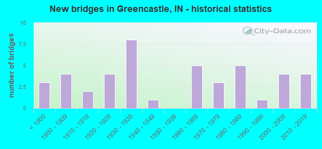
- New bridges - historical statistics
- 3Before 1900
- 41900-1909
- 21910-1919
- 41920-1929
- 81930-1939
- 11940-1949
- 51960-1969
- 31970-1979
- 51980-1989
- 11990-1999
- 42000-2009
- 42010-2019
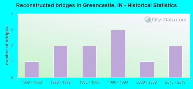
- Reconstructed bridges - Historical Statistics
- 11960-1969
- 21970-1979
- 21980-1989
- 31990-1999
- 12000-2009
- 22010-2019
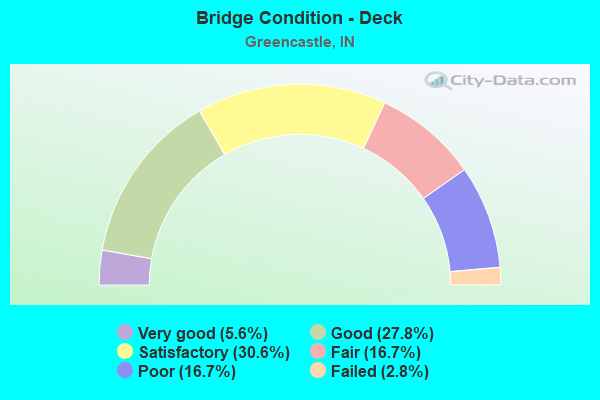
- Bridge Condition - Deck
- 5.6%Very good
- 27.8%Good
- 30.6%Satisfactory
- 16.7%Fair
- 16.7%Poor
- 2.8%Failed
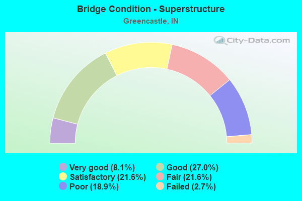
- Bridge Condition - Superstructure
- 8.1%Very good
- 27.0%Good
- 21.6%Satisfactory
- 21.6%Fair
- 18.9%Poor
- 2.7%Failed
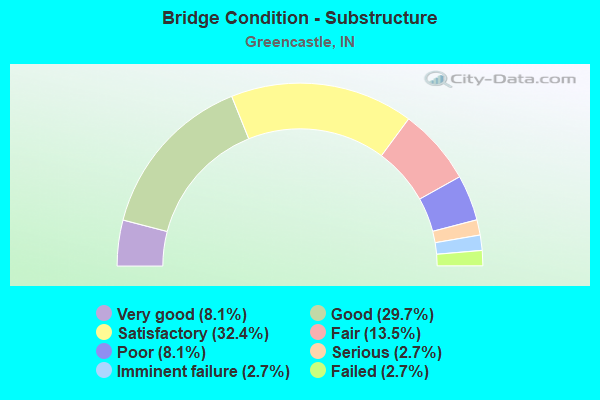
- Bridge Condition - Substructure
- 8.1%Very good
- 29.7%Good
- 32.4%Satisfactory
- 13.5%Fair
- 8.1%Poor
- 2.7%Serious
- 2.7%Imminent failure
- 2.7%Failed
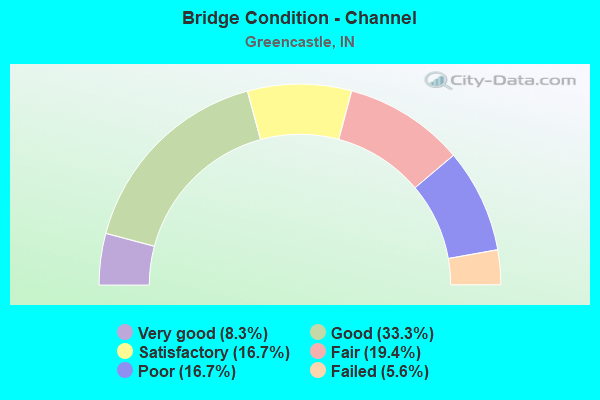
- Bridge Condition - Channel
- 8.3%Very good
- 33.3%Good
- 16.7%Satisfactory
- 19.4%Fair
- 16.7%Poor
- 5.6%Failed
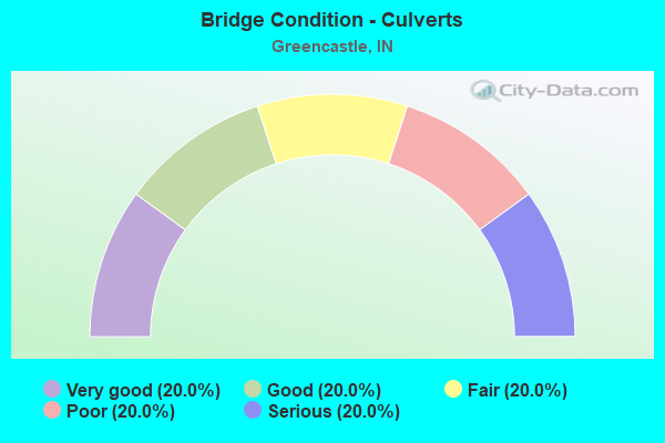
- Bridge Condition - Culverts
- 20.0%Very good
- 20.0%Good
- 20.0%Fair
- 20.0%Poor
- 20.0%Serious
Find on map >> Show street view
Structure Number: 6700256, Location: 00.40 S CR 125 N (Lat: 39.672911, Lng: -86.844211), Route carried "on" structure: County highway 49, Year Built: 2012, Status: Open, Structure Length: 7.98m (26.18ft), Average Daily Traffic: 255 (year 2017), Truck Traffic: 3%, Average Future Daily Traffic: 350 (year 2037), Design Load: HL 93, Features Intersected: BIG WALNUT CREEK, Facility Carried by Structure: CR 25E
Minimum Vertical Clearance: 30+ m (98+ ft), Kilometerpoint: 0.000, Lanes on structure: 2, Owner: County Highway Agency, Approaching Roadway Width: 8.5m (27.9ft), Skew: 3 degrees, Material/Design: Steel continuous, Design/Construction: Stringer/Multi-beam, Number Of Spans In Main Unit: 3, Length of Maximum Span: 30.5m (100.1ft), Curb-To-Curb Width: 8.5m (27.9ft), Out-to-Out Width: 8.6m (28.2ft)
Condition: Deck: Very good, Superstructure: Very good, Substructure: Very good, Channel: Good, Operating Rating: 78.0 metric tons, Method Used To Determine Operating Rating: Load and Resistance Factor (LRFR), Inventory Rating: 64.7 metric tons, Method Used To Determine Inventory Rating: Load and Resistance Factor (LRFR), Structural Evaluation: Equal to present desirable criteria, Waterway Adequacy: Equal to present desirable criteria, Approach Roadway Alignment: Equal to present desirable criteria, Designated Inspection Frequency: Every 24 months, Inspection Date: March 2021, Deck Structure Type: Concrete Cast-file-Place, Wearing Surface/Protective System: Wearing Surface: Monolithic Concrete, Deck Protection: Epoxy Coated Reinforcing
Find on map >> Show street view
Structure Number: 6700258, Location: 01.00 E CR 300 W (Lat: 39.659489, Lng: -86.884639), Route carried "on" structure: County highway , Year Built: 2015, Status: Open, Structure Length: 1.97m (6.46ft), Average Daily Traffic: 1,375 (year 2021), Truck Traffic: 1%, Average Future Daily Traffic: 1,875 (year 2041), Design Load: HL 93, Features Intersected: BRANCH BIG WALNUT CR, Facility Carried by Structure: DUNBAR RD
Minimum Vertical Clearance: 30+ m (98+ ft), Kilometerpoint: 0.000, Lanes on structure: 2, Owner: County Highway Agency, Approaching Roadway Width: 5.2m (17.1ft), Material/Design: Prestressed concrete, Design/Construction: Box Beam or Girders - Single/Spread, Number Of Spans In Main Unit: 1, Length of Maximum Span: 18.9m (62.0ft), Curb-To-Curb Width: 9.3m (30.5ft), Out-to-Out Width: 9.4m (30.8ft)
Condition: Deck: Good, Superstructure: Very good, Substructure: Very good, Channel: Very good, Operating Rating: 40.8 metric tons, Method Used To Determine Operating Rating: Field evaluation and documented engineering judgment, Inventory Rating: 32.7 metric tons, Method Used To Determine Inventory Rating: Field evaluation and documented engineering judgment, Structural Evaluation: Equal to present desirable criteria, Deck Geometry: Somewhat better than minimum adequacy, Waterway Adequacy: Better than present minimum criteria, Approach Roadway Alignment: Equal to present desirable criteria, Designated Inspection Frequency: Every 24 months, Inspection Date: March 2021, Deck Structure Type: Concrete Cast-file-Place, Wearing Surface/Protective System: Wearing Surface: Monolithic Concrete, Deck Protection: Epoxy Coated Reinforcing
Find on map >> Show street view
Structure Number: 6700263, Location: 01.20 N of ALBION POND RD (Lat: 39.676189, Lng: -86.831219), Route carried "on" structure: County highway 55, Year Built: 2016, Status: Open, Structure Length: 6.57m (21.56ft), Average Daily Traffic: 575 (year 2017), Truck Traffic: 3%, Average Future Daily Traffic: 800 (year 2037), Design Load: HL 93, Features Intersected: BIG WALNUT CREEK, Facility Carried by Structure: CR 100E
Minimum Vertical Clearance: 30+ m (98+ ft), Kilometerpoint: 0.000, Lanes on structure: 2, Owner: County Highway Agency, Approaching Roadway Width: 8.5m (27.9ft), Material/Design: Prestressed concrete continuous, Design/Construction: Tee Beam, Number Of Spans In Main Unit: 3, Length of Maximum Span: 29.0m (95.1ft), Curb-To-Curb Width: 8.5m (27.9ft), Out-to-Out Width: 8.7m (28.5ft)
Condition: Deck: Very good, Superstructure: Very good, Substructure: Very good, Channel: Good, Operating Rating: 83.0 metric tons, Method Used To Determine Operating Rating: Load and Resistance Factor (LRFR), Inventory Rating: 68.8 metric tons, Method Used To Determine Inventory Rating: Load and Resistance Factor (LRFR), Structural Evaluation: Equal to present desirable criteria, Deck Geometry: Somewhat better than minimum adequacy, Waterway Adequacy: Better than present minimum criteria, Approach Roadway Alignment: Equal to present desirable criteria, Designated Inspection Frequency: Every 24 months, Inspection Date: March 2021, Deck Structure Type: Concrete Cast-file-Place, Wearing Surface/Protective System: Wearing Surface: Monolithic Concrete, Deck Protection: Epoxy Coated Reinforcing
Find on map >> Show street view
Structure Number: 137, Location: 00.99 W SR 243 (Lat: 39.569431, Lng: -86.882378), Route carried "under" structure: County highway , Year Built: 1985, Structure Length: 0. m, Average Daily Traffic: 132 (year 2006), Truck Traffic: 1%, Features Intersected: SERVICE RD - STATE FARM, Facility Carried by Structure: US 40
Minimum Vertical Clearance: 4.72m (15.49ft), Kilometerpoint: 0.000, Lanes on structure: 4, Lanes under structure: 2, Material/Design: Steel, Design/Construction: Culvert, Length of Maximum Span: 9.9m (32.5ft)
Find on map >> Show street view
Structure Number: 1602, Location: 01.79 N SR 240 (Lat: 39.654611, Lng: -86.866119), Route carried "under" structure: US 231, Year Built: 1906, Structure Length: 0. m, Average Daily Traffic: 9,520 (year 2006), Truck Traffic: 10%, Features Intersected: US 231, Facility Carried by Structure: CSX RR
Minimum Vertical Clearance: 4.57m (14.99ft), Kilometerpoint: 22.418, Lanes under structure: 2, Material/Design: Concrete, Design/Construction: Culvert, Length of Maximum Span: 9.1m (29.9ft)