Bridge Statistics for Grove City, Pennsylvania (PA)
Condition, Traffic, Stress, Structural Evaluation, Project Costs

- New bridges - historical statistics
- 1Before 1900
- 11910-1919
- 21920-1929
- 11930-1939
- 61950-1959
- 311960-1969
- 21970-1979
- 61980-1989
- 61990-1999
- 82000-2009
- 42010-2019
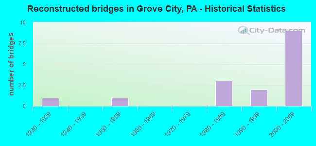
- Reconstructed bridges - Historical Statistics
- 11930-1939
- 01940-1949
- 11950-1959
- 01960-1969
- 01970-1979
- 31980-1989
- 21990-1999
- 92000-2009

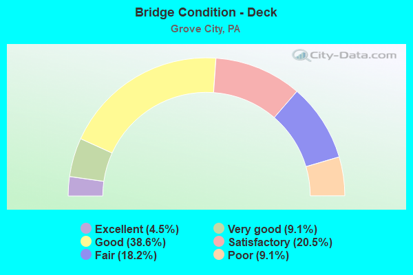
- Bridge Condition - Deck
- 4.5%Excellent
- 9.1%Very good
- 38.6%Good
- 20.5%Satisfactory
- 18.2%Fair
- 9.1%Poor
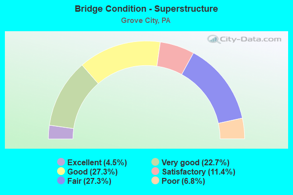
- Bridge Condition - Superstructure
- 4.5%Excellent
- 22.7%Very good
- 27.3%Good
- 11.4%Satisfactory
- 27.3%Fair
- 6.8%Poor
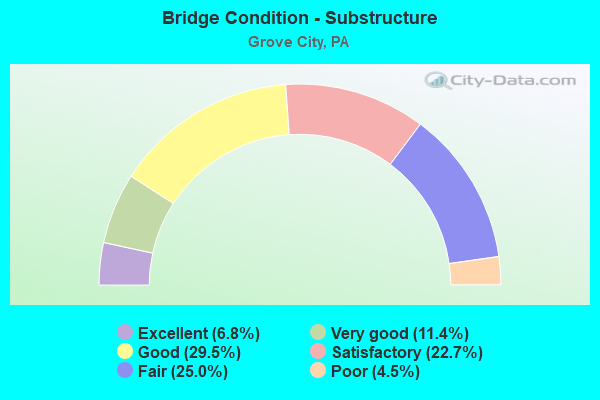
- Bridge Condition - Substructure
- 6.8%Excellent
- 11.4%Very good
- 29.5%Good
- 22.7%Satisfactory
- 25.0%Fair
- 4.5%Poor
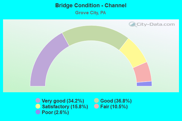
- Bridge Condition - Channel
- 34.2%Very good
- 36.8%Good
- 15.8%Satisfactory
- 10.5%Fair
- 2.6%Poor
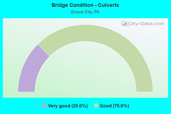
- Bridge Condition - Culverts
- 25.0%Very good
- 75.0%Good
Find on map >> Show street view
Structure Number: 40555, Location: PINE TOWNSHIP (Lat: 41.195514, Lng: -80.124953), Route carried "on" structure: Interstate 80, Year Built: 1999, Status: Open, Structure Length: 11.55m (37.89ft), Average Daily Traffic: 13,333 (year 2021), Truck Traffic: 46%, Average Future Daily Traffic: 16,630 (year 2032), Design Load: HS 25 or greater, Features Intersected: OVER SR 2007,T-439 & RR
Minimum Vertical Clearance: 30+ m (98+ ft), Kilometerpoint: 33.849, Lanes on structure: 2, Lanes under structure: 4, Base Highway Network: Yes, Owner: State Highway Agency, Approaching Roadway Width: 11.6m (38.1ft), Skew: 12 degrees, Material/Design: Prestressed concrete continuous, Design/Construction: Box Beam or Girders - Single/Spread, Number Of Spans In Main Unit: 4, Length of Maximum Span: 30.2m (99.1ft), Curb or Sidewalk Widths: Left: 0.2m (0.7ft), Right: 0.2m (0.7ft), Curb-To-Curb Width: 11.0m (36.1ft), Out-to-Out Width: 12.1m (39.7ft)
Condition: Deck: Good, Superstructure: Good, Substructure: Good, Channel: Very good, Operating Rating: 89.8 metric tons, Method Used To Determine Operating Rating: Load Factor (LF), Inventory Rating: 47.2 metric tons, Method Used To Determine Inventory Rating: Load Factor (LF), Structural Evaluation: Better than present minimum criteria, Deck Geometry: Somewhat better than minimum adequacy, Underclear: Equal to present minimum criteria, Waterway Adequacy: Superior to present desirable criteria, Approach Roadway Alignment: Equal to present desirable criteria, Length Of Structure Improvement: 12.50m (41.01ft), Designated Inspection Frequency: Every 48 months, Inspection Date: July 2019, Deck Structure Type: Concrete Cast-file-Place, Wearing Surface/Protective System: Wearing Surface: Bituminous, Membrane: Preformed Fabric, Deck Protection: Epoxy Coated Reinforcing
Find on map >> Show street view
Structure Number: 40969, Location: UBER ROAD,FINDLEY TWP. (Lat: 41.186469, Lng: -80.163542), Route carried "on" structure: City street 7206, Year Built: 2000, Status: Open, Structure Length: 0.67m (2.20ft), Average Daily Traffic: 47 (year 2018), Truck Traffic: 4%, Average Future Daily Traffic: 70 (year 2038), Design Load: HS 25 or greater, Features Intersected: OVER PINE RUN, Facility Carried by Structure: BRIDGE 2629,T-944
Minimum Vertical Clearance: 30+ m (98+ ft), Kilometerpoint: 0.000, Lanes on structure: 2, Owner: County Highway Agency, Approaching Roadway Width: 7.3m (24.0ft), Skew: 1 degrees, Material/Design: Concrete, Design/Construction: Culvert, Number Of Spans In Main Unit: 1, Length of Maximum Span: 6.1m (20.0ft), Curb-To-Curb Width: 7.3m (24.0ft), Out-to-Out Width: 8.4m (27.6ft)
Condition: Channel: Satisfactory, Culverts: Very good, Operating Rating: 68.9 metric tons, Method Used To Determine Operating Rating: Load Factor (LF), Inventory Rating: 40.8 metric tons, Method Used To Determine Inventory Rating: Load Factor (LF), Structural Evaluation: Equal to present desirable criteria, Deck Geometry: Equal to present minimum criteria, Waterway Adequacy: Equal to present desirable criteria, Approach Roadway Alignment: Equal to present desirable criteria, Length Of Structure Improvement: 0.60m (1.97ft), Designated Inspection Frequency: Every 24 months, Inspection Date: October 2020, Wearing Surface/Protective System: Wearing Surface: Monolithic Concrete, Deck Protection: Epoxy Coated Reinforcing
Find on map >> Show street view
Structure Number: 42413, Location: GROVE CITY BOROUGH (Lat: 41.167089, Lng: -80.079781), Route carried "on" structure: State highway 208, Year Built: 2004, Status: Open, Structure Length: 3.41m (11.19ft), Average Daily Traffic: 3,053 (year 2022), Truck Traffic: 6%, Average Future Daily Traffic: 4,000 (year 2032), Design Load: HL 93, Features Intersected: OVER WOLF CREEK
Minimum Vertical Clearance: 30+ m (98+ ft), Kilometerpoint: 14.750, Lanes on structure: 2, Owner: State Highway Agency, Approaching Roadway Width: 9.8m (32.2ft), Material/Design: Prestressed concrete, Design/Construction: Box Beam or Girders - Single/Spread, Number Of Spans In Main Unit: 1, Length of Maximum Span: 32.6m (107.0ft), Curb or Sidewalk Widths: Left: 0.0m, Right: 1.5m (4.9ft), Curb-To-Curb Width: 10.4m (34.1ft), Out-to-Out Width: 12.2m (40.0ft)
Condition: Deck: Good, Superstructure: Very good, Substructure: Good, Channel: Very good, Operating Rating: 89.8 metric tons, Method Used To Determine Operating Rating: Load and Resistance Factor (LRFR), Inventory Rating: 38.1 metric tons, Method Used To Determine Inventory Rating: Load and Resistance Factor (LRFR), Structural Evaluation: Better than present minimum criteria, Deck Geometry: Somewhat better than minimum adequacy, Waterway Adequacy: Equal to present desirable criteria, Approach Roadway Alignment: Equal to present desirable criteria, Length Of Structure Improvement: 4.30m (14.11ft), Designated Inspection Frequency: Every 48 months, Inspection Date: September 2021, Deck Structure Type: Concrete Cast-file-Place, Wearing Surface/Protective System: Wearing Surface: Monolithic Concrete, Deck Protection: Epoxy Coated Reinforcing
Find on map >> Show street view
Structure Number: 44246, Location: SPRINGFIELD TOWNSHIP (Lat: 41.143333, Lng: -80.151667), Route carried "on" structure: State highway 208, Year Built: 2007, Status: Open, Structure Length: 6.86m (22.51ft), Average Daily Traffic: 12,928 (year 2022), Truck Traffic: 5%, Average Future Daily Traffic: 12,430 (year 2032), Design Load: HL 93, Features Intersected: OVER I-79,NB/SB
Minimum Vertical Clearance: 30+ m (98+ ft), Kilometerpoint: 8.269, Lanes on structure: 5, Lanes under structure: 4, Base Highway Network: Yes, Owner: State Highway Agency, Approaching Roadway Width: 27.1m (88.9ft), Material/Design: Prestressed concrete continuous, Design/Construction: Box Beam or Girders - Single/Spread, Number Of Spans In Main Unit: 2, Length of Maximum Span: 34.1m (111.9ft), Curb or Sidewalk Widths: Left: 0.2m (0.7ft), Right: 0.2m (0.7ft), Curb-To-Curb Width: 27.0m (88.6ft), Out-to-Out Width: 27.9m (91.5ft)
Condition: Deck: Good, Superstructure: Very good, Substructure: Very good, Operating Rating: 76.2 metric tons, Method Used To Determine Operating Rating: Load and Resistance Factor (LRFR), Inventory Rating: 37.2 metric tons, Method Used To Determine Inventory Rating: Load and Resistance Factor (LRFR), Structural Evaluation: Equal to present desirable criteria, Deck Geometry: Superior to present desirable criteria, Underclear: Better than present minimum criteria, Approach Roadway Alignment: Equal to present desirable criteria, Designated Inspection Frequency: Every 24 months, Inspection Date: October 2021, Deck Structure Type: Concrete Cast-file-Place, Wearing Surface/Protective System: Wearing Surface: Monolithic Concrete, Deck Protection: Epoxy Coated Reinforcing
Find on map >> Show street view
Structure Number: 44254, Location: _CHESTNUT STREET, GROVE C (Lat: 41.163528, Lng: -80.080447), Route carried "on" structure: County highway , Year Built: 2007, Status: Open, Structure Length: 9.30m (30.51ft), Average Daily Traffic: 1,505 (year 2019), Truck Traffic: 4%, Average Future Daily Traffic: 2,110 (year 2039), Design Load: HL 93, Features Intersected: OVER WOLF CREEK, Facility Carried by Structure: BRIDGE 3116
Minimum Vertical Clearance: 30+ m (98+ ft), Kilometerpoint: 0.000, Lanes on structure: 2, Owner: County Highway Agency, Approaching Roadway Width: 7.3m (24.0ft), Material/Design: Steel continuous, Design/Construction: Stringer/Multi-beam, Number Of Spans In Main Unit: 2, Length of Maximum Span: 45.7m (149.9ft), Curb or Sidewalk Widths: Left: 1.5m (4.9ft), Right: 0.0m, Curb-To-Curb Width: 7.3m (24.0ft), Out-to-Out Width: 9.7m (31.8ft)
Condition: Deck: Good, Superstructure: Very good, Substructure: Good, Channel: Very good, Operating Rating: 62.6 metric tons, Method Used To Determine Operating Rating: Load and Resistance Factor (LRFR), Inventory Rating: 48.1 metric tons, Method Used To Determine Inventory Rating: Load and Resistance Factor (LRFR), Structural Evaluation: Better than present minimum criteria, Deck Geometry: Meets minimum limits, Waterway Adequacy: Superior to present desirable criteria, Approach Roadway Alignment: Equal to present desirable criteria, Designated Inspection Frequency: Every 24 months, Inspection Date: October 2021, Deck Structure Type: Concrete Cast-file-Place, Wearing Surface/Protective System: Wearing Surface: Monolithic Concrete, Deck Protection: Epoxy Coated Reinforcing
Find on map >> Show street view
Structure Number: 44283, Location: PINE TOWNSHIP (Lat: 41.127889, Lng: -80.096633), Route carried "on" structure: State highway , Year Built: 2007, Status: Open, Structure Length: 1.07m (3.51ft), Average Daily Traffic: 2,813 (year 2021), Truck Traffic: 5%, Average Future Daily Traffic: 3,172 (year 2032), Design Load: HL 93, Features Intersected: LAKE BARMORE OUTLET, Facility Carried by Structure: SR 2025,N.LIBERTY
Minimum Vertical Clearance: 30+ m (98+ ft), Kilometerpoint: 0.019, Lanes on structure: 2, Owner: State Highway Agency, Approaching Roadway Width: 6.1m (20.0ft), Material/Design: Concrete, Design/Construction: Culvert, Number Of Spans In Main Unit: 2, Length of Maximum Span: 5.2m (17.1ft), Curb-To-Curb Width: 9.3m (30.5ft), Out-to-Out Width: 10.1m (33.1ft)
Condition: Channel: Good, Culverts: Good, Operating Rating: 63.5 metric tons, Method Used To Determine Operating Rating: Load and Resistance Factor (LRFR), Inventory Rating: 49.0 metric tons, Method Used To Determine Inventory Rating: Load and Resistance Factor (LRFR), Structural Evaluation: Better than present minimum criteria, Deck Geometry: Meets minimum limits, Waterway Adequacy: Better than present minimum criteria, Approach Roadway Alignment: Equal to present desirable criteria, Designated Inspection Frequency: Every 48 months, Inspection Date: May 2019
Find on map >> Show street view
Structure Number: 44958, Location: DIAMOND ROAD, PINE TWP (Lat: 41.186472, Lng: -80.053925), Route carried "on" structure: City street , Year Built: 2008, Status: Open, Structure Length: 0.85m (2.79ft), Average Daily Traffic: 247 (year 2016), Truck Traffic: 4%, Average Future Daily Traffic: 350 (year 2036), Design Load: HL 93, Features Intersected: BR. WOLF CREEK, Facility Carried by Structure: BRIDGE 3108, T-878
Minimum Vertical Clearance: 30+ m (98+ ft), Kilometerpoint: 0.000, Lanes on structure: 2, Owner: County Highway Agency, Approaching Roadway Width: 6.1m (20.0ft), Material/Design: Prestressed concrete, Design/Construction: Box Beam or Girders - Multiple, Number Of Spans In Main Unit: 1, Length of Maximum Span: 8.2m (26.9ft), Curb-To-Curb Width: 7.3m (24.0ft), Out-to-Out Width: 8.6m (28.2ft)
Condition: Deck: Very good, Superstructure: Very good, Substructure: Very good, Channel: Good, Operating Rating: 88.9 metric tons, Method Used To Determine Operating Rating: Load and Resistance Factor (LRFR), Inventory Rating: 48.1 metric tons, Method Used To Determine Inventory Rating: Load and Resistance Factor (LRFR), Structural Evaluation: Equal to present desirable criteria, Deck Geometry: Somewhat better than minimum adequacy, Waterway Adequacy: Equal to present desirable criteria, Approach Roadway Alignment: Equal to present desirable criteria, Designated Inspection Frequency: Every 24 months, Inspection Date: August 2020, Deck Structure Type: Concrete Cast-file-Place, Wearing Surface/Protective System: Wearing Surface: Monolithic Concrete, Deck Protection: Epoxy Coated Reinforcing
Find on map >> Show street view
Structure Number: 45924, Location: LIBERTY TOWNSHIP (Lat: 41.123475, Lng: -80.125036), Route carried "on" structure: State highway 258, Year Built: 2010, Status: Open, Structure Length: 1.77m (5.81ft), Average Daily Traffic: 2,979 (year 2022), Truck Traffic: 4%, Average Future Daily Traffic: 2,905 (year 2032), Design Load: HL 93, Features Intersected: BLACK RUN, Facility Carried by Structure: BUTLER PIKE
Minimum Vertical Clearance: 30+ m (98+ ft), Kilometerpoint: 5.597, Lanes on structure: 2, Owner: State Highway Agency, Approaching Roadway Width: 6.1m (20.0ft), Material/Design: Prestressed concrete, Design/Construction: Box Beam or Girders - Single/Spread, Number Of Spans In Main Unit: 1, Length of Maximum Span: 16.8m (55.1ft), Curb or Sidewalk Widths: Left: 0.2m (0.7ft), Right: 0.2m (0.7ft), Curb-To-Curb Width: 8.5m (27.9ft), Out-to-Out Width: 9.4m (30.8ft)
Condition: Deck: Good, Superstructure: Very good, Substructure: Very good, Channel: Very good, Operating Rating: 65.3 metric tons, Method Used To Determine Operating Rating: Load and Resistance Factor (LRFR), Inventory Rating: 39.9 metric tons, Method Used To Determine Inventory Rating: Load and Resistance Factor (LRFR), Structural Evaluation: Equal to present desirable criteria, Deck Geometry: Meets minimum limits, Waterway Adequacy: Better than present minimum criteria, Approach Roadway Alignment: Equal to present desirable criteria, Designated Inspection Frequency: Every 48 months, Inspection Date: May 2019, Deck Structure Type: Concrete Cast-file-Place, Wearing Surface/Protective System: Wearing Surface: Monolithic Concrete, Deck Protection: Epoxy Coated Reinforcing
Find on map >> Show street view
Structure Number: 46042, Location: LIBERTY TWP (Lat: 41.115508, Lng: -80.117753), Route carried "on" structure: State highway 258, Year Built: 2010, Status: Open, Structure Length: 1.34m (4.40ft), Average Daily Traffic: 2,979 (year 2022), Truck Traffic: 4%, Average Future Daily Traffic: 2,905 (year 2032), Design Load: HL 93, Features Intersected: OVER TINKERS RUN
Minimum Vertical Clearance: 30+ m (98+ ft), Kilometerpoint: 4.522, Lanes on structure: 2, Owner: State Highway Agency, Approaching Roadway Width: 7.3m (24.0ft), Material/Design: Prestressed concrete, Design/Construction: Box Beam or Girders - Single/Spread, Number Of Spans In Main Unit: 1, Length of Maximum Span: 12.2m (40.0ft), Curb or Sidewalk Widths: Left: 0.2m (0.7ft), Right: 0.2m (0.7ft), Curb-To-Curb Width: 8.6m (28.2ft), Out-to-Out Width: 9.6m (31.5ft)
Condition: Deck: Good, Superstructure: Good, Substructure: Excellent, Channel: Very good, Operating Rating: 67.1 metric tons, Method Used To Determine Operating Rating: Load and Resistance Factor (LRFR), Inventory Rating: 51.7 metric tons, Method Used To Determine Inventory Rating: Load and Resistance Factor (LRFR), Structural Evaluation: Better than present minimum criteria, Deck Geometry: Meets minimum limits, Waterway Adequacy: Superior to present desirable criteria, Approach Roadway Alignment: Equal to present desirable criteria, Designated Inspection Frequency: Every 48 months, Inspection Date: April 2020, Deck Structure Type: Concrete Cast-file-Place, Wearing Surface/Protective System: Wearing Surface: Monolithic Concrete, Deck Protection: Epoxy Coated Reinforcing
Find on map >> Show street view
Structure Number: 48757, Location: PINE TWP (Lat: 41.134936, Lng: -80.075800), Route carried "on" structure: State highway 173, Year Built: 2014, Status: Open, Structure Length: 1.92m (6.30ft), Average Daily Traffic: 3,909 (year 2021), Truck Traffic: 7%, Average Future Daily Traffic: 6,576 (year 2032), Design Load: HL 93, Features Intersected: SWAMP RUN
Minimum Vertical Clearance: 30+ m (98+ ft), Kilometerpoint: 2.395, Lanes on structure: 2, Base Highway Network: Yes, Owner: State Highway Agency, Approaching Roadway Width: 9.8m (32.2ft), Material/Design: Prestressed concrete, Design/Construction: Box Beam or Girders - Single/Spread, Number Of Spans In Main Unit: 1, Length of Maximum Span: 18.3m (60.0ft), Curb or Sidewalk Widths: Left: 0.1m (0.3ft), Right: 0.1m (0.3ft), Curb-To-Curb Width: 9.8m (32.2ft), Out-to-Out Width: 10.9m (35.8ft)
Condition: Deck: Excellent, Superstructure: Excellent, Substructure: Excellent, Channel: Very good, Operating Rating: 47.3 metric tons, Method Used To Determine Operating Rating: Assigned ratings based on Load and Resistance Factor Design (LRFD) reported by rating factor (RF) using HL93 loadings, Inventory Rating: 36.3 metric tons, Method Used To Determine Inventory Rating: Assigned ratings based on Load and Resistance Factor Design (LRFD) reported by rating factor (RF) using HL93 loadings, Structural Evaluation: Superior to present desirable criteria, Deck Geometry: Meets minimum limits, Waterway Adequacy: Superior to present desirable criteria, Approach Roadway Alignment: Equal to present desirable criteria, Designated Inspection Frequency: Every 48 months, Inspection Date: October 2020, Deck Structure Type: Concrete Cast-file-Place, Wearing Surface/Protective System: Wearing Surface: Bituminous, Membrane: Preformed Fabric, Deck Protection: Epoxy Coated Reinforcing
Find on map >> Show street view
Structure Number: 52699, Location: PINE TOWNSHIP (Lat: 41.192061, Lng: -80.121825), Route carried "on" structure: State highway , Year Built: 2015, Status: Open, Structure Length: 4.45m (14.60ft), Average Daily Traffic: 1,708 (year 2021), Truck Traffic: 4%, Average Future Daily Traffic: 2,453 (year 2032), Design Load: HL 93, Features Intersected: OVER B.&L.E. R.R., Facility Carried by Structure: SR2005IRISHTOWN RD
Minimum Vertical Clearance: 30+ m (98+ ft), Kilometerpoint: 4.038, Lanes on structure: 2, Owner: State Highway Agency, Approaching Roadway Width: 7.3m (24.0ft), Material/Design: Steel, Design/Construction: Stringer/Multi-beam, Number Of Spans In Main Unit: 1, Length of Maximum Span: 43.6m (143.0ft), Curb or Sidewalk Widths: Left: 0.2m (0.7ft), Right: 0.2m (0.7ft), Curb-To-Curb Width: 8.5m (27.9ft), Out-to-Out Width: 9.5m (31.2ft)
Condition: Deck: Excellent, Superstructure: Excellent, Substructure: Excellent, Operating Rating: 68.4 metric tons, Method Used To Determine Operating Rating: Assigned ratings based on Load and Resistance Factor Design (LRFD) reported by rating factor (RF) using HL93 loadings, Inventory Rating: 45.0 metric tons, Method Used To Determine Inventory Rating: Assigned ratings based on Load and Resistance Factor Design (LRFD) reported by rating factor (RF) using HL93 loadings, Structural Evaluation: Superior to present desirable criteria, Deck Geometry: Somewhat better than minimum adequacy, Underclear: High priority of corrective action, Approach Roadway Alignment: Equal to present desirable criteria, Designated Inspection Frequency: Every 48 months, Inspection Date: November 2019, Deck Structure Type: Concrete Cast-file-Place, Wearing Surface/Protective System: Wearing Surface: Epoxy Overlay, Membrane: Epoxy, Deck Protection: Epoxy Coated Reinforcing
Find on map >> Show street view
Structure Number: 22383, Location: PLAIN GROVE TWP O/I79 (Lat: 41.107558, Lng: -80.145169), Route carried "under" structure: Interstate 79, Year Built: 1963, Structure Length: 0. m, Average Daily Traffic: 11,309 (year 2021), Truck Traffic: 26%, Features Intersected: I-79, Facility Carried by Structure: BRENT NORTH LIB RD
Minimum Vertical Clearance: 4.93m (16.17ft), Kilometerpoint: 8.129, Lanes on structure: 2, Lanes under structure: 4, Material/Design: Prestressed concrete, Design/Construction: Box Beam or Girders - Single/Spread, Length of Maximum Span: 20.1m (65.9ft)
Find on map >> Show street view
Structure Number: 22383, Location: PLAIN GROVE TWP O/I79 (Lat: 41.107558, Lng: -80.145169), Route carried "under" structure: Interstate 79, Year Built: 1963, Structure Length: 0. m, Average Daily Traffic: 11,625 (year 2021), Truck Traffic: 21%, Features Intersected: I-79, Facility Carried by Structure: BRENT NORTH LIB RD
Minimum Vertical Clearance: 5.11m (16.77ft), Kilometerpoint: 8.093, Lanes on structure: 2, Lanes under structure: 4, Material/Design: Prestressed concrete, Design/Construction: Box Beam or Girders - Single/Spread, Length of Maximum Span: 20.1m (65.9ft)
Find on map >> Show street view
Structure Number: 25678, Location: FINDLEY TOWNSHIP (Lat: 41.200000, Lng: -80.156667), Route carried "under" structure: Interstate 79, Year Built: 1963, Structure Length: 0. m, Average Daily Traffic: 9,615 (year 2021), Truck Traffic: 19%, Features Intersected: OVER SR 79 NB / SB, Facility Carried by Structure: SR 58,GROVE CITY
Minimum Vertical Clearance: 5.39m (17.68ft), Kilometerpoint: 9.069, Lanes on structure: 4, Lanes under structure: 6, Material/Design: Prestressed concrete, Design/Construction: Box Beam or Girders - Single/Spread, Length of Maximum Span: 23.5m (77.1ft)
Find on map >> Show street view
Structure Number: 25678, Location: FINDLEY TOWNSHIP (Lat: 41.200000, Lng: -80.156667), Route carried "under" structure: Interstate 79, Year Built: 1963, Structure Length: 0. m, Average Daily Traffic: 9,619 (year 2021), Truck Traffic: 20%, Features Intersected: OVER SR 79 NB / SB, Facility Carried by Structure: SR 58,GROVE CITY
Minimum Vertical Clearance: 5.16m (16.93ft), Kilometerpoint: 9.064, Lanes on structure: 4, Lanes under structure: 6, Material/Design: Prestressed concrete, Design/Construction: Box Beam or Girders - Single/Spread, Length of Maximum Span: 23.5m (77.1ft)
Find on map >> Show street view
Structure Number: 25737, Location: FINDLEY TOWNSHIP (Lat: 41.198042, Lng: -80.159789), Route carried "under" structure: Interstate 80, Year Built: 1965, Structure Length: 0. m, Average Daily Traffic: 13,373 (year 2021), Truck Traffic: 48%, Features Intersected: OVER SR 80,EB/WB, Facility Carried by Structure: SR 79,NB
Minimum Vertical Clearance: 5.26m (17.26ft), Kilometerpoint: 30.584, Lanes on structure: 3, Lanes under structure: 6, Material/Design: Prestressed concrete, Design/Construction: Box Beam or Girders - Single/Spread, Length of Maximum Span: 21.0m (68.9ft)
Find on map >> Show street view
Structure Number: 25737, Location: FINDLEY TOWNSHIP (Lat: 41.198042, Lng: -80.159789), Route carried "under" structure: Interstate 80, Year Built: 1965, Structure Length: 0. m, Average Daily Traffic: 13,333 (year 2021), Truck Traffic: 46%, Features Intersected: OVER SR 80,EB/WB, Facility Carried by Structure: SR 79,NB
Minimum Vertical Clearance: 5.22m (17.13ft), Kilometerpoint: 30.579, Lanes on structure: 3, Lanes under structure: 6, Material/Design: Prestressed concrete, Design/Construction: Box Beam or Girders - Single/Spread, Length of Maximum Span: 21.0m (68.9ft)
Find on map >> Show street view
Structure Number: 25739, Location: FINDLEY TOWNSHIP (Lat: 41.198197, Lng: -80.160158), Route carried "under" structure: Interstate 80, Year Built: 1965, Structure Length: 0. m, Average Daily Traffic: 13,373 (year 2021), Truck Traffic: 48%, Features Intersected: OVER SR 80,EB/WB, Facility Carried by Structure: SR 79,SB
Minimum Vertical Clearance: 5.12m (16.80ft), Kilometerpoint: 30.584, Lanes on structure: 3, Lanes under structure: 6, Material/Design: Prestressed concrete, Design/Construction: Box Beam or Girders - Single/Spread, Length of Maximum Span: 21.0m (68.9ft)
Find on map >> Show street view
Structure Number: 25739, Location: FINDLEY TOWNSHIP (Lat: 41.198197, Lng: -80.160158), Route carried "under" structure: Interstate 80, Year Built: 1965, Structure Length: 0. m, Average Daily Traffic: 13,333 (year 2021), Truck Traffic: 46%, Features Intersected: OVER SR 80,EB/WB, Facility Carried by Structure: SR 79,SB
Minimum Vertical Clearance: 5.23m (17.16ft), Kilometerpoint: 30.579, Lanes on structure: 3, Lanes under structure: 6, Material/Design: Prestressed concrete, Design/Construction: Box Beam or Girders - Single/Spread, Length of Maximum Span: 21.0m (68.9ft)
Find on map >> Show street view
Structure Number: 25802, Location: FINDLEY TOWNSHIP (Lat: 41.198097, Lng: -80.147383), Route carried "under" structure: Interstate 80, Year Built: 1965, Structure Length: 0. m, Average Daily Traffic: 13,373 (year 2021), Truck Traffic: 48%, Features Intersected: OVER SR 80,EB/WB, Facility Carried by Structure: SR 2101,HARTWICK R
Minimum Vertical Clearance: 4.93m (16.17ft), Kilometerpoint: 31.408, Lanes on structure: 2, Lanes under structure: 4, Material/Design: Prestressed concrete, Design/Construction: Box Beam or Girders - Single/Spread, Length of Maximum Span: 17.4m (57.1ft)
Find on map >> Show street view
Structure Number: 25802, Location: FINDLEY TOWNSHIP (Lat: 41.198097, Lng: -80.147383), Route carried "under" structure: Interstate 80, Year Built: 1965, Structure Length: 0. m, Average Daily Traffic: 13,333 (year 2021), Truck Traffic: 46%, Features Intersected: OVER SR 80,EB/WB, Facility Carried by Structure: SR 2101,HARTWICK R
Minimum Vertical Clearance: 5.62m (18.44ft), Kilometerpoint: 31.373, Lanes on structure: 2, Lanes under structure: 4, Material/Design: Prestressed concrete, Design/Construction: Box Beam or Girders - Single/Spread, Length of Maximum Span: 17.4m (57.1ft)
Find on map >> Show street view
Structure Number: 25808, Location: WOLF CREEK TOWNSHIP (Lat: 41.201628, Lng: -80.074608), Route carried "under" structure: State highway 173, Year Built: 1965, Structure Length: 0. m, Average Daily Traffic: 2,730 (year 2022), Truck Traffic: 9%, Features Intersected: OVER SR 173,GROVE CITY, Facility Carried by Structure: SR 80,EB
Minimum Vertical Clearance: 5.33m (17.49ft), Kilometerpoint: 10.726, Lanes on structure: 3, Lanes under structure: 2, Material/Design: Prestressed concrete continuous, Design/Construction: Box Beam or Girders - Single/Spread, Length of Maximum Span: 13.7m (44.9ft)
Find on map >> Show street view
Structure Number: 2581, Location: WOLF CREEK TOWNSHIP (Lat: 41.201900, Lng: -80.074419), Route carried "under" structure: State highway 173, Year Built: 1965, Structure Length: 0. m, Average Daily Traffic: 2,730 (year 2022), Truck Traffic: 9%, Features Intersected: OVER SR 173,GROVE CITY, Facility Carried by Structure: SR 80,WB
Minimum Vertical Clearance: 5.27m (17.29ft), Kilometerpoint: 10.726, Lanes on structure: 2, Lanes under structure: 2, Material/Design: Prestressed concrete continuous, Design/Construction: Box Beam or Girders - Single/Spread, Length of Maximum Span: 13.7m (44.9ft)
Find on map >> Show street view
Structure Number: 2595, Location: SPRINGFIELD TOWNSHIP (Lat: 41.160042, Lng: -80.159658), Route carried "under" structure: Interstate 79, Year Built: 1963, Structure Length: 0. m, Average Daily Traffic: 9,615 (year 2021), Truck Traffic: 19%, Features Intersected: OVER SR 79,NB/SB, Facility Carried by Structure: SR 2006,BLACKTOWN
Minimum Vertical Clearance: 5.11m (16.77ft), Kilometerpoint: 5.053, Lanes on structure: 2, Lanes under structure: 4, Material/Design: Prestressed concrete, Design/Construction: Box Beam or Girders - Single/Spread, Length of Maximum Span: 19.5m (64.0ft)
Find on map >> Show street view
Structure Number: 2595, Location: SPRINGFIELD TOWNSHIP (Lat: 41.160042, Lng: -80.159658), Route carried "under" structure: Interstate 79, Year Built: 1963, Structure Length: 0. m, Average Daily Traffic: 9,619 (year 2021), Truck Traffic: 20%, Features Intersected: OVER SR 79,NB/SB, Facility Carried by Structure: SR 2006,BLACKTOWN
Minimum Vertical Clearance: 5.03m (16.50ft), Kilometerpoint: 4.994, Lanes on structure: 2, Lanes under structure: 4, Material/Design: Prestressed concrete, Design/Construction: Box Beam or Girders - Single/Spread, Length of Maximum Span: 19.5m (64.0ft)
Find on map >> Show street view
Structure Number: 40212, Location: PINE TOWNSHIP (Lat: 41.195225, Lng: -80.124111), Route carried "under" structure: State highway , Year Built: 1998, Structure Length: 0. m, Average Daily Traffic: 1,279 (year 2022), Truck Traffic: 5%, Features Intersected: OVER SR 2007,T-439 & RR, Facility Carried by Structure: SR 80,EB
Minimum Vertical Clearance: 4.44m (14.57ft), Kilometerpoint: 0.063, Lanes on structure: 2, Lanes under structure: 4, Material/Design: Prestressed concrete continuous, Design/Construction: Box Beam or Girders - Single/Spread, Length of Maximum Span: 30.2m (99.1ft)
Find on map >> Show street view
Structure Number: 40212, Location: PINE TOWNSHIP (Lat: 41.195225, Lng: -80.124111), Route carried "under" structure: City street 7219, Year Built: 1998, Structure Length: 0. m, Average Daily Traffic: 50 (year 2001), Features Intersected: OVER SR 2007,T-439 & RR, Facility Carried by Structure: SR 80,EB
Minimum Vertical Clearance: 6.27m (20.57ft), Kilometerpoint: 0.000, Lanes on structure: 2, Lanes under structure: 4, Material/Design: Prestressed concrete continuous, Design/Construction: Box Beam or Girders - Single/Spread, Length of Maximum Span: 30.2m (99.1ft)
Find on map >> Show street view
Structure Number: 40555, Location: PINE TOWNSHIP (Lat: 41.195514, Lng: -80.124953), Route carried "under" structure: State highway , Year Built: 1999, Structure Length: 0. m, Average Daily Traffic: 1,279 (year 2022), Truck Traffic: 5%, Features Intersected: OVER SR 2007,T-439 & RR, Facility Carried by Structure: SR 80,WB
Minimum Vertical Clearance: 4.62m (15.16ft), Kilometerpoint: 0.063, Lanes on structure: 2, Lanes under structure: 4, Material/Design: Prestressed concrete continuous, Design/Construction: Box Beam or Girders - Single/Spread, Length of Maximum Span: 30.2m (99.1ft)
Find on map >> Show street view
Structure Number: 40555, Location: PINE TOWNSHIP (Lat: 41.195514, Lng: -80.124953), Route carried "under" structure: City street 7206, Year Built: 1999, Structure Length: 0. m, Average Daily Traffic: 50 (year 2003), Features Intersected: OVER SR 2007,T-439 & RR, Facility Carried by Structure: SR 80,WB
Minimum Vertical Clearance: 4.72m (15.49ft), Kilometerpoint: 0.000, Lanes on structure: 2, Lanes under structure: 4, Material/Design: Prestressed concrete continuous, Design/Construction: Box Beam or Girders - Single/Spread, Length of Maximum Span: 30.2m (99.1ft)
Find on map >> Show street view
Structure Number: 44246, Location: SPRINGFIELD TOWNSHIP (Lat: 41.143333, Lng: -80.151667), Route carried "under" structure: Interstate 79, Year Built: 2007, Structure Length: 0. m, Average Daily Traffic: 9,615 (year 2021), Truck Traffic: 19%, Features Intersected: OVER I-79,NB/SB, Facility Carried by Structure: SR 208,GROVE CITY
Minimum Vertical Clearance: 5.15m (16.90ft), Kilometerpoint: 3.444, Lanes on structure: 5, Lanes under structure: 2, Material/Design: Prestressed concrete continuous, Design/Construction: Box Beam or Girders - Single/Spread, Length of Maximum Span: 34.1m (111.9ft)
Find on map >> Show street view
Structure Number: 44246, Location: SPRINGFIELD TOWNSHIP (Lat: 41.143333, Lng: -80.151667), Route carried "under" structure: Interstate 79, Year Built: 2007, Structure Length: 0. m, Average Daily Traffic: 9,619 (year 2021), Truck Traffic: 20%, Features Intersected: OVER I-79,NB/SB, Facility Carried by Structure: SR 208,GROVE CITY
Minimum Vertical Clearance: 5.15m (16.90ft), Kilometerpoint: 3.392, Lanes on structure: 5, Lanes under structure: 2, Material/Design: Prestressed concrete continuous, Design/Construction: Box Beam or Girders - Single/Spread, Length of Maximum Span: 34.1m (111.9ft)