Bridge Statistics for Hagerstown, Maryland (MD)
Condition, Traffic, Stress, Structural Evaluation, Project Costs
- National Bridge Inventory (NBI) Statistics
- 57Number of bridges
- 702ft / 214mTotal length
- $7,874,000Total costs
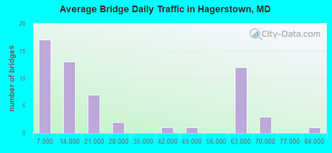
- 1,428,387Total average daily traffic
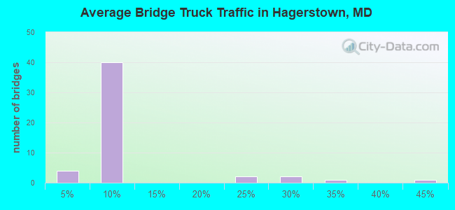
- 123,713Total average daily truck traffic
- National Bridge Inventory (NBI) Registered Bridges for Hagerstown
- No street view available for this location
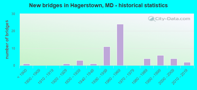
- New bridges - historical statistics
- 1Before 1900
- 11920-1929
- 31930-1939
- 11940-1949
- 111950-1959
- 241960-1969
- 41980-1989
- 61990-1999
- 42000-2009
- 22010-2019
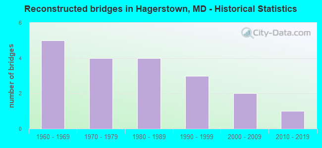
- Reconstructed bridges - Historical Statistics
- 51960-1969
- 41970-1979
- 41980-1989
- 31990-1999
- 22000-2009
- 12010-2019
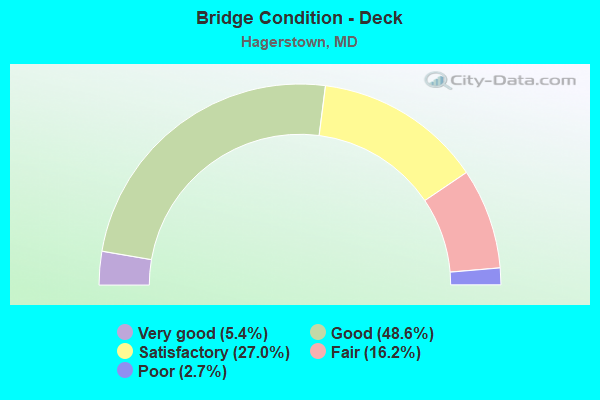
- Bridge Condition - Deck
- 5.4%Very good
- 48.6%Good
- 27.0%Satisfactory
- 16.2%Fair
- 2.7%Poor
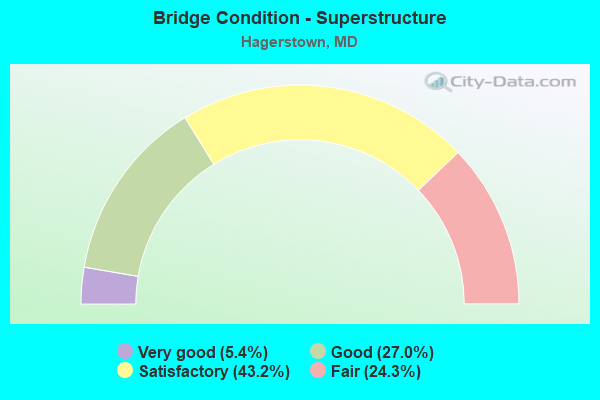
- Bridge Condition - Superstructure
- 5.4%Very good
- 27.0%Good
- 43.2%Satisfactory
- 24.3%Fair
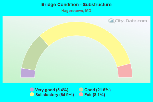
- Bridge Condition - Substructure
- 5.4%Very good
- 21.6%Good
- 64.9%Satisfactory
- 8.1%Fair
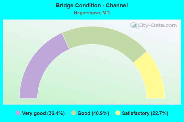
- Bridge Condition - Channel
- 36.4%Very good
- 40.9%Good
- 22.7%Satisfactory
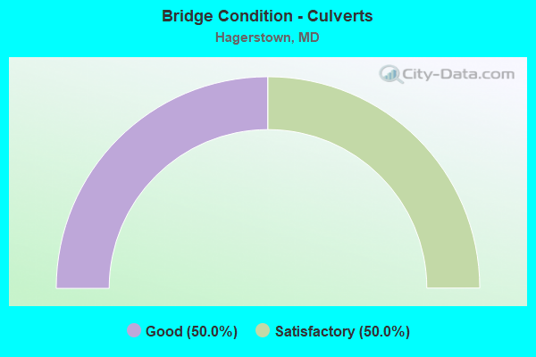
- Bridge Condition - Culverts
- 50.0%Good
- 50.0%Satisfactory
Find on map >> Show street view
Structure Number: 200000W-H-4001, Location: 0.5 MI E CANNON AVE (Lat: 39.642081, Lng: -77.704272), Route carried "on" structure: State highway 64, Year Built: 1929, Year Reconstructed: 1984, Status: Posted for load, Structure Length: 0.67m (2.20ft), Average Daily Traffic: 9,505 (year 2009), Truck Traffic: 5%, Average Future Daily Traffic: 16,364 (year 2031), Design Load: HS 20, Features Intersected: HAMILTON RUN, Facility Carried by Structure: JEFFERSON BOULEVAR
Minimum Vertical Clearance: 30+ m (98+ ft), Kilometerpoint: 0.853, Lanes on structure: 2, Owner: City or Municipal Highway Agency, Approaching Roadway Width: 10.1m (33.1ft), Material/Design: Concrete, Design/Construction: Slab, Number Of Spans In Main Unit: 1, Length of Maximum Span: 6.1m (20.0ft), Curb or Sidewalk Widths: Left: 1.2m (3.9ft), Right: 1.2m (3.9ft), Curb-To-Curb Width: 9.1m (29.9ft), Out-to-Out Width: 13.1m (43.0ft)
Condition: Deck: Satisfactory, Superstructure: Fair, Substructure: Satisfactory, Channel: Good, Operating Rating: 44.0 metric tons, Method Used To Determine Operating Rating: Load Factor (LF), Inventory Rating: 26.3 metric tons, Method Used To Determine Inventory Rating: Load Factor (LF), Structural Evaluation: Somewhat better than minimum adequacy, Deck Geometry: High priority of corrective action, Waterway Adequacy: Equal to present minimum criteria, Approach Roadway Alignment: Equal to present desirable criteria, Designated Inspection Frequency: Every 24 months, Inspection Date: January 2022, Deck Structure Type: Concrete Cast-file-Place, Wearing Surface/Protective System: Wearing Surface: Monolithic Concrete
Find on map >> Show street view
Structure Number: 200000W-H-4101, Location: AT INT OF BROOKLINE AVE (Lat: 39.645292, Lng: -77.703411), Route carried "on" structure: City street 2210, Year Built: 1957, Status: Posted for load, Structure Length: 0.76m (2.49ft), Average Daily Traffic: 2,518 (year 2015), Truck Traffic: 5%, Average Future Daily Traffic: 3,470 (year 2037), Design Load: H 15, Features Intersected: HAMILTON RUN, Facility Carried by Structure: SECURITY ROAD
Minimum Vertical Clearance: 30+ m (98+ ft), Kilometerpoint: 0.225, Lanes on structure: 2, Owner: City or Municipal Highway Agency, Approaching Roadway Width: 8.5m (27.9ft), Skew: 1 degrees, Material/Design: Concrete, Design/Construction: Slab, Number Of Spans In Main Unit: 1, Length of Maximum Span: 7.0m (23.0ft), Curb or Sidewalk Widths: Left: 0.7m (2.3ft), Right: 0.7m (2.3ft), Curb-To-Curb Width: 8.5m (27.9ft), Out-to-Out Width: 10.4m (34.1ft)
Condition: Deck: Fair, Superstructure: Fair, Substructure: Satisfactory, Channel: Good, Operating Rating: 49.0 metric tons, Method Used To Determine Operating Rating: Load Factor (LF), Inventory Rating: 29.5 metric tons, Method Used To Determine Inventory Rating: Load Factor (LF), Structural Evaluation: Somewhat better than minimum adequacy, Deck Geometry: Meets minimum limits, Waterway Adequacy: High priority of corrective action, Approach Roadway Alignment: Equal to present desirable criteria, Designated Inspection Frequency: Every 24 months, Inspection Date: January 2022, Deck Structure Type: Concrete Cast-file-Place, Wearing Surface/Protective System: Wearing Surface: Bituminous
Find on map >> Show street view
Structure Number: 200000W-H-5101, Location: 0.4 MI N OF RTE 40 W (Lat: 39.651278, Lng: -77.722250), Route carried "on" structure: US 11, Year Built: 1960, Year Reconstructed: 1987, Status: Open, Structure Length: 5.43m (17.81ft), Average Daily Traffic: 16,086 (year 2015), Truck Traffic: 5%, Average Future Daily Traffic: 22,175 (year 2037), Design Load: HS 20, Features Intersected: NORFOLK SOUTHERN RAILROA, Facility Carried by Structure: NORTH BURHANS BLVD
Minimum Vertical Clearance: 30+ m (98+ ft), Kilometerpoint: 3.459, Lanes on structure: 2, Owner: City or Municipal Highway Agency, Approaching Roadway Width: 8.8m (28.9ft), Skew: 3 degrees, Material/Design: Steel, Design/Construction: Stringer/Multi-beam, Number Of Spans In Main Unit: 3, Length of Maximum Span: 25.6m (84.0ft), Curb or Sidewalk Widths: Left: 0.0m, Right: 1.5m (4.9ft), Curb-To-Curb Width: 8.8m (28.9ft), Out-to-Out Width: 11.1m (36.4ft)
Condition: Deck: Good, Superstructure: Satisfactory, Substructure: Satisfactory, Inventory Rating: 59.9 metric tons, Method Used To Determine Inventory Rating: Load Factor (LF), Structural Evaluation: Equal to present minimum criteria, Deck Geometry: High priority of replacement, Underclear: Somewhat better than minimum adequacy, Approach Roadway Alignment: Equal to present desirable criteria, Length Of Structure Improvement: 5.43m (17.81ft), Designated Inspection Frequency: Every 24 months, Inspection Date: December 2021, Bridge Improvement Cost: $1,000,000, Roadway Improvement Cost: $40,000, Total Project Cost: $1,040,000, Deck Structure Type: Concrete Cast-file-Place, Wearing Surface/Protective System: Wearing Surface: Integral Concrete
Find on map >> Show street view
Structure Number: 200000W-H-5202, Location: 0.17 MI NORTH OF US RT 40 (Lat: 39.655239, Lng: -77.759131), Route carried "on" structure: City street 885, Year Built: 2000, Status: Open, Structure Length: 0.85m (2.79ft), Average Daily Traffic: 2,418 (year 2017), Truck Traffic: 5%, Average Future Daily Traffic: 3,333 (year 2037), Design Load: HS 20, Features Intersected: TRIBUTARY TO CONOCOCHEAG, Facility Carried by Structure: BARTOW DRIVE
Minimum Vertical Clearance: 30+ m (98+ ft), Kilometerpoint: 0.000, Lanes on structure: 3, Owner: City or Municipal Highway Agency, Approaching Roadway Width: 14.0m (45.9ft), Material/Design: Concrete, Design/Construction: Culvert, Length of Maximum Span: 8.5m (27.9ft), Curb or Sidewalk Widths: Left: 0.0m, Right: 1.1m (3.6ft), Curb-To-Curb Width: 14.0m (45.9ft), Out-to-Out Width: 17.0m (55.8ft)
Condition: Channel: Good, Culverts: Good, Operating Rating: 54.0 metric tons, Method Used To Determine Operating Rating: Load Factor (LF), Inventory Rating: 32.2 metric tons, Method Used To Determine Inventory Rating: Load Factor (LF), Structural Evaluation: Better than present minimum criteria, Deck Geometry: Somewhat better than minimum adequacy, Waterway Adequacy: Better than present minimum criteria, Approach Roadway Alignment: Equal to present desirable criteria, Designated Inspection Frequency: Every 24 months, Inspection Date: November 2021
Find on map >> Show street view
Structure Number: 10000021005101, Location: 0.03 MI W OF HAGERSTOWN (Lat: 39.663697, Lng: -77.740372), Route carried "under" structure: Interstate 81, Year Built: 1958, Structure Length: 0. m, Average Daily Traffic: 62,400 (year 2009), Truck Traffic: 8%, Features Intersected: IS 81, Facility Carried by Structure: MD 58
Minimum Vertical Clearance: 4.88m (16.01ft), Kilometerpoint: 12.389, Lanes on structure: 4, Lanes under structure: 4, Material/Design: Steel, Design/Construction: Stringer/Multi-beam, Length of Maximum Span: 26.8m (87.9ft)
Find on map >> Show street view
Structure Number: 100000210052013, Location: 0.85 MILE SOUTH OF MD 58 (Lat: 39.653156, Lng: -77.750322), Route carried "under" structure: Interstate 81, Year Built: 1958, Structure Length: 0. m, Average Daily Traffic: 61,620 (year 2012), Features Intersected: IS 81, Facility Carried by Structure: US 40 EBR
Minimum Vertical Clearance: 4.88m (16.01ft), Kilometerpoint: 11.022, Lanes on structure: 2, Lanes under structure: 4, Material/Design: Steel, Design/Construction: Stringer/Multi-beam, Length of Maximum Span: 29.9m (98.1ft)
Find on map >> Show street view
Structure Number: 100000210052014, Location: 0.85 MILE SOUTH OF MD 58 (Lat: 39.653447, Lng: -77.749028), Route carried "under" structure: Interstate 81, Year Built: 1958, Structure Length: 0. m, Average Daily Traffic: 61,620 (year 2012), Features Intersected: IS 81, Facility Carried by Structure: US 40 WBR
Minimum Vertical Clearance: 4.88m (16.01ft), Kilometerpoint: 11.022, Lanes on structure: 2, Lanes under structure: 4, Material/Design: Steel, Design/Construction: Stringer/Multi-beam, Length of Maximum Span: 29.9m (98.1ft)
Find on map >> Show street view
Structure Number: 100000210055011, Location: 0.38 MI N OF MD 58 (Lat: 39.667881, Lng: -77.736519), Route carried "under" structure: County highway 138, Year Built: 1958, Structure Length: 0. m, Average Daily Traffic: 2,140 (year 2009), Features Intersected: MAUGANSVILLE ROAD, Facility Carried by Structure: IS 81 NBR
Minimum Vertical Clearance: 5.18m (16.99ft), Kilometerpoint: 2.510, Lanes on structure: 2, Lanes under structure: 4, Material/Design: Steel continuous, Design/Construction: Stringer/Multi-beam, Length of Maximum Span: 16.8m (55.1ft)
Find on map >> Show street view
Structure Number: 100000210055012, Location: 0.38 MI N OF MD 58 (Lat: 39.668694, Lng: -77.736489), Route carried "under" structure: County highway 138, Year Built: 1958, Structure Length: 0. m, Average Daily Traffic: 2,140 (year 2009), Features Intersected: MAUGANSVILLE ROAD, Facility Carried by Structure: IS 81 SBR
Minimum Vertical Clearance: 4.88m (16.01ft), Kilometerpoint: 2.462, Lanes on structure: 2, Lanes under structure: 4, Material/Design: Steel continuous, Design/Construction: Stringer/Multi-beam, Length of Maximum Span: 18.0m (59.1ft)
Find on map >> Show street view
Structure Number: 10000021006401, Location: 1.08 MILES WEST OF IS 81 (Lat: 39.653442, Lng: -77.770075), Route carried "under" structure: US 40, Year Built: 1960, Structure Length: 0. m, Average Daily Traffic: 12,981 (year 2009), Features Intersected: US 40, Facility Carried by Structure: MCDADE RD
Minimum Vertical Clearance: 7.01m (23.00ft), Kilometerpoint: 53.388, Lanes on structure: 2, Lanes under structure: 4, Material/Design: Steel, Design/Construction: Stringer/Multi-beam, Length of Maximum Span: 23.8m (78.1ft)
Find on map >> Show street view
Structure Number: 10000021006901, Location: 0.38 MILE SOUTH OF US 40 (Lat: 39.649067, Lng: -77.753475), Route carried "under" structure: Interstate 81, Year Built: 1963, Structure Length: 0. m, Average Daily Traffic: 66,970 (year 2009), Truck Traffic: 8%, Features Intersected: IS 81, Facility Carried by Structure: MD 144WA
Minimum Vertical Clearance: 4.88m (16.01ft), Kilometerpoint: 10.410, Lanes on structure: 2, Lanes under structure: 4, Material/Design: Steel continuous, Design/Construction: Stringer/Multi-beam, Length of Maximum Span: 27.7m (90.9ft)
Find on map >> Show street view
Structure Number: 100000210118013, Location: 0.3 MILE NORTH OF MD 65A (Lat: 39.605342, Lng: -77.729425), Route carried "under" structure: State highway 65, Year Built: 1968, Structure Length: 0. m, Average Daily Traffic: 22,562 (year 2009), Features Intersected: MD 65, Facility Carried by Structure: IS 70 EBR
Minimum Vertical Clearance: 5.49m (18.01ft), Kilometerpoint: 16.975, Lanes on structure: 2, Lanes under structure: 4, Material/Design: Steel, Design/Construction: Stringer/Multi-beam, Length of Maximum Span: 17.7m (58.1ft)
Find on map >> Show street view
Structure Number: 100000210118014, Location: 0.3 MILE NORTH OF MD 65A (Lat: 39.605608, Lng: -77.728750), Route carried "under" structure: State highway 65, Year Built: 1968, Structure Length: 0. m, Average Daily Traffic: 22,562 (year 2009), Features Intersected: MD 65, Facility Carried by Structure: IS 70 WBR
Minimum Vertical Clearance: 5.49m (18.01ft), Kilometerpoint: 16.975, Lanes on structure: 2, Lanes under structure: 4, Material/Design: Steel, Design/Construction: Stringer/Multi-beam, Length of Maximum Span: 17.7m (58.1ft)
Find on map >> Show street view
Structure Number: 10000021012201, Location: 0.75 MI W OF US 40 (Lat: 39.599300, Lng: -77.689844), Route carried "under" structure: Interstate 70, Year Built: 1965, Structure Length: 0. m, Average Daily Traffic: 62,740 (year 2009), Truck Traffic: 8%, Features Intersected: IS 70, Facility Carried by Structure: BEAVER CREEK RD
Minimum Vertical Clearance: 4.88m (16.01ft), Kilometerpoint: 50.313, Lanes on structure: 2, Lanes under structure: 4, Material/Design: Steel continuous, Design/Construction: Stringer/Multi-beam, Length of Maximum Span: 28.0m (91.9ft)
Find on map >> Show street view
Structure Number: 100000210123013, Location: 2.59 MILES WEST OF MD 66 (Lat: 39.600383, Lng: -77.682900), Route carried "under" structure: Interstate 70, Year Built: 1968, Structure Length: 0. m, Average Daily Traffic: 61,140 (year 2009), Truck Traffic: 8%, Features Intersected: IS 70, Facility Carried by Structure: US 40 EBR
Minimum Vertical Clearance: 4.88m (16.01ft), Kilometerpoint: 50.973, Lanes on structure: 3, Lanes under structure: 6, Material/Design: Steel continuous, Design/Construction: Stringer/Multi-beam, Length of Maximum Span: 28.7m (94.2ft)
Find on map >> Show street view
Structure Number: 100000210123014, Location: 2.59 MILES WEST OF MD 66 (Lat: 39.599725, Lng: -77.682161), Route carried "under" structure: Interstate 70, Year Built: 1968, Structure Length: 0. m, Average Daily Traffic: 61,140 (year 2009), Truck Traffic: 8%, Features Intersected: IS 70, Facility Carried by Structure: US 40 WBR
Minimum Vertical Clearance: 4.88m (16.01ft), Kilometerpoint: 50.973, Lanes on structure: 3, Lanes under structure: 6, Material/Design: Steel continuous, Design/Construction: Stringer/Multi-beam, Length of Maximum Span: 28.7m (94.2ft)