Bridge Statistics for Hammond, Indiana (IN)
Condition, Traffic, Stress, Structural Evaluation, Project Costs
- National Bridge Inventory (NBI) Statistics
- 181Number of bridges
- 2,464ft / 751mTotal length
- $4,820,000Total costs
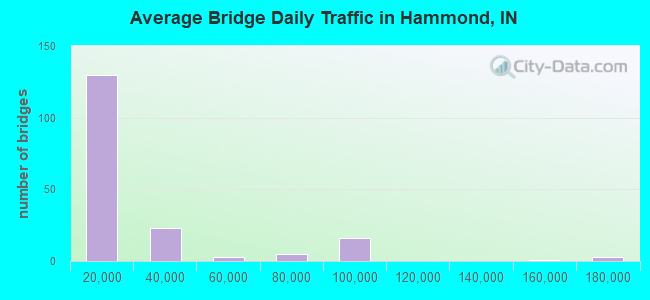
- 4,229,666Total average daily traffic
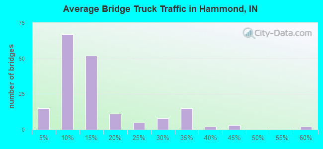
- 746,489Total average daily truck traffic
- National Bridge Inventory (NBI) Registered Bridges for Hammond
- No street view available for this location
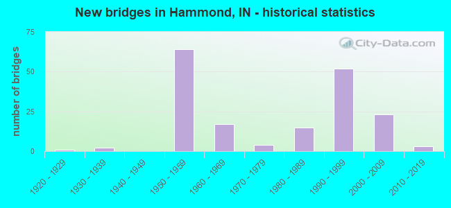
- New bridges - historical statistics
- 11920-1929
- 21930-1939
- 641950-1959
- 171960-1969
- 41970-1979
- 151980-1989
- 521990-1999
- 232000-2009
- 32010-2019
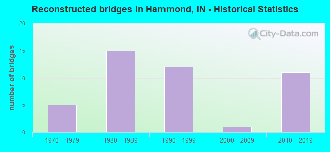
- Reconstructed bridges - Historical Statistics
- 51970-1979
- 151980-1989
- 121990-1999
- 12000-2009
- 112010-2019
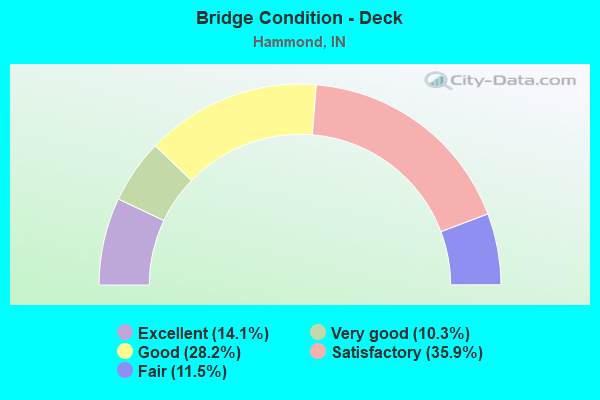
- Bridge Condition - Deck
- 14.1%Excellent
- 10.3%Very good
- 28.2%Good
- 35.9%Satisfactory
- 11.5%Fair
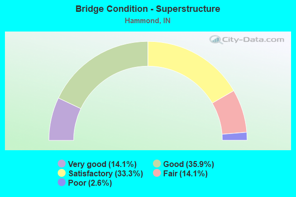
- Bridge Condition - Superstructure
- 14.1%Very good
- 35.9%Good
- 33.3%Satisfactory
- 14.1%Fair
- 2.6%Poor
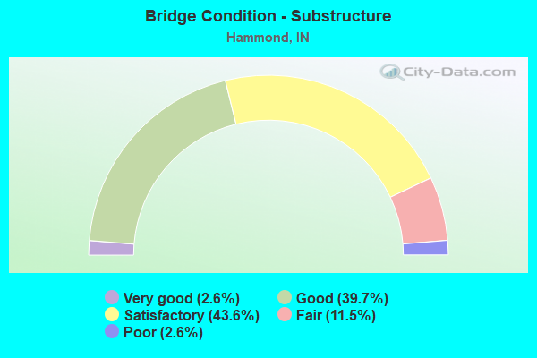
- Bridge Condition - Substructure
- 2.6%Very good
- 39.7%Good
- 43.6%Satisfactory
- 11.5%Fair
- 2.6%Poor
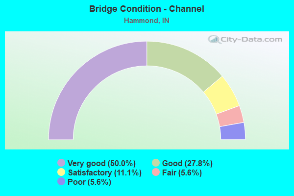
- Bridge Condition - Channel
- 50.0%Very good
- 27.8%Good
- 11.1%Satisfactory
- 5.6%Fair
- 5.6%Poor
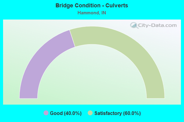
- Bridge Condition - Culverts
- 40.0%Good
- 60.0%Satisfactory
Find on map >> Show street view
Structure Number: 4500156, Location: 00.10 S MICHIGAN ST (Lat: 41.613150, Lng: -87.499969), Route carried "on" structure: City street , Year Built: 1963, Year Reconstructed: 2002, Status: Open, Structure Length: 29.38m (96.39ft), Average Daily Traffic: 17,931 (year 2012), Truck Traffic: 3%, Average Future Daily Traffic: 23,693 (year 2040), Design Load: HS 20, Features Intersected: CONRAIL RR, 3 STREETS, Facility Carried by Structure: COLUMBIA AVE
Minimum Vertical Clearance: 30+ m (98+ ft), Kilometerpoint: 0.000, Lanes on structure: 4, Lanes under structure: 6, Owner: County Highway Agency, Approaching Roadway Width: 17.1m (56.1ft), Skew: 23 degrees, Material/Design: Steel continuous, Design/Construction: Stringer/Multi-beam, Number Of Spans In Main Unit: 11, Length of Maximum Span: 30.5m (100.1ft), Curb or Sidewalk Widths: Left: 1.5m (4.9ft), Right: 0.0m, Curb-To-Curb Width: 17.1m (56.1ft), Out-to-Out Width: 19.3m (63.3ft)
Condition: Deck: Satisfactory, Superstructure: Good, Substructure: Satisfactory, Operating Rating: 43.7 metric tons, Method Used To Determine Operating Rating: Load Factor (LF), Inventory Rating: 26.2 metric tons, Method Used To Determine Inventory Rating: Load Factor (LF), Structural Evaluation: Equal to present minimum criteria, Deck Geometry: Somewhat better than minimum adequacy, Underclear: High priority of corrective action, Approach Roadway Alignment: Equal to present desirable criteria, Length Of Structure Improvement: 29.35m (96.29ft), Designated Inspection Frequency: Every 24 months, Inspection Date: August 2020, Bridge Improvement Cost: $1,928,000, Total Project Cost: $1,928,000 ( Estimate for 2020), Deck Structure Type: Concrete Cast-file-Place, Wearing Surface/Protective System: Wearing Surface: Monolithic Concrete, Deck Protection: Epoxy Coated Reinforcing
Find on map >> Show street view
Structure Number: 4500157, Location: 00.30 W. of KENNEDY AVE. (Lat: 41.588319, Lng: -87.466689), Route carried "on" structure: City street , Year Built: 1966, Year Reconstructed: 2005, Status: Open, Structure Length: 6.19m (20.31ft), Average Daily Traffic: 11,308 (year 2019), Truck Traffic: 4%, Average Future Daily Traffic: 13,936 (year 2040), Design Load: HS 20, Features Intersected: CONRAIL RAILROAD, Facility Carried by Structure: 169TH STREET
Minimum Vertical Clearance: 30+ m (98+ ft), Kilometerpoint: 0.000, Lanes on structure: 4, Owner: County Highway Agency, Approaching Roadway Width: 20.4m (66.9ft), Material/Design: Steel continuous, Design/Construction: Stringer/Multi-beam, Number Of Spans In Main Unit: 4, Length of Maximum Span: 16.8m (55.1ft), Curb or Sidewalk Widths: Left: 2.0m (6.6ft), Right: 2.0m (6.6ft), Curb-To-Curb Width: 20.4m (66.9ft), Out-to-Out Width: 25.0m (82.0ft)
Condition: Deck: Satisfactory, Superstructure: Good, Substructure: Good, Operating Rating: 85.9 metric tons, Method Used To Determine Operating Rating: Load Factor (LF), Inventory Rating: 51.4 metric tons, Method Used To Determine Inventory Rating: Load Factor (LF), Structural Evaluation: Better than present minimum criteria, Deck Geometry: Superior to present desirable criteria, Underclear: Somewhat better than minimum adequacy, Approach Roadway Alignment: Equal to present desirable criteria, Length Of Structure Improvement: 6.19m (20.31ft), Designated Inspection Frequency: Every 24 months, Inspection Date: August 2020, Bridge Improvement Cost: $415,000, Total Project Cost: $415,000 ( Estimate for 2020), Deck Structure Type: Concrete Cast-file-Place, Wearing Surface/Protective System: Wearing Surface: Monolithic Concrete
Find on map >> Show street view
Structure Number: 4500185, Location: 00.20 S. of US 20 (Lat: 41.605211, Lng: -87.461469), Route carried "on" structure: City street , Year Built: 1986, Status: Open, Structure Length: 11.34m (37.20ft), Average Daily Traffic: 8,530 (year 2019), Truck Traffic: 3%, Average Future Daily Traffic: 10,513 (year 2040), Design Load: HS 20, Features Intersected: CONRAIL/IHB RR, Facility Carried by Structure: KENNEDY AVENUE
Minimum Vertical Clearance: 30+ m (98+ ft), Kilometerpoint: 0.000, Lanes on structure: 4, Owner: County Highway Agency, Approaching Roadway Width: 14.6m (47.9ft), Skew: 9 degrees, Material/Design: Steel continuous, Design/Construction: Stringer/Multi-beam, Number Of Spans In Main Unit: 4, Length of Maximum Span: 30.8m (101.0ft), Curb-To-Curb Width: 19.5m (64.0ft), Out-to-Out Width: 20.5m (67.3ft)
Condition: Deck: Satisfactory, Superstructure: Good, Substructure: Fair, Operating Rating: 61.5 metric tons, Method Used To Determine Operating Rating: Load Factor (LF), Inventory Rating: 36.8 metric tons, Method Used To Determine Inventory Rating: Load Factor (LF), Structural Evaluation: Somewhat better than minimum adequacy, Deck Geometry: Better than present minimum criteria, Underclear: Somewhat better than minimum adequacy, Approach Roadway Alignment: Equal to present desirable criteria, Length Of Structure Improvement: 11.34m (37.20ft), Designated Inspection Frequency: Every 24 months, Inspection Date: August 2020, Bridge Improvement Cost: $250,000, Roadway Improvement Cost: $43,000, Total Project Cost: $293,000 ( Estimate for 2020), Deck Structure Type: Concrete Cast-file-Place, Wearing Surface/Protective System: Wearing Surface: Monolithic Concrete
Find on map >> Show street view
Structure Number: 450019, Location: 00.10 N SIBLEY BLVD (Lat: 41.621011, Lng: -87.520189), Route carried "on" structure: City street , Year Built: 1996, Status: Open, Structure Length: 11.43m (37.50ft), Average Daily Traffic: 18,753 (year 2012), Truck Traffic: 3%, Average Future Daily Traffic: 24,779 (year 2040), Design Load: HS 20, Features Intersected: CONRAIL RR, WILLOW CT, Facility Carried by Structure: HOHMAN AVENUE
Minimum Vertical Clearance: 30+ m (98+ ft), Kilometerpoint: 0.000, Lanes on structure: 4, Lanes under structure: 2, Owner: County Highway Agency, Approaching Roadway Width: 15.2m (49.9ft), Skew: 2 degrees, Material/Design: Steel continuous, Design/Construction: Stringer/Multi-beam, Number Of Spans In Main Unit: 3, Length of Maximum Span: 63.4m (208.0ft), Curb or Sidewalk Widths: Left: 1.7m (5.6ft), Right: 1.7m (5.6ft), Curb-To-Curb Width: 15.2m (49.9ft), Out-to-Out Width: 19.3m (63.3ft)
Condition: Deck: Satisfactory, Superstructure: Good, Substructure: Good, Operating Rating: 55.4 metric tons, Method Used To Determine Operating Rating: Load Factor (LF), Inventory Rating: 33.2 metric tons, Method Used To Determine Inventory Rating: Load Factor (LF), Structural Evaluation: Better than present minimum criteria, Deck Geometry: High priority of corrective action, Underclear: Meets minimum limits, Approach Roadway Alignment: Equal to present desirable criteria, Length Of Structure Improvement: 11.43m (37.50ft), Designated Inspection Frequency: Every 24 months, Inspection Date: August 2020, Bridge Improvement Cost: $894,000, Roadway Improvement Cost: $30,000, Total Project Cost: $924,000 ( Estimate for 2020), Deck Structure Type: Concrete Cast-file-Place, Wearing Surface/Protective System: Wearing Surface: Monolithic Concrete, Deck Protection: Epoxy Coated Reinforcing
Find on map >> Show street view
Structure Number: 4500197, Location: 00.10 N BRIDGE 367 (Lat: 41.695611, Lng: -87.514281), Route carried "on" structure: Ramp Other road , Year Built: 1996, Status: Posted for load, Structure Length: 24.26m (79.59ft), Average Daily Traffic: 6,533 (year 2021), Truck Traffic: 2%, Average Future Daily Traffic: 7,971 (year 2041), Design Load: HS 20, Features Intersected: RR, HAMMOND MARINA DR, Facility Carried by Structure: CASINO CENTER DR
Minimum Vertical Clearance: 30+ m (98+ ft), Kilometerpoint: 0.000, Lanes on structure: 2, Lanes under structure: 2, Owner: County Highway Agency, Approaching Roadway Width: 11.0m (36.1ft), Skew: 9 degrees, Material/Design: Prestressed concrete continuous, Design/Construction: Tee Beam, Number Of Spans In Main Unit: 8, Length of Maximum Span: 33.4m (109.6ft), Curb or Sidewalk Widths: Left: 0.0m, Right: 1.8m (5.9ft), Curb-To-Curb Width: 11.0m (36.1ft), Out-to-Out Width: 13.7m (44.9ft)
Condition: Deck: Satisfactory, Superstructure: Poor, Substructure: Satisfactory, Operating Rating: 33.2 metric tons, Method Used To Determine Operating Rating: Load Factor (LF), Inventory Rating: 19.9 metric tons, Method Used To Determine Inventory Rating: Load Factor (LF), Structural Evaluation: Meets minimum limits, Deck Geometry: Better than present minimum criteria, Underclear: High priority of corrective action, Approach Roadway Alignment: Equal to present minimum criteria, Length Of Structure Improvement: 24.26m (79.59ft), Designated Inspection Frequency: Every 12 months, Inspection Date: August 2021, Bridge Improvement Cost: $150,000, Roadway Improvement Cost: $10,000, Total Project Cost: $160,000 ( Estimate for 2021), Deck Structure Type: Concrete Cast-file-Place, Wearing Surface/Protective System: Wearing Surface: Monolithic Concrete, Deck Protection: Epoxy Coated Reinforcing
Find on map >> Show street view
Structure Number: 4500214, Location: 00.10 N. OF MICHIGAN ST. (Lat: 41.622569, Lng: -87.513289), Route carried "on" structure: City street , Year Built: 2009, Status: Open, Structure Length: 0.79m (2.59ft), Average Daily Traffic: 2,336 (year 2019), Truck Traffic: 3%, Average Future Daily Traffic: 2,879 (year 2040), Design Load: HS 20, Features Intersected: GRAND CALUMET RIVER, Facility Carried by Structure: SOHL AVENUE
Minimum Vertical Clearance: 30+ m (98+ ft), Kilometerpoint: 0.000, Lanes on structure: 2, Owner: County Highway Agency, Approaching Roadway Width: 12.2m (40.0ft), Skew: 1 degrees, Navigation Control: Yes ( Vertical Clearance: 1.8m (5.9ft), Horizontal Clearance: 1.8m (5.9ft)), Material/Design: Concrete, Design/Construction: Culvert, Number Of Spans In Main Unit: 3, Length of Maximum Span: 1.8m (5.9ft), Curb or Sidewalk Widths: Left: 0.0m, Right: 1.7m (5.6ft)
Condition: Channel: Fair, Culverts: Good, Operating Rating: 54.5 metric tons, Method Used To Determine Operating Rating: Field evaluation and documented engineering judgment, Inventory Rating: 32.7 metric tons, Method Used To Determine Inventory Rating: Field evaluation and documented engineering judgment, Structural Evaluation: Better than present minimum criteria, Waterway Adequacy: Superior to present desirable criteria, Approach Roadway Alignment: Equal to present desirable criteria, Designated Inspection Frequency: Every 24 months, Inspection Date: August 2020
Find on map >> Show street view
Structure Number: 3086, Location: 00.58 W US 41 (Lat: 41.694711, Lng: -87.515717), Route carried "under" structure: US 12, Year Built: 1996, Structure Length: 0. m, Average Daily Traffic: 7,160 (year 2004), Truck Traffic: 15%, Features Intersected: HAMMOND MARINA DR
Minimum Vertical Clearance: 5.64m (18.50ft), Kilometerpoint: 1.223, Lanes on structure: 2, Lanes under structure: 6, Material/Design: Prestressed concrete, Design/Construction: Tee Beam, Length of Maximum Span: 39.5m (129.6ft)
Find on map >> Show street view
Structure Number: 52, Location: 00.99 E SR-152 (Lat: 41.610019, Lng: -87.461647), Route carried "under" structure: City street , Year Built: 1934, Structure Length: 0. m, Average Daily Traffic: 16,541 (year 2004), Truck Traffic: 5%, Features Intersected: KENNEDY AVENUE, Facility Carried by Structure: US 20
Minimum Vertical Clearance: 6.71m (22.01ft), Kilometerpoint: 0.000, Lanes on structure: 2, Lanes under structure: 4, Material/Design: Prestressed concrete continuous, Design/Construction: Stringer/Multi-beam, Length of Maximum Span: 25.2m (82.7ft)
Find on map >> Show street view
Structure Number: 1568, Location: 03.78 S SR-312 (Lat: 41.574081, Lng: -87.509003), Route carried "under" structure: Interstate 80, Year Built: 1992, Structure Length: 0. m, Average Daily Traffic: 72,003 (year 2004), Truck Traffic: 25%, Features Intersected: I-80/94 EBL MAINLINE, Facility Carried by Structure: CALUMET AVE
Minimum Vertical Clearance: 5.31m (17.42ft), Kilometerpoint: 1.416, Lanes on structure: 5, Lanes under structure: 9, Material/Design: Steel continuous, Design/Construction: Box Beam or Girders - Single/Spread, Length of Maximum Span: 39.3m (128.9ft)
Find on map >> Show street view
Structure Number: 1568, Location: 03.78 S SR-312 (Lat: 41.574081, Lng: -87.509003), Route carried "under" structure: Interstate 80, Year Built: 1992, Structure Length: 0. m, Average Daily Traffic: 72,003 (year 2004), Truck Traffic: 25%, Features Intersected: I-80/94 WBL MAINLINE, Facility Carried by Structure: CALUMET AVE
Minimum Vertical Clearance: 5.31m (17.42ft), Kilometerpoint: 1.416, Lanes on structure: 5, Lanes under structure: 9, Material/Design: Steel continuous, Design/Construction: Box Beam or Girders - Single/Spread, Length of Maximum Span: 39.3m (128.9ft)
Find on map >> Show street view
Structure Number: 1568, Location: 03.78 S SR-312 (Lat: 41.574081, Lng: -87.509003), Route carried "under" structure: Ramp Interstate 80, Year Built: 1992, Structure Length: 0. m, Average Daily Traffic: 10,000 (year 2004), Truck Traffic: 25%, Features Intersected: I-80/94 EBL CD/RAMP, Facility Carried by Structure: CALUMET AVE
Minimum Vertical Clearance: 5.31m (17.42ft), Kilometerpoint: 1.416, Lanes on structure: 5, Lanes under structure: 9, Material/Design: Steel continuous, Design/Construction: Box Beam or Girders - Single/Spread, Length of Maximum Span: 39.3m (128.9ft)
Find on map >> Show street view
Structure Number: 1568, Location: 03.78 S SR-312 (Lat: 41.574081, Lng: -87.509003), Route carried "under" structure: Ramp Interstate 80, Year Built: 1992, Structure Length: 0. m, Average Daily Traffic: 10,000 (year 2004), Truck Traffic: 25%, Features Intersected: I-80/94 WBL CD/RAMP, Facility Carried by Structure: CALUMET AVE
Minimum Vertical Clearance: 5.31m (17.42ft), Kilometerpoint: 1.416, Lanes on structure: 5, Lanes under structure: 9, Material/Design: Steel continuous, Design/Construction: Box Beam or Girders - Single/Spread, Length of Maximum Span: 39.3m (128.9ft)
Find on map >> Show street view
Structure Number: 15684, Location: 00.10 W US 41 (Lat: 41.574081, Lng: -87.510903), Route carried "under" structure: Interstate 80, Year Built: 1992, Structure Length: 0. m, Average Daily Traffic: 72,003 (year 2004), Truck Traffic: 25%, Features Intersected: I-80/94 EB MAINLINE, Facility Carried by Structure: US 41 SB ON RAMP J
Minimum Vertical Clearance: 5.56m (18.24ft), Kilometerpoint: 1.255, Lanes on structure: 1, Lanes under structure: 14, Material/Design: Steel continuous, Design/Construction: Box Beam or Girders - Single/Spread, Length of Maximum Span: 43.7m (143.4ft)
Find on map >> Show street view
Structure Number: 15684, Location: 00.10 W US 41 (Lat: 41.574081, Lng: -87.510903), Route carried "under" structure: Interstate 80, Year Built: 1992, Structure Length: 0. m, Average Daily Traffic: 72,003 (year 2004), Truck Traffic: 25%, Features Intersected: I-80/94 WB MAINLINE, Facility Carried by Structure: US 41 SB ON RAMP J
Minimum Vertical Clearance: 5.56m (18.24ft), Kilometerpoint: 1.255, Lanes on structure: 1, Lanes under structure: 14, Material/Design: Steel continuous, Design/Construction: Box Beam or Girders - Single/Spread, Length of Maximum Span: 43.7m (143.4ft)
Find on map >> Show street view
Structure Number: 15684, Location: 00.10 W US 41 (Lat: 41.574081, Lng: -87.510903), Route carried "under" structure: City street , Year Built: 1992, Structure Length: 0. m, Average Daily Traffic: 20,000 (year 2004), Truck Traffic: 15%, Features Intersected: CALUMET AVE NB & RAMP, Facility Carried by Structure: US 41 SB ON RAMP J
Minimum Vertical Clearance: 5.56m (18.24ft), Kilometerpoint: 1.255, Lanes on structure: 1, Lanes under structure: 14, Material/Design: Steel continuous, Design/Construction: Box Beam or Girders - Single/Spread, Length of Maximum Span: 43.7m (143.4ft)
Find on map >> Show street view
Structure Number: 15684, Location: 00.10 W US 41 (Lat: 41.574081, Lng: -87.510903), Route carried "under" structure: City street , Year Built: 1992, Structure Length: 0. m, Average Daily Traffic: 20,000 (year 2004), Truck Traffic: 15%, Features Intersected: CALUMET AVE SB, RAMP, Facility Carried by Structure: US 41 SB ON RAMP J
Minimum Vertical Clearance: 5.56m (18.24ft), Kilometerpoint: 1.255, Lanes on structure: 1, Lanes under structure: 14, Material/Design: Steel continuous, Design/Construction: Box Beam or Girders - Single/Spread, Length of Maximum Span: 43.7m (143.4ft)
Find on map >> Show street view
Structure Number: 15684, Location: 00.10 W US 41 (Lat: 41.574081, Lng: -87.510903), Route carried "under" structure: Ramp Interstate 80, Year Built: 1992, Structure Length: 0. m, Average Daily Traffic: 10,000 (year 2004), Truck Traffic: 25%, Features Intersected: I-80/94 WB CD/RAMP, Facility Carried by Structure: US 41 SB ON RAMP J
Minimum Vertical Clearance: 5.56m (18.24ft), Kilometerpoint: 1.255, Lanes on structure: 1, Lanes under structure: 14, Material/Design: Steel continuous, Design/Construction: Box Beam or Girders - Single/Spread, Length of Maximum Span: 43.7m (143.4ft)
Find on map >> Show street view
Structure Number: 15684, Location: 00.10 W US 41 (Lat: 41.574081, Lng: -87.510903), Route carried "under" structure: Ramp Interstate 80, Year Built: 1992, Structure Length: 0. m, Average Daily Traffic: 10,000 (year 2004), Truck Traffic: 25%, Features Intersected: I-80/94 EB CD/RAMP, Facility Carried by Structure: US 41 SB ON RAMP J
Minimum Vertical Clearance: 5.56m (18.24ft), Kilometerpoint: 1.255, Lanes on structure: 1, Lanes under structure: 14, Material/Design: Steel continuous, Design/Construction: Box Beam or Girders - Single/Spread, Length of Maximum Span: 43.7m (143.4ft)
Find on map >> Show street view
Structure Number: 1569, Location: 02.94 N I-80 (Lat: 41.616839, Lng: -87.508903), Route carried "under" structure: City street , Year Built: 1974, Structure Length: 0. m, Average Daily Traffic: 100 (year 2004), Truck Traffic: 5%, Features Intersected: LOGAN STREET (ENDS), Facility Carried by Structure: US 41
Minimum Vertical Clearance: 4.34m (14.24ft), Kilometerpoint: 0.000, Lanes on structure: 4, Lanes under structure: 9, Material/Design: Steel continuous, Design/Construction: Stringer/Multi-beam, Length of Maximum Span: 30.5m (100.1ft)
Find on map >> Show street view
Structure Number: 1569, Location: 02.94 N I-80 (Lat: 41.616839, Lng: -87.508903), Route carried "under" structure: City street , Year Built: 1974, Structure Length: 0. m, Average Daily Traffic: 100 (year 2004), Truck Traffic: 5%, Features Intersected: INDIANA STREET (END), Facility Carried by Structure: US 41
Minimum Vertical Clearance: 4.34m (14.24ft), Kilometerpoint: 0.000, Lanes on structure: 4, Lanes under structure: 9, Material/Design: Steel continuous, Design/Construction: Stringer/Multi-beam, Length of Maximum Span: 30.5m (100.1ft)
Find on map >> Show street view
Structure Number: 1569, Location: 02.94 N I-80 (Lat: 41.616839, Lng: -87.508903), Route carried "under" structure: City street , Year Built: 1974, Structure Length: 0. m, Average Daily Traffic: 400 (year 2004), Truck Traffic: 5%, Features Intersected: WILLOW COURT, Facility Carried by Structure: US 41
Minimum Vertical Clearance: 4.34m (14.24ft), Kilometerpoint: 0.000, Lanes on structure: 4, Lanes under structure: 9, Material/Design: Steel continuous, Design/Construction: Stringer/Multi-beam, Length of Maximum Span: 30.5m (100.1ft)
Find on map >> Show street view
Structure Number: 1569, Location: 02.94 N I-80 (Lat: 41.616839, Lng: -87.508903), Route carried "under" structure: City street , Year Built: 1974, Structure Length: 0. m, Average Daily Traffic: 2,370 (year 2004), Truck Traffic: 5%, Features Intersected: STATE STREET, Facility Carried by Structure: US 41
Minimum Vertical Clearance: 4.34m (14.24ft), Kilometerpoint: 0.000, Lanes on structure: 4, Lanes under structure: 9, Material/Design: Steel continuous, Design/Construction: Stringer/Multi-beam, Length of Maximum Span: 30.5m (100.1ft)
Find on map >> Show street view
Structure Number: 33021, Location: 00.81 E I-90 (Lat: 41.656969, Lng: -87.508653), Route carried "under" structure: US 41, Year Built: 1984, Structure Length: 0. m, Average Daily Traffic: 425 (year 2011), Truck Traffic: 5%, Features Intersected: US 41/CALUMET AVE, Facility Carried by Structure: SR 912 EB
Minimum Vertical Clearance: 4.98m (16.34ft), Kilometerpoint: 56.633, Lanes on structure: 3, Lanes under structure: 5, Toll: On toll road, Material/Design: Prestressed concrete continuous, Design/Construction: Stringer/Multi-beam, Length of Maximum Span: 27.7m (90.9ft)
Find on map >> Show street view
Structure Number: 33022, Location: 00.81 E I-90 (Lat: 41.657111, Lng: -87.508644), Route carried "under" structure: US 41, Year Built: 1984, Structure Length: 0. m, Average Daily Traffic: 343 (year 2011), Truck Traffic: 13%, Features Intersected: US 41/CALUMET AVE, Facility Carried by Structure: SR 912 WB
Minimum Vertical Clearance: 5.03m (16.50ft), Kilometerpoint: 56.649, Lanes on structure: 3, Lanes under structure: 5, Toll: On toll road, Material/Design: Prestressed concrete continuous, Design/Construction: Stringer/Multi-beam, Length of Maximum Span: 27.7m (90.9ft)
Find on map >> Show street view
Structure Number: 331, Location: 01.27 E SR 312 (Lat: 41.610311, Lng: -87.432586), Route carried "under" structure: Interstate 90, Year Built: 1956, Structure Length: 0. m, Average Daily Traffic: 14,970 (year 2004), Truck Traffic: 20%, Features Intersected: US 12/SR 912
Minimum Vertical Clearance: 6.86m (22.51ft), Kilometerpoint: 15.305, Lanes on structure: 4, Lanes under structure: 2, Material/Design: Steel continuous, Design/Construction: Stringer/Multi-beam, Length of Maximum Span: 34.9m (114.5ft)
Find on map >> Show street view
Structure Number: 3311, Location: 00.47 E I-90 (Lat: 41.603639, Lng: -87.432586), Route carried "under" structure: US 12, Year Built: 1960, Structure Length: 0. m, Average Daily Traffic: 8,870 (year 2004), Truck Traffic: 10%, Features Intersected: US 12/20 EBL
Minimum Vertical Clearance: 4.83m (15.85ft), Kilometerpoint: 16.287, Lanes on structure: 6, Lanes under structure: 6, Material/Design: Steel continuous, Design/Construction: Stringer/Multi-beam, Length of Maximum Span: 16.5m (54.1ft)
Find on map >> Show street view
Structure Number: 3311, Location: 00.47 E I-90 (Lat: 41.603639, Lng: -87.432586), Route carried "under" structure: US 20, Year Built: 1960, Structure Length: 0. m, Average Daily Traffic: 8,870 (year 2004), Truck Traffic: 10%, Features Intersected: US 12/20 WBL, Facility Carried by Structure: US 12 EB/SR 912
Minimum Vertical Clearance: 4.83m (15.85ft), Kilometerpoint: 16.287, Lanes on structure: 6, Lanes under structure: 6, Material/Design: Steel continuous, Design/Construction: Stringer/Multi-beam, Length of Maximum Span: 16.5m (54.1ft)
Find on map >> Show street view
Structure Number: 3314, Location: 01.06 E US-20 (Lat: 41.588150, Lng: -87.432808), Route carried "under" structure: State highway 912, Year Built: 1966, Structure Length: 0. m, Average Daily Traffic: 44,400 (year 2004), Truck Traffic: 20%, Features Intersected: SR-912 WBL, Facility Carried by Structure: 169TH ST/15TH AVE
Minimum Vertical Clearance: 4.88m (16.01ft), Kilometerpoint: 14.742, Lanes on structure: 4, Lanes under structure: 4, Material/Design: Steel continuous, Design/Construction: Stringer/Multi-beam, Length of Maximum Span: 22.4m (73.5ft)
Find on map >> Show street view
Structure Number: 3314, Location: 01.06 E US-20 (Lat: 41.588150, Lng: -87.432808), Route carried "under" structure: State highway 912, Year Built: 1966, Structure Length: 0. m, Average Daily Traffic: 44,400 (year 2004), Truck Traffic: 20%, Features Intersected: SR-912 EBL, Facility Carried by Structure: 169TH ST/15TH AVE
Minimum Vertical Clearance: 4.88m (16.01ft), Kilometerpoint: 14.742, Lanes on structure: 4, Lanes under structure: 4, Material/Design: Steel continuous, Design/Construction: Stringer/Multi-beam, Length of Maximum Span: 22.4m (73.5ft)
Find on map >> Show street view
Structure Number: 3316, Location: 00.18 W I-80 (Lat: 41.573600, Lng: -87.432494), Route carried "under" structure: City street , Year Built: 1960, Structure Length: 0. m, Average Daily Traffic: 1,080 (year 2004), Truck Traffic: 5%, Features Intersected: 25TH AVE/177TH STST, Facility Carried by Structure: SR 912
Minimum Vertical Clearance: 5.82m (19.09ft), Kilometerpoint: 0.000, Lanes on structure: 4, Lanes under structure: 2, Material/Design: Steel continuous, Design/Construction: Stringer/Multi-beam, Length of Maximum Span: 16.8m (55.1ft)
Find on map >> Show street view
Structure Number: 33161, Location: 00.18 W I-80 (Lat: 41.573600, Lng: -87.433114), Route carried "under" structure: City street , Year Built: 1997, Structure Length: 0. m, Average Daily Traffic: 1,080 (year 2004), Truck Traffic: 5%, Features Intersected: SR 912 EB RMP TO I-80, Facility Carried by Structure: 25TH AVE/177TH ST
Minimum Vertical Clearance: 6.48m (21.26ft), Kilometerpoint: 0.000, Lanes on structure: 2, Lanes under structure: 2, Material/Design: Prestressed concrete continuous, Design/Construction: Stringer/Multi-beam, Length of Maximum Span: 17.7m (58.1ft)
Find on map >> Show street view
Structure Number: 4549, Location: 00.48 E US-41 (Lat: 41.574111, Lng: -87.499833), Route carried "under" structure: Interstate 80, Year Built: 1991, Structure Length: 0. m, Average Daily Traffic: 96,367 (year 2021), Truck Traffic: 30%, Features Intersected: I-80 (I-94) EBL, Facility Carried by Structure: COLUMBIA AVENUE
Minimum Vertical Clearance: 5.13m (16.83ft), Kilometerpoint: 2.173, Lanes on structure: 2, Lanes under structure: 10, Material/Design: Steel continuous, Design/Construction: Stringer/Multi-beam, Length of Maximum Span: 30.0m (98.4ft)
Find on map >> Show street view
Structure Number: 4549, Location: 00.48 E US-41 (Lat: 41.574111, Lng: -87.499833), Route carried "under" structure: Interstate 80, Year Built: 1991, Structure Length: 0. m, Average Daily Traffic: 93,614 (year 2021), Truck Traffic: 30%, Features Intersected: I-80 (I-94) WBL, Facility Carried by Structure: COLUMBIA AVENUE
Minimum Vertical Clearance: 5.13m (16.83ft), Kilometerpoint: 2.173, Lanes on structure: 2, Lanes under structure: 10, Material/Design: Steel continuous, Design/Construction: Stringer/Multi-beam, Length of Maximum Span: 30.0m (98.4ft)
Find on map >> Show street view
Structure Number: 4549, Location: 00.48 E US-41 (Lat: 41.574111, Lng: -87.499833), Route carried "under" structure: City street , Year Built: 1991, Structure Length: 0. m, Average Daily Traffic: 500 (year 2004), Truck Traffic: 5%, Features Intersected: 177TH STREET, Facility Carried by Structure: COLUMBIA AVENUE
Minimum Vertical Clearance: 5.13m (16.83ft), Kilometerpoint: 2.173, Lanes on structure: 2, Lanes under structure: 10, Material/Design: Steel continuous, Design/Construction: Stringer/Multi-beam, Length of Maximum Span: 30.0m (98.4ft)
Find on map >> Show street view
Structure Number: 45553, Location: 00.04 W US 41/SR 152 (Lat: 41.576181, Lng: -87.480889), Route carried "under" structure: State highway 152, Year Built: 1993, Structure Length: 0. m, Average Daily Traffic: 22,650 (year 2004), Truck Traffic: 15%, Features Intersected: SR 152 (INDY BLVD) SB, Facility Carried by Structure: I-80 RAMP 2I
Minimum Vertical Clearance: 5.03m (16.50ft), Kilometerpoint: 0.225, Lanes on structure: 1, Lanes under structure: 5, Material/Design: Steel continuous, Design/Construction: Box Beam or Girders - Single/Spread, Length of Maximum Span: 34.1m (111.9ft)
Find on map >> Show street view
Structure Number: 45553, Location: 00.04 W US 41/SR 152 (Lat: 41.576181, Lng: -87.480889), Route carried "under" structure: State highway 152, Year Built: 1993, Structure Length: 0. m, Average Daily Traffic: 22,650 (year 2004), Truck Traffic: 15%, Features Intersected: SR 152 (INDY BLVD) NB, Facility Carried by Structure: I-80 RAMP 2I
Minimum Vertical Clearance: 5.03m (16.50ft), Kilometerpoint: 0.225, Lanes on structure: 1, Lanes under structure: 5, Material/Design: Steel continuous, Design/Construction: Box Beam or Girders - Single/Spread, Length of Maximum Span: 34.1m (111.9ft)
Find on map >> Show street view
Structure Number: 45553, Location: 00.04 W US 41/SR 152 (Lat: 41.576181, Lng: -87.480889), Route carried "under" structure: Ramp State highway 152, Year Built: 1993, Structure Length: 0. m, Average Daily Traffic: 3,500 (year 2004), Truck Traffic: 15%, Features Intersected: SR 152 NB CD ON-RAMP, Facility Carried by Structure: I-80 RAMP 2I
Minimum Vertical Clearance: 5.03m (16.50ft), Kilometerpoint: 0.225, Lanes on structure: 1, Lanes under structure: 5, Material/Design: Steel continuous, Design/Construction: Box Beam or Girders - Single/Spread, Length of Maximum Span: 34.1m (111.9ft)
Find on map >> Show street view
Structure Number: 45555, Location: 00.15 S I-80/94 (Lat: 41.572539, Lng: -87.479461), Route carried "under" structure: Ramp US 80, Year Built: 1993, Structure Length: 0. m, Average Daily Traffic: 16,000 (year 2004), Truck Traffic: 10%, Features Intersected: I-80 EB RAMP
Minimum Vertical Clearance: 0.00m, Kilometerpoint: 44.756, Lanes on structure: 1, Lanes under structure: 1, Material/Design: Steel continuous, Design/Construction: Box Beam or Girders - Single/Spread, Length of Maximum Span: 36.3m (119.1ft)
Find on map >> Show street view
Structure Number: 45555, Location: 00.15 S I-80/94 (Lat: 41.572539, Lng: -87.479461), Route carried "under" structure: Ramp US 152, Year Built: 1993, Structure Length: 0. m, Average Daily Traffic: 20,000 (year 2004), Truck Traffic: 10%, Features Intersected: SR 152 NB
Minimum Vertical Clearance: 0.00m, Kilometerpoint: 44.756, Lanes on structure: 1, Lanes under structure: 2, Material/Design: Steel continuous, Design/Construction: Box Beam or Girders - Single/Spread, Length of Maximum Span: 36.3m (119.1ft)
Find on map >> Show street view
Structure Number: 45555, Location: 00.15 S I-80/94 (Lat: 41.572539, Lng: -87.479461), Route carried "under" structure: Ramp US 41, Year Built: 1993, Structure Length: 0. m, Average Daily Traffic: 20,000 (year 2004), Truck Traffic: 10%, Features Intersected: US 41 SB/CALUMET AVE, Facility Carried by Structure: SR 152 SB TO I-80
Minimum Vertical Clearance: 6.02m (19.75ft), Kilometerpoint: 44.756, Lanes on structure: 1, Lanes under structure: 2, Material/Design: Steel continuous, Design/Construction: Box Beam or Girders - Single/Spread, Length of Maximum Span: 36.3m (119.1ft)
Find on map >> Show street view
Structure Number: 45579, Location: 00.95 E US-41 (Lat: 41.574111, Lng: -87.463233), Route carried "under" structure: Interstate 80, Year Built: 1992, Structure Length: 0. m, Average Daily Traffic: 86,846 (year 2020), Truck Traffic: 2%, Features Intersected: I-80(I-94) WBL
Minimum Vertical Clearance: 5.56m (18.24ft), Kilometerpoint: 5.359, Lanes on structure: 1, Lanes under structure: 8, Material/Design: Steel continuous, Design/Construction: Box Beam or Girders - Single/Spread, Length of Maximum Span: 30.7m (100.7ft)
Find on map >> Show street view
Structure Number: 45579, Location: 00.95 E US-41 (Lat: 41.574111, Lng: -87.463233), Route carried "under" structure: Ramp Interstate 80, Year Built: 1992, Structure Length: 0. m, Average Daily Traffic: 3,500 (year 2004), Truck Traffic: 30%, Features Intersected: I-80(I-94) WBL-CD-RAMP
Minimum Vertical Clearance: 5.56m (18.24ft), Kilometerpoint: 5.359, Lanes on structure: 1, Lanes under structure: 8, Material/Design: Steel continuous, Design/Construction: Box Beam or Girders - Single/Spread, Length of Maximum Span: 30.7m (100.7ft)
Find on map >> Show street view
Structure Number: 45579, Location: 00.95 E US-41 (Lat: 41.574111, Lng: -87.463233), Route carried "under" structure: Ramp Interstate 80, Year Built: 1992, Structure Length: 0. m, Average Daily Traffic: 3,500 (year 2004), Truck Traffic: 30%, Features Intersected: I-80(I-94) EBL-CD-RAMP
Minimum Vertical Clearance: 5.56m (18.24ft), Kilometerpoint: 5.359, Lanes on structure: 1, Lanes under structure: 8, Material/Design: Steel continuous, Design/Construction: Box Beam or Girders - Single/Spread, Length of Maximum Span: 30.7m (100.7ft)
Find on map >> Show street view
Structure Number: 45579, Location: 00.95 E US-41 (Lat: 41.574111, Lng: -87.463233), Route carried "under" structure: Interstate 80, Year Built: 1992, Structure Length: 0. m, Average Daily Traffic: 86,846 (year 2020), Truck Traffic: 2%, Features Intersected: I-80(I-94) EBL
Minimum Vertical Clearance: 5.56m (18.24ft), Kilometerpoint: 5.359, Lanes on structure: 1, Lanes under structure: 8, Material/Design: Steel continuous, Design/Construction: Box Beam or Girders - Single/Spread, Length of Maximum Span: 30.7m (100.7ft)
Find on map >> Show street view
Structure Number: 4558, Location: 00.97 E US-41 (Lat: 41.574131, Lng: -87.461442), Route carried "under" structure: Ramp Interstate 80, Year Built: 1992, Structure Length: 0. m, Average Daily Traffic: 3,500 (year 2004), Truck Traffic: 30%, Features Intersected: I-80(I-94) EBL-CD-RAMP, Facility Carried by Structure: KENNEDY AVENUE
Minimum Vertical Clearance: 5.13m (16.83ft), Kilometerpoint: 5.391, Lanes on structure: 6, Lanes under structure: 8, Material/Design: Steel continuous, Design/Construction: Box Beam or Girders - Single/Spread, Length of Maximum Span: 30.3m (99.4ft)
Find on map >> Show street view
Structure Number: 4558, Location: 00.97 E US-41 (Lat: 41.574131, Lng: -87.461442), Route carried "under" structure: Ramp Interstate 80, Year Built: 1992, Structure Length: 0. m, Average Daily Traffic: 3,500 (year 2004), Truck Traffic: 30%, Features Intersected: I-80(I-94) WBL-CD-RAMP, Facility Carried by Structure: KENNEDY AVENUE
Minimum Vertical Clearance: 5.13m (16.83ft), Kilometerpoint: 5.391, Lanes on structure: 6, Lanes under structure: 8, Material/Design: Steel continuous, Design/Construction: Box Beam or Girders - Single/Spread, Length of Maximum Span: 30.3m (99.4ft)
Find on map >> Show street view
Structure Number: 4558, Location: 00.97 E US-41 (Lat: 41.574131, Lng: -87.461442), Route carried "under" structure: Interstate 80, Year Built: 1992, Structure Length: 0. m, Average Daily Traffic: 92,300 (year 2004), Truck Traffic: 30%, Features Intersected: I-80(I-94) WBL, Facility Carried by Structure: KENNEDY AVENUE
Minimum Vertical Clearance: 5.13m (16.83ft), Kilometerpoint: 5.391, Lanes on structure: 6, Lanes under structure: 8, Material/Design: Steel continuous, Design/Construction: Box Beam or Girders - Single/Spread, Length of Maximum Span: 30.3m (99.4ft)
Find on map >> Show street view
Structure Number: 4558, Location: 00.97 E US-41 (Lat: 41.574131, Lng: -87.461442), Route carried "under" structure: Interstate 80, Year Built: 1992, Structure Length: 0. m, Average Daily Traffic: 92,300 (year 2004), Truck Traffic: 30%, Features Intersected: I-80(I-94) EBL, Facility Carried by Structure: KENNEDY AVENUE
Minimum Vertical Clearance: 5.13m (16.83ft), Kilometerpoint: 5.391, Lanes on structure: 6, Lanes under structure: 8, Material/Design: Steel continuous, Design/Construction: Box Beam or Girders - Single/Spread, Length of Maximum Span: 30.3m (99.4ft)
Find on map >> Show street view
Structure Number: 45581, Location: 00.97 E US-41 (Lat: 41.575181, Lng: -87.460931), Route carried "under" structure: Ramp Interstate 80, Year Built: 1992, Structure Length: 0. m, Average Daily Traffic: 3,500 (year 2004), Truck Traffic: 10%, Features Intersected: I-80 RAMP F #1
Minimum Vertical Clearance: 5.26m (17.26ft), Kilometerpoint: 5.391, Lanes on structure: 1, Lanes under structure: 8, Material/Design: Steel continuous, Design/Construction: Box Beam or Girders - Single/Spread, Length of Maximum Span: 38.7m (127.0ft)
Find on map >> Show street view
Structure Number: 45581, Location: 00.97 E US-41 (Lat: 41.575181, Lng: -87.460931), Route carried "under" structure: City street , Year Built: 1992, Structure Length: 0. m, Average Daily Traffic: 32,900 (year 2004), Truck Traffic: 10%, Features Intersected: KENNEDY AVENUE SBL, Facility Carried by Structure: I-80 WB RAMP "I"
Minimum Vertical Clearance: 5.26m (17.26ft), Kilometerpoint: 5.391, Lanes on structure: 1, Lanes under structure: 8, Material/Design: Steel continuous, Design/Construction: Box Beam or Girders - Single/Spread, Length of Maximum Span: 38.7m (127.0ft)
Find on map >> Show street view
Structure Number: 45581, Location: 00.97 E US-41 (Lat: 41.575181, Lng: -87.460931), Route carried "under" structure: Ramp Interstate 80, Year Built: 1992, Structure Length: 0. m, Average Daily Traffic: 3,500 (year 2004), Truck Traffic: 10%, Features Intersected: I-80 RAMP F #2
Minimum Vertical Clearance: 5.26m (17.26ft), Kilometerpoint: 5.391, Lanes on structure: 1, Lanes under structure: 8, Material/Design: Steel continuous, Design/Construction: Box Beam or Girders - Single/Spread, Length of Maximum Span: 38.7m (127.0ft)
Find on map >> Show street view
Structure Number: 45581, Location: 00.97 E US-41 (Lat: 41.575181, Lng: -87.460931), Route carried "under" structure: City street , Year Built: 1992, Structure Length: 0. m, Average Daily Traffic: 32,900 (year 2004), Truck Traffic: 10%, Features Intersected: KENNEDY AVENUE NBL, Facility Carried by Structure: I-80 WB RAMP "I"
Minimum Vertical Clearance: 5.26m (17.26ft), Kilometerpoint: 5.391, Lanes on structure: 1, Lanes under structure: 8, Material/Design: Steel continuous, Design/Construction: Box Beam or Girders - Single/Spread, Length of Maximum Span: 38.7m (127.0ft)
Find on map >> Show street view
Structure Number: 45583, Location: 00.97 E US-41 (Lat: 41.572219, Lng: -87.461503), Route carried "under" structure: City street , Year Built: 1992, Structure Length: 0. m, Average Daily Traffic: 32,900 (year 2004), Truck Traffic: 10%, Features Intersected: KENNEDY AVE NBL & RAMP, Facility Carried by Structure: SB RAMP TO I-80/I-
Minimum Vertical Clearance: 4.98m (16.34ft), Kilometerpoint: 0.000, Lanes on structure: 1, Lanes under structure: 5, Material/Design: Steel continuous, Design/Construction: Box Beam or Girders - Single/Spread, Length of Maximum Span: 20.7m (67.9ft)
Find on map >> Show street view
Structure Number: 45583, Location: 00.97 E US-41 (Lat: 41.572219, Lng: -87.461503), Route carried "under" structure: City street , Year Built: 1992, Structure Length: 0. m, Average Daily Traffic: 32,900 (year 2004), Truck Traffic: 10%, Features Intersected: KENNEDY AVENUE SBL, Facility Carried by Structure: SB RAMP TO I-80/I-
Minimum Vertical Clearance: 4.98m (16.34ft), Kilometerpoint: 0.000, Lanes on structure: 1, Lanes under structure: 5, Material/Design: Steel continuous, Design/Construction: Box Beam or Girders - Single/Spread, Length of Maximum Span: 20.7m (67.9ft)
Find on map >> Show street view
Structure Number: 456, Location: 02.53 E US-41 (Lat: 41.570061, Lng: -87.432472), Route carried "under" structure: Ramp State highway 912, Year Built: 2001, Structure Length: 0. m, Average Daily Traffic: 4,000 (year 2020), Truck Traffic: 15%, Features Intersected: SR-912 EBL-CD-RAMP, Facility Carried by Structure: I-80 EB/WB
Minimum Vertical Clearance: 5.05m (16.57ft), Kilometerpoint: 16.753, Lanes on structure: 8, Lanes under structure: 9, Material/Design: Steel continuous, Design/Construction: Stringer/Multi-beam, Length of Maximum Span: 19.1m (62.7ft)
Find on map >> Show street view
Structure Number: 4585, Location: 04.10 W US 41 (Lat: 41.702981, Lng: -87.524461), Route carried "under" structure: US 12, Year Built: 1956, Structure Length: 0. m, Average Daily Traffic: 15,701 (year 2011), Truck Traffic: 8%, Features Intersected: US-12, US-20, & US-41, Facility Carried by Structure: I-90
Minimum Vertical Clearance: 4.93m (16.17ft), Kilometerpoint: 0.177, Lanes on structure: 4, Lanes under structure: 7, Toll: On toll road, Material/Design: Steel, Design/Construction: Stringer/Multi-beam, Length of Maximum Span: 18.9m (62.0ft)
Find on map >> Show street view
Structure Number: 4587, Location: 00.02 E US 12 (Lat: 41.701669, Lng: -87.523339), Route carried "under" structure: City street , Year Built: 1956, Structure Length: 0. m, Average Daily Traffic: 133 (year 2004), Truck Traffic: 5%, Features Intersected: 108th STREET, Facility Carried by Structure: I-90 ON RAMP
Minimum Vertical Clearance: 4.47m (14.67ft), Kilometerpoint: 0.000, Lanes on structure: 2, Lanes under structure: 2, Toll: On toll road, Material/Design: Steel, Design/Construction: Stringer/Multi-beam, Length of Maximum Span: 12.0m (39.4ft)
Find on map >> Show street view
Structure Number: 4588, Location: 00.26 E US 12 (Lat: 41.698661, Lng: -87.522156), Route carried "under" structure: Alternate City street , Year Built: 1956, Structure Length: 0. m, Average Daily Traffic: 133 (year 2004), Truck Traffic: 5%, Features Intersected: 108TH ST, Facility Carried by Structure: I-90 EB
Minimum Vertical Clearance: 4.40m (14.44ft), Kilometerpoint: 0.000, Lanes on structure: 2, Lanes under structure: 2, Material/Design: Steel, Design/Construction: Stringer/Multi-beam, Length of Maximum Span: 11.6m (38.1ft)
Find on map >> Show street view
Structure Number: 4589, Location: 00.26 E US 12 (Lat: 41.698631, Lng: -87.521889), Route carried "under" structure: Alternate City street , Year Built: 1956, Structure Length: 0. m, Average Daily Traffic: 133 (year 2004), Truck Traffic: 5%, Features Intersected: 108TH ST, Facility Carried by Structure: I-90 WB
Minimum Vertical Clearance: 4.93m (16.17ft), Kilometerpoint: 0.000, Lanes on structure: 2, Lanes under structure: 2, Material/Design: Steel, Design/Construction: Stringer/Multi-beam, Length of Maximum Span: 11.7m (38.4ft)
Find on map >> Show street view
Structure Number: 459, Location: 00.73 E US 12 (Lat: 41.691781, Lng: -87.522233), Route carried "under" structure: City street , Year Built: 1956, Structure Length: 0. m, Average Daily Traffic: 133 (year 2004), Truck Traffic: 5%, Features Intersected: 112TH ST, Facility Carried by Structure: I-90 EB
Minimum Vertical Clearance: 4.42m (14.50ft), Kilometerpoint: 0.000, Lanes on structure: 4, Lanes under structure: 2, Toll: On toll road, Material/Design: Steel, Design/Construction: Stringer/Multi-beam, Length of Maximum Span: 11.0m (36.1ft)
Find on map >> Show street view
Structure Number: 4591, Location: 00.73 E US 12 (Lat: 41.691800, Lng: -87.521828), Route carried "under" structure: County highway , Year Built: 1956, Structure Length: 0. m, Average Daily Traffic: 133 (year 2004), Truck Traffic: 5%, Features Intersected: 112TH ST, Facility Carried by Structure: I-90 WB
Minimum Vertical Clearance: 4.37m (14.34ft), Kilometerpoint: 0.000, Lanes on structure: 4, Lanes under structure: 2, Toll: On toll road, Material/Design: Steel, Design/Construction: Stringer/Multi-beam, Length of Maximum Span: 11.0m (36.1ft)
Find on map >> Show street view
Structure Number: 4596, Location: 01.21 W US 41 (Lat: 41.660969, Lng: -87.517669), Route carried "under" structure: ServiceOther road , Year Built: 1956, Structure Length: 0. m, Average Daily Traffic: 133 (year 2004), Truck Traffic: 5%, Features Intersected: 129TH ST, Facility Carried by Structure: I-90 EB
Minimum Vertical Clearance: 5.33m (17.49ft), Kilometerpoint: 0.000, Lanes on structure: 4, Lanes under structure: 2, Toll: On toll road, Material/Design: Steel, Design/Construction: Stringer/Multi-beam, Length of Maximum Span: 20.1m (65.9ft)
Find on map >> Show street view
Structure Number: 4597, Location: 01.21 W US 41 (Lat: 41.660950, Lng: -87.517264), Route carried "under" structure: ServiceOther road , Year Built: 1956, Structure Length: 0. m, Average Daily Traffic: 133 (year 2004), Truck Traffic: 5%, Features Intersected: 129TH ST, Facility Carried by Structure: I-90 WB
Minimum Vertical Clearance: 5.51m (18.08ft), Kilometerpoint: 0.000, Lanes on structure: 4, Lanes under structure: 2, Toll: On toll road, Material/Design: Steel, Design/Construction: Stringer/Multi-beam, Length of Maximum Span: 20.1m (65.9ft)
Find on map >> Show street view
Structure Number: 45975, Location: 00.26 W US 41 (Lat: 41.657039, Lng: -87.513458), Route carried "under" structure: City street , Year Built: 1984, Structure Length: 0. m, Average Daily Traffic: 11,426 (year 2014), Truck Traffic: 5%, Features Intersected: SHEFFIELD AVENUE, Facility Carried by Structure: 912WB RAMP TO I-90
Minimum Vertical Clearance: 6.04m (19.82ft), Kilometerpoint: 0.000, Lanes on structure: 2, Lanes under structure: 4, Material/Design: Steel, Design/Construction: Stringer/Multi-beam, Length of Maximum Span: 24.4m (80.1ft)
Find on map >> Show street view
Structure Number: 45977, Location: 00.83 W US 41 (Lat: 41.656289, Lng: -87.515039), Route carried "under" structure: Interstate 90, Year Built: 1984, Structure Length: 0. m, Average Daily Traffic: 34,900 (year 2015), Truck Traffic: 11%, Features Intersected: I-90 EB RAMP TO 912 EB
Minimum Vertical Clearance: 5.08m (16.67ft), Kilometerpoint: 5.375, Lanes on structure: 2, Lanes under structure: 8, Toll: On toll road, Material/Design: Steel, Design/Construction: Stringer/Multi-beam, Length of Maximum Span: 32.0m (105.0ft)
Find on map >> Show street view
Structure Number: 45977, Location: 00.83 W US 41 (Lat: 41.656289, Lng: -87.515039), Route carried "under" structure: City street , Year Built: 1984, Structure Length: 0. m, Average Daily Traffic: 11,426 (year 2014), Truck Traffic: 5%, Features Intersected: SHEFFIELD AVENUE, Facility Carried by Structure: I-90 EB RAMP TO 91
Minimum Vertical Clearance: 5.08m (16.67ft), Kilometerpoint: 5.375, Lanes on structure: 2, Lanes under structure: 8, Material/Design: Steel, Design/Construction: Stringer/Multi-beam, Length of Maximum Span: 32.0m (105.0ft)
Find on map >> Show street view
Structure Number: 46, Location: 00.66 W US 41 (Lat: 41.653089, Lng: -87.514825), Route carried "under" structure: City street , Year Built: 1956, Structure Length: 0. m, Average Daily Traffic: 11,426 (year 2014), Truck Traffic: 5%, Features Intersected: SHEFFIELD AVE, Facility Carried by Structure: I-90 EB
Minimum Vertical Clearance: 4.66m (15.29ft), Kilometerpoint: 0.000, Lanes on structure: 2, Lanes under structure: 4, Material/Design: Steel, Design/Construction: Stringer/Multi-beam, Length of Maximum Span: 36.0m (118.1ft)
Find on map >> Show street view
Structure Number: 4601, Location: 00.66 W US 41 (Lat: 41.653511, Lng: -87.514672), Route carried "under" structure: City street , Year Built: 1956, Structure Length: 0. m, Average Daily Traffic: 11,677 (year 2015), Truck Traffic: 5%, Features Intersected: SHEFFIELD AVE, Facility Carried by Structure: I-90 WB
Minimum Vertical Clearance: 4.66m (15.29ft), Kilometerpoint: 0.000, Lanes on structure: 2, Lanes under structure: 4, Material/Design: Steel, Design/Construction: Stringer/Multi-beam, Length of Maximum Span: 36.0m (118.1ft)
Find on map >> Show street view
Structure Number: 4602, Location: 01.31 W SR 312 (Lat: 41.644789, Lng: -87.508719), Route carried "under" structure: US 41, Year Built: 1956, Structure Length: 0. m, Average Daily Traffic: 21,597 (year 2014), Truck Traffic: 8%, Features Intersected: US 41/CALUMET AVE, Facility Carried by Structure: I-90 EB
Minimum Vertical Clearance: 4.33m (14.21ft), Kilometerpoint: 55.297, Lanes on structure: 2, Lanes under structure: 4, Toll: On toll road, Material/Design: Steel, Design/Construction: Stringer/Multi-beam, Length of Maximum Span: 44.2m (145.0ft)
Find on map >> Show street view
Structure Number: 4603, Location: 01.31 W SR 312 (Lat: 41.645150, Lng: -87.508714), Route carried "under" structure: US 41, Year Built: 1956, Structure Length: 0. m, Average Daily Traffic: 21,597 (year 2014), Truck Traffic: 5%, Features Intersected: US 41/CALUMET AVE, Facility Carried by Structure: I-90 WB
Minimum Vertical Clearance: 4.33m (14.21ft), Kilometerpoint: 55.313, Lanes on structure: 2, Lanes under structure: 4, Toll: On toll road, Material/Design: Steel, Design/Construction: Stringer/Multi-beam, Length of Maximum Span: 44.2m (145.0ft)
Find on map >> Show street view
Structure Number: 4604, Location: 00.42 E US 41 (Lat: 41.639350, Lng: -87.506194), Route carried "under" structure: Interstate 90, Year Built: 1956, Structure Length: 0. m, Average Daily Traffic: 18,425 (year 2015), Truck Traffic: 11%, Features Intersected: I-90 EB, Facility Carried by Structure: 141ST STREET
Minimum Vertical Clearance: 4.90m (16.08ft), Kilometerpoint: 7.403, Lanes on structure: 2, Lanes under structure: 2, Toll: On toll road, Material/Design: Steel, Design/Construction: Stringer/Multi-beam, Length of Maximum Span: 20.1m (65.9ft)
Find on map >> Show street view
Structure Number: 4604, Location: 00.42 E US 41 (Lat: 41.639350, Lng: -87.506194), Route carried "under" structure: Interstate 90, Year Built: 1956, Structure Length: 0. m, Average Daily Traffic: 18,425 (year 2015), Truck Traffic: 11%, Features Intersected: I-90 WB, Facility Carried by Structure: 141ST STREET
Minimum Vertical Clearance: 4.90m (16.08ft), Kilometerpoint: 7.403, Lanes on structure: 2, Lanes under structure: 2, Toll: On toll road, Material/Design: Steel, Design/Construction: Stringer/Multi-beam, Length of Maximum Span: 20.1m (65.9ft)
Find on map >> Show street view
Structure Number: 4604, Location: 00.42 E US 41 (Lat: 41.639350, Lng: -87.506194), Route carried "under" structure: Ramp Interstate 90, Year Built: 1956, Structure Length: 0. m, Average Daily Traffic: 2,300 (year 2015), Truck Traffic: 19%, Features Intersected: I-90 WB TO 141ST ST, Facility Carried by Structure: 141ST STREET
Minimum Vertical Clearance: 4.90m (16.08ft), Kilometerpoint: 7.403, Lanes on structure: 2, Lanes under structure: 2, Toll: On toll road, Material/Design: Steel, Design/Construction: Stringer/Multi-beam, Length of Maximum Span: 20.1m (65.9ft)
Find on map >> Show street view
Structure Number: 4605, Location: 00.50 W SR 312 (Lat: 41.633850, Lng: -87.505181), Route carried "under" structure: City street , Year Built: 1956, Structure Length: 0. m, Average Daily Traffic: 133 (year 2004), Truck Traffic: 5%, Features Intersected: HUEHN ST, Facility Carried by Structure: I-90 EB
Minimum Vertical Clearance: 4.62m (15.16ft), Kilometerpoint: 0.000, Lanes on structure: 2, Lanes under structure: 2, Toll: On toll road, Material/Design: Steel, Design/Construction: Stringer/Multi-beam, Length of Maximum Span: 18.3m (60.0ft)
Find on map >> Show street view
Structure Number: 4606, Location: 00.50 W SR 312 (Lat: 41.633850, Lng: -87.504944), Route carried "under" structure: City street , Year Built: 1956, Structure Length: 0. m, Average Daily Traffic: 133 (year 2004), Truck Traffic: 5%, Features Intersected: HUEHN ST, Facility Carried by Structure: I-90 WB
Minimum Vertical Clearance: 4.62m (15.16ft), Kilometerpoint: 0.000, Lanes on structure: 2, Lanes under structure: 2, Toll: On toll road, Material/Design: Steel, Design/Construction: Stringer/Multi-beam, Length of Maximum Span: 18.3m (60.0ft)
Find on map >> Show street view
Structure Number: 4607, Location: 00.34 W SR 312 (Lat: 41.632089, Lng: -87.503150), Route carried "under" structure: City street , Year Built: 1956, Structure Length: 0. m, Average Daily Traffic: 5,697 (year 2014), Truck Traffic: 6%, Features Intersected: GOSTLIN ST, Facility Carried by Structure: I-90 EB
Minimum Vertical Clearance: 5.44m (17.85ft), Kilometerpoint: 0.000, Lanes on structure: 2, Lanes under structure: 2, Toll: On toll road, Material/Design: Steel, Design/Construction: Stringer/Multi-beam, Length of Maximum Span: 26.2m (86.0ft)
Find on map >> Show street view
Structure Number: 4608, Location: 00.34 W SR 312 (Lat: 41.632089, Lng: -87.502883), Route carried "under" structure: City street , Year Built: 1956, Structure Length: 0. m, Average Daily Traffic: 5,697 (year 2014), Truck Traffic: 6%, Features Intersected: GOSTLIN ST, Facility Carried by Structure: I-90 WB
Minimum Vertical Clearance: 5.44m (17.85ft), Kilometerpoint: 0.000, Lanes on structure: 2, Lanes under structure: 2, Toll: On toll road, Material/Design: Steel, Design/Construction: Stringer/Multi-beam, Length of Maximum Span: 26.2m (86.0ft)
Find on map >> Show street view
Structure Number: 4609, Location: 00.14 W SR 312 (Lat: 41.630281, Lng: -87.500092), Route carried "under" structure: City street , Year Built: 1956, Structure Length: 0. m, Average Daily Traffic: 133 (year 2004), Truck Traffic: 5%, Features Intersected: COLUMBIA AVE, Facility Carried by Structure: I-90 EB
Minimum Vertical Clearance: 6.27m (20.57ft), Kilometerpoint: 0.000, Lanes on structure: 2, Lanes under structure: 4, Material/Design: Steel, Design/Construction: Stringer/Multi-beam, Length of Maximum Span: 30.8m (101.0ft)
Find on map >> Show street view
Structure Number: 461, Location: 00.14 W SR 312 (Lat: 41.630450, Lng: -87.500100), Route carried "under" structure: City street , Year Built: 1956, Structure Length: 0. m, Average Daily Traffic: 133 (year 2004), Truck Traffic: 5%, Features Intersected: COLUMBIA AVE, Facility Carried by Structure: I-90 WB
Minimum Vertical Clearance: 6.27m (20.57ft), Kilometerpoint: 0.000, Lanes on structure: 2, Lanes under structure: 4, Toll: On toll road, Material/Design: Steel, Design/Construction: Stringer/Multi-beam, Length of Maximum Span: 30.8m (101.0ft)