Bridge Statistics for Hammonton, New Jersey (NJ)
Condition, Traffic, Stress, Structural Evaluation, Project Costs
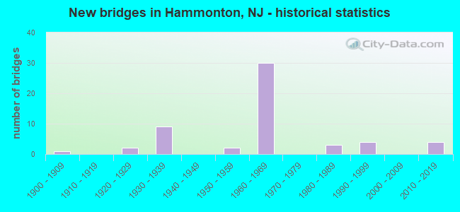
- New bridges - historical statistics
- 11900-1909
- 21920-1929
- 91930-1939
- 21950-1959
- 301960-1969
- 31980-1989
- 41990-1999
- 42010-2019
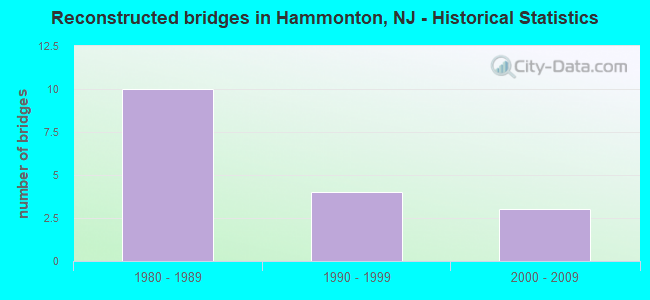
- Reconstructed bridges - Historical Statistics
- 101980-1989
- 41990-1999
- 32000-2009
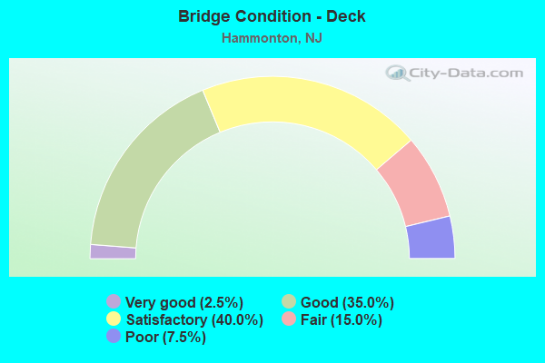
- Bridge Condition - Deck
- 2.5%Very good
- 35.0%Good
- 40.0%Satisfactory
- 15.0%Fair
- 7.5%Poor
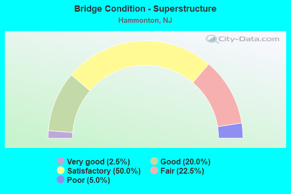
- Bridge Condition - Superstructure
- 2.5%Very good
- 20.0%Good
- 50.0%Satisfactory
- 22.5%Fair
- 5.0%Poor
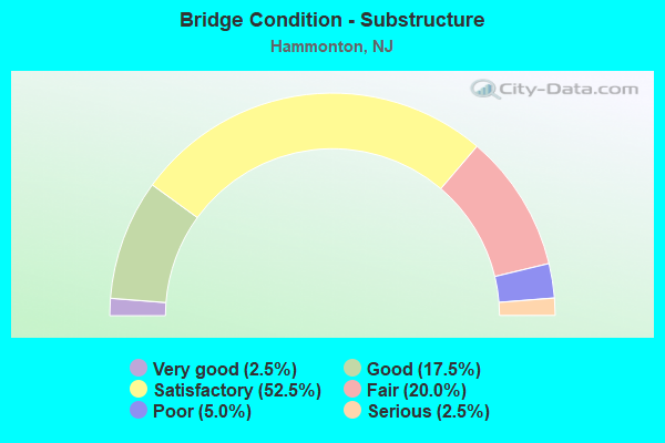
- Bridge Condition - Substructure
- 2.5%Very good
- 17.5%Good
- 52.5%Satisfactory
- 20.0%Fair
- 5.0%Poor
- 2.5%Serious
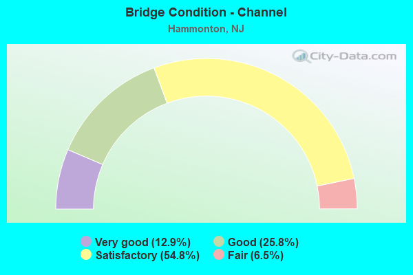
- Bridge Condition - Channel
- 12.9%Very good
- 25.8%Good
- 54.8%Satisfactory
- 6.5%Fair
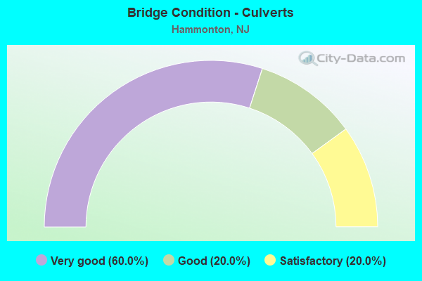
- Bridge Condition - Culverts
- 60.0%Very good
- 20.0%Good
- 20.0%Satisfactory
Find on map >> Show street view
Structure Number: 350294, Location: 1.6 MILES WEST OF RT 54 (Lat: 39.630000, Lng: -74.855000), Route carried "on" structure: Other road ACE, Year Built: 1963, Status: Open, Structure Length: 0.70m (2.30ft), Average Daily Traffic: 48,750 (year 2006), Truck Traffic: 5%, Average Future Daily Traffic: 67,930 (year 2026), Design Load: HS 20, Features Intersected: DRAINAGE DITCH, Facility Carried by Structure: A.C. EXPRESSWAY
Minimum Vertical Clearance: 30+ m (98+ ft), Kilometerpoint: 47.315, Lanes on structure: 6, Base Highway Network: Yes, Toll: On toll road, Owner: State Toll Authority, Maintenance Responsibility: Private, Approaching Roadway Width: 27.7m (90.9ft), Skew: 30 degrees, Material/Design: Concrete, Design/Construction: Culvert, Number Of Spans In Main Unit: 2, Length of Maximum Span: 3.0m (9.8ft)
Condition: Channel: Good, Culverts: Good, Operating Rating: 45.4 metric tons, Method Used To Determine Operating Rating: Load Factor (LF), Inventory Rating: 32.7 metric tons, Method Used To Determine Inventory Rating: Load Factor (LF), Structural Evaluation: Better than present minimum criteria, Waterway Adequacy: Superior to present desirable criteria, Approach Roadway Alignment: Equal to present desirable criteria, Designated Inspection Frequency: Every 24 months, Inspection Date: March 2020, Wearing Surface/Protective System: Wearing Surface: Bituminous
Find on map >> Show street view
Structure Number: 350301, Location: 1.3 MI E. OF INTRCHNG. 31 (Lat: 39.636669, Lng: -74.860000), Route carried "on" structure: Other road ACE, Year Built: 1963, Status: Open, Structure Length: 3.57m (11.71ft), Average Daily Traffic: 55,404 (year 2012), Truck Traffic: 7%, Average Future Daily Traffic: 77,065 (year 2032), Design Load: HS 20, Features Intersected: PENNY POT STREAM, Facility Carried by Structure: A.C. EXPRESSWAY
Minimum Vertical Clearance: 30+ m (98+ ft), Kilometerpoint: 48.441, Lanes on structure: 5, Base Highway Network: Yes, Toll: On toll road, Owner: State Toll Authority, Maintenance Responsibility: Private, Approaching Roadway Width: 29.3m (96.1ft), Skew: 30 degrees, Material/Design: Concrete, Design/Construction: Culvert, Number Of Spans In Main Unit: 1, Length of Maximum Span: 7.6m (24.9ft), Curb or Sidewalk Widths: Left: 0.5m (1.6ft), Right: 0.5m (1.6ft), Curb-To-Curb Width: 33.5m (109.9ft), Out-to-Out Width: 35.7m (117.1ft)
Condition: Channel: Good, Culverts: Satisfactory, Operating Rating: 62.6 metric tons, Method Used To Determine Operating Rating: Load Factor (LF), Inventory Rating: 37.2 metric tons, Method Used To Determine Inventory Rating: Load Factor (LF), Structural Evaluation: Equal to present minimum criteria, Deck Geometry: Superior to present desirable criteria, Waterway Adequacy: Equal to present desirable criteria, Approach Roadway Alignment: Better than present minimum criteria, Designated Inspection Frequency: Every 24 months, Inspection Date: March 2020, Wearing Surface/Protective System: Wearing Surface: Bituminous
Find on map >> Show street view
Structure Number: 350309N, Location: 2.1 MI E INTERCHANGE 33 (Lat: 39.646669, Lng: -74.870000), Route carried "on" structure: Other road ACE, Year Built: 1963, Year Reconstructed: 1987, Status: Open, Structure Length: 6.10m (20.01ft), Average Daily Traffic: 23,930 (year 2006), Truck Traffic: 7%, Average Future Daily Traffic: 33,300 (year 2026), Design Load: HS 20+Mod, Features Intersected: Albertson Road
Minimum Vertical Clearance: 30+ m (98+ ft), Kilometerpoint: 49.729, Lanes on structure: 3, Lanes under structure: 2, Base Highway Network: Yes, Toll: On toll road, Owner: State Toll Authority, Maintenance Responsibility: Private, Approaching Roadway Width: 12.5m (41.0ft), Skew: 3 degrees, Material/Design: Steel, Design/Construction: Stringer/Multi-beam, Number Of Spans In Main Unit: 4, Length of Maximum Span: 21.6m (70.9ft), Curb or Sidewalk Widths: Left: 0.0m, Right: 0.5m (1.6ft), Curb-To-Curb Width: 14.6m (47.9ft), Out-to-Out Width: 15.9m (52.2ft)
Condition: Deck: Good, Superstructure: Fair, Substructure: Satisfactory, Operating Rating: 58.1 metric tons, Method Used To Determine Operating Rating: Load Factor (LF), Inventory Rating: 34.5 metric tons, Method Used To Determine Inventory Rating: Load Factor (LF), Structural Evaluation: Somewhat better than minimum adequacy, Deck Geometry: Somewhat better than minimum adequacy, Underclear: Somewhat better than minimum adequacy, Approach Roadway Alignment: Better than present minimum criteria, Designated Inspection Frequency: Every 24 months, Inspection Date: Febuary 2020, Deck Structure Type: Concrete Cast-file-Place, Wearing Surface/Protective System: Wearing Surface: Bituminous
Find on map >> Show street view
Structure Number: 350309S, Location: 2.1 MI E INTERCHANGE 33 (Lat: 39.646669, Lng: -74.870000), Route carried "on" structure: Other road ACE, Year Built: 1963, Year Reconstructed: 1987, Status: Open, Structure Length: 6.10m (20.01ft), Average Daily Traffic: 23,930 (year 2006), Truck Traffic: 7%, Average Future Daily Traffic: 33,300 (year 2026), Design Load: HS 20+Mod, Features Intersected: ALBERTSON ROAD & CEN RR
Minimum Vertical Clearance: 30+ m (98+ ft), Kilometerpoint: 49.729, Lanes on structure: 3, Lanes under structure: 2, Base Highway Network: Yes, Toll: On toll road, Owner: State Toll Authority, Maintenance Responsibility: Private, Approaching Roadway Width: 16.2m (53.1ft), Skew: 10 degrees, Material/Design: Steel, Design/Construction: Stringer/Multi-beam, Number Of Spans In Main Unit: 4, Length of Maximum Span: 21.6m (70.9ft), Curb or Sidewalk Widths: Left: 0.0m, Right: 0.5m (1.6ft), Curb-To-Curb Width: 14.9m (48.9ft), Out-to-Out Width: 16.2m (53.1ft)
Condition: Deck: Good, Superstructure: Fair, Substructure: Satisfactory, Operating Rating: 58.1 metric tons, Method Used To Determine Operating Rating: Load Factor (LF), Inventory Rating: 34.5 metric tons, Method Used To Determine Inventory Rating: Load Factor (LF), Structural Evaluation: Somewhat better than minimum adequacy, Deck Geometry: Equal to present minimum criteria, Underclear: Somewhat better than minimum adequacy, Approach Roadway Alignment: Better than present minimum criteria, Designated Inspection Frequency: Every 24 months, Inspection Date: Febuary 2020, Deck Structure Type: Concrete Cast-file-Place, Wearing Surface/Protective System: Wearing Surface: Bituminous
Find on map >> Show street view
Structure Number: 350312N, Location: AT RT73&ACE JUNCTION (Lat: 39.648331, Lng: -74.870000), Route carried "on" structure: Other road ACE, Year Built: 1963, Year Reconstructed: 1987, Status: Open, Structure Length: 4.11m (13.48ft), Average Daily Traffic: 37,300 (year 2006), Truck Traffic: 7%, Average Future Daily Traffic: 51,000 (year 2026), Design Load: HS 20+Mod, Features Intersected: FOLSOM ROAD
Minimum Vertical Clearance: 30+ m (98+ ft), Kilometerpoint: 50.533, Lanes on structure: 3, Lanes under structure: 3, Base Highway Network: Yes, Toll: On toll road, Owner: State Toll Authority, Maintenance Responsibility: Private, Approaching Roadway Width: 16.2m (53.1ft), Skew: 3 degrees, Material/Design: Steel, Design/Construction: Stringer/Multi-beam, Number Of Spans In Main Unit: 3, Length of Maximum Span: 23.2m (76.1ft), Curb or Sidewalk Widths: Left: 0.0m, Right: 0.5m (1.6ft), Curb-To-Curb Width: 14.9m (48.9ft), Out-to-Out Width: 16.2m (53.1ft)
Condition: Deck: Satisfactory, Superstructure: Fair, Substructure: Satisfactory, Operating Rating: 64.4 metric tons, Method Used To Determine Operating Rating: Load Factor (LF), Inventory Rating: 39.0 metric tons, Method Used To Determine Inventory Rating: Load Factor (LF), Structural Evaluation: Somewhat better than minimum adequacy, Deck Geometry: Meets minimum limits, Underclear: Somewhat better than minimum adequacy, Approach Roadway Alignment: Better than present minimum criteria, Designated Inspection Frequency: Every 24 months, Inspection Date: Febuary 2020, Deck Structure Type: Concrete Cast-file-Place, Wearing Surface/Protective System: Wearing Surface: Bituminous
Find on map >> Show street view
Structure Number: 350312S, Location: AT RT73&ACE JUNCTION (Lat: 39.648331, Lng: -74.870000), Route carried "on" structure: Other road ACE, Year Built: 1963, Year Reconstructed: 1987, Status: Open, Structure Length: 4.11m (13.48ft), Average Daily Traffic: 35,700 (year 2006), Truck Traffic: 7%, Average Future Daily Traffic: 50,000 (year 2026), Design Load: HS 20+Mod, Features Intersected: FOLSOM ROAD
Minimum Vertical Clearance: 30+ m (98+ ft), Kilometerpoint: 50.533, Lanes on structure: 3, Lanes under structure: 3, Base Highway Network: Yes, Toll: On toll road, Owner: State Toll Authority, Maintenance Responsibility: Private, Approaching Roadway Width: 16.5m (54.1ft), Skew: 3 degrees, Material/Design: Steel, Design/Construction: Stringer/Multi-beam, Number Of Spans In Main Unit: 3, Length of Maximum Span: 23.2m (76.1ft), Curb or Sidewalk Widths: Left: 0.0m, Right: 0.5m (1.6ft), Curb-To-Curb Width: 14.9m (48.9ft), Out-to-Out Width: 16.2m (53.1ft)
Condition: Deck: Satisfactory, Superstructure: Fair, Substructure: Satisfactory, Operating Rating: 64.4 metric tons, Method Used To Determine Operating Rating: Load Factor (LF), Inventory Rating: 39.0 metric tons, Method Used To Determine Inventory Rating: Load Factor (LF), Structural Evaluation: Somewhat better than minimum adequacy, Deck Geometry: Meets minimum limits, Underclear: Somewhat better than minimum adequacy, Approach Roadway Alignment: Equal to present desirable criteria, Designated Inspection Frequency: Every 24 months, Inspection Date: Febuary 2020, Deck Structure Type: Concrete Cast-file-Place, Wearing Surface/Protective System: Wearing Surface: Bituminous
Find on map >> Show street view
Structure Number: 350327, Location: 0.5 MI S OF RT 73&723 JCT (Lat: 39.665000, Lng: -74.890000), Route carried "on" structure: County highway 723, Year Built: 1963, Year Reconstructed: 2001, Status: Open, Structure Length: 7.99m (26.21ft), Average Daily Traffic: 2,185 (year 2006), Truck Traffic: 5%, Average Future Daily Traffic: 3,000 (year 2026), Design Load: HS 20, Features Intersected: ATLANTIC CITY EXPRESSWAY, Facility Carried by Structure: WMSTWN-WINSLOW RD
Minimum Vertical Clearance: 30+ m (98+ ft), Kilometerpoint: 2.108, Lanes on structure: 2, Lanes under structure: 4, Owner: State Toll Authority, Maintenance Responsibility: Private, Approaching Roadway Width: 11.0m (36.1ft), Skew: 5 degrees, Material/Design: Steel, Design/Construction: Stringer/Multi-beam, Number Of Spans In Main Unit: 4, Length of Maximum Span: 27.1m (88.9ft), Curb or Sidewalk Widths: Left: 1.8m (5.9ft), Right: 1.8m (5.9ft), Curb-To-Curb Width: 11.0m (36.1ft), Out-to-Out Width: 15.2m (49.9ft)
Condition: Deck: Good, Superstructure: Good, Substructure: Satisfactory, Operating Rating: 67.1 metric tons, Method Used To Determine Operating Rating: Load Factor (LF), Inventory Rating: 40.8 metric tons, Method Used To Determine Inventory Rating: Load Factor (LF), Structural Evaluation: Equal to present minimum criteria, Deck Geometry: Somewhat better than minimum adequacy, Underclear: Somewhat better than minimum adequacy, Approach Roadway Alignment: Better than present minimum criteria, Designated Inspection Frequency: Every 24 months, Inspection Date: March 2020, Deck Structure Type: Concrete Cast-file-Place, Wearing Surface/Protective System: Wearing Surface: Monolithic Concrete
Find on map >> Show street view
Structure Number: 350245, Location: 3.5 MI E INTERCHANGE 28 (Lat: 39.581669, Lng: -74.781669), Route carried "under" structure: Other road ACE, Year Built: 1963, Structure Length: 0. m, Average Daily Traffic: 47,000 (year 2006), Truck Traffic: 7%, Features Intersected: ATLANTIC CITY EXPRESSWAY, Facility Carried by Structure: DA COSTA ROAD
Minimum Vertical Clearance: 4.42m (14.50ft), Kilometerpoint: 39.429, Lanes on structure: 2, Lanes under structure: 5, Material/Design: Steel, Design/Construction: Stringer/Multi-beam, Length of Maximum Span: 19.8m (65.0ft)
Find on map >> Show street view
Structure Number: 350258, Location: 2 MI SE OF ACE&RT54 JCT (Lat: 39.595000, Lng: -74.800000), Route carried "under" structure: Other road ACE, Year Built: 1964, Structure Length: 0. m, Average Daily Traffic: 49,000 (year 2006), Truck Traffic: 5%, Features Intersected: ATLANTIC CITY EXPRESSWAY, Facility Carried by Structure: 8TH STREET
Minimum Vertical Clearance: 4.54m (14.90ft), Kilometerpoint: 41.521, Lanes on structure: 2, Lanes under structure: 6, Material/Design: Prestressed concrete, Design/Construction: Stringer/Multi-beam, Length of Maximum Span: 17.4m (57.1ft)
Find on map >> Show street view
Structure Number: 350278N, Location: AT ACE & RT 54 JUNCTION (Lat: 39.615000, Lng: -74.828331), Route carried "under" structure: State highway 54, Year Built: 1963, Structure Length: 0. m, Average Daily Traffic: 16,200 (year 2006), Truck Traffic: 4%, Features Intersected: ROUTE 54, Facility Carried by Structure: A.C. EXPRESSWAY WB
Minimum Vertical Clearance: 4.50m (14.76ft), Kilometerpoint: 14.017, Lanes on structure: 3, Lanes under structure: 4, Toll: On toll road, Material/Design: Prestressed concrete, Design/Construction: Stringer/Multi-beam, Length of Maximum Span: 22.3m (73.2ft)
Find on map >> Show street view
Structure Number: 350278S, Location: AT ACE & RT 54 JUNCTION (Lat: 39.615000, Lng: -74.828331), Route carried "under" structure: State highway 54, Year Built: 1963, Structure Length: 0. m, Average Daily Traffic: 16,200 (year 2006), Truck Traffic: 4%, Features Intersected: ROUTE 54, Facility Carried by Structure: A.C. EXPRESSWAY EB
Minimum Vertical Clearance: 4.50m (14.76ft), Kilometerpoint: 14.017, Lanes on structure: 3, Lanes under structure: 4, Toll: On toll road, Material/Design: Prestressed concrete, Design/Construction: Stringer/Multi-beam, Length of Maximum Span: 22.3m (73.2ft)
Find on map >> Show street view
Structure Number: 350288, Location: 1 MI NW OF ACE&RT54 JCT (Lat: 39.623331, Lng: -74.843331), Route carried "under" structure: Other road ACE, Year Built: 1964, Structure Length: 0. m, Average Daily Traffic: 48,800 (year 2006), Truck Traffic: 5%, Features Intersected: ATLANTIC CITY EXPRESSWAY, Facility Carried by Structure: 14TH STREET
Minimum Vertical Clearance: 4.37m (14.34ft), Kilometerpoint: 46.349, Lanes on structure: 2, Lanes under structure: 5, Material/Design: Prestressed concrete, Design/Construction: Stringer/Multi-beam, Length of Maximum Span: 17.4m (57.1ft)
Find on map >> Show street view
Structure Number: 350309N, Location: 2.1 MI E INTERCHANGE 33 (Lat: 39.646669, Lng: -74.870000), Route carried "under" structure: County highway 725, Year Built: 1963, Structure Length: 0. m, Average Daily Traffic: 4,200 (year 2006), Truck Traffic: 3%, Features Intersected: Albertson Road, Facility Carried by Structure: ACE WESTBOUND
Minimum Vertical Clearance: 7.47m (24.51ft), Kilometerpoint: 0.000, Lanes on structure: 3, Lanes under structure: 2, Toll: On toll road, Material/Design: Steel, Design/Construction: Stringer/Multi-beam, Length of Maximum Span: 21.6m (70.9ft)
Find on map >> Show street view
Structure Number: 350309S, Location: 2.1 MI E INTERCHANGE 33 (Lat: 39.646669, Lng: -74.870000), Route carried "under" structure: County highway 725, Year Built: 1963, Structure Length: 0. m, Average Daily Traffic: 4,200 (year 2006), Truck Traffic: 3%, Features Intersected: ALBERTSON ROAD & CEN RR, Facility Carried by Structure: ACE EASTBOUND
Minimum Vertical Clearance: 7.24m (23.75ft), Kilometerpoint: 0.000, Lanes on structure: 3, Lanes under structure: 2, Toll: On toll road, Material/Design: Steel, Design/Construction: Stringer/Multi-beam, Length of Maximum Span: 21.6m (70.9ft)
Find on map >> Show street view
Structure Number: 350312N, Location: AT RT73&ACE JUNCTION (Lat: 39.648331, Lng: -74.870000), Route carried "under" structure: State highway 73, Year Built: 1963, Structure Length: 0. m, Average Daily Traffic: 6,600 (year 2006), Truck Traffic: 4%, Features Intersected: FOLSOM ROAD, Facility Carried by Structure: ACE WESTBOUND
Minimum Vertical Clearance: 4.80m (15.75ft), Kilometerpoint: 9.753, Lanes on structure: 3, Lanes under structure: 3, Material/Design: Steel, Design/Construction: Stringer/Multi-beam, Length of Maximum Span: 23.2m (76.1ft)
Find on map >> Show street view
Structure Number: 350312S, Location: AT RT73&ACE JUNCTION (Lat: 39.648331, Lng: -74.870000), Route carried "under" structure: State highway 73, Year Built: 1963, Structure Length: 0. m, Average Daily Traffic: 6,600 (year 2006), Truck Traffic: 4%, Features Intersected: FOLSOM ROAD, Facility Carried by Structure: ACE EASTBOUND
Minimum Vertical Clearance: 4.88m (16.01ft), Kilometerpoint: 9.801, Lanes on structure: 3, Lanes under structure: 3, Material/Design: Steel, Design/Construction: Stringer/Multi-beam, Length of Maximum Span: 23.2m (76.1ft)
Find on map >> Show street view
Structure Number: 350327, Location: 0.5 MI S OF RT 73&723 JCT (Lat: 39.665000, Lng: -74.890000), Route carried "under" structure: Other road ACE, Year Built: 1963, Structure Length: 0. m, Average Daily Traffic: 53,357 (year 2012), Truck Traffic: 7%, Features Intersected: ATLANTIC CITY EXPRESSWAY, Facility Carried by Structure: WMSTWN-WINSLOW RD
Minimum Vertical Clearance: 4.72m (15.49ft), Kilometerpoint: 52.626, Lanes on structure: 2, Lanes under structure: 4, Material/Design: Steel, Design/Construction: Stringer/Multi-beam, Length of Maximum Span: 27.1m (88.9ft)