Bridge Statistics for Harrisburg, Pennsylvania (PA)
Condition, Traffic, Stress, Structural Evaluation, Project Costs
- National Bridge Inventory (NBI) Statistics
- 140Number of bridges
- 2,927ft / 892mTotal length
- $120,226,000Total costs
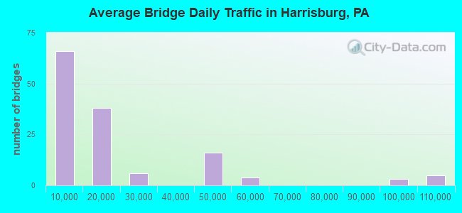
- 2,745,477Total average daily traffic
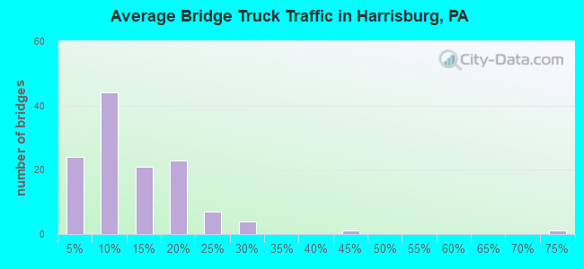
- 389,953Total average daily truck traffic
- National Bridge Inventory (NBI) Registered Bridges for Harrisburg
- No street view available for this location
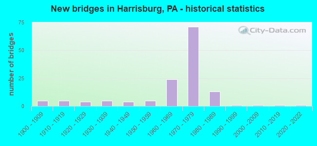
- New bridges - historical statistics
- 51900-1909
- 51910-1919
- 41920-1929
- 51930-1939
- 41940-1949
- 51950-1959
- 241960-1969
- 711970-1979
- 131980-1989
- 11990-1999
- 12000-2009
- 12010-2019
- 12020-2022
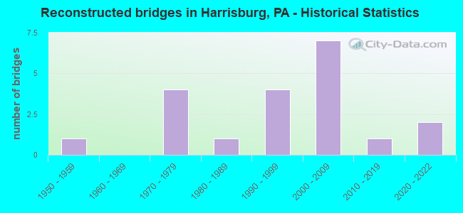
- Reconstructed bridges - Historical Statistics
- 11950-1959
- 01960-1969
- 41970-1979
- 11980-1989
- 41990-1999
- 72000-2009
- 12010-2019
- 22020-2022
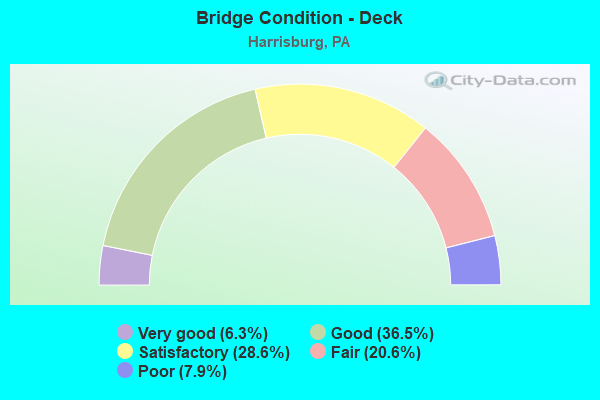
- Bridge Condition - Deck
- 6.3%Very good
- 36.5%Good
- 28.6%Satisfactory
- 20.6%Fair
- 7.9%Poor
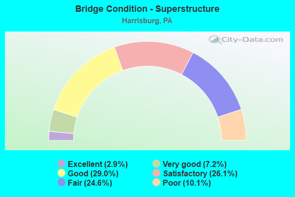
- Bridge Condition - Superstructure
- 2.9%Excellent
- 7.2%Very good
- 29.0%Good
- 26.1%Satisfactory
- 24.6%Fair
- 10.1%Poor
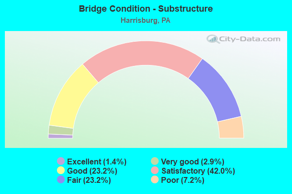
- Bridge Condition - Substructure
- 1.4%Excellent
- 2.9%Very good
- 23.2%Good
- 42.0%Satisfactory
- 23.2%Fair
- 7.2%Poor
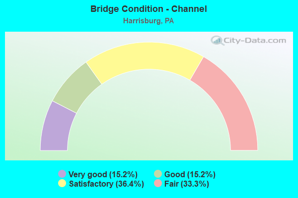
- Bridge Condition - Channel
- 15.2%Very good
- 15.2%Good
- 36.4%Satisfactory
- 33.3%Fair
Find on map >> Show street view
Structure Number: 14172, Location: INTER OF I81 & US22 (Lat: 40.302700, Lng: -76.880489), Route carried "under" structure: Interstate 81, Year Built: 1977, Structure Length: 0. m, Average Daily Traffic: 45,355 (year 2022), Truck Traffic: 18%, Features Intersected: I-81; SR 8003 RP A@B, Facility Carried by Structure: US 22 WB; SR 0022
Minimum Vertical Clearance: 13.11m (43.01ft), Kilometerpoint: 3.415, Lanes on structure: 2, Lanes under structure: 8, Material/Design: Steel continuous, Design/Construction: Stringer/Multi-beam, Length of Maximum Span: 39.3m (128.9ft)
Find on map >> Show street view
Structure Number: 14172, Location: INTER OF I81 & US22 (Lat: 40.302700, Lng: -76.880489), Route carried "under" structure: Ramp State highway , Year Built: 1977, Structure Length: 0. m, Average Daily Traffic: 5,264 (year 2021), Truck Traffic: 7%, Features Intersected: I-81; SR 8003 RP A@B, Facility Carried by Structure: US 22 WB; SR 0022
Minimum Vertical Clearance: 5.15m (16.90ft), Kilometerpoint: 0.000, Lanes on structure: 2, Lanes under structure: 8, Material/Design: Steel continuous, Design/Construction: Stringer/Multi-beam, Length of Maximum Span: 39.3m (128.9ft)
Find on map >> Show street view
Structure Number: 14173, Location: INTER OF I81 & US22 (Lat: 40.301564, Lng: -76.880847), Route carried "under" structure: Ramp State highway , Year Built: 1977, Structure Length: 0. m, Average Daily Traffic: 13,425 (year 2021), Truck Traffic: 17%, Features Intersected: SR 8003; RAMP C, Facility Carried by Structure: US 22 EB; SR 0022
Minimum Vertical Clearance: 11.00m (36.09ft), Kilometerpoint: 0.000, Lanes on structure: 2, Lanes under structure: 1, Material/Design: Steel continuous, Design/Construction: Stringer/Multi-beam, Length of Maximum Span: 29.9m (98.1ft)
Find on map >> Show street view
Structure Number: 14174, Location: INTER OF I81 & US22 (Lat: 40.301597, Lng: -76.880542), Route carried "under" structure: Ramp State highway , Year Built: 1977, Structure Length: 0. m, Average Daily Traffic: 13,425 (year 2021), Truck Traffic: 17%, Features Intersected: SR 8003; RAMP C, Facility Carried by Structure: US 22 WB; SR 0022
Minimum Vertical Clearance: 12.22m (40.09ft), Kilometerpoint: 0.000, Lanes on structure: 2, Lanes under structure: 1, Material/Design: Steel continuous, Design/Construction: Stringer/Multi-beam, Length of Maximum Span: 29.9m (98.1ft)
Find on map >> Show street view
Structure Number: 14196, Location: INTER OF US22 & PA39 (Lat: 40.326092, Lng: -76.890653), Route carried "under" structure: US 22, Year Built: 1971, Structure Length: 0. m, Average Daily Traffic: 24,278 (year 2020), Truck Traffic: 21%, Features Intersected: US 22; SR 0022, Facility Carried by Structure: PA 39; SR 0039
Minimum Vertical Clearance: 4.95m (16.24ft), Kilometerpoint: 18.958, Lanes on structure: 4, Lanes under structure: 4, Material/Design: Steel continuous, Design/Construction: Stringer/Multi-beam, Length of Maximum Span: 35.1m (115.2ft)
Find on map >> Show street view
Structure Number: 14196, Location: INTER OF US22 & PA39 (Lat: 40.326092, Lng: -76.890653), Route carried "under" structure: US 22, Year Built: 1971, Structure Length: 0. m, Average Daily Traffic: 22,218 (year 2020), Truck Traffic: 21%, Features Intersected: US 22; SR 0022, Facility Carried by Structure: PA 39; SR 0039
Minimum Vertical Clearance: 4.57m (14.99ft), Kilometerpoint: 19.002, Lanes on structure: 4, Lanes under structure: 4, Material/Design: Steel continuous, Design/Construction: Stringer/Multi-beam, Length of Maximum Span: 35.1m (115.2ft)
Find on map >> Show street view
Structure Number: 14217, Location: SUSQUEHANNA TWP. (Lat: 40.311667, Lng: -76.900000), Route carried "under" structure: State highway , Year Built: 1972, Structure Length: 0. m, Average Daily Traffic: 4,488 (year 2020), Truck Traffic: 6%, Features Intersected: SR 3009 NB FRONT ST, Facility Carried by Structure: I-81; SR 0081
Minimum Vertical Clearance: 4.70m (15.42ft), Kilometerpoint: 2.757, Lanes on structure: 6, Lanes under structure: 2, Material/Design: Prestressed concrete, Design/Construction: Stringer/Multi-beam, Length of Maximum Span: 32.3m (106.0ft)
Find on map >> Show street view
Structure Number: 14218, Location: NORTH HARRISBURG (Lat: 40.311058, Lng: -76.897661), Route carried "under" structure: Ramp State highway , Year Built: 1972, Structure Length: 0. m, Average Daily Traffic: 1,749 (year 2021), Truck Traffic: 3%, Features Intersected: SR 8001, RAMP E, Facility Carried by Structure: I-81; SR 0081
Minimum Vertical Clearance: 4.52m (14.83ft), Kilometerpoint: 0.000, Lanes on structure: 3, Lanes under structure: 1, Material/Design: Prestressed concrete, Design/Construction: Stringer/Multi-beam, Length of Maximum Span: 26.2m (86.0ft)
Find on map >> Show street view
Structure Number: 14219, Location: CITY OF HARRISBURG (Lat: 40.310131, Lng: -76.894431), Route carried "under" structure: City street , Year Built: 1972, Structure Length: 0. m, Average Daily Traffic: 1 (year 2005), Features Intersected: NORFOLK SOUTHERN, T-310, Facility Carried by Structure: I-81; SR 0081
Minimum Vertical Clearance: 7.16m (23.49ft), Kilometerpoint: 0.000, Lanes on structure: 7, Lanes under structure: 2, Material/Design: Prestressed concrete, Design/Construction: Stringer/Multi-beam, Length of Maximum Span: 28.3m (92.8ft)
Find on map >> Show street view
Structure Number: 14221, Location: OVER INDUSTRIAL HWY. (Lat: 40.306856, Lng: -76.886719), Route carried "under" structure: City street , Year Built: 1975, Structure Length: 0. m, Average Daily Traffic: 1 (year 2005), Features Intersected: INDUSTRIAL HIGHWAY, Facility Carried by Structure: I-81 NB; SR 0081
Minimum Vertical Clearance: 4.55m (14.93ft), Kilometerpoint: 0.000, Lanes on structure: 4, Lanes under structure: 2, Material/Design: Prestressed concrete, Design/Construction: Stringer/Multi-beam, Length of Maximum Span: 23.8m (78.1ft)
Find on map >> Show street view
Structure Number: 14223, Location: OVER IND. HIGHWAY (Lat: 40.307172, Lng: -76.886600), Route carried "under" structure: City street , Year Built: 1975, Structure Length: 0. m, Average Daily Traffic: 1 (year 2005), Features Intersected: INDUSTRAIL HIGHWAY, Facility Carried by Structure: I-81 SB; SR 0081
Minimum Vertical Clearance: 4.72m (15.49ft), Kilometerpoint: 0.000, Lanes on structure: 5, Lanes under structure: 2, Material/Design: Prestressed concrete, Design/Construction: Stringer/Multi-beam, Length of Maximum Span: 23.8m (78.1ft)
Find on map >> Show street view
Structure Number: 14257, Location: JOHN HARRIS BRIDGE; I-83 (Lat: 40.245278, Lng: -76.882717), Route carried "under" structure: Business City street , Year Built: 1960, Structure Length: 0. m, Average Daily Traffic: 150 (year 2018), Truck Traffic: 20%, Features Intersected: SUSQ.RIVER;R.R.LOWTHER S, Facility Carried by Structure: SR 0083; I-83
Minimum Vertical Clearance: 4.57m (14.99ft), Kilometerpoint: 0.000, Lanes on structure: 3, Lanes under structure: 2, Material/Design: Steel continuous, Design/Construction: Girder and Floorbeam System, Length of Maximum Span: 51.8m (169.9ft)
Find on map >> Show street view
Structure Number: 14258, Location: SOUTH HARRISBURG (Lat: 40.250639, Lng: -76.873142), Route carried "under" structure: State highway 230, Year Built: 1960, Structure Length: 0. m, Average Daily Traffic: 6,777 (year 2022), Truck Traffic: 5%, Features Intersected: PA 230;NS;RP B,C;FRONT, Facility Carried by Structure: I-83; SR 0083
Minimum Vertical Clearance: 9.60m (31.50ft), Kilometerpoint: 3.367, Lanes on structure: 3, Lanes under structure: 2, Material/Design: Steel continuous, Design/Construction: Stringer/Multi-beam, Length of Maximum Span: 41.1m (134.8ft)
Find on map >> Show street view
Structure Number: 14258, Location: SOUTH HARRISBURG (Lat: 40.250639, Lng: -76.873142), Route carried "under" structure: State highway 230, Year Built: 1960, Structure Length: 0. m, Average Daily Traffic: 6,777 (year 2022), Truck Traffic: 5%, Features Intersected: PA 230;NS;RP B,C;FRONT, Facility Carried by Structure: I-83; SR 0083
Minimum Vertical Clearance: 9.42m (30.91ft), Kilometerpoint: 3.359, Lanes on structure: 3, Lanes under structure: 2, Material/Design: Steel continuous, Design/Construction: Stringer/Multi-beam, Length of Maximum Span: 41.1m (134.8ft)
Find on map >> Show street view
Structure Number: 14258, Location: SOUTH HARRISBURG (Lat: 40.250639, Lng: -76.873142), Route carried "under" structure: Ramp State highway , Year Built: 1960, Structure Length: 0. m, Average Daily Traffic: 15,716 (year 2021), Truck Traffic: 7%, Features Intersected: PA 230;NS;RP B,C;FRONT, Facility Carried by Structure: I-83; SR 0083
Minimum Vertical Clearance: 4.51m (14.80ft), Kilometerpoint: 0.000, Lanes on structure: 3, Lanes under structure: 1, Material/Design: Steel continuous, Design/Construction: Stringer/Multi-beam, Length of Maximum Span: 41.1m (134.8ft)
Find on map >> Show street view
Structure Number: 14258, Location: SOUTH HARRISBURG (Lat: 40.250639, Lng: -76.873142), Route carried "under" structure: Ramp State highway , Year Built: 1960, Structure Length: 0. m, Average Daily Traffic: 6,721 (year 2021), Truck Traffic: 7%, Features Intersected: PA 230;NS;RP B,C;FRONT, Facility Carried by Structure: I-83; SR 0083
Minimum Vertical Clearance: 6.74m (22.11ft), Kilometerpoint: 0.000, Lanes on structure: 3, Lanes under structure: 1, Material/Design: Steel continuous, Design/Construction: Stringer/Multi-beam, Length of Maximum Span: 41.1m (134.8ft)
Find on map >> Show street view
Structure Number: 14258, Location: SOUTH HARRISBURG (Lat: 40.250639, Lng: -76.873142), Route carried "under" structure: City street , Year Built: 1960, Structure Length: 0. m, Average Daily Traffic: 15,000 (year 1980), Features Intersected: PA 230;NS;RP B,C;FRONT, Facility Carried by Structure: I-83; SR 0083
Minimum Vertical Clearance: 7.94m (26.05ft), Kilometerpoint: 0.000, Lanes on structure: 3, Lanes under structure: 2, Material/Design: Steel continuous, Design/Construction: Stringer/Multi-beam, Length of Maximum Span: 41.1m (134.8ft)
Find on map >> Show street view
Structure Number: 14262, Location: 13TH ST. OVER I-83 (Lat: 40.254325, Lng: -76.864678), Route carried "under" structure: Interstate 83, Year Built: 1981, Structure Length: 0. m, Average Daily Traffic: 50,306 (year 2022), Truck Traffic: 13%, Features Intersected: SR 0083; I-83, Facility Carried by Structure: 13TH STREET
Minimum Vertical Clearance: 4.57m (14.99ft), Kilometerpoint: 1.596, Lanes on structure: 4, Lanes under structure: 6, Material/Design: Steel continuous, Design/Construction: Stringer/Multi-beam, Length of Maximum Span: 45.7m (149.9ft)
Find on map >> Show street view
Structure Number: 14262, Location: 13TH ST. OVER I-83 (Lat: 40.254325, Lng: -76.864678), Route carried "under" structure: Interstate 83, Year Built: 1981, Structure Length: 0. m, Average Daily Traffic: 59,659 (year 2022), Truck Traffic: 11%, Features Intersected: SR 0083; I-83, Facility Carried by Structure: 13TH STREET
Minimum Vertical Clearance: 4.54m (14.90ft), Kilometerpoint: 1.596, Lanes on structure: 4, Lanes under structure: 6, Material/Design: Steel continuous, Design/Construction: Stringer/Multi-beam, Length of Maximum Span: 45.7m (149.9ft)
Find on map >> Show street view
Structure Number: 14264, Location: PAXTON STREET (Lat: 40.255519, Lng: -76.861544), Route carried "under" structure: State highway , Year Built: 1961, Structure Length: 0. m, Average Daily Traffic: 4,906 (year 2022), Truck Traffic: 4%, Features Intersected: SR 3010 & 16TH. ST., Facility Carried by Structure: I-83; SR 0083
Minimum Vertical Clearance: 4.52m (14.83ft), Kilometerpoint: 0.336, Lanes on structure: 6, Lanes under structure: 4, Material/Design: Steel, Design/Construction: Stringer/Multi-beam, Length of Maximum Span: 37.2m (122.0ft)
Find on map >> Show street view
Structure Number: 14264, Location: PAXTON STREET (Lat: 40.255519, Lng: -76.861544), Route carried "under" structure: State highway , Year Built: 1961, Structure Length: 0. m, Average Daily Traffic: 6,288 (year 2022), Truck Traffic: 5%, Features Intersected: SR 3010 & 16TH. ST., Facility Carried by Structure: I-83; SR 0083
Minimum Vertical Clearance: 4.42m (14.50ft), Kilometerpoint: 0.336, Lanes on structure: 6, Lanes under structure: 4, Material/Design: Steel, Design/Construction: Stringer/Multi-beam, Length of Maximum Span: 37.2m (122.0ft)
Find on map >> Show street view
Structure Number: 14264, Location: PAXTON STREET (Lat: 40.255519, Lng: -76.861544), Route carried "under" structure: Business City street , Year Built: 1961, Structure Length: 0. m, Average Daily Traffic: 1 (year 2005), Features Intersected: SR 3010 & 16TH. ST., Facility Carried by Structure: I-83; SR 0083
Minimum Vertical Clearance: 4.29m (14.07ft), Kilometerpoint: 0.000, Lanes on structure: 6, Lanes under structure: 4, Material/Design: Steel, Design/Construction: Stringer/Multi-beam, Length of Maximum Span: 37.2m (122.0ft)
Find on map >> Show street view
Structure Number: 14266, Location: SOUTH HARRISBURG (Lat: 40.256053, Lng: -76.859694), Route carried "under" structure: City street , Year Built: 1961, Structure Length: 0. m, Average Daily Traffic: 10,000 (year 1980), Features Intersected: 17TH ST, Facility Carried by Structure: I-83; SR 0083
Minimum Vertical Clearance: 4.72m (15.49ft), Kilometerpoint: 0.000, Lanes on structure: 7, Lanes under structure: 2, Material/Design: Concrete, Design/Construction: Frame, Length of Maximum Span: 15.2m (49.9ft)
Find on map >> Show street view
Structure Number: 14513, Location: 19 ST CITY OF HARRISBURG (Lat: 40.256886, Lng: -76.855750), Route carried "under" structure: Interstate 83, Year Built: 1961, Structure Length: 0. m, Average Daily Traffic: 50,306 (year 2022), Truck Traffic: 13%, Features Intersected: I-83; SR 0083, Facility Carried by Structure: SR 3007
Minimum Vertical Clearance: 4.34m (14.24ft), Kilometerpoint: 2.367, Lanes on structure: 4, Lanes under structure: 4, Material/Design: Concrete, Design/Construction: Frame, Length of Maximum Span: 21.0m (68.9ft)
Find on map >> Show street view
Structure Number: 14513, Location: 19 ST CITY OF HARRISBURG (Lat: 40.256886, Lng: -76.855750), Route carried "under" structure: Interstate 83, Year Built: 1961, Structure Length: 0. m, Average Daily Traffic: 59,659 (year 2022), Truck Traffic: 11%, Features Intersected: I-83; SR 0083, Facility Carried by Structure: SR 3007
Minimum Vertical Clearance: 4.70m (15.42ft), Kilometerpoint: 2.372, Lanes on structure: 4, Lanes under structure: 4, Material/Design: Concrete, Design/Construction: Frame, Length of Maximum Span: 21.0m (68.9ft)
Find on map >> Show street view
Structure Number: 14532, Location: MULBERRY STREET (Lat: 40.260681, Lng: -76.876781), Route carried "under" structure: Spur State highway 230, Year Built: 1909, Structure Length: 0. m, Average Daily Traffic: 12,242 (year 2020), Truck Traffic: 9%, Features Intersected: SR 0230,AMTRAK, NSRC, Facility Carried by Structure: MULBERRY ST
Minimum Vertical Clearance: 6.10m (20.01ft), Kilometerpoint: 1.736, Lanes on structure: 2, Lanes under structure: 4, Material/Design: Concrete, Design/Construction: Arch - Deck, Length of Maximum Span: 30.8m (101.0ft)
Find on map >> Show street view
Structure Number: 14532, Location: MULBERRY STREET (Lat: 40.260681, Lng: -76.876781), Route carried "under" structure: Spur State highway 230, Year Built: 1909, Structure Length: 0. m, Average Daily Traffic: 9,249 (year 2020), Truck Traffic: 14%, Features Intersected: SR 0230,AMTRAK, NSRC, Facility Carried by Structure: MULBERRY ST
Minimum Vertical Clearance: 6.10m (20.01ft), Kilometerpoint: 1.732, Lanes on structure: 2, Lanes under structure: 4, Material/Design: Concrete, Design/Construction: Arch - Deck, Length of Maximum Span: 30.8m (101.0ft)
Find on map >> Show street view
Structure Number: 14538, Location: STATE STREET (Lat: 40.266064, Lng: -76.879558), Route carried "under" structure: Ramp State highway , Year Built: 1955, Structure Length: 0. m, Average Daily Traffic: 2,702 (year 2022), Truck Traffic: 5%, Features Intersected: WALNUT ST UNDERPASS, Facility Carried by Structure: SR 3014
Minimum Vertical Clearance: 4.29m (14.07ft), Kilometerpoint: 0.000, Lanes on structure: 2, Lanes under structure: 1, Material/Design: Concrete, Design/Construction: Slab, Length of Maximum Span: 11.0m (36.1ft)
Find on map >> Show street view
Structure Number: 14539, Location: STATE ST. BRIDGE, H-BURG (Lat: 40.266197, Lng: -76.879300), Route carried "under" structure: Spur State highway 230, Year Built: 1930, Structure Length: 0. m, Average Daily Traffic: 12,437 (year 2022), Truck Traffic: 11%, Features Intersected: AMTRAK / NSRC / PA 230, Facility Carried by Structure: SR 3014 (STATE ST)
Minimum Vertical Clearance: 11.28m (37.01ft), Kilometerpoint: 1.736, Lanes on structure: 4, Lanes under structure: 4, Material/Design: Concrete, Design/Construction: Arch - Deck, Length of Maximum Span: 32.9m (107.9ft)
Find on map >> Show street view
Structure Number: 14539, Location: STATE ST. BRIDGE, H-BURG (Lat: 40.266197, Lng: -76.879300), Route carried "under" structure: Spur State highway 230, Year Built: 1930, Structure Length: 0. m, Average Daily Traffic: 14,037 (year 2022), Truck Traffic: 11%, Features Intersected: AMTRAK / NSRC / PA 230, Facility Carried by Structure: SR 3014 (STATE ST)
Minimum Vertical Clearance: 11.28m (37.01ft), Kilometerpoint: 1.732, Lanes on structure: 4, Lanes under structure: 4, Material/Design: Concrete, Design/Construction: Arch - Deck, Length of Maximum Span: 32.9m (107.9ft)
Find on map >> Show street view
Structure Number: 14543, Location: City of Harrisburg (Lat: 40.262661, Lng: -76.897583), Route carried "under" structure: US 11, Year Built: 1951, Structure Length: 0. m, Average Daily Traffic: 13,609 (year 2022), Truck Traffic: 2%, Features Intersected: US-11/15;Susquehanna Riv, Facility Carried by Structure: SR 3016;Forster St
Minimum Vertical Clearance: 4.36m (14.30ft), Kilometerpoint: 59.958, Lanes on structure: 2, Lanes under structure: 3, Material/Design: Steel continuous, Design/Construction: Girder and Floorbeam System, Length of Maximum Span: 50.6m (166.0ft)
Find on map >> Show street view
Structure Number: 14557, Location: I-81 & 22-322 INTERCHANGE (Lat: 40.301825, Lng: -76.877094), Route carried "under" structure: Ramp State highway , Year Built: 1974, Structure Length: 0. m, Average Daily Traffic: 14,771 (year 2021), Truck Traffic: 7%, Features Intersected: I-81;RP AF,C,G;PAXTON CK, Facility Carried by Structure: SR 3021; TWP RD
Minimum Vertical Clearance: 5.05m (16.57ft), Kilometerpoint: 0.000, Lanes on structure: 2, Lanes under structure: 2, Material/Design: Steel, Design/Construction: Stringer/Multi-beam, Length of Maximum Span: 32.3m (106.0ft)
Find on map >> Show street view
Structure Number: 14557, Location: I-81 & 22-322 INTERCHANGE (Lat: 40.301825, Lng: -76.877094), Route carried "under" structure: Interstate 81, Year Built: 1974, Structure Length: 0. m, Average Daily Traffic: 45,355 (year 2022), Truck Traffic: 18%, Features Intersected: I-81;RP AF,C,G;PAXTON CK, Facility Carried by Structure: SR 3021; TWP RD
Minimum Vertical Clearance: 6.73m (22.08ft), Kilometerpoint: 3.415, Lanes on structure: 2, Lanes under structure: 3, Material/Design: Steel, Design/Construction: Stringer/Multi-beam, Length of Maximum Span: 32.3m (106.0ft)
Find on map >> Show street view
Structure Number: 14557, Location: I-81 & 22-322 INTERCHANGE (Lat: 40.301825, Lng: -76.877094), Route carried "under" structure: Interstate 81, Year Built: 1974, Structure Length: 0. m, Average Daily Traffic: 48,452 (year 2022), Truck Traffic: 18%, Features Intersected: I-81;RP AF,C,G;PAXTON CK, Facility Carried by Structure: SR 3021; TWP RD
Minimum Vertical Clearance: 6.73m (22.08ft), Kilometerpoint: 3.396, Lanes on structure: 2, Lanes under structure: 3, Material/Design: Steel, Design/Construction: Stringer/Multi-beam, Length of Maximum Span: 32.3m (106.0ft)
Find on map >> Show street view
Structure Number: 14557, Location: I-81 & 22-322 INTERCHANGE (Lat: 40.301825, Lng: -76.877094), Route carried "under" structure: Ramp State highway , Year Built: 1974, Structure Length: 0. m, Average Daily Traffic: 4,432 (year 2021), Truck Traffic: 7%, Features Intersected: I-81;RP AF,C,G;PAXTON CK, Facility Carried by Structure: SR 3021; TWP RD
Minimum Vertical Clearance: 7.09m (23.26ft), Kilometerpoint: 0.000, Lanes on structure: 2, Lanes under structure: 1, Material/Design: Steel, Design/Construction: Stringer/Multi-beam, Length of Maximum Span: 32.3m (106.0ft)
Find on map >> Show street view
Structure Number: 14557, Location: I-81 & 22-322 INTERCHANGE (Lat: 40.301825, Lng: -76.877094), Route carried "under" structure: Ramp State highway , Year Built: 1974, Structure Length: 0. m, Average Daily Traffic: 13,425 (year 2021), Truck Traffic: 17%, Features Intersected: I-81;RP AF,C,G;PAXTON CK, Facility Carried by Structure: SR 3021; TWP RD
Minimum Vertical Clearance: 7.09m (23.26ft), Kilometerpoint: 0.000, Lanes on structure: 2, Lanes under structure: 1, Material/Design: Steel, Design/Construction: Stringer/Multi-beam, Length of Maximum Span: 32.3m (106.0ft)
Find on map >> Show street view
Structure Number: 14741, Location: WLNT ST OVER JONSTN R/HBG (Lat: 40.266828, Lng: -76.873703), Route carried "under" structure: City street , Year Built: 1914, Structure Length: 0. m, Average Daily Traffic: 200 (year 2019), Features Intersected: JONESTOWN ROAD HARRISBUR, Facility Carried by Structure: WALNUT ST
Minimum Vertical Clearance: 3.68m (12.07ft), Kilometerpoint: 0.000, Lanes on structure: 1, Lanes under structure: 2, Material/Design: Concrete, Design/Construction: Arch - Deck, Length of Maximum Span: 7.9m (25.9ft)
Find on map >> Show street view
Structure Number: 14743, Location: PXTN C/S 10TH/MUL RMP/HBG (Lat: 40.261433, Lng: -76.873872), Route carried "under" structure: City street , Year Built: 1910, Structure Length: 0. m, Average Daily Traffic: 300 (year 2019), Truck Traffic: 1%, Features Intersected: S 10TH ST PAXTON CREEK, Facility Carried by Structure: MULBERRY ST RAMP
Minimum Vertical Clearance: 7.57m (24.84ft), Kilometerpoint: 0.000, Lanes on structure: 2, Lanes under structure: 2, Material/Design: Concrete, Design/Construction: Arch - Deck, Length of Maximum Span: 28.7m (94.2ft)
Find on map >> Show street view
Structure Number: 14759, Location: N.END WADE BRIDGE (Lat: 40.311342, Lng: -76.901594), Route carried "under" structure: State highway , Year Built: 1972, Structure Length: 0. m, Average Daily Traffic: 6,855 (year 2020), Truck Traffic: 6%, Features Intersected: FR ST.SR 3009 SUSQ.RIVER, Facility Carried by Structure: RAMP C-C;SR 8001
Minimum Vertical Clearance: 4.44m (14.57ft), Kilometerpoint: 7.343, Lanes on structure: 1, Lanes under structure: 3, Material/Design: Steel, Design/Construction: Stringer/Multi-beam, Length of Maximum Span: 25.3m (83.0ft)
Find on map >> Show street view
Structure Number: 14761, Location: SUSQUEHANNA TWP (Lat: 40.312392, Lng: -76.898486), Route carried "under" structure: State highway , Year Built: 1972, Structure Length: 0. m, Average Daily Traffic: 4,488 (year 2020), Truck Traffic: 6%, Features Intersected: SR 3009, Facility Carried by Structure: SR 8001,RAMP G I81
Minimum Vertical Clearance: 4.62m (15.16ft), Kilometerpoint: 2.757, Lanes on structure: 1, Lanes under structure: 2, Material/Design: Steel, Design/Construction: Stringer/Multi-beam, Length of Maximum Span: 30.8m (101.0ft)
Find on map >> Show street view
Structure Number: 14762, Location: SUSQUEHANNA TWP (Lat: 40.311933, Lng: -76.898633), Route carried "under" structure: State highway , Year Built: 1972, Structure Length: 0. m, Average Daily Traffic: 4,488 (year 2020), Truck Traffic: 6%, Features Intersected: FRONT ST./NB., Facility Carried by Structure: SR 8001,RP E.
Minimum Vertical Clearance: 4.70m (15.42ft), Kilometerpoint: 2.757, Lanes on structure: 1, Lanes under structure: 2, Material/Design: Steel, Design/Construction: Stringer/Multi-beam, Length of Maximum Span: 33.2m (108.9ft)
Find on map >> Show street view
Structure Number: 14763, Location: INTER OF I81 & US 22 (Lat: 40.303414, Lng: -76.879733), Route carried "under" structure: Interstate 81, Year Built: 1977, Structure Length: 0. m, Average Daily Traffic: 45,355 (year 2022), Truck Traffic: 18%, Features Intersected: I-81;US 22/322;RAMPS ABC, Facility Carried by Structure: SR 8003 RAMP D
Minimum Vertical Clearance: 16.36m (53.67ft), Kilometerpoint: 3.415, Lanes on structure: 1, Lanes under structure: 3, Material/Design: Steel continuous, Design/Construction: Stringer/Multi-beam, Length of Maximum Span: 37.2m (122.0ft)
Find on map >> Show street view
Structure Number: 14763, Location: INTER OF I81 & US 22 (Lat: 40.303414, Lng: -76.879733), Route carried "under" structure: US 22, Year Built: 1977, Structure Length: 0. m, Average Daily Traffic: 15,086 (year 2022), Truck Traffic: 14%, Features Intersected: I-81;US 22/322;RAMPS ABC, Facility Carried by Structure: SR 8003 RAMP D
Minimum Vertical Clearance: 5.74m (18.83ft), Kilometerpoint: 21.221, Lanes on structure: 1, Lanes under structure: 2, Material/Design: Steel continuous, Design/Construction: Stringer/Multi-beam, Length of Maximum Span: 37.2m (122.0ft)
Find on map >> Show street view
Structure Number: 14763, Location: INTER OF I81 & US 22 (Lat: 40.303414, Lng: -76.879733), Route carried "under" structure: Ramp State highway , Year Built: 1977, Structure Length: 0. m, Average Daily Traffic: 13,425 (year 2021), Truck Traffic: 17%, Features Intersected: I-81;US 22/322;RAMPS ABC, Facility Carried by Structure: SR 8003 RAMP D
Minimum Vertical Clearance: 11.51m (37.76ft), Kilometerpoint: 0.000, Lanes on structure: 1, Lanes under structure: 1, Material/Design: Steel continuous, Design/Construction: Stringer/Multi-beam, Length of Maximum Span: 37.2m (122.0ft)
Find on map >> Show street view
Structure Number: 14763, Location: INTER OF I81 & US 22 (Lat: 40.303414, Lng: -76.879733), Route carried "under" structure: Ramp State highway , Year Built: 1977, Structure Length: 0. m, Average Daily Traffic: 13,425 (year 2021), Truck Traffic: 17%, Features Intersected: I-81;US 22/322;RAMPS ABC, Facility Carried by Structure: SR 8003 RAMP D
Minimum Vertical Clearance: 5.06m (16.60ft), Kilometerpoint: 0.000, Lanes on structure: 1, Lanes under structure: 1, Material/Design: Steel continuous, Design/Construction: Stringer/Multi-beam, Length of Maximum Span: 37.2m (122.0ft)
Find on map >> Show street view
Structure Number: 14763, Location: INTER OF I81 & US 22 (Lat: 40.303414, Lng: -76.879733), Route carried "under" structure: US 22, Year Built: 1977, Structure Length: 0. m, Average Daily Traffic: 17,543 (year 2022), Truck Traffic: 11%, Features Intersected: I-81;US 22/322;RAMPS ABC, Facility Carried by Structure: SR 8003 RAMP D
Minimum Vertical Clearance: 5.27m (17.29ft), Kilometerpoint: 21.177, Lanes on structure: 1, Lanes under structure: 2, Material/Design: Steel continuous, Design/Construction: Stringer/Multi-beam, Length of Maximum Span: 37.2m (122.0ft)
Find on map >> Show street view
Structure Number: 14763, Location: INTER OF I81 & US 22 (Lat: 40.303414, Lng: -76.879733), Route carried "under" structure: Interstate 81, Year Built: 1977, Structure Length: 0. m, Average Daily Traffic: 48,452 (year 2022), Truck Traffic: 18%, Features Intersected: I-81;US 22/322;RAMPS ABC, Facility Carried by Structure: SR 8003 RAMP D
Minimum Vertical Clearance: 15.06m (49.41ft), Kilometerpoint: 3.396, Lanes on structure: 1, Lanes under structure: 3, Material/Design: Steel continuous, Design/Construction: Stringer/Multi-beam, Length of Maximum Span: 37.2m (122.0ft)
Find on map >> Show street view
Structure Number: 14763, Location: INTER OF I81 & US 22 (Lat: 40.303414, Lng: -76.879733), Route carried "under" structure: Ramp State highway , Year Built: 1977, Structure Length: 0. m, Average Daily Traffic: 5,264 (year 2021), Truck Traffic: 7%, Features Intersected: I-81;US 22/322;RAMPS ABC, Facility Carried by Structure: SR 8003 RAMP D
Minimum Vertical Clearance: 11.07m (36.32ft), Kilometerpoint: 0.000, Lanes on structure: 1, Lanes under structure: 1, Material/Design: Steel continuous, Design/Construction: Stringer/Multi-beam, Length of Maximum Span: 37.2m (122.0ft)
Find on map >> Show street view
Structure Number: 14763, Location: INTER OF I81 & US 22 (Lat: 40.303414, Lng: -76.879733), Route carried "under" structure: Ramp State highway , Year Built: 1977, Structure Length: 0. m, Average Daily Traffic: 2,627 (year 2021), Truck Traffic: 7%, Features Intersected: I-81;US 22/322;RAMPS ABC, Facility Carried by Structure: SR 8003 RAMP D
Minimum Vertical Clearance: 13.49m (44.26ft), Kilometerpoint: 0.000, Lanes on structure: 1, Lanes under structure: 1, Material/Design: Steel continuous, Design/Construction: Stringer/Multi-beam, Length of Maximum Span: 37.2m (122.0ft)
Find on map >> Show street view
Structure Number: 14764, Location: INTER I81 & US22 (Lat: 40.305000, Lng: -76.883333), Route carried "under" structure: Interstate 81, Year Built: 1977, Structure Length: 0. m, Average Daily Traffic: 45,355 (year 2022), Truck Traffic: 18%, Features Intersected: I-81; SR 0081, Facility Carried by Structure: SR 8003; RAMP B
Minimum Vertical Clearance: 6.60m (21.65ft), Kilometerpoint: 3.415, Lanes on structure: 1, Lanes under structure: 6, Material/Design: Steel continuous, Design/Construction: Stringer/Multi-beam, Length of Maximum Span: 37.2m (122.0ft)
Find on map >> Show street view
Structure Number: 14764, Location: INTER I81 & US22 (Lat: 40.305000, Lng: -76.883333), Route carried "under" structure: Interstate 81, Year Built: 1977, Structure Length: 0. m, Average Daily Traffic: 48,452 (year 2022), Truck Traffic: 18%, Features Intersected: I-81; SR 0081, Facility Carried by Structure: SR 8003; RAMP B
Minimum Vertical Clearance: 5.74m (18.83ft), Kilometerpoint: 3.396, Lanes on structure: 1, Lanes under structure: 6, Material/Design: Steel continuous, Design/Construction: Stringer/Multi-beam, Length of Maximum Span: 37.2m (122.0ft)
Find on map >> Show street view
Structure Number: 14765, Location: INTER I81 & US22 (Lat: 40.305000, Lng: -76.883333), Route carried "under" structure: Interstate 81, Year Built: 1977, Structure Length: 0. m, Average Daily Traffic: 45,355 (year 2022), Truck Traffic: 18%, Features Intersected: I-81; SR 8003, RAMP B, Facility Carried by Structure: SR 8003, RAMP C
Minimum Vertical Clearance: 8.23m (27.00ft), Kilometerpoint: 3.415, Lanes on structure: 1, Lanes under structure: 7, Material/Design: Steel continuous, Design/Construction: Stringer/Multi-beam, Length of Maximum Span: 33.8m (110.9ft)
Find on map >> Show street view
Structure Number: 14765, Location: INTER I81 & US22 (Lat: 40.305000, Lng: -76.883333), Route carried "under" structure: Interstate 81, Year Built: 1977, Structure Length: 0. m, Average Daily Traffic: 48,452 (year 2022), Truck Traffic: 18%, Features Intersected: I-81; SR 8003, RAMP B, Facility Carried by Structure: SR 8003, RAMP C
Minimum Vertical Clearance: 8.66m (28.41ft), Kilometerpoint: 3.396, Lanes on structure: 1, Lanes under structure: 7, Material/Design: Steel continuous, Design/Construction: Stringer/Multi-beam, Length of Maximum Span: 33.8m (110.9ft)
Find on map >> Show street view
Structure Number: 14765, Location: INTER I81 & US22 (Lat: 40.305000, Lng: -76.883333), Route carried "under" structure: Ramp State highway , Year Built: 1977, Structure Length: 0. m, Average Daily Traffic: 5,264 (year 2021), Truck Traffic: 7%, Features Intersected: I-81; SR 8003, RAMP B, Facility Carried by Structure: SR 8003, RAMP C
Minimum Vertical Clearance: 5.43m (17.81ft), Kilometerpoint: 0.000, Lanes on structure: 1, Lanes under structure: 7, Material/Design: Steel continuous, Design/Construction: Stringer/Multi-beam, Length of Maximum Span: 33.8m (110.9ft)
Find on map >> Show street view
Structure Number: 14766, Location: INTER OF I81 & US22 (Lat: 40.305000, Lng: -76.883333), Route carried "under" structure: Interstate 81, Year Built: 1977, Structure Length: 0. m, Average Daily Traffic: 48,452 (year 2022), Truck Traffic: 18%, Features Intersected: I-81; SR 0081, Facility Carried by Structure: SR 8003; RAMP A
Minimum Vertical Clearance: 5.97m (19.59ft), Kilometerpoint: 3.396, Lanes on structure: 1, Lanes under structure: 6, Material/Design: Steel continuous, Design/Construction: Stringer/Multi-beam, Length of Maximum Span: 37.8m (124.0ft)
Find on map >> Show street view
Structure Number: 14766, Location: INTER OF I81 & US22 (Lat: 40.305000, Lng: -76.883333), Route carried "under" structure: Interstate 81, Year Built: 1977, Structure Length: 0. m, Average Daily Traffic: 45,355 (year 2022), Truck Traffic: 18%, Features Intersected: I-81; SR 0081, Facility Carried by Structure: SR 8003; RAMP A
Minimum Vertical Clearance: 5.18m (16.99ft), Kilometerpoint: 3.415, Lanes on structure: 1, Lanes under structure: 6, Material/Design: Steel continuous, Design/Construction: Stringer/Multi-beam, Length of Maximum Span: 37.8m (124.0ft)
Find on map >> Show street view
Structure Number: 14767, Location: INTER OF I81 & US22 (Lat: 40.301425, Lng: -76.881403), Route carried "under" structure: Ramp State highway , Year Built: 1977, Structure Length: 0. m, Average Daily Traffic: 13,425 (year 2021), Truck Traffic: 17%, Features Intersected: SR 8003 RAMP C, Facility Carried by Structure: SR 8003 RAMP A
Minimum Vertical Clearance: 5.00m (16.40ft), Kilometerpoint: 0.000, Lanes on structure: 1, Lanes under structure: 1, Material/Design: Steel continuous, Design/Construction: Stringer/Multi-beam, Length of Maximum Span: 30.8m (101.0ft)
Find on map >> Show street view
Structure Number: 14772, Location: SOUTH HARRISBURG (Lat: 40.250531, Lng: -76.873031), Route carried "under" structure: Ramp State highway , Year Built: 1982, Structure Length: 0. m, Average Daily Traffic: 6,721 (year 2021), Truck Traffic: 7%, Features Intersected: SR 8015, RP C; FRONT ST., Facility Carried by Structure: SR 8015, RAMP B
Minimum Vertical Clearance: 4.54m (14.90ft), Kilometerpoint: 0.000, Lanes on structure: 1, Lanes under structure: 3, Material/Design: Steel continuous, Design/Construction: Stringer/Multi-beam, Length of Maximum Span: 51.8m (169.9ft)
Find on map >> Show street view
Structure Number: 14772, Location: SOUTH HARRISBURG (Lat: 40.250531, Lng: -76.873031), Route carried "under" structure: City street , Year Built: 1982, Structure Length: 0. m, Average Daily Traffic: 15,000 (year 1986), Features Intersected: SR 8015, RP C; FRONT ST., Facility Carried by Structure: SR 8015, RAMP B
Minimum Vertical Clearance: 7.32m (24.02ft), Kilometerpoint: 0.000, Lanes on structure: 1, Lanes under structure: 3, Material/Design: Steel continuous, Design/Construction: Stringer/Multi-beam, Length of Maximum Span: 51.8m (169.9ft)
Find on map >> Show street view
Structure Number: 14774, Location: SOUTH HARRISBURG (Lat: 40.250289, Lng: -76.874375), Route carried "under" structure: Ramp State highway , Year Built: 1982, Structure Length: 0. m, Average Daily Traffic: 6,721 (year 2021), Truck Traffic: 7%, Features Intersected: SR 8015 RAMP C, FRONT ST, Facility Carried by Structure: SR 8015, RAMP A
Minimum Vertical Clearance: 7.13m (23.39ft), Kilometerpoint: 0.000, Lanes on structure: 1, Lanes under structure: 3, Material/Design: Steel continuous, Design/Construction: Stringer/Multi-beam, Length of Maximum Span: 32.0m (105.0ft)
Find on map >> Show street view
Structure Number: 14774, Location: SOUTH HARRISBURG (Lat: 40.250289, Lng: -76.874375), Route carried "under" structure: City street , Year Built: 1982, Structure Length: 0. m, Average Daily Traffic: 15,000 (year 1980), Features Intersected: SR 8015 RAMP C, FRONT ST, Facility Carried by Structure: SR 8015, RAMP A
Minimum Vertical Clearance: 7.96m (26.12ft), Kilometerpoint: 0.000, Lanes on structure: 1, Lanes under structure: 3, Material/Design: Steel continuous, Design/Construction: Stringer/Multi-beam, Length of Maximum Span: 32.0m (105.0ft)
Find on map >> Show street view
Structure Number: 14775, Location: SOUTH HARRISBURG (Lat: 40.252472, Lng: -76.870167), Route carried "under" structure: Ramp State highway , Year Built: 1982, Structure Length: 0. m, Average Daily Traffic: 15,716 (year 2021), Truck Traffic: 7%, Features Intersected: RP B; AMTRK, PENNSY, NFS, Facility Carried by Structure: SR8015,EXIT RAMP D
Minimum Vertical Clearance: 6.98m (22.90ft), Kilometerpoint: 0.000, Lanes on structure: 1, Lanes under structure: 1, Material/Design: Steel continuous, Design/Construction: Stringer/Multi-beam, Length of Maximum Span: 36.6m (120.1ft)