Bridge Statistics for Harrison, Arkansas (AR)
Condition, Traffic, Stress, Structural Evaluation, Project Costs
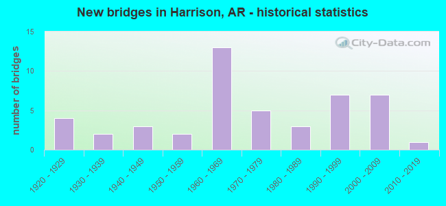
- New bridges - historical statistics
- 41920-1929
- 21930-1939
- 31940-1949
- 21950-1959
- 131960-1969
- 51970-1979
- 31980-1989
- 71990-1999
- 72000-2009
- 12010-2019
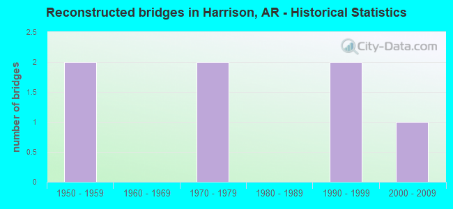
- Reconstructed bridges - Historical Statistics
- 21950-1959
- 01960-1969
- 21970-1979
- 01980-1989
- 21990-1999
- 12000-2009
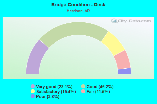
- Bridge Condition - Deck
- 23.1%Very good
- 46.2%Good
- 15.4%Satisfactory
- 11.5%Fair
- 3.8%Poor
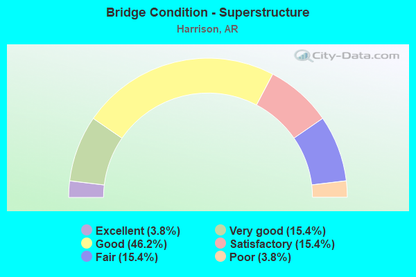
- Bridge Condition - Superstructure
- 3.8%Excellent
- 15.4%Very good
- 46.2%Good
- 15.4%Satisfactory
- 15.4%Fair
- 3.8%Poor
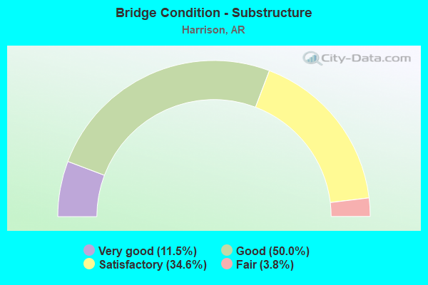
- Bridge Condition - Substructure
- 11.5%Very good
- 50.0%Good
- 34.6%Satisfactory
- 3.8%Fair
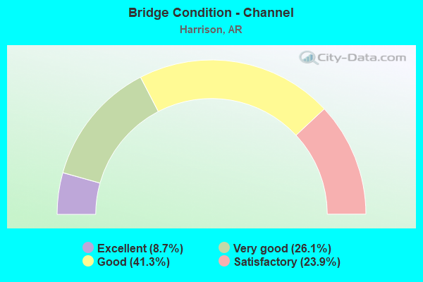
- Bridge Condition - Channel
- 8.7%Excellent
- 26.1%Very good
- 41.3%Good
- 23.9%Satisfactory
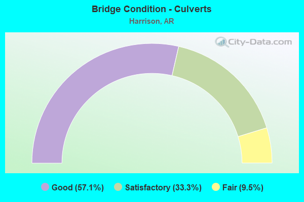
- Bridge Condition - Culverts
- 57.1%Good
- 33.3%Satisfactory
- 9.5%Fair
Find on map >> Show street view
Structure Number: X0403, Location: 5.2MI NE JCT SH 7 & 65N (Lat: 36.280253, Lng: -93.162622), Route carried "on" structure: Other road , Year Built: 1979, Status: Open, Structure Length: 0.70m (2.30ft), Average Daily Traffic: 420 (year 2018), Truck Traffic: 1%, Average Future Daily Traffic: 165 (year 2033), Design Load: H 20, Features Intersected: DITCH, Facility Carried by Structure: US 65 R-Area Boone
Minimum Vertical Clearance: 30+ m (98+ ft), Kilometerpoint: 0.032, Lanes on structure: 2, Owner: State Highway Agency, Approaching Roadway Width: 11.0m (36.1ft), Material/Design: Concrete, Design/Construction: Culvert, Number Of Spans In Main Unit: 3, Length of Maximum Span: 2.4m (7.9ft)
Condition: Channel: Very good, Culverts: Good, Operating Rating: 47.2 metric tons, Method Used To Determine Operating Rating: Load Factor (LF), Inventory Rating: 28.1 metric tons, Method Used To Determine Inventory Rating: Load Factor (LF), Structural Evaluation: Better than present minimum criteria, Waterway Adequacy: Equal to present desirable criteria, Approach Roadway Alignment: Equal to present desirable criteria, Designated Inspection Frequency: Every 24 months, Critical Feature Inspection Frequency: Every 24 months, Inspection Date: July 2020
Find on map >> Show street view
Structure Number: X0406, Location: 1MI NW OF JCT SH 43 (Lat: 36.263347, Lng: -93.134753), Route carried "on" structure: US 65, Year Built: 1979, Status: Open, Structure Length: 0.70m (2.30ft), Average Daily Traffic: 25,538 (year 2018), Truck Traffic: 1%, Average Future Daily Traffic: 33,835 (year 2028), Design Load: H 20, Features Intersected: DITCH
Minimum Vertical Clearance: 30+ m (98+ ft), Kilometerpoint: 29.483, Lanes on structure: 5, Base Highway Network: Yes, Owner: State Highway Agency, Approaching Roadway Width: 18.3m (60.0ft), Skew: 4 degrees, Material/Design: Concrete, Design/Construction: Culvert, Number Of Spans In Main Unit: 3, Length of Maximum Span: 2.4m (7.9ft)
Condition: Channel: Satisfactory, Culverts: Satisfactory, Operating Rating: 47.2 metric tons, Method Used To Determine Operating Rating: Load Factor (LF), Inventory Rating: 28.1 metric tons, Method Used To Determine Inventory Rating: Load Factor (LF), Structural Evaluation: Equal to present minimum criteria, Waterway Adequacy: Better than present minimum criteria, Approach Roadway Alignment: Equal to present desirable criteria, Designated Inspection Frequency: Every 24 months, Critical Feature Inspection Frequency: Every 24 months, Inspection Date: July 2020
Find on map >> Show street view
Structure Number: X1308, Location: 0.4 MI N JCT US 412 (Lat: 36.299931, Lng: -93.194817), Route carried "on" structure: US 65, Year Built: 2007, Status: Open, Structure Length: 0.85m (2.79ft), Average Daily Traffic: 9,825 (year 2018), Truck Traffic: 11%, Average Future Daily Traffic: 13,013 (year 2028), Design Load: H 20, Features Intersected: ROLANDS FORK
Minimum Vertical Clearance: 30+ m (98+ ft), Kilometerpoint: 23.062, Lanes on structure: 4, Base Highway Network: Yes, Owner: State Highway Agency, Approaching Roadway Width: 24.4m (80.1ft), Skew: 2 degrees, Material/Design: Concrete, Design/Construction: Culvert, Number Of Spans In Main Unit: 3, Length of Maximum Span: 3.0m (9.8ft)
Condition: Channel: Excellent, Culverts: Good, Operating Rating: 54.4 metric tons, Method Used To Determine Operating Rating: Load Factor (LF), Inventory Rating: 32.7 metric tons, Method Used To Determine Inventory Rating: Load Factor (LF), Structural Evaluation: Better than present minimum criteria, Waterway Adequacy: Superior to present desirable criteria, Approach Roadway Alignment: Superior to present desirable criteria, Designated Inspection Frequency: Every 24 months, Critical Feature Inspection Frequency: Every 24 months, Inspection Date: October 2021
Find on map >> Show street view
Structure Number: X1314, Location: 0.5 MI S JCT US 412 (Lat: 36.289369, Lng: -93.181336), Route carried "on" structure: US 65, Year Built: 2007, Status: Open, Structure Length: 0.82m (2.69ft), Average Daily Traffic: 17,000 (year 2018), Truck Traffic: 11%, Average Future Daily Traffic: 13,013 (year 2028), Design Load: H 20, Features Intersected: DRY CREEK
Minimum Vertical Clearance: 30+ m (98+ ft), Kilometerpoint: 24.575, Lanes on structure: 5, Base Highway Network: Yes, Owner: State Highway Agency, Approaching Roadway Width: 18.3m (60.0ft), Material/Design: Concrete, Design/Construction: Culvert, Number Of Spans In Main Unit: 3, Length of Maximum Span: 2.7m (8.9ft)
Condition: Channel: Excellent, Culverts: Good, Operating Rating: 47.2 metric tons, Method Used To Determine Operating Rating: Load Factor (LF), Inventory Rating: 28.1 metric tons, Method Used To Determine Inventory Rating: Load Factor (LF), Structural Evaluation: Better than present minimum criteria, Waterway Adequacy: Superior to present desirable criteria, Approach Roadway Alignment: Superior to present desirable criteria, Designated Inspection Frequency: Every 24 months, Critical Feature Inspection Frequency: Every 24 months, Inspection Date: October 2021
Find on map >> Show street view
Structure Number: X1315, Location: 0.7 MI S JCT US 412 (Lat: 36.290203, Lng: -93.183511), Route carried "on" structure: US 65, Year Built: 2007, Status: Open, Structure Length: 1.77m (5.81ft), Average Daily Traffic: 17,000 (year 2018), Truck Traffic: 11%, Average Future Daily Traffic: 13,013 (year 2028), Design Load: H 20, Features Intersected: REST AREA CREEK
Minimum Vertical Clearance: 30+ m (98+ ft), Kilometerpoint: 24.752, Lanes on structure: 5, Base Highway Network: Yes, Owner: State Highway Agency, Approaching Roadway Width: 18.3m (60.0ft), Skew: 6 degrees, Material/Design: Concrete, Design/Construction: Culvert, Number Of Spans In Main Unit: 3, Length of Maximum Span: 6.1m (20.0ft)
Condition: Channel: Excellent, Culverts: Good, Operating Rating: 50.8 metric tons, Method Used To Determine Operating Rating: Load Factor (LF), Inventory Rating: 30.8 metric tons, Method Used To Determine Inventory Rating: Load Factor (LF), Structural Evaluation: Better than present minimum criteria, Waterway Adequacy: Superior to present desirable criteria, Approach Roadway Alignment: Superior to present desirable criteria, Designated Inspection Frequency: Every 24 months, Critical Feature Inspection Frequency: Every 24 months, Inspection Date: October 2021
Find on map >> Show street view
Structure Number: 6683, Location: 6.1 M E CARROLL CO. (Lat: 36.298700, Lng: -93.193711), Route carried "under" structure: US 65, Structure Length: 0. m, Average Daily Traffic: 4,850 (year 2014), Truck Traffic: 1%, Features Intersected: US 65, Facility Carried by Structure: US 62 Ramp Boone
Minimum Vertical Clearance: 4.90m (16.08ft), Kilometerpoint: 23.191, Length of Maximum Span: 0.0m
Find on map >> Show street view
Structure Number: 6683, Location: 6.1 M E CARROLL CO. (Lat: 36.298700, Lng: -93.193711), Route carried "under" structure: US 65, Structure Length: 0. m, Average Daily Traffic: 4,850 (year 2014), Truck Traffic: 1%, Features Intersected: US 65, Facility Carried by Structure: US 62 Ramp Boone
Minimum Vertical Clearance: 5.15m (16.90ft), Kilometerpoint: 23.191, Length of Maximum Span: 0.0m