Bridge Statistics for Harrisonville, Missouri (MO)
Condition, Traffic, Stress, Structural Evaluation, Project Costs
- National Bridge Inventory (NBI) Statistics
- 80Number of bridges
- 509ft / 155mTotal length
- $2,767,000Total costs
- 496,078Total average daily traffic
- 103,013Total average daily truck traffic
- National Bridge Inventory (NBI) Registered Bridges for Harrisonville
- No street view available for this location
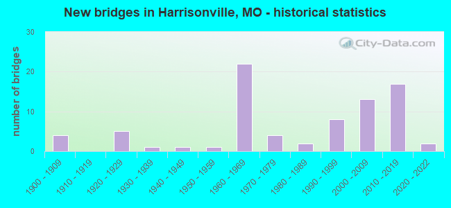
- New bridges - historical statistics
- 41900-1909
- 51920-1929
- 11930-1939
- 11940-1949
- 11950-1959
- 221960-1969
- 41970-1979
- 21980-1989
- 81990-1999
- 132000-2009
- 172010-2019
- 22020-2022
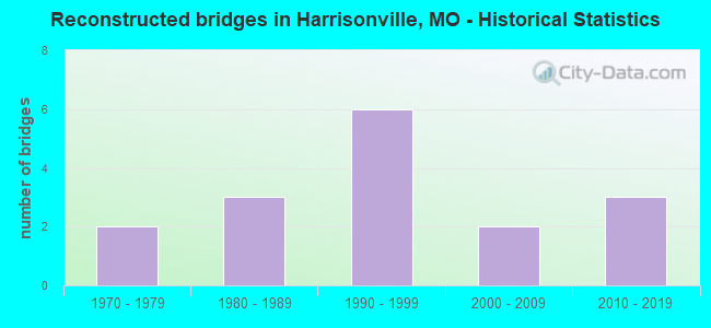
- Reconstructed bridges - Historical Statistics
- 21970-1979
- 31980-1989
- 61990-1999
- 22000-2009
- 32010-2019
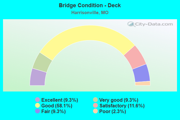
- Bridge Condition - Deck
- 9.3%Excellent
- 9.3%Very good
- 58.1%Good
- 11.6%Satisfactory
- 9.3%Fair
- 2.3%Poor
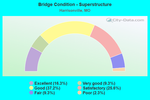
- Bridge Condition - Superstructure
- 16.3%Excellent
- 9.3%Very good
- 37.2%Good
- 25.6%Satisfactory
- 9.3%Fair
- 2.3%Poor
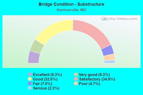
- Bridge Condition - Substructure
- 9.3%Excellent
- 9.3%Very good
- 32.6%Good
- 34.9%Satisfactory
- 7.0%Fair
- 4.7%Poor
- 2.3%Serious
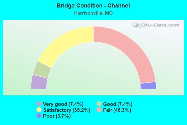
- Bridge Condition - Channel
- 7.4%Very good
- 7.4%Good
- 35.2%Satisfactory
- 46.3%Fair
- 3.7%Poor
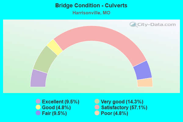
- Bridge Condition - Culverts
- 9.5%Excellent
- 14.3%Very good
- 4.8%Good
- 57.1%Satisfactory
- 9.5%Fair
- 4.8%Poor
Find on map >> Show street view
Structure Number: 32788, Location: S 16 T 44 N R 31 W (Lat: 38.573914, Lng: -94.338783), Route carried "on" structure: County highway , Year Built: 2009, Status: Open, Structure Length: 1.28m (4.20ft), Average Daily Traffic: 100 (year 2021), Truck Traffic: 5%, Average Future Daily Traffic: 160 (year 2041), Features Intersected: TENNESSEE CR, Facility Carried by Structure: 299TH ST
Minimum Vertical Clearance: 30+ m (98+ ft), Kilometerpoint: 0.000, Lanes on structure: 2, Owner: County Highway Agency, Approaching Roadway Width: 9.1m (29.9ft), Material/Design: Steel, Design/Construction: Stringer/Multi-beam, Number Of Spans In Main Unit: 1, Length of Maximum Span: 11.6m (38.1ft), Curb-To-Curb Width: 7.2m (23.6ft), Out-to-Out Width: 7.4m (24.3ft)
Condition: Deck: Good, Superstructure: Good, Substructure: Good, Channel: Satisfactory, Operating Rating: 52.2 metric tons, Method Used To Determine Operating Rating: Load Factor (LF), Inventory Rating: 31.5 metric tons, Method Used To Determine Inventory Rating: Load Factor (LF), Structural Evaluation: Better than present minimum criteria, Deck Geometry: Somewhat better than minimum adequacy, Waterway Adequacy: Equal to present desirable criteria, Approach Roadway Alignment: Equal to present desirable criteria, Designated Inspection Frequency: Every 24 months, Inspection Date: April 2021, Deck Structure Type: Concrete Cast-file-Place, Wearing Surface/Protective System: Wearing Surface: Monolithic Concrete
Find on map >> Show street view
Structure Number: 3279, Location: S 18 T 44 N R 31 W (Lat: 38.606011, Lng: -94.385703), Route carried "on" structure: County highway , Year Built: 2008, Status: Open, Structure Length: 1.13m (3.71ft), Average Daily Traffic: 50 (year 2021), Truck Traffic: 5%, Average Future Daily Traffic: 80 (year 2041), Features Intersected: BR OF EAST CR, Facility Carried by Structure: BURFORD RD
Minimum Vertical Clearance: 30+ m (98+ ft), Kilometerpoint: 0.000, Lanes on structure: 2, Owner: County Highway Agency, Approaching Roadway Width: 9.1m (29.9ft), Material/Design: Steel, Design/Construction: Stringer/Multi-beam, Number Of Spans In Main Unit: 1, Length of Maximum Span: 10.1m (33.1ft), Curb-To-Curb Width: 7.1m (23.3ft), Out-to-Out Width: 7.3m (24.0ft)
Condition: Deck: Good, Superstructure: Good, Substructure: Good, Channel: Satisfactory, Operating Rating: 56.7 metric tons, Method Used To Determine Operating Rating: Load Factor (LF), Inventory Rating: 34.2 metric tons, Method Used To Determine Inventory Rating: Load Factor (LF), Structural Evaluation: Better than present minimum criteria, Deck Geometry: Somewhat better than minimum adequacy, Waterway Adequacy: Better than present minimum criteria, Approach Roadway Alignment: Equal to present minimum criteria, Designated Inspection Frequency: Every 24 months, Inspection Date: March 2021, Deck Structure Type: Concrete Cast-file-Place, Wearing Surface/Protective System: Wearing Surface: Monolithic Concrete
Find on map >> Show street view
Structure Number: 33784, Location: S 16 T 44 N R 31 W (Lat: 38.603081, Lng: -94.348944), Route carried "on" structure: County highway , Year Built: 2011, Status: Open, Structure Length: 5.66m (18.57ft), Average Daily Traffic: 98 (year 2021), Truck Traffic: 9%, Average Future Daily Traffic: 162 (year 2041), Features Intersected: IS 49, Facility Carried by Structure: 283RD ST E
Minimum Vertical Clearance: 30+ m (98+ ft), Kilometerpoint: 1.559, Lanes on structure: 2, Lanes under structure: 4, Owner: State Highway Agency, Approaching Roadway Width: 8.5m (27.9ft), Material/Design: Prestressed concrete, Design/Construction: Stringer/Multi-beam, Number Of Spans In Main Unit: 2, Length of Maximum Span: 28.0m (91.9ft), Curb-To-Curb Width: 8.5m (27.9ft), Out-to-Out Width: 9.3m (30.5ft)
Condition: Deck: Very good, Superstructure: Excellent, Substructure: Excellent, Operating Rating: 59.4 metric tons, Method Used To Determine Operating Rating: Load Factor (LF), Inventory Rating: 36.0 metric tons, Method Used To Determine Inventory Rating: Load Factor (LF), Structural Evaluation: Superior to present desirable criteria, Deck Geometry: Better than present minimum criteria, Approach Roadway Alignment: Equal to present desirable criteria, Designated Inspection Frequency: Every 24 months, Inspection Date: November 2021, Deck Structure Type: Concrete Cast-file-Place, Wearing Surface/Protective System: Wearing Surface: Monolithic Concrete, Deck Protection: Epoxy Coated Reinforcing
Find on map >> Show street view
Structure Number: 33801, Location: S 4 T 44 N R 31 W (Lat: 38.559583, Lng: -94.351167), Route carried "on" structure: County highway , Year Built: 2011, Status: Open, Structure Length: 5.66m (18.57ft), Average Daily Traffic: 969 (year 2021), Truck Traffic: 10%, Average Future Daily Traffic: 1,599 (year 2041), Features Intersected: IS 49, Facility Carried by Structure: 307TH ST E
Minimum Vertical Clearance: 30+ m (98+ ft), Kilometerpoint: 8.027, Lanes on structure: 2, Lanes under structure: 4, Owner: State Highway Agency, Approaching Roadway Width: 8.5m (27.9ft), Material/Design: Prestressed concrete, Design/Construction: Stringer/Multi-beam, Number Of Spans In Main Unit: 2, Length of Maximum Span: 28.0m (91.9ft), Curb-To-Curb Width: 8.5m (27.9ft), Out-to-Out Width: 9.3m (30.5ft)
Condition: Deck: Very good, Superstructure: Excellent, Substructure: Excellent, Operating Rating: 60.3 metric tons, Method Used To Determine Operating Rating: Load Factor (LF), Inventory Rating: 36.0 metric tons, Method Used To Determine Inventory Rating: Load Factor (LF), Structural Evaluation: Superior to present desirable criteria, Deck Geometry: Somewhat better than minimum adequacy, Underclear: Equal to present minimum criteria, Approach Roadway Alignment: Equal to present desirable criteria, Designated Inspection Frequency: Every 24 months, Inspection Date: November 2021, Deck Structure Type: Concrete Cast-file-Place, Wearing Surface/Protective System: Wearing Surface: Monolithic Concrete, Deck Protection: Epoxy Coated Reinforcing
Find on map >> Show street view
Structure Number: 33872, Location: S 13 T 45 N R 31 W (Lat: 38.711667, Lng: -94.299372), Route carried "on" structure: State highway 7, Year Built: 2012, Status: Open, Structure Length: 0.79m (2.59ft), Average Daily Traffic: 3,184 (year 2021), Truck Traffic: 10%, Average Future Daily Traffic: 5,890 (year 2041), Features Intersected: BR
Minimum Vertical Clearance: 30+ m (98+ ft), Kilometerpoint: 49.463, Lanes on structure: 2, Base Highway Network: Yes, Owner: State Highway Agency, Approaching Roadway Width: 7.3m (24.0ft), Material/Design: Concrete, Design/Construction: Culvert, Number Of Spans In Main Unit: 2, Length of Maximum Span: 4.3m (14.1ft), Out-to-Out Width: 7.3m (24.0ft)
Condition: Channel: Satisfactory, Culverts: Satisfactory, Inventory Rating: 64.8 metric tons, Method Used To Determine Inventory Rating: Field evaluation and documented engineering judgment, Structural Evaluation: Equal to present minimum criteria, Waterway Adequacy: Superior to present desirable criteria, Approach Roadway Alignment: Equal to present desirable criteria, Designated Inspection Frequency: Every 24 months, Inspection Date: November 2021
Find on map >> Show street view
Structure Number: 34483, Location: S 4 T 44 N R 31 W (Lat: 38.660278, Lng: -94.348611), Route carried "on" structure: City street , Year Built: 2013, Status: Open, Structure Length: 0.74m (2.43ft), Average Daily Traffic: 4,100 (year 2021), Truck Traffic: 10%, Average Future Daily Traffic: 6,560 (year 2041), Design Load: HS 20, Features Intersected: TOWN CR, Facility Carried by Structure: N INDEPENDENCE AVE
Minimum Vertical Clearance: 30+ m (98+ ft), Kilometerpoint: 0.966, Lanes on structure: 2, Owner: City or Municipal Highway Agency, Approaching Roadway Width: 8.8m (28.9ft), Material/Design: Steel, Design/Construction: Arch - Deck, Number Of Spans In Main Unit: 1, Length of Maximum Span: 7.4m (24.3ft), Curb or Sidewalk Widths: Left: 3.0m (9.8ft), Right: 1.8m (5.9ft), Curb-To-Curb Width: 9.1m (29.9ft), Out-to-Out Width: 14.0m (45.9ft)
Condition: Deck: Excellent, Superstructure: Good, Substructure: Good, Channel: Very good, Operating Rating: 54.0 metric tons, Method Used To Determine Operating Rating: Load Factor (LF), Inventory Rating: 32.4 metric tons, Method Used To Determine Inventory Rating: Load Factor (LF), Structural Evaluation: Better than present minimum criteria, Deck Geometry: Meets minimum limits, Waterway Adequacy: Superior to present desirable criteria, Approach Roadway Alignment: Equal to present desirable criteria, Designated Inspection Frequency: Every 24 months, Inspection Date: March 2021, Deck Structure Type: Concrete Cast-file-Place, Wearing Surface/Protective System: Wearing Surface: Monolithic Concrete
Find on map >> Show street view
Structure Number: 34687, Location: S 5 T 41 N R 31 W (Lat: 38.660600, Lng: -94.368800), Route carried "on" structure: State highway 291, Year Built: 2014, Status: Open, Structure Length: 5.91m (19.39ft), Average Daily Traffic: 5,999 (year 2021), Truck Traffic: 9%, Average Future Daily Traffic: 11,098 (year 2041), Features Intersected: IS 49
Minimum Vertical Clearance: 30+ m (98+ ft), Kilometerpoint: 79.333, Lanes on structure: 2, Lanes under structure: 4, Base Highway Network: Yes, Owner: State Highway Agency, Approaching Roadway Width: 10.7m (35.1ft), Material/Design: Prestressed concrete continuous, Design/Construction: Stringer/Multi-beam, Number Of Spans In Main Unit: 2, Length of Maximum Span: 28.9m (94.8ft), Curb-To-Curb Width: 9.8m (32.2ft), Out-to-Out Width: 10.7m (35.1ft)
Condition: Deck: Good, Superstructure: Excellent, Substructure: Very good, Operating Rating: 66.6 metric tons, Method Used To Determine Operating Rating: Load Factor (LF), Inventory Rating: 39.6 metric tons, Method Used To Determine Inventory Rating: Load Factor (LF), Structural Evaluation: Equal to present desirable criteria, Deck Geometry: Meets minimum limits, Underclear: Equal to present minimum criteria, Approach Roadway Alignment: Equal to present desirable criteria, Designated Inspection Frequency: Every 24 months, Inspection Date: November 2021, Deck Structure Type: Concrete Cast-file-Place, Wearing Surface/Protective System: Wearing Surface: Monolithic Concrete, Deck Protection: Epoxy Coated Reinforcing
Find on map >> Show street view
Structure Number: 3469, Location: S 20 T 24 N R 1 E (Lat: 36.716625, Lng: -90.975222), Route carried "on" structure: State highway C, Year Built: 1982, Status: Open, Structure Length: 9.17m (30.09ft), Average Daily Traffic: 161 (year 2021), Truck Traffic: 5%, Average Future Daily Traffic: 225 (year 2041), Design Load: H 15, Features Intersected: BUFFALO CR
Minimum Vertical Clearance: 30+ m (98+ ft), Kilometerpoint: 37.095, Lanes on structure: 2, Owner: State Highway Agency, Approaching Roadway Width: 6.4m (21.0ft), Skew: 1 degrees, Material/Design: Prestressed concrete, Design/Construction: Stringer/Multi-beam, Number Of Spans In Main Unit: 1, Number Of Approach Spans: 5, Length of Maximum Span: 29.0m (95.1ft), Curb or Sidewalk Widths: Left: 0.2m (0.7ft), Right: 0.2m (0.7ft), Curb-To-Curb Width: 8.2m (26.9ft), Out-to-Out Width: 9.0m (29.5ft)
Condition: Deck: Satisfactory, Superstructure: Very good, Substructure: Satisfactory, Channel: Fair, Operating Rating: 54.0 metric tons, Method Used To Determine Operating Rating: Load Factor (LF), Inventory Rating: 27.0 metric tons, Method Used To Determine Inventory Rating: Load Factor (LF), Structural Evaluation: Equal to present minimum criteria, Deck Geometry: Somewhat better than minimum adequacy, Waterway Adequacy: Equal to present desirable criteria, Approach Roadway Alignment: Equal to present desirable criteria, Designated Inspection Frequency: Every 24 months, Inspection Date: January 2022, Deck Structure Type: Concrete Cast-file-Place, Wearing Surface/Protective System: Wearing Surface: Bituminous, Deck Protection: Epoxy Coated Reinforcing
Find on map >> Show street view
Structure Number: 3469, Location: S 5 T 41 N R 31 W (Lat: 38.660600, Lng: -94.368800), Route carried "on" structure: State highway 291, Year Built: 2014, Status: Open, Structure Length: 5.91m (19.39ft), Average Daily Traffic: 6,532 (year 2021), Truck Traffic: 9%, Average Future Daily Traffic: 12,084 (year 2041), Features Intersected: IS 49
Minimum Vertical Clearance: 30+ m (98+ ft), Kilometerpoint: 0.079, Lanes on structure: 2, Lanes under structure: 4, Base Highway Network: Yes, Owner: State Highway Agency, Approaching Roadway Width: 9.8m (32.2ft), Material/Design: Prestressed concrete continuous, Design/Construction: Stringer/Multi-beam, Number Of Spans In Main Unit: 2, Length of Maximum Span: 28.9m (94.8ft), Curb-To-Curb Width: 9.8m (32.2ft), Out-to-Out Width: 12.6m (41.3ft)
Condition: Deck: Good, Superstructure: Excellent, Substructure: Excellent, Operating Rating: 65.7 metric tons, Method Used To Determine Operating Rating: Load Factor (LF), Inventory Rating: 39.6 metric tons, Method Used To Determine Inventory Rating: Load Factor (LF), Structural Evaluation: Superior to present desirable criteria, Deck Geometry: Meets minimum limits, Underclear: Better than present minimum criteria, Approach Roadway Alignment: Equal to present desirable criteria, Designated Inspection Frequency: Every 24 months, Inspection Date: November 2021, Deck Structure Type: Concrete Cast-file-Place, Wearing Surface/Protective System: Wearing Surface: Monolithic Concrete, Deck Protection: Epoxy Coated Reinforcing
Find on map >> Show street view
Structure Number: 34976, Location: S 15 T 45 N R 31 W (Lat: 38.710750, Lng: -94.331306), Route carried "on" structure: County highway 278, Year Built: 2012, Status: Open, Structure Length: 0.68m (2.23ft), Average Daily Traffic: 100 (year 2021), Truck Traffic: 10%, Average Future Daily Traffic: 160 (year 2041), Design Load: HS 20, Features Intersected: TRIB CAMP CR, Facility Carried by Structure: ORE RD
Minimum Vertical Clearance: 30+ m (98+ ft), Kilometerpoint: 2.736, Lanes on structure: 2, Owner: County Highway Agency, Approaching Roadway Width: 7.9m (25.9ft), Material/Design: Aluminum, Iron, Design/Construction: Culvert, Number Of Spans In Main Unit: 1, Length of Maximum Span: 6.8m (22.3ft)
Condition: Channel: Good, Culverts: Very good, Operating Rating: 54.0 metric tons, Method Used To Determine Operating Rating: Field evaluation and documented engineering judgment, Inventory Rating: 32.4 metric tons, Method Used To Determine Inventory Rating: Field evaluation and documented engineering judgment, Structural Evaluation: Equal to present desirable criteria, Waterway Adequacy: Better than present minimum criteria, Approach Roadway Alignment: Equal to present desirable criteria, Designated Inspection Frequency: Every 24 months, Inspection Date: April 2021
Find on map >> Show street view
Structure Number: 34977, Location: S 5 T 44 N R 31 W (Lat: 38.654694, Lng: -94.370000), Route carried "on" structure: County highway 331, Year Built: 2001, Status: Open, Structure Length: 0.66m (2.17ft), Average Daily Traffic: 100 (year 2021), Truck Traffic: 10%, Average Future Daily Traffic: 160 (year 2041), Design Load: HS 20, Features Intersected: TRIB MUDDY CR, Facility Carried by Structure: 255TH ST
Minimum Vertical Clearance: 30+ m (98+ ft), Kilometerpoint: 0.805, Lanes on structure: 2, Owner: County Highway Agency, Approaching Roadway Width: 7.9m (25.9ft), Material/Design: Aluminum, Iron, Design/Construction: Culvert, Number Of Spans In Main Unit: 1, Length of Maximum Span: 6.6m (21.7ft)
Condition: Channel: Fair, Culverts: Very good, Operating Rating: 54.0 metric tons, Method Used To Determine Operating Rating: Field evaluation and documented engineering judgment, Inventory Rating: 32.4 metric tons, Method Used To Determine Inventory Rating: Field evaluation and documented engineering judgment, Structural Evaluation: Equal to present desirable criteria, Waterway Adequacy: Equal to present minimum criteria, Approach Roadway Alignment: Equal to present desirable criteria, Designated Inspection Frequency: Every 24 months, Inspection Date: March 2021
Find on map >> Show street view
Structure Number: 34978, Location: S 19 T 44 N R 31 W (Lat: 38.596583, Lng: -94.381222), Route carried "on" structure: County highway 366, Year Built: 2014, Status: Open, Structure Length: 0.62m (2.03ft), Average Daily Traffic: 100 (year 2021), Truck Traffic: 10%, Average Future Daily Traffic: 160 (year 2041), Design Load: HS 20, Features Intersected: UNNAMED CR, Facility Carried by Structure: 287TH ST
Minimum Vertical Clearance: 30+ m (98+ ft), Kilometerpoint: 2.414, Lanes on structure: 2, Owner: County Highway Agency, Approaching Roadway Width: 7.9m (25.9ft), Material/Design: Aluminum, Iron, Design/Construction: Culvert, Number Of Spans In Main Unit: 1, Length of Maximum Span: 6.2m (20.3ft)
Condition: Channel: Very good, Culverts: Excellent, Operating Rating: 54.0 metric tons, Method Used To Determine Operating Rating: Field evaluation and documented engineering judgment, Inventory Rating: 32.4 metric tons, Method Used To Determine Inventory Rating: Field evaluation and documented engineering judgment, Structural Evaluation: Equal to present desirable criteria, Waterway Adequacy: Equal to present minimum criteria, Approach Roadway Alignment: Equal to present desirable criteria, Designated Inspection Frequency: Every 24 months, Inspection Date: March 2021
Find on map >> Show street view
Structure Number: 34981, Location: S 5 T 43 N R 31 W (Lat: 38.550083, Lng: -94.369556), Route carried "on" structure: County highway 545, Year Built: 2014, Status: Open, Structure Length: 0.68m (2.23ft), Average Daily Traffic: 100 (year 2021), Truck Traffic: 10%, Average Future Daily Traffic: 160 (year 2041), Design Load: HS 20, Features Intersected: TENNESSEE CR, Facility Carried by Structure: LONE TREE RD
Minimum Vertical Clearance: 30+ m (98+ ft), Kilometerpoint: 1.127, Lanes on structure: 2, Owner: County Highway Agency, Approaching Roadway Width: 7.9m (25.9ft), Material/Design: Aluminum, Iron, Design/Construction: Culvert, Number Of Spans In Main Unit: 1, Length of Maximum Span: 6.8m (22.3ft)
Condition: Channel: Satisfactory, Culverts: Excellent, Operating Rating: 54.0 metric tons, Method Used To Determine Operating Rating: Field evaluation and documented engineering judgment, Inventory Rating: 32.4 metric tons, Method Used To Determine Inventory Rating: Field evaluation and documented engineering judgment, Structural Evaluation: Equal to present desirable criteria, Waterway Adequacy: Equal to present minimum criteria, Approach Roadway Alignment: Equal to present desirable criteria, Designated Inspection Frequency: Every 24 months, Inspection Date: March 2021
Find on map >> Show street view
Structure Number: 36572, Location: S 4 T 43 N R 31 W (Lat: 38.551911, Lng: -94.350831), Route carried "on" structure: ServiceState highway 49, Year Built: 2021, Status: Open, Structure Length: 3.73m (12.24ft), Average Daily Traffic: 506 (year 2021), Truck Traffic: 18%, Average Future Daily Traffic: 835 (year 2041), Features Intersected: TENNESSEE CR
Minimum Vertical Clearance: 30+ m (98+ ft), Kilometerpoint: 6.867, Lanes on structure: 2, Owner: State Highway Agency, Approaching Roadway Width: 8.7m (28.5ft), Material/Design: Prestressed concrete continuous, Design/Construction: Box Beam or Girders - Single/Spread, Number Of Spans In Main Unit: 3, Length of Maximum Span: 13.1m (43.0ft), Curb-To-Curb Width: 8.7m (28.5ft), Out-to-Out Width: 9.5m (31.2ft)
Condition: Deck: Excellent, Superstructure: Excellent, Substructure: Excellent, Channel: Good, Operating Rating: 83.7 metric tons, Method Used To Determine Operating Rating: Load Factor (LF), Inventory Rating: 50.4 metric tons, Method Used To Determine Inventory Rating: Load Factor (LF), Structural Evaluation: Superior to present desirable criteria, Deck Geometry: Somewhat better than minimum adequacy, Waterway Adequacy: Superior to present desirable criteria, Approach Roadway Alignment: Equal to present desirable criteria, Designated Inspection Frequency: Every 24 months, Inspection Date: November 2021, Deck Structure Type: Concrete Cast-file-Place, Wearing Surface/Protective System: Wearing Surface: Monolithic Concrete, Deck Protection: Epoxy Coated Reinforcing
Find on map >> Show street view
Structure Number: 36606, Location: S 29 T 45 N R 31 W (Lat: 38.678806, Lng: -94.379167), Route carried "on" structure: County highway 263, Year Built: 2020, Status: Open, Structure Length: 1.10m (3.61ft), Average Daily Traffic: 250 (year 2021), Truck Traffic: 10%, Average Future Daily Traffic: 400 (year 2041), Design Load: HS 20, Features Intersected: POLECAT CR, Facility Carried by Structure: S PRETTYMAN RD
Minimum Vertical Clearance: 30+ m (98+ ft), Kilometerpoint: 1.448, Lanes on structure: 2, Owner: County Highway Agency, Approaching Roadway Width: 7.3m (24.0ft), Material/Design: Aluminum, Iron, Design/Construction: Culvert, Number Of Spans In Main Unit: 1, Length of Maximum Span: 9.1m (29.9ft), Curb-To-Curb Width: 8.3m (27.2ft), Out-to-Out Width: 8.3m (27.2ft)
Condition: Channel: Poor, Culverts: Poor, Operating Rating: 54.0 metric tons, Method Used To Determine Operating Rating: Load Factor (LF), Inventory Rating: 32.4 metric tons, Method Used To Determine Inventory Rating: Load Factor (LF), Structural Evaluation: Meets minimum limits, Deck Geometry: Somewhat better than minimum adequacy, Waterway Adequacy: Better than present minimum criteria, Approach Roadway Alignment: Equal to present minimum criteria, Designated Inspection Frequency: Every 24 months, Inspection Date: July 2021
Find on map >> Show street view
Structure Number: 4054, Location: S 14 T 44 N R 31 W (Lat: 38.609444, Lng: -94.315808), Route carried "on" structure: State highway 7, Year Built: 1990, Status: Open, Structure Length: 1.21m (3.97ft), Average Daily Traffic: 19,971 (year 2021), Truck Traffic: 18%, Average Future Daily Traffic: 34,949 (year 2041), Design Load: HS 20, Features Intersected: STR
Minimum Vertical Clearance: 30+ m (98+ ft), Kilometerpoint: 67.665, Lanes on structure: 4, Base Highway Network: Yes, Owner: State Highway Agency, Approaching Roadway Width: 39.0m (128.0ft), Skew: 4 degrees, Material/Design: Concrete continuous, Design/Construction: Culvert, Number Of Spans In Main Unit: 2, Length of Maximum Span: 3.4m (11.2ft)
Condition: Channel: Satisfactory, Culverts: Satisfactory, Inventory Rating: 72.0 metric tons, Method Used To Determine Inventory Rating: Load Factor (LF), Structural Evaluation: Equal to present minimum criteria, Waterway Adequacy: Somewhat better than minimum adequacy, Approach Roadway Alignment: Equal to present desirable criteria, Designated Inspection Frequency: Every 24 months, Inspection Date: November 2021
Find on map >> Show street view
Structure Number: 4656, Location: S 31 T 45 N R 31 W (Lat: 38.665792, Lng: -94.398881), Route carried "on" structure: Interstate 49, Year Built: 1965, Year Reconstructed: 2002, Status: Open, Structure Length: 3.85m (12.63ft), Average Daily Traffic: 19,216 (year 2021), Truck Traffic: 20%, Average Future Daily Traffic: 33,628 (year 2041), Design Load: HS 20, Features Intersected: E FK CR
Minimum Vertical Clearance: 30+ m (98+ ft), Kilometerpoint: 34.693, Lanes on structure: 2, Base Highway Network: Yes, Owner: State Highway Agency, Approaching Roadway Width: 11.6m (38.1ft), Material/Design: Steel continuous, Design/Construction: Stringer/Multi-beam, Number Of Spans In Main Unit: 3, Length of Maximum Span: 14.9m (48.9ft), Curb-To-Curb Width: 9.8m (32.2ft), Out-to-Out Width: 10.5m (34.4ft)
Condition: Deck: Good, Superstructure: Good, Substructure: Good, Channel: Satisfactory, Operating Rating: 43.2 metric tons, Method Used To Determine Operating Rating: Load Factor (LF), Inventory Rating: 26.1 metric tons, Method Used To Determine Inventory Rating: Load Factor (LF), Structural Evaluation: Equal to present minimum criteria, Deck Geometry: High priority of replacement, Waterway Adequacy: Equal to present desirable criteria, Approach Roadway Alignment: Equal to present desirable criteria, Designated Inspection Frequency: Every 24 months, Inspection Date: November 2021, Deck Structure Type: Concrete Cast-file-Place, Wearing Surface/Protective System: Wearing Surface: Monolithic Concrete, Deck Protection: Internally Sealed
Find on map >> Show street view
Structure Number: 4657, Location: S 31 T 45 N R 31 W (Lat: 38.666025, Lng: -94.398742), Route carried "on" structure: Interstate 49, Year Built: 1965, Year Reconstructed: 2002, Status: Open, Structure Length: 3.85m (12.63ft), Average Daily Traffic: 17,991 (year 2021), Truck Traffic: 20%, Average Future Daily Traffic: 31,484 (year 2041), Design Load: HS 20, Features Intersected: E FK CR
Minimum Vertical Clearance: 30+ m (98+ ft), Kilometerpoint: 261.369, Lanes on structure: 2, Base Highway Network: Yes, Owner: State Highway Agency, Approaching Roadway Width: 11.6m (38.1ft), Material/Design: Steel continuous, Design/Construction: Stringer/Multi-beam, Number Of Spans In Main Unit: 3, Length of Maximum Span: 14.9m (48.9ft), Curb-To-Curb Width: 9.8m (32.2ft), Out-to-Out Width: 10.5m (34.4ft)
Condition: Deck: Good, Superstructure: Very good, Substructure: Very good, Channel: Good, Operating Rating: 43.2 metric tons, Method Used To Determine Operating Rating: Load Factor (LF), Inventory Rating: 26.1 metric tons, Method Used To Determine Inventory Rating: Load Factor (LF), Structural Evaluation: Equal to present minimum criteria, Deck Geometry: High priority of replacement, Waterway Adequacy: Equal to present desirable criteria, Approach Roadway Alignment: Equal to present desirable criteria, Designated Inspection Frequency: Every 24 months, Inspection Date: November 2021, Deck Structure Type: Concrete Cast-file-Place, Wearing Surface/Protective System: Wearing Surface: Monolithic Concrete
Find on map >> Show street view
Structure Number: 481, Location: S 13 T 45 N R 31 W (Lat: 38.713272, Lng: -94.292286), Route carried "on" structure: State highway 7, Year Built: 1925, Status: Open, Structure Length: 0.76m (2.49ft), Average Daily Traffic: 3,184 (year 2021), Truck Traffic: 10%, Average Future Daily Traffic: 5,890 (year 2041), Design Load: H 15, Features Intersected: E CAMP BR
Minimum Vertical Clearance: 30+ m (98+ ft), Kilometerpoint: 48.815, Lanes on structure: 2, Base Highway Network: Yes, Owner: State Highway Agency, Approaching Roadway Width: 7.3m (24.0ft), Material/Design: Concrete continuous, Design/Construction: Culvert, Number Of Spans In Main Unit: 2, Length of Maximum Span: 3.7m (12.1ft), Curb-To-Curb Width: 10.1m (33.1ft), Out-to-Out Width: 10.7m (35.1ft)
Condition: Channel: Satisfactory, Culverts: Satisfactory, Operating Rating: 81.9 metric tons, Method Used To Determine Operating Rating: Load Factor (LF), Inventory Rating: 49.5 metric tons, Method Used To Determine Inventory Rating: Load Factor (LF), Structural Evaluation: Equal to present minimum criteria, Deck Geometry: Meets minimum limits, Waterway Adequacy: Equal to present minimum criteria, Approach Roadway Alignment: Equal to present desirable criteria, Designated Inspection Frequency: Every 24 months, Inspection Date: November 2021
Find on map >> Show street view
Structure Number: 4978, Location: S 4 T 44 N R 31 W (Lat: 38.641183, Lng: -94.351911), Route carried "on" structure: State highway 2, Year Built: 1926, Year Reconstructed: 2006, Status: Open, Structure Length: 0.64m (2.10ft), Average Daily Traffic: 7,955 (year 2021), Truck Traffic: 6%, Average Future Daily Traffic: 14,717 (year 2041), Design Load: H 15, Features Intersected: CR
Minimum Vertical Clearance: 30+ m (98+ ft), Kilometerpoint: 29.150, Lanes on structure: 4, Owner: State Highway Agency, Approaching Roadway Width: 8.5m (27.9ft), Material/Design: Concrete continuous, Design/Construction: Culvert, Number Of Spans In Main Unit: 2, Length of Maximum Span: 3.0m (9.8ft), Curb-To-Curb Width: 9.8m (32.2ft), Out-to-Out Width: 10.4m (34.1ft)
Condition: Channel: Fair, Culverts: Satisfactory, Operating Rating: 80.1 metric tons, Method Used To Determine Operating Rating: Load Factor (LF), Inventory Rating: 47.7 metric tons, Method Used To Determine Inventory Rating: Load Factor (LF), Structural Evaluation: Equal to present minimum criteria, Deck Geometry: High priority of replacement, Waterway Adequacy: Equal to present minimum criteria, Approach Roadway Alignment: Equal to present desirable criteria, Length Of Structure Improvement: 0.13m (0.43ft), Designated Inspection Frequency: Every 24 months, Inspection Date: November 2021, Bridge Improvement Cost: $170,000, Roadway Improvement Cost: $17,000, Total Project Cost: $255,000 ( Estimate for 2022)
Find on map >> Show street view
Structure Number: 5244, Location: S 28 T 45 N R 31 W (Lat: 38.681764, Lng: -94.365081), Route carried "on" structure: State highway 291, Year Built: 1923, Status: Open, Structure Length: 0.91m (2.99ft), Average Daily Traffic: 8,592 (year 2021), Truck Traffic: 16%, Average Future Daily Traffic: 15,036 (year 2041), Design Load: H 15, Features Intersected: ELM CR
Minimum Vertical Clearance: 30+ m (98+ ft), Kilometerpoint: 76.977, Lanes on structure: 2, Base Highway Network: Yes, Owner: State Highway Agency, Approaching Roadway Width: 11.0m (36.1ft), Skew: 3 degrees, Material/Design: Concrete continuous, Design/Construction: Culvert, Number Of Spans In Main Unit: 2, Length of Maximum Span: 3.7m (12.1ft), Curb-To-Curb Width: 12.2m (40.0ft), Out-to-Out Width: 12.8m (42.0ft)
Condition: Channel: Fair, Culverts: Satisfactory, Operating Rating: 84.6 metric tons, Method Used To Determine Operating Rating: Load Factor (LF), Inventory Rating: 50.4 metric tons, Method Used To Determine Inventory Rating: Load Factor (LF), Structural Evaluation: Equal to present minimum criteria, Deck Geometry: Somewhat better than minimum adequacy, Waterway Adequacy: Equal to present minimum criteria, Approach Roadway Alignment: Equal to present desirable criteria, Designated Inspection Frequency: Every 24 months, Inspection Date: November 2021
Find on map >> Show street view
Structure Number: 6208, Location: S 1 T 44 N R 32 W (Lat: 38.641764, Lng: -94.398744), Route carried "on" structure: State highway 2, Year Built: 1948, Year Reconstructed: 1984, Status: Open, Structure Length: 5.91m (19.39ft), Average Daily Traffic: 4,503 (year 2021), Truck Traffic: 23%, Average Future Daily Traffic: 8,331 (year 2041), Design Load: H 15, Features Intersected: E BR OF S GRAND RV
Minimum Vertical Clearance: 30+ m (98+ ft), Kilometerpoint: 23.360, Lanes on structure: 2, Base Highway Network: Yes, Owner: State Highway Agency, Approaching Roadway Width: 7.3m (24.0ft), Material/Design: Steel continuous, Design/Construction: Stringer/Multi-beam, Number Of Spans In Main Unit: 3, Length of Maximum Span: 21.3m (69.9ft), Curb or Sidewalk Widths: Left: 0.2m (0.7ft), Right: 0.2m (0.7ft), Curb-To-Curb Width: 11.8m (38.7ft), Out-to-Out Width: 12.6m (41.3ft)
Condition: Deck: Good, Superstructure: Good, Substructure: Very good, Channel: Satisfactory, Operating Rating: 64.8 metric tons, Method Used To Determine Operating Rating: Load Factor (LF), Inventory Rating: 38.7 metric tons, Method Used To Determine Inventory Rating: Load Factor (LF), Structural Evaluation: Better than present minimum criteria, Deck Geometry: Somewhat better than minimum adequacy, Waterway Adequacy: Equal to present desirable criteria, Approach Roadway Alignment: Equal to present minimum criteria, Designated Inspection Frequency: Every 24 months, Inspection Date: November 2021, Deck Structure Type: Concrete Cast-file-Place, Wearing Surface/Protective System: Wearing Surface: Monolithic Concrete, Deck Protection: Epoxy Coated Reinforcing
Find on map >> Show street view
Structure Number: 1241, Location: S 4 T 44 N R 31 W (Lat: 38.637636, Lng: -94.353192), Route carried "under" structure: Interstate 49, Year Built: 1965, Structure Length: 0. m, Average Daily Traffic: 18,948 (year 2021), Truck Traffic: 22%, Features Intersected: IS 49, Facility Carried by Structure: MO 2 E
Minimum Vertical Clearance: 4.60m (15.09ft), Kilometerpoint: 255.664, Lanes on structure: 2, Lanes under structure: 2, Material/Design: Steel continuous, Design/Construction: Stringer/Multi-beam, Length of Maximum Span: 21.9m (71.9ft)
Find on map >> Show street view
Structure Number: 1241, Location: S 4 T 44 N R 31 W (Lat: 38.637636, Lng: -94.353192), Route carried "under" structure: Interstate 49, Year Built: 1965, Structure Length: 0. m, Average Daily Traffic: 22,023 (year 2021), Truck Traffic: 22%, Features Intersected: IS 49, Facility Carried by Structure: MO 2 E
Minimum Vertical Clearance: 5.74m (18.83ft), Kilometerpoint: 40.427, Lanes on structure: 2, Lanes under structure: 2, Material/Design: Steel continuous, Design/Construction: Stringer/Multi-beam, Length of Maximum Span: 21.9m (71.9ft)
Find on map >> Show street view
Structure Number: 1242, Location: S 16 T 44 N R 31 W (Lat: 38.617339, Lng: -94.348428), Route carried "under" structure: Interstate 49, Year Built: 1965, Structure Length: 0. m, Average Daily Traffic: 22,023 (year 2021), Truck Traffic: 22%, Features Intersected: IS 49, Facility Carried by Structure: MO 7 S
Minimum Vertical Clearance: 4.78m (15.68ft), Kilometerpoint: 42.665, Lanes on structure: 4, Lanes under structure: 2, Material/Design: Concrete continuous, Design/Construction: Slab, Length of Maximum Span: 20.4m (66.9ft)
Find on map >> Show street view
Structure Number: 1242, Location: S 16 T 44 N R 31 W (Lat: 38.617339, Lng: -94.348428), Route carried "under" structure: Interstate 49, Year Built: 1965, Structure Length: 0. m, Average Daily Traffic: 10,250 (year 2021), Truck Traffic: 27%, Features Intersected: IS 49, Facility Carried by Structure: MO 7 S
Minimum Vertical Clearance: 4.57m (14.99ft), Kilometerpoint: 253.400, Lanes on structure: 4, Lanes under structure: 2, Material/Design: Concrete continuous, Design/Construction: Slab, Length of Maximum Span: 20.4m (66.9ft)
Find on map >> Show street view
Structure Number: 1318, Location: S 5 T 44 N R 31 W (Lat: 38.653522, Lng: -94.366111), Route carried "under" structure: City street , Year Built: 1965, Structure Length: 0. m, Average Daily Traffic: 2,125 (year 2021), Truck Traffic: 5%, Features Intersected: CST MECHANIC ST, Facility Carried by Structure: IS 49 S
Minimum Vertical Clearance: 4.67m (15.32ft), Kilometerpoint: 0.426, Lanes on structure: 3, Lanes under structure: 1, Material/Design: Concrete continuous, Design/Construction: Slab, Length of Maximum Span: 16.8m (55.1ft)
Find on map >> Show street view
Structure Number: 1318, Location: S 5 T 44 N R 31 W (Lat: 38.653522, Lng: -94.366111), Route carried "under" structure: State highway 2, Year Built: 1965, Structure Length: 0. m, Average Daily Traffic: 2,132 (year 2021), Truck Traffic: 5%, Features Intersected: MO 2, Facility Carried by Structure: IS 49 S
Minimum Vertical Clearance: 4.57m (14.99ft), Kilometerpoint: 85.508, Lanes on structure: 3, Lanes under structure: 2, Material/Design: Concrete continuous, Design/Construction: Slab, Length of Maximum Span: 16.8m (55.1ft)
Find on map >> Show street view
Structure Number: 1319, Location: S 5 T 44 N R 31 W (Lat: 38.653664, Lng: -94.365794), Route carried "under" structure: State highway 2, Year Built: 1965, Structure Length: 0. m, Average Daily Traffic: 2,132 (year 2021), Truck Traffic: 5%, Features Intersected: MO 2, Facility Carried by Structure: IS 49 N
Minimum Vertical Clearance: 4.57m (14.99ft), Kilometerpoint: 85.476, Lanes on structure: 3, Lanes under structure: 1, Material/Design: Concrete continuous, Design/Construction: Slab, Length of Maximum Span: 16.8m (55.1ft)
Find on map >> Show street view
Structure Number: 1319, Location: S 5 T 44 N R 31 W (Lat: 38.653664, Lng: -94.365794), Route carried "under" structure: City street , Year Built: 1965, Structure Length: 0. m, Average Daily Traffic: 2,125 (year 2021), Truck Traffic: 5%, Features Intersected: CST MECHANIC ST, Facility Carried by Structure: IS 49 N
Minimum Vertical Clearance: 4.67m (15.32ft), Kilometerpoint: 0.459, Lanes on structure: 3, Lanes under structure: 1, Material/Design: Concrete continuous, Design/Construction: Slab, Length of Maximum Span: 16.8m (55.1ft)
Find on map >> Show street view
Structure Number: 33784, Location: S 16 T 44 N R 31 W (Lat: 38.603081, Lng: -94.348944), Route carried "under" structure: Interstate 49, Year Built: 2011, Structure Length: 0. m, Average Daily Traffic: 11,866 (year 2021), Truck Traffic: 27%, Features Intersected: IS 49, Facility Carried by Structure: 283RD ST E
Minimum Vertical Clearance: 5.13m (16.83ft), Kilometerpoint: 44.249, Lanes on structure: 2, Lanes under structure: 2, Material/Design: Prestressed concrete, Design/Construction: Stringer/Multi-beam, Length of Maximum Span: 28.0m (91.9ft)
Find on map >> Show street view
Structure Number: 33784, Location: S 16 T 44 N R 31 W (Lat: 38.603081, Lng: -94.348944), Route carried "under" structure: Interstate 49, Year Built: 2011, Structure Length: 0. m, Average Daily Traffic: 10,250 (year 2021), Truck Traffic: 27%, Features Intersected: IS 49, Facility Carried by Structure: 283RD ST E
Minimum Vertical Clearance: 5.13m (16.83ft), Kilometerpoint: 251.816, Lanes on structure: 2, Lanes under structure: 2, Material/Design: Prestressed concrete, Design/Construction: Stringer/Multi-beam, Length of Maximum Span: 28.0m (91.9ft)
Find on map >> Show street view
Structure Number: 33801, Location: S 4 T 44 N R 31 W (Lat: 38.559583, Lng: -94.351167), Route carried "under" structure: Interstate 49, Year Built: 2011, Structure Length: 0. m, Average Daily Traffic: 11,866 (year 2021), Truck Traffic: 27%, Features Intersected: IS 49, Facility Carried by Structure: 307TH ST E
Minimum Vertical Clearance: 5.13m (16.83ft), Kilometerpoint: 49.079, Lanes on structure: 2, Lanes under structure: 2, Material/Design: Prestressed concrete, Design/Construction: Stringer/Multi-beam, Length of Maximum Span: 28.0m (91.9ft)
Find on map >> Show street view
Structure Number: 33801, Location: S 4 T 44 N R 31 W (Lat: 38.559583, Lng: -94.351167), Route carried "under" structure: Interstate 49, Year Built: 2011, Structure Length: 0. m, Average Daily Traffic: 10,250 (year 2021), Truck Traffic: 27%, Features Intersected: IS 49, Facility Carried by Structure: 307TH ST E
Minimum Vertical Clearance: 5.09m (16.70ft), Kilometerpoint: 246.986, Lanes on structure: 2, Lanes under structure: 2, Material/Design: Prestressed concrete, Design/Construction: Stringer/Multi-beam, Length of Maximum Span: 28.0m (91.9ft)
Find on map >> Show street view
Structure Number: 34687, Location: S 5 T 41 N R 31 W (Lat: 38.660600, Lng: -94.368800), Route carried "under" structure: Interstate 49, Year Built: 2014, Structure Length: 0. m, Average Daily Traffic: 21,462 (year 2021), Truck Traffic: 20%, Features Intersected: IS 49, Facility Carried by Structure: MO 291 S
Minimum Vertical Clearance: 5.05m (16.57ft), Kilometerpoint: 258.664, Lanes on structure: 2, Lanes under structure: 2, Material/Design: Prestressed concrete continuous, Design/Construction: Stringer/Multi-beam, Length of Maximum Span: 28.9m (94.8ft)
Find on map >> Show street view
Structure Number: 34687, Location: S 5 T 41 N R 31 W (Lat: 38.660600, Lng: -94.368800), Route carried "under" structure: Interstate 49, Year Built: 2014, Structure Length: 0. m, Average Daily Traffic: 19,216 (year 2021), Truck Traffic: 20%, Features Intersected: IS 49, Facility Carried by Structure: MO 291 S
Minimum Vertical Clearance: 5.55m (18.21ft), Kilometerpoint: 37.425, Lanes on structure: 2, Lanes under structure: 2, Material/Design: Prestressed concrete continuous, Design/Construction: Stringer/Multi-beam, Length of Maximum Span: 28.9m (94.8ft)
Find on map >> Show street view
Structure Number: 3469, Location: S 5 T 41 N R 31 W (Lat: 38.660600, Lng: -94.368800), Route carried "under" structure: Interstate 49, Year Built: 2014, Structure Length: 0. m, Average Daily Traffic: 19,216 (year 2021), Truck Traffic: 20%, Features Intersected: IS 49, Facility Carried by Structure: MO 291 N
Minimum Vertical Clearance: 5.63m (18.47ft), Kilometerpoint: 37.406, Lanes on structure: 2, Lanes under structure: 2, Material/Design: Prestressed concrete continuous, Design/Construction: Stringer/Multi-beam, Length of Maximum Span: 28.9m (94.8ft)
Find on map >> Show street view
Structure Number: 3469, Location: S 5 T 41 N R 31 W (Lat: 38.660600, Lng: -94.368800), Route carried "under" structure: Interstate 49, Year Built: 2014, Structure Length: 0. m, Average Daily Traffic: 17,991 (year 2021), Truck Traffic: 20%, Features Intersected: IS 49, Facility Carried by Structure: MO 291 N
Minimum Vertical Clearance: 5.11m (16.77ft), Kilometerpoint: 258.683, Lanes on structure: 2, Lanes under structure: 2, Material/Design: Prestressed concrete continuous, Design/Construction: Stringer/Multi-beam, Length of Maximum Span: 28.9m (94.8ft)