Bridge Statistics for Henderson, Kentucky (KY)
Condition, Traffic, Stress, Structural Evaluation, Project Costs
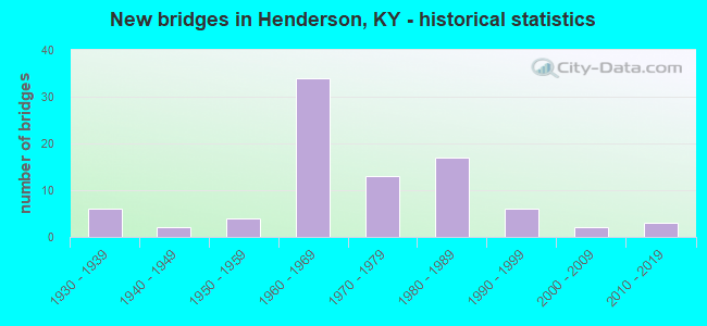
- New bridges - historical statistics
- 61930-1939
- 21940-1949
- 41950-1959
- 341960-1969
- 131970-1979
- 171980-1989
- 61990-1999
- 22000-2009
- 32010-2019
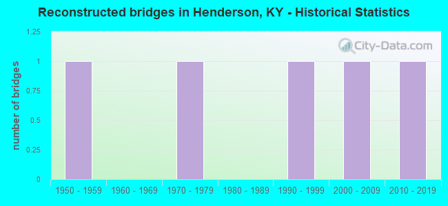
- Reconstructed bridges - Historical Statistics
- 11950-1959
- 01960-1969
- 11970-1979
- 01980-1989
- 11990-1999
- 12000-2009
- 12010-2019
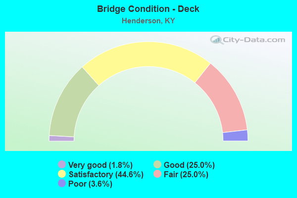
- Bridge Condition - Deck
- 1.8%Very good
- 25.0%Good
- 44.6%Satisfactory
- 25.0%Fair
- 3.6%Poor
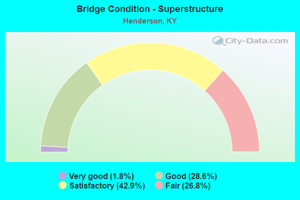
- Bridge Condition - Superstructure
- 1.8%Very good
- 28.6%Good
- 42.9%Satisfactory
- 26.8%Fair
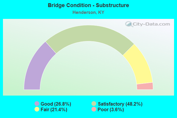
- Bridge Condition - Substructure
- 26.8%Good
- 48.2%Satisfactory
- 21.4%Fair
- 3.6%Poor
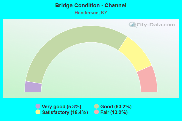
- Bridge Condition - Channel
- 5.3%Very good
- 63.2%Good
- 18.4%Satisfactory
- 13.2%Fair
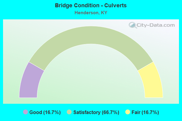
- Bridge Condition - Culverts
- 16.7%Good
- 66.7%Satisfactory
- 16.7%Fair
Find on map >> Show street view
Structure Number: 51B00002R, Location: NBL OHIO RIVER BRIDGE (Lat: 37.904444, Lng: -87.550833), Route carried "on" structure: US 41, Year Built: 1932, Year Reconstructed: 1957, Status: Posted for load, Structure Length: 164.46m (539.57ft), Average Daily Traffic: 18,012 (year 2020), Truck Traffic: 11%, Average Future Daily Traffic: 16,931 (year 2040), Design Load: HS 20, Features Intersected: OHIO RIVER
Minimum Vertical Clearance: 6.04m (19.82ft), Kilometerpoint: 31.514, Lanes on structure: 2, Lanes under structure: 2, Base Highway Network: Yes, Owner: State Highway Agency, Approaching Roadway Width: 11.6m (38.1ft), Navigation Control: Yes ( Vertical Clearance: 27.1m (88.9ft), Horizontal Clearance: 170.7m (560.0ft)), Material/Design: Steel, Design/Construction: Truss - Thru, Number Of Spans In Main Unit: 4, Number Of Approach Spans: 44, Length of Maximum Span: 219.5m (720.1ft), Curb-To-Curb Width: 9.1m (29.9ft), Out-to-Out Width: 10.1m (33.1ft)
Condition: Deck: Fair, Superstructure: Fair, Substructure: Fair, Operating Rating: 44.8 metric tons, Method Used To Determine Operating Rating: Load Factor (LF), Inventory Rating: 26.9 metric tons, Method Used To Determine Inventory Rating: Load Factor (LF), Structural Evaluation: Somewhat better than minimum adequacy, Deck Geometry: Meets minimum limits, Underclear: High priority of corrective action, Waterway Adequacy: Equal to present desirable criteria, Approach Roadway Alignment: Equal to present desirable criteria, Bridge Posting: Required (Relationship of Operating Rating to Maximum Legal Load: > 39.9% below), Designated Inspection Frequency: Every 24 months, Critical Feature Inspection Frequency: Every 24 months, Underwater Inspection Frequency: Every 60 months, Inspection Date: August 2020, Critical Feature Inspection Date: August 2020, Underwater Inspection Date: July 2021, Deck Structure Type: Concrete Cast-file-Place, Wearing Surface/Protective System: Wearing Surface: Monolithic Concrete, Deck Protection: Epoxy Coated Reinforcing
Find on map >> Show street view
Structure Number: 51B00007L, Location: SBL OHIO RIVER BRIDGE (Lat: 37.904444, Lng: -87.551389), Route carried "on" structure: US 41, Year Built: 1965, Status: Posted for load, Structure Length: 165.41m (542.68ft), Average Daily Traffic: 18,012 (year 2020), Truck Traffic: 11%, Average Future Daily Traffic: 16,931 (year 2040), Design Load: H 20, Features Intersected: OHIO RIVER
Minimum Vertical Clearance: 5.46m (17.91ft), Kilometerpoint: 31.521, Lanes on structure: 2, Lanes under structure: 2, Base Highway Network: Yes, Owner: State Highway Agency, Approaching Roadway Width: 14.6m (47.9ft), Navigation Control: Yes ( Vertical Clearance: 27.1m (88.9ft), Horizontal Clearance: 170.7m (560.0ft)), Material/Design: Steel, Design/Construction: Truss - Thru, Number Of Spans In Main Unit: 4, Number Of Approach Spans: 29, Length of Maximum Span: 219.5m (720.1ft), Curb or Sidewalk Widths: Left: 0.6m (2.0ft), Right: 0.6m (2.0ft), Curb-To-Curb Width: 9.1m (29.9ft), Out-to-Out Width: 9.8m (32.2ft)
Condition: Deck: Satisfactory, Superstructure: Fair, Substructure: Fair, Operating Rating: 42.6 metric tons, Method Used To Determine Operating Rating: Load Factor (LF), Inventory Rating: 25.6 metric tons, Method Used To Determine Inventory Rating: Load Factor (LF), Structural Evaluation: Somewhat better than minimum adequacy, Deck Geometry: Meets minimum limits, Underclear: High priority of corrective action, Waterway Adequacy: Equal to present desirable criteria, Approach Roadway Alignment: Equal to present desirable criteria, Bridge Posting: Required (Relationship of Operating Rating to Maximum Legal Load: 20.0 - 29.9% below), Designated Inspection Frequency: Every 24 months, Critical Feature Inspection Frequency: Every 24 months, Underwater Inspection Frequency: Every 60 months, Inspection Date: August 2020, Critical Feature Inspection Date: August 2020, Underwater Inspection Date: July 2021, Deck Structure Type: Concrete Cast-file-Place, Wearing Surface/Protective System: Wearing Surface: Latex Concrete
Find on map >> Show street view
Structure Number: 51B00010N, Location: OVER US 41 BY-PASS NTRCHN (Lat: 37.857222, Lng: -87.573333), Route carried "on" structure: US 60, Year Built: 1963, Status: Open, Structure Length: 7.13m (23.39ft), Average Daily Traffic: 22,806 (year 2020), Truck Traffic: 3%, Average Future Daily Traffic: 21,209 (year 2040), Design Load: HS 20, Features Intersected: US 41 BY PASS, Facility Carried by Structure: OWENSBORO ROAD
Minimum Vertical Clearance: 30+ m (98+ ft), Kilometerpoint: 16.562, Lanes on structure: 2, Lanes under structure: 4, Owner: State Highway Agency, Approaching Roadway Width: 17.7m (58.1ft), Skew: 20 degrees, Material/Design: Concrete continuous, Design/Construction: Tee Beam, Number Of Spans In Main Unit: 3, Length of Maximum Span: 30.5m (100.1ft), Curb or Sidewalk Widths: Left: 0.8m (2.6ft), Right: 0.8m (2.6ft), Curb-To-Curb Width: 17.7m (58.1ft), Out-to-Out Width: 19.8m (65.0ft)
Condition: Deck: Fair, Superstructure: Fair, Substructure: Fair, Operating Rating: 71.7 metric tons, Method Used To Determine Operating Rating: Allowable Stress (AS), Inventory Rating: 41.7 metric tons, Method Used To Determine Inventory Rating: Allowable Stress (AS), Structural Evaluation: Somewhat better than minimum adequacy, Deck Geometry: Superior to present desirable criteria, Underclear: Better than present minimum criteria, Approach Roadway Alignment: Equal to present desirable criteria, Length Of Structure Improvement: 0.71m (2.33ft), Designated Inspection Frequency: Every 24 months, Inspection Date: May 2020, Bridge Improvement Cost: $1,843,000, Total Project Cost: $1,842,000, Deck Structure Type: Concrete Cast-file-Place, Wearing Surface/Protective System: Wearing Surface: Latex Concrete
Find on map >> Show street view
Structure Number: 51B00011N, Location: OVR US41A NB RMP @US41NTR (Lat: 37.858056, Lng: -87.571944), Route carried "on" structure: US 60, Year Built: 1963, Status: Open, Structure Length: 4.85m (15.91ft), Average Daily Traffic: 22,806 (year 2020), Truck Traffic: 3%, Average Future Daily Traffic: 21,209 (year 2040), Design Load: HS 20, Features Intersected: US 41A, Facility Carried by Structure: OWENSBORO ROAD
Minimum Vertical Clearance: 30+ m (98+ ft), Kilometerpoint: 16.687, Lanes on structure: 2, Lanes under structure: 1, Owner: State Highway Agency, Approaching Roadway Width: 10.4m (34.1ft), Skew: 20 degrees, Material/Design: Concrete, Design/Construction: Tee Beam, Number Of Spans In Main Unit: 3, Length of Maximum Span: 15.2m (49.9ft), Curb or Sidewalk Widths: Left: 0.8m (2.6ft), Right: 0.8m (2.6ft), Curb-To-Curb Width: 10.4m (34.1ft), Out-to-Out Width: 12.5m (41.0ft)
Condition: Deck: Satisfactory, Superstructure: Fair, Substructure: Satisfactory, Operating Rating: 70.0 metric tons, Method Used To Determine Operating Rating: Load Factor (LF), Inventory Rating: 42.0 metric tons, Method Used To Determine Inventory Rating: Load Factor (LF), Structural Evaluation: Somewhat better than minimum adequacy, Deck Geometry: Meets minimum limits, Underclear: Somewhat better than minimum adequacy, Approach Roadway Alignment: Equal to present desirable criteria, Length Of Structure Improvement: 0.48m (1.57ft), Designated Inspection Frequency: Every 24 months, Inspection Date: May 2020, Bridge Improvement Cost: $930,000, Total Project Cost: $930,000, Deck Structure Type: Concrete Cast-file-Place, Wearing Surface/Protective System: Wearing Surface: Low Slump Concrete
Find on map >> Show street view
Structure Number: 51B00025N, Location: .2 MI S OF N JCT KY 136 (Lat: 37.795556, Lng: -87.570833), Route carried "on" structure: State highway 2084, Year Built: 1948, Status: Open, Structure Length: 4.39m (14.40ft), Average Daily Traffic: 5,974 (year 2020), Truck Traffic: 12%, Average Future Daily Traffic: 5,555 (year 2040), Design Load: HS 20, Features Intersected: ELAM DITCH, Facility Carried by Structure: MADISONVILLE ROAD
Minimum Vertical Clearance: 30+ m (98+ ft), Kilometerpoint: 0.647, Lanes on structure: 2, Owner: State Highway Agency, Approaching Roadway Width: 6.7m (22.0ft), Skew: 4 degrees, Material/Design: Concrete, Design/Construction: Tee Beam, Number Of Spans In Main Unit: 3, Length of Maximum Span: 13.7m (44.9ft), Curb or Sidewalk Widths: Left: 0.5m (1.6ft), Right: 0.5m (1.6ft), Curb-To-Curb Width: 7.9m (25.9ft), Out-to-Out Width: 9.7m (31.8ft)
Condition: Deck: Fair, Superstructure: Satisfactory, Substructure: Fair, Channel: Satisfactory, Operating Rating: 59.0 metric tons, Method Used To Determine Operating Rating: Load Factor (LF), Inventory Rating: 35.4 metric tons, Method Used To Determine Inventory Rating: Load Factor (LF), Structural Evaluation: Somewhat better than minimum adequacy, Deck Geometry: High priority of replacement, Waterway Adequacy: Better than present minimum criteria, Approach Roadway Alignment: Equal to present desirable criteria, Length Of Structure Improvement: 0.44m (1.44ft), Designated Inspection Frequency: Every 24 months, Inspection Date: May 2020, Bridge Improvement Cost: $522,000, Total Project Cost: $522,000, Deck Structure Type: Concrete Cast-file-Place, Wearing Surface/Protective System: Wearing Surface: Bituminous, Membrane: Preformed Fabric
Find on map >> Show street view
Structure Number: 51B00029N, Location: .50 MI SOU. OF JCT KY 136 (Lat: 37.808889, Lng: -87.587778), Route carried "on" structure: State highway 285, Year Built: 1963, Status: Open, Structure Length: 3.02m (9.91ft), Average Daily Traffic: 2,457 (year 2020), Truck Traffic: 5%, Average Future Daily Traffic: 2,285 (year 2040), Design Load: H 20, Features Intersected: CANOE CREEK, Facility Carried by Structure: OLD MADISONVILLE R
Minimum Vertical Clearance: 30+ m (98+ ft), Kilometerpoint: 3.378, Lanes on structure: 2, Owner: State Highway Agency, Approaching Roadway Width: 6.7m (22.0ft), Skew: 1 degrees, Material/Design: Concrete, Design/Construction: Tee Beam, Number Of Spans In Main Unit: 3, Length of Maximum Span: 9.1m (29.9ft), Curb or Sidewalk Widths: Left: 0.3m (1.0ft), Right: 0.3m (1.0ft), Curb-To-Curb Width: 8.5m (27.9ft), Out-to-Out Width: 9.8m (32.2ft)
Condition: Deck: Satisfactory, Superstructure: Satisfactory, Substructure: Fair, Channel: Good, Operating Rating: 74.9 metric tons, Method Used To Determine Operating Rating: Load Factor (LF), Inventory Rating: 44.9 metric tons, Method Used To Determine Inventory Rating: Load Factor (LF), Structural Evaluation: Somewhat better than minimum adequacy, Deck Geometry: Meets minimum limits, Waterway Adequacy: Better than present minimum criteria, Approach Roadway Alignment: Equal to present desirable criteria, Designated Inspection Frequency: Every 24 months, Inspection Date: May 2020, Deck Structure Type: Concrete Cast-file-Place, Wearing Surface/Protective System: Wearing Surface: Latex Concrete
Find on map >> Show street view
Structure Number: 51B00039N, Location: .2 MI W OF W-JCT KY 136 (Lat: 37.800556, Lng: -87.646111), Route carried "on" structure: US 60, Year Built: 1956, Year Reconstructed: 2009, Status: Open, Structure Length: 1.26m (4.13ft), Average Daily Traffic: 11,568 (year 2015), Truck Traffic: 8%, Average Future Daily Traffic: 10,873 (year 2035), Design Load: HS 20, Features Intersected: WASHBURN DITCH, Facility Carried by Structure: MORGANFIELD ROAD
Minimum Vertical Clearance: 30+ m (98+ ft), Kilometerpoint: 14.161, Lanes on structure: 4, Base Highway Network: Yes, Owner: State Highway Agency, Approaching Roadway Width: 20.8m (68.2ft), Skew: 4 degrees, Material/Design: Concrete, Design/Construction: Culvert, Number Of Spans In Main Unit: 2, Length of Maximum Span: 6.1m (20.0ft)
Condition: Channel: Good, Culverts: Good, Operating Rating: 61.4 metric tons, Method Used To Determine Operating Rating: Load Factor (LF), Inventory Rating: 36.9 metric tons, Method Used To Determine Inventory Rating: Load Factor (LF), Structural Evaluation: Better than present minimum criteria, Waterway Adequacy: Better than present minimum criteria, Approach Roadway Alignment: Equal to present desirable criteria, Designated Inspection Frequency: Every 24 months, Inspection Date: May 2020
Find on map >> Show street view
Structure Number: 51B00048N, Location: 1.2 MI N OF JCT KY 1539 (Lat: 37.849722, Lng: -87.567500), Route carried "on" structure: City street 1114, Year Built: 1963, Status: Open, Structure Length: 6.52m (21.39ft), Average Daily Traffic: 620 (year 2019), Average Future Daily Traffic: 576 (year 2039), Design Load: H 20, Features Intersected: HENDERSON BY-PASS, Facility Carried by Structure: KIMSEY LANE
Minimum Vertical Clearance: 30+ m (98+ ft), Kilometerpoint: 0.882, Lanes on structure: 2, Lanes under structure: 4, Owner: State Highway Agency, Approaching Roadway Width: 7.3m (24.0ft), Material/Design: Concrete, Design/Construction: Tee Beam, Number Of Spans In Main Unit: 4, Length of Maximum Span: 15.5m (50.9ft), Curb or Sidewalk Widths: Left: 0.8m (2.6ft), Right: 0.8m (2.6ft), Curb-To-Curb Width: 7.9m (25.9ft), Out-to-Out Width: 10.0m (32.8ft)
Condition: Deck: Satisfactory, Superstructure: Satisfactory, Substructure: Satisfactory, Operating Rating: 69.3 metric tons, Method Used To Determine Operating Rating: Load Factor (LF), Inventory Rating: 41.5 metric tons, Method Used To Determine Inventory Rating: Load Factor (LF), Structural Evaluation: Equal to present minimum criteria, Deck Geometry: Somewhat better than minimum adequacy, Underclear: Equal to present minimum criteria, Approach Roadway Alignment: Equal to present minimum criteria, Designated Inspection Frequency: Every 24 months, Inspection Date: May 2020, Deck Structure Type: Concrete Cast-file-Place, Wearing Surface/Protective System: Wearing Surface: Monolithic Concrete
Find on map >> Show street view
Structure Number: 51B00049L, Location: SBL 1 MI S OF US 60 NTRCH (Lat: 37.842222, Lng: -87.565556), Route carried "on" structure: US 41, Year Built: 1963, Status: Posted for load, Structure Length: 3.63m (11.91ft), Average Daily Traffic: 16,570 (year 2019), Truck Traffic: 11%, Average Future Daily Traffic: 18,393 (year 2039), Design Load: HS 20, Features Intersected: VAN WICK ROAD
Minimum Vertical Clearance: 30+ m (98+ ft), Kilometerpoint: 23.875, Lanes on structure: 2, Lanes under structure: 2, Base Highway Network: Yes, Owner: State Highway Agency, Approaching Roadway Width: 13.7m (44.9ft), Skew: 2 degrees, Material/Design: Concrete, Design/Construction: Tee Beam, Number Of Spans In Main Unit: 3, Length of Maximum Span: 12.2m (40.0ft), Curb-To-Curb Width: 14.0m (45.9ft), Out-to-Out Width: 14.9m (48.9ft)
Condition: Deck: Satisfactory, Superstructure: Satisfactory, Substructure: Satisfactory, Operating Rating: 53.3 metric tons, Method Used To Determine Operating Rating: Load Factor (LF), Inventory Rating: 31.9 metric tons, Method Used To Determine Inventory Rating: Load Factor (LF), Structural Evaluation: Equal to present minimum criteria, Deck Geometry: Superior to present desirable criteria, Underclear: Equal to present minimum criteria, Approach Roadway Alignment: Equal to present desirable criteria, Bridge Posting: Required (Relationship of Operating Rating to Maximum Legal Load: 20.0 - 29.9% below), Length Of Structure Improvement: 0.36m (1.18ft), Designated Inspection Frequency: Every 24 months, Inspection Date: May 2020, Bridge Improvement Cost: $729,000, Total Project Cost: $728,000, Deck Structure Type: Concrete Cast-file-Place, Wearing Surface/Protective System: Wearing Surface: Integral Concrete, Deck Protection: Epoxy Coated Reinforcing
Find on map >> Show street view
Structure Number: 51B00049R, Location: NBL 1 MI S OF US 60 NTRCH (Lat: 37.842500, Lng: -87.565278), Route carried "on" structure: US 41, Year Built: 1968, Status: Posted for load, Structure Length: 3.63m (11.91ft), Average Daily Traffic: 16,570 (year 2019), Truck Traffic: 11%, Average Future Daily Traffic: 18,393 (year 2039), Design Load: HS 20, Features Intersected: VAN WICK ROAD
Minimum Vertical Clearance: 30+ m (98+ ft), Kilometerpoint: 23.912, Lanes on structure: 2, Lanes under structure: 1, Base Highway Network: Yes, Owner: State Highway Agency, Approaching Roadway Width: 11.6m (38.1ft), Skew: 2 degrees, Material/Design: Concrete, Design/Construction: Tee Beam, Number Of Spans In Main Unit: 3, Length of Maximum Span: 12.2m (40.0ft), Curb-To-Curb Width: 14.0m (45.9ft), Out-to-Out Width: 14.9m (48.9ft)
Condition: Deck: Satisfactory, Superstructure: Good, Substructure: Satisfactory, Operating Rating: 53.3 metric tons, Method Used To Determine Operating Rating: Load Factor (LF), Inventory Rating: 31.9 metric tons, Method Used To Determine Inventory Rating: Load Factor (LF), Structural Evaluation: Equal to present minimum criteria, Deck Geometry: Superior to present desirable criteria, Underclear: Equal to present minimum criteria, Approach Roadway Alignment: Equal to present desirable criteria, Bridge Posting: Required (Relationship of Operating Rating to Maximum Legal Load: 20.0 - 29.9% below), Length Of Structure Improvement: 0.36m (1.18ft), Designated Inspection Frequency: Every 24 months, Inspection Date: May 2020, Bridge Improvement Cost: $729,000, Total Project Cost: $728,000, Deck Structure Type: Concrete Cast-file-Place, Wearing Surface/Protective System: Wearing Surface: Integral Concrete, Deck Protection: Epoxy Coated Reinforcing
Find on map >> Show street view
Structure Number: 51B00050L, Location: SBL OVER KY 351 INTRCHNGE (Lat: 37.830556, Lng: -87.566389), Route carried "on" structure: US 41, Year Built: 1963, Year Reconstructed: 2004, Status: Open, Structure Length: 4.85m (15.91ft), Average Daily Traffic: 16,570 (year 2019), Truck Traffic: 11%, Average Future Daily Traffic: 18,393 (year 2039), Design Load: HS 20, Features Intersected: KY 351
Minimum Vertical Clearance: 30+ m (98+ ft), Kilometerpoint: 22.557, Lanes on structure: 2, Lanes under structure: 4, Base Highway Network: Yes, Owner: State Highway Agency, Approaching Roadway Width: 11.3m (37.1ft), Skew: 10 degrees, Material/Design: Concrete, Design/Construction: Tee Beam, Number Of Spans In Main Unit: 3, Length of Maximum Span: 15.2m (49.9ft), Curb-To-Curb Width: 10.4m (34.1ft), Out-to-Out Width: 11.3m (37.1ft)
Condition: Deck: Good, Superstructure: Satisfactory, Substructure: Satisfactory, Operating Rating: 62.0 metric tons, Method Used To Determine Operating Rating: Load Factor (LF), Inventory Rating: 37.2 metric tons, Method Used To Determine Inventory Rating: Load Factor (LF), Structural Evaluation: Equal to present minimum criteria, Deck Geometry: Meets minimum limits, Underclear: Somewhat better than minimum adequacy, Approach Roadway Alignment: Equal to present desirable criteria, Length Of Structure Improvement: 0.48m (1.57ft), Designated Inspection Frequency: Every 24 months, Inspection Date: May 2020, Bridge Improvement Cost: $735,000, Total Project Cost: $735,000, Deck Structure Type: Concrete Cast-file-Place, Wearing Surface/Protective System: Wearing Surface: Integral Concrete, Deck Protection: Epoxy Coated Reinforcing
Find on map >> Show street view
Structure Number: 51B00050R, Location: NBL OVER KY 351 INTRCHNGE (Lat: 37.830556, Lng: -87.566389), Route carried "on" structure: US 41, Year Built: 1963, Status: Open, Structure Length: 4.85m (15.91ft), Average Daily Traffic: 16,570 (year 2019), Truck Traffic: 11%, Average Future Daily Traffic: 18,393 (year 2039), Design Load: HS 20, Features Intersected: KY 351
Minimum Vertical Clearance: 30+ m (98+ ft), Kilometerpoint: 22.582, Lanes on structure: 2, Lanes under structure: 4, Base Highway Network: Yes, Owner: State Highway Agency, Approaching Roadway Width: 11.0m (36.1ft), Skew: 10 degrees, Material/Design: Concrete, Design/Construction: Tee Beam, Number Of Spans In Main Unit: 3, Length of Maximum Span: 15.2m (49.9ft), Curb-To-Curb Width: 10.3m (33.8ft), Out-to-Out Width: 11.3m (37.1ft)
Condition: Deck: Satisfactory, Superstructure: Fair, Substructure: Satisfactory, Operating Rating: 62.0 metric tons, Method Used To Determine Operating Rating: Load Factor (LF), Inventory Rating: 37.2 metric tons, Method Used To Determine Inventory Rating: Load Factor (LF), Structural Evaluation: Somewhat better than minimum adequacy, Deck Geometry: High priority of corrective action, Underclear: Somewhat better than minimum adequacy, Approach Roadway Alignment: Equal to present desirable criteria, Length Of Structure Improvement: 0.48m (1.57ft), Designated Inspection Frequency: Every 24 months, Inspection Date: May 2020, Bridge Improvement Cost: $735,000, Total Project Cost: $735,000, Deck Structure Type: Concrete Cast-file-Place, Wearing Surface/Protective System: Wearing Surface: Integral Concrete, Deck Protection: Epoxy Coated Reinforcing
Find on map >> Show street view
Structure Number: 51B00051L, Location: SBL 1 MI S OF US 60 OP (Lat: 37.839722, Lng: -87.565000), Route carried "on" structure: US 41, Year Built: 1963, Status: Open, Structure Length: 6.31m (20.70ft), Average Daily Traffic: 16,570 (year 2019), Truck Traffic: 11%, Average Future Daily Traffic: 18,393 (year 2039), Design Load: HS 20, Features Intersected: CSX RAILROAD
Minimum Vertical Clearance: 30+ m (98+ ft), Kilometerpoint: 23.570, Lanes on structure: 2, Base Highway Network: Yes, Owner: State Highway Agency, Approaching Roadway Width: 11.6m (38.1ft), Skew: 12 degrees, Material/Design: Concrete continuous, Design/Construction: Tee Beam, Number Of Spans In Main Unit: 3, Length of Maximum Span: 24.4m (80.1ft), Curb-To-Curb Width: 10.4m (34.1ft), Out-to-Out Width: 11.3m (37.1ft)
Condition: Deck: Satisfactory, Superstructure: Fair, Substructure: Satisfactory, Operating Rating: 48.4 metric tons, Method Used To Determine Operating Rating: Load Factor (LF), Inventory Rating: 29.0 metric tons, Method Used To Determine Inventory Rating: Load Factor (LF), Structural Evaluation: Somewhat better than minimum adequacy, Deck Geometry: Meets minimum limits, Underclear: Better than present minimum criteria, Approach Roadway Alignment: Equal to present desirable criteria, Designated Inspection Frequency: Every 24 months, Inspection Date: May 2020, Bridge Improvement Cost: $260,000, Total Project Cost: $260,000, Deck Structure Type: Concrete Cast-file-Place, Wearing Surface/Protective System: Wearing Surface: Integral Concrete, Deck Protection: Epoxy Coated Reinforcing
Find on map >> Show street view
Structure Number: 51B00051R, Location: NBL .9 MI S OF US 60 OP (Lat: 37.839722, Lng: -87.564722), Route carried "on" structure: US 41, Year Built: 1968, Status: Open, Structure Length: 6.31m (20.70ft), Average Daily Traffic: 16,570 (year 2019), Truck Traffic: 11%, Average Future Daily Traffic: 18,393 (year 2039), Design Load: HS 20, Features Intersected: CSX RAILROAD
Minimum Vertical Clearance: 30+ m (98+ ft), Kilometerpoint: 23.607, Lanes on structure: 2, Base Highway Network: Yes, Owner: State Highway Agency, Approaching Roadway Width: 11.6m (38.1ft), Skew: 12 degrees, Material/Design: Concrete continuous, Design/Construction: Tee Beam, Number Of Spans In Main Unit: 3, Length of Maximum Span: 24.4m (80.1ft), Curb-To-Curb Width: 10.4m (34.1ft), Out-to-Out Width: 11.3m (37.1ft)
Condition: Deck: Satisfactory, Superstructure: Fair, Substructure: Satisfactory, Operating Rating: 48.4 metric tons, Method Used To Determine Operating Rating: Load Factor (LF), Inventory Rating: 29.0 metric tons, Method Used To Determine Inventory Rating: Load Factor (LF), Structural Evaluation: Somewhat better than minimum adequacy, Deck Geometry: Meets minimum limits, Underclear: Better than present minimum criteria, Approach Roadway Alignment: Equal to present desirable criteria, Designated Inspection Frequency: Every 24 months, Inspection Date: May 2020, Deck Structure Type: Concrete Cast-file-Place, Wearing Surface/Protective System: Wearing Surface: Integral Concrete, Deck Protection: Epoxy Coated Reinforcing
Find on map >> Show street view
Structure Number: 51B00052N, Location: .40 MI SOU. OF JCT KY 812 (Lat: 37.814444, Lng: -87.570833), Route carried "on" structure: State highway 2084, Year Built: 1948, Status: Open, Structure Length: 2.56m (8.40ft), Average Daily Traffic: 6,231 (year 2019), Truck Traffic: 12%, Average Future Daily Traffic: 5,794 (year 2039), Design Load: HS 20, Features Intersected: BR CANOE CRK, Facility Carried by Structure: MADISONVILLE ROAD
Minimum Vertical Clearance: 30+ m (98+ ft), Kilometerpoint: 2.784, Lanes on structure: 2, Owner: State Highway Agency, Approaching Roadway Width: 6.7m (22.0ft), Skew: 2 degrees, Material/Design: Concrete, Design/Construction: Tee Beam, Number Of Spans In Main Unit: 3, Length of Maximum Span: 7.6m (24.9ft), Curb or Sidewalk Widths: Left: 0.5m (1.6ft), Right: 0.5m (1.6ft), Curb-To-Curb Width: 7.9m (25.9ft), Out-to-Out Width: 9.5m (31.2ft)
Condition: Deck: Poor, Superstructure: Satisfactory, Substructure: Fair, Channel: Satisfactory, Operating Rating: 68.2 metric tons, Method Used To Determine Operating Rating: Load Factor (LF), Inventory Rating: 40.9 metric tons, Method Used To Determine Inventory Rating: Load Factor (LF), Structural Evaluation: Somewhat better than minimum adequacy, Deck Geometry: High priority of replacement, Waterway Adequacy: Better than present minimum criteria, Approach Roadway Alignment: Equal to present desirable criteria, Length Of Structure Improvement: 0.26m (0.85ft), Designated Inspection Frequency: Every 24 months, Inspection Date: May 2020, Bridge Improvement Cost: $304,000, Total Project Cost: $304,000, Deck Structure Type: Concrete Cast-file-Place, Wearing Surface/Protective System: Wearing Surface: Low Slump Concrete
Find on map >> Show street view
Structure Number: 51B00053L, Location: SBL .8 MI S OF US 60 OP (Lat: 37.844722, Lng: -87.566111), Route carried "on" structure: US 41, Year Built: 1963, Status: Posted for load, Structure Length: 3.47m (11.38ft), Average Daily Traffic: 16,570 (year 2019), Truck Traffic: 11%, Average Future Daily Traffic: 18,393 (year 2039), Design Load: HS 20, Features Intersected: CANOE CREEK
Minimum Vertical Clearance: 30+ m (98+ ft), Kilometerpoint: 24.135, Lanes on structure: 2, Base Highway Network: Yes, Owner: State Highway Agency, Approaching Roadway Width: 11.6m (38.1ft), Skew: 13 degrees, Material/Design: Concrete, Design/Construction: Tee Beam, Number Of Spans In Main Unit: 3, Length of Maximum Span: 10.7m (35.1ft), Curb-To-Curb Width: 14.0m (45.9ft), Out-to-Out Width: 14.9m (48.9ft)
Condition: Deck: Satisfactory, Superstructure: Satisfactory, Substructure: Satisfactory, Channel: Good, Operating Rating: 57.2 metric tons, Method Used To Determine Operating Rating: Load Factor (LF), Inventory Rating: 34.3 metric tons, Method Used To Determine Inventory Rating: Load Factor (LF), Structural Evaluation: Equal to present minimum criteria, Deck Geometry: Superior to present desirable criteria, Waterway Adequacy: Equal to present desirable criteria, Approach Roadway Alignment: Equal to present desirable criteria, Bridge Posting: Required (Relationship of Operating Rating to Maximum Legal Load: 20.0 - 29.9% below), Designated Inspection Frequency: Every 24 months, Inspection Date: May 2020, Deck Structure Type: Concrete Cast-file-Place, Wearing Surface/Protective System: Wearing Surface: Integral Concrete, Deck Protection: Epoxy Coated Reinforcing
Find on map >> Show street view
Structure Number: 51B00053R, Location: NBL .8 MI S OF US 60 OP (Lat: 37.844722, Lng: -87.565833), Route carried "on" structure: US 41, Year Built: 1968, Status: Posted for load, Structure Length: 3.47m (11.38ft), Average Daily Traffic: 16,570 (year 2019), Truck Traffic: 11%, Average Future Daily Traffic: 18,393 (year 2039), Design Load: HS 20, Features Intersected: CANOE CREEK
Minimum Vertical Clearance: 30+ m (98+ ft), Kilometerpoint: 24.172, Lanes on structure: 2, Base Highway Network: Yes, Owner: State Highway Agency, Approaching Roadway Width: 11.6m (38.1ft), Skew: 13 degrees, Material/Design: Concrete, Design/Construction: Tee Beam, Number Of Spans In Main Unit: 3, Length of Maximum Span: 10.7m (35.1ft), Curb-To-Curb Width: 14.0m (45.9ft), Out-to-Out Width: 14.9m (48.9ft)
Condition: Deck: Good, Superstructure: Good, Substructure: Good, Channel: Satisfactory, Operating Rating: 57.2 metric tons, Method Used To Determine Operating Rating: Load Factor (LF), Inventory Rating: 34.3 metric tons, Method Used To Determine Inventory Rating: Load Factor (LF), Structural Evaluation: Better than present minimum criteria, Deck Geometry: Superior to present desirable criteria, Waterway Adequacy: Equal to present desirable criteria, Approach Roadway Alignment: Equal to present desirable criteria, Bridge Posting: Required (Relationship of Operating Rating to Maximum Legal Load: 20.0 - 29.9% below), Designated Inspection Frequency: Every 24 months, Inspection Date: May 2020, Deck Structure Type: Concrete Cast-file-Place, Wearing Surface/Protective System: Wearing Surface: Integral Concrete, Deck Protection: Epoxy Coated Reinforcing
Find on map >> Show street view
Structure Number: 51B00061N, Location: .20 MI NOR. OF AUDUBON PW (Lat: 37.814444, Lng: -87.563333), Route carried "on" structure: US 41, Year Built: 1968, Year Reconstructed: 1970, Status: Open, Structure Length: 0.85m (2.79ft), Average Daily Traffic: 20,747 (year 2017), Average Future Daily Traffic: 23,029 (year 2037), Design Load: HS 20, Features Intersected: BR OF CANOE CRK, Facility Carried by Structure: EB-9004
Minimum Vertical Clearance: 30+ m (98+ ft), Kilometerpoint: 20.688, Lanes on structure: 4, Base Highway Network: Yes, Owner: State Highway Agency, Approaching Roadway Width: 23.2m (76.1ft), Skew: 2 degrees, Material/Design: Concrete, Design/Construction: Culvert, Number Of Spans In Main Unit: 2, Length of Maximum Span: 4.0m (13.1ft)
Condition: Channel: Fair, Culverts: Satisfactory, Inventory Rating: 78.0 metric tons, Method Used To Determine Inventory Rating: Load Factor (LF), Structural Evaluation: Equal to present minimum criteria, Waterway Adequacy: Better than present minimum criteria, Approach Roadway Alignment: Equal to present desirable criteria, Designated Inspection Frequency: Every 24 months, Inspection Date: May 2020
Find on map >> Show street view
Structure Number: 51B00068L, Location: SBL .9 M S OF KY 425 NTRC (Lat: 37.786389, Lng: -87.549444), Route carried "on" structure: Interstate 69, Year Built: 1968, Status: Open, Structure Length: 4.30m (14.11ft), Average Daily Traffic: 6,341 (year 2020), Truck Traffic: 30%, Average Future Daily Traffic: 7,736 (year 2040), Design Load: HS 20, Features Intersected: ELAM DITCH, Facility Carried by Structure: EDWARD T BREATHITT
Minimum Vertical Clearance: 30+ m (98+ ft), Kilometerpoint: 236.942, Lanes on structure: 2, Base Highway Network: Yes, Owner: State Highway Agency, Approaching Roadway Width: 11.6m (38.1ft), Skew: 22 degrees, Material/Design: Prestressed concrete continuous, Design/Construction: Stringer/Multi-beam, Number Of Spans In Main Unit: 3, Length of Maximum Span: 14.6m (47.9ft), Curb-To-Curb Width: 11.5m (37.7ft), Out-to-Out Width: 12.5m (41.0ft)
Condition: Deck: Fair, Superstructure: Satisfactory, Substructure: Satisfactory, Channel: Good, Operating Rating: 85.5 metric tons, Method Used To Determine Operating Rating: Load Factor (LF), Inventory Rating: 51.3 metric tons, Method Used To Determine Inventory Rating: Load Factor (LF), Structural Evaluation: Equal to present minimum criteria, Deck Geometry: Somewhat better than minimum adequacy, Waterway Adequacy: Better than present minimum criteria, Approach Roadway Alignment: Equal to present desirable criteria, Designated Inspection Frequency: Every 24 months, Inspection Date: May 2020, Deck Structure Type: Concrete Cast-file-Place, Wearing Surface/Protective System: Wearing Surface: Integral Concrete, Deck Protection: Epoxy Coated Reinforcing
Find on map >> Show street view
Structure Number: 51B00068R, Location: NBL .9 M S OF KY 425 NTRC (Lat: 37.786389, Lng: -87.549167), Route carried "on" structure: Interstate 69, Year Built: 1968, Status: Open, Structure Length: 4.30m (14.11ft), Average Daily Traffic: 6,341 (year 2020), Truck Traffic: 30%, Average Future Daily Traffic: 7,736 (year 2040), Design Load: HS 20, Features Intersected: ELAM DITCH, Facility Carried by Structure: EB-9004
Minimum Vertical Clearance: 30+ m (98+ ft), Kilometerpoint: 236.929, Lanes on structure: 2, Base Highway Network: Yes, Owner: State Highway Agency, Approaching Roadway Width: 11.6m (38.1ft), Skew: 22 degrees, Material/Design: Prestressed concrete continuous, Design/Construction: Stringer/Multi-beam, Number Of Spans In Main Unit: 3, Length of Maximum Span: 14.6m (47.9ft), Curb-To-Curb Width: 11.5m (37.7ft), Out-to-Out Width: 12.5m (41.0ft)
Condition: Deck: Fair, Superstructure: Satisfactory, Substructure: Good, Channel: Good, Operating Rating: 85.5 metric tons, Method Used To Determine Operating Rating: Load Factor (LF), Inventory Rating: 51.3 metric tons, Method Used To Determine Inventory Rating: Load Factor (LF), Structural Evaluation: Equal to present minimum criteria, Deck Geometry: Somewhat better than minimum adequacy, Waterway Adequacy: Better than present minimum criteria, Approach Roadway Alignment: Equal to present desirable criteria, Designated Inspection Frequency: Every 24 months, Inspection Date: May 2020, Deck Structure Type: Concrete Cast-file-Place, Wearing Surface/Protective System: Wearing Surface: Integral Concrete, Deck Protection: Epoxy Coated Reinforcing
Find on map >> Show street view
Structure Number: 51B00069N, Location: .4 MI E OF JCT US 41 (Lat: 37.805278, Lng: -87.563889), Route carried "on" structure: State highway 2099, Year Built: 1968, Status: Open, Structure Length: 7.10m (23.29ft), Average Daily Traffic: 552 (year 2015), Average Future Daily Traffic: 513 (year 2035), Design Load: H 20, Features Intersected: I 69, Facility Carried by Structure: ADAMS LANE #1
Minimum Vertical Clearance: 30+ m (98+ ft), Kilometerpoint: 0.750, Lanes on structure: 2, Lanes under structure: 4, Owner: State Highway Agency, Approaching Roadway Width: 5.8m (19.0ft), Skew: 23 degrees, Material/Design: Concrete continuous, Design/Construction: Box Beam or Girders - Single/Spread, Number Of Spans In Main Unit: 2, Length of Maximum Span: 28.0m (91.9ft), Curb or Sidewalk Widths: Left: 0.5m (1.6ft), Right: 0.5m (1.6ft), Curb-To-Curb Width: 7.9m (25.9ft), Out-to-Out Width: 8.8m (28.9ft)
Condition: Deck: Fair, Superstructure: Fair, Substructure: Satisfactory, Operating Rating: 86.4 metric tons, Method Used To Determine Operating Rating: Load Factor (LF), Inventory Rating: 51.8 metric tons, Method Used To Determine Inventory Rating: Load Factor (LF), Structural Evaluation: Somewhat better than minimum adequacy, Deck Geometry: Somewhat better than minimum adequacy, Underclear: Somewhat better than minimum adequacy, Approach Roadway Alignment: Equal to present desirable criteria, Designated Inspection Frequency: Every 24 months, Inspection Date: May 2020, Deck Structure Type: Concrete Cast-file-Place, Wearing Surface/Protective System: Wearing Surface: Monolithic Concrete
Find on map >> Show street view
Structure Number: 51B00073L, Location: OVER PENNYRILE PW NTRCHG (Lat: 37.810000, Lng: -87.563889), Route carried "on" structure: State highway 9005, Year Built: 1970, Status: Open, Structure Length: 5.82m (19.09ft), Average Daily Traffic: 4,838 (year 2019), Truck Traffic: 22%, Average Future Daily Traffic: 4,548 (year 2039), Design Load: HS 20, Features Intersected: PENNYRILE PKWY, Facility Carried by Structure: AUDUBON PKY NC
Minimum Vertical Clearance: 30+ m (98+ ft), Kilometerpoint: 0.008, Lanes on structure: 2, Lanes under structure: 4, Base Highway Network: Yes, Owner: State Highway Agency, Approaching Roadway Width: 7.9m (25.9ft), Skew: 10 degrees, Material/Design: Steel continuous, Design/Construction: Stringer/Multi-beam, Number Of Spans In Main Unit: 2, Length of Maximum Span: 28.3m (92.8ft), Curb or Sidewalk Widths: Left: 0.2m (0.7ft), Right: 0.2m (0.7ft), Curb-To-Curb Width: 7.9m (25.9ft), Out-to-Out Width: 9.0m (29.5ft)
Condition: Deck: Good, Superstructure: Good, Substructure: Good, Operating Rating: 67.7 metric tons, Method Used To Determine Operating Rating: Load Factor (LF), Inventory Rating: 40.6 metric tons, Method Used To Determine Inventory Rating: Load Factor (LF), Structural Evaluation: Better than present minimum criteria, Deck Geometry: High priority of replacement, Underclear: Somewhat better than minimum adequacy, Approach Roadway Alignment: Better than present minimum criteria, Length Of Structure Improvement: 0.58m (1.90ft), Designated Inspection Frequency: Every 24 months, Inspection Date: May 2020, Bridge Improvement Cost: $657,000, Total Project Cost: $656,000, Deck Structure Type: Concrete Cast-file-Place, Wearing Surface/Protective System: Wearing Surface: Latex Concrete
Find on map >> Show street view
Structure Number: 51B00073R, Location: OVER PENNYRILE PW NTRCHG (Lat: 37.809722, Lng: -87.563611), Route carried "on" structure: State highway 9005, Year Built: 1970, Status: Open, Structure Length: 5.82m (19.09ft), Average Daily Traffic: 4,838 (year 2019), Truck Traffic: 22%, Average Future Daily Traffic: 4,548 (year 2039), Design Load: HS 20, Features Intersected: US 41
Minimum Vertical Clearance: 30+ m (98+ ft), Kilometerpoint: 0.008, Lanes on structure: 2, Lanes under structure: 4, Base Highway Network: Yes, Owner: State Highway Agency, Approaching Roadway Width: 7.9m (25.9ft), Skew: 20 degrees, Material/Design: Steel continuous, Design/Construction: Stringer/Multi-beam, Number Of Spans In Main Unit: 2, Length of Maximum Span: 28.3m (92.8ft), Curb or Sidewalk Widths: Left: 0.2m (0.7ft), Right: 0.2m (0.7ft), Curb-To-Curb Width: 7.9m (25.9ft), Out-to-Out Width: 9.0m (29.5ft)
Condition: Deck: Good, Superstructure: Good, Substructure: Satisfactory, Operating Rating: 67.7 metric tons, Method Used To Determine Operating Rating: Load Factor (LF), Inventory Rating: 40.6 metric tons, Method Used To Determine Inventory Rating: Load Factor (LF), Structural Evaluation: Equal to present minimum criteria, Deck Geometry: High priority of replacement, Underclear: Meets minimum limits, Approach Roadway Alignment: Better than present minimum criteria, Length Of Structure Improvement: 0.58m (1.90ft), Designated Inspection Frequency: Every 24 months, Inspection Date: May 2020, Bridge Improvement Cost: $657,000, Total Project Cost: $656,000, Deck Structure Type: Concrete Cast-file-Place, Wearing Surface/Protective System: Wearing Surface: Latex Concrete
Find on map >> Show street view
Structure Number: 51B00074N, Location: 1.2 MI SE OF JCT US 41 (Lat: 37.810278, Lng: -87.552500), Route carried "on" structure: State highway 812, Year Built: 1970, Status: Open, Structure Length: 8.23m (27.00ft), Average Daily Traffic: 4,130 (year 2017), Truck Traffic: 7%, Average Future Daily Traffic: 3,840 (year 2037), Design Load: H 20, Features Intersected: AUDUBON PKWY
Minimum Vertical Clearance: 30+ m (98+ ft), Kilometerpoint: 10.057, Lanes on structure: 2, Lanes under structure: 4, Owner: State Highway Agency, Approaching Roadway Width: 6.7m (22.0ft), Skew: 24 degrees, Material/Design: Steel continuous, Design/Construction: Stringer/Multi-beam, Number Of Spans In Main Unit: 2, Length of Maximum Span: 39.9m (130.9ft), Curb or Sidewalk Widths: Left: 0.2m (0.7ft), Right: 0.2m (0.7ft), Curb-To-Curb Width: 10.4m (34.1ft), Out-to-Out Width: 11.4m (37.4ft)
Condition: Deck: Good, Superstructure: Good, Substructure: Good, Operating Rating: 63.6 metric tons, Method Used To Determine Operating Rating: Load Factor (LF), Inventory Rating: 38.1 metric tons, Method Used To Determine Inventory Rating: Load Factor (LF), Structural Evaluation: Better than present minimum criteria, Deck Geometry: Somewhat better than minimum adequacy, Underclear: Better than present minimum criteria, Approach Roadway Alignment: Equal to present desirable criteria, Designated Inspection Frequency: Every 24 months, Inspection Date: April 2020, Deck Structure Type: Concrete Cast-file-Place, Wearing Surface/Protective System: Wearing Surface: Monolithic Concrete
Find on map >> Show street view
Structure Number: 51B00087N, Location: 2 MI SE OF AUDBN PW OP (Lat: 37.793056, Lng: -87.523056), Route carried "on" structure: State highway 812, Year Built: 1965, Year Reconstructed: 2017, Status: Open, Structure Length: 1.62m (5.31ft), Average Daily Traffic: 935 (year 2018), Average Future Daily Traffic: 822 (year 2038), Design Load: Greater than HL93, Features Intersected: BR OF ELAM DITCH
Minimum Vertical Clearance: 30+ m (98+ ft), Kilometerpoint: 6.827, Lanes on structure: 2, Owner: State Highway Agency, Approaching Roadway Width: 6.4m (21.0ft), Material/Design: Prestressed concrete, Design/Construction: Box Beam or Girders - Multiple, Number Of Spans In Main Unit: 1, Length of Maximum Span: 14.8m (48.6ft), Curb-To-Curb Width: 6.9m (22.6ft), Out-to-Out Width: 7.3m (24.0ft)
Condition: Deck: Satisfactory, Superstructure: Good, Substructure: Good, Channel: Good, Operating Rating: 86.8 metric tons, Method Used To Determine Operating Rating: Load and Resistance Factor Rating (LRFR) rating reported by rating factor(RF) method using HL-93 loadings, Inventory Rating: 67.1 metric tons, Method Used To Determine Inventory Rating: Load and Resistance Factor Rating (LRFR) rating reported by rating factor(RF) method using HL-93 loadings, Structural Evaluation: Better than present minimum criteria, Deck Geometry: Meets minimum limits, Waterway Adequacy: Meets minimum limits, Approach Roadway Alignment: Equal to present desirable criteria, Designated Inspection Frequency: Every 24 months, Inspection Date: April 2020, Deck Structure Type: Concrete Precast Panels, Wearing Surface/Protective System: Wearing Surface: Monolithic Concrete, Deck Protection: Epoxy Coated Reinforcing
Find on map >> Show street view
Structure Number: 51B00093N, Location: .23 MI WEST OF JCT US 41 (Lat: 37.825278, Lng: -87.572222), Route carried "on" structure: State highway 2098, Year Built: 1952, Status: Posted for load, Structure Length: 3.02m (9.91ft), Average Daily Traffic: 1,397 (year 2015), Truck Traffic: 7%, Average Future Daily Traffic: 1,299 (year 2035), Design Load: H 15, Features Intersected: CANOE CREEK, Facility Carried by Structure: WASHINGTON STREET
Minimum Vertical Clearance: 30+ m (98+ ft), Kilometerpoint: 0.077, Lanes on structure: 2, Owner: State Highway Agency, Approaching Roadway Width: 6.1m (20.0ft), Skew: 3 degrees, Material/Design: Concrete, Design/Construction: Tee Beam, Number Of Spans In Main Unit: 3, Length of Maximum Span: 9.1m (29.9ft), Curb or Sidewalk Widths: Left: 0.8m (2.6ft), Right: 0.8m (2.6ft), Curb-To-Curb Width: 6.7m (22.0ft), Out-to-Out Width: 9.0m (29.5ft)
Condition: Deck: Fair, Superstructure: Good, Substructure: Poor, Channel: Good, Operating Rating: 40.1 metric tons, Method Used To Determine Operating Rating: Load Factor (LF), Inventory Rating: 24.0 metric tons, Method Used To Determine Inventory Rating: Load Factor (LF), Structural Evaluation: Meets minimum limits, Deck Geometry: High priority of corrective action, Waterway Adequacy: Better than present minimum criteria, Approach Roadway Alignment: Equal to present desirable criteria, Bridge Posting: Required (Relationship of Operating Rating to Maximum Legal Load: > 39.9% below), Length Of Structure Improvement: 0.30m (0.98ft), Designated Inspection Frequency: Every 24 months, Inspection Date: May 2020, Bridge Improvement Cost: $339,000, Total Project Cost: $339,000, Deck Structure Type: Concrete Cast-file-Place, Wearing Surface/Protective System: Wearing Surface: Monolithic Concrete
Find on map >> Show street view
Structure Number: 51B00095N, Location: .5 MI SE OF JCT KY 1217 (Lat: 37.760000, Lng: -87.585000), Route carried "on" structure: State highway 1299, Year Built: 1967, Status: Open, Structure Length: 1.62m (5.31ft), Average Daily Traffic: 181 (year 2020), Average Future Daily Traffic: 159 (year 2040), Design Load: HS 20, Features Intersected: W FK CANOE CREEK DITCH
Minimum Vertical Clearance: 30+ m (98+ ft), Kilometerpoint: 11.084, Lanes on structure: 2, Owner: State Highway Agency, Approaching Roadway Width: 5.5m (18.0ft), Material/Design: Prestressed concrete, Design/Construction: Box Beam or Girders - Multiple, Number Of Spans In Main Unit: 1, Length of Maximum Span: 15.2m (49.9ft), Curb or Sidewalk Widths: Left: 0.1m (0.3ft), Right: 0.1m (0.3ft), Curb-To-Curb Width: 6.9m (22.6ft), Out-to-Out Width: 7.5m (24.6ft)
Condition: Deck: Fair, Superstructure: Fair, Substructure: Fair, Channel: Fair, Operating Rating: 72.7 metric tons, Method Used To Determine Operating Rating: Load Factor (LF), Inventory Rating: 43.6 metric tons, Method Used To Determine Inventory Rating: Load Factor (LF), Structural Evaluation: Somewhat better than minimum adequacy, Deck Geometry: Meets minimum limits, Waterway Adequacy: Meets minimum limits, Approach Roadway Alignment: Equal to present minimum criteria, Designated Inspection Frequency: Every 24 months, Inspection Date: May 2020, Deck Structure Type: Concrete Precast Panels, Wearing Surface/Protective System: Wearing Surface: Bituminous, Membrane: Preformed Fabric
Find on map >> Show street view
Structure Number: 51B00100N, Location: .9 MI SW OF JCT KY 1299 (Lat: 37.756111, Lng: -87.604167), Route carried "on" structure: State highway 1217, Year Built: 1955, Status: Posted for load, Structure Length: 1.40m (4.59ft), Average Daily Traffic: 379 (year 2020), Average Future Daily Traffic: 329 (year 2040), Design Load: HS 20, Features Intersected: UNNAME STREAM
Minimum Vertical Clearance: 30+ m (98+ ft), Kilometerpoint: 8.808, Lanes on structure: 2, Owner: State Highway Agency, Approaching Roadway Width: 4.9m (16.1ft), Material/Design: Concrete, Design/Construction: Culvert, Number Of Spans In Main Unit: 3, Length of Maximum Span: 4.3m (14.1ft), Curb-To-Curb Width: 6.6m (21.7ft), Out-to-Out Width: 7.1m (23.3ft)
Condition: Channel: Good, Culverts: Satisfactory, Operating Rating: 20.0 metric tons, Method Used To Determine Operating Rating: Field evaluation and documented engineering judgment, Inventory Rating: 20.0 metric tons, Method Used To Determine Inventory Rating: Field evaluation and documented engineering judgment, Structural Evaluation: Somewhat better than minimum adequacy, Deck Geometry: Meets minimum limits, Waterway Adequacy: Better than present minimum criteria, Approach Roadway Alignment: Equal to present desirable criteria, Bridge Posting: Required (Relationship of Operating Rating to Maximum Legal Load: > 39.9% below), Designated Inspection Frequency: Every 24 months, Inspection Date: April 2020
Find on map >> Show street view
Structure Number: 51B00101N, Location: 1.1 MI SW OF JCT KY 1299 (Lat: 37.753056, Lng: -87.603889), Route carried "on" structure: State highway 1217, Year Built: 1955, Status: Open, Structure Length: 0.70m (2.30ft), Average Daily Traffic: 379 (year 2020), Average Future Daily Traffic: 329 (year 2040), Design Load: H 15, Features Intersected: UNNAME STREAM
Minimum Vertical Clearance: 30+ m (98+ ft), Kilometerpoint: 8.478, Lanes on structure: 2, Owner: State Highway Agency, Approaching Roadway Width: 4.9m (16.1ft), Material/Design: Concrete, Design/Construction: Culvert, Number Of Spans In Main Unit: 2, Length of Maximum Span: 3.0m (9.8ft), Curb-To-Curb Width: 6.5m (21.3ft), Out-to-Out Width: 7.0m (23.0ft)
Condition: Channel: Good, Culverts: Satisfactory, Operating Rating: 54.4 metric tons, Method Used To Determine Operating Rating: Field evaluation and documented engineering judgment, Inventory Rating: 40.8 metric tons, Method Used To Determine Inventory Rating: Field evaluation and documented engineering judgment, Structural Evaluation: Equal to present minimum criteria, Deck Geometry: Meets minimum limits, Waterway Adequacy: Better than present minimum criteria, Approach Roadway Alignment: Equal to present desirable criteria, Designated Inspection Frequency: Every 24 months, Inspection Date: May 2020
Find on map >> Show street view
Structure Number: 51B00107N, Location: 500 FT NE OF POWELL STREE (Lat: 37.824722, Lng: -87.567500), Route carried "on" structure: State highway 2084, Year Built: 1968, Status: Open, Structure Length: 4.94m (16.21ft), Average Daily Traffic: 1,773 (year 2019), Truck Traffic: 9%, Average Future Daily Traffic: 1,648 (year 2039), Design Load: HS 20, Features Intersected: US 41 RAMP B, Facility Carried by Structure: US-41 CONNECTOR
Minimum Vertical Clearance: 30+ m (98+ ft), Kilometerpoint: 4.007, Lanes on structure: 1, Lanes under structure: 1, Owner: State Highway Agency, Approaching Roadway Width: 6.7m (22.0ft), Skew: 4 degrees, Material/Design: Prestressed concrete continuous, Design/Construction: Stringer/Multi-beam, Number Of Spans In Main Unit: 3, Length of Maximum Span: 15.5m (50.9ft), Curb or Sidewalk Widths: Left: 0.5m (1.6ft), Right: 0.5m (1.6ft), Curb-To-Curb Width: 6.9m (22.6ft), Out-to-Out Width: 8.4m (27.6ft)
Condition: Deck: Satisfactory, Superstructure: Fair, Substructure: Fair, Operating Rating: 91.5 metric tons, Method Used To Determine Operating Rating: Load Factor (LF), Inventory Rating: 54.9 metric tons, Method Used To Determine Inventory Rating: Load Factor (LF), Structural Evaluation: Somewhat better than minimum adequacy, Deck Geometry: High priority of corrective action, Underclear: Somewhat better than minimum adequacy, Approach Roadway Alignment: Better than present minimum criteria, Designated Inspection Frequency: Every 24 months, Inspection Date: May 2020, Deck Structure Type: Concrete Cast-file-Place, Wearing Surface/Protective System: Wearing Surface: Latex Concrete
Find on map >> Show street view
Structure Number: 51B00111N, Location: .5 MI SE OF JCT US 41 (Lat: 37.816667, Lng: -87.563056), Route carried "on" structure: State highway 812, Year Built: 1968, Status: Open, Structure Length: 6.95m (22.80ft), Average Daily Traffic: 4,130 (year 2017), Truck Traffic: 7%, Average Future Daily Traffic: 3,840 (year 2037), Design Load: H 20, Features Intersected: PENNYRILE PARKWAY
Minimum Vertical Clearance: 30+ m (98+ ft), Kilometerpoint: 11.228, Lanes on structure: 2, Lanes under structure: 4, Owner: State Highway Agency, Approaching Roadway Width: 7.3m (24.0ft), Skew: 23 degrees, Material/Design: Concrete continuous, Design/Construction: Box Beam or Girders - Single/Spread, Number Of Spans In Main Unit: 2, Length of Maximum Span: 28.0m (91.9ft), Curb or Sidewalk Widths: Left: 0.5m (1.6ft), Right: 0.5m (1.6ft), Curb-To-Curb Width: 9.1m (29.9ft), Out-to-Out Width: 10.6m (34.8ft)
Condition: Deck: Fair, Superstructure: Satisfactory, Substructure: Satisfactory, Operating Rating: 99.2 metric tons, Method Used To Determine Operating Rating: Load Factor (LF), Inventory Rating: 59.6 metric tons, Method Used To Determine Inventory Rating: Load Factor (LF), Structural Evaluation: Equal to present minimum criteria, Deck Geometry: Meets minimum limits, Underclear: Meets minimum limits, Approach Roadway Alignment: Better than present minimum criteria, Designated Inspection Frequency: Every 24 months, Inspection Date: May 2020, Deck Structure Type: Concrete Cast-file-Place, Wearing Surface/Protective System: Wearing Surface: Monolithic Concrete
Find on map >> Show street view
Structure Number: 51B00112N, Location: .3 MI S OF KY 351 NTRCH (Lat: 37.825000, Lng: -87.565556), Route carried "on" structure: Ramp US 41, Year Built: 1968, Status: Open, Structure Length: 6.28m (20.60ft), Average Daily Traffic: 2,414 (year 2014), Truck Traffic: 8%, Average Future Daily Traffic: 2,655 (year 2034), Design Load: HS 20, Features Intersected: PENNYRILE PARKWAY
Minimum Vertical Clearance: 30+ m (98+ ft), Kilometerpoint: 0.330, Lanes on structure: 2, Lanes under structure: 4, Owner: State Highway Agency, Approaching Roadway Width: 5.8m (19.0ft), Skew: 20 degrees, Material/Design: Concrete continuous, Design/Construction: Box Beam or Girders - Single/Spread, Number Of Spans In Main Unit: 2, Length of Maximum Span: 26.8m (87.9ft), Curb or Sidewalk Widths: Left: 0.5m (1.6ft), Right: 0.5m (1.6ft), Curb-To-Curb Width: 7.4m (24.3ft), Out-to-Out Width: 8.9m (29.2ft)
Condition: Deck: Satisfactory, Superstructure: Satisfactory, Substructure: Satisfactory, Operating Rating: 99.8 metric tons, Method Used To Determine Operating Rating: Load Factor (LF), Inventory Rating: 61.9 metric tons, Method Used To Determine Inventory Rating: Load Factor (LF), Structural Evaluation: Equal to present minimum criteria, Deck Geometry: High priority of replacement, Underclear: Somewhat better than minimum adequacy, Approach Roadway Alignment: Equal to present minimum criteria, Designated Inspection Frequency: Every 24 months, Inspection Date: May 2020, Deck Structure Type: Concrete Cast-file-Place, Wearing Surface/Protective System: Wearing Surface: Latex Concrete
Find on map >> Show street view
Structure Number: 51B00120N, Location: .50 MI S.E. OF JCT US 41A (Lat: 37.742778, Lng: -87.648056), Route carried "on" structure: State highway 443, Year Built: 1980, Status: Open, Structure Length: 0.85m (2.79ft), Average Daily Traffic: 82 (year 2020), Average Future Daily Traffic: 71 (year 2040), Design Load: HS 20, Features Intersected: FORK OF CANOE CREEK
Minimum Vertical Clearance: 30+ m (98+ ft), Kilometerpoint: 3.262, Lanes on structure: 2, Owner: State Highway Agency, Approaching Roadway Width: 4.9m (16.1ft), Material/Design: Prestressed concrete, Design/Construction: Box Beam or Girders - Multiple, Number Of Spans In Main Unit: 1, Length of Maximum Span: 7.0m (23.0ft), Curb-To-Curb Width: 6.9m (22.6ft), Out-to-Out Width: 7.4m (24.3ft)
Condition: Deck: Good, Superstructure: Satisfactory, Substructure: Good, Channel: Good, Operating Rating: 77.4 metric tons, Method Used To Determine Operating Rating: Load Factor (LF), Inventory Rating: 46.4 metric tons, Method Used To Determine Inventory Rating: Load Factor (LF), Structural Evaluation: Equal to present minimum criteria, Deck Geometry: Somewhat better than minimum adequacy, Waterway Adequacy: Better than present minimum criteria, Approach Roadway Alignment: Equal to present desirable criteria, Designated Inspection Frequency: Every 24 months, Inspection Date: May 2020, Deck Structure Type: Concrete Precast Panels, Wearing Surface/Protective System: Wearing Surface: Bituminous, Membrane: Preformed Fabric
Find on map >> Show street view
Structure Number: 51B00121N, Location: .50 MI S.E. OF JCT KY 285 (Lat: 37.811944, Lng: -87.578333), Route carried "on" structure: State highway 136, Year Built: 1980, Status: Open, Structure Length: 2.38m (7.81ft), Average Daily Traffic: 2,117 (year 2019), Truck Traffic: 10%, Average Future Daily Traffic: 1,968 (year 2039), Design Load: HS 20, Features Intersected: CANOE CREEK, Facility Carried by Structure: MADISON STREET
Minimum Vertical Clearance: 30+ m (98+ ft), Kilometerpoint: 34.178, Lanes on structure: 2, Owner: State Highway Agency, Approaching Roadway Width: 7.6m (24.9ft), Material/Design: Prestressed concrete, Design/Construction: Box Beam or Girders - Multiple, Number Of Spans In Main Unit: 3, Length of Maximum Span: 7.0m (23.0ft), Curb-To-Curb Width: 7.9m (25.9ft), Out-to-Out Width: 8.3m (27.2ft)
Condition: Deck: Good, Superstructure: Fair, Substructure: Satisfactory, Channel: Good, Operating Rating: 82.5 metric tons, Method Used To Determine Operating Rating: Load Factor (LF), Inventory Rating: 49.4 metric tons, Method Used To Determine Inventory Rating: Load Factor (LF), Structural Evaluation: Somewhat better than minimum adequacy, Deck Geometry: High priority of corrective action, Waterway Adequacy: Better than present minimum criteria, Approach Roadway Alignment: Equal to present minimum criteria, Length Of Structure Improvement: 0.24m (0.79ft), Designated Inspection Frequency: Every 24 months, Inspection Date: May 2020, Bridge Improvement Cost: $265,000, Total Project Cost: $265,000, Deck Structure Type: Concrete Precast Panels, Wearing Surface/Protective System: Wearing Surface: Bituminous, Membrane: Preformed Fabric
Find on map >> Show street view
Structure Number: 51B00123N, Location: .3 MI W OF US 41 NTRCH (Lat: 37.834444, Lng: -87.576111), Route carried "on" structure: State highway 351, Year Built: 1979, Status: Open, Structure Length: 47.06m (154.40ft), Average Daily Traffic: 12,514 (year 2020), Truck Traffic: 7%, Average Future Daily Traffic: 11,763 (year 2040), Design Load: HS 20, Features Intersected: CSX RR-CANOE CR-CLARK ST, Facility Carried by Structure: SECOND STREET
Minimum Vertical Clearance: 30+ m (98+ ft), Kilometerpoint: 1.228, Lanes on structure: 4, Lanes under structure: 2, Base Highway Network: Yes, Owner: State Highway Agency, Approaching Roadway Width: 19.2m (63.0ft), Material/Design: Prestressed concrete continuous, Design/Construction: Stringer/Multi-beam, Number Of Spans In Main Unit: 31, Length of Maximum Span: 33.5m (109.9ft), Curb or Sidewalk Widths: Left: 2.4m (7.9ft), Right: 0.0m, Curb-To-Curb Width: 20.1m (65.9ft), Out-to-Out Width: 23.9m (78.4ft)
Condition: Deck: Good, Superstructure: Good, Substructure: Good, Channel: Good, Operating Rating: 83.0 metric tons, Method Used To Determine Operating Rating: Load Factor (LF), Inventory Rating: 49.8 metric tons, Method Used To Determine Inventory Rating: Load Factor (LF), Structural Evaluation: Better than present minimum criteria, Deck Geometry: Better than present minimum criteria, Underclear: Meets minimum limits, Waterway Adequacy: Superior to present desirable criteria, Approach Roadway Alignment: Equal to present desirable criteria, Length Of Structure Improvement: 4.71m (15.45ft), Designated Inspection Frequency: Every 24 months, Inspection Date: May 2020, Bridge Improvement Cost: $15,112,000, Total Project Cost: $15,111,000, Deck Structure Type: Concrete Cast-file-Place, Wearing Surface/Protective System: Wearing Surface: Monolithic Concrete, Deck Protection: Epoxy Coated Reinforcing
Find on map >> Show street view
Structure Number: 51B00127N, Location: .05 MI N OF JCT KY 1299 (Lat: 37.794722, Lng: -87.595278), Route carried "on" structure: State highway 285, Year Built: 1983, Status: Open, Structure Length: 5.91m (19.39ft), Average Daily Traffic: 1,314 (year 2020), Truck Traffic: 5%, Average Future Daily Traffic: 1,222 (year 2040), Design Load: HS 20, Features Intersected: SELLER'S DITCH, Facility Carried by Structure: OLD MADISONVILLE R
Minimum Vertical Clearance: 30+ m (98+ ft), Kilometerpoint: 1.510, Lanes on structure: 2, Owner: State Highway Agency, Approaching Roadway Width: 6.1m (20.0ft), Skew: 3 degrees, Material/Design: Prestressed concrete, Design/Construction: Stringer/Multi-beam, Number Of Spans In Main Unit: 3, Length of Maximum Span: 20.7m (67.9ft), Curb-To-Curb Width: 8.5m (27.9ft), Out-to-Out Width: 9.5m (31.2ft)
Condition: Deck: Very good, Superstructure: Good, Substructure: Good, Channel: Satisfactory, Operating Rating: 73.8 metric tons, Method Used To Determine Operating Rating: Load Factor (LF), Inventory Rating: 44.3 metric tons, Method Used To Determine Inventory Rating: Load Factor (LF), Structural Evaluation: Better than present minimum criteria, Deck Geometry: Somewhat better than minimum adequacy, Waterway Adequacy: Better than present minimum criteria, Approach Roadway Alignment: Equal to present desirable criteria, Designated Inspection Frequency: Every 24 months, Inspection Date: May 2020, Deck Structure Type: Concrete Cast-file-Place, Wearing Surface/Protective System: Wearing Surface: Monolithic Concrete, Deck Protection: Epoxy Coated Reinforcing
Find on map >> Show street view
Structure Number: 51B00128N, Location: 0.2 MI. N.W. JCT US 41 (Lat: 37.822500, Lng: -87.573333), Route carried "on" structure: State highway 812, Year Built: 1983, Status: Open, Structure Length: 2.93m (9.61ft), Average Daily Traffic: 5,779 (year 2020), Truck Traffic: 7%, Average Future Daily Traffic: 5,374 (year 2040), Design Load: HS 20, Features Intersected: NORTH FORK CANOE CREEK
Minimum Vertical Clearance: 30+ m (98+ ft), Kilometerpoint: 12.331, Lanes on structure: 2, Owner: State Highway Agency, Approaching Roadway Width: 6.7m (22.0ft), Skew: 3 degrees, Material/Design: Prestressed concrete, Design/Construction: Box Beam or Girders - Multiple, Number Of Spans In Main Unit: 3, Length of Maximum Span: 9.1m (29.9ft), Curb or Sidewalk Widths: Left: 0.2m (0.7ft), Right: 0.2m (0.7ft), Curb-To-Curb Width: 6.9m (22.6ft), Out-to-Out Width: 7.4m (24.3ft)
Condition: Deck: Poor, Superstructure: Fair, Substructure: Poor, Channel: Good, Operating Rating: 87.4 metric tons, Method Used To Determine Operating Rating: Load Factor (LF), Inventory Rating: 52.4 metric tons, Method Used To Determine Inventory Rating: Load Factor (LF), Structural Evaluation: Meets minimum limits, Deck Geometry: High priority of replacement, Waterway Adequacy: Better than present minimum criteria, Approach Roadway Alignment: Equal to present desirable criteria, Designated Inspection Frequency: Every 24 months, Inspection Date: May 2020, Deck Structure Type: Concrete Precast Panels, Wearing Surface/Protective System: Wearing Surface: Monolithic Concrete
Find on map >> Show street view
Structure Number: 51B00130N, Location: .2 MI SE OF JCT KY 1217 (Lat: 37.763056, Lng: -87.588611), Route carried "on" structure: State highway 1299, Year Built: 1984, Status: Posted for load, Structure Length: 1.10m (3.61ft), Average Daily Traffic: 181 (year 2020), Average Future Daily Traffic: 159 (year 2040), Design Load: HS 20, Features Intersected: BARRETT DITCH
Minimum Vertical Clearance: 30+ m (98+ ft), Kilometerpoint: 11.560, Lanes on structure: 2, Owner: State Highway Agency, Approaching Roadway Width: 5.5m (18.0ft), Material/Design: Prestressed concrete, Design/Construction: Box Beam or Girders - Multiple, Number Of Spans In Main Unit: 1, Length of Maximum Span: 9.8m (32.2ft), Curb-To-Curb Width: 7.0m (23.0ft), Out-to-Out Width: 7.4m (24.3ft)
Condition: Deck: Good, Superstructure: Fair, Substructure: Fair, Channel: Fair, Operating Rating: 42.4 metric tons, Method Used To Determine Operating Rating: Load Factor (LF), Inventory Rating: 25.4 metric tons, Method Used To Determine Inventory Rating: Load Factor (LF), Structural Evaluation: Somewhat better than minimum adequacy, Deck Geometry: Meets minimum limits, Waterway Adequacy: Somewhat better than minimum adequacy, Approach Roadway Alignment: Equal to present desirable criteria, Bridge Posting: Required (Relationship of Operating Rating to Maximum Legal Load: 20.0 - 29.9% below), Designated Inspection Frequency: Every 24 months, Inspection Date: May 2020, Deck Structure Type: Concrete Precast Panels, Wearing Surface/Protective System: Wearing Surface: Bituminous, Membrane: Preformed Fabric
Find on map >> Show street view
Structure Number: 51B00131N, Location: .7 MI. S.E. OF JCT.US 41A (Lat: 37.740833, Lng: -87.645833), Route carried "on" structure: State highway 443, Year Built: 1985, Status: Open, Structure Length: 1.04m (3.41ft), Average Daily Traffic: 82 (year 2020), Average Future Daily Traffic: 71 (year 2040), Design Load: HS 20, Features Intersected: FORK OF CANOE DITCH
Minimum Vertical Clearance: 30+ m (98+ ft), Kilometerpoint: 2.969, Lanes on structure: 2, Owner: State Highway Agency, Approaching Roadway Width: 4.9m (16.1ft), Skew: 1 degrees, Material/Design: Prestressed concrete, Design/Construction: Box Beam or Girders - Multiple, Number Of Spans In Main Unit: 1, Length of Maximum Span: 8.8m (28.9ft), Curb-To-Curb Width: 6.9m (22.6ft), Out-to-Out Width: 7.4m (24.3ft)
Condition: Deck: Good, Superstructure: Satisfactory, Substructure: Satisfactory, Channel: Good, Operating Rating: 71.8 metric tons, Method Used To Determine Operating Rating: Load Factor (LF), Inventory Rating: 43.1 metric tons, Method Used To Determine Inventory Rating: Load Factor (LF), Structural Evaluation: Equal to present minimum criteria, Deck Geometry: Somewhat better than minimum adequacy, Waterway Adequacy: Better than present minimum criteria, Approach Roadway Alignment: Equal to present desirable criteria, Designated Inspection Frequency: Every 24 months, Inspection Date: May 2020, Deck Structure Type: Concrete Precast Panels, Wearing Surface/Protective System: Wearing Surface: Bituminous, Membrane: Preformed Fabric