Bridge Statistics for Henrietta, New York (NY)
Condition, Traffic, Stress, Structural Evaluation, Project Costs
- National Bridge Inventory (NBI) Statistics
- 59Number of bridges
- 594ft / 181mTotal length
- $145,198,000Total costs
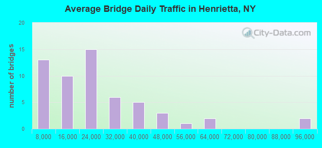
- 1,333,177Total average daily traffic
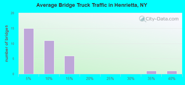
- 44,815Total average daily truck traffic
- National Bridge Inventory (NBI) Registered Bridges for Henrietta
- No street view available for this location
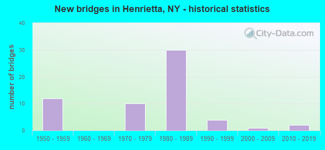
- New bridges - historical statistics
- 121950-1959
- 101970-1979
- 301980-1989
- 41990-1999
- 12000-2009
- 22010-2019
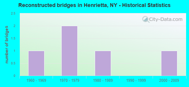
- Reconstructed bridges - Historical Statistics
- 11960-1969
- 21970-1979
- 11980-1989
- 01990-1999
- 12000-2009
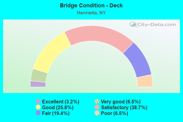
- Bridge Condition - Deck
- 3.2%Excellent
- 6.5%Very good
- 25.8%Good
- 38.7%Satisfactory
- 19.4%Fair
- 6.5%Poor
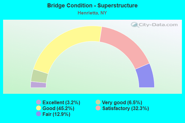
- Bridge Condition - Superstructure
- 3.2%Excellent
- 6.5%Very good
- 45.2%Good
- 32.3%Satisfactory
- 12.9%Fair
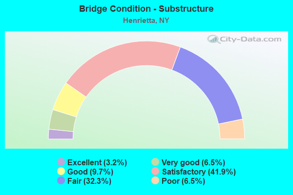
- Bridge Condition - Substructure
- 3.2%Excellent
- 6.5%Very good
- 9.7%Good
- 41.9%Satisfactory
- 32.3%Fair
- 6.5%Poor
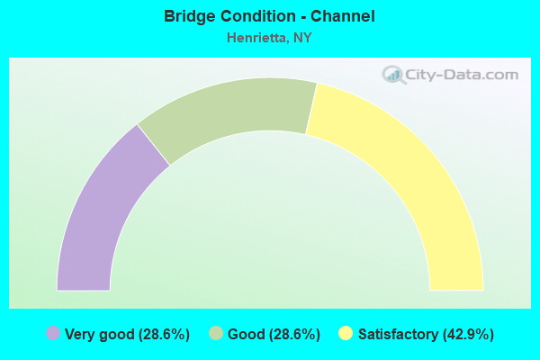
- Bridge Condition - Channel
- 28.6%Very good
- 28.6%Good
- 42.9%Satisfactory
Find on map >> Show street view
Structure Number: 1070089, Location: .3 MI N JCT I390 & I90 (Lat: 43.052592, Lng: -77.646650), Route carried "under" structure: Interstate , Year Built: 1980, Structure Length: 0. m, Average Daily Traffic: 6,000 (year 2015), Features Intersected: 3901390143031083, RTE I3, Facility Carried by Structure: RAMP TO THRUWAY
Minimum Vertical Clearance: 5.08m (16.67ft), Kilometerpoint: 13.290, Lanes on structure: 2, Lanes under structure: 1, Material/Design: Steel, Design/Construction: Stringer/Multi-beam, Length of Maximum Span: 30.4m (99.7ft)
Find on map >> Show street view
Structure Number: 1070091, Location: IN WEST HENRIETTA (Lat: 43.047781, Lng: -77.648444), Route carried "under" structure: Interstate 90, Year Built: 1980, Structure Length: 0. m, Average Daily Traffic: 45,000 (year 1981), Features Intersected: 90I 90I00003623 WB, RTE
Minimum Vertical Clearance: 5.51m (18.08ft), Kilometerpoint: 582.925, Lanes on structure: 2, Lanes under structure: 3, Toll: On toll road, Material/Design: Steel, Design/Construction: Stringer/Multi-beam, Length of Maximum Span: 30.4m (99.7ft)
Find on map >> Show street view
Structure Number: 1070092, Location: IN WEST HENRIETTA (Lat: 43.048011, Lng: -77.647914), Route carried "under" structure: Interstate 90, Year Built: 1980, Structure Length: 0. m, Average Daily Traffic: 45,000 (year 1981), Features Intersected: 90I 90I00003623 WB, RTE
Minimum Vertical Clearance: 5.21m (17.09ft), Kilometerpoint: 582.876, Lanes on structure: 3, Lanes under structure: 3, Material/Design: Steel, Design/Construction: Stringer/Multi-beam, Length of Maximum Span: 30.4m (99.7ft)
Find on map >> Show street view
Structure Number: 107079, Location: 0.5 MI N JCT RTS 252&390I (Lat: 43.095183, Lng: -77.602069), Route carried "under" structure: Interstate 390, Year Built: 1981, Structure Length: 0. m, Average Daily Traffic: 88,227 (year 2002), Features Intersected: 390I390I43031123, RTE I3, Facility Carried by Structure: BRIGH/HENR-T L RD
Minimum Vertical Clearance: 4.42m (14.50ft), Kilometerpoint: 18.809, Lanes on structure: 4, Lanes under structure: 4, Material/Design: Steel, Design/Construction: Stringer/Multi-beam, Length of Maximum Span: 35.6m (116.8ft)
Find on map >> Show street view
Structure Number: 1070811, Location: JCT OF RTS 252 & 390I (Lat: 43.087189, Lng: -77.605031), Route carried "under" structure: State highway 252, Year Built: 1981, Structure Length: 0. m, Average Daily Traffic: 33,684 (year 2002), Features Intersected: RTE 252, Facility Carried by Structure: RTE I390
Minimum Vertical Clearance: 4.67m (15.32ft), Kilometerpoint: 13.837, Lanes on structure: 4, Lanes under structure: 7, Material/Design: Steel, Design/Construction: Stringer/Multi-beam, Length of Maximum Span: 40.5m (132.9ft)
Find on map >> Show street view
Structure Number: 1070812, Location: JCT OF RTS 252 & 390I (Lat: 43.087261, Lng: -77.604500), Route carried "under" structure: State highway 252, Year Built: 1981, Structure Length: 0. m, Average Daily Traffic: 33,684 (year 2002), Features Intersected: RTE 252, Facility Carried by Structure: RTE I390
Minimum Vertical Clearance: 4.67m (15.32ft), Kilometerpoint: 13.837, Lanes on structure: 4, Lanes under structure: 7, Material/Design: Steel, Design/Construction: Stringer/Multi-beam, Length of Maximum Span: 40.2m (131.9ft)
Find on map >> Show street view
Structure Number: 107082, Location: JCT.OF RTS 15A & 390I (Lat: 43.084050, Lng: -77.607969), Route carried "under" structure: Interstate 390, Year Built: 1981, Structure Length: 0. m, Average Daily Traffic: 88,227 (year 2002), Features Intersected: 390I390I43031115SB, RTE, Facility Carried by Structure: RTE 15A
Minimum Vertical Clearance: 4.88m (16.01ft), Kilometerpoint: 18.504, Lanes on structure: 5, Lanes under structure: 3, Material/Design: Steel, Design/Construction: Stringer/Multi-beam, Length of Maximum Span: 32.6m (107.0ft)
Find on map >> Show street view
Structure Number: 107966, Location: Ramp NB 390 to Rte 15 (Lat: 43.110231, Lng: -77.618842), Route carried "under" structure: Ramp Other road , Year Built: 2016, Structure Length: 0. m, Features Intersected: Ramp DH, Facility Carried by Structure: Ramp NFE
Minimum Vertical Clearance: 4.62m (15.16ft), Kilometerpoint: 0.000, Lanes on structure: 1, Lanes under structure: 1, Material/Design: Concrete, Design/Construction: Frame, Length of Maximum Span: 13.1m (43.0ft)
Find on map >> Show street view
Structure Number: 55106, Location: EXIT 46 90I (Lat: 43.047703, Lng: -77.651247), Route carried "under" structure: Interstate 90, Year Built: 1953, Structure Length: 0. m, Average Daily Traffic: 15,060 (year 2014), Features Intersected: 90IX, RTE I90
Minimum Vertical Clearance: 4.52m (14.83ft), Kilometerpoint: 583.166, Lanes on structure: 2, Lanes under structure: 3, Toll: On Interstate toll segment, Material/Design: Steel, Design/Construction: Stringer/Multi-beam, Length of Maximum Span: 21.3m (69.9ft)
Find on map >> Show street view
Structure Number: 551087, Location: 0.3 MI E OF EXIT 46 90I (Lat: 43.047883, Lng: -77.645128), Route carried "under" structure: Interstate 90, Year Built: 1952, Structure Length: 0. m, Average Daily Traffic: 30,172 (year 2015), Features Intersected: 90IX WB, RTE I90, Facility Carried by Structure: MIDDLE RD
Minimum Vertical Clearance: 4.55m (14.93ft), Kilometerpoint: 582.651, Lanes on structure: 2, Lanes under structure: 2, Toll: On Interstate toll segment, Material/Design: Steel, Design/Construction: Stringer/Multi-beam, Length of Maximum Span: 19.8m (65.0ft)
Find on map >> Show street view
Structure Number: 551088, Location: 2.3 MI E OF EXIT 46 90I (Lat: 43.047156, Lng: -77.599475), Route carried "under" structure: Interstate 90, Year Built: 1952, Structure Length: 0. m, Average Daily Traffic: 13,246 (year 1977), Features Intersected: 90IX, RTE I90, Facility Carried by Structure: PINNACLE RD
Minimum Vertical Clearance: 4.60m (15.09ft), Kilometerpoint: 578.902, Lanes on structure: 2, Lanes under structure: 2, Toll: On Interstate toll segment, Material/Design: Steel, Design/Construction: Stringer/Multi-beam, Length of Maximum Span: 21.3m (69.9ft)
Find on map >> Show street view
Structure Number: 55109, Location: 2.3 MI W OF EXIT 46 90I (Lat: 43.042169, Lng: -77.696231), Route carried "under" structure: Interstate 90, Year Built: 1954, Structure Length: 0. m, Average Daily Traffic: 12,397 (year 1977), Features Intersected: 90IX EB, RTE I90, Facility Carried by Structure: CR 84 E RIVER RD
Minimum Vertical Clearance: 4.52m (14.83ft), Kilometerpoint: 586.867, Lanes on structure: 2, Lanes under structure: 2, Toll: On Interstate toll segment, Material/Design: Steel, Design/Construction: Stringer/Multi-beam, Length of Maximum Span: 22.9m (75.1ft)
Find on map >> Show street view
Structure Number: 770167, Location: 0.3 MI N JCT SH15 & SH252 (Lat: 43.091892, Lng: -77.634225), Route carried "under" structure: State highway 15, Year Built: 1977, Structure Length: 0. m, Average Daily Traffic: 22,935 (year 1999), Features Intersected: RTE 15, Facility Carried by Structure: CSX TRANSPRTATION
Minimum Vertical Clearance: 4.47m (14.67ft), Kilometerpoint: 17.779, Lanes under structure: 4, Material/Design: Steel, Design/Construction: Girder and Floorbeam System, Length of Maximum Span: 25.2m (82.7ft)
Find on map >> Show street view
Structure Number: 770181, Location: 0.4MI N JCT RTS 15A + 252 (Lat: 43.092706, Lng: -77.611003), Route carried "under" structure: State highway 15A, Year Built: 1976, Structure Length: 0. m, Average Daily Traffic: 55,000 (year 1978), Features Intersected: RTE 15A, Facility Carried by Structure: CSX TRANSPRTATION
Minimum Vertical Clearance: 4.49m (14.73ft), Kilometerpoint: 38.101, Lanes under structure: 4, Material/Design: Steel, Design/Construction: Girder and Floorbeam System, Length of Maximum Span: 23.4m (76.8ft)
Find on map >> Show street view
Structure Number: 77021, Location: .5 MI NE JCT SH 15A/SH252 (Lat: 43.092992, Lng: -77.602783), Route carried "under" structure: Interstate , Year Built: 1981, Structure Length: 0. m, Features Intersected: 390I390I43031121NB, RTE, Facility Carried by Structure: CSX TRANSPRTATION
Minimum Vertical Clearance: 4.62m (15.16ft), Kilometerpoint: 17.860, Lanes under structure: 5, Material/Design: Steel, Design/Construction: Girder and Floorbeam System, Length of Maximum Span: 36.5m (119.8ft)
Find on map >> Show street view
Structure Number: 77021, Location: .5 MI NE JCT SH 15A/SH252 (Lat: 43.092992, Lng: -77.602783), Route carried "under" structure: Interstate 390, Year Built: 1981, Structure Length: 0. m, Average Daily Traffic: 60,213 (year 2002), Features Intersected: 390I390I43031121NB, RTE, Facility Carried by Structure: CSX TRANSPRTATION
Minimum Vertical Clearance: 4.75m (15.58ft), Kilometerpoint: 17.860, Lanes under structure: 4, Material/Design: Steel, Design/Construction: Girder and Floorbeam System, Length of Maximum Span: 36.5m (119.8ft)