Bridge Statistics for Hillsboro, Missouri (MO)
Condition, Traffic, Stress, Structural Evaluation, Project Costs
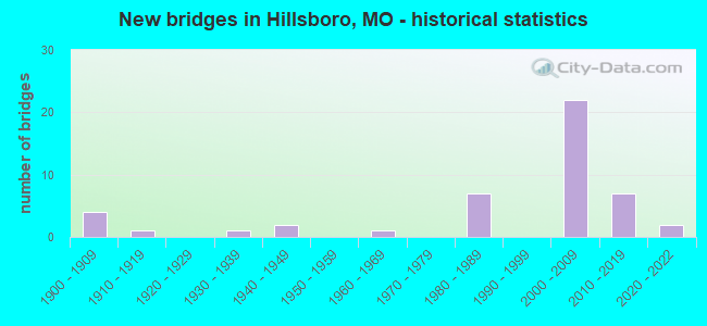
- New bridges - historical statistics
- 41900-1909
- 11910-1919
- 11930-1939
- 21940-1949
- 11960-1969
- 71980-1989
- 222000-2009
- 72010-2019
- 22020-2022

- Reconstructed bridges - Historical Statistics
- 21970-1979
- 01980-1989
- 31990-1999
- 22000-2009


- Bridge Condition - Deck
- 3.2%Excellent
- 6.5%Very good
- 51.6%Good
- 29.0%Satisfactory
- 9.7%Fair

- Bridge Condition - Superstructure
- 12.9%Excellent
- 3.2%Very good
- 51.6%Good
- 16.1%Satisfactory
- 16.1%Fair

- Bridge Condition - Substructure
- 6.5%Excellent
- 25.8%Very good
- 35.5%Good
- 29.0%Satisfactory
- 3.2%Fair

- Bridge Condition - Channel
- 9.1%Very good
- 18.2%Good
- 42.4%Satisfactory
- 27.3%Fair
- 3.0%Poor

- Bridge Condition - Culverts
- 37.5%Good
- 50.0%Satisfactory
- 12.5%Fair
Find on map >> Show street view
Structure Number: 18504, Location: S 20 T 41 N R 4 E (Lat: 38.266756, Lng: -90.596172), Route carried "on" structure: County highway 159, Year Built: 1984, Status: Open, Structure Length: 0.91m (2.99ft), Average Daily Traffic: 182 (year 2021), Truck Traffic: 2%, Average Future Daily Traffic: 364 (year 2041), Design Load: H 15, Features Intersected: TRIB OF BELEWS CR, Facility Carried by Structure: KLONDIKE RD
Minimum Vertical Clearance: 30+ m (98+ ft), Kilometerpoint: 4.667, Lanes on structure: 2, Owner: County Highway Agency, Approaching Roadway Width: 6.7m (22.0ft), Material/Design: Prestressed concrete, Design/Construction: Box Beam or Girders - Multiple, Number Of Spans In Main Unit: 1, Length of Maximum Span: 8.5m (27.9ft), Curb-To-Curb Width: 7.7m (25.3ft), Out-to-Out Width: 7.7m (25.3ft)
Condition: Deck: Fair, Superstructure: Fair, Substructure: Satisfactory, Channel: Satisfactory, Operating Rating: 54.9 metric tons, Method Used To Determine Operating Rating: Allowable Stress (AS), Inventory Rating: 30.6 metric tons, Method Used To Determine Inventory Rating: Allowable Stress (AS), Structural Evaluation: Somewhat better than minimum adequacy, Deck Geometry: Somewhat better than minimum adequacy, Waterway Adequacy: Better than present minimum criteria, Approach Roadway Alignment: Somewhat better than minimum adequacy, Designated Inspection Frequency: Every 24 months, Inspection Date: January 2021, Deck Structure Type: Concrete Precast Panels, Wearing Surface/Protective System: Wearing Surface: Bituminous
Find on map >> Show street view
Structure Number: 18513, Location: S 17 T 41 N R 4 E (Lat: 38.292311, Lng: -90.600114), Route carried "on" structure: County highway 158, Year Built: 1986, Status: Posted for load, Structure Length: 1.86m (6.10ft), Average Daily Traffic: 163 (year 2021), Truck Traffic: 2%, Average Future Daily Traffic: 326 (year 2041), Design Load: HS 15, Features Intersected: BELEWS CR, Facility Carried by Structure: CLAYTON HUSKEY
Minimum Vertical Clearance: 30+ m (98+ ft), Kilometerpoint: 0.322, Lanes on structure: 2, Owner: County Highway Agency, Approaching Roadway Width: 7.6m (24.9ft), Material/Design: Prestressed concrete, Design/Construction: Box Beam or Girders - Multiple, Number Of Spans In Main Unit: 1, Length of Maximum Span: 18.3m (60.0ft), Curb-To-Curb Width: 7.7m (25.3ft), Out-to-Out Width: 7.8m (25.6ft)
Condition: Deck: Fair, Superstructure: Fair, Substructure: Satisfactory, Channel: Fair, Operating Rating: 49.5 metric tons, Method Used To Determine Operating Rating: Load Factor (LF), Inventory Rating: 16.2 metric tons, Method Used To Determine Inventory Rating: Load Factor (LF), Structural Evaluation: Somewhat better than minimum adequacy, Deck Geometry: Somewhat better than minimum adequacy, Waterway Adequacy: Better than present minimum criteria, Approach Roadway Alignment: Meets minimum limits, Bridge Posting: Required (Relationship of Operating Rating to Maximum Legal Load: > 39.9% below), Designated Inspection Frequency: Every 24 months, Inspection Date: Febuary 2021, Deck Structure Type: Concrete Precast Panels, Wearing Surface/Protective System: Wearing Surface: Bituminous
Find on map >> Show street view
Structure Number: 18747, Location: S 10 T 41 N R 4 E (Lat: 38.300342, Lng: -90.517250), Route carried "on" structure: County highway 107, Year Built: 1980, Status: Posted for load, Structure Length: 0.79m (2.59ft), Average Daily Traffic: 676 (year 2021), Truck Traffic: 5%, Average Future Daily Traffic: 1,352 (year 2041), Features Intersected: TRIB OF SANDY CR, Facility Carried by Structure: OLD LEMAY FERRY RD
Minimum Vertical Clearance: 30+ m (98+ ft), Kilometerpoint: 3.380, Lanes on structure: 2, Owner: County Highway Agency, Approaching Roadway Width: 7.6m (24.9ft), Skew: 3 degrees, Material/Design: Concrete continuous, Design/Construction: Culvert, Number Of Spans In Main Unit: 2, Length of Maximum Span: 3.7m (12.1ft), Curb-To-Curb Width: 10.1m (33.1ft), Out-to-Out Width: 10.7m (35.1ft)
Condition: Channel: Satisfactory, Culverts: Good, Operating Rating: 49.5 metric tons, Method Used To Determine Operating Rating: Allowable Stress (AS), Inventory Rating: 16.2 metric tons, Method Used To Determine Inventory Rating: Allowable Stress (AS), Structural Evaluation: Meets minimum limits, Deck Geometry: Equal to present minimum criteria, Waterway Adequacy: Equal to present desirable criteria, Approach Roadway Alignment: Equal to present desirable criteria, Designated Inspection Frequency: Every 24 months, Inspection Date: January 2021
Find on map >> Show street view
Structure Number: 18773, Location: S 19 T 41 N R 5 E (Lat: 38.269989, Lng: -90.503617), Route carried "on" structure: County highway 178, Year Built: 1900, Year Reconstructed: 1990, Status: Posted for load, Structure Length: 0.94m (3.08ft), Average Daily Traffic: 341 (year 2021), Truck Traffic: 10%, Average Future Daily Traffic: 580 (year 2041), Design Load: HS 20, Features Intersected: TRIB OF SANDY CR, Facility Carried by Structure: JARVIS RD
Minimum Vertical Clearance: 30+ m (98+ ft), Kilometerpoint: 0.209, Lanes on structure: 2, Owner: County Highway Agency, Approaching Roadway Width: 6.4m (21.0ft), Material/Design: Prestressed concrete continuous, Design/Construction: Slab, Number Of Spans In Main Unit: 1, Length of Maximum Span: 8.8m (28.9ft), Curb-To-Curb Width: 7.4m (24.3ft), Out-to-Out Width: 8.0m (26.2ft)
Condition: Deck: Satisfactory, Superstructure: Satisfactory, Substructure: Satisfactory, Channel: Fair, Operating Rating: 58.5 metric tons, Method Used To Determine Operating Rating: Allowable Stress (AS), Inventory Rating: 32.4 metric tons, Method Used To Determine Inventory Rating: Allowable Stress (AS), Structural Evaluation: Equal to present minimum criteria, Deck Geometry: Somewhat better than minimum adequacy, Waterway Adequacy: Equal to present desirable criteria, Approach Roadway Alignment: Equal to present minimum criteria, Designated Inspection Frequency: Every 24 months, Inspection Date: January 2021, Deck Structure Type: Concrete Cast-file-Place, Wearing Surface/Protective System: Wearing Surface: Monolithic Concrete
Find on map >> Show street view
Structure Number: 18905, Location: S 12 T 41 N R 4 E (Lat: 38.295697, Lng: -90.520975), Route carried "on" structure: County highway 173, Year Built: 1910, Year Reconstructed: 1984, Status: Posted for load, Structure Length: 1.71m (5.61ft), Average Daily Traffic: 750 (year 2021), Truck Traffic: 5%, Average Future Daily Traffic: 1,500 (year 2041), Design Load: H 15, Features Intersected: SANDY CR, Facility Carried by Structure: GOLDMAN RD
Minimum Vertical Clearance: 30+ m (98+ ft), Kilometerpoint: 0.161, Lanes on structure: 2, Owner: County Highway Agency, Approaching Roadway Width: 7.6m (24.9ft), Material/Design: Prestressed concrete, Design/Construction: Box Beam or Girders - Multiple, Number Of Spans In Main Unit: 1, Length of Maximum Span: 16.8m (55.1ft), Curb-To-Curb Width: 7.7m (25.3ft), Out-to-Out Width: 7.7m (25.3ft)
Condition: Deck: Fair, Superstructure: Fair, Substructure: Good, Channel: Satisfactory, Operating Rating: 61.2 metric tons, Method Used To Determine Operating Rating: Allowable Stress (AS), Inventory Rating: 36.9 metric tons, Method Used To Determine Inventory Rating: Allowable Stress (AS), Structural Evaluation: Somewhat better than minimum adequacy, Deck Geometry: Meets minimum limits, Waterway Adequacy: Better than present minimum criteria, Approach Roadway Alignment: Equal to present desirable criteria, Designated Inspection Frequency: Every 24 months, Inspection Date: January 2021, Deck Structure Type: Concrete Precast Panels, Wearing Surface/Protective System: Wearing Surface: Bituminous
Find on map >> Show street view
Structure Number: 18935, Location: S 18 T 41 N R 5 E (Lat: 38.283325, Lng: -90.505228), Route carried "on" structure: County highway 177, Year Built: 1900, Year Reconstructed: 1990, Status: Posted for load, Structure Length: 0.94m (3.08ft), Average Daily Traffic: 670 (year 2021), Truck Traffic: 1%, Average Future Daily Traffic: 1,340 (year 2041), Design Load: HS 20, Features Intersected: TRIB OF SANDY CR, Facility Carried by Structure: SANDY VALLEY RD
Minimum Vertical Clearance: 30+ m (98+ ft), Kilometerpoint: 0.161, Lanes on structure: 2, Owner: County Highway Agency, Approaching Roadway Width: 7.9m (25.9ft), Material/Design: Prestressed concrete continuous, Design/Construction: Slab, Number Of Spans In Main Unit: 1, Length of Maximum Span: 8.8m (28.9ft), Curb-To-Curb Width: 7.4m (24.3ft), Out-to-Out Width: 7.9m (25.9ft)
Condition: Deck: Satisfactory, Superstructure: Satisfactory, Substructure: Satisfactory, Channel: Fair, Operating Rating: 58.5 metric tons, Method Used To Determine Operating Rating: Allowable Stress (AS), Inventory Rating: 32.4 metric tons, Method Used To Determine Inventory Rating: Allowable Stress (AS), Structural Evaluation: Equal to present minimum criteria, Deck Geometry: Meets minimum limits, Waterway Adequacy: Equal to present desirable criteria, Approach Roadway Alignment: Equal to present desirable criteria, Designated Inspection Frequency: Every 24 months, Inspection Date: January 2021, Deck Structure Type: Concrete Cast-file-Place, Wearing Surface/Protective System: Wearing Surface: Bituminous
Find on map >> Show street view
Structure Number: 20146, Location: S 1 T 40 N R 4 E (Lat: 38.222861, Lng: -90.517000), Route carried "on" structure: County highway 248, Year Built: 1986, Status: Open, Structure Length: 0.70m (2.30ft), Average Daily Traffic: 253 (year 2021), Truck Traffic: 10%, Average Future Daily Traffic: 506 (year 2041), Features Intersected: LITTLE CR, Facility Carried by Structure: BUCKEYE RD
Minimum Vertical Clearance: 30+ m (98+ ft), Kilometerpoint: 0.161, Lanes on structure: 2, Owner: County Highway Agency, Approaching Roadway Width: 7.3m (24.0ft), Material/Design: Concrete continuous, Design/Construction: Culvert, Number Of Spans In Main Unit: 2, Length of Maximum Span: 3.0m (9.8ft), Curb-To-Curb Width: 7.9m (25.9ft), Out-to-Out Width: 8.5m (27.9ft)
Condition: Channel: Satisfactory, Culverts: Satisfactory, Operating Rating: 49.5 metric tons, Method Used To Determine Operating Rating: Allowable Stress (AS), Inventory Rating: 16.2 metric tons, Method Used To Determine Inventory Rating: Allowable Stress (AS), Structural Evaluation: Somewhat better than minimum adequacy, Deck Geometry: Somewhat better than minimum adequacy, Waterway Adequacy: Equal to present desirable criteria, Approach Roadway Alignment: Equal to present desirable criteria, Designated Inspection Frequency: Every 24 months, Inspection Date: January 2021, Deck Structure Type: Concrete Cast-file-Place, Wearing Surface/Protective System: Wearing Surface: Bituminous
Find on map >> Show street view
Structure Number: 20187, Location: S 31 T 41 N R 5 E (Lat: 38.236139, Lng: -90.515611), Route carried "on" structure: County highway 248, Year Built: 1900, Year Reconstructed: 2009, Status: Posted for load, Structure Length: 0.93m (3.05ft), Average Daily Traffic: 400 (year 2021), Truck Traffic: 10%, Average Future Daily Traffic: 800 (year 2041), Design Load: HS 20, Features Intersected: LITTLE CR, Facility Carried by Structure: BUCKEYE RD
Minimum Vertical Clearance: 30+ m (98+ ft), Kilometerpoint: 2.092, Lanes on structure: 2, Owner: County Highway Agency, Approaching Roadway Width: 7.3m (24.0ft), Material/Design: Prestressed concrete, Design/Construction: Box Beam or Girders - Multiple, Number Of Spans In Main Unit: 1, Length of Maximum Span: 9.0m (29.5ft), Curb-To-Curb Width: 7.9m (25.9ft), Out-to-Out Width: 8.2m (26.9ft)
Condition: Deck: Good, Superstructure: Good, Substructure: Good, Channel: Satisfactory, Operating Rating: 81.0 metric tons, Method Used To Determine Operating Rating: Load Factor (LF), Inventory Rating: 48.6 metric tons, Method Used To Determine Inventory Rating: Load Factor (LF), Structural Evaluation: Better than present minimum criteria, Deck Geometry: Somewhat better than minimum adequacy, Waterway Adequacy: Better than present minimum criteria, Approach Roadway Alignment: High priority of corrective action, Designated Inspection Frequency: Every 24 months, Inspection Date: January 2021, Deck Structure Type: Other, Wearing Surface/Protective System: Wearing Surface: Bituminous, Membrane: Preformed Fabric, Deck Protection: Other
Find on map >> Show street view
Structure Number: 20565, Location: S 21 T 40 N R 4 E (Lat: 38.184206, Lng: -90.575111), Route carried "on" structure: County highway 258, Year Built: 1905, Year Reconstructed: 1984, Status: Open, Structure Length: 2.07m (6.79ft), Average Daily Traffic: 513 (year 2021), Truck Traffic: 2%, Average Future Daily Traffic: 1,026 (year 2041), Features Intersected: COTTER CR, Facility Carried by Structure: WHITEHEAD RD
Minimum Vertical Clearance: 30+ m (98+ ft), Kilometerpoint: 4.587, Lanes on structure: 2, Owner: County Highway Agency, Approaching Roadway Width: 6.7m (22.0ft), Material/Design: Prestressed concrete, Design/Construction: Box Beam or Girders - Multiple, Number Of Spans In Main Unit: 1, Length of Maximum Span: 20.4m (66.9ft), Curb-To-Curb Width: 7.7m (25.3ft), Out-to-Out Width: 7.7m (25.3ft)
Condition: Deck: Satisfactory, Superstructure: Satisfactory, Substructure: Satisfactory, Channel: Satisfactory, Operating Rating: 35.1 metric tons, Method Used To Determine Operating Rating: Allowable Stress (AS), Inventory Rating: 18.9 metric tons, Method Used To Determine Inventory Rating: Allowable Stress (AS), Structural Evaluation: Somewhat better than minimum adequacy, Deck Geometry: Meets minimum limits, Waterway Adequacy: Better than present minimum criteria, Approach Roadway Alignment: Equal to present minimum criteria, Designated Inspection Frequency: Every 24 months, Inspection Date: Febuary 2021, Deck Structure Type: Concrete Cast-file-Place, Wearing Surface/Protective System: Wearing Surface: Bituminous
Find on map >> Show street view
Structure Number: 20624, Location: S 12 T 40 N R 3 E (Lat: 38.214056, Lng: -90.626250), Route carried "on" structure: County highway 261, Year Built: 1983, Year Reconstructed: 1998, Status: Open, Structure Length: 1.13m (3.71ft), Average Daily Traffic: 1,050 (year 2021), Truck Traffic: 2%, Average Future Daily Traffic: 2,100 (year 2041), Design Load: HS 20, Features Intersected: TRIB OF DRY CR, Facility Carried by Structure: BUTCHER BR RD
Minimum Vertical Clearance: 30+ m (98+ ft), Kilometerpoint: 2.414, Lanes on structure: 2, Owner: County Highway Agency, Approaching Roadway Width: 7.6m (24.9ft), Skew: 3 degrees, Material/Design: Prestressed concrete, Design/Construction: Box Beam or Girders - Multiple, Number Of Spans In Main Unit: 1, Length of Maximum Span: 11.0m (36.1ft), Curb-To-Curb Width: 7.6m (24.9ft), Out-to-Out Width: 7.6m (24.9ft)
Condition: Deck: Satisfactory, Superstructure: Satisfactory, Substructure: Satisfactory, Channel: Fair, Operating Rating: 58.5 metric tons, Method Used To Determine Operating Rating: Load Factor (LF), Inventory Rating: 39.6 metric tons, Method Used To Determine Inventory Rating: Load Factor (LF), Structural Evaluation: Equal to present minimum criteria, Deck Geometry: Meets minimum limits, Waterway Adequacy: Equal to present desirable criteria, Approach Roadway Alignment: Equal to present minimum criteria, Designated Inspection Frequency: Every 24 months, Inspection Date: Febuary 2021, Deck Structure Type: Concrete Precast Panels, Wearing Surface/Protective System: Wearing Surface: Bituminous
Find on map >> Show street view
Structure Number: 20626, Location: S 7 T 40 N R 4 E (Lat: 38.218583, Lng: -90.617806), Route carried "on" structure: County highway 261, Year Built: 1985, Status: Open, Structure Length: 1.40m (4.59ft), Average Daily Traffic: 848 (year 2021), Truck Traffic: 2%, Average Future Daily Traffic: 1,696 (year 2041), Features Intersected: TRIB OF BUTCHER CR, Facility Carried by Structure: BUTCHER BR RD
Minimum Vertical Clearance: 30+ m (98+ ft), Kilometerpoint: 3.219, Lanes on structure: 2, Owner: County Highway Agency, Approaching Roadway Width: 7.3m (24.0ft), Skew: 6 degrees, Material/Design: Concrete, Design/Construction: Culvert, Number Of Spans In Main Unit: 1, Length of Maximum Span: 13.7m (44.9ft), Curb-To-Curb Width: 7.4m (24.3ft), Out-to-Out Width: 7.8m (25.6ft)
Condition: Channel: Satisfactory, Culverts: Satisfactory, Operating Rating: 49.5 metric tons, Method Used To Determine Operating Rating: Allowable Stress (AS), Inventory Rating: 16.2 metric tons, Method Used To Determine Inventory Rating: Allowable Stress (AS), Structural Evaluation: Meets minimum limits, Deck Geometry: Meets minimum limits, Waterway Adequacy: Equal to present minimum criteria, Approach Roadway Alignment: Equal to present desirable criteria, Designated Inspection Frequency: Every 24 months, Inspection Date: Febuary 2021
Find on map >> Show street view
Structure Number: 29592, Location: S 23 T 41 N R 4 E (Lat: 38.268528, Lng: -90.550422), Route carried "on" structure: County highway , Year Built: 2003, Status: Open, Structure Length: 2.10m (6.89ft), Average Daily Traffic: 102 (year 2021), Truck Traffic: 10%, Average Future Daily Traffic: 184 (year 2041), Design Load: HS 20, Features Intersected: SANDY CR, Facility Carried by Structure: HAYDEN RD E
Minimum Vertical Clearance: 30+ m (98+ ft), Kilometerpoint: 1.284, Lanes on structure: 3, Owner: State Highway Agency, Approaching Roadway Width: 15.8m (51.8ft), Skew: 2 degrees, Material/Design: Steel, Design/Construction: Stringer/Multi-beam, Number Of Spans In Main Unit: 1, Length of Maximum Span: 21.0m (68.9ft), Curb-To-Curb Width: 15.8m (51.8ft), Out-to-Out Width: 16.7m (54.8ft)
Condition: Deck: Satisfactory, Superstructure: Good, Substructure: Good, Channel: Satisfactory, Inventory Rating: 65.7 metric tons, Method Used To Determine Inventory Rating: Load Factor (LF), Structural Evaluation: Better than present minimum criteria, Deck Geometry: Better than present minimum criteria, Waterway Adequacy: Superior to present desirable criteria, Approach Roadway Alignment: Equal to present desirable criteria, Designated Inspection Frequency: Every 24 months, Inspection Date: December 2020, Deck Structure Type: Concrete Cast-file-Place, Wearing Surface/Protective System: Wearing Surface: Monolithic Concrete, Deck Protection: Epoxy Coated Reinforcing
Find on map >> Show street view
Structure Number: 29596, Location: S 33 T 41 N R 4 E (Lat: 38.237347, Lng: -90.577900), Route carried "on" structure: State highway 21, Year Built: 2003, Status: Open, Structure Length: 0.63m (2.07ft), Average Daily Traffic: 12,442 (year 2021), Truck Traffic: 7%, Average Future Daily Traffic: 23,018 (year 2041), Design Load: HS 25 or greater, Features Intersected: BELEW CR
Minimum Vertical Clearance: 30+ m (98+ ft), Kilometerpoint: 44.609, Lanes on structure: 4, Base Highway Network: Yes, Owner: State Highway Agency, Approaching Roadway Width: 53.6m (175.9ft), Material/Design: Concrete, Design/Construction: Culvert, Number Of Spans In Main Unit: 2, Length of Maximum Span: 3.0m (9.8ft)
Condition: Channel: Satisfactory, Culverts: Satisfactory, Structural Evaluation: Equal to present minimum criteria, Waterway Adequacy: Superior to present desirable criteria, Approach Roadway Alignment: Equal to present desirable criteria, Designated Inspection Frequency: Every 24 months, Inspection Date: December 2020
Find on map >> Show street view
Structure Number: 29597, Location: S 33 T 41 N R 4 E (Lat: 38.237869, Lng: -90.577347), Route carried "on" structure: State highway 21, Year Built: 2003, Status: Open, Structure Length: 5.18m (16.99ft), Average Daily Traffic: 6,150 (year 2021), Truck Traffic: 8%, Average Future Daily Traffic: 11,378 (year 2041), Design Load: HS 25 or greater, Features Intersected: RT BB
Minimum Vertical Clearance: 8.51m (27.92ft), Kilometerpoint: 267.910, Lanes on structure: 2, Lanes under structure: 2, Base Highway Network: Yes, Owner: State Highway Agency, Approaching Roadway Width: 11.6m (38.1ft), Material/Design: Prestressed concrete continuous, Design/Construction: Stringer/Multi-beam, Number Of Spans In Main Unit: 3, Length of Maximum Span: 19.8m (65.0ft), Curb-To-Curb Width: 11.6m (38.1ft), Out-to-Out Width: 12.4m (40.7ft)
Condition: Deck: Good, Superstructure: Good, Substructure: Good, Operating Rating: 81.9 metric tons, Method Used To Determine Operating Rating: Load Factor (LF), Inventory Rating: 48.6 metric tons, Method Used To Determine Inventory Rating: Load Factor (LF), Structural Evaluation: Better than present minimum criteria, Deck Geometry: Better than present minimum criteria, Underclear: Meets minimum limits, Approach Roadway Alignment: Equal to present desirable criteria, Designated Inspection Frequency: Every 48 months, Inspection Date: December 2020, Deck Structure Type: Concrete Cast-file-Place, Wearing Surface/Protective System: Wearing Surface: Monolithic Concrete, Deck Protection: Epoxy Coated Reinforcing
Find on map >> Show street view
Structure Number: 29643, Location: S 33 T 41 N R 4 E (Lat: 38.238000, Lng: -90.577600), Route carried "on" structure: State highway 21, Year Built: 2003, Status: Open, Structure Length: 5.18m (16.99ft), Average Daily Traffic: 6,834 (year 2021), Truck Traffic: 9%, Average Future Daily Traffic: 12,643 (year 2041), Design Load: HS 25 or greater, Features Intersected: RT BB
Minimum Vertical Clearance: 30+ m (98+ ft), Kilometerpoint: 44.508, Lanes on structure: 2, Lanes under structure: 2, Base Highway Network: Yes, Owner: State Highway Agency, Approaching Roadway Width: 11.6m (38.1ft), Material/Design: Prestressed concrete continuous, Design/Construction: Stringer/Multi-beam, Number Of Spans In Main Unit: 3, Length of Maximum Span: 17.7m (58.1ft), Curb-To-Curb Width: 11.6m (38.1ft), Out-to-Out Width: 12.4m (40.7ft)
Condition: Deck: Good, Superstructure: Good, Substructure: Very good, Operating Rating: 81.9 metric tons, Method Used To Determine Operating Rating: Load Factor (LF), Inventory Rating: 48.6 metric tons, Method Used To Determine Inventory Rating: Load Factor (LF), Structural Evaluation: Better than present minimum criteria, Deck Geometry: Better than present minimum criteria, Underclear: Meets minimum limits, Approach Roadway Alignment: Equal to present desirable criteria, Designated Inspection Frequency: Every 24 months, Inspection Date: December 2020, Deck Structure Type: Concrete Cast-file-Place, Wearing Surface/Protective System: Wearing Surface: Monolithic Concrete, Deck Protection: Epoxy Coated Reinforcing
Find on map >> Show street view
Structure Number: 29648, Location: S 34 T 41 N R 4 E (Lat: 38.250247, Lng: -90.559422), Route carried "on" structure: State highway A, Year Built: 2003, Status: Open, Structure Length: 9.24m (30.31ft), Average Daily Traffic: 9,265 (year 2021), Truck Traffic: 5%, Average Future Daily Traffic: 15,751 (year 2041), Design Load: HS 25 or greater, Features Intersected: MO 21
Minimum Vertical Clearance: 30+ m (98+ ft), Kilometerpoint: 0.204, Lanes on structure: 4, Lanes under structure: 4, Base Highway Network: Yes, Owner: State Highway Agency, Approaching Roadway Width: 19.5m (64.0ft), Skew: 20 degrees, Material/Design: Steel continuous, Design/Construction: Stringer/Multi-beam, Number Of Spans In Main Unit: 2, Length of Maximum Span: 38.4m (126.0ft), Curb-To-Curb Width: 28.2m (92.5ft), Out-to-Out Width: 29.0m (95.1ft)
Condition: Deck: Satisfactory, Superstructure: Excellent, Substructure: Good, Operating Rating: 99.0 metric tons, Method Used To Determine Operating Rating: Load Factor (LF), Inventory Rating: 59.4 metric tons, Method Used To Determine Inventory Rating: Load Factor (LF), Structural Evaluation: Better than present minimum criteria, Deck Geometry: Superior to present desirable criteria, Underclear: Superior to present desirable criteria, Approach Roadway Alignment: Equal to present desirable criteria, Designated Inspection Frequency: Every 24 months, Inspection Date: December 2020, Deck Structure Type: Concrete Cast-file-Place, Wearing Surface/Protective System: Wearing Surface: Monolithic Concrete, Deck Protection: Epoxy Coated Reinforcing
Find on map >> Show street view
Structure Number: 2965, Location: S 22 T 41 N R 4 E (Lat: 38.266342, Lng: -90.554850), Route carried "on" structure: ServiceState highway 21, Year Built: 2003, Status: Open, Structure Length: 4.91m (16.11ft), Average Daily Traffic: 3,126 (year 2021), Truck Traffic: 2%, Average Future Daily Traffic: 5,627 (year 2041), Design Load: HS 20+Mod, Features Intersected: SANDY CR
Minimum Vertical Clearance: 30+ m (98+ ft), Kilometerpoint: 0.349, Lanes on structure: 2, Owner: State Highway Agency, Approaching Roadway Width: 12.2m (40.0ft), Skew: 3 degrees, Material/Design: Prestressed concrete continuous, Design/Construction: Stringer/Multi-beam, Number Of Spans In Main Unit: 3, Length of Maximum Span: 18.3m (60.0ft), Curb-To-Curb Width: 12.2m (40.0ft), Out-to-Out Width: 13.0m (42.7ft)
Condition: Deck: Satisfactory, Superstructure: Satisfactory, Substructure: Good, Channel: Very good, Operating Rating: 79.2 metric tons, Method Used To Determine Operating Rating: Load Factor (LF), Inventory Rating: 47.7 metric tons, Method Used To Determine Inventory Rating: Load Factor (LF), Structural Evaluation: Equal to present minimum criteria, Deck Geometry: Equal to present minimum criteria, Waterway Adequacy: Superior to present desirable criteria, Approach Roadway Alignment: Equal to present desirable criteria, Designated Inspection Frequency: Every 24 months, Inspection Date: December 2020, Deck Structure Type: Concrete Cast-file-Place, Wearing Surface/Protective System: Wearing Surface: Monolithic Concrete, Deck Protection: Epoxy Coated Reinforcing
Find on map >> Show street view
Structure Number: 30123, Location: S 12 T 41 N R 4 W (Lat: 38.298861, Lng: -90.519611), Route carried "on" structure: County highway 107, Year Built: 2004, Status: Posted for load, Structure Length: 0.79m (2.59ft), Average Daily Traffic: 1,466 (year 2021), Truck Traffic: 10%, Average Future Daily Traffic: 2,932 (year 2041), Design Load: HS 20, Features Intersected: TRIB OF SANDY CR, Facility Carried by Structure: OLD LEMAY FERRY RD
Minimum Vertical Clearance: 30+ m (98+ ft), Kilometerpoint: 0.000, Lanes on structure: 2, Owner: County Highway Agency, Approaching Roadway Width: 12.2m (40.0ft), Material/Design: Concrete, Design/Construction: Culvert, Number Of Spans In Main Unit: 1, Length of Maximum Span: 7.3m (24.0ft)
Condition: Channel: Fair, Culverts: Good, Operating Rating: 54.0 metric tons, Method Used To Determine Operating Rating: Load Factor (LF), Inventory Rating: 32.4 metric tons, Method Used To Determine Inventory Rating: Load Factor (LF), Structural Evaluation: Better than present minimum criteria, Waterway Adequacy: Somewhat better than minimum adequacy, Approach Roadway Alignment: Equal to present desirable criteria, Designated Inspection Frequency: Every 24 months, Inspection Date: January 2021
Find on map >> Show street view
Structure Number: 31519, Location: S 23 T 41 N R 4 E (Lat: 38.267103, Lng: -90.552706), Route carried "on" structure: State highway 21, Year Built: 2006, Status: Open, Structure Length: 10.11m (33.17ft), Average Daily Traffic: 7,019 (year 2021), Truck Traffic: 3%, Average Future Daily Traffic: 12,985 (year 2041), Design Load: HS 25 or greater, Features Intersected: SANDY CR
Minimum Vertical Clearance: 30+ m (98+ ft), Kilometerpoint: 272.104, Lanes on structure: 2, Base Highway Network: Yes, Owner: State Highway Agency, Approaching Roadway Width: 11.6m (38.1ft), Skew: 2 degrees, Material/Design: Prestressed concrete continuous, Design/Construction: Tee Beam, Number Of Spans In Main Unit: 3, Length of Maximum Span: 33.5m (109.9ft), Curb-To-Curb Width: 11.6m (38.1ft), Out-to-Out Width: 12.4m (40.7ft)
Condition: Deck: Satisfactory, Superstructure: Good, Substructure: Satisfactory, Channel: Satisfactory, Operating Rating: 54.0 metric tons, Method Used To Determine Operating Rating: Load Factor (LF), Inventory Rating: 32.4 metric tons, Method Used To Determine Inventory Rating: Load Factor (LF), Structural Evaluation: Equal to present minimum criteria, Deck Geometry: Better than present minimum criteria, Waterway Adequacy: Superior to present desirable criteria, Approach Roadway Alignment: Equal to present desirable criteria, Designated Inspection Frequency: Every 24 months, Inspection Date: December 2020, Deck Structure Type: Concrete Cast-file-Place, Wearing Surface/Protective System: Wearing Surface: Monolithic Concrete, Deck Protection: Epoxy Coated Reinforcing
Find on map >> Show street view
Structure Number: 3152, Location: S 22 T 41 N R 4 E (Lat: 38.267089, Lng: -90.552978), Route carried "on" structure: State highway 21, Year Built: 2006, Status: Open, Structure Length: 10.11m (33.17ft), Average Daily Traffic: 6,998 (year 2021), Truck Traffic: 9%, Average Future Daily Traffic: 12,946 (year 2041), Design Load: HS 25 or greater, Features Intersected: SANDY CR
Minimum Vertical Clearance: 30+ m (98+ ft), Kilometerpoint: 40.282, Lanes on structure: 2, Base Highway Network: Yes, Owner: State Highway Agency, Approaching Roadway Width: 11.6m (38.1ft), Skew: 2 degrees, Material/Design: Prestressed concrete continuous, Design/Construction: Tee Beam, Number Of Spans In Main Unit: 3, Length of Maximum Span: 33.5m (109.9ft), Curb-To-Curb Width: 11.6m (38.1ft), Out-to-Out Width: 12.4m (40.7ft)
Condition: Deck: Good, Superstructure: Good, Substructure: Satisfactory, Channel: Satisfactory, Operating Rating: 54.0 metric tons, Method Used To Determine Operating Rating: Load Factor (LF), Inventory Rating: 32.4 metric tons, Method Used To Determine Inventory Rating: Load Factor (LF), Structural Evaluation: Equal to present minimum criteria, Deck Geometry: Better than present minimum criteria, Waterway Adequacy: Superior to present desirable criteria, Approach Roadway Alignment: Equal to present desirable criteria, Designated Inspection Frequency: Every 24 months, Inspection Date: December 2020, Deck Structure Type: Concrete Cast-file-Place, Wearing Surface/Protective System: Wearing Surface: Monolithic Concrete, Deck Protection: Epoxy Coated Reinforcing
Find on map >> Show street view
Structure Number: 31524, Location: S 23 T 41 N R 4 E (Lat: 38.267739, Lng: -90.551794), Route carried "on" structure: Ramp State highway , Year Built: 2006, Status: Open, Structure Length: 5.55m (18.21ft), Average Daily Traffic: 289 (year 2021), Truck Traffic: 17%, Average Future Daily Traffic: 535 (year 2041), Design Load: HS 20+Mod, Features Intersected: SANDY CR, Facility Carried by Structure: RP MO21N TO HAYDEN
Minimum Vertical Clearance: 30+ m (98+ ft), Kilometerpoint: 0.575, Lanes on structure: 2, Base Highway Network: Yes, Owner: State Highway Agency, Approaching Roadway Width: 11.0m (36.1ft), Skew: 4 degrees, Material/Design: Prestressed concrete continuous, Design/Construction: Stringer/Multi-beam, Number Of Spans In Main Unit: 3, Length of Maximum Span: 21.3m (69.9ft), Curb-To-Curb Width: 11.0m (36.1ft), Out-to-Out Width: 11.8m (38.7ft)
Condition: Deck: Good, Superstructure: Good, Substructure: Good, Channel: Satisfactory, Operating Rating: 79.2 metric tons, Method Used To Determine Operating Rating: Load Factor (LF), Inventory Rating: 47.7 metric tons, Method Used To Determine Inventory Rating: Load Factor (LF), Structural Evaluation: Better than present minimum criteria, Deck Geometry: Better than present minimum criteria, Waterway Adequacy: Superior to present desirable criteria, Approach Roadway Alignment: Equal to present desirable criteria, Designated Inspection Frequency: Every 48 months, Inspection Date: December 2020, Deck Structure Type: Concrete Cast-file-Place, Wearing Surface/Protective System: Wearing Surface: Monolithic Concrete, Deck Protection: Epoxy Coated Reinforcing
Find on map >> Show street view
Structure Number: 31525, Location: S 22 T 41 N R 4 E (Lat: 38.266914, Lng: -90.553742), Route carried "on" structure: Ramp State highway , Year Built: 2006, Status: Open, Structure Length: 4.45m (14.60ft), Average Daily Traffic: 293 (year 2021), Truck Traffic: 10%, Average Future Daily Traffic: 542 (year 2041), Design Load: HS 20+Mod, Features Intersected: SANDY CR, Facility Carried by Structure: RP HAYDEN RD TO MO
Minimum Vertical Clearance: 30+ m (98+ ft), Kilometerpoint: 0.251, Lanes on structure: 1, Base Highway Network: Yes, Owner: State Highway Agency, Approaching Roadway Width: 9.1m (29.9ft), Skew: 1 degrees, Material/Design: Prestressed concrete continuous, Design/Construction: Stringer/Multi-beam, Number Of Spans In Main Unit: 3, Length of Maximum Span: 16.8m (55.1ft), Curb-To-Curb Width: 9.1m (29.9ft), Out-to-Out Width: 10.0m (32.8ft)
Condition: Deck: Good, Superstructure: Good, Substructure: Good, Channel: Good, Operating Rating: 83.7 metric tons, Method Used To Determine Operating Rating: Load Factor (LF), Inventory Rating: 50.4 metric tons, Method Used To Determine Inventory Rating: Load Factor (LF), Structural Evaluation: Better than present minimum criteria, Deck Geometry: Superior to present desirable criteria, Waterway Adequacy: Superior to present desirable criteria, Approach Roadway Alignment: Equal to present desirable criteria, Designated Inspection Frequency: Every 48 months, Inspection Date: December 2020, Deck Structure Type: Concrete Cast-file-Place, Wearing Surface/Protective System: Wearing Surface: Monolithic Concrete, Deck Protection: Epoxy Coated Reinforcing
Find on map >> Show street view
Structure Number: 32039, Location: S 12 T 41 N R 4 E (Lat: 38.299239, Lng: -90.542214), Route carried "on" structure: County highway , Year Built: 2007, Status: Open, Structure Length: 3.72m (12.20ft), Average Daily Traffic: 611 (year 2021), Truck Traffic: 6%, Average Future Daily Traffic: 1,100 (year 2041), Design Load: HS 20, Features Intersected: MO 21, Facility Carried by Structure: GLADE CHAPEL RD E
Minimum Vertical Clearance: 30+ m (98+ ft), Kilometerpoint: 2.353, Lanes on structure: 2, Lanes under structure: 4, Owner: State Highway Agency, Approaching Roadway Width: 7.3m (24.0ft), Skew: 3 degrees, Material/Design: Prestressed concrete continuous, Design/Construction: Stringer/Multi-beam, Number Of Spans In Main Unit: 2, Length of Maximum Span: 18.0m (59.1ft), Curb-To-Curb Width: 7.3m (24.0ft), Out-to-Out Width: 8.1m (26.6ft)
Condition: Deck: Good, Superstructure: Good, Substructure: Very good, Operating Rating: 81.9 metric tons, Method Used To Determine Operating Rating: Load Factor (LF), Inventory Rating: 44.1 metric tons, Method Used To Determine Inventory Rating: Load Factor (LF), Structural Evaluation: Better than present minimum criteria, Deck Geometry: Meets minimum limits, Underclear: Somewhat better than minimum adequacy, Approach Roadway Alignment: Equal to present minimum criteria, Designated Inspection Frequency: Every 48 months, Inspection Date: December 2020, Deck Structure Type: Concrete Cast-file-Place, Wearing Surface/Protective System: Wearing Surface: Monolithic Concrete, Deck Protection: Epoxy Coated Reinforcing
Find on map >> Show street view
Structure Number: 32091, Location: S 23 T 41 N R 4 E (Lat: 38.269050, Lng: -90.552558), Route carried "on" structure: State highway 21, Year Built: 2007, Status: Open, Structure Length: 2.44m (8.01ft), Average Daily Traffic: 7,019 (year 2021), Truck Traffic: 3%, Average Future Daily Traffic: 12,985 (year 2041), Design Load: HS 25 or greater, Features Intersected: CRD HAYDEN RD
Minimum Vertical Clearance: 30+ m (98+ ft), Kilometerpoint: 272.351, Lanes on structure: 2, Lanes under structure: 3, Base Highway Network: Yes, Owner: State Highway Agency, Approaching Roadway Width: 11.6m (38.1ft), Skew: 1 degrees, Material/Design: Prestressed concrete, Design/Construction: Stringer/Multi-beam, Number Of Spans In Main Unit: 1, Length of Maximum Span: 24.4m (80.1ft), Curb-To-Curb Width: 11.6m (38.1ft), Out-to-Out Width: 12.4m (40.7ft)
Condition: Deck: Good, Superstructure: Good, Substructure: Very good, Operating Rating: 70.2 metric tons, Method Used To Determine Operating Rating: Load Factor (LF), Inventory Rating: 42.3 metric tons, Method Used To Determine Inventory Rating: Load Factor (LF), Structural Evaluation: Better than present minimum criteria, Deck Geometry: Better than present minimum criteria, Underclear: Superior to present desirable criteria, Approach Roadway Alignment: Equal to present desirable criteria, Designated Inspection Frequency: Every 48 months, Inspection Date: December 2020, Deck Structure Type: Concrete Cast-file-Place, Wearing Surface/Protective System: Wearing Surface: Monolithic Concrete, Deck Protection: Epoxy Coated Reinforcing
Find on map >> Show street view
Structure Number: 32094, Location: S 23 T 41 N R 4 E (Lat: 38.269131, Lng: -90.552853), Route carried "on" structure: State highway 21, Year Built: 2007, Status: Open, Structure Length: 2.44m (8.01ft), Average Daily Traffic: 6,998 (year 2021), Truck Traffic: 9%, Average Future Daily Traffic: 12,946 (year 2041), Design Load: HS 25 or greater, Features Intersected: CRD HAYDEN RD
Minimum Vertical Clearance: 30+ m (98+ ft), Kilometerpoint: 40.097, Lanes on structure: 2, Lanes under structure: 3, Base Highway Network: Yes, Owner: State Highway Agency, Approaching Roadway Width: 11.6m (38.1ft), Skew: 1 degrees, Material/Design: Prestressed concrete, Design/Construction: Stringer/Multi-beam, Number Of Spans In Main Unit: 1, Length of Maximum Span: 24.4m (80.1ft), Curb-To-Curb Width: 11.6m (38.1ft), Out-to-Out Width: 12.4m (40.7ft)
Condition: Deck: Good, Superstructure: Good, Substructure: Very good, Operating Rating: 70.2 metric tons, Method Used To Determine Operating Rating: Load Factor (LF), Inventory Rating: 43.2 metric tons, Method Used To Determine Inventory Rating: Load Factor (LF), Structural Evaluation: Better than present minimum criteria, Deck Geometry: Better than present minimum criteria, Underclear: Superior to present desirable criteria, Approach Roadway Alignment: Equal to present desirable criteria, Designated Inspection Frequency: Every 48 months, Inspection Date: December 2020, Deck Structure Type: Concrete Cast-file-Place, Wearing Surface/Protective System: Wearing Surface: Monolithic Concrete, Deck Protection: Epoxy Coated Reinforcing
Find on map >> Show street view
Structure Number: 32913, Location: S 13 T 41 N R 4 E (Lat: 38.294750, Lng: -90.528967), Route carried "on" structure: County highway , Year Built: 1940, Year Reconstructed: 2009, Status: Posted for load, Structure Length: 4.82m (15.81ft), Average Daily Traffic: 3,266 (year 2021), Truck Traffic: 10%, Average Future Daily Traffic: 6,532 (year 2041), Design Load: H 15, Features Intersected: SANDY CR, Facility Carried by Structure: OLD HWY 21 S
Minimum Vertical Clearance: 30+ m (98+ ft), Kilometerpoint: 0.000, Lanes on structure: 2, Owner: County Highway Agency, Approaching Roadway Width: 8.8m (28.9ft), Skew: 1 degrees, Material/Design: Steel continuous, Design/Construction: Stringer/Multi-beam, Number Of Spans In Main Unit: 3, Length of Maximum Span: 16.0m (52.5ft), Curb-To-Curb Width: 8.8m (28.9ft), Out-to-Out Width: 8.8m (28.9ft)
Condition: Deck: Good, Superstructure: Fair, Substructure: Satisfactory, Channel: Poor, Operating Rating: 71.1 metric tons, Method Used To Determine Operating Rating: Load Factor (LF), Inventory Rating: 42.3 metric tons, Method Used To Determine Inventory Rating: Load Factor (LF), Structural Evaluation: Somewhat better than minimum adequacy, Deck Geometry: Meets minimum limits, Waterway Adequacy: Equal to present desirable criteria, Approach Roadway Alignment: Better than present minimum criteria, Designated Inspection Frequency: Every 24 months, Inspection Date: January 2021, Deck Structure Type: Concrete Cast-file-Place, Wearing Surface/Protective System: Wearing Surface: Monolithic Concrete, Deck Protection: Epoxy Coated Reinforcing
Find on map >> Show street view
Structure Number: 33249, Location: S 35 T 36 N R 12 W (Lat: 37.807925, Lng: -92.222953), Route carried "on" structure: ServiceState highway 44, Year Built: 2010, Status: Open, Structure Length: 3.59m (11.78ft), Average Daily Traffic: 2,302 (year 2021), Truck Traffic: 4%, Average Future Daily Traffic: 3,453 (year 2041), Features Intersected: BRADFORD CR
Minimum Vertical Clearance: 30+ m (98+ ft), Kilometerpoint: 0.029, Lanes on structure: 2, Owner: State Highway Agency, Approaching Roadway Width: 12.2m (40.0ft), Skew: 2 degrees, Material/Design: Prestressed concrete, Design/Construction: Tee Beam, Number Of Spans In Main Unit: 1, Length of Maximum Span: 34.7m (113.8ft), Curb-To-Curb Width: 12.2m (40.0ft), Out-to-Out Width: 14.9m (48.9ft)
Condition: Deck: Good, Superstructure: Good, Substructure: Very good, Channel: Good, Operating Rating: 93.6 metric tons, Method Used To Determine Operating Rating: Load Factor (LF), Inventory Rating: 34.2 metric tons, Method Used To Determine Inventory Rating: Load Factor (LF), Structural Evaluation: Better than present minimum criteria, Deck Geometry: Equal to present minimum criteria, Waterway Adequacy: Superior to present desirable criteria, Approach Roadway Alignment: Equal to present desirable criteria, Designated Inspection Frequency: Every 24 months, Inspection Date: October 2021, Deck Structure Type: Concrete Cast-file-Place, Wearing Surface/Protective System: Wearing Surface: Other, Deck Protection: Epoxy Coated Reinforcing
Find on map >> Show street view
Structure Number: 3325, Location: S 5 T 35 N R 32 W (Lat: 37.840539, Lng: -94.491967), Route carried "on" structure: US 54, Year Built: 1984, Status: Open, Structure Length: 8.75m (28.71ft), Average Daily Traffic: 4,418 (year 2021), Truck Traffic: 14%, Average Future Daily Traffic: 7,732 (year 2041), Design Load: HS 20+Mod, Features Intersected: DRYWOOD CR
Minimum Vertical Clearance: 30+ m (98+ ft), Kilometerpoint: 10.916, Lanes on structure: 2, Base Highway Network: Yes, Owner: State Highway Agency, Approaching Roadway Width: 13.4m (44.0ft), Skew: 3 degrees, Material/Design: Prestressed concrete continuous, Design/Construction: Stringer/Multi-beam, Number Of Spans In Main Unit: 5, Length of Maximum Span: 22.3m (73.2ft), Curb or Sidewalk Widths: Left: 0.2m (0.7ft), Right: 0.2m (0.7ft), Curb-To-Curb Width: 13.0m (42.7ft), Out-to-Out Width: 13.9m (45.6ft)
Condition: Deck: Good, Superstructure: Good, Substructure: Good, Channel: Fair, Operating Rating: 58.5 metric tons, Method Used To Determine Operating Rating: Load Factor (LF), Inventory Rating: 35.1 metric tons, Method Used To Determine Inventory Rating: Load Factor (LF), Structural Evaluation: Better than present minimum criteria, Deck Geometry: Equal to present minimum criteria, Waterway Adequacy: Equal to present desirable criteria, Approach Roadway Alignment: Equal to present desirable criteria, Designated Inspection Frequency: Every 24 months, Inspection Date: June 2021, Deck Structure Type: Concrete Cast-file-Place, Wearing Surface/Protective System: Wearing Surface: Monolithic Concrete, Deck Protection: Epoxy Coated Reinforcing
Find on map >> Show street view
Structure Number: 33361, Location: S 2018 T 41 N R 4 E (Lat: 38.281542, Lng: -90.538194), Route carried "on" structure: County highway , Year Built: 1940, Status: Posted for load, Structure Length: 1.38m (4.53ft), Average Daily Traffic: 3,266 (year 2021), Truck Traffic: 10%, Average Future Daily Traffic: 6,532 (year 2041), Design Load: HS 20, Features Intersected: CUNDIFF CR, Facility Carried by Structure: OLD HWY 21 S
Minimum Vertical Clearance: 30+ m (98+ ft), Kilometerpoint: 0.000, Lanes on structure: 2, Owner: County Highway Agency, Approaching Roadway Width: 11.0m (36.1ft), Skew: 4 degrees, Material/Design: Concrete continuous, Design/Construction: Culvert, Number Of Spans In Main Unit: 3, Length of Maximum Span: 3.0m (9.8ft)
Condition: Channel: Satisfactory, Culverts: Fair, Operating Rating: 35.1 metric tons, Method Used To Determine Operating Rating: Load Factor (LF), Inventory Rating: 21.6 metric tons, Method Used To Determine Inventory Rating: Load Factor (LF), Structural Evaluation: Somewhat better than minimum adequacy, Waterway Adequacy: Equal to present minimum criteria, Approach Roadway Alignment: Equal to present desirable criteria, Designated Inspection Frequency: Every 24 months, Inspection Date: January 2021
Find on map >> Show street view
Structure Number: 34403, Location: S 27 T 41 N R 4 E (Lat: 38.264939, Lng: -90.556978), Route carried "on" structure: County highway , Year Built: 1930, Status: Posted for load, Structure Length: 1.55m (5.09ft), Average Daily Traffic: 20 (year 2021), Truck Traffic: 1%, Average Future Daily Traffic: 40 (year 2041), Features Intersected: SANDY CR, Facility Carried by Structure: FARM RD
Minimum Vertical Clearance: 30+ m (98+ ft), Kilometerpoint: 0.000, Lanes on structure: 1, Owner: Local Agency, Approaching Roadway Width: 4.0m (13.1ft), Material/Design: Steel continuous, Design/Construction: Stringer/Multi-beam, Number Of Spans In Main Unit: 2, Length of Maximum Span: 7.0m (23.0ft), Curb-To-Curb Width: 3.9m (12.8ft), Out-to-Out Width: 4.3m (14.1ft)
Condition: Deck: Very good, Superstructure: Fair, Substructure: Fair, Channel: Fair, Operating Rating: 9.0 metric tons, Method Used To Determine Operating Rating: Load Factor (LF), Inventory Rating: 5.4 metric tons, Method Used To Determine Inventory Rating: Load Factor (LF), Structural Evaluation: High priority of replacement, Deck Geometry: Meets minimum limits, Waterway Adequacy: Better than present minimum criteria, Approach Roadway Alignment: Equal to present desirable criteria, Bridge Posting: Required (Relationship of Operating Rating to Maximum Legal Load: > 39.9% below), Length Of Structure Improvement: 0.22m (0.72ft), Designated Inspection Frequency: Every 24 months, Inspection Date: March 2021, Bridge Improvement Cost: $160,000, Roadway Improvement Cost: $16,000, Total Project Cost: $240,000 ( Estimate for 2022), Deck Structure Type: Wood or Timber, Wearing Surface/Protective System: Wearing Surface: Wood or Timber
Find on map >> Show street view
Structure Number: 3446, Location: S 22 T 40 N R 4 E (Lat: 38.185300, Lng: -90.560219), Route carried "on" structure: County highway 252, Year Built: 2014, Status: Open, Structure Length: 2.06m (6.76ft), Average Daily Traffic: 467 (year 2021), Truck Traffic: 2%, Average Future Daily Traffic: 934 (year 2041), Design Load: HS 20, Features Intersected: TRIB TO COTTER CR, Facility Carried by Structure: CASTLE RANCH RD
Minimum Vertical Clearance: 30+ m (98+ ft), Kilometerpoint: 0.000, Lanes on structure: 2, Owner: County Highway Agency, Approaching Roadway Width: 9.8m (32.2ft), Material/Design: Prestressed concrete, Design/Construction: Box Beam or Girders - Single/Spread, Number Of Spans In Main Unit: 1, Length of Maximum Span: 19.5m (64.0ft), Curb-To-Curb Width: 10.6m (34.8ft), Out-to-Out Width: 11.4m (37.4ft)
Condition: Deck: Good, Superstructure: Excellent, Substructure: Very good, Channel: Good, Operating Rating: 62.1 metric tons, Method Used To Determine Operating Rating: Load Factor (LF), Inventory Rating: 36.9 metric tons, Method Used To Determine Inventory Rating: Load Factor (LF), Structural Evaluation: Equal to present desirable criteria, Deck Geometry: Equal to present minimum criteria, Waterway Adequacy: Superior to present desirable criteria, Approach Roadway Alignment: Equal to present desirable criteria, Designated Inspection Frequency: Every 24 months, Inspection Date: January 2021, Deck Structure Type: Concrete Cast-file-Place, Wearing Surface/Protective System: Wearing Surface: Monolithic Concrete, Deck Protection: Epoxy Coated Reinforcing
Find on map >> Show street view
Structure Number: 34479, Location: S 21 T 40 N R 4 E (Lat: 38.189550, Lng: -90.579689), Route carried "on" structure: County highway 258, Year Built: 2014, Status: Open, Structure Length: 2.35m (7.71ft), Average Daily Traffic: 300 (year 2021), Truck Traffic: 5%, Average Future Daily Traffic: 600 (year 2041), Features Intersected: TRIB OF COTTER CR, Facility Carried by Structure: WHITEHEAD RD
Minimum Vertical Clearance: 30+ m (98+ ft), Kilometerpoint: 0.000, Lanes on structure: 2, Owner: County Highway Agency, Approaching Roadway Width: 11.0m (36.1ft), Skew: 3 degrees, Material/Design: Prestressed concrete, Design/Construction: Stringer/Multi-beam, Number Of Spans In Main Unit: 1, Length of Maximum Span: 22.3m (73.2ft), Curb-To-Curb Width: 11.0m (36.1ft), Out-to-Out Width: 11.9m (39.0ft)
Condition: Deck: Good, Superstructure: Good, Substructure: Good, Channel: Satisfactory, Operating Rating: 74.7 metric tons, Method Used To Determine Operating Rating: Load Factor (LF), Inventory Rating: 57.6 metric tons, Method Used To Determine Inventory Rating: Load Factor (LF), Structural Evaluation: Better than present minimum criteria, Deck Geometry: Equal to present desirable criteria, Waterway Adequacy: Superior to present desirable criteria, Approach Roadway Alignment: Better than present minimum criteria, Designated Inspection Frequency: Every 24 months, Inspection Date: Febuary 2021, Deck Structure Type: Concrete Cast-file-Place, Wearing Surface/Protective System: Deck Protection: Epoxy Coated Reinforcing
Find on map >> Show street view
Structure Number: 34699, Location: S 7 T 40 N R 4 E (Lat: 38.214167, Lng: -90.621333), Route carried "on" structure: County highway 261, Year Built: 2014, Status: Open, Structure Length: 1.92m (6.30ft), Average Daily Traffic: 1,050 (year 2021), Truck Traffic: 2%, Average Future Daily Traffic: 2,100 (year 2041), Features Intersected: BUTCHER BR, Facility Carried by Structure: BUTCHER BRANCH RD
Minimum Vertical Clearance: 30+ m (98+ ft), Kilometerpoint: 0.000, Lanes on structure: 2, Owner: County Highway Agency, Approaching Roadway Width: 8.5m (27.9ft), Skew: 3 degrees, Material/Design: Concrete, Design/Construction: Box Beam or Girders - Multiple, Number Of Spans In Main Unit: 1, Length of Maximum Span: 18.0m (59.1ft), Curb-To-Curb Width: 10.8m (35.4ft), Out-to-Out Width: 11.0m (36.1ft)
Condition: Deck: Satisfactory, Superstructure: Very good, Substructure: Good, Channel: Fair, Operating Rating: 63.0 metric tons, Method Used To Determine Operating Rating: Load Factor (LF), Inventory Rating: 45.9 metric tons, Method Used To Determine Inventory Rating: Load Factor (LF), Structural Evaluation: Better than present minimum criteria, Deck Geometry: Equal to present minimum criteria, Waterway Adequacy: Superior to present desirable criteria, Approach Roadway Alignment: Equal to present minimum criteria, Designated Inspection Frequency: Every 24 months, Inspection Date: Febuary 2021, Deck Structure Type: Concrete Cast-file-Place, Wearing Surface/Protective System: Wearing Surface: Monolithic Concrete, Deck Protection: Epoxy Coated Reinforcing
Find on map >> Show street view
Structure Number: 35248, Location: S 5 T 40 N R 5 E (Lat: 38.228819, Lng: -90.498581), Route carried "on" structure: County highway , Year Built: 2016, Status: Open, Structure Length: 5.34m (17.52ft), Average Daily Traffic: 400 (year 2021), Truck Traffic: 5%, Average Future Daily Traffic: 800 (year 2041), Features Intersected: LITTLE CREEK, Facility Carried by Structure: STROUP RD
Minimum Vertical Clearance: 30+ m (98+ ft), Kilometerpoint: 1.931, Lanes on structure: 2, Owner: County Highway Agency, Approaching Roadway Width: 9.1m (29.9ft), Skew: 5 degrees, Material/Design: Prestressed concrete continuous, Design/Construction: Stringer/Multi-beam, Number Of Spans In Main Unit: 3, Length of Maximum Span: 21.3m (69.9ft), Curb-To-Curb Width: 9.1m (29.9ft), Out-to-Out Width: 10.0m (32.8ft)
Condition: Deck: Good, Superstructure: Good, Substructure: Very good, Channel: Very good, Operating Rating: 69.3 metric tons, Method Used To Determine Operating Rating: Load Factor (LF), Inventory Rating: 48.6 metric tons, Method Used To Determine Inventory Rating: Load Factor (LF), Structural Evaluation: Better than present minimum criteria, Deck Geometry: Equal to present minimum criteria, Waterway Adequacy: Superior to present desirable criteria, Approach Roadway Alignment: Equal to present minimum criteria, Designated Inspection Frequency: Every 24 months, Inspection Date: January 2021, Deck Structure Type: Concrete Cast-file-Place, Wearing Surface/Protective System: Wearing Surface: Monolithic Concrete
Find on map >> Show street view
Structure Number: 35303, Location: S 29 T 41 N R 4 E (Lat: 38.264833, Lng: -90.592611), Route carried "on" structure: County highway 159, Year Built: 2016, Status: Open, Structure Length: 2.91m (9.55ft), Average Daily Traffic: 182 (year 2021), Truck Traffic: 10%, Average Future Daily Traffic: 364 (year 2041), Features Intersected: BELEWS CR, Facility Carried by Structure: KLONDIKE RD
Minimum Vertical Clearance: 30+ m (98+ ft), Kilometerpoint: 4.989, Lanes on structure: 2, Owner: County Highway Agency, Approaching Roadway Width: 7.3m (24.0ft), Material/Design: Prestressed concrete, Design/Construction: Tee Beam, Number Of Spans In Main Unit: 1, Length of Maximum Span: 28.0m (91.9ft), Curb-To-Curb Width: 9.1m (29.9ft), Out-to-Out Width: 10.0m (32.8ft)
Condition: Deck: Good, Superstructure: Good, Substructure: Very good, Channel: Good, Operating Rating: 82.8 metric tons, Method Used To Determine Operating Rating: Load Factor (LF), Inventory Rating: 51.3 metric tons, Method Used To Determine Inventory Rating: Load Factor (LF), Structural Evaluation: Better than present minimum criteria, Deck Geometry: Equal to present minimum criteria, Waterway Adequacy: Superior to present desirable criteria, Approach Roadway Alignment: Equal to present desirable criteria, Designated Inspection Frequency: Every 24 months, Inspection Date: January 2021, Deck Structure Type: Concrete Cast-file-Place, Wearing Surface/Protective System: Wearing Surface: Monolithic Concrete
Find on map >> Show street view
Structure Number: 35863, Location: S 25 T 41 N R 4 E (Lat: 38.261222, Lng: -90.532444), Route carried "on" structure: County highway 170, Year Built: 2018, Status: Open, Structure Length: 0.88m (2.89ft), Average Daily Traffic: 85 (year 2021), Truck Traffic: 2%, Average Future Daily Traffic: 170 (year 2041), Features Intersected: SANDY CR W, Facility Carried by Structure: HIGHLAND BAPTIST C
Minimum Vertical Clearance: 30+ m (98+ ft), Kilometerpoint: 2.092, Lanes on structure: 2, Owner: County Highway Agency, Approaching Roadway Width: 9.1m (29.9ft), Skew: 4 degrees, Material/Design: Concrete, Design/Construction: Culvert, Number Of Spans In Main Unit: 1, Length of Maximum Span: 8.2m (26.9ft), Curb-To-Curb Width: 9.1m (29.9ft), Out-to-Out Width: 11.2m (36.7ft)
Condition: Channel: Good, Culverts: Good, Operating Rating: 54.9 metric tons, Method Used To Determine Operating Rating: Load Factor (LF), Inventory Rating: 33.3 metric tons, Method Used To Determine Inventory Rating: Load Factor (LF), Structural Evaluation: Better than present minimum criteria, Deck Geometry: Better than present minimum criteria, Waterway Adequacy: Better than present minimum criteria, Approach Roadway Alignment: Equal to present minimum criteria, Designated Inspection Frequency: Every 24 months, Inspection Date: January 2021, Deck Structure Type: Concrete Cast-file-Place, Wearing Surface/Protective System: Wearing Surface: Monolithic Concrete, Deck Protection: Epoxy Coated Reinforcing
Find on map >> Show street view
Structure Number: 36211, Location: S 16 T 40 N R 4 E (Lat: 38.194994, Lng: -90.592319), Route carried "on" structure: County highway 264, Year Built: 2020, Status: Open, Structure Length: 1.68m (5.51ft), Average Daily Traffic: 300 (year 2021), Truck Traffic: 2%, Average Future Daily Traffic: 600 (year 2041), Design Load: HS 20, Features Intersected: TRIB TO COTTER CR, Facility Carried by Structure: WHITEHEAD RD
Minimum Vertical Clearance: 30+ m (98+ ft), Kilometerpoint: 2.253, Lanes on structure: 2, Owner: County Highway Agency, Approaching Roadway Width: 7.9m (25.9ft), Skew: 2 degrees, Material/Design: Prestressed concrete, Design/Construction: Box Beam or Girders - Single/Spread, Number Of Spans In Main Unit: 1, Length of Maximum Span: 15.6m (51.2ft), Curb-To-Curb Width: 9.1m (29.9ft), Out-to-Out Width: 10.0m (32.8ft)
Condition: Deck: Excellent, Superstructure: Excellent, Substructure: Excellent, Channel: Very good, Operating Rating: 74.7 metric tons, Method Used To Determine Operating Rating: Load Factor (LF), Inventory Rating: 57.6 metric tons, Method Used To Determine Inventory Rating: Load Factor (LF), Structural Evaluation: Superior to present desirable criteria, Deck Geometry: Equal to present minimum criteria, Waterway Adequacy: Superior to present desirable criteria, Approach Roadway Alignment: Equal to present desirable criteria, Designated Inspection Frequency: Every 24 months, Inspection Date: Febuary 2021, Deck Structure Type: Concrete Cast-file-Place, Wearing Surface/Protective System: Wearing Surface: Monolithic Concrete, Deck Protection: Epoxy Coated Reinforcing
Find on map >> Show street view
Structure Number: 36483, Location: S 10 T 41 N R 4 E (Lat: 38.306111, Lng: -90.568333), Route carried "on" structure: County highway 139, Year Built: 2020, Status: Open, Structure Length: 1.65m (5.41ft), Average Daily Traffic: 400 (year 2021), Truck Traffic: 5%, Average Future Daily Traffic: 800 (year 2041), Design Load: HS 20, Features Intersected: TRIB TO BELEW CR, Facility Carried by Structure: HILLSBORO HOUSE SP
Minimum Vertical Clearance: 30+ m (98+ ft), Kilometerpoint: 0.000, Lanes on structure: 2, Owner: County Highway Agency, Approaching Roadway Width: 9.1m (29.9ft), Skew: 2 degrees, Material/Design: Prestressed concrete, Design/Construction: Stringer/Multi-beam, Number Of Spans In Main Unit: 1, Length of Maximum Span: 15.2m (49.9ft), Curb-To-Curb Width: 9.1m (29.9ft), Out-to-Out Width: 10.0m (32.8ft)
Condition: Deck: Very good, Superstructure: Excellent, Substructure: Excellent, Channel: Good, Operating Rating: 70.2 metric tons, Method Used To Determine Operating Rating: Load Factor (LF), Inventory Rating: 38.7 metric tons, Method Used To Determine Inventory Rating: Load Factor (LF), Structural Evaluation: Superior to present desirable criteria, Deck Geometry: Equal to present minimum criteria, Waterway Adequacy: Superior to present desirable criteria, Approach Roadway Alignment: Equal to present desirable criteria, Designated Inspection Frequency: Every 24 months, Inspection Date: Febuary 2021, Deck Structure Type: Concrete Cast-file-Place, Wearing Surface/Protective System: Wearing Surface: Monolithic Concrete, Deck Protection: Epoxy Coated Reinforcing
Find on map >> Show street view
Structure Number: 8393, Location: S 17 T 41 N R 4 E (Lat: 38.294622, Lng: -90.595425), Route carried "on" structure: State highway BB, Year Built: 1966, Status: Open, Structure Length: 0.92m (3.02ft), Average Daily Traffic: 2,287 (year 2021), Truck Traffic: 4%, Average Future Daily Traffic: 4,117 (year 2041), Design Load: H 15, Features Intersected: BR BELEW CR
Minimum Vertical Clearance: 30+ m (98+ ft), Kilometerpoint: 8.935, Lanes on structure: 2, Owner: State Highway Agency, Approaching Roadway Width: 7.3m (24.0ft), Skew: 3 degrees, Material/Design: Concrete continuous, Design/Construction: Culvert, Number Of Spans In Main Unit: 2, Length of Maximum Span: 3.7m (12.1ft)
Condition: Channel: Fair, Culverts: Satisfactory, Operating Rating: 54.0 metric tons, Method Used To Determine Operating Rating: Field evaluation and documented engineering judgment, Inventory Rating: 32.4 metric tons, Method Used To Determine Inventory Rating: Field evaluation and documented engineering judgment, Structural Evaluation: Equal to present minimum criteria, Waterway Adequacy: Equal to present minimum criteria, Approach Roadway Alignment: Equal to present minimum criteria, Designated Inspection Frequency: Every 24 months, Inspection Date: December 2020
Find on map >> Show street view
Structure Number: 29597, Location: S 33 T 41 N R 4 E (Lat: 38.237869, Lng: -90.577347), Route carried "under" structure: State highway BB, Year Built: 2003, Structure Length: 0. m, Average Daily Traffic: 1,584 (year 2021), Truck Traffic: 2%, Features Intersected: RT BB, Facility Carried by Structure: MO 21 N
Minimum Vertical Clearance: 8.53m (27.99ft), Kilometerpoint: 15.664, Lanes on structure: 2, Lanes under structure: 2, Material/Design: Prestressed concrete continuous, Design/Construction: Stringer/Multi-beam, Length of Maximum Span: 19.8m (65.0ft)
Find on map >> Show street view
Structure Number: 29643, Location: S 33 T 41 N R 4 E (Lat: 38.238000, Lng: -90.577600), Route carried "under" structure: State highway BB, Year Built: 2003, Structure Length: 0. m, Average Daily Traffic: 1,584 (year 2021), Truck Traffic: 2%, Features Intersected: RT BB, Facility Carried by Structure: MO 21 S
Minimum Vertical Clearance: 8.23m (27.00ft), Kilometerpoint: 15.638, Lanes on structure: 2, Lanes under structure: 2, Material/Design: Prestressed concrete continuous, Design/Construction: Stringer/Multi-beam, Length of Maximum Span: 17.7m (58.1ft)
Find on map >> Show street view
Structure Number: 29648, Location: S 34 T 41 N R 4 E (Lat: 38.250247, Lng: -90.559422), Route carried "under" structure: State highway 21, Year Built: 2003, Structure Length: 0. m, Average Daily Traffic: 6,640 (year 2021), Truck Traffic: 3%, Features Intersected: MO 21, Facility Carried by Structure: RT A E
Minimum Vertical Clearance: 5.92m (19.42ft), Kilometerpoint: 270.140, Lanes on structure: 4, Lanes under structure: 2, Material/Design: Steel continuous, Design/Construction: Stringer/Multi-beam, Length of Maximum Span: 38.4m (126.0ft)
Find on map >> Show street view
Structure Number: 29648, Location: S 34 T 41 N R 4 E (Lat: 38.250247, Lng: -90.559422), Route carried "under" structure: State highway 21, Year Built: 2003, Structure Length: 0. m, Average Daily Traffic: 6,998 (year 2021), Truck Traffic: 9%, Features Intersected: MO 21, Facility Carried by Structure: RT A E
Minimum Vertical Clearance: 5.69m (18.67ft), Kilometerpoint: 42.319, Lanes on structure: 4, Lanes under structure: 2, Material/Design: Steel continuous, Design/Construction: Stringer/Multi-beam, Length of Maximum Span: 38.4m (126.0ft)
Find on map >> Show street view
Structure Number: 32039, Location: S 12 T 41 N R 4 E (Lat: 38.299239, Lng: -90.542214), Route carried "under" structure: State highway 21, Year Built: 2007, Structure Length: 0. m, Average Daily Traffic: 6,998 (year 2021), Truck Traffic: 9%, Features Intersected: MO 21, Facility Carried by Structure: GLADE CHAPEL RD E
Minimum Vertical Clearance: 6.20m (20.34ft), Kilometerpoint: 36.551, Lanes on structure: 2, Lanes under structure: 2, Material/Design: Prestressed concrete continuous, Design/Construction: Stringer/Multi-beam, Length of Maximum Span: 18.0m (59.1ft)
Find on map >> Show street view
Structure Number: 32039, Location: S 12 T 41 N R 4 E (Lat: 38.299239, Lng: -90.542214), Route carried "under" structure: State highway 21, Year Built: 2007, Structure Length: 0. m, Average Daily Traffic: 7,019 (year 2021), Truck Traffic: 3%, Features Intersected: MO 21, Facility Carried by Structure: GLADE CHAPEL RD E
Minimum Vertical Clearance: 6.20m (20.34ft), Kilometerpoint: 275.919, Lanes on structure: 2, Lanes under structure: 2, Material/Design: Prestressed concrete continuous, Design/Construction: Stringer/Multi-beam, Length of Maximum Span: 18.0m (59.1ft)