Bridge Statistics for Hope, Arkansas (AR)
Condition, Traffic, Stress, Structural Evaluation, Project Costs
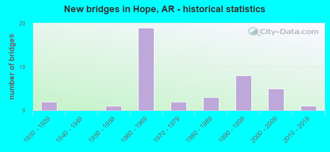
- New bridges - historical statistics
- 21930-1939
- 11950-1959
- 191960-1969
- 21970-1979
- 31980-1989
- 81990-1999
- 52000-2009
- 12010-2019
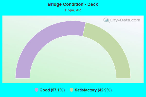
- Bridge Condition - Deck
- 57.1%Good
- 42.9%Satisfactory
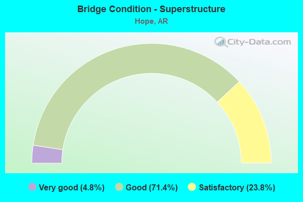
- Bridge Condition - Superstructure
- 4.8%Very good
- 71.4%Good
- 23.8%Satisfactory
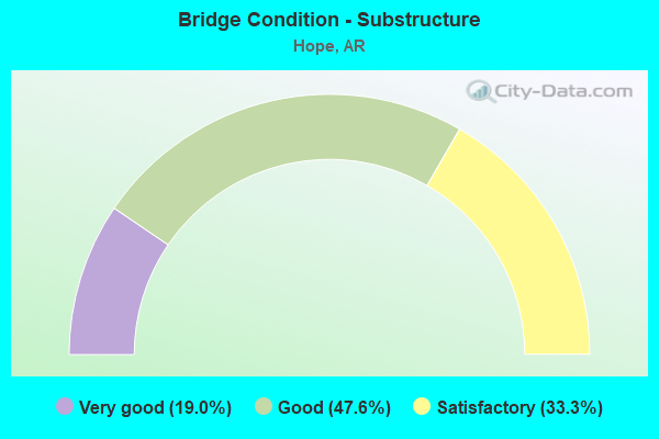
- Bridge Condition - Substructure
- 19.0%Very good
- 47.6%Good
- 33.3%Satisfactory
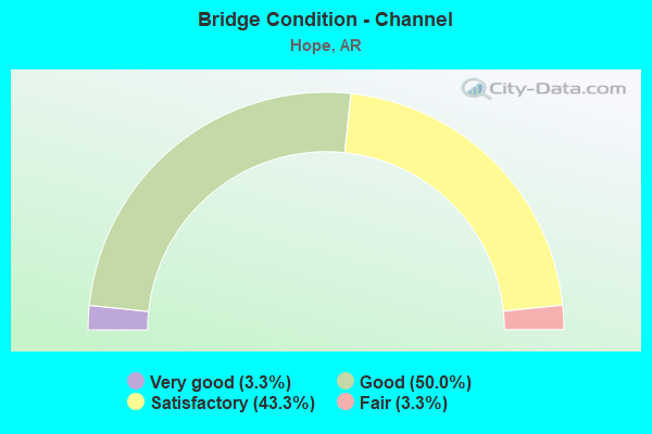
- Bridge Condition - Channel
- 3.3%Very good
- 50.0%Good
- 43.3%Satisfactory
- 3.3%Fair
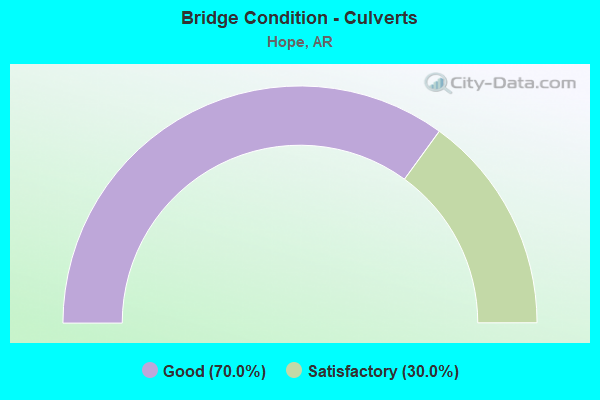
- Bridge Condition - Culverts
- 70.0%Good
- 30.0%Satisfactory
Find on map >> Show street view
Structure Number: 5767, Location: 1.34 MI SE JCT I-30 (Lat: 33.668031, Lng: -93.596925), Route carried "under" structure: Business US 278, Structure Length: 0. m, Average Daily Traffic: 15,000 (year 2014), Truck Traffic: 1%, Features Intersected: US 278 - 5B - 0.99, Facility Carried by Structure: UNION PACIFIC RR
Minimum Vertical Clearance: 4.69m (15.39ft), Kilometerpoint: 1.593, Length of Maximum Span: 0.0m
Find on map >> Show street view
Structure Number: 7061, Location: JCT 278 & I30 HOPE, AR (Lat: 33.682300, Lng: -93.610700), Route carried "under" structure: Interstate 30, Structure Length: 0. m, Average Daily Traffic: 14,000 (year 2013), Truck Traffic: 44%, Features Intersected: I-30 SEC. 12 LM 29.99, Facility Carried by Structure: 278-05-23.95 HEMP.
Minimum Vertical Clearance: 5.15m (16.90ft), Kilometerpoint: 48.264, Length of Maximum Span: 0.0m
Find on map >> Show street view
Structure Number: 7061, Location: JCT 278 & I30 HOPE, AR (Lat: 33.682300, Lng: -93.610700), Route carried "under" structure: Interstate 30, Structure Length: 0. m, Average Daily Traffic: 14,000 (year 2013), Truck Traffic: 44%, Features Intersected: I-30 SEC. 12 LM 29.99, Facility Carried by Structure: 278-05-23.95 HEMP.
Minimum Vertical Clearance: 5.18m (16.99ft), Kilometerpoint: 48.264, Length of Maximum Span: 0.0m
Find on map >> Show street view
Structure Number: A5052, Location: 1.1 MI NE JCT US 278/I-30 (Lat: 33.690889, Lng: -93.598731), Route carried "under" structure: State highway 29, Structure Length: 0. m, Average Daily Traffic: 8,000 (year 2014), Truck Traffic: 44%, Features Intersected: SH 29-SEC 4 L.M. 0.38, Facility Carried by Structure: I30WB LN30.89 HEMP
Minimum Vertical Clearance: 4.92m (16.14ft), Kilometerpoint: 0.612, Length of Maximum Span: 0.0m
Find on map >> Show street view
Structure Number: B5052, Location: 1.0 MI NE JCT US 278/I-30 (Lat: 33.690400, Lng: -93.598500), Route carried "under" structure: State highway 29, Structure Length: 0. m, Average Daily Traffic: 9,800 (year 2014), Truck Traffic: 44%, Features Intersected: SH 29-SEC 4- 0.37, Facility Carried by Structure: I 30-EB LN-30.89
Minimum Vertical Clearance: 4.94m (16.21ft), Kilometerpoint: 0.595, Length of Maximum Span: 0.0m