Bridge Statistics for Huntsville, Texas (TX)
Condition, Traffic, Stress, Structural Evaluation, Project Costs
- National Bridge Inventory (NBI) Statistics
- 102Number of bridges
- 1,010ft / 308mTotal length
- $953,000Total costs
- 1,188,720Total average daily traffic
- 273,486Total average daily truck traffic
- National Bridge Inventory (NBI) Registered Bridges for Huntsville
- No street view available for this location
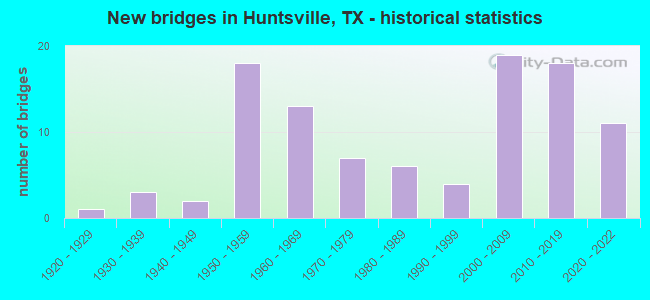
- New bridges - historical statistics
- 11920-1929
- 31930-1939
- 21940-1949
- 181950-1959
- 131960-1969
- 71970-1979
- 61980-1989
- 41990-1999
- 192000-2009
- 182010-2019
- 112020-2022
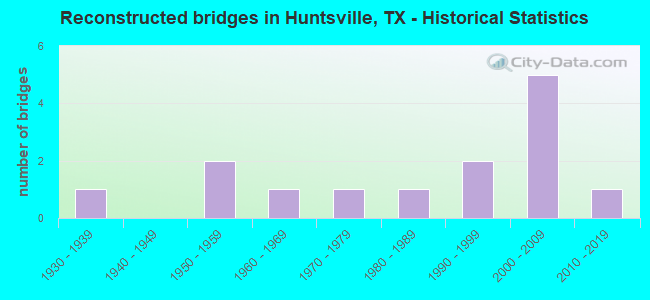
- Reconstructed bridges - Historical Statistics
- 11930-1939
- 01940-1949
- 21950-1959
- 11960-1969
- 11970-1979
- 11980-1989
- 21990-1999
- 52000-2009
- 12010-2019
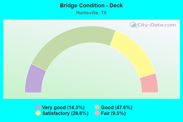
- Bridge Condition - Deck
- 14.3%Very good
- 47.6%Good
- 28.6%Satisfactory
- 9.5%Fair
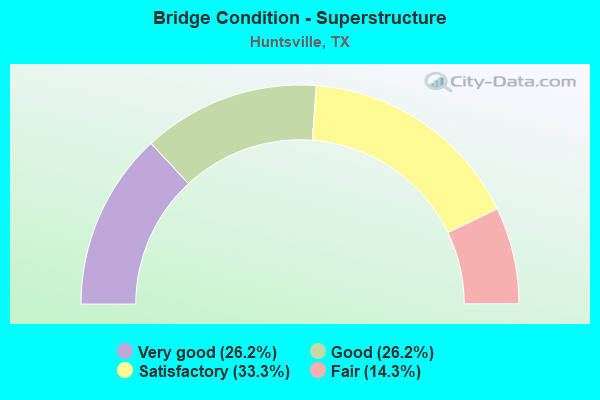
- Bridge Condition - Superstructure
- 26.2%Very good
- 26.2%Good
- 33.3%Satisfactory
- 14.3%Fair
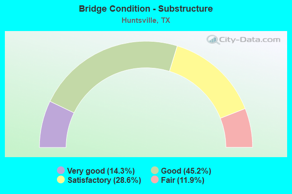
- Bridge Condition - Substructure
- 14.3%Very good
- 45.2%Good
- 28.6%Satisfactory
- 11.9%Fair
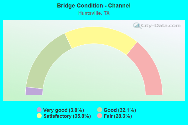
- Bridge Condition - Channel
- 3.8%Very good
- 32.1%Good
- 35.8%Satisfactory
- 28.3%Fair
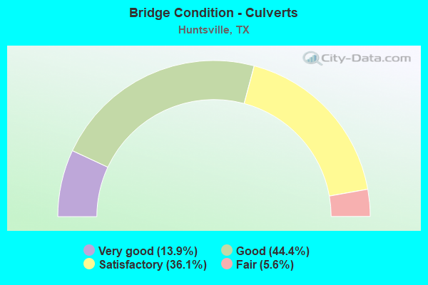
- Bridge Condition - Culverts
- 13.9%Very good
- 44.4%Good
- 36.1%Satisfactory
- 5.6%Fair
Find on map >> Show street view
Structure Number: 172360010909018, Location: 1.65 MI SW OF FM 980 (Lat: 30.833683, Lng: -95.419506), Route carried "on" structure: State highway 19, Year Built: 1930, Year Reconstructed: 1964, Status: Open, Structure Length: 4.02m (13.19ft), Average Daily Traffic: 5,803 (year 2020), Truck Traffic: 14%, Average Future Daily Traffic: 7,380 (year 2033), Features Intersected: CANEY CREEK
Minimum Vertical Clearance: 30+ m (98+ ft), Kilometerpoint: 3.364, Lanes on structure: 2, Base Highway Network: Yes, Owner: State Highway Agency, Approaching Roadway Width: 12.2m (40.0ft), Material/Design: Concrete, Design/Construction: Tee Beam, Number Of Spans In Main Unit: 5, Length of Maximum Span: 8.2m (26.9ft), Curb-To-Curb Width: 13.0m (42.7ft), Out-to-Out Width: 13.9m (45.6ft)
Condition: Deck: Satisfactory, Superstructure: Satisfactory, Substructure: Satisfactory, Channel: Fair, Operating Rating: 44.4 metric tons, Method Used To Determine Operating Rating: Load Factor (LF), Inventory Rating: 32.7 metric tons, Method Used To Determine Inventory Rating: Load Factor (LF), Structural Evaluation: Equal to present minimum criteria, Deck Geometry: Superior to present desirable criteria, Waterway Adequacy: Equal to present minimum criteria, Approach Roadway Alignment: Equal to present desirable criteria, Designated Inspection Frequency: Every 24 months, Inspection Date: July 2021, Deck Structure Type: Concrete Cast-file-Place, Wearing Surface/Protective System: Wearing Surface: Bituminous
Find on map >> Show street view
Structure Number: 172360010909019, Location: 4.25 MI NE OF FM 2821 (Lat: 30.782500, Lng: -95.478747), Route carried "on" structure: State highway 19, Year Built: 1930, Year Reconstructed: 1964, Status: Open, Structure Length: 6.34m (20.80ft), Average Daily Traffic: 8,767 (year 2020), Truck Traffic: 15%, Average Future Daily Traffic: 12,273 (year 2040), Features Intersected: HARMON CREEK
Minimum Vertical Clearance: 30+ m (98+ ft), Kilometerpoint: 11.459, Lanes on structure: 2, Base Highway Network: Yes, Owner: State Highway Agency, Approaching Roadway Width: 13.4m (44.0ft), Material/Design: Concrete, Design/Construction: Tee Beam, Number Of Spans In Main Unit: 6, Number Of Approach Spans: 2, Length of Maximum Span: 8.8m (28.9ft), Curb-To-Curb Width: 13.0m (42.7ft), Out-to-Out Width: 13.9m (45.6ft)
Condition: Deck: Satisfactory, Superstructure: Satisfactory, Substructure: Fair, Channel: Fair, Operating Rating: 44.4 metric tons, Method Used To Determine Operating Rating: Load Factor (LF), Inventory Rating: 27.2 metric tons, Method Used To Determine Inventory Rating: Load Factor (LF), Structural Evaluation: Somewhat better than minimum adequacy, Deck Geometry: Superior to present desirable criteria, Waterway Adequacy: Equal to present minimum criteria, Approach Roadway Alignment: Equal to present desirable criteria, Designated Inspection Frequency: Every 24 months, Inspection Date: July 2021, Deck Structure Type: Concrete Cast-file-Place, Wearing Surface/Protective System: Wearing Surface: Bituminous
Find on map >> Show street view
Structure Number: 172360010909031, Location: 1.00 MI E OF FM 247 (Lat: 30.742447, Lng: -95.532006), Route carried "on" structure: State highway 19, Year Built: 1983, Status: Open, Structure Length: 5.79m (19.00ft), Average Daily Traffic: 8,041 (year 2019), Truck Traffic: 8%, Average Future Daily Traffic: 11,257 (year 2039), Design Load: HS 20, Features Intersected: FM 2821
Minimum Vertical Clearance: 30+ m (98+ ft), Kilometerpoint: 18.400, Lanes on structure: 2, Lanes under structure: 5, Base Highway Network: Yes, Owner: State Highway Agency, Approaching Roadway Width: 12.8m (42.0ft), Skew: 1 degrees, Material/Design: Prestressed concrete, Design/Construction: Stringer/Multi-beam, Number Of Spans In Main Unit: 1, Number Of Approach Spans: 2, Length of Maximum Span: 30.5m (100.1ft), Curb-To-Curb Width: 12.9m (42.3ft), Out-to-Out Width: 13.6m (44.6ft)
Condition: Deck: Good, Superstructure: Good, Substructure: Good, Operating Rating: 54.4 metric tons, Method Used To Determine Operating Rating: Load Factor (LF), Inventory Rating: 32.7 metric tons, Method Used To Determine Inventory Rating: Load Factor (LF), Structural Evaluation: Better than present minimum criteria, Deck Geometry: Superior to present desirable criteria, Underclear: Equal to present minimum criteria, Approach Roadway Alignment: Equal to present desirable criteria, Designated Inspection Frequency: Every 24 months, Inspection Date: July 2021, Deck Structure Type: Concrete Precast Panels, Wearing Surface/Protective System: Wearing Surface: Bituminous
Find on map >> Show street view
Structure Number: 172360010909033, Location: 0.7 MI S OF FM 2821 (Lat: 30.732011, Lng: -95.528603), Route carried "on" structure: State highway 30, Year Built: 1984, Status: Open, Structure Length: 9.30m (30.51ft), Average Daily Traffic: 4,597 (year 2020), Truck Traffic: 12%, Average Future Daily Traffic: 4,597 (year 2040), Design Load: HS 20, Features Intersected: SH 19
Minimum Vertical Clearance: 30+ m (98+ ft), Kilometerpoint: 50.773, Lanes on structure: 3, Lanes under structure: 4, Owner: State Highway Agency, Approaching Roadway Width: 14.6m (47.9ft), Skew: 2 degrees, Material/Design: Prestressed concrete, Design/Construction: Stringer/Multi-beam, Number Of Spans In Main Unit: 2, Number Of Approach Spans: 2, Length of Maximum Span: 27.4m (89.9ft), Curb-To-Curb Width: 14.7m (48.2ft), Out-to-Out Width: 15.3m (50.2ft)
Condition: Deck: Good, Superstructure: Satisfactory, Substructure: Satisfactory, Operating Rating: 54.4 metric tons, Method Used To Determine Operating Rating: Assigned ratings based on Allowable Stress Design (ASD) reported in metric tons, Inventory Rating: 32.7 metric tons, Method Used To Determine Inventory Rating: Assigned ratings based on Allowable Stress Design (ASD) reported in metric tons, Structural Evaluation: Equal to present minimum criteria, Deck Geometry: Somewhat better than minimum adequacy, Underclear: Better than present minimum criteria, Approach Roadway Alignment: Equal to present desirable criteria, Designated Inspection Frequency: Every 24 months, Inspection Date: July 2021, Deck Structure Type: Concrete Precast Panels
Find on map >> Show street view
Structure Number: 172360010909037, Location: 0.5 MI S OF US 190 (Lat: 30.709456, Lng: -95.527436), Route carried "on" structure: State highway 19, Year Built: 1975, Status: Open, Structure Length: 8.84m (29.00ft), Average Daily Traffic: 5,594 (year 2020), Truck Traffic: 8%, Average Future Daily Traffic: 9,078 (year 2039), Design Load: HS 20, Features Intersected: BEARKAT BLVD
Minimum Vertical Clearance: 30+ m (98+ ft), Kilometerpoint: 22.186, Lanes on structure: 2, Lanes under structure: 4, Owner: State Highway Agency, Approaching Roadway Width: 13.4m (44.0ft), Material/Design: Prestressed concrete, Design/Construction: Stringer/Multi-beam, Number Of Spans In Main Unit: 3, Number Of Approach Spans: 2, Length of Maximum Span: 21.3m (69.9ft), Curb-To-Curb Width: 14.6m (47.9ft), Out-to-Out Width: 15.3m (50.2ft)
Condition: Deck: Satisfactory, Superstructure: Good, Substructure: Good, Operating Rating: 54.4 metric tons, Method Used To Determine Operating Rating: Assigned ratings based on Allowable Stress Design (ASD) reported in metric tons, Inventory Rating: 32.7 metric tons, Method Used To Determine Inventory Rating: Assigned ratings based on Allowable Stress Design (ASD) reported in metric tons, Structural Evaluation: Better than present minimum criteria, Deck Geometry: Superior to present desirable criteria, Underclear: Equal to present minimum criteria, Approach Roadway Alignment: Equal to present desirable criteria, Designated Inspection Frequency: Every 24 months, Inspection Date: July 2021, Deck Structure Type: Concrete Cast-file-Place
Find on map >> Show street view
Structure Number: 172360010909044, Location: 4.25 MI NE OF FM 2821 (Lat: 30.782692, Lng: -95.478633), Route carried "on" structure: State highway 19, Year Built: 1990, Status: Open, Structure Length: 6.10m (20.01ft), Average Daily Traffic: 8,767 (year 2020), Truck Traffic: 15%, Average Future Daily Traffic: 12,273 (year 2040), Design Load: HS 20, Features Intersected: HARMON CREEK
Minimum Vertical Clearance: 30+ m (98+ ft), Kilometerpoint: 11.459, Lanes on structure: 2, Base Highway Network: Yes, Owner: State Highway Agency, Approaching Roadway Width: 11.6m (38.1ft), Material/Design: Concrete, Design/Construction: Stringer/Multi-beam, Number Of Spans In Main Unit: 5, Length of Maximum Span: 12.2m (40.0ft), Curb-To-Curb Width: 11.7m (38.4ft), Out-to-Out Width: 12.3m (40.4ft)
Condition: Deck: Satisfactory, Superstructure: Good, Substructure: Satisfactory, Channel: Good, Operating Rating: 54.4 metric tons, Method Used To Determine Operating Rating: Load Factor (LF), Inventory Rating: 32.7 metric tons, Method Used To Determine Inventory Rating: Load Factor (LF), Structural Evaluation: Equal to present minimum criteria, Deck Geometry: Better than present minimum criteria, Waterway Adequacy: Equal to present minimum criteria, Approach Roadway Alignment: Equal to present desirable criteria, Designated Inspection Frequency: Every 24 months, Inspection Date: July 2021, Deck Structure Type: Concrete Cast-file-Place, Wearing Surface/Protective System: Wearing Surface: Bituminous
Find on map >> Show street view
Structure Number: 172360010909051, Location: 1.02 MI E OF FM 247 (Lat: 30.741928, Lng: -95.531761), Route carried "on" structure: State highway 19, Year Built: 2005, Status: Open, Structure Length: 5.79m (19.00ft), Average Daily Traffic: 7,685 (year 2020), Truck Traffic: 8%, Average Future Daily Traffic: 11,257 (year 2039), Design Load: HS 20, Features Intersected: FM 2821
Minimum Vertical Clearance: 30+ m (98+ ft), Kilometerpoint: 18.400, Lanes on structure: 2, Lanes under structure: 5, Base Highway Network: Yes, Owner: State Highway Agency, Approaching Roadway Width: 11.3m (37.1ft), Skew: 1 degrees, Material/Design: Prestressed concrete, Design/Construction: Stringer/Multi-beam, Number Of Spans In Main Unit: 1, Number Of Approach Spans: 2, Length of Maximum Span: 30.5m (100.1ft), Curb-To-Curb Width: 11.4m (37.4ft), Out-to-Out Width: 12.0m (39.4ft)
Condition: Deck: Good, Superstructure: Good, Substructure: Good, Operating Rating: 54.4 metric tons, Method Used To Determine Operating Rating: Assigned rating based on Load Factor Design (LFD) reported in metric tons, Inventory Rating: 32.7 metric tons, Method Used To Determine Inventory Rating: Assigned rating based on Load Factor Design (LFD) reported in metric tons, Structural Evaluation: Better than present minimum criteria, Deck Geometry: Equal to present minimum criteria, Underclear: Equal to present minimum criteria, Approach Roadway Alignment: Equal to present desirable criteria, Designated Inspection Frequency: Every 24 months, Inspection Date: July 2021, Deck Structure Type: Concrete Precast Panels
Find on map >> Show street view
Structure Number: 172360010909097, Location: 1.46 MI S OF US 190 (Lat: 30.695592, Lng: -95.531783), Route carried "on" structure: State highway 19, Year Built: 1979, Status: Open, Structure Length: 6.40m (21.00ft), Average Daily Traffic: 7,883 (year 2020), Truck Traffic: 16%, Average Future Daily Traffic: 11,036 (year 2040), Design Load: HS 20, Features Intersected: SH 75
Minimum Vertical Clearance: 30+ m (98+ ft), Kilometerpoint: 23.751, Lanes on structure: 2, Lanes under structure: 5, Base Highway Network: Yes, Owner: State Highway Agency, Approaching Roadway Width: 12.8m (42.0ft), Skew: 4 degrees, Material/Design: Prestressed concrete, Design/Construction: Stringer/Multi-beam, Number Of Spans In Main Unit: 1, Number Of Approach Spans: 2, Length of Maximum Span: 36.6m (120.1ft), Curb-To-Curb Width: 12.9m (42.3ft), Out-to-Out Width: 13.5m (44.3ft)
Condition: Deck: Satisfactory, Superstructure: Fair, Substructure: Fair, Operating Rating: 54.4 metric tons, Method Used To Determine Operating Rating: Load Factor (LF), Inventory Rating: 29.0 metric tons, Method Used To Determine Inventory Rating: Load Factor (LF), Structural Evaluation: Somewhat better than minimum adequacy, Deck Geometry: Superior to present desirable criteria, Underclear: Meets minimum limits, Approach Roadway Alignment: Equal to present desirable criteria, Designated Inspection Frequency: Every 24 months, Inspection Date: July 2021, Deck Structure Type: Concrete Cast-file-Place
Find on map >> Show street view
Structure Number: 172360010909206, Location: 1.46 MI S OF US 190 (Lat: 30.695433, Lng: -95.531581), Route carried "on" structure: State highway 19, Year Built: 2012, Status: Open, Structure Length: 6.40m (21.00ft), Average Daily Traffic: 3,712 (year 2020), Truck Traffic: 8%, Average Future Daily Traffic: 7,872 (year 2039), Design Load: HL 93, Features Intersected: SH 75
Minimum Vertical Clearance: 30+ m (98+ ft), Kilometerpoint: 23.751, Lanes on structure: 2, Lanes under structure: 5, Base Highway Network: Yes, Owner: State Highway Agency, Approaching Roadway Width: 11.6m (38.1ft), Skew: 4 degrees, Material/Design: Prestressed concrete, Design/Construction: Stringer/Multi-beam, Number Of Spans In Main Unit: 1, Number Of Approach Spans: 2, Length of Maximum Span: 36.6m (120.1ft), Curb-To-Curb Width: 11.2m (36.7ft), Out-to-Out Width: 12.2m (40.0ft)
Condition: Deck: Good, Superstructure: Very good, Substructure: Good, Operating Rating: 54.4 metric tons, Method Used To Determine Operating Rating: Assigned ratings based on Load and Resistance Factor Design (LRFD) reported in metric tons, Inventory Rating: 32.7 metric tons, Method Used To Determine Inventory Rating: Assigned ratings based on Load and Resistance Factor Design (LRFD) reported in metric tons, Structural Evaluation: Better than present minimum criteria, Deck Geometry: Equal to present minimum criteria, Underclear: Meets minimum limits, Approach Roadway Alignment: Equal to present desirable criteria, Designated Inspection Frequency: Every 24 months, Inspection Date: July 2021, Deck Structure Type: Concrete Cast-file-Place
Find on map >> Show street view
Structure Number: 172360010909207, Location: 0.5 MI S OF US 190 (Lat: 30.708883, Lng: -95.527367), Route carried "on" structure: State highway 19, Year Built: 2012, Status: Open, Structure Length: 8.84m (29.00ft), Average Daily Traffic: 5,322 (year 2020), Truck Traffic: 8%, Average Future Daily Traffic: 9,078 (year 2039), Design Load: HL 93, Features Intersected: BEARKAT BLVD
Minimum Vertical Clearance: 30+ m (98+ ft), Kilometerpoint: 22.186, Lanes on structure: 2, Lanes under structure: 4, Owner: State Highway Agency, Approaching Roadway Width: 11.6m (38.1ft), Material/Design: Prestressed concrete, Design/Construction: Stringer/Multi-beam, Number Of Spans In Main Unit: 2, Number Of Approach Spans: 1, Length of Maximum Span: 38.1m (125.0ft), Curb-To-Curb Width: 11.2m (36.7ft), Out-to-Out Width: 12.2m (40.0ft)
Condition: Deck: Good, Superstructure: Good, Substructure: Good, Operating Rating: 54.4 metric tons, Method Used To Determine Operating Rating: Assigned ratings based on Load and Resistance Factor Design (LRFD) reported in metric tons, Inventory Rating: 32.7 metric tons, Method Used To Determine Inventory Rating: Assigned ratings based on Load and Resistance Factor Design (LRFD) reported in metric tons, Structural Evaluation: Better than present minimum criteria, Deck Geometry: Equal to present minimum criteria, Underclear: Equal to present minimum criteria, Approach Roadway Alignment: Equal to present desirable criteria, Designated Inspection Frequency: Every 24 months, Inspection Date: July 2021, Deck Structure Type: Concrete Cast-file-Place
Find on map >> Show street view
Structure Number: 172360016608043, Location: 1.15 MI NW OF FM 1696 (Lat: 30.764214, Lng: -95.664517), Route carried "on" structure: State highway 75, Year Built: 1927, Year Reconstructed: 1941, Status: Open, Structure Length: 1.07m (3.51ft), Average Daily Traffic: 2,315 (year 2020), Truck Traffic: 36%, Average Future Daily Traffic: 1,225 (year 2039), Design Load: H 15, Features Intersected: ROCKY CREEK
Minimum Vertical Clearance: 30+ m (98+ ft), Kilometerpoint: 17.127, Lanes on structure: 2, Base Highway Network: Yes, Owner: State Highway Agency, Approaching Roadway Width: 7.3m (24.0ft), Material/Design: Concrete, Design/Construction: Culvert, Number Of Spans In Main Unit: 4, Length of Maximum Span: 2.4m (7.9ft), Curb-To-Curb Width: 11.0m (36.1ft), Out-to-Out Width: 12.0m (39.4ft)
Condition: Channel: Satisfactory, Culverts: Fair, Operating Rating: 39.9 metric tons, Method Used To Determine Operating Rating: Load Factor (LF), Inventory Rating: 23.6 metric tons, Method Used To Determine Inventory Rating: Load Factor (LF), Structural Evaluation: Somewhat better than minimum adequacy, Deck Geometry: Somewhat better than minimum adequacy, Waterway Adequacy: Equal to present minimum criteria, Approach Roadway Alignment: Equal to present desirable criteria, Designated Inspection Frequency: Every 24 months, Inspection Date: July 2021, Deck Structure Type: Concrete Cast-file-Place, Wearing Surface/Protective System: Wearing Surface: Bituminous
Find on map >> Show street view
Structure Number: 17236002120201, Location: 0.3 MI E OF FM 2550 (Lat: 30.688656, Lng: -95.681706), Route carried "on" structure: State highway 30, Year Built: 1955, Year Reconstructed: 1968, Status: Open, Structure Length: 6.71m (22.01ft), Average Daily Traffic: 8,055 (year 2020), Truck Traffic: 6%, Average Future Daily Traffic: 16,240 (year 2033), Features Intersected: MCGARY CREEK
Minimum Vertical Clearance: 30+ m (98+ ft), Kilometerpoint: 15.149, Lanes on structure: 2, Base Highway Network: Yes, Owner: State Highway Agency, Approaching Roadway Width: 13.4m (44.0ft), Material/Design: Concrete continuous, Design/Construction: Slab, Number Of Spans In Main Unit: 8, Length of Maximum Span: 9.1m (29.9ft), Curb-To-Curb Width: 14.6m (47.9ft), Out-to-Out Width: 15.4m (50.5ft)
Condition: Deck: Good, Superstructure: Good, Substructure: Fair, Channel: Fair, Operating Rating: 39.0 metric tons, Method Used To Determine Operating Rating: Load Factor (LF), Inventory Rating: 23.6 metric tons, Method Used To Determine Inventory Rating: Load Factor (LF), Structural Evaluation: Somewhat better than minimum adequacy, Deck Geometry: Superior to present desirable criteria, Waterway Adequacy: Equal to present minimum criteria, Approach Roadway Alignment: Equal to present desirable criteria, Length Of Structure Improvement: 7.71m (25.30ft), Designated Inspection Frequency: Every 24 months, Inspection Date: July 2021, Bridge Improvement Cost: $391,000, Roadway Improvement Cost: $98,000, Total Project Cost: $489,000, Deck Structure Type: Concrete Cast-file-Place, Wearing Surface/Protective System: Wearing Surface: Bituminous
Find on map >> Show street view
Structure Number: 172360021202215, Location: 2.55 MI SW OF IH 45 (Lat: 30.704453, Lng: -95.608706), Route carried "on" structure: State highway 1791, Year Built: 2014, Status: Open, Structure Length: 2.83m (9.28ft), Average Daily Traffic: 3,586 (year 2019), Truck Traffic: 5%, Average Future Daily Traffic: 4,303 (year 2039), Design Load: HL 93, Features Intersected: SH 30
Minimum Vertical Clearance: 5.08m (16.67ft), Kilometerpoint: 0.021, Lanes on structure: 6, Lanes under structure: 4, Owner: State Highway Agency, Approaching Roadway Width: 43.6m (143.0ft), Skew: 20 degrees, Material/Design: Prestressed concrete, Design/Construction: Stringer/Multi-beam, Number Of Spans In Main Unit: 1, Length of Maximum Span: 28.3m (92.8ft), Curb or Sidewalk Widths: Left: 1.5m (4.9ft), Right: 1.5m (4.9ft), Curb-To-Curb Width: 44.1m (144.7ft), Out-to-Out Width: 91.4m (299.9ft)
Condition: Deck: Good, Superstructure: Very good, Substructure: Good, Operating Rating: 54.4 metric tons, Method Used To Determine Operating Rating: Assigned ratings based on Load and Resistance Factor Design (LRFD) reported in metric tons, Inventory Rating: 32.7 metric tons, Method Used To Determine Inventory Rating: Assigned ratings based on Load and Resistance Factor Design (LRFD) reported in metric tons, Structural Evaluation: Better than present minimum criteria, Deck Geometry: Superior to present desirable criteria, Underclear: Somewhat better than minimum adequacy, Approach Roadway Alignment: Equal to present desirable criteria, Designated Inspection Frequency: Every 24 months, Inspection Date: July 2021, Deck Structure Type: Concrete Cast-file-Place
Find on map >> Show street view
Structure Number: 172360021301035, Location: 1.15 MI S OF SH 30 (Lat: 30.716086, Lng: -95.525653), Route carried "on" structure: Business State highway 19, Year Built: 1977, Status: Open, Structure Length: 6.25m (20.51ft), Average Daily Traffic: 7,520 (year 2020), Truck Traffic: 16%, Average Future Daily Traffic: 10,528 (year 2040), Design Load: HS 20, Features Intersected: US 190
Minimum Vertical Clearance: 6.25m (20.51ft), Kilometerpoint: 21.420, Lanes on structure: 2, Lanes under structure: 5, Base Highway Network: Yes, Owner: State Highway Agency, Approaching Roadway Width: 14.6m (47.9ft), Skew: 3 degrees, Material/Design: Prestressed concrete, Design/Construction: Stringer/Multi-beam, Number Of Spans In Main Unit: 1, Number Of Approach Spans: 2, Length of Maximum Span: 32.0m (105.0ft), Curb-To-Curb Width: 14.7m (48.2ft), Out-to-Out Width: 15.3m (50.2ft)
Condition: Deck: Good, Superstructure: Good, Substructure: Good, Operating Rating: 54.4 metric tons, Method Used To Determine Operating Rating: Load Factor (LF), Inventory Rating: 25.4 metric tons, Method Used To Determine Inventory Rating: Load Factor (LF), Structural Evaluation: Equal to present minimum criteria, Deck Geometry: Superior to present desirable criteria, Underclear: Meets minimum limits, Approach Roadway Alignment: Equal to present desirable criteria, Designated Inspection Frequency: Every 24 months, Inspection Date: July 2021, Deck Structure Type: Concrete Cast-file-Place
Find on map >> Show street view
Structure Number: 172360021301111, Location: 1.15 MI S OF SH 30 (Lat: 30.715972, Lng: -95.525294), Route carried "on" structure: State highway 19, Year Built: 2012, Status: Open, Structure Length: 6.25m (20.51ft), Average Daily Traffic: 7,358 (year 2019), Truck Traffic: 8%, Average Future Daily Traffic: 8,830 (year 2039), Design Load: HL 93, Features Intersected: US 190
Minimum Vertical Clearance: 5.79m (19.00ft), Kilometerpoint: 21.420, Lanes on structure: 2, Lanes under structure: 5, Base Highway Network: Yes, Owner: State Highway Agency, Approaching Roadway Width: 11.6m (38.1ft), Skew: 3 degrees, Material/Design: Prestressed concrete, Design/Construction: Stringer/Multi-beam, Number Of Spans In Main Unit: 1, Number Of Approach Spans: 2, Length of Maximum Span: 32.0m (105.0ft), Curb-To-Curb Width: 11.2m (36.7ft), Out-to-Out Width: 12.2m (40.0ft)
Condition: Deck: Good, Superstructure: Very good, Substructure: Good, Operating Rating: 54.4 metric tons, Method Used To Determine Operating Rating: Assigned ratings based on Load and Resistance Factor Design (LRFD) reported in metric tons, Inventory Rating: 32.7 metric tons, Method Used To Determine Inventory Rating: Assigned ratings based on Load and Resistance Factor Design (LRFD) reported in metric tons, Structural Evaluation: Better than present minimum criteria, Deck Geometry: Equal to present minimum criteria, Underclear: Meets minimum limits, Approach Roadway Alignment: Equal to present desirable criteria, Designated Inspection Frequency: Every 24 months, Inspection Date: July 2021, Deck Structure Type: Concrete Cast-file-Place
Find on map >> Show street view
Structure Number: 172360057802006, Location: 0.1 MI S OF FM 980 (Lat: 30.752472, Lng: -95.549622), Route carried "on" structure: State highway 247, Year Built: 1948, Year Reconstructed: 1988, Status: Open, Structure Length: 1.01m (3.31ft), Average Daily Traffic: 7,873 (year 2020), Truck Traffic: 4%, Average Future Daily Traffic: 11,022 (year 2040), Design Load: H 15, Features Intersected: PARKER CREEK
Minimum Vertical Clearance: 30+ m (98+ ft), Kilometerpoint: 22.322, Lanes on structure: 4, Owner: State Highway Agency, Approaching Roadway Width: 15.5m (50.9ft), Skew: 9 degrees, Material/Design: Concrete, Design/Construction: Culvert, Number Of Spans In Main Unit: 4, Length of Maximum Span: 1.8m (5.9ft)
Condition: Channel: Fair, Culverts: Satisfactory, Operating Rating: 39.9 metric tons, Method Used To Determine Operating Rating: Load Factor (LF), Inventory Rating: 23.6 metric tons, Method Used To Determine Inventory Rating: Load Factor (LF), Structural Evaluation: Somewhat better than minimum adequacy, Waterway Adequacy: Equal to present minimum criteria, Approach Roadway Alignment: Equal to present desirable criteria, Designated Inspection Frequency: Every 24 months, Inspection Date: July 2021
Find on map >> Show street view
Structure Number: 172360057802021, Location: 0.25 MI N OF FM 2821 (Lat: 30.745353, Lng: -95.548914), Route carried "on" structure: State highway 247, Year Built: 1977, Status: Open, Structure Length: 1.34m (4.40ft), Average Daily Traffic: 7,873 (year 2020), Truck Traffic: 4%, Average Future Daily Traffic: 11,022 (year 2040), Design Load: HS 20, Features Intersected: ROMAN CREEK(TOWN BRANCH)
Minimum Vertical Clearance: 30+ m (98+ ft), Kilometerpoint: 23.092, Lanes on structure: 4, Owner: State Highway Agency, Approaching Roadway Width: 15.5m (50.9ft), Skew: 1 degrees, Material/Design: Concrete, Design/Construction: Culvert, Number Of Spans In Main Unit: 4, Length of Maximum Span: 3.0m (9.8ft)
Condition: Channel: Fair, Culverts: Satisfactory, Operating Rating: 39.9 metric tons, Method Used To Determine Operating Rating: Load Factor (LF), Inventory Rating: 23.6 metric tons, Method Used To Determine Inventory Rating: Load Factor (LF), Structural Evaluation: Somewhat better than minimum adequacy, Waterway Adequacy: Equal to present minimum criteria, Approach Roadway Alignment: Equal to present desirable criteria, Designated Inspection Frequency: Every 24 months, Inspection Date: July 2021
Find on map >> Show street view
Structure Number: 172360057803012, Location: 5.05 MI NW OF IH 45 (Lat: 30.584053, Lng: -95.566128), Route carried "on" structure: State highway 1374, Year Built: 1956, Status: Open, Structure Length: 3.81m (12.50ft), Average Daily Traffic: 896 (year 2020), Truck Traffic: 11%, Average Future Daily Traffic: 1,188 (year 2039), Features Intersected: EAST SANDY CREEK
Minimum Vertical Clearance: 30+ m (98+ ft), Kilometerpoint: 21.140, Lanes on structure: 2, Owner: State Highway Agency, Approaching Roadway Width: 7.6m (24.9ft), Material/Design: Concrete, Design/Construction: Slab, Number Of Spans In Main Unit: 5, Length of Maximum Span: 7.6m (24.9ft), Curb-To-Curb Width: 7.1m (23.3ft), Out-to-Out Width: 7.7m (25.3ft)
Condition: Deck: Satisfactory, Superstructure: Satisfactory, Substructure: Good, Channel: Satisfactory, Operating Rating: 44.4 metric tons, Method Used To Determine Operating Rating: Load Factor (LF), Inventory Rating: 25.4 metric tons, Method Used To Determine Inventory Rating: Load Factor (LF), Structural Evaluation: Equal to present minimum criteria, Deck Geometry: Meets minimum limits, Waterway Adequacy: Equal to present minimum criteria, Approach Roadway Alignment: Equal to present desirable criteria, Length Of Structure Improvement: 3.81m (12.50ft), Designated Inspection Frequency: Every 24 months, Inspection Date: July 2021, Bridge Improvement Cost: $6,000, Roadway Improvement Cost: $2,000, Total Project Cost: $8,000, Deck Structure Type: Concrete Cast-file-Place, Wearing Surface/Protective System: Wearing Surface: Bituminous
Find on map >> Show street view
Structure Number: 172360067506004, Location: 1.45 MI NW OF SH 30 (Lat: 30.734181, Lng: -95.585683), Route carried "on" structure: Interstate 45, Year Built: 1959, Year Reconstructed: 2012, Status: Open, Structure Length: 1.59m (5.22ft), Average Daily Traffic: 32,729 (year 2020), Truck Traffic: 39%, Average Future Daily Traffic: 67,319 (year 2039), Features Intersected: MCGARY CREEK
Minimum Vertical Clearance: 30+ m (98+ ft), Kilometerpoint: 28.083, Lanes on structure: 9, Base Highway Network: Yes, Owner: State Highway Agency, Approaching Roadway Width: 46.3m (151.9ft), Skew: 24 degrees, Material/Design: Concrete, Design/Construction: Culvert, Number Of Spans In Main Unit: 4, Length of Maximum Span: 2.7m (8.9ft)
Condition: Channel: Satisfactory, Culverts: Satisfactory, Operating Rating: 39.9 metric tons, Method Used To Determine Operating Rating: Load Factor (LF), Inventory Rating: 23.6 metric tons, Method Used To Determine Inventory Rating: Load Factor (LF), Structural Evaluation: Somewhat better than minimum adequacy, Waterway Adequacy: Equal to present minimum criteria, Approach Roadway Alignment: Equal to present desirable criteria, Designated Inspection Frequency: Every 24 months, Inspection Date: July 2021
Find on map >> Show street view
Structure Number: 17236006750605, Location: 1.5 MI NW OF FM 1696 (Lat: 30.789864, Lng: -95.669664), Route carried "on" structure: ServiceInterstate 45, Year Built: 1962, Status: Open, Structure Length: 3.35m (10.99ft), Average Daily Traffic: 42 (year 2019), Truck Traffic: 7%, Average Future Daily Traffic: 59 (year 2039), Features Intersected: NELSON CREEK
Minimum Vertical Clearance: 30+ m (98+ ft), Kilometerpoint: 38.219, Lanes on structure: 2, Owner: State Highway Agency, Approaching Roadway Width: 6.1m (20.0ft), Material/Design: Concrete continuous, Design/Construction: Slab, Number Of Spans In Main Unit: 4, Length of Maximum Span: 9.1m (29.9ft), Curb-To-Curb Width: 7.5m (24.6ft), Out-to-Out Width: 8.4m (27.6ft)
Condition: Deck: Satisfactory, Superstructure: Satisfactory, Substructure: Satisfactory, Channel: Satisfactory, Operating Rating: 44.4 metric tons, Method Used To Determine Operating Rating: Load Factor (LF), Inventory Rating: 30.8 metric tons, Method Used To Determine Inventory Rating: Load Factor (LF), Structural Evaluation: Equal to present minimum criteria, Deck Geometry: Equal to present minimum criteria, Waterway Adequacy: High priority of corrective action, Approach Roadway Alignment: Equal to present desirable criteria, Length Of Structure Improvement: 3.35m (10.99ft), Designated Inspection Frequency: Every 24 months, Inspection Date: July 2021, Bridge Improvement Cost: $6,000, Roadway Improvement Cost: $2,000, Total Project Cost: $8,000, Deck Structure Type: Concrete Cast-file-Place
Find on map >> Show street view
Structure Number: 172360067506051, Location: 1.5 MI NW OF FM 1696 (Lat: 30.789789, Lng: -95.670683), Route carried "on" structure: Interstate 45, Year Built: 1962, Status: Open, Structure Length: 8.32m (27.30ft), Average Daily Traffic: 16,254 (year 2020), Truck Traffic: 31%, Average Future Daily Traffic: 32,507 (year 2040), Design Load: HS 20, Features Intersected: NELSON CREEK
Minimum Vertical Clearance: 30+ m (98+ ft), Kilometerpoint: 38.219, Lanes on structure: 2, Base Highway Network: Yes, Owner: State Highway Agency, Approaching Roadway Width: 12.2m (40.0ft), Material/Design: Concrete, Design/Construction: Stringer/Multi-beam, Number Of Spans In Main Unit: 9, Length of Maximum Span: 9.1m (29.9ft), Curb-To-Curb Width: 12.2m (40.0ft), Out-to-Out Width: 13.0m (42.7ft)
Condition: Deck: Satisfactory, Superstructure: Satisfactory, Substructure: Satisfactory, Channel: Satisfactory, Operating Rating: 54.4 metric tons, Method Used To Determine Operating Rating: Load Factor (LF), Inventory Rating: 32.7 metric tons, Method Used To Determine Inventory Rating: Load Factor (LF), Structural Evaluation: Equal to present minimum criteria, Deck Geometry: Better than present minimum criteria, Waterway Adequacy: Equal to present minimum criteria, Approach Roadway Alignment: Equal to present desirable criteria, Designated Inspection Frequency: Every 24 months, Inspection Date: July 2021, Deck Structure Type: Concrete Cast-file-Place, Wearing Surface/Protective System: Wearing Surface: Bituminous
Find on map >> Show street view
Structure Number: 172360067506052, Location: 1.5 MI NW OF FM 1696 (Lat: 30.789550, Lng: -95.669786), Route carried "on" structure: Interstate 45, Year Built: 1962, Status: Open, Structure Length: 8.32m (27.30ft), Average Daily Traffic: 16,254 (year 2020), Truck Traffic: 31%, Average Future Daily Traffic: 32,507 (year 2040), Design Load: HS 20, Features Intersected: NELSON CREEK
Minimum Vertical Clearance: 30+ m (98+ ft), Kilometerpoint: 38.219, Lanes on structure: 2, Base Highway Network: Yes, Owner: State Highway Agency, Approaching Roadway Width: 12.2m (40.0ft), Material/Design: Concrete, Design/Construction: Stringer/Multi-beam, Number Of Spans In Main Unit: 9, Length of Maximum Span: 9.1m (29.9ft), Curb-To-Curb Width: 12.2m (40.0ft), Out-to-Out Width: 13.0m (42.7ft)
Condition: Deck: Fair, Superstructure: Fair, Substructure: Satisfactory, Channel: Good, Operating Rating: 54.4 metric tons, Method Used To Determine Operating Rating: Load Factor (LF), Inventory Rating: 32.7 metric tons, Method Used To Determine Inventory Rating: Load Factor (LF), Structural Evaluation: Somewhat better than minimum adequacy, Deck Geometry: Better than present minimum criteria, Waterway Adequacy: Equal to present minimum criteria, Approach Roadway Alignment: Equal to present desirable criteria, Designated Inspection Frequency: Every 24 months, Inspection Date: July 2021, Deck Structure Type: Concrete Cast-file-Place
Find on map >> Show street view
Structure Number: 172360067506053, Location: 1.45 MI N OF SH 75 (Lat: 30.776583, Lng: -95.650103), Route carried "on" structure: Interstate 45, Year Built: 1962, Status: Open, Structure Length: 3.96m (12.99ft), Average Daily Traffic: 17,386 (year 2020), Truck Traffic: 30%, Average Future Daily Traffic: 34,771 (year 2040), Design Load: HS 20, Features Intersected: FM 1696
Minimum Vertical Clearance: 4.88m (16.01ft), Kilometerpoint: 35.822, Lanes on structure: 2, Lanes under structure: 2, Base Highway Network: Yes, Owner: State Highway Agency, Approaching Roadway Width: 11.9m (39.0ft), Material/Design: Concrete continuous, Design/Construction: Slab, Number Of Spans In Main Unit: 3, Length of Maximum Span: 15.2m (49.9ft), Curb-To-Curb Width: 11.9m (39.0ft), Out-to-Out Width: 12.9m (42.3ft)
Condition: Deck: Fair, Superstructure: Fair, Substructure: Good, Operating Rating: 54.4 metric tons, Method Used To Determine Operating Rating: Load Factor (LF), Inventory Rating: 32.7 metric tons, Method Used To Determine Inventory Rating: Load Factor (LF), Structural Evaluation: Somewhat better than minimum adequacy, Deck Geometry: Equal to present minimum criteria, Underclear: Better than present minimum criteria, Approach Roadway Alignment: Equal to present desirable criteria, Designated Inspection Frequency: Every 24 months, Inspection Date: July 2021, Deck Structure Type: Concrete Cast-file-Place
Find on map >> Show street view
Structure Number: 172360067506054, Location: 1.45 MI N OF SH 75 (Lat: 30.776722, Lng: -95.649994), Route carried "on" structure: Interstate 45, Year Built: 1962, Status: Open, Structure Length: 3.96m (12.99ft), Average Daily Traffic: 17,386 (year 2020), Truck Traffic: 30%, Average Future Daily Traffic: 34,771 (year 2040), Design Load: HS 20, Features Intersected: FM 1696
Minimum Vertical Clearance: 5.08m (16.67ft), Kilometerpoint: 35.822, Lanes on structure: 2, Lanes under structure: 2, Base Highway Network: Yes, Owner: State Highway Agency, Approaching Roadway Width: 11.9m (39.0ft), Material/Design: Concrete continuous, Design/Construction: Slab, Number Of Spans In Main Unit: 3, Length of Maximum Span: 15.2m (49.9ft), Curb-To-Curb Width: 11.9m (39.0ft), Out-to-Out Width: 12.9m (42.3ft)
Condition: Deck: Fair, Superstructure: Fair, Substructure: Good, Operating Rating: 54.4 metric tons, Method Used To Determine Operating Rating: Load Factor (LF), Inventory Rating: 32.7 metric tons, Method Used To Determine Inventory Rating: Load Factor (LF), Structural Evaluation: Somewhat better than minimum adequacy, Deck Geometry: Equal to present minimum criteria, Underclear: Better than present minimum criteria, Approach Roadway Alignment: Equal to present desirable criteria, Designated Inspection Frequency: Every 24 months, Inspection Date: July 2021, Deck Structure Type: Concrete Cast-file-Place
Find on map >> Show street view
Structure Number: 172360067506055, Location: 0.75 MI SE OF FM 1696 (Lat: 30.770086, Lng: -95.640083), Route carried "on" structure: Interstate 45, Year Built: 1962, Status: Open, Structure Length: 0.64m (2.10ft), Average Daily Traffic: 34,771 (year 2020), Truck Traffic: 3%, Average Future Daily Traffic: 65,542 (year 2039), Features Intersected: CRABB CREEK
Minimum Vertical Clearance: 30+ m (98+ ft), Kilometerpoint: 34.635, Lanes on structure: 4, Base Highway Network: Yes, Owner: State Highway Agency, Approaching Roadway Width: 25.6m (84.0ft), Skew: 20 degrees, Material/Design: Concrete, Design/Construction: Culvert, Number Of Spans In Main Unit: 2, Length of Maximum Span: 3.0m (9.8ft)
Condition: Channel: Satisfactory, Culverts: Satisfactory, Operating Rating: 39.9 metric tons, Method Used To Determine Operating Rating: Load Factor (LF), Inventory Rating: 23.6 metric tons, Method Used To Determine Inventory Rating: Load Factor (LF), Structural Evaluation: Somewhat better than minimum adequacy, Waterway Adequacy: Superior to present desirable criteria, Approach Roadway Alignment: Equal to present desirable criteria, Designated Inspection Frequency: Every 24 months, Inspection Date: July 2021
Find on map >> Show street view
Structure Number: 172360067506056, Location: 1.25 MI SE OF FM 1696 (Lat: 30.765644, Lng: -95.633400), Route carried "on" structure: Interstate 45, Year Built: 1962, Year Reconstructed: 1982, Status: Open, Structure Length: 0.88m (2.89ft), Average Daily Traffic: 34,771 (year 2020), Truck Traffic: 38%, Average Future Daily Traffic: 55,954 (year 2039), Design Load: H 20, Features Intersected: DRAW
Minimum Vertical Clearance: 30+ m (98+ ft), Kilometerpoint: 33.869, Lanes on structure: 4, Base Highway Network: Yes, Owner: State Highway Agency, Approaching Roadway Width: 25.6m (84.0ft), Skew: 24 degrees, Material/Design: Concrete, Design/Construction: Culvert, Number Of Spans In Main Unit: 2, Length of Maximum Span: 3.0m (9.8ft)
Condition: Channel: Satisfactory, Culverts: Fair, Operating Rating: 39.9 metric tons, Method Used To Determine Operating Rating: Load Factor (LF), Inventory Rating: 23.6 metric tons, Method Used To Determine Inventory Rating: Load Factor (LF), Structural Evaluation: Somewhat better than minimum adequacy, Waterway Adequacy: Equal to present minimum criteria, Approach Roadway Alignment: Equal to present desirable criteria, Designated Inspection Frequency: Every 24 months, Inspection Date: July 2021
Find on map >> Show street view
Structure Number: 172360067506194, Location: 1.85 MI NW OF FM 1374 N (Lat: 30.718242, Lng: -95.569961), Route carried "on" structure: State highway 30, Year Built: 1968, Year Reconstructed: 2002, Status: Open, Structure Length: 8.84m (29.00ft), Average Daily Traffic: 23,037 (year 2020), Truck Traffic: 5%, Average Future Daily Traffic: 37,859 (year 2039), Design Load: HS 20, Features Intersected: IH 45
Minimum Vertical Clearance: 4.98m (16.34ft), Kilometerpoint: 26.554, Lanes on structure: 6, Lanes under structure: 4, Base Highway Network: Yes, Owner: State Highway Agency, Approaching Roadway Width: 31.7m (104.0ft), Skew: 2 degrees, Material/Design: Prestressed concrete, Design/Construction: Stringer/Multi-beam, Number Of Spans In Main Unit: 2, Number Of Approach Spans: 2, Length of Maximum Span: 27.4m (89.9ft), Curb or Sidewalk Widths: Left: 2.0m (6.6ft), Right: 2.0m (6.6ft), Curb-To-Curb Width: 31.7m (104.0ft), Out-to-Out Width: 36.3m (119.1ft)
Condition: Deck: Satisfactory, Superstructure: Satisfactory, Substructure: Satisfactory, Operating Rating: 54.4 metric tons, Method Used To Determine Operating Rating: Load Factor (LF), Inventory Rating: 31.7 metric tons, Method Used To Determine Inventory Rating: Load Factor (LF), Structural Evaluation: Equal to present minimum criteria, Deck Geometry: Superior to present desirable criteria, Underclear: Somewhat better than minimum adequacy, Approach Roadway Alignment: Equal to present desirable criteria, Designated Inspection Frequency: Every 24 months, Inspection Date: July 2021, Deck Structure Type: Concrete Cast-file-Place
Find on map >> Show street view
Structure Number: 172360067506203, Location: 1.75 MI NW OF SH 30 (Lat: 30.736778, Lng: -95.589336), Route carried "on" structure: Interstate 45, Year Built: 1959, Status: Open, Structure Length: 3.96m (12.99ft), Average Daily Traffic: 18,810 (year 2019), Truck Traffic: 39%, Average Future Daily Traffic: 26,334 (year 2039), Design Load: HS 20, Features Intersected: SH 75
Minimum Vertical Clearance: 30+ m (98+ ft), Kilometerpoint: 28.537, Lanes on structure: 2, Lanes under structure: 6, Base Highway Network: Yes, Owner: State Highway Agency, Approaching Roadway Width: 12.2m (40.0ft), Material/Design: Concrete continuous, Design/Construction: Slab, Number Of Spans In Main Unit: 3, Length of Maximum Span: 15.2m (49.9ft), Curb-To-Curb Width: 12.0m (39.4ft), Out-to-Out Width: 12.9m (42.3ft)
Condition: Deck: Satisfactory, Superstructure: Satisfactory, Substructure: Satisfactory, Operating Rating: 54.4 metric tons, Method Used To Determine Operating Rating: Load Factor (LF), Inventory Rating: 32.7 metric tons, Method Used To Determine Inventory Rating: Load Factor (LF), Structural Evaluation: Equal to present minimum criteria, Deck Geometry: Equal to present minimum criteria, Underclear: High priority of corrective action, Approach Roadway Alignment: Equal to present desirable criteria, Length Of Structure Improvement: 3.96m (12.99ft), Designated Inspection Frequency: Every 24 months, Inspection Date: July 2021, Bridge Improvement Cost: $10,000, Roadway Improvement Cost: $3,000, Total Project Cost: $13,000, Deck Structure Type: Concrete Cast-file-Place, Wearing Surface/Protective System: Wearing Surface: Bituminous
Find on map >> Show street view
Structure Number: 172360067506204, Location: 1.75 MI NW OF SH 30 (Lat: 30.736769, Lng: -95.589869), Route carried "on" structure: Interstate 45, Year Built: 1959, Status: Open, Structure Length: 3.96m (12.99ft), Average Daily Traffic: 16,365 (year 2020), Truck Traffic: 31%, Average Future Daily Traffic: 32,729 (year 2040), Design Load: HS 20, Features Intersected: SH 75
Minimum Vertical Clearance: 30+ m (98+ ft), Kilometerpoint: 28.537, Lanes on structure: 2, Lanes under structure: 6, Base Highway Network: Yes, Owner: State Highway Agency, Approaching Roadway Width: 12.2m (40.0ft), Material/Design: Concrete continuous, Design/Construction: Slab, Number Of Spans In Main Unit: 3, Length of Maximum Span: 15.2m (49.9ft), Curb-To-Curb Width: 12.0m (39.4ft), Out-to-Out Width: 12.9m (42.3ft)
Condition: Deck: Satisfactory, Superstructure: Satisfactory, Substructure: Satisfactory, Operating Rating: 54.4 metric tons, Method Used To Determine Operating Rating: Load Factor (LF), Inventory Rating: 32.7 metric tons, Method Used To Determine Inventory Rating: Load Factor (LF), Structural Evaluation: Equal to present minimum criteria, Deck Geometry: Equal to present minimum criteria, Underclear: High priority of corrective action, Approach Roadway Alignment: Equal to present desirable criteria, Length Of Structure Improvement: 3.96m (12.99ft), Designated Inspection Frequency: Every 24 months, Inspection Date: July 2021, Bridge Improvement Cost: $10,000, Roadway Improvement Cost: $3,000, Total Project Cost: $13,000, Deck Structure Type: Concrete Cast-file-Place, Wearing Surface/Protective System: Wearing Surface: Bituminous
Find on map >> Show street view
Structure Number: 172360067506213, Location: 1.9 MI N OF FM 1374 N (Lat: 30.718422, Lng: -95.570447), Route carried "on" structure: ServiceInterstate 45, Year Built: 2003, Status: Open, Structure Length: 8.23m (27.00ft), Average Daily Traffic: 48,000 (year 2015), Truck Traffic: 5%, Average Future Daily Traffic: 49,000 (year 2035), Design Load: HS 20, Features Intersected: IH 45
Minimum Vertical Clearance: 4.90m (16.08ft), Kilometerpoint: 23.318, Lanes on structure: 1, Lanes under structure: 4, Owner: State Highway Agency, Approaching Roadway Width: 7.3m (24.0ft), Skew: 21 degrees, Material/Design: Prestressed concrete, Design/Construction: Stringer/Multi-beam, Number Of Spans In Main Unit: 4, Length of Maximum Span: 24.4m (80.1ft), Curb-To-Curb Width: 7.3m (24.0ft), Out-to-Out Width: 7.9m (25.9ft)
Condition: Deck: Good, Superstructure: Fair, Substructure: Good, Operating Rating: 54.4 metric tons, Method Used To Determine Operating Rating: Assigned rating based on Load Factor Design (LFD) reported in metric tons, Inventory Rating: 32.7 metric tons, Method Used To Determine Inventory Rating: Assigned rating based on Load Factor Design (LFD) reported in metric tons, Structural Evaluation: Somewhat better than minimum adequacy, Deck Geometry: High priority of replacement, Underclear: Somewhat better than minimum adequacy, Approach Roadway Alignment: Equal to present desirable criteria, Designated Inspection Frequency: Every 24 months, Inspection Date: July 2021, Deck Structure Type: Concrete Precast Panels
Find on map >> Show street view
Structure Number: 172360067507007, Location: 1.05 MI SE OF SH 30 (Lat: 30.705186, Lng: -95.561214), Route carried "on" structure: City street 191, Year Built: 1959, Status: Open, Structure Length: 6.89m (22.60ft), Average Daily Traffic: 3,886 (year 2019), Truck Traffic: 3%, Average Future Daily Traffic: 5,440 (year 2039), Features Intersected: IH 45, Facility Carried by Structure: HIGHLAND ST
Minimum Vertical Clearance: 5.21m (17.09ft), Kilometerpoint: 0.105, Lanes on structure: 2, Lanes under structure: 6, Owner: State Highway Agency, Approaching Roadway Width: 7.6m (24.9ft), Material/Design: Concrete continuous, Design/Construction: Tee Beam, Number Of Spans In Main Unit: 4, Number Of Approach Spans: 1, Length of Maximum Span: 17.4m (57.1ft), Curb-To-Curb Width: 8.5m (27.9ft), Out-to-Out Width: 9.8m (32.2ft)
Condition: Deck: Fair, Superstructure: Satisfactory, Substructure: Satisfactory, Operating Rating: 44.4 metric tons, Method Used To Determine Operating Rating: Load Factor (LF), Inventory Rating: 32.7 metric tons, Method Used To Determine Inventory Rating: Load Factor (LF), Structural Evaluation: Equal to present minimum criteria, Deck Geometry: Meets minimum limits, Underclear: High priority of corrective action, Approach Roadway Alignment: Equal to present desirable criteria, Length Of Structure Improvement: 6.89m (22.60ft), Designated Inspection Frequency: Every 24 months, Inspection Date: July 2021, Bridge Improvement Cost: $13,000, Roadway Improvement Cost: $3,000, Total Project Cost: $16,000, Deck Structure Type: Concrete Cast-file-Place
Find on map >> Show street view
Structure Number: 172360067507008, Location: 1.2 MI SE OF SH 30 (Lat: 30.703197, Lng: -95.559756), Route carried "on" structure: Interstate 45, Year Built: 1959, Status: Open, Structure Length: 0.64m (2.10ft), Average Daily Traffic: 37,742 (year 2020), Truck Traffic: 31%, Average Future Daily Traffic: 60,735 (year 2039), Features Intersected: ROBINSON CREEK
Minimum Vertical Clearance: 30+ m (98+ ft), Kilometerpoint: 23.805, Lanes on structure: 4, Base Highway Network: Yes, Owner: State Highway Agency, Approaching Roadway Width: 25.6m (84.0ft), Skew: 20 degrees, Material/Design: Concrete, Design/Construction: Culvert, Number Of Spans In Main Unit: 2, Length of Maximum Span: 3.0m (9.8ft)
Condition: Channel: Good, Culverts: Good, Operating Rating: 39.9 metric tons, Method Used To Determine Operating Rating: Load Factor (LF), Inventory Rating: 23.6 metric tons, Method Used To Determine Inventory Rating: Load Factor (LF), Structural Evaluation: Somewhat better than minimum adequacy, Waterway Adequacy: Equal to present minimum criteria, Approach Roadway Alignment: Equal to present desirable criteria, Designated Inspection Frequency: Every 24 months, Inspection Date: July 2021
Find on map >> Show street view
Structure Number: 172360067507009, Location: 1.2 MI SE OF SH 30 (Lat: 30.703486, Lng: -95.559189), Route carried "on" structure: ServiceInterstate 45, Year Built: 1959, Year Reconstructed: 2009, Status: Open, Structure Length: 0.64m (2.10ft), Average Daily Traffic: 9,043 (year 2019), Truck Traffic: 8%, Average Future Daily Traffic: 12,660 (year 2039), Design Load: H 20, Features Intersected: ROBINSON CREEK
Minimum Vertical Clearance: 30+ m (98+ ft), Kilometerpoint: 23.805, Lanes on structure: 2, Owner: State Highway Agency, Approaching Roadway Width: 8.8m (28.9ft), Material/Design: Concrete, Design/Construction: Culvert, Number Of Spans In Main Unit: 2, Length of Maximum Span: 3.0m (9.8ft)
Condition: Channel: Good, Culverts: Good, Operating Rating: 39.9 metric tons, Method Used To Determine Operating Rating: Load Factor (LF), Inventory Rating: 23.6 metric tons, Method Used To Determine Inventory Rating: Load Factor (LF), Structural Evaluation: Somewhat better than minimum adequacy, Waterway Adequacy: Equal to present desirable criteria, Approach Roadway Alignment: Equal to present desirable criteria, Designated Inspection Frequency: Every 24 months, Inspection Date: July 2021
Find on map >> Show street view
Structure Number: 17236006750701, Location: 1.2 MI SE OF SH 30 (Lat: 30.703047, Lng: -95.560197), Route carried "on" structure: ServiceInterstate 45, Year Built: 1959, Year Reconstructed: 2009, Status: Open, Structure Length: 0.64m (2.10ft), Average Daily Traffic: 10,793 (year 2019), Truck Traffic: 8%, Average Future Daily Traffic: 13,167 (year 2039), Features Intersected: ROBINSON CREEK
Minimum Vertical Clearance: 30+ m (98+ ft), Kilometerpoint: 23.805, Lanes on structure: 2, Owner: State Highway Agency, Approaching Roadway Width: 8.2m (26.9ft), Material/Design: Concrete, Design/Construction: Culvert, Number Of Spans In Main Unit: 2, Length of Maximum Span: 3.0m (9.8ft)
Condition: Channel: Fair, Culverts: Good, Operating Rating: 39.9 metric tons, Method Used To Determine Operating Rating: Load Factor (LF), Inventory Rating: 23.6 metric tons, Method Used To Determine Inventory Rating: Load Factor (LF), Structural Evaluation: Somewhat better than minimum adequacy, Waterway Adequacy: Equal to present minimum criteria, Approach Roadway Alignment: Equal to present desirable criteria, Designated Inspection Frequency: Every 24 months, Inspection Date: July 2021
Find on map >> Show street view
Structure Number: 172360067507013, Location: 3.0 MI S OF SH 30 (Lat: 30.688217, Lng: -95.541069), Route carried "on" structure: ServiceState highway 45, Year Built: 1959, Year Reconstructed: 2009, Status: Open, Structure Length: 0.84m (2.76ft), Average Daily Traffic: 1,240 (year 2020), Truck Traffic: 6%, Average Future Daily Traffic: 1,736 (year 2040), Features Intersected: PRAIRIE BRANCH RELIEF
Minimum Vertical Clearance: 30+ m (98+ ft), Kilometerpoint: 21.350, Lanes on structure: 2, Owner: State Highway Agency, Approaching Roadway Width: 9.1m (29.9ft), Skew: 4 degrees, Material/Design: Concrete, Design/Construction: Culvert, Number Of Spans In Main Unit: 2, Length of Maximum Span: 4.1m (13.5ft)
Condition: Channel: Satisfactory, Culverts: Good, Operating Rating: 39.9 metric tons, Method Used To Determine Operating Rating: Load Factor (LF), Inventory Rating: 23.6 metric tons, Method Used To Determine Inventory Rating: Load Factor (LF), Structural Evaluation: Equal to present minimum criteria, Waterway Adequacy: Superior to present desirable criteria, Approach Roadway Alignment: Equal to present desirable criteria, Designated Inspection Frequency: Every 24 months, Inspection Date: July 2021
Find on map >> Show street view
Structure Number: 172360067507014, Location: 3.0 MI S OF SH 30 (Lat: 30.687431, Lng: -95.540706), Route carried "on" structure: Interstate 45, Year Built: 1959, Status: Open, Structure Length: 0.79m (2.59ft), Average Daily Traffic: 39,452 (year 2020), Truck Traffic: 30%, Average Future Daily Traffic: 63,486 (year 2039), Features Intersected: PRAIRIE BRANCH RELIEF
Minimum Vertical Clearance: 30+ m (98+ ft), Kilometerpoint: 21.201, Lanes on structure: 4, Base Highway Network: Yes, Owner: State Highway Agency, Approaching Roadway Width: 25.6m (84.0ft), Skew: 24 degrees, Material/Design: Concrete, Design/Construction: Culvert, Number Of Spans In Main Unit: 2, Length of Maximum Span: 2.7m (8.9ft)
Condition: Channel: Fair, Culverts: Satisfactory, Operating Rating: 39.9 metric tons, Method Used To Determine Operating Rating: Load Factor (LF), Inventory Rating: 23.6 metric tons, Method Used To Determine Inventory Rating: Load Factor (LF), Structural Evaluation: Somewhat better than minimum adequacy, Waterway Adequacy: Superior to present desirable criteria, Approach Roadway Alignment: Equal to present desirable criteria, Designated Inspection Frequency: Every 24 months, Inspection Date: July 2021
Find on map >> Show street view
Structure Number: 172360067507015, Location: 3.0 MI S OF SH 30 (Lat: 30.686483, Lng: -95.540208), Route carried "on" structure: ServiceInterstate 45, Year Built: 1959, Year Reconstructed: 2009, Status: Open, Structure Length: 0.82m (2.69ft), Average Daily Traffic: 1,104 (year 2019), Truck Traffic: 12%, Average Future Daily Traffic: 1,325 (year 2039), Features Intersected: PRAIRIE BRANCH RELIEF
Minimum Vertical Clearance: 30+ m (98+ ft), Kilometerpoint: 21.284, Lanes on structure: 2, Owner: State Highway Agency, Approaching Roadway Width: 7.9m (25.9ft), Skew: 4 degrees, Material/Design: Concrete, Design/Construction: Culvert, Number Of Spans In Main Unit: 2, Length of Maximum Span: 2.7m (8.9ft)
Condition: Channel: Fair, Culverts: Good, Operating Rating: 39.9 metric tons, Method Used To Determine Operating Rating: Load Factor (LF), Inventory Rating: 23.6 metric tons, Method Used To Determine Inventory Rating: Load Factor (LF), Structural Evaluation: Equal to present minimum criteria, Waterway Adequacy: Superior to present desirable criteria, Approach Roadway Alignment: Equal to present desirable criteria, Designated Inspection Frequency: Every 24 months, Inspection Date: July 2021
Find on map >> Show street view
Structure Number: 17236006750721, Location: 1.87 MI S OF SH 30 (Lat: 30.695325, Lng: -95.553889), Route carried "on" structure: State highway 1374, Year Built: 1990, Status: Open, Structure Length: 7.32m (24.02ft), Average Daily Traffic: 14,354 (year 2019), Truck Traffic: 6%, Average Future Daily Traffic: 17,225 (year 2039), Design Load: HS 20, Features Intersected: IH 45
Minimum Vertical Clearance: 4.90m (16.08ft), Kilometerpoint: 1.516, Lanes on structure: 5, Lanes under structure: 5, Owner: State Highway Agency, Approaching Roadway Width: 19.5m (64.0ft), Material/Design: Prestressed concrete, Design/Construction: Stringer/Multi-beam, Number Of Spans In Main Unit: 2, Number Of Approach Spans: 2, Length of Maximum Span: 24.4m (80.1ft), Curb-To-Curb Width: 19.5m (64.0ft), Out-to-Out Width: 20.1m (65.9ft)
Condition: Deck: Good, Superstructure: Satisfactory, Substructure: Good, Operating Rating: 54.4 metric tons, Method Used To Determine Operating Rating: Assigned rating based on Load Factor Design (LFD) reported in metric tons, Inventory Rating: 32.7 metric tons, Method Used To Determine Inventory Rating: Assigned rating based on Load Factor Design (LFD) reported in metric tons, Structural Evaluation: Equal to present minimum criteria, Deck Geometry: Meets minimum limits, Underclear: Somewhat better than minimum adequacy, Approach Roadway Alignment: Equal to present desirable criteria, Designated Inspection Frequency: Every 24 months, Inspection Date: July 2021, Deck Structure Type: Concrete Cast-file-Place, Wearing Surface/Protective System: Wearing Surface: Bituminous
Find on map >> Show street view
Structure Number: 172360067507214, Location: 1.85 MI N OF FM 1374 (Lat: 30.717994, Lng: -95.569156), Route carried "on" structure: ServiceInterstate 45, Year Built: 2003, Status: Open, Structure Length: 8.23m (27.00ft), Average Daily Traffic: 9,000 (year 2015), Truck Traffic: 5%, Average Future Daily Traffic: 10,000 (year 2035), Design Load: HS 20, Features Intersected: IH 45
Minimum Vertical Clearance: 4.90m (16.08ft), Kilometerpoint: 25.717, Lanes on structure: 1, Lanes under structure: 4, Owner: State Highway Agency, Approaching Roadway Width: 7.3m (24.0ft), Skew: 20 degrees, Material/Design: Prestressed concrete, Design/Construction: Stringer/Multi-beam, Number Of Spans In Main Unit: 2, Number Of Approach Spans: 2, Length of Maximum Span: 24.4m (80.1ft), Curb-To-Curb Width: 7.3m (24.0ft), Out-to-Out Width: 7.9m (25.9ft)
Condition: Deck: Good, Superstructure: Very good, Substructure: Good, Operating Rating: 54.4 metric tons, Method Used To Determine Operating Rating: Assigned rating based on Load Factor Design (LFD) reported in metric tons, Inventory Rating: 32.7 metric tons, Method Used To Determine Inventory Rating: Assigned rating based on Load Factor Design (LFD) reported in metric tons, Structural Evaluation: Better than present minimum criteria, Deck Geometry: High priority of replacement, Underclear: Somewhat better than minimum adequacy, Approach Roadway Alignment: Equal to present desirable criteria, Designated Inspection Frequency: Every 24 months, Inspection Date: July 2021, Deck Structure Type: Concrete Precast Panels
Find on map >> Show street view
Structure Number: 172360067507257, Location: 3.4 MI N OF SH 150 (Lat: 30.597978, Lng: -95.505131), Route carried "on" structure: Interstate 45, Year Built: 1959, Year Reconstructed: 2019, Status: Open, Structure Length: 0.94m (3.08ft), Average Daily Traffic: 56,772 (year 2019), Truck Traffic: 28%, Average Future Daily Traffic: 78,414 (year 2039), Features Intersected: DRAW
Minimum Vertical Clearance: 30+ m (98+ ft), Kilometerpoint: 9.952, Lanes on structure: 9, Base Highway Network: Yes, Owner: State Highway Agency, Approaching Roadway Width: 48.2m (158.1ft), Skew: 30 degrees, Material/Design: Concrete, Design/Construction: Culvert, Number Of Spans In Main Unit: 3, Length of Maximum Span: 3.0m (9.8ft)
Condition: Channel: Good, Culverts: Good, Operating Rating: 39.9 metric tons, Method Used To Determine Operating Rating: Load Factor (LF), Inventory Rating: 23.6 metric tons, Method Used To Determine Inventory Rating: Load Factor (LF), Structural Evaluation: Somewhat better than minimum adequacy, Waterway Adequacy: Equal to present desirable criteria, Approach Roadway Alignment: Equal to present desirable criteria, Designated Inspection Frequency: Every 24 months, Inspection Date: July 2021
Find on map >> Show street view
Structure Number: 172360067507258, Location: 1.1 MI S OF PARK RD 40 (Lat: 30.624447, Lng: -95.507264), Route carried "on" structure: Interstate 45, Year Built: 2021, Status: Open, Structure Length: 1.28m (4.20ft), Average Daily Traffic: 51,507 (year 2019), Truck Traffic: 28%, Average Future Daily Traffic: 72,110 (year 2039), Design Load: HL 93, Features Intersected: LITTLE CHINQUAPIN CREEK
Minimum Vertical Clearance: 30+ m (98+ ft), Kilometerpoint: 0.000, Lanes on structure: 8, Base Highway Network: Yes, Owner: State Highway Agency, Approaching Roadway Width: 36.6m (120.1ft), Skew: 30 degrees, Material/Design: Concrete, Design/Construction: Culvert, Number Of Spans In Main Unit: 4, Length of Maximum Span: 2.7m (8.9ft)
Condition: Channel: Good, Culverts: Very good, Operating Rating: 54.4 metric tons, Method Used To Determine Operating Rating: Assigned ratings based on Load and Resistance Factor Design (LRFD) reported in metric tons, Inventory Rating: 32.7 metric tons, Method Used To Determine Inventory Rating: Assigned ratings based on Load and Resistance Factor Design (LRFD) reported in metric tons, Structural Evaluation: Equal to present desirable criteria, Waterway Adequacy: Superior to present desirable criteria, Approach Roadway Alignment: Equal to present desirable criteria, Designated Inspection Frequency: Every 24 months, Inspection Date: July 2021
Find on map >> Show street view
Structure Number: 172360067507259, Location: 6.6 MI N OF FM 1374 S (Lat: 30.640711, Lng: -95.508828), Route carried "on" structure: Interstate 45, Year Built: 2021, Status: Open, Structure Length: 11.77m (38.62ft), Average Daily Traffic: 25,754 (year 2019), Truck Traffic: 28%, Average Future Daily Traffic: 36,055 (year 2039), Design Load: HL 93, Features Intersected: PR 40
Minimum Vertical Clearance: 30+ m (98+ ft), Kilometerpoint: 14.685, Lanes on structure: 3, Lanes under structure: 2, Base Highway Network: Yes (Inventory Route: IH45NB00, Subroute: 3), Owner: State Highway Agency, Approaching Roadway Width: 21.3m (69.9ft), Skew: 4 degrees, Material/Design: Prestressed concrete, Design/Construction: Stringer/Multi-beam, Number Of Spans In Main Unit: 3, Length of Maximum Span: 40.2m (131.9ft), Curb-To-Curb Width: 21.3m (69.9ft), Out-to-Out Width: 21.9m (71.9ft)
Condition: Deck: Very good, Superstructure: Very good, Substructure: Very good, Operating Rating: 54.4 metric tons, Method Used To Determine Operating Rating: Assigned ratings based on Load and Resistance Factor Design (LRFD) reported in metric tons, Inventory Rating: 32.7 metric tons, Method Used To Determine Inventory Rating: Assigned ratings based on Load and Resistance Factor Design (LRFD) reported in metric tons, Structural Evaluation: Equal to present desirable criteria, Deck Geometry: Superior to present desirable criteria, Underclear: Superior to present desirable criteria, Approach Roadway Alignment: Equal to present desirable criteria, Designated Inspection Frequency: Every 24 months, Inspection Date: July 2021, Deck Structure Type: Concrete Cast-file-Place
Find on map >> Show street view
Structure Number: 17236006750726, Location: 5.0 MI S OF FM 1374 (Lat: 30.640647, Lng: -95.509069), Route carried "on" structure: Interstate 45, Year Built: 2019, Status: Open, Structure Length: 11.77m (38.62ft), Average Daily Traffic: 25,754 (year 2019), Truck Traffic: 28%, Average Future Daily Traffic: 36,055 (year 2039), Design Load: HL 93, Features Intersected: PR 40
Minimum Vertical Clearance: 30+ m (98+ ft), Kilometerpoint: 14.685, Lanes on structure: 3, Lanes under structure: 2, Base Highway Network: Yes (Inventory Route: IH45SB00, Subroute: 3), Owner: State Highway Agency, Approaching Roadway Width: 21.3m (69.9ft), Skew: 4 degrees, Material/Design: Prestressed concrete, Design/Construction: Stringer/Multi-beam, Number Of Spans In Main Unit: 3, Length of Maximum Span: 40.2m (131.9ft), Curb-To-Curb Width: 21.3m (69.9ft), Out-to-Out Width: 21.9m (71.9ft)
Condition: Deck: Very good, Superstructure: Very good, Substructure: Very good, Operating Rating: 54.4 metric tons, Method Used To Determine Operating Rating: Assigned ratings based on Load and Resistance Factor Design (LRFD) reported in metric tons, Inventory Rating: 32.7 metric tons, Method Used To Determine Inventory Rating: Assigned ratings based on Load and Resistance Factor Design (LRFD) reported in metric tons, Structural Evaluation: Equal to present desirable criteria, Deck Geometry: Superior to present desirable criteria, Underclear: Superior to present desirable criteria, Approach Roadway Alignment: Equal to present desirable criteria, Designated Inspection Frequency: Every 24 months, Inspection Date: July 2021, Deck Structure Type: Concrete Cast-file-Place