Bridge Statistics for Hurst, Texas (TX)
Condition, Traffic, Stress, Structural Evaluation, Project Costs
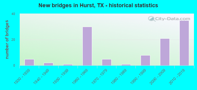
- New bridges - historical statistics
- 51930-1939
- 21940-1949
- 11950-1959
- 301960-1969
- 51970-1979
- 11980-1989
- 81990-1999
- 212000-2009
- 352010-2019
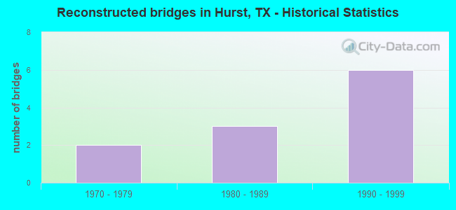
- Reconstructed bridges - Historical Statistics
- 21970-1979
- 31980-1989
- 61990-1999
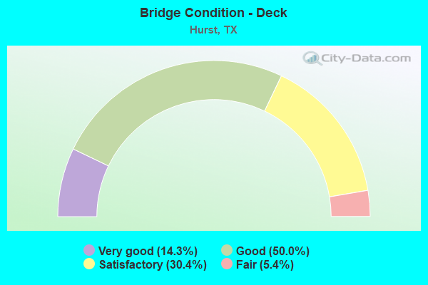
- Bridge Condition - Deck
- 14.3%Very good
- 50.0%Good
- 30.4%Satisfactory
- 5.4%Fair
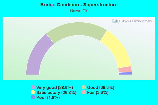
- Bridge Condition - Superstructure
- 28.6%Very good
- 39.3%Good
- 26.8%Satisfactory
- 3.6%Fair
- 1.8%Poor
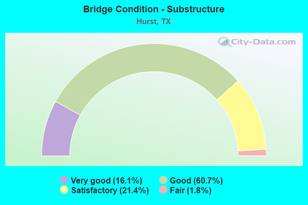
- Bridge Condition - Substructure
- 16.1%Very good
- 60.7%Good
- 21.4%Satisfactory
- 1.8%Fair
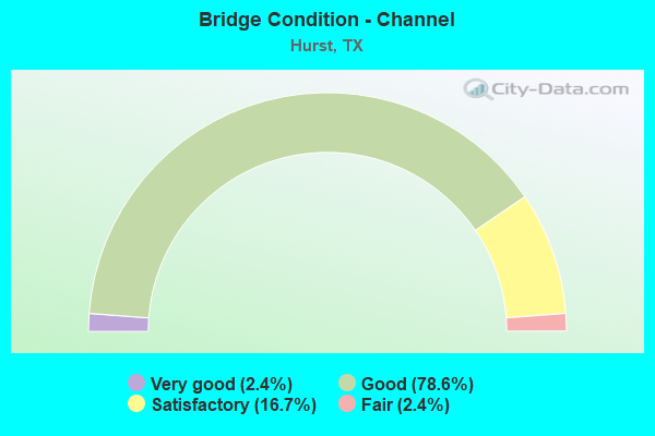
- Bridge Condition - Channel
- 2.4%Very good
- 78.6%Good
- 16.7%Satisfactory
- 2.4%Fair
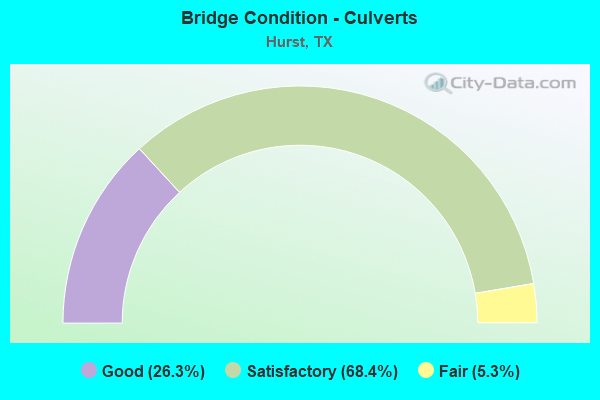
- Bridge Condition - Culverts
- 26.3%Good
- 68.4%Satisfactory
- 5.3%Fair
Find on map >> Show street view
Structure Number: 22200000813131, Location: 3.0 MI N OF IH 30 (Lat: 32.804736, Lng: -97.212286), Route carried "on" structure: Ramp Interstate 820, Year Built: 1963, Status: Open, Structure Length: 7.56m (24.80ft), Average Daily Traffic: 9,922 (year 2018), Truck Traffic: 5%, Average Future Daily Traffic: 14,050 (year 2033), Design Load: HS 20, Features Intersected: TRE & FTG RD
Minimum Vertical Clearance: 30+ m (98+ ft), Kilometerpoint: 42.698, Lanes on structure: 1, Lanes under structure: 2, Owner: State Highway Agency, Approaching Roadway Width: 6.7m (22.0ft), Skew: 2 degrees, Material/Design: Prestressed concrete, Design/Construction: Stringer/Multi-beam, Number Of Spans In Main Unit: 5, Length of Maximum Span: 15.2m (49.9ft), Curb-To-Curb Width: 7.2m (23.6ft), Out-to-Out Width: 7.7m (25.3ft)
Condition: Deck: Satisfactory, Superstructure: Good, Substructure: Satisfactory, Operating Rating: 54.4 metric tons, Method Used To Determine Operating Rating: Assigned rating based on Load Factor Design (LFD) reported in metric tons, Inventory Rating: 32.7 metric tons, Method Used To Determine Inventory Rating: Assigned rating based on Load Factor Design (LFD) reported in metric tons, Structural Evaluation: Equal to present minimum criteria, Deck Geometry: Equal to present minimum criteria, Underclear: Better than present minimum criteria, Approach Roadway Alignment: Equal to present desirable criteria, Designated Inspection Frequency: Every 24 months, Inspection Date: May 2020, Deck Structure Type: Concrete Cast-file-Place, Wearing Surface/Protective System: Wearing Surface: Bituminous
Find on map >> Show street view
Structure Number: 22200000813134, Location: 3.1 MI N OF IH 30 (Lat: 32.805778, Lng: -97.212250), Route carried "on" structure: Ramp Interstate 820, Year Built: 1963, Status: Open, Structure Length: 6.74m (22.11ft), Average Daily Traffic: 10,040 (year 2013), Truck Traffic: 5%, Average Future Daily Traffic: 14,050 (year 2033), Design Load: HS 20, Features Intersected: SH 121
Minimum Vertical Clearance: 30+ m (98+ ft), Kilometerpoint: 42.588, Lanes on structure: 1, Lanes under structure: 4, Owner: State Highway Agency, Approaching Roadway Width: 7.6m (24.9ft), Skew: 4 degrees, Material/Design: Prestressed concrete, Design/Construction: Stringer/Multi-beam, Number Of Spans In Main Unit: 2, Number Of Approach Spans: 2, Length of Maximum Span: 20.4m (66.9ft), Curb-To-Curb Width: 7.3m (24.0ft), Out-to-Out Width: 8.0m (26.2ft)
Condition: Deck: Satisfactory, Superstructure: Good, Substructure: Satisfactory, Operating Rating: 54.4 metric tons, Method Used To Determine Operating Rating: Assigned rating based on Load Factor Design (LFD) reported in metric tons, Inventory Rating: 32.7 metric tons, Method Used To Determine Inventory Rating: Assigned rating based on Load Factor Design (LFD) reported in metric tons, Structural Evaluation: Equal to present minimum criteria, Deck Geometry: Better than present minimum criteria, Underclear: High priority of corrective action, Approach Roadway Alignment: Equal to present desirable criteria, Designated Inspection Frequency: Every 24 months, Inspection Date: May 2020, Deck Structure Type: Concrete Cast-file-Place, Wearing Surface/Protective System: Wearing Surface: Bituminous
Find on map >> Show street view
Structure Number: 22200000813135, Location: 3.1 MI N OF IH 30 (Lat: 32.805886, Lng: -97.212092), Route carried "on" structure: Interstate 820, Year Built: 1963, Status: Open, Structure Length: 6.83m (22.41ft), Average Daily Traffic: 51,476 (year 2019), Truck Traffic: 5%, Average Future Daily Traffic: 70,280 (year 2033), Design Load: HS 20, Features Intersected: SH 121
Minimum Vertical Clearance: 30+ m (98+ ft), Kilometerpoint: 42.588, Lanes on structure: 2, Lanes under structure: 4, Base Highway Network: Yes, Owner: State Highway Agency, Approaching Roadway Width: 9.8m (32.2ft), Skew: 4 degrees, Material/Design: Prestressed concrete, Design/Construction: Stringer/Multi-beam, Number Of Spans In Main Unit: 2, Number Of Approach Spans: 2, Length of Maximum Span: 21.6m (70.9ft), Curb or Sidewalk Widths: Left: 0.0m, Right: 1.8m (5.9ft), Curb-To-Curb Width: 9.8m (32.2ft), Out-to-Out Width: 10.6m (34.8ft)
Condition: Deck: Satisfactory, Superstructure: Satisfactory, Substructure: Satisfactory, Operating Rating: 54.4 metric tons, Method Used To Determine Operating Rating: Assigned rating based on Load Factor Design (LFD) reported in metric tons, Inventory Rating: 32.7 metric tons, Method Used To Determine Inventory Rating: Assigned rating based on Load Factor Design (LFD) reported in metric tons, Structural Evaluation: Equal to present minimum criteria, Deck Geometry: Meets minimum limits, Underclear: High priority of corrective action, Approach Roadway Alignment: Equal to present desirable criteria, Designated Inspection Frequency: Every 24 months, Inspection Date: May 2020, Deck Structure Type: Concrete Cast-file-Place, Wearing Surface/Protective System: Wearing Surface: Bituminous
Find on map >> Show street view
Structure Number: 22200000813136, Location: 1.0 MI S OF PIPELINE (Lat: 32.809086, Lng: -97.209597), Route carried "on" structure: State highway 183, Year Built: 1963, Status: Open, Structure Length: 10.61m (34.81ft), Average Daily Traffic: 15,963 (year 2018), Truck Traffic: 11%, Average Future Daily Traffic: 21,250 (year 2031), Design Load: H 20, Features Intersected: IH-820
Minimum Vertical Clearance: 30+ m (98+ ft), Kilometerpoint: 3.534, Lanes on structure: 2, Lanes under structure: 9, Base Highway Network: Yes, Owner: State Highway Agency, Approaching Roadway Width: 7.9m (25.9ft), Skew: 3 degrees, Material/Design: Steel continuous, Design/Construction: Stringer/Multi-beam, Number Of Spans In Main Unit: 4, Number Of Approach Spans: 1, Length of Maximum Span: 23.8m (78.1ft), Curb or Sidewalk Widths: Left: 1.5m (4.9ft), Right: 0.0m, Curb-To-Curb Width: 7.9m (25.9ft), Out-to-Out Width: 10.1m (33.1ft)
Condition: Deck: Fair, Superstructure: Poor, Substructure: Satisfactory, Operating Rating: 45.4 metric tons, Method Used To Determine Operating Rating: Load Factor (LF), Inventory Rating: 26.3 metric tons, Method Used To Determine Inventory Rating: Load Factor (LF), Structural Evaluation: Meets minimum limits, Deck Geometry: High priority of replacement, Underclear: High priority of corrective action, Approach Roadway Alignment: Equal to present desirable criteria, Length Of Structure Improvement: 10.64m (34.91ft), Designated Inspection Frequency: Every 24 months, Inspection Date: May 2020, Bridge Improvement Cost: $494,000, Roadway Improvement Cost: $622,000, Total Project Cost: $1,500,000, Deck Structure Type: Concrete Cast-file-Place, Wearing Surface/Protective System: Wearing Surface: Bituminous
Find on map >> Show street view
Structure Number: 22200000813152, Location: 0.5 MI N OF SH 10 (Lat: 32.816600, Lng: -97.206319), Route carried "on" structure: Interstate 820, Year Built: 1965, Year Reconstructed: 1985, Status: Open, Structure Length: 3.66m (12.01ft), Average Daily Traffic: 81,170 (year 2013), Truck Traffic: 4%, Average Future Daily Traffic: 113,640 (year 2033), Design Load: HS 20, Features Intersected: CALLOWAY BRANCH
Minimum Vertical Clearance: 30+ m (98+ ft), Kilometerpoint: 41.247, Lanes on structure: 5, Base Highway Network: Yes, Owner: State Highway Agency, Approaching Roadway Width: 30.5m (100.1ft), Material/Design: Prestressed concrete, Design/Construction: Stringer/Multi-beam, Number Of Spans In Main Unit: 3, Length of Maximum Span: 12.2m (40.0ft), Curb-To-Curb Width: 30.5m (100.1ft), Out-to-Out Width: 31.0m (101.7ft)
Condition: Deck: Good, Superstructure: Good, Substructure: Satisfactory, Channel: Good, Operating Rating: 54.4 metric tons, Method Used To Determine Operating Rating: Assigned rating based on Load Factor Design (LFD) reported in metric tons, Inventory Rating: 32.7 metric tons, Method Used To Determine Inventory Rating: Assigned rating based on Load Factor Design (LFD) reported in metric tons, Structural Evaluation: Equal to present minimum criteria, Deck Geometry: Superior to present desirable criteria, Waterway Adequacy: Equal to present desirable criteria, Approach Roadway Alignment: Equal to present desirable criteria, Designated Inspection Frequency: Every 24 months, Inspection Date: May 2020, Deck Structure Type: Concrete Cast-file-Place, Wearing Surface/Protective System: Wearing Surface: Bituminous
Find on map >> Show street view
Structure Number: 22200000813153, Location: 0.5 MI N OF SH 10 (Lat: 32.816586, Lng: -97.206469), Route carried "on" structure: Interstate 820, Year Built: 1965, Year Reconstructed: 1978, Status: Open, Structure Length: 3.66m (12.01ft), Average Daily Traffic: 81,170 (year 2013), Truck Traffic: 4%, Average Future Daily Traffic: 113,640 (year 2033), Design Load: HS 20, Features Intersected: CALLOWAY BRANCH
Minimum Vertical Clearance: 30+ m (98+ ft), Kilometerpoint: 41.247, Lanes on structure: 4, Base Highway Network: Yes, Owner: State Highway Agency, Approaching Roadway Width: 20.7m (67.9ft), Material/Design: Prestressed concrete, Design/Construction: Stringer/Multi-beam, Number Of Spans In Main Unit: 3, Length of Maximum Span: 12.2m (40.0ft), Curb-To-Curb Width: 21.4m (70.2ft), Out-to-Out Width: 21.9m (71.9ft)
Condition: Deck: Good, Superstructure: Good, Substructure: Satisfactory, Channel: Good, Operating Rating: 54.4 metric tons, Method Used To Determine Operating Rating: Assigned rating based on Load Factor Design (LFD) reported in metric tons, Inventory Rating: 32.7 metric tons, Method Used To Determine Inventory Rating: Assigned rating based on Load Factor Design (LFD) reported in metric tons, Structural Evaluation: Equal to present minimum criteria, Deck Geometry: Better than present minimum criteria, Waterway Adequacy: Equal to present desirable criteria, Approach Roadway Alignment: Equal to present desirable criteria, Designated Inspection Frequency: Every 24 months, Inspection Date: May 2020, Deck Structure Type: Concrete Cast-file-Place, Wearing Surface/Protective System: Wearing Surface: Bituminous
Find on map >> Show street view
Structure Number: 22200000813174, Location: 0.5 MI N OF SH 10 (Lat: 32.816678, Lng: -97.207003), Route carried "on" structure: ServiceInterstate 820, Year Built: 1967, Status: Open, Structure Length: 3.66m (12.01ft), Average Daily Traffic: 4,446 (year 2019), Truck Traffic: 4%, Average Future Daily Traffic: 5,330 (year 2033), Design Load: H 20, Features Intersected: CALLOWAY BRANCH
Minimum Vertical Clearance: 30+ m (98+ ft), Kilometerpoint: 41.247, Lanes on structure: 2, Owner: State Highway Agency, Approaching Roadway Width: 10.1m (33.1ft), Material/Design: Concrete, Design/Construction: Stringer/Multi-beam, Number Of Spans In Main Unit: 3, Length of Maximum Span: 12.2m (40.0ft), Curb or Sidewalk Widths: Left: 0.0m, Right: 0.7m (2.3ft), Curb-To-Curb Width: 10.1m (33.1ft), Out-to-Out Width: 11.1m (36.4ft)
Condition: Deck: Good, Superstructure: Good, Substructure: Satisfactory, Channel: Good, Operating Rating: 49.9 metric tons, Method Used To Determine Operating Rating: Load Factor (LF), Inventory Rating: 29.0 metric tons, Method Used To Determine Inventory Rating: Load Factor (LF), Structural Evaluation: Equal to present minimum criteria, Deck Geometry: Somewhat better than minimum adequacy, Waterway Adequacy: Equal to present desirable criteria, Approach Roadway Alignment: Equal to present desirable criteria, Length Of Structure Improvement: 3.66m (12.01ft), Designated Inspection Frequency: Every 24 months, Inspection Date: May 2020, Bridge Improvement Cost: $116,000, Roadway Improvement Cost: $19,000, Total Project Cost: $135,000, Deck Structure Type: Concrete Cast-file-Place, Wearing Surface/Protective System: Wearing Surface: Bituminous
Find on map >> Show street view
Structure Number: 22200000813175, Location: 0.5 MI N OF SH 10 (Lat: 32.816456, Lng: -97.205861), Route carried "on" structure: ServiceInterstate 820, Year Built: 1967, Status: Open, Structure Length: 3.66m (12.01ft), Average Daily Traffic: 2,396 (year 2019), Truck Traffic: 3%, Average Future Daily Traffic: 5,070 (year 2030), Design Load: H 20, Features Intersected: CALLOWAY BRANCH
Minimum Vertical Clearance: 30+ m (98+ ft), Kilometerpoint: 41.247, Lanes on structure: 2, Owner: State Highway Agency, Approaching Roadway Width: 9.8m (32.2ft), Material/Design: Concrete, Design/Construction: Stringer/Multi-beam, Number Of Spans In Main Unit: 3, Length of Maximum Span: 12.2m (40.0ft), Curb or Sidewalk Widths: Left: 0.0m, Right: 0.7m (2.3ft), Curb-To-Curb Width: 9.8m (32.2ft), Out-to-Out Width: 11.1m (36.4ft)
Condition: Deck: Good, Superstructure: Good, Substructure: Good, Channel: Good, Operating Rating: 46.3 metric tons, Method Used To Determine Operating Rating: Load Factor (LF), Inventory Rating: 27.2 metric tons, Method Used To Determine Inventory Rating: Load Factor (LF), Structural Evaluation: Equal to present minimum criteria, Deck Geometry: Meets minimum limits, Waterway Adequacy: Equal to present desirable criteria, Approach Roadway Alignment: Equal to present desirable criteria, Length Of Structure Improvement: 3.66m (12.01ft), Designated Inspection Frequency: Every 24 months, Inspection Date: May 2020, Bridge Improvement Cost: $8,000, Roadway Improvement Cost: $2,000, Total Project Cost: $10,000, Deck Structure Type: Concrete Cast-file-Place, Wearing Surface/Protective System: Wearing Surface: Bituminous
Find on map >> Show street view
Structure Number: 22200000813313, Location: 1.0 MI S OF PIPELINE RD (Lat: 32.808994, Lng: -97.210764), Route carried "on" structure: State highway 183, Year Built: 1963, Status: Open, Structure Length: 10.64m (34.91ft), Average Daily Traffic: 15,963 (year 2018), Truck Traffic: 11%, Average Future Daily Traffic: 21,250 (year 2031), Design Load: H 20, Features Intersected: IH 820
Minimum Vertical Clearance: 5.44m (17.85ft), Kilometerpoint: 3.534, Lanes on structure: 3, Lanes under structure: 9, Base Highway Network: Yes, Owner: State Highway Agency, Approaching Roadway Width: 11.6m (38.1ft), Skew: 3 degrees, Material/Design: Steel continuous, Design/Construction: Stringer/Multi-beam, Number Of Spans In Main Unit: 4, Number Of Approach Spans: 1, Length of Maximum Span: 23.8m (78.1ft), Curb or Sidewalk Widths: Left: 0.0m, Right: 1.5m (4.9ft), Curb-To-Curb Width: 11.6m (38.1ft), Out-to-Out Width: 13.7m (44.9ft)
Condition: Deck: Fair, Superstructure: Satisfactory, Substructure: Satisfactory, Operating Rating: 41.7 metric tons, Method Used To Determine Operating Rating: Load Factor (LF), Inventory Rating: 25.4 metric tons, Method Used To Determine Inventory Rating: Load Factor (LF), Structural Evaluation: Equal to present minimum criteria, Deck Geometry: High priority of replacement, Underclear: High priority of corrective action, Approach Roadway Alignment: Equal to present desirable criteria, Length Of Structure Improvement: 10.64m (34.91ft), Designated Inspection Frequency: Every 24 months, Inspection Date: May 2020, Bridge Improvement Cost: $494,000, Roadway Improvement Cost: $622,000, Total Project Cost: $1,500,000, Deck Structure Type: Concrete Cast-file-Place, Wearing Surface/Protective System: Wearing Surface: Bituminous
Find on map >> Show street view
Structure Number: 22200000813402, Location: 1.0 MI N OF SH 10 (Lat: 32.823044, Lng: -97.205536), Route carried "on" structure: Interstate 820, Year Built: 1998, Status: Open, Structure Length: 8.93m (29.30ft), Average Daily Traffic: 81,170 (year 2013), Truck Traffic: 4%, Average Future Daily Traffic: 113,640 (year 2033), Design Load: HS 20, Features Intersected: GLENVIEW DRIVE
Minimum Vertical Clearance: 30+ m (98+ ft), Kilometerpoint: 40.464, Lanes on structure: 6, Lanes under structure: 10, Base Highway Network: Yes, Owner: State Highway Agency, Approaching Roadway Width: 33.5m (109.9ft), Material/Design: Steel, Design/Construction: Stringer/Multi-beam, Number Of Spans In Main Unit: 1, Number Of Approach Spans: 2, Length of Maximum Span: 44.5m (146.0ft), Curb-To-Curb Width: 28.5m (93.5ft), Out-to-Out Width: 29.1m (95.5ft)
Condition: Deck: Good, Superstructure: Good, Substructure: Good, Operating Rating: 54.4 metric tons, Method Used To Determine Operating Rating: Assigned rating based on Load Factor Design (LFD) reported in metric tons, Inventory Rating: 32.7 metric tons, Method Used To Determine Inventory Rating: Assigned rating based on Load Factor Design (LFD) reported in metric tons, Structural Evaluation: Better than present minimum criteria, Deck Geometry: Better than present minimum criteria, Underclear: Meets minimum limits, Approach Roadway Alignment: Equal to present desirable criteria, Designated Inspection Frequency: Every 24 months, Inspection Date: May 2020, Deck Structure Type: Concrete Cast-file-Place
Find on map >> Show street view
Structure Number: 22200000813403, Location: 1.0 MI N OF SH 10 (Lat: 32.823894, Lng: -97.205978), Route carried "on" structure: Interstate 820, Year Built: 1998, Status: Open, Structure Length: 8.93m (29.30ft), Average Daily Traffic: 81,170 (year 2013), Truck Traffic: 4%, Average Future Daily Traffic: 113,640 (year 2033), Design Load: HS 20, Features Intersected: GLENVIEW DRIVE
Minimum Vertical Clearance: 30+ m (98+ ft), Kilometerpoint: 40.464, Lanes on structure: 5, Lanes under structure: 10, Base Highway Network: Yes, Owner: State Highway Agency, Approaching Roadway Width: 32.9m (107.9ft), Material/Design: Steel, Design/Construction: Stringer/Multi-beam, Number Of Spans In Main Unit: 1, Number Of Approach Spans: 2, Length of Maximum Span: 44.5m (146.0ft), Curb-To-Curb Width: 33.6m (110.2ft), Out-to-Out Width: 34.2m (112.2ft)
Condition: Deck: Good, Superstructure: Good, Substructure: Good, Operating Rating: 54.4 metric tons, Method Used To Determine Operating Rating: Assigned rating based on Load Factor Design (LFD) reported in metric tons, Inventory Rating: 32.7 metric tons, Method Used To Determine Inventory Rating: Assigned rating based on Load Factor Design (LFD) reported in metric tons, Structural Evaluation: Better than present minimum criteria, Deck Geometry: Superior to present desirable criteria, Underclear: Meets minimum limits, Approach Roadway Alignment: Equal to present desirable criteria, Designated Inspection Frequency: Every 24 months, Inspection Date: May 2020, Deck Structure Type: Concrete Cast-file-Place, Wearing Surface/Protective System: Wearing Surface: Bituminous
Find on map >> Show street view
Structure Number: 22200000813413, Location: IH 820 AT SH 121 (Lat: 32.831558, Lng: -97.205722), Route carried "on" structure: Ramp Interstate 820, Year Built: 2001, Status: Open, Structure Length: 11.37m (37.30ft), Average Daily Traffic: 5,410 (year 2016), Average Future Daily Traffic: 5,510 (year 2036), Design Load: HS 20, Features Intersected: SH 121 SB
Minimum Vertical Clearance: 30+ m (98+ ft), Kilometerpoint: 38.277, Lanes on structure: 3, Lanes under structure: 4, Owner: State Highway Agency, Maintenance Responsibility: Local Toll Authority, Approaching Roadway Width: 20.7m (67.9ft), Skew: 9 degrees, Material/Design: Prestressed concrete, Design/Construction: Stringer/Multi-beam, Number Of Spans In Main Unit: 3, Length of Maximum Span: 40.2m (131.9ft), Curb-To-Curb Width: 20.8m (68.2ft), Out-to-Out Width: 21.4m (70.2ft)
Condition: Deck: Very good, Superstructure: Good, Substructure: Good, Operating Rating: 54.4 metric tons, Method Used To Determine Operating Rating: Assigned rating based on Load Factor Design (LFD) reported in metric tons, Inventory Rating: 32.7 metric tons, Method Used To Determine Inventory Rating: Assigned rating based on Load Factor Design (LFD) reported in metric tons, Structural Evaluation: Better than present minimum criteria, Deck Geometry: Superior to present desirable criteria, Underclear: Equal to present minimum criteria, Approach Roadway Alignment: Equal to present desirable criteria, Designated Inspection Frequency: Every 24 months, Inspection Date: May 2020, Deck Structure Type: Concrete Cast-file-Place
Find on map >> Show street view
Structure Number: 22200000813416, Location: 820 N OR SH 121 (Lat: 32.831983, Lng: -97.207525), Route carried "on" structure: Interstate 820, Year Built: 2001, Status: Open, Structure Length: 26.12m (85.70ft), Average Daily Traffic: 123,450 (year 2013), Truck Traffic: 5%, Average Future Daily Traffic: 172,830 (year 2033), Design Load: HS 20, Features Intersected: RAMP A EB CONN RAMP I
Minimum Vertical Clearance: 6.86m (22.51ft), Kilometerpoint: 37.583, Lanes on structure: 5, Lanes under structure: 7, Base Highway Network: Yes, Owner: State Highway Agency, Approaching Roadway Width: 30.5m (100.1ft), Skew: 39 degrees, Material/Design: Steel, Design/Construction: Stringer/Multi-beam, Number Of Spans In Main Unit: 1, Number Of Approach Spans: 7, Length of Maximum Span: 47.2m (154.9ft), Curb-To-Curb Width: 30.3m (99.4ft), Out-to-Out Width: 31.8m (104.3ft)
Condition: Deck: Good, Superstructure: Very good, Substructure: Good, Operating Rating: 54.4 metric tons, Method Used To Determine Operating Rating: Assigned rating based on Load Factor Design (LFD) reported in metric tons, Inventory Rating: 32.7 metric tons, Method Used To Determine Inventory Rating: Assigned rating based on Load Factor Design (LFD) reported in metric tons, Structural Evaluation: Better than present minimum criteria, Deck Geometry: Superior to present desirable criteria, Underclear: High priority of corrective action, Approach Roadway Alignment: Equal to present desirable criteria, Designated Inspection Frequency: Every 24 months, Inspection Date: May 2020, Deck Structure Type: Concrete Cast-file-Place
Find on map >> Show street view
Structure Number: 22200000813419, Location: .5 MI E OF SH 26 (Lat: 32.831900, Lng: -97.207739), Route carried "on" structure: Ramp Interstate 820, Year Built: 2002, Status: Open, Structure Length: 12.98m (42.59ft), Average Daily Traffic: 12,630 (year 2013), Truck Traffic: 5%, Average Future Daily Traffic: 17,690 (year 2033), Design Load: HS 20, Features Intersected: SH 121 EB
Minimum Vertical Clearance: 30+ m (98+ ft), Kilometerpoint: 38.951, Lanes on structure: 1, Lanes under structure: 3, Owner: State Highway Agency, Approaching Roadway Width: 7.9m (25.9ft), Skew: 9 degrees, Material/Design: Prestressed concrete, Design/Construction: Stringer/Multi-beam, Number Of Spans In Main Unit: 1, Number Of Approach Spans: 4, Length of Maximum Span: 36.6m (120.1ft), Curb-To-Curb Width: 7.8m (25.6ft), Out-to-Out Width: 8.5m (27.9ft)
Condition: Deck: Good, Superstructure: Very good, Substructure: Good, Operating Rating: 54.4 metric tons, Method Used To Determine Operating Rating: Assigned rating based on Load Factor Design (LFD) reported in metric tons, Inventory Rating: 32.7 metric tons, Method Used To Determine Inventory Rating: Assigned rating based on Load Factor Design (LFD) reported in metric tons, Structural Evaluation: Better than present minimum criteria, Deck Geometry: Better than present minimum criteria, Underclear: High priority of corrective action, Approach Roadway Alignment: Equal to present desirable criteria, Designated Inspection Frequency: Every 24 months, Inspection Date: May 2020, Deck Structure Type: Concrete Precast Panels
Find on map >> Show street view
Structure Number: 2220000081342, Location: 0.1 MI N OF PIPELINE RD (Lat: 32.826400, Lng: -97.204781), Route carried "on" structure: Ramp Interstate 820, Year Built: 2002, Status: Open, Structure Length: 44.07m (144.59ft), Average Daily Traffic: 29,690 (year 2016), Average Future Daily Traffic: 148,880 (year 2036), Design Load: HS 20, Features Intersected: SH 121
Minimum Vertical Clearance: 30+ m (98+ ft), Kilometerpoint: 38.190, Lanes on structure: 1, Lanes under structure: 7, Owner: State Highway Agency, Approaching Roadway Width: 7.9m (25.9ft), Skew: 9 degrees, Material/Design: Steel continuous, Design/Construction: Stringer/Multi-beam, Number Of Spans In Main Unit: 4, Number Of Approach Spans: 5, Length of Maximum Span: 76.2m (250.0ft), Curb-To-Curb Width: 7.7m (25.3ft), Out-to-Out Width: 8.5m (27.9ft)
Condition: Deck: Good, Superstructure: Good, Substructure: Good, Operating Rating: 54.4 metric tons, Method Used To Determine Operating Rating: Assigned rating based on Load Factor Design (LFD) reported in metric tons, Inventory Rating: 32.7 metric tons, Method Used To Determine Inventory Rating: Assigned rating based on Load Factor Design (LFD) reported in metric tons, Structural Evaluation: Better than present minimum criteria, Deck Geometry: Better than present minimum criteria, Underclear: High priority of corrective action, Approach Roadway Alignment: Equal to present desirable criteria, Designated Inspection Frequency: Every 24 months, Inspection Date: May 2020, Deck Structure Type: Concrete Cast-file-Place
Find on map >> Show street view
Structure Number: 22200000813441, Location: .4 MI N OF GLENVIEW DR (Lat: 32.831397, Lng: -97.208669), Route carried "on" structure: Ramp Interstate 820, Year Built: 2002, Status: Open, Structure Length: 50.23m (164.80ft), Average Daily Traffic: 16,230 (year 2013), Truck Traffic: 4%, Average Future Daily Traffic: 22,720 (year 2033), Design Load: HS 20, Features Intersected: SH 121 SB
Minimum Vertical Clearance: 30+ m (98+ ft), Kilometerpoint: 39.688, Lanes on structure: 1, Lanes under structure: 5, Owner: State Highway Agency, Approaching Roadway Width: 7.9m (25.9ft), Skew: 9 degrees, Material/Design: Prestressed concrete, Design/Construction: Stringer/Multi-beam, Number Of Spans In Main Unit: 14, Number Of Approach Spans: 1, Length of Maximum Span: 38.1m (125.0ft), Curb-To-Curb Width: 7.7m (25.3ft), Out-to-Out Width: 8.5m (27.9ft)
Condition: Deck: Good, Superstructure: Good, Substructure: Good, Operating Rating: 54.4 metric tons, Method Used To Determine Operating Rating: Assigned rating based on Load Factor Design (LFD) reported in metric tons, Inventory Rating: 32.7 metric tons, Method Used To Determine Inventory Rating: Assigned rating based on Load Factor Design (LFD) reported in metric tons, Structural Evaluation: Better than present minimum criteria, Deck Geometry: Better than present minimum criteria, Underclear: High priority of corrective action, Approach Roadway Alignment: Equal to present desirable criteria, Designated Inspection Frequency: Every 24 months, Inspection Date: May 2020, Deck Structure Type: Concrete Cast-file-Place
Find on map >> Show street view
Structure Number: 22200000814514, Location: SH 183W to 820S @ IH820 (Lat: 32.828081, Lng: -97.205736), Route carried "on" structure: Ramp State highway 183, Year Built: 2014, Status: Open, Structure Length: 93.15m (305.61ft), Average Daily Traffic: 8,400 (year 2013), Truck Traffic: 3%, Average Future Daily Traffic: 10,800 (year 2033), Design Load: HL 93, Features Intersected: IH-820
Minimum Vertical Clearance: 30+ m (98+ ft), Kilometerpoint: 0.000, Lanes on structure: 1, Lanes under structure: 18, Toll: On toll road, Owner: State Highway Agency, Maintenance Responsibility: Local Toll Authority, Approaching Roadway Width: 7.9m (25.9ft), Skew: 9 degrees, Material/Design: Steel, Design/Construction: Stringer/Multi-beam, Number Of Spans In Main Unit: 2, Number Of Approach Spans: 26, Length of Maximum Span: 56.7m (186.0ft), Curb-To-Curb Width: 7.8m (25.6ft), Out-to-Out Width: 8.5m (27.9ft)
Condition: Deck: Good, Superstructure: Good, Substructure: Good, Operating Rating: 54.4 metric tons, Method Used To Determine Operating Rating: Assigned ratings based on Load and Resistance Factor Design (LRFD) reported in metric tons, Inventory Rating: 32.7 metric tons, Method Used To Determine Inventory Rating: Assigned ratings based on Load and Resistance Factor Design (LRFD) reported in metric tons, Structural Evaluation: Better than present minimum criteria, Deck Geometry: Better than present minimum criteria, Underclear: High priority of corrective action, Approach Roadway Alignment: Equal to present desirable criteria, Designated Inspection Frequency: Every 24 months, Inspection Date: May 2020, Deck Structure Type: Concrete Cast-file-Place
Find on map >> Show street view
Structure Number: 22200000814515, Location: IH820N to 183E @ IH820 (Lat: 32.827617, Lng: -97.205308), Route carried "on" structure: Ramp Interstate 820, Year Built: 2014, Status: Open, Structure Length: 75.26m (246.92ft), Average Daily Traffic: 10,600 (year 2013), Truck Traffic: 7%, Average Future Daily Traffic: 13,800 (year 2033), Design Load: HL 93, Features Intersected: IH-820
Minimum Vertical Clearance: 30+ m (98+ ft), Kilometerpoint: 0.000, Lanes on structure: 1, Lanes under structure: 4, Toll: On toll road, Owner: State Highway Agency, Maintenance Responsibility: Local Toll Authority, Approaching Roadway Width: 7.9m (25.9ft), Skew: 9 degrees, Material/Design: Prestressed concrete, Design/Construction: Stringer/Multi-beam, Number Of Spans In Main Unit: 23, Length of Maximum Span: 38.1m (125.0ft), Curb-To-Curb Width: 7.9m (25.9ft), Out-to-Out Width: 8.5m (27.9ft)
Condition: Deck: Good, Superstructure: Good, Substructure: Good, Operating Rating: 54.4 metric tons, Method Used To Determine Operating Rating: Assigned ratings based on Load and Resistance Factor Design (LRFD) reported in metric tons, Inventory Rating: 32.7 metric tons, Method Used To Determine Inventory Rating: Assigned ratings based on Load and Resistance Factor Design (LRFD) reported in metric tons, Structural Evaluation: Better than present minimum criteria, Deck Geometry: Equal to present desirable criteria, Underclear: Meets minimum limits, Approach Roadway Alignment: Equal to present desirable criteria, Designated Inspection Frequency: Every 24 months, Inspection Date: May 2020, Deck Structure Type: Concrete Precast Panels
Find on map >> Show street view
Structure Number: 22200000814516, Location: IH820 ML Viaduct @ SH183 (Lat: 32.832922, Lng: -97.210656), Route carried "on" structure: Other road 820, Year Built: 2014, Status: Open, Structure Length: 136.86m (449.02ft), Average Daily Traffic: 43,299 (year 2018), Truck Traffic: 7%, Average Future Daily Traffic: 67,200 (year 2033), Design Load: HL 93, Features Intersected: SH 183
Minimum Vertical Clearance: 5.08m (16.67ft), Kilometerpoint: 0.000, Lanes on structure: 4, Lanes under structure: 11, Toll: On toll road, Owner: State Highway Agency, Maintenance Responsibility: Local Toll Authority, Approaching Roadway Width: 23.8m (78.1ft), Skew: 39 degrees, Material/Design: Steel, Design/Construction: Stringer/Multi-beam, Number Of Spans In Main Unit: 1, Number Of Approach Spans: 42, Length of Maximum Span: 55.5m (182.1ft), Curb-To-Curb Width: 23.8m (78.1ft), Out-to-Out Width: 24.4m (80.1ft)
Condition: Deck: Good, Superstructure: Good, Substructure: Good, Operating Rating: 54.4 metric tons, Method Used To Determine Operating Rating: Assigned ratings based on Load and Resistance Factor Design (LRFD) reported in metric tons, Inventory Rating: 32.7 metric tons, Method Used To Determine Inventory Rating: Assigned ratings based on Load and Resistance Factor Design (LRFD) reported in metric tons, Structural Evaluation: Better than present minimum criteria, Deck Geometry: Equal to present minimum criteria, Underclear: High priority of corrective action, Approach Roadway Alignment: Equal to present desirable criteria, Designated Inspection Frequency: Every 24 months, Inspection Date: May 2020, Deck Structure Type: Concrete Cast-file-Place
Find on map >> Show street view
Structure Number: 22200000814525, Location: IH820 ML VIADUCT @ SH183 (Lat: 32.833775, Lng: -97.199614), Route carried "on" structure: Other road 820, Year Built: 2014, Status: Open, Structure Length: 31.82m (104.40ft), Average Daily Traffic: 22,700 (year 2013), Truck Traffic: 7%, Average Future Daily Traffic: 33,600 (year 2033), Design Load: HL 93, Features Intersected: SH 183
Minimum Vertical Clearance: 5.08m (16.67ft), Kilometerpoint: 0.000, Lanes on structure: 2, Lanes under structure: 4, Toll: On toll road, Owner: State Highway Agency, Maintenance Responsibility: Local Toll Authority, Approaching Roadway Width: 12.2m (40.0ft), Material/Design: Prestressed concrete, Design/Construction: Stringer/Multi-beam, Number Of Spans In Main Unit: 11, Length of Maximum Span: 30.5m (100.1ft), Curb-To-Curb Width: 13.7m (44.9ft), Out-to-Out Width: 14.6m (47.9ft)
Condition: Deck: Good, Superstructure: Good, Substructure: Good, Operating Rating: 54.4 metric tons, Method Used To Determine Operating Rating: Assigned ratings based on Load and Resistance Factor Design (LRFD) reported in metric tons, Inventory Rating: 32.7 metric tons, Method Used To Determine Inventory Rating: Assigned ratings based on Load and Resistance Factor Design (LRFD) reported in metric tons, Structural Evaluation: Better than present minimum criteria, Deck Geometry: Equal to present minimum criteria, Underclear: Meets minimum limits, Approach Roadway Alignment: Equal to present desirable criteria, Designated Inspection Frequency: Every 24 months, Inspection Date: May 2020, Deck Structure Type: Concrete Cast-file-Place
Find on map >> Show street view
Structure Number: 22200009402007, Location: 2.5 MI E OF IH 820 (Lat: 32.808739, Lng: -97.166203), Route carried "on" structure: State highway 10, Year Built: 1939, Year Reconstructed: 1998, Status: Open, Structure Length: 0.82m (2.69ft), Average Daily Traffic: 18,125 (year 2019), Truck Traffic: 5%, Average Future Daily Traffic: 34,310 (year 2033), Design Load: H 15, Features Intersected: TRB TO WALKER BRANCH
Minimum Vertical Clearance: 30+ m (98+ ft), Kilometerpoint: 7.694, Lanes on structure: 6, Base Highway Network: Yes, Owner: State Highway Agency, Approaching Roadway Width: 21.9m (71.9ft), Skew: 20 degrees, Material/Design: Concrete, Design/Construction: Culvert, Number Of Spans In Main Unit: 3, Length of Maximum Span: 2.4m (7.9ft)
Condition: Channel: Good, Culverts: Satisfactory, Operating Rating: 39.9 metric tons, Method Used To Determine Operating Rating: Load Factor (LF), Inventory Rating: 23.6 metric tons, Method Used To Determine Inventory Rating: Load Factor (LF), Structural Evaluation: Somewhat better than minimum adequacy, Waterway Adequacy: Equal to present minimum criteria, Approach Roadway Alignment: Equal to present desirable criteria, Designated Inspection Frequency: Every 24 months, Inspection Date: April 2020
Find on map >> Show street view
Structure Number: 2220000940201, Location: 0.8 MI E OF IH 820 (Lat: 32.809031, Lng: -97.194578), Route carried "on" structure: State highway 10, Year Built: 1939, Year Reconstructed: 1998, Status: Open, Structure Length: 3.41m (11.19ft), Average Daily Traffic: 16,749 (year 2020), Truck Traffic: 2%, Average Future Daily Traffic: 40,730 (year 2033), Design Load: H 15, Features Intersected: CALLOWAY BRANCH
Minimum Vertical Clearance: 30+ m (98+ ft), Kilometerpoint: 5.011, Lanes on structure: 6, Base Highway Network: Yes, Owner: State Highway Agency, Approaching Roadway Width: 24.4m (80.1ft), Skew: 29 degrees, Material/Design: Concrete, Design/Construction: Culvert, Number Of Spans In Main Unit: 10, Length of Maximum Span: 3.0m (9.8ft)
Condition: Channel: Satisfactory, Culverts: Satisfactory, Operating Rating: 39.9 metric tons, Method Used To Determine Operating Rating: Load Factor (LF), Inventory Rating: 23.6 metric tons, Method Used To Determine Inventory Rating: Load Factor (LF), Structural Evaluation: Somewhat better than minimum adequacy, Waterway Adequacy: Equal to present minimum criteria, Approach Roadway Alignment: Equal to present desirable criteria, Designated Inspection Frequency: Every 24 months, Inspection Date: April 2020
Find on map >> Show street view
Structure Number: 22200009402011, Location: 1.0 MI E OF IH 820 (Lat: 32.809022, Lng: -97.191567), Route carried "on" structure: State highway 10, Year Built: 1939, Year Reconstructed: 1998, Status: Open, Structure Length: 0.82m (2.69ft), Average Daily Traffic: 16,749 (year 2020), Truck Traffic: 2%, Average Future Daily Traffic: 40,730 (year 2033), Design Load: H 15, Features Intersected: CALLOWAY BRANCH RELIEF
Minimum Vertical Clearance: 30+ m (98+ ft), Kilometerpoint: 5.205, Lanes on structure: 7, Base Highway Network: Yes, Owner: State Highway Agency, Approaching Roadway Width: 21.9m (71.9ft), Skew: 20 degrees, Material/Design: Concrete, Design/Construction: Culvert, Number Of Spans In Main Unit: 4, Length of Maximum Span: 1.8m (5.9ft)
Condition: Channel: Satisfactory, Culverts: Satisfactory, Operating Rating: 39.9 metric tons, Method Used To Determine Operating Rating: Load Factor (LF), Inventory Rating: 23.6 metric tons, Method Used To Determine Inventory Rating: Load Factor (LF), Structural Evaluation: Somewhat better than minimum adequacy, Waterway Adequacy: Equal to present minimum criteria, Approach Roadway Alignment: Equal to present desirable criteria, Length Of Structure Improvement: 0.82m (2.69ft), Designated Inspection Frequency: Every 24 months, Inspection Date: April 2020, Bridge Improvement Cost: $4,000, Roadway Improvement Cost: $1,000, Total Project Cost: $5,000
Find on map >> Show street view
Structure Number: 22200009402012, Location: 1.7 MI E OF IH 820 (Lat: 32.809239, Lng: -97.179253), Route carried "on" structure: State highway 10, Year Built: 1939, Year Reconstructed: 1998, Status: Open, Structure Length: 2.68m (8.79ft), Average Daily Traffic: 16,749 (year 2020), Truck Traffic: 2%, Average Future Daily Traffic: 40,730 (year 2033), Design Load: H 15, Features Intersected: LOREAN BRANCH
Minimum Vertical Clearance: 30+ m (98+ ft), Kilometerpoint: 6.470, Lanes on structure: 6, Base Highway Network: Yes, Owner: State Highway Agency, Approaching Roadway Width: 25.2m (82.7ft), Skew: 20 degrees, Material/Design: Concrete, Design/Construction: Culvert, Number Of Spans In Main Unit: 10, Length of Maximum Span: 2.4m (7.9ft)
Condition: Channel: Satisfactory, Culverts: Satisfactory, Operating Rating: 39.9 metric tons, Method Used To Determine Operating Rating: Load Factor (LF), Inventory Rating: 23.6 metric tons, Method Used To Determine Inventory Rating: Load Factor (LF), Structural Evaluation: Somewhat better than minimum adequacy, Waterway Adequacy: Equal to present minimum criteria, Approach Roadway Alignment: Equal to present desirable criteria, Designated Inspection Frequency: Every 24 months, Inspection Date: April 2020
Find on map >> Show street view
Structure Number: 222000094021, Location: 1.2 MI E OF IH 820 (Lat: 32.809072, Lng: -97.188356), Route carried "on" structure: State highway 10, Year Built: 1939, Year Reconstructed: 1998, Status: Open, Structure Length: 2.90m (9.51ft), Average Daily Traffic: 16,749 (year 2020), Truck Traffic: 2%, Average Future Daily Traffic: 40,730 (year 2033), Features Intersected: WALKER BRANCH
Minimum Vertical Clearance: 30+ m (98+ ft), Kilometerpoint: 5.591, Lanes on structure: 6, Base Highway Network: Yes, Owner: State Highway Agency, Approaching Roadway Width: 24.4m (80.1ft), Skew: 29 degrees, Material/Design: Concrete, Design/Construction: Culvert, Number Of Spans In Main Unit: 8, Length of Maximum Span: 2.7m (8.9ft)
Condition: Channel: Fair, Culverts: Satisfactory, Operating Rating: 32.7 metric tons, Method Used To Determine Operating Rating: Field evaluation and documented engineering judgment, Inventory Rating: 24.5 metric tons, Method Used To Determine Inventory Rating: Field evaluation and documented engineering judgment, Structural Evaluation: Equal to present minimum criteria, Waterway Adequacy: Equal to present minimum criteria, Approach Roadway Alignment: Equal to present desirable criteria, Designated Inspection Frequency: Every 24 months, Inspection Date: April 2020
Find on map >> Show street view
Structure Number: 22200009402112, Location: 3.0 MI SW OF FM-157 (Lat: 32.811322, Lng: -97.148847), Route carried "on" structure: State highway 10, Year Built: 1993, Status: Open, Structure Length: 2.62m (8.60ft), Average Daily Traffic: 14,047 (year 2020), Truck Traffic: 5%, Average Future Daily Traffic: 34,310 (year 2033), Design Load: HS 20, Features Intersected: SULPHUR BRANCH
Minimum Vertical Clearance: 30+ m (98+ ft), Kilometerpoint: 9.362, Lanes on structure: 6, Base Highway Network: Yes, Owner: State Highway Agency, Approaching Roadway Width: 24.4m (80.1ft), Skew: 20 degrees, Material/Design: Concrete, Design/Construction: Culvert, Number Of Spans In Main Unit: 7, Length of Maximum Span: 3.0m (9.8ft)
Condition: Channel: Satisfactory, Culverts: Good, Operating Rating: 39.9 metric tons, Method Used To Determine Operating Rating: Load Factor (LF), Inventory Rating: 23.6 metric tons, Method Used To Determine Inventory Rating: Load Factor (LF), Structural Evaluation: Somewhat better than minimum adequacy, Waterway Adequacy: Equal to present minimum criteria, Approach Roadway Alignment: Equal to present desirable criteria, Designated Inspection Frequency: Every 48 months, Inspection Date: April 2018
Find on map >> Show street view
Structure Number: 22200036401025, Location: 0.1 MI SW BEDFORD-EULESS (Lat: 32.834128, Lng: -97.202233), Route carried "on" structure: State highway 121, Year Built: 1967, Status: Open, Structure Length: 1.59m (5.22ft), Average Daily Traffic: 110,269 (year 2020), Truck Traffic: 6%, Average Future Daily Traffic: 214,080 (year 2033), Design Load: HS 20, Features Intersected: WALKER BRANCH
Minimum Vertical Clearance: 30+ m (98+ ft), Kilometerpoint: 32.979, Lanes on structure: 16, Base Highway Network: Yes, Owner: State Highway Agency, Maintenance Responsibility: Local Toll Authority, Approaching Roadway Width: 25.6m (84.0ft), Skew: 29 degrees, Material/Design: Concrete, Design/Construction: Culvert, Number Of Spans In Main Unit: 6, Length of Maximum Span: 2.4m (7.9ft)
Condition: Channel: Good, Culverts: Fair, Operating Rating: 39.9 metric tons, Method Used To Determine Operating Rating: Load Factor (LF), Inventory Rating: 23.6 metric tons, Method Used To Determine Inventory Rating: Load Factor (LF), Structural Evaluation: Somewhat better than minimum adequacy, Waterway Adequacy: Equal to present minimum criteria, Approach Roadway Alignment: Equal to present desirable criteria, Designated Inspection Frequency: Every 24 months, Inspection Date: May 2020
Find on map >> Show street view
Structure Number: 2220003640141, Location: 700' W OF BEDFORD EULESS (Lat: 32.833075, Lng: -97.202592), Route carried "on" structure: State highway 121, Year Built: 2001, Status: Open, Structure Length: 3.69m (12.11ft), Average Daily Traffic: 110,269 (year 2020), Truck Traffic: 4%, Average Future Daily Traffic: 87,000 (year 2038), Design Load: HS 20, Features Intersected: RAMP M
Minimum Vertical Clearance: 14.02m (46.00ft), Kilometerpoint: 38.327, Lanes on structure: 2, Lanes under structure: 1, Base Highway Network: Yes, Owner: State Highway Agency, Approaching Roadway Width: 17.1m (56.1ft), Skew: 2 degrees, Material/Design: Prestressed concrete, Design/Construction: Stringer/Multi-beam, Number Of Spans In Main Unit: 1, Length of Maximum Span: 36.9m (121.1ft), Curb-To-Curb Width: 17.1m (56.1ft), Out-to-Out Width: 17.7m (58.1ft)
Condition: Deck: Very good, Superstructure: Good, Substructure: Good, Operating Rating: 54.4 metric tons, Method Used To Determine Operating Rating: Assigned rating based on Load Factor Design (LFD) reported in metric tons, Inventory Rating: 32.7 metric tons, Method Used To Determine Inventory Rating: Assigned rating based on Load Factor Design (LFD) reported in metric tons, Structural Evaluation: Better than present minimum criteria, Deck Geometry: Superior to present desirable criteria, Underclear: Better than present minimum criteria, Approach Roadway Alignment: Equal to present desirable criteria, Designated Inspection Frequency: Every 24 months, Inspection Date: May 2020, Deck Structure Type: Concrete Cast-file-Place, Wearing Surface/Protective System: Membrane: Other, Deck Protection: Epoxy Coated Reinforcing
Find on map >> Show street view
Structure Number: 22200036401411, Location: 600' W OF BEDFORD EULESS (Lat: 32.833436, Lng: -97.202589), Route carried "on" structure: Ramp State highway 121, Year Built: 2001, Status: Open, Structure Length: 3.63m (11.91ft), Average Daily Traffic: 19,600 (year 2018), Truck Traffic: 3%, Average Future Daily Traffic: 27,400 (year 2038), Design Load: HS 20, Features Intersected: RAMP M
Minimum Vertical Clearance: 30+ m (98+ ft), Kilometerpoint: 38.327, Lanes on structure: 2, Lanes under structure: 1, Owner: State Highway Agency, Approaching Roadway Width: 17.1m (56.1ft), Skew: 2 degrees, Material/Design: Prestressed concrete, Design/Construction: Stringer/Multi-beam, Number Of Spans In Main Unit: 1, Length of Maximum Span: 36.3m (119.1ft), Curb-To-Curb Width: 16.8m (55.1ft), Out-to-Out Width: 17.7m (58.1ft)
Condition: Deck: Very good, Superstructure: Good, Substructure: Good, Operating Rating: 54.4 metric tons, Method Used To Determine Operating Rating: Assigned rating based on Load Factor Design (LFD) reported in metric tons, Inventory Rating: 32.7 metric tons, Method Used To Determine Inventory Rating: Assigned rating based on Load Factor Design (LFD) reported in metric tons, Structural Evaluation: Better than present minimum criteria, Deck Geometry: Superior to present desirable criteria, Underclear: Superior to present desirable criteria, Approach Roadway Alignment: Equal to present desirable criteria, Designated Inspection Frequency: Every 24 months, Inspection Date: May 2020, Deck Structure Type: Concrete Precast Panels, Wearing Surface/Protective System: Membrane: Other, Deck Protection: Epoxy Coated Reinforcing
Find on map >> Show street view
Structure Number: 22200036401414, Location: SH 121 AT BEDFORD EULESS (Lat: 32.834208, Lng: -97.200244), Route carried "on" structure: Ramp State highway 121, Year Built: 2001, Status: Open, Structure Length: 68.88m (225.98ft), Average Daily Traffic: 19,600 (year 2018), Truck Traffic: 3%, Average Future Daily Traffic: 27,400 (year 2038), Design Load: HS 20, Features Intersected: BEDFORD EULESS RD RAMP M
Minimum Vertical Clearance: 30+ m (98+ ft), Kilometerpoint: 38.277, Lanes on structure: 1, Lanes under structure: 9, Owner: State Highway Agency, Approaching Roadway Width: 7.9m (25.9ft), Skew: 9 degrees, Material/Design: Steel continuous, Design/Construction: Stringer/Multi-beam, Number Of Spans In Main Unit: 2, Number Of Approach Spans: 18, Length of Maximum Span: 53.3m (174.9ft), Curb-To-Curb Width: 7.9m (25.9ft), Out-to-Out Width: 8.5m (27.9ft)
Condition: Deck: Good, Superstructure: Good, Substructure: Good, Operating Rating: 54.4 metric tons, Method Used To Determine Operating Rating: Assigned rating based on Load Factor Design (LFD) reported in metric tons, Inventory Rating: 32.7 metric tons, Method Used To Determine Inventory Rating: Assigned rating based on Load Factor Design (LFD) reported in metric tons, Structural Evaluation: Better than present minimum criteria, Deck Geometry: Equal to present desirable criteria, Underclear: Somewhat better than minimum adequacy, Approach Roadway Alignment: Equal to present desirable criteria, Designated Inspection Frequency: Every 24 months, Inspection Date: May 2020, Deck Structure Type: Concrete Cast-file-Place, Wearing Surface/Protective System: Membrane: Other, Deck Protection: Epoxy Coated Reinforcing
Find on map >> Show street view
Structure Number: 22200036401415, Location: IH 820 AT SH 121 (Lat: 32.830683, Lng: -97.203831), Route carried "on" structure: Ramp Interstate 820, Year Built: 2001, Status: Open, Structure Length: 35.42m (116.21ft), Average Daily Traffic: 28,100 (year 2018), Average Future Daily Traffic: 39,400 (year 2038), Design Load: HS 20, Features Intersected: SH 121 ML & RAMPS
Minimum Vertical Clearance: 6.17m (20.24ft), Kilometerpoint: 38.117, Lanes on structure: 1, Lanes under structure: 11, Owner: State Highway Agency, Approaching Roadway Width: 7.9m (25.9ft), Material/Design: Steel continuous, Design/Construction: Stringer/Multi-beam, Number Of Spans In Main Unit: 3, Number Of Approach Spans: 4, Length of Maximum Span: 70.7m (232.0ft), Curb-To-Curb Width: 7.7m (25.3ft), Out-to-Out Width: 8.5m (27.9ft)
Condition: Deck: Good, Superstructure: Very good, Substructure: Good, Operating Rating: 54.4 metric tons, Method Used To Determine Operating Rating: Assigned rating based on Load Factor Design (LFD) reported in metric tons, Inventory Rating: 32.7 metric tons, Method Used To Determine Inventory Rating: Assigned rating based on Load Factor Design (LFD) reported in metric tons, Structural Evaluation: Better than present minimum criteria, Deck Geometry: Better than present minimum criteria, Underclear: Better than present minimum criteria, Approach Roadway Alignment: Somewhat better than minimum adequacy, Designated Inspection Frequency: Every 24 months, Inspection Date: May 2020, Deck Structure Type: Concrete Cast-file-Place, Wearing Surface/Protective System: Membrane: Other, Deck Protection: Epoxy Coated Reinforcing
Find on map >> Show street view
Structure Number: 22200036401663, Location: 0.4 MI. E. OF PRECINCT LN (Lat: 32.840250, Lng: -97.177781), Route carried "on" structure: City street , Year Built: 2013, Status: Open, Structure Length: 9.05m (29.69ft), Average Daily Traffic: 16,500 (year 2010), Average Future Daily Traffic: 23,250 (year 2030), Design Load: HL 93, Features Intersected: SH 121/183, Facility Carried by Structure: HURSTVIEW DRIVE
Minimum Vertical Clearance: 30+ m (98+ ft), Kilometerpoint: 0.000, Lanes on structure: 4, Lanes under structure: 14, Owner: State Highway Agency, Maintenance Responsibility: Local Toll Authority, Approaching Roadway Width: 11.0m (36.1ft), Material/Design: Prestressed concrete, Design/Construction: Stringer/Multi-beam, Number Of Spans In Main Unit: 3, Length of Maximum Span: 35.4m (116.1ft), Curb or Sidewalk Widths: Left: 1.8m (5.9ft), Right: 1.8m (5.9ft), Curb-To-Curb Width: 15.9m (52.2ft), Out-to-Out Width: 20.4m (66.9ft)
Condition: Deck: Good, Superstructure: Good, Substructure: Very good, Operating Rating: 54.4 metric tons, Method Used To Determine Operating Rating: Assigned ratings based on Load and Resistance Factor Design (LRFD) reported in metric tons, Inventory Rating: 32.7 metric tons, Method Used To Determine Inventory Rating: Assigned ratings based on Load and Resistance Factor Design (LRFD) reported in metric tons, Structural Evaluation: Better than present minimum criteria, Deck Geometry: Meets minimum limits, Underclear: High priority of corrective action, Approach Roadway Alignment: Equal to present desirable criteria, Designated Inspection Frequency: Every 24 months, Inspection Date: May 2020, Deck Structure Type: Concrete Precast Panels
Find on map >> Show street view
Structure Number: 22200036401665, Location: 0.3 MI E OF FM 3029 (Lat: 32.839617, Lng: -97.182092), Route carried "on" structure: State highway 121, Year Built: 2013, Status: Open, Structure Length: 1.62m (5.31ft), Average Daily Traffic: 110,269 (year 2020), Truck Traffic: 5%, Average Future Daily Traffic: 225,090 (year 2030), Features Intersected: LOREAN BRANCH
Minimum Vertical Clearance: 30+ m (98+ ft), Kilometerpoint: 30.891, Lanes on structure: 19, Owner: State Highway Agency, Maintenance Responsibility: Local Toll Authority, Approaching Roadway Width: 103.9m (340.9ft), Skew: 30 degrees, Material/Design: Concrete, Design/Construction: Culvert, Number Of Spans In Main Unit: 6, Length of Maximum Span: 2.1m (6.9ft)
Condition: Channel: Very good, Culverts: Good, Operating Rating: 44.4 metric tons, Method Used To Determine Operating Rating: Field evaluation and documented engineering judgment, Inventory Rating: 32.7 metric tons, Method Used To Determine Inventory Rating: Field evaluation and documented engineering judgment, Structural Evaluation: Better than present minimum criteria, Waterway Adequacy: Equal to present minimum criteria, Approach Roadway Alignment: Equal to present desirable criteria, Designated Inspection Frequency: Every 24 months, Inspection Date: May 2020
Find on map >> Show street view
Structure Number: 22200036401666, Location: 0.48 MI W OF HURSTVIEW (Lat: 32.838806, Lng: -97.186819), Route carried "on" structure: State highway 121, Year Built: 2013, Status: Open, Structure Length: 10.18m (33.40ft), Average Daily Traffic: 69,300 (year 2013), Truck Traffic: 5%, Average Future Daily Traffic: 96,900 (year 2033), Design Load: HL 93, Features Intersected: FM 3029/PRECINCT LINE
Minimum Vertical Clearance: 30+ m (98+ ft), Kilometerpoint: 0.000, Lanes on structure: 4, Lanes under structure: 9, Owner: State Highway Agency, Maintenance Responsibility: Local Toll Authority, Approaching Roadway Width: 20.7m (67.9ft), Skew: 1 degrees, Material/Design: Prestressed concrete, Design/Construction: Stringer/Multi-beam, Number Of Spans In Main Unit: 3, Length of Maximum Span: 35.1m (115.2ft), Curb-To-Curb Width: 20.7m (67.9ft), Out-to-Out Width: 21.3m (69.9ft)
Condition: Deck: Good, Superstructure: Very good, Substructure: Very good, Operating Rating: 54.4 metric tons, Method Used To Determine Operating Rating: Assigned ratings based on Load and Resistance Factor Design (LRFD) reported in metric tons, Inventory Rating: 32.7 metric tons, Method Used To Determine Inventory Rating: Assigned ratings based on Load and Resistance Factor Design (LRFD) reported in metric tons, Structural Evaluation: Equal to present desirable criteria, Deck Geometry: Equal to present minimum criteria, Underclear: Meets minimum limits, Approach Roadway Alignment: Equal to present desirable criteria, Designated Inspection Frequency: Every 24 months, Inspection Date: May 2020, Deck Structure Type: Concrete Precast Panels
Find on map >> Show street view
Structure Number: 22200036401667, Location: 0.3 MI W OF FM 3029 (Lat: 32.838178, Lng: -97.191939), Route carried "on" structure: Other road 121, Year Built: 2013, Status: Open, Structure Length: 27.22m (89.30ft), Average Daily Traffic: 5,500 (year 2013), Truck Traffic: 5%, Average Future Daily Traffic: 7,600 (year 2033), Design Load: HL 93, Features Intersected: SH 121/183 EB GP Lanes
Minimum Vertical Clearance: 30+ m (98+ ft), Kilometerpoint: 0.000, Lanes on structure: 1, Lanes under structure: 5, Toll: On toll road, Owner: State Highway Agency, Maintenance Responsibility: Local Toll Authority, Approaching Roadway Width: 7.9m (25.9ft), Skew: 9 degrees, Material/Design: Prestressed concrete, Design/Construction: Stringer/Multi-beam, Number Of Spans In Main Unit: 10, Length of Maximum Span: 30.5m (100.1ft), Curb-To-Curb Width: 8.0m (26.2ft), Out-to-Out Width: 8.6m (28.2ft)
Condition: Deck: Good, Superstructure: Very good, Substructure: Good, Operating Rating: 54.4 metric tons, Method Used To Determine Operating Rating: Assigned ratings based on Load and Resistance Factor Design (LRFD) reported in metric tons, Inventory Rating: 32.7 metric tons, Method Used To Determine Inventory Rating: Assigned ratings based on Load and Resistance Factor Design (LRFD) reported in metric tons, Structural Evaluation: Better than present minimum criteria, Deck Geometry: High priority of corrective action, Underclear: Meets minimum limits, Approach Roadway Alignment: Equal to present desirable criteria, Designated Inspection Frequency: Every 24 months, Inspection Date: May 2020, Deck Structure Type: Concrete Precast Panels
Find on map >> Show street view
Structure Number: 22200036401668, Location: 0.15 MI W OF FM 3029 (Lat: 32.839142, Lng: -97.188533), Route carried "on" structure: Other road 121, Year Built: 2014, Status: Open, Structure Length: 22.83m (74.90ft), Average Daily Traffic: 11,200 (year 2013), Truck Traffic: 5%, Average Future Daily Traffic: 15,700 (year 2033), Design Load: HL 93, Features Intersected: SH 121/183 WB GP Lanes
Minimum Vertical Clearance: 30+ m (98+ ft), Kilometerpoint: 0.000, Lanes on structure: 1, Lanes under structure: 4, Toll: On toll road, Owner: State Highway Agency, Maintenance Responsibility: Local Toll Authority, Approaching Roadway Width: 7.9m (25.9ft), Material/Design: Prestressed concrete, Design/Construction: Stringer/Multi-beam, Number Of Spans In Main Unit: 9, Length of Maximum Span: 27.4m (89.9ft), Curb-To-Curb Width: 7.9m (25.9ft), Out-to-Out Width: 8.5m (27.9ft)
Condition: Deck: Good, Superstructure: Very good, Substructure: Good, Operating Rating: 54.4 metric tons, Method Used To Determine Operating Rating: Assigned ratings based on Load and Resistance Factor Design (LRFD) reported in metric tons, Inventory Rating: 32.7 metric tons, Method Used To Determine Inventory Rating: Assigned ratings based on Load and Resistance Factor Design (LRFD) reported in metric tons, Structural Evaluation: Better than present minimum criteria, Deck Geometry: High priority of corrective action, Underclear: Meets minimum limits, Approach Roadway Alignment: Equal to present desirable criteria, Designated Inspection Frequency: Every 24 months, Inspection Date: May 2020, Deck Structure Type: Concrete Precast Panels
Find on map >> Show street view
Structure Number: 22200036401669, Location: 0.48 MI W OF HURSTVIEW (Lat: 32.839181, Lng: -97.185939), Route carried "on" structure: Other road 121, Year Built: 2013, Status: Open, Structure Length: 5.97m (19.59ft), Average Daily Traffic: 28,500 (year 2013), Truck Traffic: 5%, Average Future Daily Traffic: 39,800 (year 2033), Design Load: HL 93, Features Intersected: FM 3029/Precinct Line Rd
Minimum Vertical Clearance: 30+ m (98+ ft), Kilometerpoint: 0.000, Lanes on structure: 3, Lanes under structure: 9, Toll: On toll road, Owner: State Park, Forest, or Reservation Agency, Maintenance Responsibility: Local Toll Authority, Approaching Roadway Width: 14.6m (47.9ft), Skew: 1 degrees, Material/Design: Prestressed concrete, Design/Construction: Stringer/Multi-beam, Number Of Spans In Main Unit: 3, Length of Maximum Span: 34.7m (113.8ft), Curb-To-Curb Width: 14.7m (48.2ft), Out-to-Out Width: 15.3m (50.2ft)
Condition: Deck: Very good, Superstructure: Very good, Substructure: Very good, Operating Rating: 54.4 metric tons, Method Used To Determine Operating Rating: Assigned ratings based on Load and Resistance Factor Design (LRFD) reported in metric tons, Inventory Rating: 32.7 metric tons, Method Used To Determine Inventory Rating: Assigned ratings based on Load and Resistance Factor Design (LRFD) reported in metric tons, Structural Evaluation: Equal to present desirable criteria, Deck Geometry: Meets minimum limits, Underclear: Meets minimum limits, Approach Roadway Alignment: Equal to present desirable criteria, Designated Inspection Frequency: Every 24 months, Inspection Date: May 2020, Deck Structure Type: Concrete Precast Panels
Find on map >> Show street view
Structure Number: 2220003640167, Location: 0.48 MI W OF HURSTVIEW (Lat: 32.839422, Lng: -97.185858), Route carried "on" structure: Other road 121, Year Built: 2014, Status: Open, Structure Length: 8.14m (26.71ft), Average Daily Traffic: 28,000 (year 2013), Truck Traffic: 5%, Average Future Daily Traffic: 39,100 (year 2033), Design Load: HL 93, Features Intersected: FM 3029/Precinct Line Rd
Minimum Vertical Clearance: 30+ m (98+ ft), Kilometerpoint: 0.000, Lanes on structure: 2, Lanes under structure: 9, Toll: On toll road, Owner: State Highway Agency, Maintenance Responsibility: Local Toll Authority, Approaching Roadway Width: 11.6m (38.1ft), Skew: 1 degrees, Material/Design: Prestressed concrete, Design/Construction: Stringer/Multi-beam, Number Of Spans In Main Unit: 3, Length of Maximum Span: 34.7m (113.8ft), Curb-To-Curb Width: 11.6m (38.1ft), Out-to-Out Width: 12.2m (40.0ft)
Condition: Deck: Good, Superstructure: Very good, Substructure: Very good, Operating Rating: 54.4 metric tons, Method Used To Determine Operating Rating: Assigned ratings based on Load and Resistance Factor Design (LRFD) reported in metric tons, Inventory Rating: 32.7 metric tons, Method Used To Determine Inventory Rating: Assigned ratings based on Load and Resistance Factor Design (LRFD) reported in metric tons, Structural Evaluation: Equal to present desirable criteria, Deck Geometry: Equal to present minimum criteria, Underclear: Meets minimum limits, Approach Roadway Alignment: Equal to present desirable criteria, Designated Inspection Frequency: Every 24 months, Inspection Date: May 2020, Deck Structure Type: Concrete Precast Panels
Find on map >> Show street view
Structure Number: 22200036401671, Location: 0.48 MI W OF HURSTVIEW (Lat: 32.839775, Lng: -97.185747), Route carried "on" structure: State highway 121, Year Built: 2014, Status: Open, Structure Length: 9.78m (32.09ft), Average Daily Traffic: 73,400 (year 2013), Truck Traffic: 5%, Average Future Daily Traffic: 102,700 (year 2033), Design Load: HL 93, Features Intersected: FM 3029/Precinct Line Rd
Minimum Vertical Clearance: 30+ m (98+ ft), Kilometerpoint: 0.000, Lanes on structure: 4, Lanes under structure: 9, Owner: State Highway Agency, Maintenance Responsibility: Local Toll Authority, Approaching Roadway Width: 24.1m (79.1ft), Skew: 1 degrees, Material/Design: Prestressed concrete, Design/Construction: Stringer/Multi-beam, Number Of Spans In Main Unit: 3, Length of Maximum Span: 34.7m (113.8ft), Curb-To-Curb Width: 24.1m (79.1ft), Out-to-Out Width: 24.7m (81.0ft)
Condition: Deck: Good, Superstructure: Very good, Substructure: Good, Operating Rating: 54.4 metric tons, Method Used To Determine Operating Rating: Assigned ratings based on Load and Resistance Factor Design (LRFD) reported in metric tons, Inventory Rating: 32.7 metric tons, Method Used To Determine Inventory Rating: Assigned ratings based on Load and Resistance Factor Design (LRFD) reported in metric tons, Structural Evaluation: Better than present minimum criteria, Deck Geometry: Superior to present desirable criteria, Underclear: Meets minimum limits, Approach Roadway Alignment: Equal to present desirable criteria, Designated Inspection Frequency: Every 24 months, Inspection Date: May 2020, Deck Structure Type: Concrete Precast Panels
Find on map >> Show street view
Structure Number: 22200036401673, Location: 0.3 MI W OF FM 3029 (Lat: 32.837814, Lng: -97.192339), Route carried "on" structure: Ramp State highway 121, Year Built: 2013, Status: Open, Structure Length: 8.02m (26.31ft), Average Daily Traffic: 8,100 (year 2013), Truck Traffic: 5%, Average Future Daily Traffic: 11,200 (year 2033), Design Load: HL 93, Features Intersected: SH 121/183 EB GP Exit Rp
Minimum Vertical Clearance: 30+ m (98+ ft), Kilometerpoint: 0.000, Lanes on structure: 1, Lanes under structure: 1, Owner: State Highway Agency, Maintenance Responsibility: Local Toll Authority, Approaching Roadway Width: 7.9m (25.9ft), Material/Design: Prestressed concrete, Design/Construction: Stringer/Multi-beam, Number Of Spans In Main Unit: 3, Length of Maximum Span: 26.8m (87.9ft), Curb-To-Curb Width: 7.9m (25.9ft), Out-to-Out Width: 8.7m (28.5ft)
Condition: Deck: Very good, Superstructure: Very good, Substructure: Very good, Operating Rating: 54.4 metric tons, Method Used To Determine Operating Rating: Assigned ratings based on Load and Resistance Factor Design (LRFD) reported in metric tons, Inventory Rating: 32.7 metric tons, Method Used To Determine Inventory Rating: Assigned ratings based on Load and Resistance Factor Design (LRFD) reported in metric tons, Structural Evaluation: Equal to present desirable criteria, Deck Geometry: Equal to present desirable criteria, Underclear: Equal to present minimum criteria, Approach Roadway Alignment: Equal to present desirable criteria, Designated Inspection Frequency: Every 24 months, Inspection Date: May 2020, Deck Structure Type: Concrete Precast Panels
Find on map >> Show street view
Structure Number: 22200036401674, Location: 0.15 MI W OF FM 3029 (Lat: 32.839258, Lng: -97.189158), Route carried "on" structure: Ramp State highway 121, Year Built: 2014, Status: Open, Structure Length: 7.68m (25.20ft), Average Daily Traffic: 8,913 (year 2019), Truck Traffic: 5%, Average Future Daily Traffic: 11,300 (year 2033), Design Load: HL 93, Features Intersected: SH 121/183 WB Ent. Ramp
Minimum Vertical Clearance: 30+ m (98+ ft), Kilometerpoint: 0.000, Lanes on structure: 1, Lanes under structure: 1, Owner: State Highway Agency, Maintenance Responsibility: Local Toll Authority, Approaching Roadway Width: 7.9m (25.9ft), Material/Design: Prestressed concrete, Design/Construction: Stringer/Multi-beam, Number Of Spans In Main Unit: 3, Length of Maximum Span: 30.5m (100.1ft), Curb-To-Curb Width: 7.9m (25.9ft), Out-to-Out Width: 8.5m (27.9ft)
Condition: Deck: Good, Superstructure: Very good, Substructure: Good, Operating Rating: 54.4 metric tons, Method Used To Determine Operating Rating: Assigned ratings based on Load and Resistance Factor Design (LRFD) reported in metric tons, Inventory Rating: 32.7 metric tons, Method Used To Determine Inventory Rating: Assigned ratings based on Load and Resistance Factor Design (LRFD) reported in metric tons, Structural Evaluation: Better than present minimum criteria, Deck Geometry: Equal to present desirable criteria, Underclear: High priority of corrective action, Approach Roadway Alignment: Equal to present desirable criteria, Designated Inspection Frequency: Every 24 months, Inspection Date: May 2020, Deck Structure Type: Concrete Precast Panels