Bridge Statistics for Hutchinson, Kansas (KS)
Condition, Traffic, Stress, Structural Evaluation, Project Costs
- National Bridge Inventory (NBI) Statistics
- 116Number of bridges
- 1,808ft / 551mTotal length
- $13,924,000Total costs
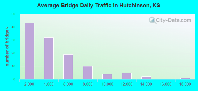
- 416,299Total average daily traffic
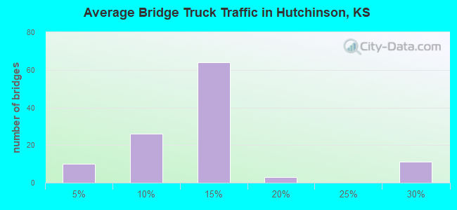
- 40,788Total average daily truck traffic
- National Bridge Inventory (NBI) Registered Bridges for Hutchinson
- No street view available for this location
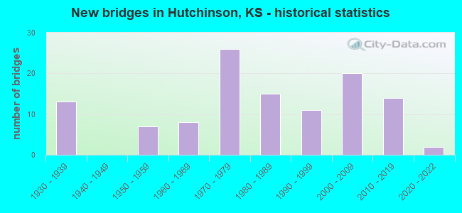
- New bridges - historical statistics
- 131930-1939
- 71950-1959
- 81960-1969
- 261970-1979
- 151980-1989
- 111990-1999
- 202000-2009
- 142010-2019
- 22020-2022
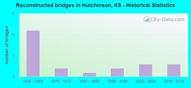
- Reconstructed bridges - Historical Statistics
- 111960-1969
- 21970-1979
- 11980-1989
- 21990-1999
- 32000-2009
- 32010-2019
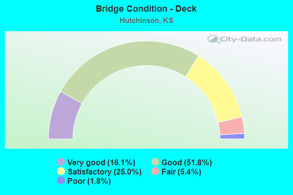
- Bridge Condition - Deck
- 16.1%Very good
- 51.8%Good
- 25.0%Satisfactory
- 5.4%Fair
- 1.8%Poor
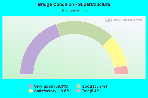
- Bridge Condition - Superstructure
- 39.3%Very good
- 35.7%Good
- 19.6%Satisfactory
- 5.4%Fair
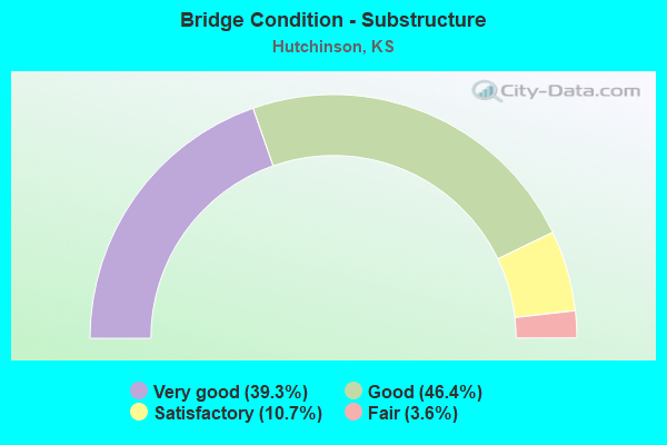
- Bridge Condition - Substructure
- 39.3%Very good
- 46.4%Good
- 10.7%Satisfactory
- 3.6%Fair
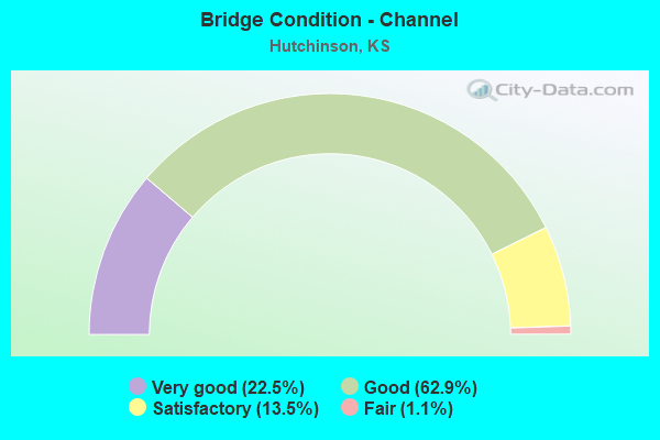
- Bridge Condition - Channel
- 22.5%Very good
- 62.9%Good
- 13.5%Satisfactory
- 1.1%Fair
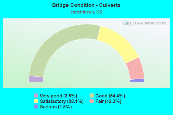
- Bridge Condition - Culverts
- 3.5%Very good
- 54.4%Good
- 28.1%Satisfactory
- 12.3%Fair
- 1.8%Serious
Find on map >> Show street view
Structure Number: 78084, Location: 3.0S OF WILLOW BROOK (Lat: 38.057111, Lng: -97.993625), Route carried "on" structure: County highway 636, Year Built: 1979, Status: Open, Structure Length: 16.86m (55.31ft), Average Daily Traffic: 1,120 (year 2018), Truck Traffic: 10%, Average Future Daily Traffic: 1,345 (year 2040), Design Load: HS 20, Features Intersected: ARKANSAS RIVER
Minimum Vertical Clearance: 30.47m (99.97ft), Kilometerpoint: 0.000, Lanes on structure: 2, Owner: County Highway Agency, Approaching Roadway Width: 13.4m (44.0ft), Skew: 2 degrees, Material/Design: Prestressed concrete continuous, Design/Construction: Tee Beam, Number Of Spans In Main Unit: 9, Length of Maximum Span: 18.6m (61.0ft), Curb-To-Curb Width: 13.4m (44.0ft), Out-to-Out Width: 14.0m (45.9ft)
Condition: Deck: Good, Superstructure: Good, Substructure: Good, Channel: Satisfactory, Operating Rating: 46.3 metric tons, Method Used To Determine Operating Rating: Load Factor (LF), Inventory Rating: 25.7 metric tons, Method Used To Determine Inventory Rating: Load Factor (LF), Structural Evaluation: Equal to present minimum criteria, Deck Geometry: Equal to present desirable criteria, Waterway Adequacy: Equal to present desirable criteria, Approach Roadway Alignment: Better than present minimum criteria, Designated Inspection Frequency: Every 24 months, Inspection Date: June 2020, Deck Structure Type: Concrete Cast-file-Place, Wearing Surface/Protective System: Wearing Surface: Latex Concrete, Deck Protection: Epoxy Coated Reinforcing
Find on map >> Show street view
Structure Number: 78106, Location: 0.9N 1.5W WILLOW BROOK (Lat: 38.114764, Lng: -97.965486), Route carried "on" structure: County highway 2026, Year Built: 1951, Status: Posted for load, Structure Length: 0.76m (2.49ft), Average Daily Traffic: 510 (year 2018), Truck Traffic: 10%, Average Future Daily Traffic: 1,080 (year 2040), Design Load: H 15, Features Intersected: COW CREEK TRIB
Minimum Vertical Clearance: 30.47m (99.97ft), Kilometerpoint: 0.000, Lanes on structure: 2, Owner: County Highway Agency, Approaching Roadway Width: 6.7m (22.0ft), Material/Design: Concrete, Design/Construction: Culvert, Number Of Spans In Main Unit: 3, Length of Maximum Span: 2.4m (7.9ft), Curb-To-Curb Width: 7.9m (25.9ft), Out-to-Out Width: 8.5m (27.9ft)
Condition: Channel: Satisfactory, Culverts: Good, Operating Rating: 27.4 metric tons, Method Used To Determine Operating Rating: Load Factor (LF), Inventory Rating: 16.3 metric tons, Method Used To Determine Inventory Rating: Load Factor (LF), Structural Evaluation: Meets minimum limits, Deck Geometry: Somewhat better than minimum adequacy, Waterway Adequacy: Equal to present minimum criteria, Approach Roadway Alignment: Equal to present desirable criteria, Bridge Posting: Required (Relationship of Operating Rating to Maximum Legal Load: 20.0 - 29.9% below), Designated Inspection Frequency: Every 24 months, Inspection Date: June 2020, Wearing Surface/Protective System: Wearing Surface: Bituminous
Find on map >> Show street view
Structure Number: 78107, Location: 0.4N 1.5E WILLOW BROOK (Lat: 38.112028, Lng: -97.959333), Route carried "on" structure: County highway 2026, Year Built: 1955, Status: Open, Structure Length: 0.62m (2.03ft), Average Daily Traffic: 1,510 (year 2018), Truck Traffic: 10%, Average Future Daily Traffic: 1,810 (year 2040), Design Load: H 15, Features Intersected: COW CREEK TRIB, Facility Carried by Structure: RS 2027 7532685
Minimum Vertical Clearance: 30.47m (99.97ft), Kilometerpoint: 0.000, Lanes on structure: 2, Owner: County Highway Agency, Approaching Roadway Width: 6.7m (22.0ft), Material/Design: Concrete, Design/Construction: Culvert, Number Of Spans In Main Unit: 2, Length of Maximum Span: 3.0m (9.8ft), Curb-To-Curb Width: 7.9m (25.9ft), Out-to-Out Width: 8.2m (26.9ft)
Condition: Channel: Good, Culverts: Satisfactory, Operating Rating: 33.3 metric tons, Method Used To Determine Operating Rating: Load Factor (LF), Inventory Rating: 19.8 metric tons, Method Used To Determine Inventory Rating: Load Factor (LF), Structural Evaluation: Somewhat better than minimum adequacy, Deck Geometry: Meets minimum limits, Waterway Adequacy: Equal to present minimum criteria, Approach Roadway Alignment: Equal to present desirable criteria, Designated Inspection Frequency: Every 24 months, Inspection Date: June 2020, Wearing Surface/Protective System: Wearing Surface: Bituminous
Find on map >> Show street view
Structure Number: 78108, Location: 0.8E OF MEDORA (Lat: 38.148639, Lng: -97.834125), Route carried "on" structure: County highway 2031, Year Built: 1983, Status: Open, Structure Length: 7.68m (25.20ft), Average Daily Traffic: 2,570 (year 2018), Truck Traffic: 10%, Average Future Daily Traffic: 3,085 (year 2040), Design Load: HS 20, Features Intersected: LITTLE ARKANSAS RIVER
Minimum Vertical Clearance: 30.47m (99.97ft), Kilometerpoint: 0.000, Lanes on structure: 2, Owner: County Highway Agency, Approaching Roadway Width: 7.3m (24.0ft), Material/Design: Prestressed concrete continuous, Design/Construction: Tee Beam, Number Of Spans In Main Unit: 5, Length of Maximum Span: 15.8m (51.8ft), Curb-To-Curb Width: 11.0m (36.1ft), Out-to-Out Width: 11.6m (38.1ft)
Condition: Deck: Good, Superstructure: Good, Substructure: Good, Channel: Satisfactory, Operating Rating: 46.8 metric tons, Method Used To Determine Operating Rating: Allowable Stress (AS), Inventory Rating: 35.1 metric tons, Method Used To Determine Inventory Rating: Allowable Stress (AS), Structural Evaluation: Better than present minimum criteria, Deck Geometry: Somewhat better than minimum adequacy, Waterway Adequacy: Equal to present desirable criteria, Approach Roadway Alignment: Better than present minimum criteria, Designated Inspection Frequency: Every 24 months, Inspection Date: July 2020, Deck Structure Type: Concrete Cast-file-Place, Wearing Surface/Protective System: Wearing Surface: Monolithic Concrete, Deck Protection: Epoxy Coated Reinforcing
Find on map >> Show street view
Structure Number: 7811, Location: 2.0W OF HUTCHINSON (Lat: 38.049931, Lng: -97.995667), Route carried "on" structure: County highway 2032, Year Built: 1982, Status: Posted for load, Structure Length: 6.54m (21.46ft), Average Daily Traffic: 1,215 (year 2018), Truck Traffic: 10%, Average Future Daily Traffic: 1,460 (year 2040), Design Load: H 20, Features Intersected: SALT CREEK
Minimum Vertical Clearance: 30.47m (99.97ft), Kilometerpoint: 0.000, Lanes on structure: 2, Owner: County Highway Agency, Approaching Roadway Width: 7.3m (24.0ft), Material/Design: Concrete, Design/Construction: Culvert, Number Of Spans In Main Unit: 20, Length of Maximum Span: 3.0m (9.8ft), Curb-To-Curb Width: 11.0m (36.1ft), Out-to-Out Width: 11.6m (38.1ft)
Condition: Channel: Satisfactory, Culverts: Fair, Operating Rating: 19.3 metric tons, Method Used To Determine Operating Rating: Load Factor (LF), Inventory Rating: 11.5 metric tons, Method Used To Determine Inventory Rating: Load Factor (LF), Structural Evaluation: High priority of replacement, Deck Geometry: Equal to present minimum criteria, Waterway Adequacy: Equal to present minimum criteria, Approach Roadway Alignment: Equal to present desirable criteria, Bridge Posting: Required (Relationship of Operating Rating to Maximum Legal Load: > 39.9% below), Length Of Structure Improvement: 7.01m (23.00ft), Designated Inspection Frequency: Every 24 months, Inspection Date: July 2020, Bridge Improvement Cost: $1,000, Total Project Cost: $1,000 ( Estimate for 2020), Wearing Surface/Protective System: Wearing Surface: Bituminous
Find on map >> Show street view
Structure Number: 78115, Location: 2.0S 5.2W OF BUHLER (Lat: 38.101033, Lng: -97.870733), Route carried "on" structure: County highway 1836, Year Built: 2021, Status: Open, Structure Length: 6.81m (22.34ft), Average Daily Traffic: 1,097 (year 2017), Truck Traffic: 5%, Average Future Daily Traffic: 1,380 (year 2040), Design Load: HS 20, Features Intersected: ST. LOUIS SW. RAILROAD, Facility Carried by Structure: LOCAL CLAY980
Minimum Vertical Clearance: 30.47m (99.97ft), Kilometerpoint: 0.000, Lanes on structure: 2, Owner: County Highway Agency, Approaching Roadway Width: 8.8m (28.9ft), Skew: 2 degrees, Material/Design: Prestressed concrete, Number Of Spans In Main Unit: 3, Length of Maximum Span: 33.5m (109.9ft), Curb or Sidewalk Widths: Left: 0.4m (1.3ft), Right: 0.4m (1.3ft), Curb-To-Curb Width: 9.8m (32.2ft), Out-to-Out Width: 10.5m (34.4ft)
Condition: Deck: Very good, Superstructure: Very good, Substructure: Very good, Operating Rating: 86.2 metric tons, Method Used To Determine Operating Rating: Assigned ratings based on Load and Resistance Factor Design (LRFD) reported in metric tons, Inventory Rating: 51.7 metric tons, Method Used To Determine Inventory Rating: Assigned ratings based on Load and Resistance Factor Design (LRFD) reported in metric tons, Structural Evaluation: Equal to present desirable criteria, Deck Geometry: Somewhat better than minimum adequacy, Underclear: Superior to present desirable criteria, Approach Roadway Alignment: Equal to present desirable criteria, Designated Inspection Frequency: Every 24 months, Inspection Date: September 2021, Deck Structure Type: Concrete Cast-file-Place, Wearing Surface/Protective System: Wearing Surface: Monolithic Concrete, Deck Protection: Epoxy Coated Reinforcing
Find on map >> Show street view
Structure Number: 7807559057, Location: Woodie Seat Freeway (Lat: 38.041783, Lng: -97.938486), Route carried "on" structure: County highway 755, Year Built: 1955, Year Reconstructed: 1977, Status: Posted for load, Structure Length: 31.25m (102.53ft), Average Daily Traffic: 12,000 (year 2006), Truck Traffic: 2%, Average Future Daily Traffic: 14,400 (year 2040), Design Load: H 20, Features Intersected: Arkansas River
Minimum Vertical Clearance: 30.47m (99.97ft), Kilometerpoint: 41.199, Lanes on structure: 2, Owner: County Highway Agency, Approaching Roadway Width: 16.0m (52.5ft), Material/Design: Steel continuous, Design/Construction: Girder and Floorbeam System, Number Of Spans In Main Unit: 17, Length of Maximum Span: 18.3m (60.0ft), Curb or Sidewalk Widths: Left: 1.2m (3.9ft), Right: 1.2m (3.9ft), Curb-To-Curb Width: 15.8m (51.8ft), Out-to-Out Width: 19.0m (62.3ft)
Condition: Deck: Fair, Superstructure: Satisfactory, Substructure: Satisfactory, Channel: Satisfactory, Operating Rating: 28.2 metric tons, Method Used To Determine Operating Rating: Load Factor (LF), Inventory Rating: 16.9 metric tons, Method Used To Determine Inventory Rating: Load Factor (LF), Structural Evaluation: Meets minimum limits, Deck Geometry: Superior to present desirable criteria, Waterway Adequacy: Equal to present desirable criteria, Approach Roadway Alignment: Equal to present desirable criteria, Bridge Posting: Required (Relationship of Operating Rating to Maximum Legal Load: 20.0 - 29.9% below), Designated Inspection Frequency: Every 24 months, Inspection Date: July 2020, Deck Structure Type: Concrete Cast-file-Place, Wearing Surface/Protective System: Wearing Surface: Epoxy Overlay, Deck Protection: Epoxy Coated Reinforcing
Find on map >> Show street view
Structure Number: 78075790576, Location: 2.0S OF HUTCHINSON (Lat: 37.999292, Lng: -97.905417), Route carried "on" structure: County highway , Year Built: 1990, Status: Open, Structure Length: 2.28m (7.48ft), Average Daily Traffic: 48 (year 2006), Truck Traffic: 6%, Average Future Daily Traffic: 60 (year 2040), Features Intersected: SAND CREEK, Facility Carried by Structure: MORGAN AVENUE
Minimum Vertical Clearance: 30.47m (99.97ft), Kilometerpoint: 0.000, Lanes on structure: 2, Owner: County Highway Agency, Approaching Roadway Width: 7.3m (24.0ft), Skew: 3 degrees, Material/Design: Steel continuous, Design/Construction: Stringer/Multi-beam, Number Of Spans In Main Unit: 3, Length of Maximum Span: 7.9m (25.9ft), Curb-To-Curb Width: 8.5m (27.9ft), Out-to-Out Width: 8.6m (28.2ft)
Condition: Deck: Satisfactory, Superstructure: Good, Substructure: Satisfactory, Channel: Satisfactory, Operating Rating: 20.1 metric tons, Method Used To Determine Operating Rating: Load Factor (LF), Inventory Rating: 12.1 metric tons, Method Used To Determine Inventory Rating: Load Factor (LF), Structural Evaluation: Meets minimum limits, Deck Geometry: Better than present minimum criteria, Waterway Adequacy: Better than present minimum criteria, Approach Roadway Alignment: Equal to present desirable criteria, Bridge Posting: Required (Relationship of Operating Rating to Maximum Legal Load: > 39.9% below), Designated Inspection Frequency: Every 24 months, Inspection Date: July 2020, Other Special Inspection Date: March 2021, Deck Structure Type: Corrugated Steel, Wearing Surface/Protective System: Wearing Surface: Bituminous
Find on map >> Show street view
Structure Number: 780761005742, Location: 3.2S 2.3E OF HUTCHINSON (Lat: 38.011069, Lng: -97.885306), Route carried "on" structure: County highway , Year Built: 1982, Status: Open, Structure Length: 2.15m (7.05ft), Average Daily Traffic: 71 (year 2006), Truck Traffic: 10%, Average Future Daily Traffic: 85 (year 2040), Features Intersected: COW CREEK, Facility Carried by Structure: HALSTEAD ST.19.82
Minimum Vertical Clearance: 30.47m (99.97ft), Kilometerpoint: 0.000, Lanes on structure: 2, Owner: County Highway Agency, Approaching Roadway Width: 6.0m (19.7ft), Material/Design: Steel continuous, Design/Construction: Stringer/Multi-beam, Number Of Spans In Main Unit: 2, Length of Maximum Span: 10.6m (34.8ft), Curb-To-Curb Width: 8.4m (27.6ft), Out-to-Out Width: 8.6m (28.2ft)
Condition: Deck: Fair, Superstructure: Fair, Substructure: Satisfactory, Channel: Satisfactory, Operating Rating: 22.8 metric tons, Method Used To Determine Operating Rating: Load Factor (LF), Inventory Rating: 13.6 metric tons, Method Used To Determine Inventory Rating: Load Factor (LF), Structural Evaluation: Meets minimum limits, Deck Geometry: Equal to present minimum criteria, Waterway Adequacy: Better than present minimum criteria, Approach Roadway Alignment: Equal to present desirable criteria, Bridge Posting: Required (Relationship of Operating Rating to Maximum Legal Load: 30.0 - 39.9% below), Designated Inspection Frequency: Every 24 months, Inspection Date: July 2020, Other Special Inspection Date: March 2021, Deck Structure Type: Corrugated Steel, Wearing Surface/Protective System: Wearing Surface: Bituminous
Find on map >> Show street view
Structure Number: 78076150574, Location: 2.0E 2.0S OF HUTCHINSON (Lat: 38.013931, Lng: -97.875736), Route carried "on" structure: County highway , Year Built: 1965, Status: Open, Structure Length: 1.07m (3.51ft), Average Daily Traffic: 31 (year 2006), Truck Traffic: 10%, Average Future Daily Traffic: 35 (year 2040), Design Load: H 15, Features Intersected: DRAIN, Facility Carried by Structure: ILLINOIS RD.33.50
Minimum Vertical Clearance: 30.47m (99.97ft), Kilometerpoint: 0.000, Lanes on structure: 2, Owner: County Highway Agency, Approaching Roadway Width: 6.7m (22.0ft), Material/Design: Concrete, Design/Construction: Culvert, Number Of Spans In Main Unit: 4, Length of Maximum Span: 2.4m (7.9ft), Curb-To-Curb Width: 7.3m (24.0ft), Out-to-Out Width: 7.9m (25.9ft)
Condition: Channel: Good, Culverts: Satisfactory, Operating Rating: 26.1 metric tons, Method Used To Determine Operating Rating: Load Factor (LF), Inventory Rating: 16.2 metric tons, Method Used To Determine Inventory Rating: Load Factor (LF), Structural Evaluation: Somewhat better than minimum adequacy, Deck Geometry: Equal to present minimum criteria, Waterway Adequacy: Better than present minimum criteria, Approach Roadway Alignment: Equal to present desirable criteria, Designated Inspection Frequency: Every 24 months, Inspection Date: July 2020, Wearing Surface/Protective System: Wearing Surface: Gravel
Find on map >> Show street view
Structure Number: 78076320576, Location: 4.6E 4.0S OF HUTCHINSON (Lat: 37.999389, Lng: -97.863167), Route carried "on" structure: County highway , Year Built: 1955, Status: Posted for load, Structure Length: 2.14m (7.02ft), Average Daily Traffic: 61 (year 2006), Truck Traffic: 5%, Average Future Daily Traffic: 75 (year 2040), Features Intersected: COW CREEK, Facility Carried by Structure: STROUD RD.34.20
Minimum Vertical Clearance: 30.47m (99.97ft), Kilometerpoint: 0.000, Lanes on structure: 2, Owner: County Highway Agency, Approaching Roadway Width: 5.7m (18.7ft), Material/Design: Steel continuous, Design/Construction: Stringer/Multi-beam, Number Of Spans In Main Unit: 2, Length of Maximum Span: 10.7m (35.1ft), Curb-To-Curb Width: 6.0m (19.7ft), Out-to-Out Width: 6.3m (20.7ft)
Condition: Deck: Fair, Superstructure: Fair, Substructure: Fair, Channel: Satisfactory, Operating Rating: 11.6 metric tons, Method Used To Determine Operating Rating: Load Factor (LF), Inventory Rating: 6.9 metric tons, Method Used To Determine Inventory Rating: Load Factor (LF), Structural Evaluation: High priority of corrective action, Deck Geometry: Meets minimum limits, Waterway Adequacy: Better than present minimum criteria, Approach Roadway Alignment: Equal to present desirable criteria, Bridge Posting: Required (Relationship of Operating Rating to Maximum Legal Load: > 39.9% below), Length Of Structure Improvement: 2.74m (8.99ft), Designated Inspection Frequency: Every 24 months, Inspection Date: July 2020, Bridge Improvement Cost: $383,000, Roadway Improvement Cost: $43,000, Total Project Cost: $425,000 ( Estimate for 2020), Deck Structure Type: Corrugated Steel, Wearing Surface/Protective System: Wearing Surface: Bituminous
Find on map >> Show street view
Structure Number: 780765005688, Location: S.E. EDGE OF HUTCHINSON (Lat: 38.047750, Lng: -97.848542), Route carried "on" structure: County highway , Year Built: 1965, Status: Open, Structure Length: 0.94m (3.08ft), Average Daily Traffic: 257 (year 2006), Truck Traffic: 5%, Average Future Daily Traffic: 310 (year 2040), Design Load: H 15, Features Intersected: TRIB. TO KISIWA CREEK, Facility Carried by Structure: OBEE RD.22.35
Minimum Vertical Clearance: 30.47m (99.97ft), Kilometerpoint: 0.000, Lanes on structure: 2, Owner: County Highway Agency, Approaching Roadway Width: 7.3m (24.0ft), Material/Design: Prestressed concrete, Design/Construction: Tee Beam, Number Of Spans In Main Unit: 1, Length of Maximum Span: 9.1m (29.9ft), Curb-To-Curb Width: 7.9m (25.9ft), Out-to-Out Width: 8.4m (27.6ft)
Condition: Deck: Satisfactory, Superstructure: Fair, Substructure: Satisfactory, Channel: Satisfactory, Operating Rating: 40.5 metric tons, Method Used To Determine Operating Rating: Allowable Stress (AS), Inventory Rating: 30.6 metric tons, Method Used To Determine Inventory Rating: Allowable Stress (AS), Structural Evaluation: Somewhat better than minimum adequacy, Deck Geometry: Somewhat better than minimum adequacy, Waterway Adequacy: Equal to present minimum criteria, Approach Roadway Alignment: Equal to present desirable criteria, Designated Inspection Frequency: Every 24 months, Inspection Date: July 2020, Deck Structure Type: Concrete Cast-file-Place, Wearing Surface/Protective System: Wearing Surface: Bituminous
Find on map >> Show street view
Structure Number: 780767105562, Location: 1.0E 0.5S OF MEDORA (Lat: 38.141147, Lng: -97.829425), Route carried "on" structure: County highway , Year Built: 1982, Status: Open, Structure Length: 4.63m (15.19ft), Average Daily Traffic: 69 (year 2006), Truck Traffic: 5%, Average Future Daily Traffic: 70 (year 2040), Design Load: H 20, Features Intersected: LITTLE ARKANSAS RIVER, Facility Carried by Structure: MAYFIELD RD.28.75
Minimum Vertical Clearance: 30.47m (99.97ft), Kilometerpoint: 0.000, Lanes on structure: 2, Owner: County Highway Agency, Approaching Roadway Width: 7.3m (24.0ft), Material/Design: Prestressed concrete continuous, Design/Construction: Tee Beam, Number Of Spans In Main Unit: 3, Length of Maximum Span: 15.2m (49.9ft), Curb-To-Curb Width: 8.6m (28.2ft), Out-to-Out Width: 9.2m (30.2ft)
Condition: Deck: Good, Superstructure: Good, Substructure: Good, Channel: Satisfactory, Operating Rating: 39.6 metric tons, Method Used To Determine Operating Rating: Allowable Stress (AS), Inventory Rating: 28.8 metric tons, Method Used To Determine Inventory Rating: Allowable Stress (AS), Structural Evaluation: Better than present minimum criteria, Deck Geometry: Better than present minimum criteria, Waterway Adequacy: Better than present minimum criteria, Approach Roadway Alignment: Better than present minimum criteria, Designated Inspection Frequency: Every 24 months, Inspection Date: July 2020, Deck Structure Type: Concrete Cast-file-Place, Wearing Surface/Protective System: Wearing Surface: Monolithic Concrete
Find on map >> Show street view
Structure Number: 7807691057, Location: 6.5S 3.0W of Buhler (Lat: 38.042917, Lng: -97.810983), Route carried "on" structure: County highway 7822, Year Built: 2019, Status: Open, Structure Length: 0.80m (2.62ft), Average Daily Traffic: 10 (year 2019), Truck Traffic: 10%, Average Future Daily Traffic: 20 (year 2040), Design Load: HS 20, Features Intersected: KISIWA CREEK, Facility Carried by Structure: AVE G 37.05
Minimum Vertical Clearance: 30.47m (99.97ft), Kilometerpoint: 0.000, Lanes on structure: 2, Owner: County Highway Agency, Approaching Roadway Width: 7.3m (24.0ft), Skew: 1 degrees, Material/Design: Steel, Design/Construction: Culvert, Number Of Spans In Main Unit: 4, Length of Maximum Span: 1.8m (5.9ft), Curb-To-Curb Width: 8.5m (27.9ft), Out-to-Out Width: 8.5m (27.9ft)
Condition: Channel: Good, Culverts: Very good, Operating Rating: 54.4 metric tons, Method Used To Determine Operating Rating: Load Factor (LF), Inventory Rating: 32.7 metric tons, Method Used To Determine Inventory Rating: Load Factor (LF), Structural Evaluation: Equal to present desirable criteria, Deck Geometry: Better than present minimum criteria, Waterway Adequacy: Better than present minimum criteria, Approach Roadway Alignment: Equal to present desirable criteria, Designated Inspection Frequency: Every 24 months, Inspection Date: July 2020
Find on map >> Show street view
Structure Number: 413500781080055, Location: W. City Limits (Lat: 38.067700, Lng: -97.967100), Route carried "on" structure: County highway 436, Year Built: 1976, Year Reconstructed: 1999, Status: Open, Structure Length: 18.35m (60.20ft), Average Daily Traffic: 5,540 (year 2006), Truck Traffic: 5%, Average Future Daily Traffic: 6,650 (year 2040), Design Load: H 15, Features Intersected: Cow Crk Diversion Canal
Minimum Vertical Clearance: 30.47m (99.97ft), Kilometerpoint: 45.866, Lanes on structure: 2, Owner: County Highway Agency, Approaching Roadway Width: 6.8m (22.3ft), Skew: 4 degrees, Material/Design: Steel continuous, Design/Construction: Stringer/Multi-beam, Number Of Spans In Main Unit: 17, Length of Maximum Span: 10.7m (35.1ft), Curb-To-Curb Width: 8.5m (27.9ft), Out-to-Out Width: 9.1m (29.9ft)
Condition: Deck: Satisfactory, Superstructure: Good, Substructure: Fair, Channel: Fair, Operating Rating: 51.3 metric tons, Method Used To Determine Operating Rating: Load Factor (LF), Inventory Rating: 30.7 metric tons, Method Used To Determine Inventory Rating: Load Factor (LF), Structural Evaluation: Somewhat better than minimum adequacy, Deck Geometry: Meets minimum limits, Waterway Adequacy: Equal to present desirable criteria, Approach Roadway Alignment: Equal to present desirable criteria, Designated Inspection Frequency: Every 24 months, Inspection Date: June 2020, Deck Structure Type: Concrete Cast-file-Place, Wearing Surface/Protective System: Wearing Surface: Latex Concrete, Deck Protection: Epoxy Coated Reinforcing
Find on map >> Show street view
Structure Number: 413500781808098, Location: Ave. G over G.V.I. (Lat: 38.043086, Lng: -97.876500), Route carried "on" structure: City street 1808, Year Built: 1964, Year Reconstructed: 1987, Status: Posted for load, Structure Length: 1.07m (3.51ft), Average Daily Traffic: 1,730 (year 2015), Truck Traffic: 10%, Average Future Daily Traffic: 2,760 (year 2038), Design Load: H 15, Features Intersected: G. V. I. DITCH, Facility Carried by Structure: 5703350 AVE G
Minimum Vertical Clearance: 30.47m (99.97ft), Kilometerpoint: 0.000, Lanes on structure: 2, Owner: City or Municipal Highway Agency, Approaching Roadway Width: 7.3m (24.0ft), Material/Design: Concrete, Design/Construction: Culvert, Number Of Spans In Main Unit: 4, Length of Maximum Span: 2.4m (7.9ft)
Condition: Channel: Good, Culverts: Satisfactory, Operating Rating: 26.8 metric tons, Method Used To Determine Operating Rating: Load Factor (LF), Inventory Rating: 16.0 metric tons, Method Used To Determine Inventory Rating: Load Factor (LF), Structural Evaluation: Meets minimum limits, Waterway Adequacy: Better than present minimum criteria, Approach Roadway Alignment: Equal to present desirable criteria, Length Of Structure Improvement: 1.71m (5.61ft), Designated Inspection Frequency: Every 24 months, Inspection Date: November 2020, Bridge Improvement Cost: $120,000, Roadway Improvement Cost: $100,000, Total Project Cost: $225,000, Wearing Surface/Protective System: Wearing Surface: Bituminous
Find on map >> Show street view
Structure Number: 413500781808C17, Location: AVENUE G OVER COW CREEK (Lat: 38.042967, Lng: -97.918033), Route carried "on" structure: Business City street 1808, Year Built: 2005, Status: Open, Structure Length: 1.79m (5.87ft), Average Daily Traffic: 2,760 (year 2015), Truck Traffic: 10%, Average Future Daily Traffic: 3,465 (year 2038), Design Load: HS 20, Features Intersected: COW CREEK, Facility Carried by Structure: AVENUE G EAST
Minimum Vertical Clearance: 30.47m (99.97ft), Kilometerpoint: 0.000, Lanes on structure: 2, Owner: City or Municipal Highway Agency, Approaching Roadway Width: 9.1m (29.9ft), Material/Design: Concrete, Design/Construction: Culvert, Number Of Spans In Main Unit: 4, Length of Maximum Span: 4.3m (14.1ft), Curb or Sidewalk Widths: Left: 1.8m (5.9ft), Right: 1.8m (5.9ft)
Condition: Channel: Good, Culverts: Good, Operating Rating: 90.6 metric tons, Method Used To Determine Operating Rating: Load Factor (LF), Inventory Rating: 56.2 metric tons, Method Used To Determine Inventory Rating: Load Factor (LF), Structural Evaluation: Better than present minimum criteria, Waterway Adequacy: Equal to present desirable criteria, Approach Roadway Alignment: Better than present minimum criteria, Designated Inspection Frequency: Every 24 months, Inspection Date: November 2020, Other Special Inspection Date: Febuary 2021, Wearing Surface/Protective System: Wearing Surface: Bituminous
Find on map >> Show street view
Structure Number: 413500781813WSA, Location: Woodie Seat over Ave A (Lat: 38.051000, Lng: -97.937606), Route carried "on" structure: City street 1813, Year Built: 1958, Status: Open, Structure Length: 5.21m (17.09ft), Average Daily Traffic: 10,180 (year 2015), Truck Traffic: 4%, Average Future Daily Traffic: 18,620 (year 2038), Design Load: HS 20, Features Intersected: AVENUE "A", Facility Carried by Structure: Woodie Seat Fwy
Minimum Vertical Clearance: 30.47m (99.97ft), Kilometerpoint: 0.000, Lanes on structure: 2, Lanes under structure: 4, Owner: City or Municipal Highway Agency, Approaching Roadway Width: 17.7m (58.1ft), Skew: 20 degrees, Material/Design: Concrete continuous, Design/Construction: Slab, Number Of Spans In Main Unit: 4, Length of Maximum Span: 14.6m (47.9ft), Curb-To-Curb Width: 17.7m (58.1ft), Out-to-Out Width: 19.4m (63.6ft)
Condition: Deck: Satisfactory, Superstructure: Satisfactory, Substructure: Good, Operating Rating: 41.7 metric tons, Method Used To Determine Operating Rating: Load Factor (LF), Inventory Rating: 25.1 metric tons, Method Used To Determine Inventory Rating: Load Factor (LF), Structural Evaluation: Equal to present minimum criteria, Deck Geometry: Superior to present desirable criteria, Underclear: Equal to present minimum criteria, Approach Roadway Alignment: Somewhat better than minimum adequacy, Length Of Structure Improvement: 6.25m (20.51ft), Designated Inspection Frequency: Every 24 months, Inspection Date: December 2020, Bridge Improvement Cost: $800,000, Roadway Improvement Cost: $110,000, Total Project Cost: $1,000,000, Deck Structure Type: Concrete Cast-file-Place, Wearing Surface/Protective System: Wearing Surface: Low Slump Concrete
Find on map >> Show street view
Structure Number: 413500781813WSB, Location: Woodie Seat over Ave B (Lat: 38.049692, Lng: -97.937611), Route carried "on" structure: City street 1813, Year Built: 1959, Status: Open, Structure Length: 5.21m (17.09ft), Average Daily Traffic: 10,180 (year 2015), Truck Traffic: 4%, Average Future Daily Traffic: 18,620 (year 2038), Design Load: HS 20, Features Intersected: AVENUE "B", Facility Carried by Structure: Woodie Seat Fwy
Minimum Vertical Clearance: 30.47m (99.97ft), Kilometerpoint: 0.000, Lanes on structure: 4, Lanes under structure: 4, Owner: City or Municipal Highway Agency, Approaching Roadway Width: 17.7m (58.1ft), Skew: 20 degrees, Material/Design: Concrete continuous, Design/Construction: Tee Beam, Number Of Spans In Main Unit: 4, Length of Maximum Span: 14.9m (48.9ft), Curb-To-Curb Width: 17.7m (58.1ft), Out-to-Out Width: 19.4m (63.6ft)
Condition: Deck: Poor, Superstructure: Satisfactory, Substructure: Good, Operating Rating: 22.1 metric tons, Method Used To Determine Operating Rating: Load Factor (LF), Inventory Rating: 13.1 metric tons, Method Used To Determine Inventory Rating: Load Factor (LF), Structural Evaluation: High priority of replacement, Deck Geometry: Somewhat better than minimum adequacy, Underclear: Superior to present desirable criteria, Approach Roadway Alignment: Better than present minimum criteria, Length Of Structure Improvement: 6.25m (20.51ft), Designated Inspection Frequency: Every 24 months, Inspection Date: November 2020, Bridge Improvement Cost: $800,000, Roadway Improvement Cost: $110,000, Total Project Cost: $1,000,000, Deck Structure Type: Concrete Cast-file-Place, Wearing Surface/Protective System: Wearing Surface: Other
Find on map >> Show street view
Structure Number: 413500781813WSC, Location: Woodie Seat over Ave C (Lat: 38.048400, Lng: -97.937586), Route carried "on" structure: City street 1813, Year Built: 1959, Status: Open, Structure Length: 6.05m (19.85ft), Average Daily Traffic: 10,180 (year 2015), Truck Traffic: 4%, Average Future Daily Traffic: 18,620 (year 2038), Design Load: H 20, Features Intersected: K&O R.R., AVENUE "C", Facility Carried by Structure: Woodie Seat Fwy
Minimum Vertical Clearance: 30.47m (99.97ft), Kilometerpoint: 0.000, Lanes on structure: 4, Lanes under structure: 2, Owner: City or Municipal Highway Agency, Approaching Roadway Width: 17.7m (58.1ft), Skew: 20 degrees, Material/Design: Concrete continuous, Design/Construction: Slab, Number Of Spans In Main Unit: 4, Length of Maximum Span: 17.1m (56.1ft), Curb-To-Curb Width: 16.5m (54.1ft), Out-to-Out Width: 18.1m (59.4ft)
Condition: Deck: Satisfactory, Superstructure: Satisfactory, Substructure: Good, Operating Rating: 38.3 metric tons, Method Used To Determine Operating Rating: Load Factor (LF), Inventory Rating: 23.0 metric tons, Method Used To Determine Inventory Rating: Load Factor (LF), Structural Evaluation: Somewhat better than minimum adequacy, Deck Geometry: Meets minimum limits, Underclear: Superior to present desirable criteria, Approach Roadway Alignment: Better than present minimum criteria, Length Of Structure Improvement: 7.28m (23.88ft), Designated Inspection Frequency: Every 24 months, Inspection Date: November 2020, Bridge Improvement Cost: $800,000, Roadway Improvement Cost: $110,000, Total Project Cost: $970,000, Deck Structure Type: Concrete Cast-file-Place, Wearing Surface/Protective System: Wearing Surface: Low Slump Concrete
Find on map >> Show street view
Structure Number: 413500781813WSD, Location: Woodie Seat over Ave D (Lat: 38.047158, Lng: -97.937589), Route carried "on" structure: City street 1813, Year Built: 2004, Status: Open, Structure Length: 7.21m (23.65ft), Average Daily Traffic: 10,180 (year 2015), Truck Traffic: 4%, Average Future Daily Traffic: 18,620 (year 2038), Design Load: HS 20, Features Intersected: U.P. RR, AVENUE "D", Facility Carried by Structure: Woodie Seat Fwy
Minimum Vertical Clearance: 30.47m (99.97ft), Kilometerpoint: 0.000, Lanes on structure: 4, Lanes under structure: 2, Owner: City or Municipal Highway Agency, Approaching Roadway Width: 17.4m (57.1ft), Skew: 20 degrees, Material/Design: Steel continuous, Design/Construction: Stringer/Multi-beam, Number Of Spans In Main Unit: 3, Length of Maximum Span: 27.4m (89.9ft), Curb-To-Curb Width: 17.4m (57.1ft), Out-to-Out Width: 19.1m (62.7ft)
Condition: Deck: Good, Superstructure: Very good, Substructure: Good, Operating Rating: 45.9 metric tons, Method Used To Determine Operating Rating: Load Factor (LF), Inventory Rating: 27.5 metric tons, Method Used To Determine Inventory Rating: Load Factor (LF), Structural Evaluation: Equal to present minimum criteria, Deck Geometry: Somewhat better than minimum adequacy, Underclear: Meets minimum limits, Approach Roadway Alignment: Better than present minimum criteria, Length Of Structure Improvement: 8.65m (28.38ft), Designated Inspection Frequency: Every 24 months, Inspection Date: November 2020, Bridge Improvement Cost: $125,000, Roadway Improvement Cost: $110,000, Total Project Cost: $250,000, Deck Structure Type: Concrete Cast-file-Place, Wearing Surface/Protective System: Wearing Surface: Latex Concrete, Deck Protection: Epoxy Coated Reinforcing
Find on map >> Show street view
Structure Number: 413500781813WSF, Location: Woodie Seat over Ave. F (Lat: 38.044536, Lng: -97.937611), Route carried "on" structure: City street 1813, Year Built: 2004, Status: Open, Structure Length: 4.67m (15.32ft), Average Daily Traffic: 10,180 (year 2015), Truck Traffic: 4%, Average Future Daily Traffic: 18,620 (year 2038), Design Load: HS 20, Features Intersected: AVENUE "F", Facility Carried by Structure: Woodie Seat Fwy
Minimum Vertical Clearance: 30.47m (99.97ft), Kilometerpoint: 0.000, Lanes on structure: 3, Lanes under structure: 2, Owner: City or Municipal Highway Agency, Approaching Roadway Width: 18.1m (59.4ft), Skew: 20 degrees, Material/Design: Concrete continuous, Design/Construction: Slab, Number Of Spans In Main Unit: 3, Length of Maximum Span: 18.3m (60.0ft), Curb-To-Curb Width: 18.1m (59.4ft), Out-to-Out Width: 19.7m (64.6ft)
Condition: Deck: Good, Superstructure: Good, Substructure: Very good, Operating Rating: 81.6 metric tons, Method Used To Determine Operating Rating: Load Factor (LF), Inventory Rating: 48.8 metric tons, Method Used To Determine Inventory Rating: Load Factor (LF), Structural Evaluation: Better than present minimum criteria, Deck Geometry: Superior to present desirable criteria, Underclear: Meets minimum limits, Approach Roadway Alignment: Better than present minimum criteria, Length Of Structure Improvement: 5.60m (18.37ft), Designated Inspection Frequency: Every 24 months, Inspection Date: November 2020, Bridge Improvement Cost: $832,000, Roadway Improvement Cost: $110,000, Total Project Cost: $952,000, Deck Structure Type: Concrete Cast-file-Place, Wearing Surface/Protective System: Deck Protection: Epoxy Coated Reinforcing
Find on map >> Show street view
Structure Number: 413500781815C08, Location: Adams St. over Cow Creek (Lat: 38.051775, Lng: -97.935439), Route carried "on" structure: City street 1815, Year Built: 1981, Status: Open, Structure Length: 0.81m (2.66ft), Average Daily Traffic: 9,360 (year 2015), Truck Traffic: 3%, Average Future Daily Traffic: 16,311 (year 2038), Design Load: H 20, Features Intersected: COW CREEK, Facility Carried by Structure: ADAMS STREET
Minimum Vertical Clearance: 30.47m (99.97ft), Kilometerpoint: 0.000, Lanes on structure: 4, Owner: City or Municipal Highway Agency, Approaching Roadway Width: 13.6m (44.6ft), Skew: 3 degrees, Material/Design: Concrete, Design/Construction: Culvert, Number Of Spans In Main Unit: 1, Length of Maximum Span: 8.1m (26.6ft), Curb or Sidewalk Widths: Left: 1.2m (3.9ft), Right: 1.2m (3.9ft)
Condition: Channel: Good, Culverts: Fair, Operating Rating: 49.3 metric tons, Method Used To Determine Operating Rating: Load Factor (LF), Inventory Rating: 29.4 metric tons, Method Used To Determine Inventory Rating: Load Factor (LF), Structural Evaluation: Somewhat better than minimum adequacy, Waterway Adequacy: Equal to present desirable criteria, Approach Roadway Alignment: Equal to present desirable criteria, Length Of Structure Improvement: 0.84m (2.76ft), Designated Inspection Frequency: Every 24 months, Inspection Date: January 2021, Bridge Improvement Cost: $87,000, Roadway Improvement Cost: $110,000, Total Project Cost: $198,000, Wearing Surface/Protective System: Wearing Surface: Bituminous
Find on map >> Show street view
Structure Number: 413500781816C9A, Location: AVE A AT WASHINGTON (Lat: 38.050817, Lng: -97.933458), Route carried "on" structure: Business City street 1816, Year Built: 1996, Status: Open, Structure Length: 1.84m (6.04ft), Average Daily Traffic: 6,300 (year 2015), Truck Traffic: 10%, Average Future Daily Traffic: 8,700 (year 2038), Design Load: HS 20, Features Intersected: COW CREEK, Facility Carried by Structure: AVENUE A AND WASH.
Minimum Vertical Clearance: 30.47m (99.97ft), Kilometerpoint: 0.000, Lanes on structure: 4, Owner: City or Municipal Highway Agency, Approaching Roadway Width: 17.4m (57.1ft), Skew: 6 degrees, Material/Design: Concrete, Design/Construction: Culvert, Number Of Spans In Main Unit: 3, Length of Maximum Span: 5.9m (19.4ft)
Condition: Channel: Good, Culverts: Good, Operating Rating: 90.6 metric tons, Method Used To Determine Operating Rating: Load Factor (LF), Inventory Rating: 62.3 metric tons, Method Used To Determine Inventory Rating: Load Factor (LF), Structural Evaluation: Better than present minimum criteria, Waterway Adequacy: Equal to present desirable criteria, Approach Roadway Alignment: Equal to present desirable criteria, Designated Inspection Frequency: Every 24 months, Inspection Date: November 2020, Wearing Surface/Protective System: Wearing Surface: Bituminous
Find on map >> Show street view
Structure Number: 413500781816C9D, Location: MAIN ST AT AVE. A (Lat: 38.050650, Lng: -97.931889), Route carried "on" structure: Business City street 1816, Year Built: 1996, Status: Open, Structure Length: 1.28m (4.20ft), Average Daily Traffic: 7,545 (year 2015), Truck Traffic: 10%, Average Future Daily Traffic: 9,450 (year 2038), Design Load: HS 20, Features Intersected: COW CREEK, Facility Carried by Structure: MAIN ST
Minimum Vertical Clearance: 30.47m (99.97ft), Kilometerpoint: 0.000, Lanes on structure: 4, Owner: City or Municipal Highway Agency, Approaching Roadway Width: 14.5m (47.6ft), Skew: 10 degrees, Material/Design: Concrete, Design/Construction: Slab, Number Of Spans In Main Unit: 1, Length of Maximum Span: 12.2m (40.0ft), Curb or Sidewalk Widths: Left: 3.7m (12.1ft), Right: 3.7m (12.1ft), Curb-To-Curb Width: 14.6m (47.9ft), Out-to-Out Width: 26.0m (85.3ft)
Condition: Deck: Good, Superstructure: Good, Substructure: Good, Channel: Very good, Operating Rating: 67.4 metric tons, Method Used To Determine Operating Rating: Load Factor (LF), Inventory Rating: 40.4 metric tons, Method Used To Determine Inventory Rating: Load Factor (LF), Structural Evaluation: Better than present minimum criteria, Deck Geometry: High priority of replacement, Waterway Adequacy: Equal to present desirable criteria, Approach Roadway Alignment: Equal to present desirable criteria, Length Of Structure Improvement: 1.54m (5.05ft), Designated Inspection Frequency: Every 24 months, Inspection Date: November 2020, Bridge Improvement Cost: $301,000, Roadway Improvement Cost: $110,000, Total Project Cost: $412,000, Deck Structure Type: Concrete Cast-file-Place, Wearing Surface/Protective System: Deck Protection: Epoxy Coated Reinforcing
Find on map >> Show street view
Structure Number: 413500781819C14, Location: MAPLE ST OVER COW CREEK (Lat: 38.048233, Lng: -97.926317), Route carried "on" structure: Business City street 1819, Year Built: 1993, Status: Open, Structure Length: 1.62m (5.31ft), Average Daily Traffic: 1,515 (year 2015), Truck Traffic: 10%, Average Future Daily Traffic: 2,780 (year 2038), Design Load: HS 20, Features Intersected: COW CREEK, Facility Carried by Structure: MAPLE STREET
Minimum Vertical Clearance: 30.47m (99.97ft), Kilometerpoint: 0.000, Lanes on structure: 2, Owner: City or Municipal Highway Agency, Approaching Roadway Width: 10.0m (32.8ft), Skew: 1 degrees, Material/Design: Concrete, Design/Construction: Culvert, Number Of Spans In Main Unit: 6, Length of Maximum Span: 2.5m (8.2ft), Curb or Sidewalk Widths: Left: 1.8m (5.9ft), Right: 1.8m (5.9ft)
Condition: Channel: Good, Culverts: Good, Operating Rating: 62.5 metric tons, Method Used To Determine Operating Rating: Load Factor (LF), Inventory Rating: 37.4 metric tons, Method Used To Determine Inventory Rating: Load Factor (LF), Structural Evaluation: Better than present minimum criteria, Waterway Adequacy: Better than present minimum criteria, Approach Roadway Alignment: Equal to present desirable criteria, Designated Inspection Frequency: Every 24 months, Inspection Date: November 2020, Wearing Surface/Protective System: Wearing Surface: Bituminous
Find on map >> Show street view
Structure Number: 413500781820002, Location: W. HUTCHINSON LIMITS (Lat: 38.057208, Lng: -97.966792), Route carried "on" structure: County highway 1820, Year Built: 1987, Year Reconstructed: 2012, Status: Open, Structure Length: 13.32m (43.70ft), Average Daily Traffic: 1,834 (year 2018), Truck Traffic: 10%, Average Future Daily Traffic: 2,200 (year 2040), Design Load: HS 20, Features Intersected: COW CREEK DIVERSION, Facility Carried by Structure: 4th Ave
Minimum Vertical Clearance: 30.47m (99.97ft), Kilometerpoint: 0.000, Lanes on structure: 2, Owner: County Highway Agency, Approaching Roadway Width: 7.3m (24.0ft), Material/Design: Concrete continuous, Design/Construction: Slab, Number Of Spans In Main Unit: 9, Length of Maximum Span: 15.5m (50.9ft), Curb-To-Curb Width: 12.2m (40.0ft), Out-to-Out Width: 12.8m (42.0ft)
Condition: Deck: Satisfactory, Superstructure: Satisfactory, Substructure: Satisfactory, Channel: Satisfactory, Operating Rating: 76.2 metric tons, Method Used To Determine Operating Rating: Load Factor (LF), Inventory Rating: 45.5 metric tons, Method Used To Determine Inventory Rating: Load Factor (LF), Structural Evaluation: Equal to present minimum criteria, Deck Geometry: Better than present minimum criteria, Waterway Adequacy: Better than present minimum criteria, Approach Roadway Alignment: Equal to present desirable criteria, Designated Inspection Frequency: Every 24 months, Inspection Date: June 2020, Deck Structure Type: Concrete Cast-file-Place, Wearing Surface/Protective System: Wearing Surface: Monolithic Concrete, Deck Protection: Epoxy Coated Reinforcing
Find on map >> Show street view
Structure Number: 413500781820C05, Location: 4TH. AVE. OVER AT&SF R.R. (Lat: 38.057367, Lng: -97.942361), Route carried "on" structure: City street 1820, Year Built: 1935, Year Reconstructed: 1982, Status: Open, Structure Length: 25.69m (84.28ft), Average Daily Traffic: 4,630 (year 2015), Truck Traffic: 10%, Average Future Daily Traffic: 8,740 (year 2038), Design Load: HS 20, Features Intersected: COW CREEK:AT&SF RAILROAD, Facility Carried by Structure: 4TH. AVENUE
Minimum Vertical Clearance: 30.47m (99.97ft), Kilometerpoint: 0.000, Lanes on structure: 4, Owner: City or Municipal Highway Agency, Approaching Roadway Width: 13.5m (44.3ft), Material/Design: Steel continuous, Design/Construction: Stringer/Multi-beam, Number Of Spans In Main Unit: 10, Length of Maximum Span: 35.7m (117.1ft), Curb or Sidewalk Widths: Left: 1.2m (3.9ft), Right: 1.2m (3.9ft), Curb-To-Curb Width: 14.0m (45.9ft), Out-to-Out Width: 17.9m (58.7ft)
Condition: Deck: Good, Superstructure: Good, Substructure: Good, Channel: Very good, Operating Rating: 50.3 metric tons, Method Used To Determine Operating Rating: Load Factor (LF), Inventory Rating: 28.7 metric tons, Method Used To Determine Inventory Rating: Load Factor (LF), Structural Evaluation: Better than present minimum criteria, Deck Geometry: High priority of replacement, Underclear: Meets minimum limits, Waterway Adequacy: Equal to present desirable criteria, Approach Roadway Alignment: Equal to present minimum criteria, Length Of Structure Improvement: 25.57m (83.89ft), Designated Inspection Frequency: Every 24 months, Critical Feature Inspection Frequency: Every 24 months, Inspection Date: November 2020, Critical Feature Inspection Date: May 2021, Bridge Improvement Cost: $301,000, Roadway Improvement Cost: $301,000, Total Project Cost: $451,000, Deck Structure Type: Concrete Cast-file-Place, Wearing Surface/Protective System: Wearing Surface: Low Slump Concrete
Find on map >> Show street view
Structure Number: 413500781820E56, Location: FOURTH AVE. & E.S.D. (Lat: 38.057683, Lng: -97.896194), Route carried "on" structure: City street 1820, Year Built: 1999, Status: Open, Structure Length: 1.29m (4.23ft), Average Daily Traffic: 7,335 (year 2015), Truck Traffic: 10%, Average Future Daily Traffic: 9,350 (year 2038), Design Load: HS 20, Features Intersected: EAST SIDE DRAIN, Facility Carried by Structure: FOURTH AVENUE
Minimum Vertical Clearance: 30.47m (99.97ft), Kilometerpoint: 0.000, Lanes on structure: 2, Owner: City or Municipal Highway Agency, Approaching Roadway Width: 13.9m (45.6ft), Material/Design: Concrete, Design/Construction: Culvert, Number Of Spans In Main Unit: 4, Length of Maximum Span: 3.0m (9.8ft), Curb or Sidewalk Widths: Left: 1.5m (4.9ft), Right: 1.5m (4.9ft)
Condition: Channel: Good, Culverts: Good, Operating Rating: 71.6 metric tons, Method Used To Determine Operating Rating: Load Factor (LF), Inventory Rating: 42.9 metric tons, Method Used To Determine Inventory Rating: Load Factor (LF), Structural Evaluation: Better than present minimum criteria, Waterway Adequacy: Equal to present desirable criteria, Approach Roadway Alignment: Equal to present desirable criteria, Designated Inspection Frequency: Every 24 months, Inspection Date: November 2020, Wearing Surface/Protective System: Wearing Surface: Monolithic Concrete
Find on map >> Show street view
Structure Number: 413500781820G24, Location: E 4TH AVE OVER GVI (Lat: 38.057681, Lng: -97.875611), Route carried "on" structure: City street 1820, Year Built: 1979, Status: Open, Structure Length: 0.89m (2.92ft), Average Daily Traffic: 6,475 (year 2015), Truck Traffic: 10%, Average Future Daily Traffic: 9,620 (year 2038), Features Intersected: GVI DRAINAGE SYSTEM, Facility Carried by Structure: E 4TH AVE
Minimum Vertical Clearance: 30.47m (99.97ft), Kilometerpoint: 0.000, Lanes on structure: 3, Owner: City or Municipal Highway Agency, Approaching Roadway Width: 11.0m (36.1ft), Skew: 1 degrees, Material/Design: Concrete, Design/Construction: Culvert, Number Of Spans In Main Unit: 3, Length of Maximum Span: 2.8m (9.2ft)
Condition: Channel: Good, Culverts: Satisfactory, Operating Rating: 30.6 metric tons, Method Used To Determine Operating Rating: Field evaluation and documented engineering judgment, Inventory Rating: 14.4 metric tons, Method Used To Determine Inventory Rating: Field evaluation and documented engineering judgment, Structural Evaluation: High priority of corrective action, Waterway Adequacy: Equal to present desirable criteria, Approach Roadway Alignment: Equal to present desirable criteria, Designated Inspection Frequency: Every 24 months, Inspection Date: November 2020, Wearing Surface/Protective System: Wearing Surface: Bituminous
Find on map >> Show street view
Structure Number: 413500781820H02, Location: 4TH AVE OVER HARSHA CANAL (Lat: 38.057000, Lng: -97.947944), Route carried "on" structure: City street 1820, Year Built: 2003, Status: Open, Structure Length: 5.08m (16.67ft), Average Daily Traffic: 4,515 (year 2015), Truck Traffic: 10%, Average Future Daily Traffic: 5,650 (year 2038), Design Load: HS 20, Features Intersected: HARSHA CANAL, Facility Carried by Structure: 4TH. AVENUE
Minimum Vertical Clearance: 30.47m (99.97ft), Kilometerpoint: 0.000, Lanes on structure: 4, Owner: City or Municipal Highway Agency, Approaching Roadway Width: 14.5m (47.6ft), Material/Design: Concrete continuous, Design/Construction: Slab, Number Of Spans In Main Unit: 3, Length of Maximum Span: 20.0m (65.6ft), Curb or Sidewalk Widths: Left: 3.3m (10.8ft), Right: 2.1m (6.9ft), Curb-To-Curb Width: 14.5m (47.6ft), Out-to-Out Width: 20.7m (67.9ft)
Condition: Deck: Good, Superstructure: Good, Substructure: Good, Channel: Very good, Operating Rating: 79.7 metric tons, Method Used To Determine Operating Rating: Load Factor (LF), Inventory Rating: 47.6 metric tons, Method Used To Determine Inventory Rating: Load Factor (LF), Structural Evaluation: Better than present minimum criteria, Deck Geometry: High priority of replacement, Waterway Adequacy: Equal to present desirable criteria, Approach Roadway Alignment: Equal to present desirable criteria, Length Of Structure Improvement: 6.10m (20.01ft), Designated Inspection Frequency: Every 24 months, Inspection Date: November 2020, Bridge Improvement Cost: $800,000, Roadway Improvement Cost: $110,000, Total Project Cost: $1,000,000, Deck Structure Type: Concrete Cast-file-Place, Wearing Surface/Protective System: Deck Protection: Epoxy Coated Reinforcing
Find on map >> Show street view
Structure Number: 413500781820S01, Location: 4TH AVENUE OVER MONROE ST (Lat: 38.057564, Lng: -97.940572), Route carried "on" structure: City street 1820, Year Built: 1939, Year Reconstructed: 2010, Status: Open, Structure Length: 1.33m (4.36ft), Average Daily Traffic: 4,630 (year 2015), Truck Traffic: 10%, Average Future Daily Traffic: 8,740 (year 2038), Design Load: HL 93, Features Intersected: MONROE STREET, Facility Carried by Structure: 4TH. AVENUE
Minimum Vertical Clearance: 30.47m (99.97ft), Kilometerpoint: 0.000, Lanes on structure: 4, Lanes under structure: 2, Owner: City or Municipal Highway Agency, Approaching Roadway Width: 12.8m (42.0ft), Material/Design: Prestressed concrete, Design/Construction: Tee Beam, Number Of Spans In Main Unit: 1, Length of Maximum Span: 12.8m (42.0ft), Curb or Sidewalk Widths: Left: 1.5m (4.9ft), Right: 1.5m (4.9ft), Curb-To-Curb Width: 13.1m (43.0ft), Out-to-Out Width: 17.6m (57.7ft)
Condition: Deck: Good, Superstructure: Very good, Substructure: Good, Operating Rating: 90.6 metric tons, Method Used To Determine Operating Rating: Load Factor (LF), Inventory Rating: 74.1 metric tons, Method Used To Determine Inventory Rating: Load Factor (LF), Structural Evaluation: Better than present minimum criteria, Deck Geometry: High priority of replacement, Underclear: Meets minimum limits, Approach Roadway Alignment: Equal to present desirable criteria, Length Of Structure Improvement: 1.57m (5.15ft), Designated Inspection Frequency: Every 24 months, Inspection Date: November 2020, Bridge Improvement Cost: $250,000, Roadway Improvement Cost: $25,000, Total Project Cost: $350,000, Deck Structure Type: Concrete Cast-file-Place, Wearing Surface/Protective System: Deck Protection: Epoxy Coated Reinforcing
Find on map >> Show street view
Structure Number: 413500781821157, Location: 4.7N 1.0W K61-US50 JCT. (Lat: 38.097222, Lng: -97.922056), Route carried "on" structure: City street 1821, Year Built: 1997, Status: Open, Structure Length: 0.65m (2.13ft), Average Daily Traffic: 6,000 (year 2015), Truck Traffic: 16%, Average Future Daily Traffic: 6,804 (year 2038), Features Intersected: GVI DITCH, Facility Carried by Structure: N Plum St
Minimum Vertical Clearance: 30.47m (99.97ft), Kilometerpoint: 0.000, Lanes on structure: 2, Owner: City or Municipal Highway Agency, Approaching Roadway Width: 11.0m (36.1ft), Material/Design: Concrete, Design/Construction: Culvert, Number Of Spans In Main Unit: 2, Length of Maximum Span: 3.0m (9.8ft)
Condition: Channel: Good, Culverts: Good, Operating Rating: 56.2 metric tons, Method Used To Determine Operating Rating: Load Factor (LF), Inventory Rating: 33.7 metric tons, Method Used To Determine Inventory Rating: Load Factor (LF), Structural Evaluation: Better than present minimum criteria, Waterway Adequacy: Equal to present minimum criteria, Approach Roadway Alignment: Equal to present desirable criteria, Designated Inspection Frequency: Every 24 months, Inspection Date: November 2020, Wearing Surface/Protective System: Wearing Surface: Bituminous
Find on map >> Show street view
Structure Number: 413500781821C15, Location: PLUM ST. OVER COW CREEK (Lat: 38.046142, Lng: -97.922461), Route carried "on" structure: Business City street 1821, Year Built: 2003, Status: Open, Structure Length: 2.06m (6.76ft), Average Daily Traffic: 3,715 (year 2015), Truck Traffic: 10%, Average Future Daily Traffic: 2,190 (year 2038), Design Load: HS 20, Features Intersected: COW CREEK, Facility Carried by Structure: PLUM STREET
Minimum Vertical Clearance: 30.47m (99.97ft), Kilometerpoint: 0.000, Lanes on structure: 2, Owner: City or Municipal Highway Agency, Approaching Roadway Width: 12.1m (39.7ft), Skew: 3 degrees, Material/Design: Concrete, Design/Construction: Culvert, Number Of Spans In Main Unit: 4, Length of Maximum Span: 4.9m (16.1ft), Curb or Sidewalk Widths: Left: 3.0m (9.8ft), Right: 1.5m (4.9ft)
Condition: Channel: Good, Culverts: Good, Operating Rating: 88.6 metric tons, Method Used To Determine Operating Rating: Load Factor (LF), Inventory Rating: 53.1 metric tons, Method Used To Determine Inventory Rating: Load Factor (LF), Structural Evaluation: Better than present minimum criteria, Waterway Adequacy: Equal to present desirable criteria, Approach Roadway Alignment: Equal to present desirable criteria, Designated Inspection Frequency: Every 24 months, Inspection Date: November 2020, Other Special Inspection Date: Febuary 2021, Wearing Surface/Protective System: Wearing Surface: Bituminous
Find on map >> Show street view
Structure Number: 413500781821E1, Location: PLUM ST. @ CHEROKEE (Lat: 38.088433, Lng: -97.922064), Route carried "on" structure: Business City street 1821, Year Built: 1981, Status: Open, Structure Length: 0.70m (2.30ft), Average Daily Traffic: 8,660 (year 2015), Truck Traffic: 10%, Average Future Daily Traffic: 12,342 (year 2038), Design Load: H 20, Features Intersected: EAST SIDE DRAIN, Facility Carried by Structure: PLUM ST.
Minimum Vertical Clearance: 30.47m (99.97ft), Kilometerpoint: 0.000, Lanes on structure: 4, Owner: City or Municipal Highway Agency, Approaching Roadway Width: 15.7m (51.5ft), Skew: 4 degrees, Material/Design: Concrete, Design/Construction: Culvert, Number Of Spans In Main Unit: 2, Length of Maximum Span: 3.4m (11.2ft), Curb or Sidewalk Widths: Left: 1.8m (5.9ft), Right: 1.2m (3.9ft)
Condition: Channel: Good, Culverts: Good, Operating Rating: 39.9 metric tons, Method Used To Determine Operating Rating: Load Factor (LF), Inventory Rating: 23.9 metric tons, Method Used To Determine Inventory Rating: Load Factor (LF), Structural Evaluation: Somewhat better than minimum adequacy, Waterway Adequacy: Equal to present desirable criteria, Approach Roadway Alignment: Equal to present desirable criteria, Length Of Structure Improvement: 1.20m (3.94ft), Designated Inspection Frequency: Every 24 months, Inspection Date: November 2020, Bridge Improvement Cost: $241,000, Roadway Improvement Cost: $24,000, Total Project Cost: $266,000, Wearing Surface/Protective System: Wearing Surface: Bituminous
Find on map >> Show street view
Structure Number: 413500781822C04, Location: 5th Ave. over Cow Creek (Lat: 38.058472, Lng: -97.944111), Route carried "on" structure: City street 1822, Year Built: 1973, Status: Open, Structure Length: 2.22m (7.28ft), Average Daily Traffic: 4,540 (year 2015), Truck Traffic: 5%, Average Future Daily Traffic: 9,878 (year 2038), Design Load: HS 20, Features Intersected: COW CREEK, Facility Carried by Structure: 5th Ave.
Minimum Vertical Clearance: 30.47m (99.97ft), Kilometerpoint: 0.000, Lanes on structure: 2, Owner: City or Municipal Highway Agency, Approaching Roadway Width: 9.8m (32.2ft), Skew: 2 degrees, Material/Design: Concrete continuous, Design/Construction: Slab, Number Of Spans In Main Unit: 3, Length of Maximum Span: 9.1m (29.9ft), Curb or Sidewalk Widths: Left: 1.2m (3.9ft), Right: 1.2m (3.9ft), Curb-To-Curb Width: 9.8m (32.2ft), Out-to-Out Width: 13.5m (44.3ft)
Condition: Deck: Satisfactory, Superstructure: Satisfactory, Substructure: Good, Channel: Good, Operating Rating: 61.9 metric tons, Method Used To Determine Operating Rating: Load Factor (LF), Inventory Rating: 37.0 metric tons, Method Used To Determine Inventory Rating: Load Factor (LF), Structural Evaluation: Equal to present minimum criteria, Deck Geometry: Meets minimum limits, Waterway Adequacy: Equal to present desirable criteria, Approach Roadway Alignment: Equal to present desirable criteria, Length Of Structure Improvement: 2.68m (8.79ft), Designated Inspection Frequency: Every 24 months, Inspection Date: November 2020, Bridge Improvement Cost: $272,000, Roadway Improvement Cost: $110,000, Total Project Cost: $383,000, Deck Structure Type: Concrete Cast-file-Place, Wearing Surface/Protective System: Wearing Surface: Low Slump Concrete
Find on map >> Show street view
Structure Number: 413500781822H01, Location: 5th Ave over Harsha Canal (Lat: 38.058847, Lng: -97.947667), Route carried "on" structure: City street 1822, Year Built: 1973, Status: Open, Structure Length: 4.77m (15.65ft), Average Daily Traffic: 4,540 (year 2015), Truck Traffic: 4%, Average Future Daily Traffic: 11,051 (year 2038), Design Load: HS 20, Features Intersected: Harsha Canal, Facility Carried by Structure: 5th Ave.
Minimum Vertical Clearance: 30.47m (99.97ft), Kilometerpoint: 0.000, Lanes on structure: 2, Owner: City or Municipal Highway Agency, Approaching Roadway Width: 7.8m (25.6ft), Material/Design: Concrete continuous, Design/Construction: Slab, Number Of Spans In Main Unit: 4, Length of Maximum Span: 13.4m (44.0ft), Curb or Sidewalk Widths: Left: 1.2m (3.9ft), Right: 1.2m (3.9ft), Curb-To-Curb Width: 9.8m (32.2ft), Out-to-Out Width: 13.5m (44.3ft)
Condition: Deck: Satisfactory, Superstructure: Satisfactory, Substructure: Good, Channel: Very good, Operating Rating: 67.1 metric tons, Method Used To Determine Operating Rating: Load Factor (LF), Inventory Rating: 40.2 metric tons, Method Used To Determine Inventory Rating: Load Factor (LF), Structural Evaluation: Equal to present minimum criteria, Deck Geometry: Meets minimum limits, Waterway Adequacy: Equal to present desirable criteria, Approach Roadway Alignment: Equal to present desirable criteria, Length Of Structure Improvement: 5.75m (18.86ft), Designated Inspection Frequency: Every 24 months, Inspection Date: November 2020, Other Special Inspection Date: Febuary 2021, Bridge Improvement Cost: $585,000, Roadway Improvement Cost: $110,000, Total Project Cost: $705,000, Deck Structure Type: Concrete Cast-file-Place
Find on map >> Show street view
Structure Number: 413500781823C18, Location: SEVERANCE ST OVER COW CK. (Lat: 38.039100, Lng: -97.913008), Route carried "on" structure: City street 1823, Year Built: 2009, Status: Open, Structure Length: 2.36m (7.74ft), Average Daily Traffic: 890 (year 2015), Truck Traffic: 10%, Average Future Daily Traffic: 930 (year 2038), Design Load: HS 20, Features Intersected: COW CREEK, Facility Carried by Structure: SEVERANCE STREET
Minimum Vertical Clearance: 30.47m (99.97ft), Kilometerpoint: 0.000, Lanes on structure: 2, Owner: City or Municipal Highway Agency, Approaching Roadway Width: 7.3m (24.0ft), Material/Design: Concrete, Design/Construction: Culvert, Number Of Spans In Main Unit: 8, Length of Maximum Span: 2.7m (8.9ft)
Condition: Channel: Satisfactory, Culverts: Good, Operating Rating: 54.7 metric tons, Method Used To Determine Operating Rating: Load Factor (LF), Inventory Rating: 32.7 metric tons, Method Used To Determine Inventory Rating: Load Factor (LF), Structural Evaluation: Better than present minimum criteria, Waterway Adequacy: Better than present minimum criteria, Approach Roadway Alignment: Equal to present desirable criteria, Designated Inspection Frequency: Every 24 months, Inspection Date: November 2020, Other Special Inspection Date: Febuary 2021, Wearing Surface/Protective System: Wearing Surface: Bituminous
Find on map >> Show street view
Structure Number: 413500781824C03, Location: 0.5E of N Hendricks St (Lat: 38.065047, Lng: -97.949917), Route carried "on" structure: City street 1824, Year Built: 1991, Status: Open, Structure Length: 4.95m (16.24ft), Average Daily Traffic: 1,330 (year 2015), Truck Traffic: 10%, Average Future Daily Traffic: 2,064 (year 2038), Design Load: HS 20, Features Intersected: COW CREEK, Facility Carried by Structure: 11TH. AVENUE
Minimum Vertical Clearance: 30.47m (99.97ft), Kilometerpoint: 0.000, Lanes on structure: 2, Owner: City or Municipal Highway Agency, Approaching Roadway Width: 7.3m (24.0ft), Material/Design: Concrete continuous, Design/Construction: Slab, Number Of Spans In Main Unit: 3, Length of Maximum Span: 19.5m (64.0ft), Curb or Sidewalk Widths: Left: 1.5m (4.9ft), Right: 0.0m, Curb-To-Curb Width: 9.8m (32.2ft), Out-to-Out Width: 12.2m (40.0ft)
Condition: Deck: Good, Superstructure: Good, Substructure: Good, Channel: Very good, Operating Rating: 74.9 metric tons, Method Used To Determine Operating Rating: Load Factor (LF), Inventory Rating: 44.9 metric tons, Method Used To Determine Inventory Rating: Load Factor (LF), Structural Evaluation: Better than present minimum criteria, Deck Geometry: Somewhat better than minimum adequacy, Waterway Adequacy: Equal to present desirable criteria, Approach Roadway Alignment: Equal to present desirable criteria, Length Of Structure Improvement: 6.00m (19.69ft), Designated Inspection Frequency: Every 24 months, Inspection Date: November 2020, Other Special Inspection Date: Febuary 2021, Bridge Improvement Cost: $551,000, Roadway Improvement Cost: $110,000, Total Project Cost: $662,000, Deck Structure Type: Concrete Cast-file-Place, Wearing Surface/Protective System: Deck Protection: Epoxy Coated Reinforcing
Find on map >> Show street view
Structure Number: 413500781824E38, Location: 11TH. AVE. & E.S.D. (Lat: 38.064900, Lng: -97.907189), Route carried "on" structure: City street 1824, Year Built: 1930, Year Reconstructed: 1974, Status: Open, Structure Length: 1.19m (3.90ft), Average Daily Traffic: 7,625 (year 2015), Truck Traffic: 10%, Average Future Daily Traffic: 8,349 (year 2038), Features Intersected: EAST SIDE DRAIN, Facility Carried by Structure: 11TH. AVE.
Minimum Vertical Clearance: 30.47m (99.97ft), Kilometerpoint: 0.000, Lanes on structure: 2, Owner: City or Municipal Highway Agency, Approaching Roadway Width: 9.6m (31.5ft), Skew: 2 degrees, Material/Design: Concrete, Design/Construction: Culvert, Number Of Spans In Main Unit: 2, Number Of Approach Spans: 2, Length of Maximum Span: 3.4m (11.2ft)
Condition: Channel: Good, Culverts: Satisfactory, Operating Rating: 49.5 metric tons, Method Used To Determine Operating Rating: No rating analysis performed, Inventory Rating: 34.2 metric tons, Method Used To Determine Inventory Rating: No rating analysis performed, Structural Evaluation: Equal to present minimum criteria, Waterway Adequacy: Equal to present desirable criteria, Approach Roadway Alignment: Equal to present desirable criteria, Designated Inspection Frequency: Every 24 months, Inspection Date: November 2020, Wearing Surface/Protective System: Wearing Surface: Bituminous