Bridge Statistics for Jackson, Missouri (MO)
Condition, Traffic, Stress, Structural Evaluation, Project Costs
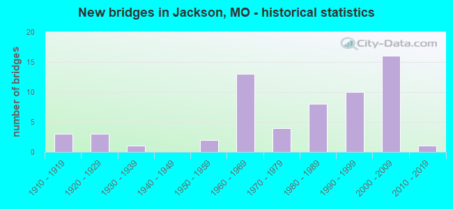
- New bridges - historical statistics
- 31910-1919
- 31920-1929
- 11930-1939
- 21950-1959
- 131960-1969
- 41970-1979
- 81980-1989
- 101990-1999
- 162000-2009
- 12010-2019
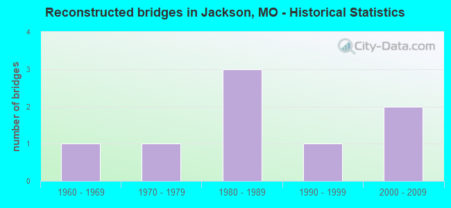
- Reconstructed bridges - Historical Statistics
- 11960-1969
- 11970-1979
- 31980-1989
- 11990-1999
- 22000-2009
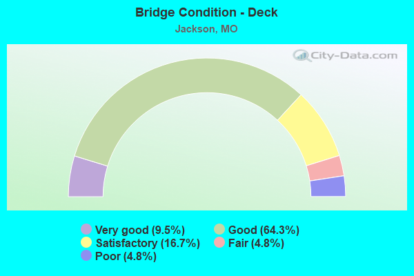
- Bridge Condition - Deck
- 9.5%Very good
- 64.3%Good
- 16.7%Satisfactory
- 4.8%Fair
- 4.8%Poor
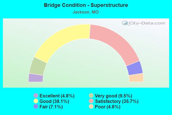
- Bridge Condition - Superstructure
- 4.8%Excellent
- 9.5%Very good
- 38.1%Good
- 35.7%Satisfactory
- 7.1%Fair
- 4.8%Poor
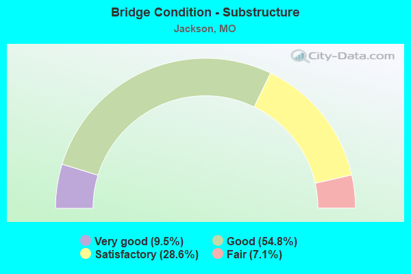
- Bridge Condition - Substructure
- 9.5%Very good
- 54.8%Good
- 28.6%Satisfactory
- 7.1%Fair
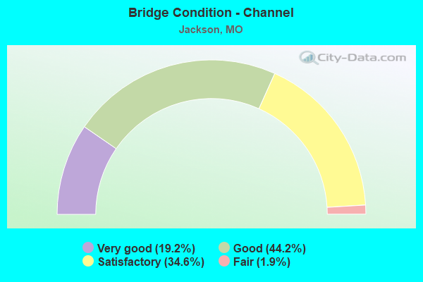
- Bridge Condition - Channel
- 19.2%Very good
- 44.2%Good
- 34.6%Satisfactory
- 1.9%Fair
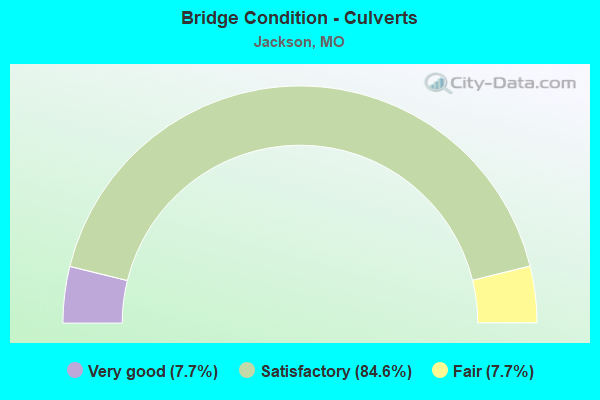
- Bridge Condition - Culverts
- 7.7%Very good
- 84.6%Satisfactory
- 7.7%Fair
Find on map >> Show street view
Structure Number: 34994, Location: S 202 T 31 N R 13 W (Lat: 37.370839, Lng: -89.615594), Route carried "on" structure: City street 69, Year Built: 2015, Status: Open, Structure Length: 1.92m (6.30ft), Average Daily Traffic: 130 (year 2020), Truck Traffic: 10%, Average Future Daily Traffic: 195 (year 2040), Design Load: HS 20+Mod, Features Intersected: WILLIAMS CR, Facility Carried by Structure: S OLD ORCHARD RD
Minimum Vertical Clearance: 30+ m (98+ ft), Kilometerpoint: 1.287, Lanes on structure: 2, Owner: City or Municipal Highway Agency, Approaching Roadway Width: 12.8m (42.0ft), Material/Design: Prestressed concrete, Design/Construction: Slab, Number Of Spans In Main Unit: 1, Length of Maximum Span: 18.4m (60.4ft), Curb or Sidewalk Widths: Left: 1.8m (5.9ft), Right: 1.8m (5.9ft), Curb-To-Curb Width: 11.3m (37.1ft), Out-to-Out Width: 15.8m (51.8ft)
Condition: Deck: Good, Superstructure: Good, Substructure: Good, Channel: Very good, Operating Rating: 65.7 metric tons, Method Used To Determine Operating Rating: Load Factor (LF), Inventory Rating: 39.6 metric tons, Method Used To Determine Inventory Rating: Load Factor (LF), Structural Evaluation: Better than present minimum criteria, Deck Geometry: Superior to present desirable criteria, Waterway Adequacy: Superior to present desirable criteria, Approach Roadway Alignment: Equal to present desirable criteria, Designated Inspection Frequency: Every 24 months, Inspection Date: January 2022, Deck Structure Type: Concrete Cast-file-Place, Wearing Surface/Protective System: Wearing Surface: Monolithic Concrete
Find on map >> Show street view
Structure Number: 35391, Location: S 797 T 31 N R 13 E (Lat: 37.380519, Lng: -89.650000), Route carried "on" structure: City street , Year Built: 1980, Status: Open, Structure Length: 1.03m (3.38ft), Average Daily Traffic: 800 (year 2020), Truck Traffic: 10%, Average Future Daily Traffic: 1,200 (year 2040), Features Intersected: DITCH, Facility Carried by Structure: EAST MAIN ST
Minimum Vertical Clearance: 30+ m (98+ ft), Kilometerpoint: 0.000, Lanes on structure: 2, Owner: City or Municipal Highway Agency, Approaching Roadway Width: 13.7m (44.9ft), Material/Design: Concrete, Design/Construction: Culvert, Number Of Spans In Main Unit: 3, Length of Maximum Span: 3.1m (10.2ft), Curb-To-Curb Width: 10.7m (35.1ft), Out-to-Out Width: 13.7m (44.9ft)
Condition: Channel: Good, Culverts: Satisfactory, Operating Rating: 54.0 metric tons, Method Used To Determine Operating Rating: Load Factor (LF), Inventory Rating: 32.4 metric tons, Method Used To Determine Inventory Rating: Load Factor (LF), Structural Evaluation: Equal to present minimum criteria, Deck Geometry: Equal to present minimum criteria, Waterway Adequacy: Superior to present desirable criteria, Approach Roadway Alignment: Equal to present desirable criteria, Designated Inspection Frequency: Every 24 months, Inspection Date: January 2022, Deck Structure Type: Concrete Cast-file-Place
Find on map >> Show street view
Structure Number: 3588, Location: S 244 T 31 N R 12 E (Lat: 37.370425, Lng: -89.683061), Route carried "on" structure: State highway PP, Year Built: 1985, Status: Open, Structure Length: 0.90m (2.95ft), Average Daily Traffic: 1,509 (year 2021), Truck Traffic: 12%, Average Future Daily Traffic: 2,339 (year 2041), Design Load: HS 20, Features Intersected: ROCKY BR
Minimum Vertical Clearance: 30+ m (98+ ft), Kilometerpoint: 1.184, Lanes on structure: 2, Owner: State Highway Agency, Approaching Roadway Width: 6.7m (22.0ft), Skew: 1 degrees, Material/Design: Concrete continuous, Design/Construction: Culvert, Number Of Spans In Main Unit: 2, Length of Maximum Span: 4.3m (14.1ft)
Condition: Channel: Satisfactory, Culverts: Satisfactory, Inventory Rating: 81.0 metric tons, Method Used To Determine Inventory Rating: Load Factor (LF), Structural Evaluation: Equal to present minimum criteria, Waterway Adequacy: Equal to present desirable criteria, Approach Roadway Alignment: Equal to present desirable criteria, Designated Inspection Frequency: Every 24 months, Inspection Date: Febuary 2022
Find on map >> Show street view
Structure Number: 3727, Location: S 27 T 31 N R 12 E (Lat: 37.376664, Lng: -89.666486), Route carried "on" structure: US 61, Year Built: 1986, Status: Open, Structure Length: 3.60m (11.81ft), Average Daily Traffic: 21,614 (year 2021), Truck Traffic: 6%, Average Future Daily Traffic: 35,663 (year 2041), Design Load: HS 20, Features Intersected: GOOSE CR
Minimum Vertical Clearance: 30+ m (98+ ft), Kilometerpoint: 451.979, Lanes on structure: 4, Base Highway Network: Yes, Owner: State Highway Agency, Approaching Roadway Width: 23.8m (78.1ft), Skew: 2 degrees, Material/Design: Prestressed concrete continuous, Design/Construction: Tee Beam, Number Of Spans In Main Unit: 3, Length of Maximum Span: 12.1m (39.7ft), Curb or Sidewalk Widths: Left: 0.2m (0.7ft), Right: 0.2m (0.7ft), Curb-To-Curb Width: 25.8m (84.6ft), Out-to-Out Width: 26.7m (87.6ft)
Condition: Deck: Satisfactory, Superstructure: Satisfactory, Substructure: Satisfactory, Channel: Satisfactory, Operating Rating: 71.1 metric tons, Method Used To Determine Operating Rating: Load Factor (LF), Inventory Rating: 42.3 metric tons, Method Used To Determine Inventory Rating: Load Factor (LF), Structural Evaluation: Equal to present minimum criteria, Deck Geometry: Superior to present desirable criteria, Waterway Adequacy: Equal to present desirable criteria, Approach Roadway Alignment: Equal to present desirable criteria, Designated Inspection Frequency: Every 24 months, Inspection Date: November 2021, Deck Structure Type: Concrete Cast-file-Place, Wearing Surface/Protective System: Wearing Surface: Monolithic Concrete, Deck Protection: Internally Sealed
Find on map >> Show street view
Structure Number: 3728, Location: S 527 T 31 N R 12 E (Lat: 37.376194, Lng: -89.667092), Route carried "on" structure: State highway 25, Year Built: 1986, Status: Open, Structure Length: 4.24m (13.91ft), Average Daily Traffic: 7,246 (year 2021), Truck Traffic: 23%, Average Future Daily Traffic: 11,956 (year 2041), Design Load: HS 20, Features Intersected: GOOSE CR
Minimum Vertical Clearance: 30+ m (98+ ft), Kilometerpoint: 0.058, Lanes on structure: 4, Owner: State Highway Agency, Approaching Roadway Width: 20.7m (67.9ft), Skew: 2 degrees, Material/Design: Prestressed concrete continuous, Design/Construction: Tee Beam, Number Of Spans In Main Unit: 3, Length of Maximum Span: 14.2m (46.6ft), Curb or Sidewalk Widths: Left: 0.2m (0.7ft), Right: 0.2m (0.7ft), Curb-To-Curb Width: 22.8m (74.8ft), Out-to-Out Width: 23.6m (77.4ft)
Condition: Deck: Good, Superstructure: Satisfactory, Substructure: Very good, Channel: Good, Operating Rating: 40.5 metric tons, Method Used To Determine Operating Rating: Load Factor (LF), Inventory Rating: 24.3 metric tons, Method Used To Determine Inventory Rating: Load Factor (LF), Structural Evaluation: Equal to present minimum criteria, Deck Geometry: Superior to present desirable criteria, Waterway Adequacy: Equal to present desirable criteria, Approach Roadway Alignment: Equal to present desirable criteria, Designated Inspection Frequency: Every 24 months, Inspection Date: November 2021, Deck Structure Type: Concrete Cast-file-Place, Wearing Surface/Protective System: Wearing Surface: Monolithic Concrete, Deck Protection: Internally Sealed
Find on map >> Show street view
Structure Number: 3744, Location: S 235 T 31 N R 13 E (Lat: 37.361842, Lng: -89.628536), Route carried "on" structure: US 61, Year Built: 1989, Status: Open, Structure Length: 3.78m (12.40ft), Average Daily Traffic: 23,221 (year 2021), Truck Traffic: 7%, Average Future Daily Traffic: 38,315 (year 2041), Design Load: HS 20, Features Intersected: WILLIAMS CR
Minimum Vertical Clearance: 30+ m (98+ ft), Kilometerpoint: 455.759, Lanes on structure: 4, Base Highway Network: Yes, Owner: State Highway Agency, Approaching Roadway Width: 18.3m (60.0ft), Material/Design: Prestressed concrete continuous, Design/Construction: Tee Beam, Number Of Spans In Main Unit: 3, Length of Maximum Span: 12.6m (41.3ft), Curb or Sidewalk Widths: Left: 0.2m (0.7ft), Right: 0.2m (0.7ft), Curb-To-Curb Width: 22.2m (72.8ft), Out-to-Out Width: 23.0m (75.5ft)
Condition: Deck: Satisfactory, Superstructure: Satisfactory, Substructure: Very good, Channel: Good, Operating Rating: 61.2 metric tons, Method Used To Determine Operating Rating: Load Factor (LF), Inventory Rating: 36.9 metric tons, Method Used To Determine Inventory Rating: Load Factor (LF), Structural Evaluation: Equal to present minimum criteria, Deck Geometry: Superior to present desirable criteria, Waterway Adequacy: Equal to present desirable criteria, Approach Roadway Alignment: Equal to present desirable criteria, Designated Inspection Frequency: Every 24 months, Inspection Date: November 2021, Deck Structure Type: Concrete Cast-file-Place, Wearing Surface/Protective System: Wearing Surface: Monolithic Concrete, Deck Protection: Internally Sealed
Find on map >> Show street view
Structure Number: 381, Location: S 2192 T 32 N R 13 E (Lat: 37.427719, Lng: -89.639953), Route carried "on" structure: Ramp State highway , Year Built: 1969, Year Reconstructed: 1999, Status: Open, Structure Length: 0.63m (2.07ft), Average Daily Traffic: 6,048 (year 2021), Truck Traffic: 18%, Average Future Daily Traffic: 11,794 (year 2041), Design Load: H 20, Features Intersected: HUBBLE CR, Facility Carried by Structure: RP US61 TO IS55S S
Minimum Vertical Clearance: 30+ m (98+ ft), Kilometerpoint: 0.074, Lanes on structure: 1, Base Highway Network: Yes, Owner: State Highway Agency, Approaching Roadway Width: 10.1m (33.1ft), Material/Design: Concrete continuous, Design/Construction: Culvert, Number Of Spans In Main Unit: 2, Length of Maximum Span: 3.0m (9.8ft)
Condition: Channel: Satisfactory, Culverts: Satisfactory, Operating Rating: 93.6 metric tons, Method Used To Determine Operating Rating: Load Factor (LF), Inventory Rating: 55.8 metric tons, Method Used To Determine Inventory Rating: Load Factor (LF), Structural Evaluation: Equal to present minimum criteria, Waterway Adequacy: Equal to present desirable criteria, Approach Roadway Alignment: Equal to present desirable criteria, Designated Inspection Frequency: Every 24 months, Inspection Date: Febuary 2022
Find on map >> Show street view
Structure Number: 3924, Location: S 2196 T 31 N R 12 E (Lat: 37.387503, Lng: -89.720931), Route carried "on" structure: State highway 72, Year Built: 1990, Year Reconstructed: 2008, Status: Open, Structure Length: 5.43m (17.81ft), Average Daily Traffic: 12,464 (year 2021), Truck Traffic: 7%, Average Future Daily Traffic: 24,305 (year 2041), Design Load: HS 20, Features Intersected: CANE CR
Minimum Vertical Clearance: 30+ m (98+ ft), Kilometerpoint: 261.609, Lanes on structure: 4, Base Highway Network: Yes, Owner: State Highway Agency, Approaching Roadway Width: 14.6m (47.9ft), Skew: 2 degrees, Material/Design: Prestressed concrete continuous, Design/Construction: Stringer/Multi-beam, Number Of Spans In Main Unit: 3, Length of Maximum Span: 18.2m (59.7ft), Curb-To-Curb Width: 18.5m (60.7ft), Out-to-Out Width: 19.1m (62.7ft)
Condition: Deck: Satisfactory, Superstructure: Good, Substructure: Good, Channel: Satisfactory, Operating Rating: 61.2 metric tons, Method Used To Determine Operating Rating: Load Factor (LF), Inventory Rating: 36.9 metric tons, Method Used To Determine Inventory Rating: Load Factor (LF), Structural Evaluation: Better than present minimum criteria, Deck Geometry: Equal to present minimum criteria, Waterway Adequacy: Equal to present desirable criteria, Approach Roadway Alignment: Equal to present desirable criteria, Designated Inspection Frequency: Every 24 months, Inspection Date: November 2021, Deck Structure Type: Concrete Cast-file-Place, Wearing Surface/Protective System: Wearing Surface: Monolithic Concrete, Deck Protection: Internally Sealed
Find on map >> Show street view
Structure Number: 4139, Location: S 16 T 49 N R 33 W (Lat: 39.062894, Lng: -94.560744), Route carried "on" structure: City street , Year Built: 1995, Status: Open, Structure Length: 5.79m (19.00ft), Average Daily Traffic: 5,027 (year 2021), Truck Traffic: 5%, Average Future Daily Traffic: 6,786 (year 2041), Design Load: HS 20+Mod, Features Intersected: US 71, Facility Carried by Structure: E 35TH ST E
Minimum Vertical Clearance: 30+ m (98+ ft), Kilometerpoint: 0.507, Lanes on structure: 2, Lanes under structure: 8, Owner: State Highway Agency, Approaching Roadway Width: 14.0m (45.9ft), Material/Design: Steel continuous, Design/Construction: Stringer/Multi-beam, Number Of Spans In Main Unit: 2, Length of Maximum Span: 34.1m (111.9ft), Curb or Sidewalk Widths: Left: 0.2m (0.7ft), Right: 0.2m (0.7ft), Curb-To-Curb Width: 12.2m (40.0ft), Out-to-Out Width: 14.0m (45.9ft)
Condition: Deck: Good, Superstructure: Very good, Substructure: Very good, Operating Rating: 59.4 metric tons, Method Used To Determine Operating Rating: Load Factor (LF), Inventory Rating: 36.0 metric tons, Method Used To Determine Inventory Rating: Load Factor (LF), Structural Evaluation: Equal to present desirable criteria, Deck Geometry: Somewhat better than minimum adequacy, Underclear: Somewhat better than minimum adequacy, Approach Roadway Alignment: Better than present minimum criteria, Designated Inspection Frequency: Every 24 months, Inspection Date: September 2021, Deck Structure Type: Concrete Cast-file-Place, Wearing Surface/Protective System: Wearing Surface: Monolithic Concrete, Deck Protection: Epoxy Coated Reinforcing
Find on map >> Show street view
Structure Number: 501, Location: S 799 T 32 N R 13 E (Lat: 37.413164, Lng: -89.632219), Route carried "on" structure: State highway Y, Year Built: 1961, Year Reconstructed: 2013, Status: Open, Structure Length: 9.14m (29.99ft), Average Daily Traffic: 1,758 (year 2021), Truck Traffic: 7%, Average Future Daily Traffic: 2,725 (year 2041), Design Load: H 15, Features Intersected: IS 55
Minimum Vertical Clearance: 30+ m (98+ ft), Kilometerpoint: 1.711, Lanes on structure: 2, Lanes under structure: 4, Owner: State Highway Agency, Approaching Roadway Width: 6.1m (20.0ft), Skew: 3 degrees, Material/Design: Steel continuous, Design/Construction: Stringer/Multi-beam, Number Of Spans In Main Unit: 4, Length of Maximum Span: 24.4m (80.1ft), Curb-To-Curb Width: 7.9m (25.9ft), Out-to-Out Width: 8.7m (28.5ft)
Condition: Deck: Very good, Superstructure: Very good, Substructure: Good, Operating Rating: 44.1 metric tons, Method Used To Determine Operating Rating: Load Factor (LF), Inventory Rating: 26.1 metric tons, Method Used To Determine Inventory Rating: Load Factor (LF), Structural Evaluation: Equal to present minimum criteria, Deck Geometry: Meets minimum limits, Underclear: Equal to present minimum criteria, Approach Roadway Alignment: Equal to present desirable criteria, Designated Inspection Frequency: Every 24 months, Inspection Date: November 2021, Deck Structure Type: Concrete Cast-file-Place, Wearing Surface/Protective System: Wearing Surface: Other, Deck Protection: Epoxy Coated Reinforcing
Find on map >> Show street view
Structure Number: 5198, Location: S 1 T 31 N R 12 E (Lat: 37.390122, Lng: -89.666667), Route carried "on" structure: US 61, Year Built: 1925, Year Reconstructed: 1971, Status: Open, Structure Length: 3.90m (12.80ft), Average Daily Traffic: 7,072 (year 2021), Truck Traffic: 6%, Average Future Daily Traffic: 11,669 (year 2041), Design Load: H 15, Features Intersected: HUBBLE CR
Minimum Vertical Clearance: 30+ m (98+ ft), Kilometerpoint: 450.305, Lanes on structure: 2, Owner: State Highway Agency, Approaching Roadway Width: 6.1m (20.0ft), Skew: 3 degrees, Material/Design: Concrete, Design/Construction: Tee Beam, Number Of Spans In Main Unit: 3, Length of Maximum Span: 13.0m (42.7ft), Curb-To-Curb Width: 6.9m (22.6ft), Out-to-Out Width: 7.1m (23.3ft)
Condition: Deck: Poor, Superstructure: Poor, Substructure: Fair, Channel: Satisfactory, Operating Rating: 42.3 metric tons, Method Used To Determine Operating Rating: Load Factor (LF), Inventory Rating: 25.2 metric tons, Method Used To Determine Inventory Rating: Load Factor (LF), Structural Evaluation: Meets minimum limits, Deck Geometry: High priority of replacement, Waterway Adequacy: Equal to present desirable criteria, Approach Roadway Alignment: Equal to present desirable criteria, Length Of Structure Improvement: 0.48m (1.57ft), Designated Inspection Frequency: Every 24 months, Inspection Date: November 2021, Bridge Improvement Cost: $603,000, Roadway Improvement Cost: $60,000, Total Project Cost: $904,000 ( Estimate for 2022), Deck Structure Type: Concrete Cast-file-Place, Wearing Surface/Protective System: Wearing Surface: Bituminous, Membrane: Built-up
Find on map >> Show street view
Structure Number: 7837, Location: S 796 T 32 N R 12 E (Lat: 37.420147, Lng: -89.714703), Route carried "on" structure: State highway D, Year Built: 1954, Status: Open, Structure Length: 0.76m (2.49ft), Average Daily Traffic: 825 (year 2021), Truck Traffic: 11%, Average Future Daily Traffic: 1,279 (year 2041), Design Load: H 10, Features Intersected: COOPER CR
Minimum Vertical Clearance: 30+ m (98+ ft), Kilometerpoint: 20.020, Lanes on structure: 2, Owner: State Highway Agency, Approaching Roadway Width: 7.3m (24.0ft), Material/Design: Concrete continuous, Design/Construction: Culvert, Number Of Spans In Main Unit: 2, Length of Maximum Span: 3.7m (12.1ft), Curb-To-Curb Width: 9.4m (30.8ft), Out-to-Out Width: 10.1m (33.1ft)
Condition: Channel: Satisfactory, Culverts: Satisfactory, Operating Rating: 44.1 metric tons, Method Used To Determine Operating Rating: Load Factor (LF), Inventory Rating: 26.1 metric tons, Method Used To Determine Inventory Rating: Load Factor (LF), Structural Evaluation: Equal to present minimum criteria, Deck Geometry: Equal to present minimum criteria, Waterway Adequacy: Equal to present minimum criteria, Approach Roadway Alignment: Equal to present minimum criteria, Designated Inspection Frequency: Every 24 months, Inspection Date: Febuary 2022
Find on map >> Show street view
Structure Number: 7838, Location: S 229 T 32 N R 12 E (Lat: 37.412842, Lng: -89.701492), Route carried "on" structure: State highway D, Year Built: 1954, Status: Posted for load, Structure Length: 2.99m (9.81ft), Average Daily Traffic: 825 (year 2021), Truck Traffic: 11%, Average Future Daily Traffic: 1,279 (year 2041), Design Load: H 10, Features Intersected: CANE CR
Minimum Vertical Clearance: 30+ m (98+ ft), Kilometerpoint: 21.482, Lanes on structure: 2, Owner: State Highway Agency, Approaching Roadway Width: 6.1m (20.0ft), Skew: 3 degrees, Material/Design: Concrete, Design/Construction: Tee Beam, Number Of Spans In Main Unit: 3, Length of Maximum Span: 9.9m (32.5ft), Curb-To-Curb Width: 6.1m (20.0ft), Out-to-Out Width: 7.1m (23.3ft)
Condition: Deck: Poor, Superstructure: Fair, Substructure: Fair, Channel: Satisfactory, Operating Rating: 25.2 metric tons, Method Used To Determine Operating Rating: Load Factor (LF), Inventory Rating: 15.3 metric tons, Method Used To Determine Inventory Rating: Load Factor (LF), Structural Evaluation: Meets minimum limits, Deck Geometry: High priority of corrective action, Waterway Adequacy: Equal to present desirable criteria, Approach Roadway Alignment: Meets minimum limits, Bridge Posting: Required (Relationship of Operating Rating to Maximum Legal Load: 20.0 - 29.9% below), Length Of Structure Improvement: 0.39m (1.28ft), Designated Inspection Frequency: Every 24 months, Inspection Date: November 2021, Bridge Improvement Cost: $445,000, Roadway Improvement Cost: $45,000, Total Project Cost: $668,000 ( Estimate for 2022), Deck Structure Type: Concrete Cast-file-Place, Wearing Surface/Protective System: Wearing Surface: Bituminous, Membrane: Built-up
Find on map >> Show street view
Structure Number: 11961, Location: S 2192 T 32 N R 13 E (Lat: 37.428822, Lng: -89.639500), Route carried "under" structure: US 61, Year Built: 2000, Structure Length: 0. m, Average Daily Traffic: 10,509 (year 2021), Truck Traffic: 8%, Features Intersected: US 61, Facility Carried by Structure: IS 55 N
Minimum Vertical Clearance: 5.03m (16.50ft), Kilometerpoint: 445.273, Lanes on structure: 2, Lanes under structure: 2, Material/Design: Steel continuous, Design/Construction: Stringer/Multi-beam, Length of Maximum Span: 35.4m (116.1ft)
Find on map >> Show street view
Structure Number: 11962, Location: S 2192 T 32 N R 13 E (Lat: 37.428617, Lng: -89.639694), Route carried "under" structure: US 61, Year Built: 2000, Structure Length: 0. m, Average Daily Traffic: 10,509 (year 2021), Truck Traffic: 8%, Features Intersected: US 61, Facility Carried by Structure: IS 55 S
Minimum Vertical Clearance: 5.13m (16.83ft), Kilometerpoint: 445.298, Lanes on structure: 2, Lanes under structure: 2, Material/Design: Steel continuous, Design/Construction: Stringer/Multi-beam, Length of Maximum Span: 35.4m (116.1ft)
Find on map >> Show street view
Structure Number: 2155, Location: S 18 T 32 N R 13 E (Lat: 37.448433, Lng: -89.649014), Route carried "under" structure: Interstate 55, Year Built: 1969, Structure Length: 0. m, Average Daily Traffic: 9,624 (year 2021), Truck Traffic: 22%, Features Intersected: IS 55, Facility Carried by Structure: RT FF E
Minimum Vertical Clearance: 5.18m (16.99ft), Kilometerpoint: 165.182, Lanes on structure: 2, Lanes under structure: 2, Material/Design: Steel continuous, Design/Construction: Stringer/Multi-beam, Length of Maximum Span: 28.9m (94.8ft)
Find on map >> Show street view
Structure Number: 2155, Location: S 18 T 32 N R 13 E (Lat: 37.448433, Lng: -89.649014), Route carried "under" structure: Interstate 55, Year Built: 1969, Structure Length: 0. m, Average Daily Traffic: 9,427 (year 2021), Truck Traffic: 22%, Features Intersected: IS 55, Facility Carried by Structure: RT FF E
Minimum Vertical Clearance: 5.13m (16.83ft), Kilometerpoint: 172.528, Lanes on structure: 2, Lanes under structure: 2, Material/Design: Steel continuous, Design/Construction: Stringer/Multi-beam, Length of Maximum Span: 28.9m (94.8ft)
Find on map >> Show street view
Structure Number: 501, Location: S 799 T 32 N R 13 E (Lat: 37.413164, Lng: -89.632219), Route carried "under" structure: Interstate 55, Year Built: 1961, Structure Length: 0. m, Average Daily Traffic: 10,592 (year 2021), Truck Traffic: 22%, Features Intersected: IS 55, Facility Carried by Structure: RT Y E
Minimum Vertical Clearance: 6.10m (20.01ft), Kilometerpoint: 169.371, Lanes on structure: 2, Lanes under structure: 2, Material/Design: Steel continuous, Design/Construction: Stringer/Multi-beam, Length of Maximum Span: 24.4m (80.1ft)
Find on map >> Show street view
Structure Number: 501, Location: S 799 T 32 N R 13 E (Lat: 37.413164, Lng: -89.632219), Route carried "under" structure: Interstate 55, Year Built: 1961, Structure Length: 0. m, Average Daily Traffic: 11,448 (year 2021), Truck Traffic: 22%, Features Intersected: IS 55, Facility Carried by Structure: RT Y E
Minimum Vertical Clearance: 6.10m (20.01ft), Kilometerpoint: 168.339, Lanes on structure: 2, Lanes under structure: 2, Material/Design: Steel continuous, Design/Construction: Stringer/Multi-beam, Length of Maximum Span: 24.4m (80.1ft)