Bridge Statistics for Jacksonville, Arkansas (AR)
Condition, Traffic, Stress, Structural Evaluation, Project Costs
- National Bridge Inventory (NBI) Statistics
- 69Number of bridges
- 1,742ft / 531mTotal length
- $4,186,000Total costs
- 1,265,466Total average daily traffic
- 100,346Total average daily truck traffic
- National Bridge Inventory (NBI) Registered Bridges for Jacksonville
- No street view available for this location
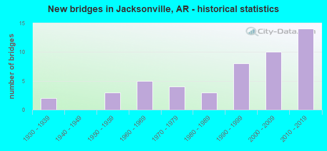
- New bridges - historical statistics
- 21930-1939
- 31950-1959
- 51960-1969
- 41970-1979
- 31980-1989
- 81990-1999
- 102000-2009
- 142010-2019
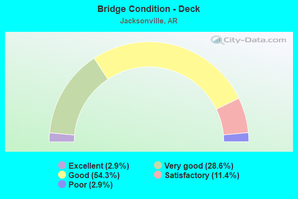
- Bridge Condition - Deck
- 2.9%Excellent
- 28.6%Very good
- 54.3%Good
- 11.4%Satisfactory
- 2.9%Poor
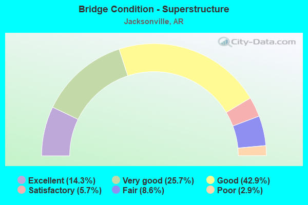
- Bridge Condition - Superstructure
- 14.3%Excellent
- 25.7%Very good
- 42.9%Good
- 5.7%Satisfactory
- 8.6%Fair
- 2.9%Poor
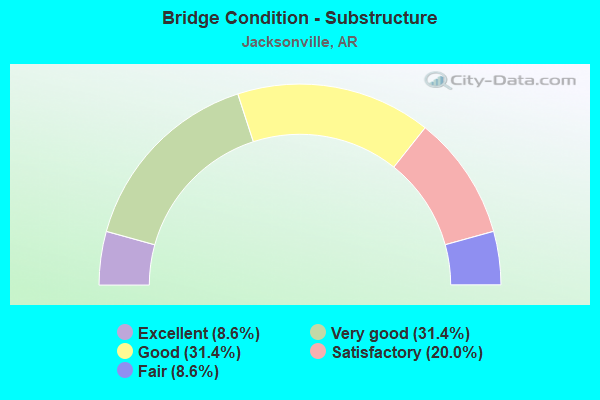
- Bridge Condition - Substructure
- 8.6%Excellent
- 31.4%Very good
- 31.4%Good
- 20.0%Satisfactory
- 8.6%Fair
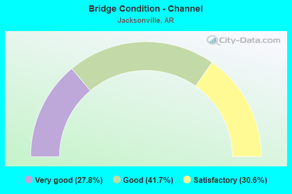
- Bridge Condition - Channel
- 27.8%Very good
- 41.7%Good
- 30.6%Satisfactory
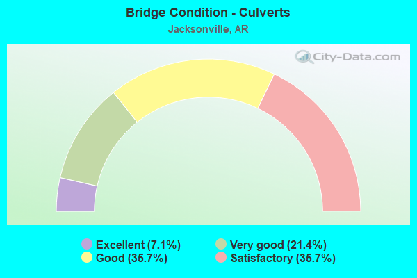
- Bridge Condition - Culverts
- 7.1%Excellent
- 21.4%Very good
- 35.7%Good
- 35.7%Satisfactory
Find on map >> Show street view
Structure Number: B7283, Location: 9.07 Mi N of I-40 (Lat: 34.867161, Lng: -92.127814), Route carried "on" structure: US 67, Year Built: 2017, Status: Open, Structure Length: 7.32m (24.02ft), Average Daily Traffic: 67,769 (year 2018), Truck Traffic: 8%, Average Future Daily Traffic: 80,282 (year 2036), Design Load: HL 93, Features Intersected: Main St.
Minimum Vertical Clearance: 30.17m (98.98ft), Kilometerpoint: 14.597, Lanes on structure: 3, Lanes under structure: 7, Base Highway Network: Yes, Owner: State Highway Agency, Approaching Roadway Width: 17.1m (56.1ft), Skew: 2 degrees, Material/Design: Steel continuous, Design/Construction: Stringer/Multi-beam, Number Of Spans In Main Unit: 3, Length of Maximum Span: 31.4m (103.0ft), Curb-To-Curb Width: 17.1m (56.1ft), Out-to-Out Width: 18.0m (59.1ft)
Condition: Deck: Very good, Superstructure: Excellent, Substructure: Excellent, Operating Rating: 54.4 metric tons, Method Used To Determine Operating Rating: Load and Resistance Factor (LRFR), Inventory Rating: 32.7 metric tons, Method Used To Determine Inventory Rating: Load and Resistance Factor (LRFR), Structural Evaluation: Superior to present desirable criteria, Deck Geometry: Equal to present minimum criteria, Underclear: High priority of corrective action, Approach Roadway Alignment: Equal to present desirable criteria, Designated Inspection Frequency: Every 24 months, Critical Feature Inspection Frequency: Every 24 months, Inspection Date: May 2020, Deck Structure Type: Concrete Cast-file-Place, Wearing Surface/Protective System: Deck Protection: Epoxy Coated Reinforcing
Find on map >> Show street view
Structure Number: M1235, Location: .5 MI S REDMOND RD EXIT (Lat: 34.855608, Lng: -92.135539), Route carried "on" structure: US 67, Year Built: 1960, Status: Open, Structure Length: 0.64m (2.10ft), Average Daily Traffic: 75,000 (year 2018), Truck Traffic: 6%, Average Future Daily Traffic: 101,000 (year 2033), Features Intersected: Rocky Branch
Minimum Vertical Clearance: 30+ m (98+ ft), Kilometerpoint: 13.049, Lanes on structure: 7, Base Highway Network: Yes, Owner: State Highway Agency, Approaching Roadway Width: 19.5m (64.0ft), Material/Design: Concrete, Design/Construction: Culvert, Number Of Spans In Main Unit: 2, Length of Maximum Span: 3.0m (9.8ft)
Condition: Channel: Satisfactory, Culverts: Satisfactory, Operating Rating: 29.9 metric tons, Method Used To Determine Operating Rating: Load Factor (LF), Inventory Rating: 18.1 metric tons, Method Used To Determine Inventory Rating: Load Factor (LF), Structural Evaluation: Meets minimum limits, Waterway Adequacy: Better than present minimum criteria, Approach Roadway Alignment: Equal to present desirable criteria, Designated Inspection Frequency: Every 24 months, Critical Feature Inspection Frequency: Every 24 months, Inspection Date: April 2021
Find on map >> Show street view
Structure Number: M1236, Location: .25 MILES SO OF REDMOND R (Lat: 34.857419, Lng: -92.132878), Route carried "on" structure: US 67, Year Built: 1960, Status: Open, Structure Length: 0.98m (3.22ft), Average Daily Traffic: 75,000 (year 2018), Truck Traffic: 6%, Average Future Daily Traffic: 101,000 (year 2033), Features Intersected: BRANCH
Minimum Vertical Clearance: 30+ m (98+ ft), Kilometerpoint: 13.354, Lanes on structure: 8, Base Highway Network: Yes, Owner: State Highway Agency, Approaching Roadway Width: 19.5m (64.0ft), Material/Design: Concrete, Design/Construction: Culvert, Number Of Spans In Main Unit: 3, Length of Maximum Span: 3.0m (9.8ft)
Condition: Channel: Good, Culverts: Satisfactory, Operating Rating: 35.4 metric tons, Method Used To Determine Operating Rating: Load Factor (LF), Inventory Rating: 21.8 metric tons, Method Used To Determine Inventory Rating: Load Factor (LF), Structural Evaluation: Somewhat better than minimum adequacy, Waterway Adequacy: Better than present minimum criteria, Approach Roadway Alignment: Equal to present desirable criteria, Designated Inspection Frequency: Every 24 months, Critical Feature Inspection Frequency: Every 24 months, Inspection Date: April 2021
Find on map >> Show street view
Structure Number: M1237, Location: 1.7 MI N OF MAIN ST JACKS (Lat: 34.884925, Lng: -92.108992), Route carried "on" structure: US 67, Year Built: 1960, Status: Open, Structure Length: 0.79m (2.59ft), Average Daily Traffic: 53,118 (year 2018), Truck Traffic: 13%, Average Future Daily Traffic: 74,000 (year 2033), Features Intersected: CREEK
Minimum Vertical Clearance: 30+ m (98+ ft), Kilometerpoint: 17.231, Lanes on structure: 10, Base Highway Network: Yes, Owner: State Highway Agency, Approaching Roadway Width: 30.2m (99.1ft), Skew: 33 degrees, Material/Design: Concrete, Design/Construction: Culvert, Number Of Spans In Main Unit: 2, Length of Maximum Span: 4.0m (13.1ft)
Condition: Channel: Very good, Culverts: Good, Operating Rating: 41.7 metric tons, Method Used To Determine Operating Rating: Load Factor (LF), Inventory Rating: 25.4 metric tons, Method Used To Determine Inventory Rating: Load Factor (LF), Structural Evaluation: Equal to present minimum criteria, Waterway Adequacy: Equal to present desirable criteria, Approach Roadway Alignment: Equal to present desirable criteria, Designated Inspection Frequency: Every 24 months, Critical Feature Inspection Frequency: Every 24 months, Inspection Date: March 2020
Find on map >> Show street view
Structure Number: X0796, Location: 2 MI WEST US 67 (Lat: 34.871417, Lng: -92.158806), Route carried "on" structure: City street 28880, Year Built: 1991, Status: Open, Structure Length: 0.79m (2.59ft), Average Daily Traffic: 6,800 (year 2018), Truck Traffic: 1%, Average Future Daily Traffic: 648 (year 2010), Design Load: H 20, Features Intersected: CREEK, Facility Carried by Structure: JacksonvilleCutoff
Minimum Vertical Clearance: 30+ m (98+ ft), Kilometerpoint: 0.129, Lanes on structure: 2, Owner: City or Municipal Highway Agency, Approaching Roadway Width: 14.0m (45.9ft), Material/Design: Concrete, Design/Construction: Culvert, Number Of Spans In Main Unit: 2, Length of Maximum Span: 3.7m (12.1ft)
Condition: Channel: Satisfactory, Culverts: Good, Operating Rating: 31.8 metric tons, Method Used To Determine Operating Rating: Load Factor (LF), Inventory Rating: 19.1 metric tons, Method Used To Determine Inventory Rating: Load Factor (LF), Structural Evaluation: Meets minimum limits, Waterway Adequacy: Equal to present desirable criteria, Approach Roadway Alignment: Equal to present desirable criteria, Designated Inspection Frequency: Every 24 months, Critical Feature Inspection Frequency: Every 24 months, Inspection Date: July 2020
Find on map >> Show street view
Structure Number: X1517, Location: 1.0 ML S of SH 5 (Lat: 34.941800, Lng: -92.072778), Route carried "on" structure: US 67, Year Built: 2018, Status: Open, Structure Length: 1.43m (4.69ft), Average Daily Traffic: 56,135 (year 2016), Truck Traffic: 10%, Average Future Daily Traffic: 80,500 (year 2036), Design Load: HL 93, Features Intersected: Glade Branch
Minimum Vertical Clearance: 30.44m (99.87ft), Kilometerpoint: 0.032, Lanes on structure: 10, Base Highway Network: Yes (Inventory Route: 671, Subroute: 1), Owner: State Highway Agency, Approaching Roadway Width: 11.0m (36.1ft), Material/Design: Concrete, Design/Construction: Culvert, Number Of Spans In Main Unit: 5, Length of Maximum Span: 2.4m (7.9ft)
Condition: Channel: Very good, Culverts: Very good, Operating Rating: 54.4 metric tons, Method Used To Determine Operating Rating: Load and Resistance Factor (LRFR), Inventory Rating: 32.7 metric tons, Method Used To Determine Inventory Rating: Load and Resistance Factor (LRFR), Structural Evaluation: Equal to present desirable criteria, Waterway Adequacy: Equal to present desirable criteria, Approach Roadway Alignment: Equal to present desirable criteria, Designated Inspection Frequency: Every 24 months, Critical Feature Inspection Frequency: Every 24 months, Inspection Date: Febuary 2021
Find on map >> Show street view
Structure Number: X1518, Location: 4 miles south of SH 5 (Lat: 34.897769, Lng: -92.091428), Route carried "on" structure: US 67, Year Built: 2018, Status: Open, Structure Length: 0.66m (2.17ft), Average Daily Traffic: 53,466 (year 2016), Truck Traffic: 10%, Average Future Daily Traffic: 61,000 (year 2038), Design Load: HL 93, Features Intersected: Branch Jacks Bayou
Minimum Vertical Clearance: 30+ m (98+ ft), Kilometerpoint: 19.328, Lanes on structure: 10, Base Highway Network: Yes (Inventory Route: 671, Subroute: 67), Owner: State Highway Agency, Approaching Roadway Width: 17.4m (57.1ft), Skew: 30 degrees, Material/Design: Concrete, Design/Construction: Culvert, Number Of Spans In Main Unit: 3, Length of Maximum Span: 1.8m (5.9ft)
Condition: Channel: Very good, Culverts: Excellent, Operating Rating: 35.4 metric tons, Method Used To Determine Operating Rating: Load and Resistance Factor (LRFR), Inventory Rating: 27.2 metric tons, Method Used To Determine Inventory Rating: Load and Resistance Factor (LRFR), Structural Evaluation: Equal to present minimum criteria, Waterway Adequacy: Better than present minimum criteria, Approach Roadway Alignment: Equal to present desirable criteria, Designated Inspection Frequency: Every 24 months, Critical Feature Inspection Frequency: Every 24 months, Inspection Date: November 2020
Find on map >> Show street view
Structure Number: X1519, Location: 3.3 miles south of SH 5 (Lat: 34.906300, Lng: -92.085400), Route carried "on" structure: US 67, Year Built: 2018, Status: Open, Structure Length: 2.41m (7.91ft), Average Daily Traffic: 2,800 (year 2018), Truck Traffic: 10%, Average Future Daily Traffic: 80,500 (year 2036), Design Load: HL 93, Features Intersected: Snake Creek
Minimum Vertical Clearance: 30+ m (98+ ft), Kilometerpoint: 20.471, Lanes on structure: 10, Base Highway Network: Yes (Inventory Route: 671, Subroute: 67), Owner: State Highway Agency, Approaching Roadway Width: 17.5m (57.4ft), Skew: 33 degrees, Material/Design: Concrete, Design/Construction: Culvert, Number Of Spans In Main Unit: 6, Length of Maximum Span: 3.5m (11.5ft)
Condition: Channel: Very good, Culverts: Very good, Operating Rating: 54.4 metric tons, Method Used To Determine Operating Rating: Load and Resistance Factor (LRFR), Inventory Rating: 32.7 metric tons, Method Used To Determine Inventory Rating: Load and Resistance Factor (LRFR), Structural Evaluation: Equal to present desirable criteria, Waterway Adequacy: Better than present minimum criteria, Approach Roadway Alignment: Equal to present desirable criteria, Designated Inspection Frequency: Every 24 months, Critical Feature Inspection Frequency: Every 24 months, Inspection Date: November 2020
Find on map >> Show street view
Structure Number: 3079, Location: .80 MI N MAIN ST JACKSONV (Lat: 34.874989, Lng: -92.118369), Route carried "under" structure: US 67, Structure Length: 0. m, Average Daily Traffic: 27,000 (year 2014), Truck Traffic: 13%, Features Intersected: US 67-SEC 10 LOG 9.81, Facility Carried by Structure: JAMES STREET
Minimum Vertical Clearance: 4.78m (15.68ft), Kilometerpoint: 15.784, Length of Maximum Span: 0.0m
Find on map >> Show street view
Structure Number: 3079, Location: .80 MI N MAIN ST JACKSONV (Lat: 34.874989, Lng: -92.118369), Route carried "under" structure: US 67, Structure Length: 0. m, Average Daily Traffic: 27,000 (year 2014), Truck Traffic: 13%, Features Intersected: US 67-SEC 10 LOG 9.81, Facility Carried by Structure: JAMES STREET
Minimum Vertical Clearance: 4.69m (15.39ft), Kilometerpoint: 15.784, Length of Maximum Span: 0.0m
Find on map >> Show street view
Structure Number: 308, Location: LRAF BASE EXIT (Lat: 34.887139, Lng: -92.107061), Route carried "under" structure: State highway 161, Structure Length: 0. m, Average Daily Traffic: 14,000 (year 2014), Truck Traffic: 1%, Features Intersected: SH 161, Facility Carried by Structure: US 67 SB Log 10.89
Minimum Vertical Clearance: 4.45m (14.60ft), Kilometerpoint: 0.080, Length of Maximum Span: 0.0m
Find on map >> Show street view
Structure Number: 6752, Location: 0.5 Mi E of SH 67 (Lat: 34.866036, Lng: -92.110717), Route carried "under" structure: State highway 161, Structure Length: 0. m, Average Daily Traffic: 9,200 (year 2014), Truck Traffic: 1%, Features Intersected: SH 161, UPRR, Spring St, Facility Carried by Structure: Main Jacksonville
Minimum Vertical Clearance: 4.45m (14.60ft), Kilometerpoint: 2.478, Length of Maximum Span: 0.0m
Find on map >> Show street view
Structure Number: 6752, Location: 0.5 Mi E of SH 67 (Lat: 34.866036, Lng: -92.110717), Route carried "under" structure: City street 54770, Structure Length: 0. m, Average Daily Traffic: 1,000 (year 1987), Truck Traffic: 1%, Features Intersected: SH 161, UPRR, Spring St, Facility Carried by Structure: Main Jacksonville
Minimum Vertical Clearance: 6.03m (19.78ft), Kilometerpoint: 0.805, Length of Maximum Span: 0.0m
Find on map >> Show street view
Structure Number: 6792, Location: SH440 & US 67 (Lat: 34.841439, Lng: -92.152011), Route carried "under" structure: US 67, Structure Length: 0. m, Average Daily Traffic: 41,000 (year 2014), Truck Traffic: 1%, Features Intersected: US 67 LOG 6.82, Facility Carried by Structure: SH 440 SW Ramp
Minimum Vertical Clearance: 5.76m (18.90ft), Kilometerpoint: 10.976, Length of Maximum Span: 0.0m
Find on map >> Show street view
Structure Number: 6792, Location: SH440 & US 67 (Lat: 34.841439, Lng: -92.152011), Route carried "under" structure: US 67, Structure Length: 0. m, Average Daily Traffic: 41,000 (year 2014), Truck Traffic: 1%, Features Intersected: US 67 LOG 6.82, Facility Carried by Structure: SH 440 SW Ramp
Minimum Vertical Clearance: 5.91m (19.39ft), Kilometerpoint: 10.976, Length of Maximum Span: 0.0m
Find on map >> Show street view
Structure Number: 6793, Location: JCT SH 440 & US 67 (I-8) (Lat: 34.837919, Lng: -92.153881), Route carried "under" structure: US 67, Structure Length: 0. m, Average Daily Traffic: 34,000 (year 2014), Truck Traffic: 16%, Features Intersected: US 67 LOG 6.46, Facility Carried by Structure: SH 440 ES ramp
Minimum Vertical Clearance: 7.43m (24.38ft), Kilometerpoint: 10.396, Length of Maximum Span: 0.0m
Find on map >> Show street view
Structure Number: 6793, Location: JCT SH 440 & US 67 (I-8) (Lat: 34.837919, Lng: -92.153881), Route carried "under" structure: Ramp State highway 440, Structure Length: 0. m, Average Daily Traffic: 10,000 (year 2001), Truck Traffic: 16%, Features Intersected: US 67 LOG 6.46
Minimum Vertical Clearance: 5.33m (17.49ft), Kilometerpoint: 24.703, Length of Maximum Span: 0.0m
Find on map >> Show street view
Structure Number: 6793, Location: JCT SH 440 & US 67 (I-8) (Lat: 34.837919, Lng: -92.153881), Route carried "under" structure: US 67, Structure Length: 0. m, Average Daily Traffic: 34,000 (year 2014), Truck Traffic: 16%, Features Intersected: US 67 LOG 6.46, Facility Carried by Structure: SH 440 ES ramp
Minimum Vertical Clearance: 7.40m (24.28ft), Kilometerpoint: 10.396, Length of Maximum Span: 0.0m
Find on map >> Show street view
Structure Number: A308, Location: LRAF BASE EXIT (Lat: 34.887081, Lng: -92.106961), Route carried "under" structure: State highway 161, Structure Length: 0. m, Average Daily Traffic: 14,000 (year 2014), Truck Traffic: 1%, Features Intersected: SH 161, Facility Carried by Structure: US 67 NB Log 10.89
Minimum Vertical Clearance: 4.54m (14.90ft), Kilometerpoint: 0.064, Length of Maximum Span: 0.0m
Find on map >> Show street view
Structure Number: A6648, Location: 3.0 MI N OF I 40 (Lat: 34.823650, Lng: -92.151839), Route carried "under" structure: State highway 161, Structure Length: 0. m, Average Daily Traffic: 8,000 (year 2014), Truck Traffic: 18%, Features Intersected: SH 161, Facility Carried by Structure: SH440 SB Log 13.40
Minimum Vertical Clearance: 5.12m (16.80ft), Kilometerpoint: 9.141, Length of Maximum Span: 0.0m
Find on map >> Show street view
Structure Number: A7282, Location: 8.60 MI N of I-40 (Lat: 34.861269, Lng: -92.130081), Route carried "under" structure: City street 48175, Structure Length: 0. m, Average Daily Traffic: 31,500 (year 2015), Truck Traffic: 8%, Features Intersected: Redmond Road, Facility Carried by Structure: US 67 SB Lanes
Minimum Vertical Clearance: 5.05m (16.57ft), Kilometerpoint: 1.320, Length of Maximum Span: 0.0m
Find on map >> Show street view
Structure Number: A7283, Location: 9.08 MI N of I-40 (Lat: 34.867161, Lng: -92.127956), Route carried "under" structure: ServiceUS 67, Structure Length: 0. m, Features Intersected: Service Road
Minimum Vertical Clearance: 5.81m (19.06ft), Kilometerpoint: 14.613, Length of Maximum Span: 0.0m
Structure Number: A7283, Location: 9.08 MI N of I-40 (Lat: 34.867161, Lng: -92.127956), Route carried "under" structure: ServiceUS 67, Structure Length: 0. m, Features Intersected: Service Road
Minimum Vertical Clearance: 5.81m (19.06ft), Kilometerpoint: 14.613, Length of Maximum Span: 0.0m
Find on map >> Show street view
Structure Number: A7283, Location: 9.08 MI N of I-40 (Lat: 34.867161, Lng: -92.127956), Route carried "under" structure: City street 61545, Structure Length: 0. m, Average Daily Traffic: 25,500 (year 2015), Truck Traffic: 8%, Features Intersected: Main St., Facility Carried by Structure: US 67 SB Lanes
Minimum Vertical Clearance: 5.79m (19.00ft), Kilometerpoint: 4.426, Length of Maximum Span: 0.0m
Find on map >> Show street view
Structure Number: B6648, Location: 3.0 MI N OF I-40 (Lat: 34.823631, Lng: -92.151650), Route carried "under" structure: State highway 161, Structure Length: 0. m, Average Daily Traffic: 8,000 (year 2014), Truck Traffic: 18%, Features Intersected: SH 161, Facility Carried by Structure: SH440 NB Log 13.26
Minimum Vertical Clearance: 5.12m (16.80ft), Kilometerpoint: 9.125, Length of Maximum Span: 0.0m
Find on map >> Show street view
Structure Number: B7282, Location: 8.60 Mi N of I-40 (Lat: 34.861169, Lng: -92.129850), Route carried "under" structure: City street 48175, Structure Length: 0. m, Features Intersected: Redmond Road, Facility Carried by Structure: US 67 NB Lns
Minimum Vertical Clearance: 5.42m (17.78ft), Kilometerpoint: 1.320, Length of Maximum Span: 0.0m
Find on map >> Show street view
Structure Number: B7283, Location: 9.07 Mi N of I-40 (Lat: 34.867161, Lng: -92.127814), Route carried "under" structure: ServiceUS 67, Structure Length: 0. m, Features Intersected: Service Road
Minimum Vertical Clearance: 5.06m (16.60ft), Kilometerpoint: 14.597, Length of Maximum Span: 0.0m
Structure Number: B7283, Location: 9.07 Mi N of I-40 (Lat: 34.867161, Lng: -92.127814), Route carried "under" structure: ServiceUS 67, Structure Length: 0. m, Features Intersected: Service Road
Minimum Vertical Clearance: 5.06m (16.60ft), Kilometerpoint: 14.597, Length of Maximum Span: 0.0m
Find on map >> Show street view
Structure Number: B7283, Location: 9.07 Mi N of I-40 (Lat: 34.867161, Lng: -92.127814), Route carried "under" structure: City street 61545, Structure Length: 0. m, Features Intersected: Main Street, Facility Carried by Structure: US 67 NB Lns
Minimum Vertical Clearance: 5.02m (16.47ft), Kilometerpoint: 4.426, Length of Maximum Span: 0.0m
Find on map >> Show street view
Structure Number: M2131, Location: 2.44 MI S JCT US 67 (Lat: 34.859172, Lng: -92.116164), Route carried "under" structure: State highway 161, Structure Length: 0. m, Average Daily Traffic: 11,000 (year 2014), Truck Traffic: 1%, Features Intersected: SH 161-SEC 3, Facility Carried by Structure: UPRR
Minimum Vertical Clearance: 4.35m (14.27ft), Kilometerpoint: 3.653, Length of Maximum Span: 0.0m