Bridge Statistics for Jacksonville, Illinois (IL)
Condition, Traffic, Stress, Structural Evaluation, Project Costs
- National Bridge Inventory (NBI) Statistics
- 107Number of bridges
- 1,070ft / 326mTotal length
- $1,148,000Total costs
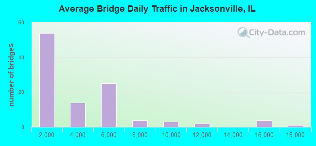
- 344,000Total average daily traffic
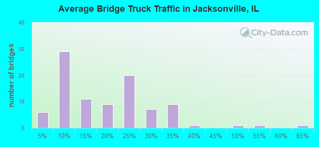
- 61,192Total average daily truck traffic
- National Bridge Inventory (NBI) Registered Bridges for Jacksonville
- No street view available for this location
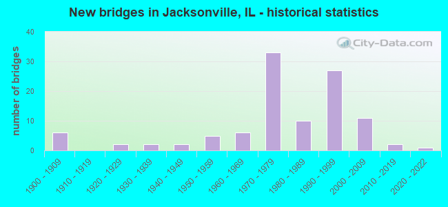
- New bridges - historical statistics
- 61900-1909
- 21920-1929
- 21930-1939
- 21940-1949
- 51950-1959
- 61960-1969
- 331970-1979
- 101980-1989
- 271990-1999
- 112000-2009
- 22010-2019
- 12020-2022
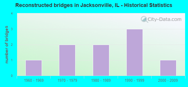
- Reconstructed bridges - Historical Statistics
- 11960-1969
- 21970-1979
- 21980-1989
- 31990-1999
- 12000-2009
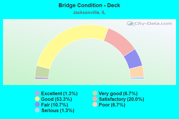
- Bridge Condition - Deck
- 1.3%Excellent
- 6.7%Very good
- 53.3%Good
- 20.0%Satisfactory
- 10.7%Fair
- 6.7%Poor
- 1.3%Serious
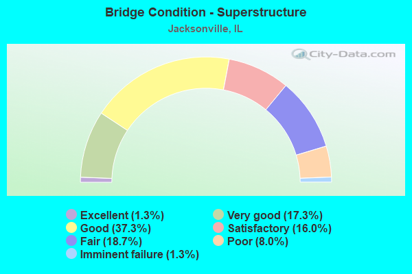
- Bridge Condition - Superstructure
- 1.3%Excellent
- 17.3%Very good
- 37.3%Good
- 16.0%Satisfactory
- 18.7%Fair
- 8.0%Poor
- 1.3%Imminent failure
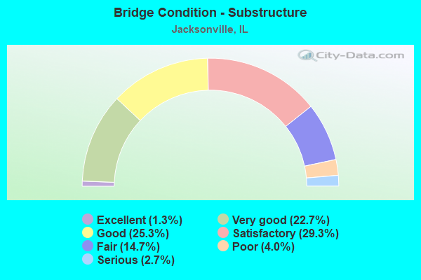
- Bridge Condition - Substructure
- 1.3%Excellent
- 22.7%Very good
- 25.3%Good
- 29.3%Satisfactory
- 14.7%Fair
- 4.0%Poor
- 2.7%Serious
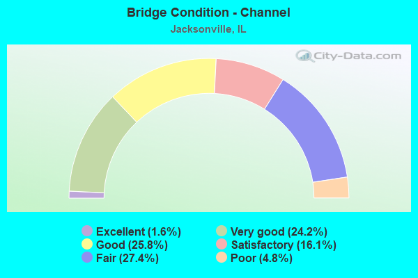
- Bridge Condition - Channel
- 1.6%Excellent
- 24.2%Very good
- 25.8%Good
- 16.1%Satisfactory
- 27.4%Fair
- 4.8%Poor
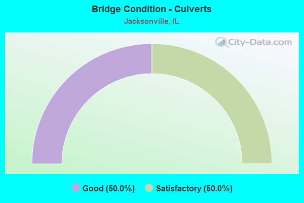
- Bridge Condition - Culverts
- 50.0%Good
- 50.0%Satisfactory
Find on map >> Show street view
Structure Number: 69603, Location: S JOHNSON @ BROOK (Lat: 39.730408, Lng: -90.210492), Route carried "on" structure: Other road , Year Built: 1997, Status: Open, Structure Length: 1.43m (4.69ft), Average Daily Traffic: 200 (year 2019), Truck Traffic: 12%, Average Future Daily Traffic: 398 (year 2032), Design Load: HS 20, Features Intersected: TOWN BROOK, Facility Carried by Structure: FAU8198/S JOHNSON
Minimum Vertical Clearance: 30+ m (98+ ft), Kilometerpoint: 1.078, Lanes on structure: 2, Owner: City or Municipal Highway Agency, Approaching Roadway Width: 6.7m (22.0ft), Material/Design: Prestressed concrete, Design/Construction: Box Beam or Girders - Multiple, Number Of Spans In Main Unit: 1, Length of Maximum Span: 13.6m (44.6ft), Curb-To-Curb Width: 9.1m (29.9ft), Out-to-Out Width: 9.1m (29.9ft)
Condition: Deck: Good, Superstructure: Good, Substructure: Fair, Channel: Fair, Operating Rating: 44.1 metric tons, Method Used To Determine Operating Rating: Assigned rating based on Load Factor Design (LFD) reported by rating factor (RF) using MS18 loading, Inventory Rating: 32.4 metric tons, Method Used To Determine Inventory Rating: Assigned rating based on Load Factor Design (LFD) reported by rating factor (RF) using MS18 loading, Structural Evaluation: Somewhat better than minimum adequacy, Deck Geometry: Equal to present minimum criteria, Waterway Adequacy: Equal to present desirable criteria, Approach Roadway Alignment: Equal to present desirable criteria, Designated Inspection Frequency: Every 24 months, Inspection Date: May 2020, Deck Structure Type: Concrete Precast Panels, Wearing Surface/Protective System: Wearing Surface: Bituminous, Membrane: Built-up
Find on map >> Show street view
Structure Number: 696031, Location: WADSWORTH DRIVE (Lat: 39.746600, Lng: -90.254406), Route carried "on" structure: City street , Year Built: 1996, Status: Open, Structure Length: 2.04m (6.69ft), Average Daily Traffic: 300 (year 2019), Average Future Daily Traffic: 31 (year 2032), Design Load: HS 20, Features Intersected: TRIB/MAUVAISE TERRE, Facility Carried by Structure: WADSWORTH DR.
Minimum Vertical Clearance: 30+ m (98+ ft), Kilometerpoint: 0.322, Lanes on structure: 2, Owner: City or Municipal Highway Agency, Approaching Roadway Width: 11.0m (36.1ft), Material/Design: Prestressed concrete, Design/Construction: Box Beam or Girders - Multiple, Number Of Spans In Main Unit: 1, Length of Maximum Span: 19.6m (64.3ft), Curb or Sidewalk Widths: Left: 1.2m (3.9ft), Right: 1.2m (3.9ft), Curb-To-Curb Width: 11.0m (36.1ft), Out-to-Out Width: 13.4m (44.0ft)
Condition: Deck: Satisfactory, Superstructure: Satisfactory, Substructure: Good, Channel: Fair, Operating Rating: 44.1 metric tons, Method Used To Determine Operating Rating: Assigned rating based on Load Factor Design (LFD) reported by rating factor (RF) using MS18 loading, Inventory Rating: 32.4 metric tons, Method Used To Determine Inventory Rating: Assigned rating based on Load Factor Design (LFD) reported by rating factor (RF) using MS18 loading, Structural Evaluation: Equal to present minimum criteria, Deck Geometry: Equal to present desirable criteria, Waterway Adequacy: Better than present minimum criteria, Approach Roadway Alignment: Equal to present minimum criteria, Designated Inspection Frequency: Every 24 months, Inspection Date: May 2020, Deck Structure Type: Concrete Precast Panels, Wearing Surface/Protective System: Wearing Surface: Bituminous, Membrane: Built-up
Find on map >> Show street view
Structure Number: 696032, Location: ON FAYETTE @ BROOK (Lat: 39.726750, Lng: -90.235147), Route carried "on" structure: City street , Year Built: 2002, Status: Open, Structure Length: 1.92m (6.30ft), Average Daily Traffic: 550 (year 2019), Truck Traffic: 5%, Average Future Daily Traffic: 1,540 (year 2032), Design Load: HS 20, Features Intersected: TOWN BROOK, Facility Carried by Structure: SO FAYETTE STREET
Minimum Vertical Clearance: 30+ m (98+ ft), Kilometerpoint: 1.352, Lanes on structure: 2, Owner: City or Municipal Highway Agency, Approaching Roadway Width: 7.3m (24.0ft), Skew: 3 degrees, Material/Design: Steel continuous, Design/Construction: Stringer/Multi-beam, Number Of Spans In Main Unit: 3, Length of Maximum Span: 18.2m (59.7ft), Curb-To-Curb Width: 10.4m (34.1ft), Out-to-Out Width: 11.0m (36.1ft)
Condition: Deck: Good, Superstructure: Very good, Substructure: Satisfactory, Channel: Fair, Operating Rating: 44.1 metric tons, Method Used To Determine Operating Rating: Assigned rating based on Load Factor Design (LFD) reported by rating factor (RF) using MS18 loading, Inventory Rating: 32.4 metric tons, Method Used To Determine Inventory Rating: Assigned rating based on Load Factor Design (LFD) reported by rating factor (RF) using MS18 loading, Structural Evaluation: Equal to present minimum criteria, Deck Geometry: Equal to present minimum criteria, Waterway Adequacy: Equal to present desirable criteria, Approach Roadway Alignment: Equal to present desirable criteria, Designated Inspection Frequency: Every 24 months, Inspection Date: May 2020, Deck Structure Type: Other, Wearing Surface/Protective System: Wearing Surface: Bituminous
Find on map >> Show street view
Structure Number: 696033, Location: ON W CHAMBERS@BROOK (Lat: 39.726992, Lng: -90.234753), Route carried "on" structure: City street , Year Built: 2005, Status: Open, Structure Length: 2.35m (7.71ft), Average Daily Traffic: 850 (year 2019), Truck Traffic: 6%, Average Future Daily Traffic: 1,062 (year 2032), Design Load: HS 20, Features Intersected: TOWN BROOK, Facility Carried by Structure: WEST CHAMBERS ST
Minimum Vertical Clearance: 30+ m (98+ ft), Kilometerpoint: 0.756, Lanes on structure: 2, Owner: City or Municipal Highway Agency, Approaching Roadway Width: 9.1m (29.9ft), Skew: 3 degrees, Material/Design: Prestressed concrete, Design/Construction: Box Beam or Girders - Multiple, Number Of Spans In Main Unit: 1, Length of Maximum Span: 22.4m (73.5ft), Curb-To-Curb Width: 9.2m (30.2ft), Out-to-Out Width: 9.2m (30.2ft)
Condition: Deck: Very good, Superstructure: Very good, Substructure: Very good, Channel: Fair, Operating Rating: 44.1 metric tons, Method Used To Determine Operating Rating: Assigned rating based on Load Factor Design (LFD) reported by rating factor (RF) using MS18 loading, Inventory Rating: 32.4 metric tons, Method Used To Determine Inventory Rating: Assigned rating based on Load Factor Design (LFD) reported by rating factor (RF) using MS18 loading, Structural Evaluation: Equal to present desirable criteria, Deck Geometry: Equal to present minimum criteria, Waterway Adequacy: Equal to present desirable criteria, Approach Roadway Alignment: Equal to present desirable criteria, Designated Inspection Frequency: Every 48 months, Inspection Date: May 2020, Deck Structure Type: Concrete Precast Panels, Wearing Surface/Protective System: Wearing Surface: Bituminous, Membrane: Built-up
Find on map >> Show street view
Structure Number: 699904, Location: .5 M N J'VILLE (Lat: 39.759836, Lng: -90.234339), Route carried "on" structure: County highway , Year Built: 1900, Status: Posted for load, Structure Length: 5.18m (16.99ft), Average Daily Traffic: 50 (year 2019), Average Future Daily Traffic: 53 (year 2032), Features Intersected: B&N RR, Facility Carried by Structure: TR 137
Minimum Vertical Clearance: 30+ m (98+ ft), Kilometerpoint: 0.209, Lanes on structure: 1, Owner: Railroad, Approaching Roadway Width: 3.4m (11.2ft), Skew: 3 degrees, Material/Design: Steel, Number Of Spans In Main Unit: 1, Number Of Approach Spans: 9, Length of Maximum Span: 15.2m (49.9ft), Curb-To-Curb Width: 4.9m (16.1ft), Out-to-Out Width: 5.5m (18.0ft)
Condition: Deck: Fair, Superstructure: Fair, Substructure: Serious, Operating Rating: 23.0 metric tons, Method Used To Determine Operating Rating: Allowable Stress (AS) rating reported by rating factor (RF) method using MS18 loading, Structural Evaluation: High priority of corrective action, Deck Geometry: High priority of corrective action, Underclear: Equal to present minimum criteria, Approach Roadway Alignment: High priority of corrective action, Bridge Posting: Required (Relationship of Operating Rating to Maximum Legal Load: > 39.9% below), Designated Inspection Frequency: Every 24 months, Critical Feature Inspection Frequency: Every 24 months, Other Special Inspection Frequency: Every 12 months, Inspection Date: November 2021, Critical Feature Inspection Date: April 2021, Other Special Inspection Date: August 2021, Deck Structure Type: Wood or Timber, Wearing Surface/Protective System: Wearing Surface: Wood or Timber
Find on map >> Show street view
Structure Number: 690008, Location: .5M E IL 267-JACKSNV (Lat: 39.723231, Lng: -90.219517), Route carried "under" structure: Business Interstate 72, Year Built: 1958, Structure Length: 0. m, Average Daily Traffic: 11,700 (year 2021), Truck Traffic: 7%, Features Intersected: BUS I72/IL104/MORTON, Facility Carried by Structure: GATEWAY WESTERN RR
Minimum Vertical Clearance: 4.37m (14.34ft), Kilometerpoint: 10.798, Lanes under structure: 4, Material/Design: Concrete, Design/Construction: Stringer/Multi-beam, Length of Maximum Span: 21.3m (69.9ft)
Find on map >> Show street view
Structure Number: 690012, Location: 1M E I-72/US 36 (Lat: 39.723011, Lng: -90.149450), Route carried "under" structure: County highway , Year Built: 1948, Structure Length: 0. m, Average Daily Traffic: 1,100 (year 2019), Truck Traffic: 7%, Features Intersected: OLD US 36, Facility Carried by Structure: NORFOLK SOUTHERN R
Minimum Vertical Clearance: 4.24m (13.91ft), Kilometerpoint: 1.577, Lanes under structure: 2, Material/Design: Steel, Design/Construction: Girder and Floorbeam System, Length of Maximum Span: 34.3m (112.5ft)
Find on map >> Show street view
Structure Number: 690037, Location: 1.8MI SW I72/OLD36 (Lat: 39.701619, Lng: -90.189131), Route carried "under" structure: Interstate 72, Year Built: 1975, Structure Length: 0. m, Average Daily Traffic: 9,800 (year 2021), Truck Traffic: 33%, Features Intersected: FAI 72, Facility Carried by Structure: TR 195
Minimum Vertical Clearance: 4.95m (16.24ft), Kilometerpoint: 108.579, Lanes on structure: 2, Lanes under structure: 4, Material/Design: Steel continuous, Design/Construction: Stringer/Multi-beam, Length of Maximum Span: 33.5m (109.9ft)
Find on map >> Show street view
Structure Number: 69004, Location: 1.1MI SW I72/OLD36 (Lat: 39.710161, Lng: -90.180408), Route carried "under" structure: State highway 104, Year Built: 1975, Structure Length: 0. m, Average Daily Traffic: 2,750 (year 2021), Truck Traffic: 29%, Features Intersected: ILL 104 & B&N RR, Facility Carried by Structure: FAI 72 EB
Minimum Vertical Clearance: 7.37m (24.18ft), Kilometerpoint: 121.470, Lanes on structure: 2, Lanes under structure: 2, Material/Design: Steel continuous, Design/Construction: Stringer/Multi-beam, Length of Maximum Span: 33.8m (110.9ft)
Find on map >> Show street view
Structure Number: 690041, Location: 1.1MI SW I72/OLD36 (Lat: 39.710431, Lng: -90.180803), Route carried "under" structure: State highway 104, Year Built: 1975, Structure Length: 0. m, Average Daily Traffic: 2,750 (year 2021), Truck Traffic: 29%, Features Intersected: ILL 104 & B&N RR, Facility Carried by Structure: FAI 72 WB
Minimum Vertical Clearance: 7.70m (25.26ft), Kilometerpoint: 121.438, Lanes on structure: 2, Lanes under structure: 2, Material/Design: Steel continuous, Design/Construction: Stringer/Multi-beam, Length of Maximum Span: 33.8m (110.9ft)
Find on map >> Show street view
Structure Number: 690044, Location: I72/BUS I72 INT #68 (Lat: 39.723011, Lng: -90.167731), Route carried "under" structure: Interstate 72, Year Built: 1975, Structure Length: 0. m, Average Daily Traffic: 15,000 (year 2021), Truck Traffic: 24%, Features Intersected: FAI 72
Minimum Vertical Clearance: 5.23m (17.16ft), Kilometerpoint: 111.637, Lanes on structure: 4, Lanes under structure: 4, Material/Design: Steel continuous, Design/Construction: Stringer/Multi-beam, Length of Maximum Span: 38.1m (125.0ft)
Find on map >> Show street view
Structure Number: 690045, Location: .4M NE I72/BUS I72 (Lat: 39.728022, Lng: -90.162703), Route carried "under" structure: Interstate 72, Year Built: 1975, Structure Length: 0. m, Average Daily Traffic: 15,000 (year 2021), Truck Traffic: 24%, Features Intersected: FAI 72, Facility Carried by Structure: N&W RR
Minimum Vertical Clearance: 5.11m (16.77ft), Kilometerpoint: 112.345, Lanes under structure: 4, Material/Design: Steel, Design/Construction: Girder and Floorbeam System, Length of Maximum Span: 31.5m (103.3ft)
Find on map >> Show street view
Structure Number: 690047, Location: 1MI E I72/BUS I72 (Lat: 39.734817, Lng: -90.155303), Route carried "under" structure: Interstate 72, Year Built: 1975, Structure Length: 0. m, Average Daily Traffic: 15,000 (year 2021), Truck Traffic: 24%, Features Intersected: FAI 72, Facility Carried by Structure: TR 232
Minimum Vertical Clearance: 5.49m (18.01ft), Kilometerpoint: 113.327, Lanes on structure: 2, Lanes under structure: 4, Material/Design: Steel continuous, Design/Construction: Stringer/Multi-beam, Length of Maximum Span: 34.1m (111.9ft)
Find on map >> Show street view
Structure Number: 69005, Location: 2.5MI E I72/BUS I72 (Lat: 39.737789, Lng: -90.126311), Route carried "under" structure: Interstate 72, Year Built: 1975, Structure Length: 0. m, Average Daily Traffic: 15,000 (year 2021), Truck Traffic: 24%, Features Intersected: FAI 72, Facility Carried by Structure: TR 284
Minimum Vertical Clearance: 5.23m (17.16ft), Kilometerpoint: 115.902, Lanes on structure: 2, Lanes under structure: 4, Material/Design: Steel continuous, Design/Construction: Stringer/Multi-beam, Length of Maximum Span: 32.8m (107.6ft)
Find on map >> Show street view
Structure Number: 690055, Location: 2.75 MI W ILL 267 (Lat: 39.680569, Lng: -90.294850), Route carried "under" structure: Business Interstate 72, Year Built: 1977, Structure Length: 0. m, Average Daily Traffic: 5,350 (year 2021), Truck Traffic: 16%, Features Intersected: US 67
Minimum Vertical Clearance: 5.31m (17.42ft), Kilometerpoint: 0.016, Lanes on structure: 2, Lanes under structure: 4, Material/Design: Steel continuous, Design/Construction: Stringer/Multi-beam, Length of Maximum Span: 36.4m (119.4ft)
Find on map >> Show street view
Structure Number: 690056, Location: 2.75 MI W ILL 267 (Lat: 39.680236, Lng: -90.294853), Route carried "under" structure: US 67, Year Built: 1977, Structure Length: 0. m, Average Daily Traffic: 5,350 (year 2021), Truck Traffic: 16%, Features Intersected: US 67, Facility Carried by Structure: FAI 72 EB
Minimum Vertical Clearance: 5.49m (18.01ft), Kilometerpoint: 101.820, Lanes on structure: 2, Lanes under structure: 4, Material/Design: Steel continuous, Design/Construction: Stringer/Multi-beam, Length of Maximum Span: 36.4m (119.4ft)
Find on map >> Show street view
Structure Number: 690072, Location: 5.2MN US67/I72/US36 (Lat: 39.752147, Lng: -90.304150), Route carried "under" structure: US 67, Year Built: 1998, Structure Length: 0. m, Average Daily Traffic: 4,850 (year 2021), Truck Traffic: 23%, Features Intersected: US 67/IL 104, Facility Carried by Structure: TR 96
Minimum Vertical Clearance: 4.98m (16.34ft), Kilometerpoint: 110.237, Lanes on structure: 2, Lanes under structure: 5, Material/Design: Prestressed concrete, Design/Construction: Stringer/Multi-beam, Length of Maximum Span: 39.5m (129.6ft)
Find on map >> Show street view
Structure Number: 690073, Location: 4.7M N US67/I72/US36 (Lat: 39.748631, Lng: -90.295806), Route carried "under" structure: Other road , Year Built: 1998, Structure Length: 0. m, Average Daily Traffic: 225 (year 2008), Truck Traffic: 27%, Features Intersected: IL104EB & 104WB RAMP, Facility Carried by Structure: US 67 SB
Minimum Vertical Clearance: 4.98m (16.34ft), Kilometerpoint: 0.917, Lanes on structure: 2, Lanes under structure: 1, Material/Design: Prestressed concrete, Design/Construction: Stringer/Multi-beam, Length of Maximum Span: 28.4m (93.2ft)
Find on map >> Show street view
Structure Number: 690073, Location: 4.7M N US67/I72/US36 (Lat: 39.748483, Lng: -90.295714), Route carried "under" structure: State highway 104, Year Built: 1998, Structure Length: 0. m, Average Daily Traffic: 3,200 (year 2021), Truck Traffic: 16%, Features Intersected: IL104EB & 104WB RAMP, Facility Carried by Structure: US 67 SB
Minimum Vertical Clearance: 4.98m (16.34ft), Kilometerpoint: 107.936, Lanes on structure: 2, Lanes under structure: 1, Material/Design: Prestressed concrete, Design/Construction: Stringer/Multi-beam, Length of Maximum Span: 28.4m (93.2ft)
Find on map >> Show street view
Structure Number: 690074, Location: 4.7M N US67/I72/US36 (Lat: 39.748769, Lng: -90.295578), Route carried "under" structure: Other road , Year Built: 1998, Structure Length: 0. m, Average Daily Traffic: 225 (year 2008), Truck Traffic: 27%, Features Intersected: IL104EB & 104WB RAMP, Facility Carried by Structure: US 67 NB
Minimum Vertical Clearance: 4.98m (16.34ft), Kilometerpoint: 0.869, Lanes on structure: 2, Lanes under structure: 1, Material/Design: Prestressed concrete, Design/Construction: Stringer/Multi-beam, Length of Maximum Span: 29.0m (95.1ft)
Find on map >> Show street view
Structure Number: 690074, Location: 4.7M N US67/I72/US36 (Lat: 39.748628, Lng: -90.295483), Route carried "under" structure: State highway 104, Year Built: 1998, Structure Length: 0. m, Average Daily Traffic: 3,200 (year 2021), Truck Traffic: 16%, Features Intersected: IL104EB & 104WB RAMP, Facility Carried by Structure: US 67 NB
Minimum Vertical Clearance: 4.98m (16.34ft), Kilometerpoint: 107.968, Lanes on structure: 2, Lanes under structure: 1, Material/Design: Prestressed concrete, Design/Construction: Stringer/Multi-beam, Length of Maximum Span: 29.0m (95.1ft)
Find on map >> Show street view
Structure Number: 690077, Location: 3.9M N US67/I72/US36 (Lat: 39.737992, Lng: -90.294969), Route carried "under" structure: US 67, Year Built: 1998, Structure Length: 0. m, Average Daily Traffic: 4,850 (year 2021), Truck Traffic: 23%, Features Intersected: US 67, Facility Carried by Structure: TR 157
Minimum Vertical Clearance: 4.98m (16.34ft), Kilometerpoint: 108.209, Lanes on structure: 2, Lanes under structure: 4, Material/Design: Prestressed concrete, Design/Construction: Stringer/Multi-beam, Length of Maximum Span: 30.9m (101.4ft)
Find on map >> Show street view
Structure Number: 690078, Location: 2.6M N US67/I72/US36 (Lat: 39.720044, Lng: -90.294881), Route carried "under" structure: Business Interstate 72, Year Built: 1998, Structure Length: 0. m, Average Daily Traffic: 5,350 (year 2021), Truck Traffic: 16%, Features Intersected: US 67
Minimum Vertical Clearance: 5.13m (16.83ft), Kilometerpoint: 4.393, Lanes on structure: 2, Lanes under structure: 4, Material/Design: Prestressed concrete, Design/Construction: Stringer/Multi-beam, Length of Maximum Span: 39.1m (128.3ft)
Find on map >> Show street view
Structure Number: 690079, Location: 1.4M N US67/I72/US36 (Lat: 39.701578, Lng: -90.294931), Route carried "under" structure: Business Interstate 72, Year Built: 1998, Structure Length: 0. m, Average Daily Traffic: 5,350 (year 2021), Truck Traffic: 16%, Features Intersected: US 67, Facility Carried by Structure: TR 187
Minimum Vertical Clearance: 4.93m (16.17ft), Kilometerpoint: 2.333, Lanes on structure: 2, Lanes under structure: 4, Material/Design: Prestressed concrete, Design/Construction: Stringer/Multi-beam, Length of Maximum Span: 36.7m (120.4ft)
Find on map >> Show street view
Structure Number: 690521, Location: .3M N MORTON-JACKSVL (Lat: 39.727075, Lng: -90.273711), Route carried "under" structure: State highway 104, Year Built: 2011, Structure Length: 0. m, Average Daily Traffic: 2,700 (year 2021), Truck Traffic: 10%, Features Intersected: IL 104, Facility Carried by Structure: MOUND ROAD
Minimum Vertical Clearance: 30.18m (99.02ft), Kilometerpoint: 112.474, Lanes on structure: 2, Lanes under structure: 2, Material/Design: Steel continuous, Design/Construction: Stringer/Multi-beam, Length of Maximum Span: 19.5m (64.0ft)
Find on map >> Show street view
Structure Number: 696, Location: E EDGE OF J'VILLE (Lat: 39.734961, Lng: -90.206758), Route carried "under" structure: Other road , Year Built: 1900, Structure Length: 0. m, Average Daily Traffic: 300 (year 2014), Truck Traffic: 7%, Features Intersected: OR 613, Facility Carried by Structure: N&W RR
Minimum Vertical Clearance: 3.81m (12.50ft), Kilometerpoint: 0.579, Lanes under structure: 2, Material/Design: Steel, Design/Construction: Stringer/Multi-beam, Length of Maximum Span: 12.2m (40.0ft)
Find on map >> Show street view
Structure Number: 696022, Location: NW WESTGATE ST J'VLE (Lat: 39.743842, Lng: -90.261614), Route carried "under" structure: Other road , Year Built: 1977, Structure Length: 0. m, Average Daily Traffic: 5,800 (year 2019), Truck Traffic: 4%, Features Intersected: FAU 8180 WESTGATE, Facility Carried by Structure: N&W RR
Minimum Vertical Clearance: 17.68m (58.01ft), Kilometerpoint: 0.161, Lanes under structure: 4, Material/Design: Steel, Design/Construction: Girder and Floorbeam System, Length of Maximum Span: 19.2m (63.0ft)
Find on map >> Show street view
Structure Number: 6999, Location: IL 78 N J'VILLE (Lat: 39.753953, Lng: -90.229100), Route carried "under" structure: State highway 78, Year Built: 1900, Structure Length: 0. m, Average Daily Traffic: 3,000 (year 2021), Truck Traffic: 8%, Features Intersected: FAP 4, Facility Carried by Structure: B&N RR
Minimum Vertical Clearance: 4.11m (13.48ft), Kilometerpoint: 5.826, Lanes under structure: 2, Material/Design: Steel, Design/Construction: Stringer/Multi-beam, Length of Maximum Span: 27.4m (89.9ft)
Find on map >> Show street view
Structure Number: 699902, Location: 1MI SO ILL 104 (Lat: 39.746336, Lng: -90.323053), Route carried "under" structure: County highway , Year Built: 1900, Structure Length: 0. m, Average Daily Traffic: 50 (year 2019), Features Intersected: TR 78, Facility Carried by Structure: N&W RR
Minimum Vertical Clearance: 3.94m (12.93ft), Kilometerpoint: 6.936, Lanes under structure: 2, Material/Design: Steel, Design/Construction: Stringer/Multi-beam, Length of Maximum Span: 5.5m (18.0ft)