Bridge Statistics for Jersey City, New Jersey (NJ)
Condition, Traffic, Stress, Structural Evaluation, Project Costs
- National Bridge Inventory (NBI) Statistics
- 180Number of bridges
- 6,053ft / 1,845mTotal length
- $471,236,000Total costs
- 3,642,138Total average daily traffic
- 219,597Total average daily truck traffic
- National Bridge Inventory (NBI) Registered Bridges for Jersey City
- No street view available for this location
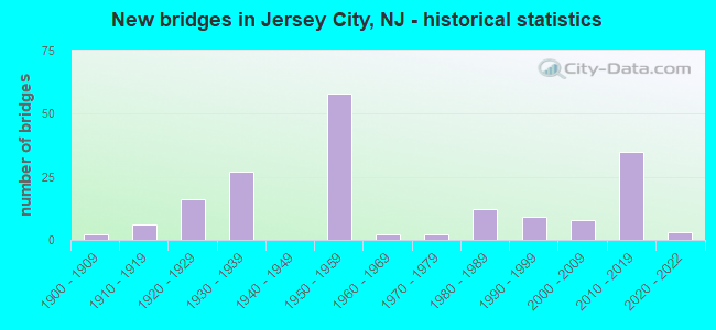
- New bridges - historical statistics
- 21900-1909
- 61910-1919
- 161920-1929
- 271930-1939
- 581950-1959
- 21960-1969
- 21970-1979
- 121980-1989
- 91990-1999
- 82000-2009
- 352010-2019
- 32020-2022
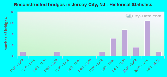
- Reconstructed bridges - Historical Statistics
- 11900-1909
- 01910-1919
- 01920-1929
- 11930-1939
- 01940-1949
- 01950-1959
- 01960-1969
- 11970-1979
- 41980-1989
- 61990-1999
- 22000-2009
- 82010-2019
- 12020-2022
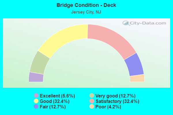
- Bridge Condition - Deck
- 5.6%Excellent
- 12.7%Very good
- 32.4%Good
- 32.4%Satisfactory
- 12.7%Fair
- 4.2%Poor
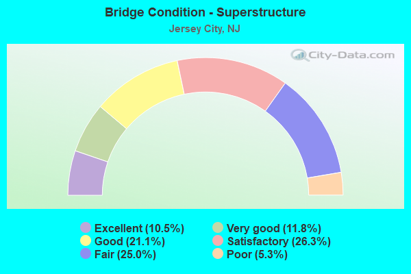
- Bridge Condition - Superstructure
- 10.5%Excellent
- 11.8%Very good
- 21.1%Good
- 26.3%Satisfactory
- 25.0%Fair
- 5.3%Poor
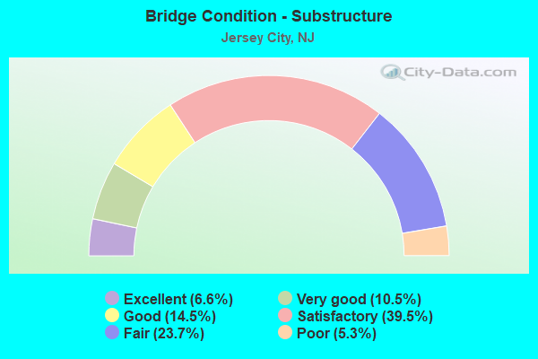
- Bridge Condition - Substructure
- 6.6%Excellent
- 10.5%Very good
- 14.5%Good
- 39.5%Satisfactory
- 23.7%Fair
- 5.3%Poor
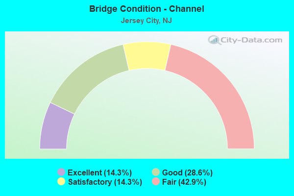
- Bridge Condition - Channel
- 14.3%Excellent
- 28.6%Good
- 14.3%Satisfactory
- 42.9%Fair
Find on map >> Show street view
Structure Number: N00649, Location: 2 MI SW OF HOLLAND TUNNEL (Lat: 40.712144, Lng: -74.054119), Route carried "under" structure: City street , Year Built: 1955, Structure Length: 0. m, Average Daily Traffic: 5,998 (year 2020), Truck Traffic: 1%, Features Intersected: RR & 5 ROADS, Facility Carried by Structure: NJ TPK HUD.CO.EXT.
Minimum Vertical Clearance: 10.90m (35.76ft), Kilometerpoint: 1.304, Lanes on structure: 5, Lanes under structure: 2, Material/Design: Steel continuous, Design/Construction: Girder and Floorbeam System, Length of Maximum Span: 50.9m (167.0ft)
Find on map >> Show street view
Structure Number: N00649, Location: 2 MI SW OF HOLLAND TUNNEL (Lat: 40.712144, Lng: -74.054119), Route carried "under" structure: City street , Year Built: 1955, Structure Length: 0. m, Average Daily Traffic: 1,301 (year 2020), Features Intersected: RR & 5 ROADS, Facility Carried by Structure: NJ TPK HUD.CO.EXT.
Minimum Vertical Clearance: 8.84m (29.00ft), Kilometerpoint: 0.000, Lanes on structure: 5, Lanes under structure: 4, Material/Design: Steel continuous, Design/Construction: Girder and Floorbeam System, Length of Maximum Span: 50.9m (167.0ft)
Find on map >> Show street view
Structure Number: N00680E, Location: 1.6 MI SW HOLLAND TUNNEL (Lat: 40.717783, Lng: -74.055758), Route carried "under" structure: City street , Year Built: 1955, Structure Length: 0. m, Average Daily Traffic: 816 (year 2020), Truck Traffic: 1%, Features Intersected: COLDEN ST, GRAND ST, Facility Carried by Structure: GRAND ST OFF RAMP
Minimum Vertical Clearance: 4.36m (14.30ft), Kilometerpoint: 0.000, Lanes on structure: 2, Lanes under structure: 2, Material/Design: Steel continuous, Design/Construction: Stringer/Multi-beam, Length of Maximum Span: 27.1m (88.9ft)
Find on map >> Show street view
Structure Number: N00680E, Location: 1.6 MI SW HOLLAND TUNNEL (Lat: 40.717783, Lng: -74.055758), Route carried "under" structure: County highway 622, Year Built: 1955, Structure Length: 0. m, Average Daily Traffic: 24,634 (year 2020), Truck Traffic: 1%, Features Intersected: COLDEN ST, GRAND ST, Facility Carried by Structure: GRAND ST OFF RAMP
Minimum Vertical Clearance: 7.37m (24.18ft), Kilometerpoint: 0.547, Lanes on structure: 2, Lanes under structure: 5, Material/Design: Steel continuous, Design/Construction: Stringer/Multi-beam, Length of Maximum Span: 27.1m (88.9ft)
Find on map >> Show street view
Structure Number: N00680W, Location: 1.6 MI SW HOLLAND TUNNEL (Lat: 40.717853, Lng: -74.056192), Route carried "under" structure: City street , Year Built: 1955, Structure Length: 0. m, Average Daily Traffic: 24,634 (year 2020), Features Intersected: COLDEN ST,GRAND ST, Facility Carried by Structure: GRAND ST ON RAMP
Minimum Vertical Clearance: 7.77m (25.49ft), Kilometerpoint: 0.547, Lanes on structure: 1, Lanes under structure: 5, Material/Design: Steel continuous, Design/Construction: Stringer/Multi-beam, Length of Maximum Span: 27.1m (88.9ft)
Find on map >> Show street view
Structure Number: N00680W, Location: 1.6 MI SW HOLLAND TUNNEL (Lat: 40.717853, Lng: -74.056192), Route carried "under" structure: City street , Year Built: 1955, Structure Length: 0. m, Average Daily Traffic: 832 (year 2020), Features Intersected: COLDEN ST,GRAND ST, Facility Carried by Structure: GRAND ST ON RAMP
Minimum Vertical Clearance: 4.67m (15.32ft), Kilometerpoint: 0.000, Lanes on structure: 1, Lanes under structure: 2, Material/Design: Steel continuous, Design/Construction: Stringer/Multi-beam, Length of Maximum Span: 27.1m (88.9ft)
Find on map >> Show street view
Structure Number: N00713, Location: 1 MI SW OF HOLLAND TUNNEL (Lat: 40.717586, Lng: -74.056000), Route carried "under" structure: City street , Year Built: 1955, Structure Length: 0. m, Average Daily Traffic: 1,560 (year 2020), Truck Traffic: 1%, Features Intersected: CONRAIL WALDO YARD & STS, Facility Carried by Structure: NJ TPK HUD.CO.EXT.
Minimum Vertical Clearance: 7.21m (23.65ft), Kilometerpoint: 0.000, Lanes on structure: 4, Lanes under structure: 2, Material/Design: Steel continuous, Design/Construction: Stringer/Multi-beam, Length of Maximum Span: 50.3m (165.0ft)
Find on map >> Show street view
Structure Number: N00713, Location: 1 MI SW OF HOLLAND TUNNEL (Lat: 40.717586, Lng: -74.056000), Route carried "under" structure: City street , Year Built: 1955, Structure Length: 0. m, Average Daily Traffic: 3,268 (year 2020), Truck Traffic: 1%, Features Intersected: CONRAIL WALDO YARD & STS, Facility Carried by Structure: NJ TPK HUD.CO.EXT.
Minimum Vertical Clearance: 10.36m (33.99ft), Kilometerpoint: 1.915, Lanes on structure: 4, Lanes under structure: 4, Toll: On toll road, Material/Design: Steel continuous, Design/Construction: Stringer/Multi-beam, Length of Maximum Span: 50.3m (165.0ft)
Find on map >> Show street view
Structure Number: N00713, Location: 1 MI SW OF HOLLAND TUNNEL (Lat: 40.717586, Lng: -74.056000), Route carried "under" structure: City street , Year Built: 1955, Structure Length: 0. m, Average Daily Traffic: 1,570 (year 2020), Features Intersected: CONRAIL WALDO YARD & STS, Facility Carried by Structure: NJ TPK HUD.CO.EXT.
Minimum Vertical Clearance: 16.92m (55.51ft), Kilometerpoint: 0.274, Lanes on structure: 4, Lanes under structure: 4, Material/Design: Steel continuous, Design/Construction: Stringer/Multi-beam, Length of Maximum Span: 50.3m (165.0ft)
Find on map >> Show street view
Structure Number: N00752, Location: .5 MI SW HOLLAND TUNNEL (Lat: 40.726578, Lng: -74.053125), Route carried "under" structure: City street , Year Built: 1955, Structure Length: 0. m, Average Daily Traffic: 20,160 (year 2020), Features Intersected: NEWARK,7TH,3RD,&CONRAIL, Facility Carried by Structure: NJ TPK HUD.CO.EXT.
Minimum Vertical Clearance: 14.07m (46.16ft), Kilometerpoint: 1.159, Lanes on structure: 4, Lanes under structure: 2, Toll: On toll road, Material/Design: Steel continuous, Design/Construction: Stringer/Multi-beam, Length of Maximum Span: 36.6m (120.1ft)
Find on map >> Show street view
Structure Number: N00752, Location: .5 MI SW HOLLAND TUNNEL (Lat: 40.726578, Lng: -74.053125), Route carried "under" structure: City street , Year Built: 1955, Structure Length: 0. m, Average Daily Traffic: 1,636 (year 2020), Features Intersected: NEWARK,7TH,3RD,&CONRAIL, Facility Carried by Structure: NJ TPK HUD.CO.EXT.
Minimum Vertical Clearance: 20.52m (67.32ft), Kilometerpoint: 0.000, Lanes on structure: 4, Lanes under structure: 2, Toll: On toll road, Material/Design: Steel continuous, Design/Construction: Stringer/Multi-beam, Length of Maximum Span: 36.6m (120.1ft)
Find on map >> Show street view
Structure Number: N00752, Location: .5 MI SW HOLLAND TUNNEL (Lat: 40.726578, Lng: -74.053125), Route carried "under" structure: City street , Year Built: 1955, Structure Length: 0. m, Average Daily Traffic: 1,636 (year 2020), Features Intersected: NEWARK,7TH,3RD,&CONRAIL, Facility Carried by Structure: NJ TPK HUD.CO.EXT.
Minimum Vertical Clearance: 13.92m (45.67ft), Kilometerpoint: 0.000, Lanes on structure: 4, Lanes under structure: 1, Material/Design: Steel continuous, Design/Construction: Stringer/Multi-beam, Length of Maximum Span: 36.6m (120.1ft)
Find on map >> Show street view
Structure Number: N00790E, Location: .2 MI SW HOLLAND TUNNEL (Lat: 40.730278, Lng: -74.051336), Route carried "under" structure: City street , Year Built: 1955, Structure Length: 0. m, Average Daily Traffic: 1,668 (year 2020), Features Intersected: MONMOUTH,COLES,& CONRAIL, Facility Carried by Structure: NJ TPK HUD.CO.EXT.
Minimum Vertical Clearance: 6.17m (20.24ft), Kilometerpoint: 0.000, Lanes on structure: 2, Lanes under structure: 2, Toll: On toll road, Material/Design: Steel, Design/Construction: Stringer/Multi-beam, Length of Maximum Span: 64.0m (210.0ft)
Find on map >> Show street view
Structure Number: N00790E, Location: .2 MI SW HOLLAND TUNNEL (Lat: 40.730278, Lng: -74.051336), Route carried "under" structure: City street , Year Built: 1955, Structure Length: 0. m, Average Daily Traffic: 1,668 (year 2020), Features Intersected: MONMOUTH,COLES,& CONRAIL, Facility Carried by Structure: NJ TPK HUD.CO.EXT.
Minimum Vertical Clearance: 4.04m (13.25ft), Kilometerpoint: 0.000, Lanes on structure: 2, Lanes under structure: 2, Toll: On toll road, Material/Design: Steel, Design/Construction: Stringer/Multi-beam, Length of Maximum Span: 64.0m (210.0ft)
Find on map >> Show street view
Structure Number: N00793W, Location: .1 MI SW HOLLAND TUNNEL (Lat: 40.731867, Lng: -74.050378), Route carried "under" structure: City street , Year Built: 1954, Structure Length: 0. m, Average Daily Traffic: 1,635 (year 2020), Truck Traffic: 1%, Features Intersected: COLES ST & CONRAIL, Facility Carried by Structure: NJ TPK HUD.CO.EXT.
Minimum Vertical Clearance: 4.22m (13.85ft), Kilometerpoint: 0.000, Lanes on structure: 2, Lanes under structure: 2, Material/Design: Steel, Design/Construction: Stringer/Multi-beam, Length of Maximum Span: 52.4m (171.9ft)
Find on map >> Show street view
Structure Number: N0353FR, Location: 1.5 MI E OF NEWARK BAY (Lat: 40.680478, Lng: -74.098872), Route carried "under" structure: State highway 440, Year Built: 2017, Structure Length: 0. m, Average Daily Traffic: 29,715 (year 2020), Truck Traffic: 4%, Features Intersected: NJ440,AVE.E CIR,RR, Facility Carried by Structure: TPK HCE INT 14A
Minimum Vertical Clearance: 7.39m (24.25ft), Kilometerpoint: 35.325, Lanes on structure: 4, Lanes under structure: 8, Material/Design: Steel continuous, Design/Construction: Stringer/Multi-beam, Length of Maximum Span: 49.7m (163.1ft)
Find on map >> Show street view
Structure Number: N0353FR, Location: 1.5 MI E OF NEWARK BAY (Lat: 40.680478, Lng: -74.098872), Route carried "under" structure: City street , Year Built: 2017, Structure Length: 0. m, Average Daily Traffic: 11,840 (year 2020), Truck Traffic: 2%, Features Intersected: NJ440,AVE.E CIR,RR, Facility Carried by Structure: TPK HCE INT 14A
Minimum Vertical Clearance: 5.97m (19.59ft), Kilometerpoint: 4.152, Lanes on structure: 4, Lanes under structure: 3, Material/Design: Steel continuous, Design/Construction: Stringer/Multi-beam, Length of Maximum Span: 49.7m (163.1ft)