Bridge Statistics for Kalamazoo, Michigan (MI)
Condition, Traffic, Stress, Structural Evaluation, Project Costs
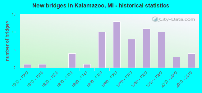
- New bridges - historical statistics
- 11900-1909
- 11910-1919
- 41930-1939
- 11940-1949
- 101950-1959
- 131960-1969
- 81970-1979
- 111980-1989
- 101990-1999
- 32000-2009
- 42010-2019
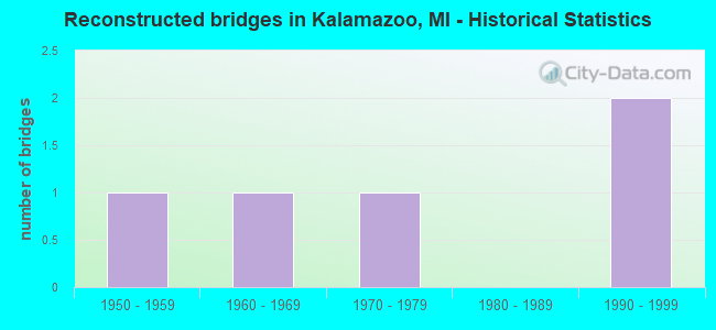
- Reconstructed bridges - Historical Statistics
- 11950-1959
- 11960-1969
- 11970-1979
- 01980-1989
- 21990-1999
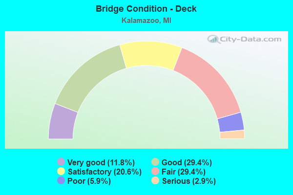
- Bridge Condition - Deck
- 11.8%Very good
- 29.4%Good
- 20.6%Satisfactory
- 29.4%Fair
- 5.9%Poor
- 2.9%Serious
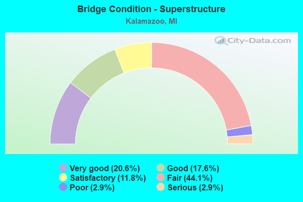
- Bridge Condition - Superstructure
- 20.6%Very good
- 17.6%Good
- 11.8%Satisfactory
- 44.1%Fair
- 2.9%Poor
- 2.9%Serious
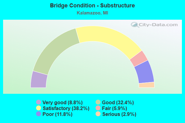
- Bridge Condition - Substructure
- 8.8%Very good
- 32.4%Good
- 38.2%Satisfactory
- 5.9%Fair
- 11.8%Poor
- 2.9%Serious
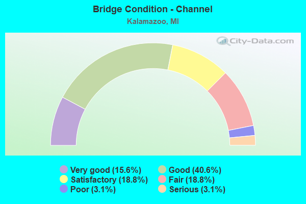
- Bridge Condition - Channel
- 15.6%Very good
- 40.6%Good
- 18.8%Satisfactory
- 18.8%Fair
- 3.1%Poor
- 3.1%Serious
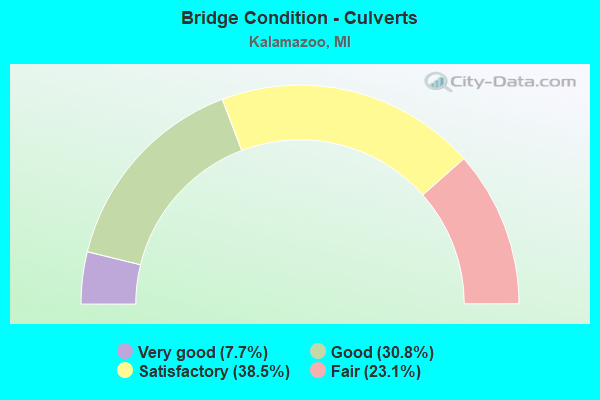
- Bridge Condition - Culverts
- 7.7%Very good
- 30.8%Good
- 38.5%Satisfactory
- 23.1%Fair
Find on map >> Show street view
Structure Number: 12881, Location: KALAMAZOO TWP SEC 24 (Lat: 42.278675, Lng: -85.539447), Route carried "on" structure: County highway , Year Built: 1979, Status: Open, Structure Length: 0.61m (2.00ft), Average Daily Traffic: 150 (year 2007), Truck Traffic: 1%, Average Future Daily Traffic: 200 (year 2027), Design Load: HS 20, Features Intersected: DAVIS CREEK, Facility Carried by Structure: SPRINGFIELD AVENUE
Minimum Vertical Clearance: 30.48m (100.00ft), Kilometerpoint: 0.097, Lanes on structure: 2, Owner: County Highway Agency, Approaching Roadway Width: 6.1m (20.0ft), Material/Design: Steel, Design/Construction: Culvert, Number Of Spans In Main Unit: 3, Length of Maximum Span: 1.6m (5.2ft)
Condition: Channel: Poor, Culverts: Fair, Operating Rating: 97.2 metric tons, Method Used To Determine Operating Rating: Load Factor (LF) rating reported by rating factor (RF) method using MS18 loading, Inventory Rating: 97.2 metric tons, Method Used To Determine Inventory Rating: Load Factor (LF) rating reported by rating factor (RF) method using MS18 loading, Structural Evaluation: Somewhat better than minimum adequacy, Waterway Adequacy: Better than present minimum criteria, Approach Roadway Alignment: Equal to present desirable criteria, Designated Inspection Frequency: Every 24 months, Inspection Date: October 2020
Find on map >> Show street view
Structure Number: 12882, Location: KALAMAZOO TWP SEC 24 (Lat: 42.279586, Lng: -85.540000), Route carried "on" structure: County highway , Year Built: 1973, Status: Open, Structure Length: 0.69m (2.26ft), Average Daily Traffic: 150 (year 2007), Truck Traffic: 1%, Average Future Daily Traffic: 200 (year 2027), Design Load: HS 20, Features Intersected: DAVIS CREEK, Facility Carried by Structure: BROOKFIELD AVENUE
Minimum Vertical Clearance: 30.48m (100.00ft), Kilometerpoint: 0.060, Lanes on structure: 2, Owner: County Highway Agency, Approaching Roadway Width: 7.3m (24.0ft), Skew: 2 degrees, Material/Design: Steel, Design/Construction: Culvert, Number Of Spans In Main Unit: 3, Length of Maximum Span: 1.9m (6.2ft)
Condition: Channel: Fair, Culverts: Fair, Operating Rating: 97.2 metric tons, Method Used To Determine Operating Rating: Load Factor (LF) rating reported by rating factor (RF) method using MS18 loading, Inventory Rating: 97.2 metric tons, Method Used To Determine Inventory Rating: Load Factor (LF) rating reported by rating factor (RF) method using MS18 loading, Structural Evaluation: Somewhat better than minimum adequacy, Waterway Adequacy: Better than present minimum criteria, Approach Roadway Alignment: Equal to present desirable criteria, Designated Inspection Frequency: Every 24 months, Inspection Date: October 2020
Find on map >> Show street view
Structure Number: 13139, Location: S OF PARKVIEW (Lat: 42.255314, Lng: -85.641950), Route carried "on" structure: ServiceCity street , Year Built: 2001, Status: Open, Structure Length: 1.09m (3.58ft), Average Daily Traffic: 5,000 (year 2002), Truck Traffic: 5%, Average Future Daily Traffic: 7,500 (year 2020), Design Load: HS 20, Features Intersected: PEDESTRIAN WALKWAY, Facility Carried by Structure: DRAKE ROAD
Minimum Vertical Clearance: 30.48m (100.00ft), Kilometerpoint: 0.842, Lanes on structure: 2, Owner: City or Municipal Highway Agency, Approaching Roadway Width: 11.3m (37.1ft), Material/Design: Concrete, Design/Construction: Culvert, Number Of Spans In Main Unit: 1, Length of Maximum Span: 10.9m (35.8ft), Curb-To-Curb Width: 9.8m (32.2ft), Out-to-Out Width: 11.4m (37.4ft)
Condition: Culverts: Very good, Operating Rating: 54.5 metric tons, Method Used To Determine Operating Rating: Field evaluation and documented engineering judgment, Inventory Rating: 32.7 metric tons, Method Used To Determine Inventory Rating: Field evaluation and documented engineering judgment, Structural Evaluation: Equal to present desirable criteria, Deck Geometry: Meets minimum limits, Approach Roadway Alignment: Equal to present desirable criteria, Designated Inspection Frequency: Every 24 months, Inspection Date: June 2020, Deck Structure Type: Concrete Cast-file-Place, Wearing Surface/Protective System: Wearing Surface: Bituminous
Find on map >> Show street view
Structure Number: 13221, Location: CITY OF KALAMAZOO (Lat: 42.276978, Lng: -85.587261), Route carried "on" structure: City street 331, Year Built: 2012, Status: Open, Structure Length: 0.91m (2.99ft), Average Daily Traffic: 12,600 (year 2011), Truck Traffic: 3%, Average Future Daily Traffic: 15,500 (year 2031), Design Load: HL 93, Features Intersected: AXTELL CREEK, Facility Carried by Structure: PARK ST
Minimum Vertical Clearance: 30.48m (100.00ft), Kilometerpoint: 0.750, Lanes on structure: 3, Base Highway Network: Yes (, Subroute: 7), Owner: City or Municipal Highway Agency, Approaching Roadway Width: 12.6m (41.3ft), Skew: 3 degrees, Material/Design: Concrete, Design/Construction: Culvert, Number Of Spans In Main Unit: 1, Length of Maximum Span: 8.4m (27.6ft), Curb or Sidewalk Widths: Left: 3.0m (9.8ft), Right: 3.0m (9.8ft), Curb-To-Curb Width: 13.5m (44.3ft), Out-to-Out Width: 21.0m (68.9ft)
Condition: Channel: Fair, Culverts: Good, Operating Rating: 92.3 metric tons, Method Used To Determine Operating Rating: Load and Resistance Factor Rating (LRFR) rating reported by rating factor(RF) method using HL-93 loadings, Inventory Rating: 71.0 metric tons, Method Used To Determine Inventory Rating: Load and Resistance Factor Rating (LRFR) rating reported by rating factor(RF) method using HL-93 loadings, Structural Evaluation: Better than present minimum criteria, Deck Geometry: Somewhat better than minimum adequacy, Waterway Adequacy: Equal to present minimum criteria, Approach Roadway Alignment: Equal to present desirable criteria, Designated Inspection Frequency: Every 24 months, Inspection Date: March 2020, Wearing Surface/Protective System: Wearing Surface: Bituminous
Find on map >> Show street view
Structure Number: 13557, Location: BTWN ELEANOR & W WATER ST (Lat: 42.293050, Lng: -85.587383), Route carried "on" structure: City street 331, Year Built: 1992, Status: Open, Structure Length: 0.61m (2.00ft), Average Daily Traffic: 12,600 (year 2008), Truck Traffic: 2%, Average Future Daily Traffic: 14,490 (year 2028), Features Intersected: ARCADIA CREEK, Facility Carried by Structure: PARKS ST
Minimum Vertical Clearance: 30.48m (100.00ft), Kilometerpoint: 0.161, Lanes on structure: 4, Owner: City or Municipal Highway Agency, Approaching Roadway Width: 14.1m (46.3ft), Material/Design: Concrete, Design/Construction: Culvert, Number Of Spans In Main Unit: 1, Length of Maximum Span: 6.1m (20.0ft), Curb or Sidewalk Widths: Left: 2.9m (9.5ft), Right: 2.6m (8.5ft)
Condition: Channel: Good, Culverts: Satisfactory, Operating Rating: 94.6 metric tons, Method Used To Determine Operating Rating: Load Factor (LF) rating reported by rating factor (RF) method using MS18 loading, Inventory Rating: 56.7 metric tons, Method Used To Determine Inventory Rating: Load Factor (LF) rating reported by rating factor (RF) method using MS18 loading, Structural Evaluation: Equal to present minimum criteria, Waterway Adequacy: Equal to present desirable criteria, Approach Roadway Alignment: Equal to present desirable criteria, Designated Inspection Frequency: Every 24 months, Inspection Date: April 2020, Wearing Surface/Protective System: Wearing Surface: Bituminous
Find on map >> Show street view
Structure Number: 13639, Location: 500 FT NW OF I-94 BL (Lat: 42.277278, Lng: -85.616917), Route carried "on" structure: City street , Year Built: 1979, Status: Open, Structure Length: 3.84m (12.60ft), Average Daily Traffic: 3,500 (year 2010), Average Future Daily Traffic: 3,850 (year 2025), Features Intersected: HOWARD STREET, Facility Carried by Structure: ROELL ROAD
Minimum Vertical Clearance: 30.48m (100.00ft), Kilometerpoint: 0.208, Lanes on structure: 2, Lanes under structure: 4, Owner: State Agenciy, Approaching Roadway Width: 7.3m (24.0ft), Material/Design: Steel, Design/Construction: Stringer/Multi-beam, Number Of Spans In Main Unit: 1, Length of Maximum Span: 37.8m (124.0ft), Curb or Sidewalk Widths: Left: 2.6m (8.5ft), Right: 2.6m (8.5ft), Curb-To-Curb Width: 8.2m (26.9ft), Out-to-Out Width: 14.0m (45.9ft)
Condition: Deck: Good, Superstructure: Good, Substructure: Good, Operating Rating: 58.3 metric tons, Method Used To Determine Operating Rating: Load Factor (LF) rating reported by rating factor (RF) method using MS18 loading, Inventory Rating: 35.0 metric tons, Method Used To Determine Inventory Rating: Load Factor (LF) rating reported by rating factor (RF) method using MS18 loading, Structural Evaluation: Better than present minimum criteria, Deck Geometry: High priority of corrective action, Underclear: Equal to present minimum criteria, Approach Roadway Alignment: Equal to present minimum criteria, Designated Inspection Frequency: Every 24 months, Inspection Date: July 2021, Deck Structure Type: Concrete Cast-file-Place, Wearing Surface/Protective System: Wearing Surface: Latex Concrete
Find on map >> Show street view
Structure Number: 1435, Location: BTWN ELEANOR & W WATER ST (Lat: 42.292994, Lng: -85.588519), Route carried "on" structure: City street , Year Built: 1992, Status: Open, Structure Length: 0.61m (2.00ft), Average Daily Traffic: 350 (year 2020), Average Future Daily Traffic: 403 (year 2040), Features Intersected: ARCADIA CREEK, Facility Carried by Structure: COOLEY ST
Minimum Vertical Clearance: 30.48m (100.00ft), Kilometerpoint: 0.037, Lanes on structure: 2, Owner: City or Municipal Highway Agency, Approaching Roadway Width: 11.0m (36.1ft), Skew: 1 degrees, Material/Design: Concrete, Design/Construction: Culvert, Number Of Spans In Main Unit: 1, Length of Maximum Span: 6.1m (20.0ft), Curb or Sidewalk Widths: Left: 7.3m (24.0ft), Right: 9.8m (32.2ft), Curb-To-Curb Width: 11.0m (36.1ft), Out-to-Out Width: 29.0m (95.1ft)
Condition: Channel: Good, Culverts: Good, Operating Rating: 54.5 metric tons, Method Used To Determine Operating Rating: Field evaluation and documented engineering judgment, Inventory Rating: 32.7 metric tons, Method Used To Determine Inventory Rating: Field evaluation and documented engineering judgment, Structural Evaluation: Better than present minimum criteria, Deck Geometry: Equal to present desirable criteria, Waterway Adequacy: Equal to present desirable criteria, Approach Roadway Alignment: Equal to present desirable criteria, Designated Inspection Frequency: Every 24 months, Inspection Date: April 2020, Wearing Surface/Protective System: Wearing Surface: Bituminous
Find on map >> Show street view
Structure Number: 14351, Location: BTWN ELEANOR & W WATER ST (Lat: 42.293100, Lng: -85.584700), Route carried "on" structure: City street , Year Built: 1992, Status: Open, Structure Length: 0.61m (2.00ft), Average Daily Traffic: 7,600 (year 2014), Average Future Daily Traffic: 8,740 (year 2034), Features Intersected: ARCADIA CREEK, Facility Carried by Structure: ROSE ST
Minimum Vertical Clearance: 30.48m (100.00ft), Kilometerpoint: 1.234, Lanes on structure: 4, Owner: City or Municipal Highway Agency, Approaching Roadway Width: 14.6m (47.9ft), Skew: 20 degrees, Material/Design: Concrete, Design/Construction: Culvert, Number Of Spans In Main Unit: 1, Length of Maximum Span: 6.1m (20.0ft), Curb or Sidewalk Widths: Left: 27.4m (89.9ft), Right: 6.7m (22.0ft), Curb-To-Curb Width: 14.6m (47.9ft), Out-to-Out Width: 52.7m (172.9ft)
Condition: Channel: Good, Culverts: Good, Operating Rating: 54.5 metric tons, Method Used To Determine Operating Rating: Field evaluation and documented engineering judgment, Inventory Rating: 32.7 metric tons, Method Used To Determine Inventory Rating: Field evaluation and documented engineering judgment, Structural Evaluation: Better than present minimum criteria, Deck Geometry: High priority of replacement, Waterway Adequacy: Equal to present desirable criteria, Approach Roadway Alignment: Equal to present desirable criteria, Designated Inspection Frequency: Every 24 months, Inspection Date: April 2020, Wearing Surface/Protective System: Wearing Surface: Bituminous
Find on map >> Show street view
Structure Number: 14352, Location: 0.75 MI W OF SPRINKLE RD (Lat: 42.266700, Lng: -85.545000), Route carried "on" structure: City street , Year Built: 1955, Status: Open, Structure Length: 0.62m (2.03ft), Average Daily Traffic: 7,858 (year 2019), Average Future Daily Traffic: 9,037 (year 2039), Features Intersected: DAVIS CREEK, Facility Carried by Structure: MILLER RD
Minimum Vertical Clearance: 30.48m (100.00ft), Kilometerpoint: 2.057, Lanes on structure: 4, Owner: City or Municipal Highway Agency, Approaching Roadway Width: 14.0m (45.9ft), Skew: 1 degrees, Material/Design: Concrete, Design/Construction: Culvert, Number Of Spans In Main Unit: 2, Length of Maximum Span: 2.7m (8.9ft), Curb or Sidewalk Widths: Left: 2.4m (7.9ft), Right: 2.4m (7.9ft), Curb-To-Curb Width: 14.0m (45.9ft), Out-to-Out Width: 19.5m (64.0ft)
Condition: Channel: Good, Culverts: Good, Operating Rating: 54.5 metric tons, Method Used To Determine Operating Rating: Field evaluation and documented engineering judgment, Inventory Rating: 32.7 metric tons, Method Used To Determine Inventory Rating: Field evaluation and documented engineering judgment, Structural Evaluation: Better than present minimum criteria, Deck Geometry: High priority of replacement, Waterway Adequacy: Better than present minimum criteria, Approach Roadway Alignment: Better than present minimum criteria, Designated Inspection Frequency: Every 24 months, Inspection Date: April 2020, Wearing Surface/Protective System: Wearing Surface: Bituminous
Find on map >> Show street view
Structure Number: 4556, Location: 3.0 MI N OF I-94 (Lat: 42.277697, Lng: -85.655950), Route carried "under" structure: County highway 2005, Year Built: 1963, Structure Length: 0. m, Average Daily Traffic: 17,541 (year 2019), Truck Traffic: 5%, Features Intersected: AMTRAK & KL AVE, Facility Carried by Structure: US-131 NB
Minimum Vertical Clearance: 6.12m (20.08ft), Kilometerpoint: 9.180, Lanes on structure: 2, Lanes under structure: 2, Material/Design: Steel, Design/Construction: Stringer/Multi-beam, Length of Maximum Span: 20.4m (66.9ft)
Find on map >> Show street view
Structure Number: 4557, Location: 3.0 MI N OF I-94 (Lat: 42.277744, Lng: -85.656342), Route carried "under" structure: County highway 2005, Year Built: 1963, Structure Length: 0. m, Average Daily Traffic: 17,541 (year 2019), Truck Traffic: 5%, Features Intersected: AMTRAK & KL AVE, Facility Carried by Structure: US-131 SB
Minimum Vertical Clearance: 6.10m (20.01ft), Kilometerpoint: 9.149, Lanes on structure: 2, Lanes under structure: 2, Material/Design: Steel, Design/Construction: Stringer/Multi-beam, Length of Maximum Span: 20.4m (66.9ft)
Find on map >> Show street view
Structure Number: 4558, Location: 1.6 MI N OF I-94 (Lat: 42.259872, Lng: -85.651031), Route carried "under" structure: US 131, Year Built: 2008, Structure Length: 0. m, Average Daily Traffic: 57,869 (year 2014), Truck Traffic: 7%, Features Intersected: US-131, Facility Carried by Structure: PARKVIEW (M AVE)
Minimum Vertical Clearance: 5.61m (18.41ft), Kilometerpoint: 21.498, Lanes on structure: 3, Lanes under structure: 4, Material/Design: Prestressed concrete, Design/Construction: Stringer/Multi-beam, Length of Maximum Span: 23.4m (76.8ft)
Find on map >> Show street view
Structure Number: 4559, Location: 2.3 MI N OF I-94 (Lat: 42.268589, Lng: -85.653564), Route carried "under" structure: US 131, Year Built: 2015, Structure Length: 0. m, Average Daily Traffic: 55,788 (year 2012), Truck Traffic: 7%, Features Intersected: US-131, Facility Carried by Structure: I-94 BL (STADIUM)
Minimum Vertical Clearance: 5.08m (16.67ft), Kilometerpoint: 22.491, Lanes on structure: 6, Lanes under structure: 4, Material/Design: Steel continuous, Design/Construction: Stringer/Multi-beam, Length of Maximum Span: 22.7m (74.5ft)
Find on map >> Show street view
Structure Number: 456, Location: 2.5 MI N OF I-94 (Lat: 42.271794, Lng: -85.654389), Route carried "under" structure: US 131, Year Built: 1963, Structure Length: 0. m, Average Daily Traffic: 44,130 (year 2007), Truck Traffic: 12%, Features Intersected: US-131, Facility Carried by Structure: MICHIGAN AVE
Minimum Vertical Clearance: 5.16m (16.93ft), Kilometerpoint: 22.853, Lanes on structure: 2, Lanes under structure: 6, Material/Design: Steel, Design/Construction: Stringer/Multi-beam, Length of Maximum Span: 27.7m (90.9ft)
Find on map >> Show street view
Structure Number: 4561, Location: 4.3 MI N OF I-94 (Lat: 42.295964, Lng: -85.663561), Route carried "under" structure: US 131, Year Built: 1962, Structure Length: 0. m, Average Daily Traffic: 22,351 (year 2010), Truck Traffic: 8%, Features Intersected: US-131, Facility Carried by Structure: M-43 (MAIN STREET)
Minimum Vertical Clearance: 4.52m (14.83ft), Kilometerpoint: 25.676, Lanes on structure: 6, Lanes under structure: 6, Material/Design: Steel, Design/Construction: Stringer/Multi-beam, Length of Maximum Span: 24.4m (80.1ft)
Find on map >> Show street view
Structure Number: 4562, Location: 5.8 MI N OF I-94 (Lat: 42.317711, Lng: -85.663631), Route carried "under" structure: US 131, Year Built: 1962, Structure Length: 0. m, Average Daily Traffic: 26,130 (year 2007), Truck Traffic: 16%, Features Intersected: US-131, Facility Carried by Structure: H AVE
Minimum Vertical Clearance: 4.82m (15.81ft), Kilometerpoint: 28.092, Lanes on structure: 2, Lanes under structure: 4, Material/Design: Prestressed concrete, Design/Construction: Stringer/Multi-beam, Length of Maximum Span: 21.6m (70.9ft)
Find on map >> Show street view
Structure Number: 4578, Location: 4.0 MI E OF US-131 (Lat: 42.244972, Lng: -85.560192), Route carried "under" structure: City street 2005, Year Built: 1956, Structure Length: 0. m, Average Daily Traffic: 37,000 (year 1995), Truck Traffic: 30%, Features Intersected: PORTAGE ROAD, Facility Carried by Structure: I-94
Minimum Vertical Clearance: 4.34m (14.24ft), Kilometerpoint: 18.479, Lanes on structure: 6, Lanes under structure: 6, Material/Design: Steel, Design/Construction: Stringer/Multi-beam, Length of Maximum Span: 16.3m (53.5ft)
Find on map >> Show street view
Structure Number: 4579, Location: 6.2 MI E OF US-131 (Lat: 42.259278, Lng: -85.530792), Route carried "under" structure: Interstate 94, Year Built: 2015, Structure Length: 0. m, Average Daily Traffic: 53,100 (year 2012), Truck Traffic: 17%, Features Intersected: I-94, Facility Carried by Structure: SPRINKLE ROAD
Minimum Vertical Clearance: 5.46m (17.91ft), Kilometerpoint: 20.465, Lanes on structure: 4, Lanes under structure: 7, Material/Design: Prestressed concrete, Design/Construction: Stringer/Multi-beam, Length of Maximum Span: 36.8m (120.7ft)
Find on map >> Show street view
Structure Number: 458, Location: 7.0 MI E OF US-131 (Lat: 42.266639, Lng: -85.519500), Route carried "under" structure: Interstate 94, Year Built: 1955, Structure Length: 0. m, Average Daily Traffic: 41,694 (year 2007), Truck Traffic: 28%, Features Intersected: I-94, Facility Carried by Structure: ML AVE (MILLER RD)
Minimum Vertical Clearance: 5.00m (16.40ft), Kilometerpoint: 21.741, Lanes on structure: 2, Lanes under structure: 4, Material/Design: Steel, Design/Construction: Stringer/Multi-beam, Length of Maximum Span: 20.7m (67.9ft)
Find on map >> Show street view
Structure Number: 4581, Location: @ I-94 BL (Lat: 42.268558, Lng: -85.515831), Route carried "under" structure: Interstate 94, Year Built: 1955, Structure Length: 0. m, Average Daily Traffic: 41,694 (year 2007), Truck Traffic: 28%, Features Intersected: I-94
Minimum Vertical Clearance: 4.55m (14.93ft), Kilometerpoint: 22.113, Lanes on structure: 2, Lanes under structure: 4, Material/Design: Steel, Design/Construction: Stringer/Multi-beam, Length of Maximum Span: 19.7m (64.6ft)
Find on map >> Show street view
Structure Number: 4586, Location: 4.2 MI E OF US-131 (Lat: 42.246397, Lng: -85.556067), Route carried "under" structure: Interstate 94, Year Built: 1973, Structure Length: 0. m, Average Daily Traffic: 65,331 (year 2014), Truck Traffic: 15%, Features Intersected: I-94, Facility Carried by Structure: KILGORE ROAD
Minimum Vertical Clearance: 5.31m (17.42ft), Kilometerpoint: 17.945, Lanes on structure: 4, Lanes under structure: 5, Material/Design: Steel, Design/Construction: Stringer/Multi-beam, Length of Maximum Span: 35.3m (115.8ft)
Find on map >> Show street view
Structure Number: 4607, Location: 3.2 MI E OF US-131 (Lat: 42.315053, Lng: -85.603039), Route carried "under" structure: County highway 2005, Year Built: 1963, Structure Length: 0. m, Average Daily Traffic: 8,086 (year 1993), Truck Traffic: 5%, Features Intersected: DOUGLAS AVE, Facility Carried by Structure: US-131 BR NB
Minimum Vertical Clearance: 5.08m (16.67ft), Kilometerpoint: 2.602, Lanes on structure: 3, Lanes under structure: 4, Material/Design: Prestressed concrete, Design/Construction: Stringer/Multi-beam, Length of Maximum Span: 21.3m (69.9ft)
Find on map >> Show street view
Structure Number: 4608, Location: 3.2 MI E OF US-131 (Lat: 42.314778, Lng: -85.603031), Route carried "under" structure: County highway 2005, Year Built: 1963, Structure Length: 0. m, Average Daily Traffic: 8,086 (year 1993), Truck Traffic: 5%, Features Intersected: DOUGLAS AVE, Facility Carried by Structure: US-131 BR SB
Minimum Vertical Clearance: 4.93m (16.17ft), Kilometerpoint: 2.572, Lanes on structure: 2, Lanes under structure: 4, Material/Design: Prestressed concrete, Design/Construction: Stringer/Multi-beam, Length of Maximum Span: 21.3m (69.9ft)
Find on map >> Show street view
Structure Number: 4615, Location: IN KALAMAZOO (Lat: 42.295664, Lng: -85.568706), Route carried "under" structure: State highway 43, Year Built: 1936, Structure Length: 0. m, Average Daily Traffic: 20,475 (year 2007), Truck Traffic: 2%, Features Intersected: M-43 (E MICH AVE), Facility Carried by Structure: MDOT RR CORRIDOR
Minimum Vertical Clearance: 4.42m (14.50ft), Kilometerpoint: 17.821, Lanes under structure: 5, Material/Design: Steel, Design/Construction: Girder and Floorbeam System, Length of Maximum Span: 23.4m (76.8ft)
Find on map >> Show street view
Structure Number: 4667, Location: CITY OF KALAMAZOO (Lat: 42.266856, Lng: -85.545861), Route carried "under" structure: City street 2005, Year Built: 1900, Structure Length: 0. m, Average Daily Traffic: 1,200 (year 1998), Features Intersected: MILLER ROAD ; CONRAIL, Facility Carried by Structure: CONRAIL
Minimum Vertical Clearance: 4.09m (13.42ft), Kilometerpoint: 1.997, Lanes under structure: 2, Material/Design: Concrete, Design/Construction: Slab, Length of Maximum Span: 9.4m (30.8ft)
Find on map >> Show street view
Structure Number: 4676, Location: 1.2 MI N OF I-94 (Lat: 42.254589, Lng: -85.589614), Route carried "under" structure: City street 331, Year Built: 1964, Structure Length: 0. m, Average Daily Traffic: 29,335 (year 2007), Truck Traffic: 3%, Features Intersected: S WESTNEDGE AVE, Facility Carried by Structure: PEDESTRIAN
Minimum Vertical Clearance: 4.88m (16.01ft), Kilometerpoint: 5.512, Lanes under structure: 5, Material/Design: Steel continuous, Design/Construction: Stringer/Multi-beam, Length of Maximum Span: 30.4m (99.7ft)
Find on map >> Show street view
Structure Number: 4684, Location: IN CITY OF KALAMAZOO (Lat: 42.266942, Lng: -85.593650), Route carried "under" structure: City street 2005, Year Built: 1990, Structure Length: 0. m, Average Daily Traffic: 6,700 (year 1978), Truck Traffic: 3%, Features Intersected: BRONSON BOULEVARD, Facility Carried by Structure: INKSTER AVENUE
Minimum Vertical Clearance: 4.88m (16.01ft), Kilometerpoint: 3.468, Lanes on structure: 2, Lanes under structure: 2, Material/Design: Wood or Timber, Design/Construction: Slab, Length of Maximum Span: 12.8m (42.0ft)
Find on map >> Show street view
Structure Number: 13639, Location: 500 FT NW OF I-94 BL (Lat: 42.277278, Lng: -85.616917), Route carried "under" structure: City street , Year Built: 1979, Structure Length: 0. m, Average Daily Traffic: 7,500 (year 0000), Features Intersected: HOWARD STREET, Facility Carried by Structure: ROELL ROAD
Minimum Vertical Clearance: 4.42m (14.50ft), Kilometerpoint: 1.608, Lanes on structure: 2, Lanes under structure: 4, Material/Design: Steel, Design/Construction: Stringer/Multi-beam, Length of Maximum Span: 37.8m (124.0ft)