Bridge Statistics for Kearney, Missouri (MO)
Condition, Traffic, Stress, Structural Evaluation, Project Costs
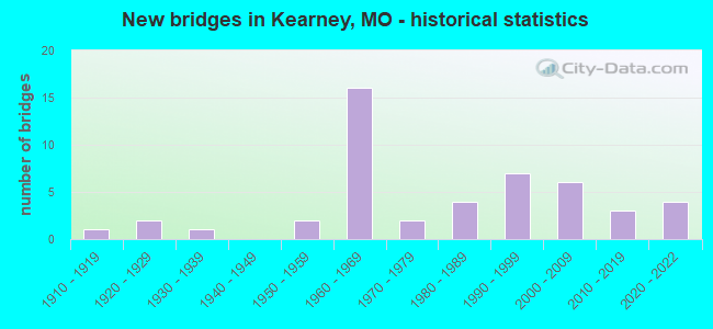
- New bridges - historical statistics
- 11910-1919
- 21920-1929
- 11930-1939
- 21950-1959
- 161960-1969
- 21970-1979
- 41980-1989
- 71990-1999
- 62000-2009
- 32010-2019
- 42020-2022
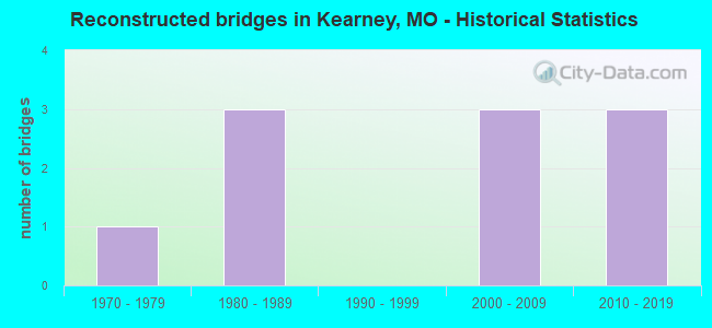
- Reconstructed bridges - Historical Statistics
- 11970-1979
- 31980-1989
- 01990-1999
- 32000-2009
- 32010-2019
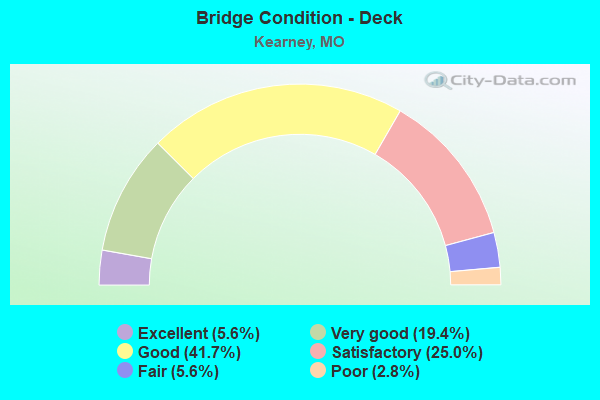
- Bridge Condition - Deck
- 5.6%Excellent
- 19.4%Very good
- 41.7%Good
- 25.0%Satisfactory
- 5.6%Fair
- 2.8%Poor
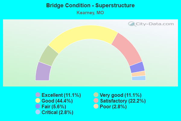
- Bridge Condition - Superstructure
- 11.1%Excellent
- 11.1%Very good
- 44.4%Good
- 22.2%Satisfactory
- 5.6%Fair
- 2.8%Poor
- 2.8%Critical
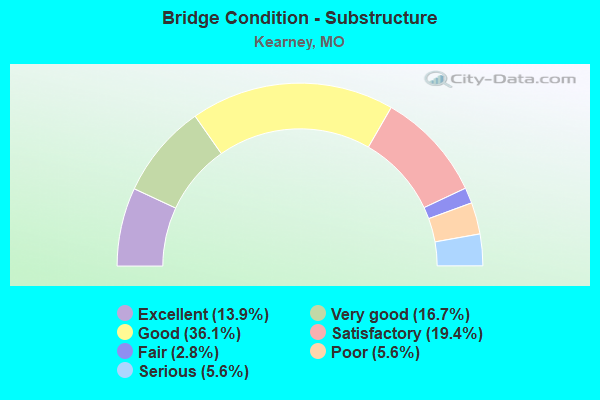
- Bridge Condition - Substructure
- 13.9%Excellent
- 16.7%Very good
- 36.1%Good
- 19.4%Satisfactory
- 2.8%Fair
- 5.6%Poor
- 5.6%Serious
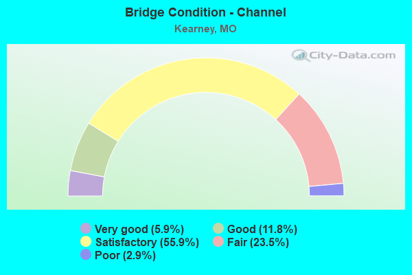
- Bridge Condition - Channel
- 5.9%Very good
- 11.8%Good
- 55.9%Satisfactory
- 23.5%Fair
- 2.9%Poor
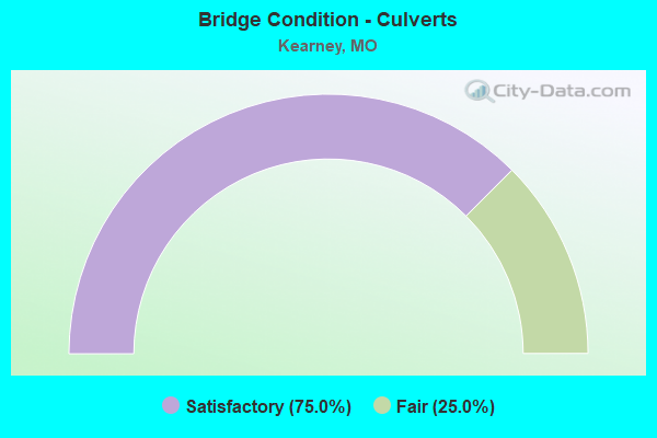
- Bridge Condition - Culverts
- 75.0%Satisfactory
- 25.0%Fair
Find on map >> Show street view
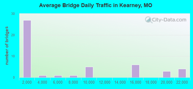
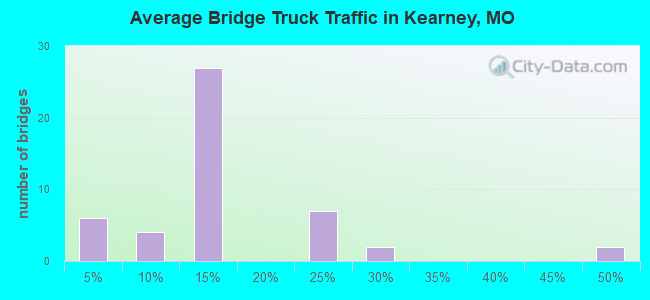
Structure Number: 1098, Location: S 27 T 53 N R 31 W (Lat: 39.367847, Lng: -94.372181), Route carried "under" structure: State highway 92, Year Built: 1965, Structure Length: 0. m, Average Daily Traffic: 14,935 (year 2021), Truck Traffic: 4%, Features Intersected: MO 92, Facility Carried by Structure: IS 35 N
Minimum Vertical Clearance: 4.52m (14.83ft), Kilometerpoint: 51.423, Lanes on structure: 2, Lanes under structure: 7, Material/Design: Steel continuous, Design/Construction: Stringer/Multi-beam, Length of Maximum Span: 23.8m (78.1ft)
Find on map >> Show street view
Structure Number: 1133, Location: S 27 T 53 N R 31 W (Lat: 39.380336, Lng: -94.365781), Route carried "under" structure: State highway 33, Year Built: 1965, Structure Length: 0. m, Average Daily Traffic: 8,936 (year 2021), Truck Traffic: 3%, Features Intersected: MO 33, Facility Carried by Structure: IS 35 S
Minimum Vertical Clearance: 6.55m (21.49ft), Kilometerpoint: 69.556, Lanes on structure: 2, Lanes under structure: 2, Material/Design: Steel continuous, Design/Construction: Stringer/Multi-beam, Length of Maximum Span: 26.2m (86.0ft)
Find on map >> Show street view
Structure Number: 1134, Location: S 27 T 53 N R 31 W (Lat: 39.380200, Lng: -94.365494), Route carried "under" structure: State highway 33, Year Built: 1965, Structure Length: 0. m, Average Daily Traffic: 8,936 (year 2021), Truck Traffic: 3%, Features Intersected: MO 33, Facility Carried by Structure: IS 35 N
Minimum Vertical Clearance: 6.73m (22.08ft), Kilometerpoint: 69.585, Lanes on structure: 2, Lanes under structure: 2, Material/Design: Steel continuous, Design/Construction: Stringer/Multi-beam, Length of Maximum Span: 26.2m (86.0ft)
Find on map >> Show street view
Structure Number: 36707, Location: S 33 T 53 N R 31 W (Lat: 39.353281, Lng: -94.380081), Route carried "under" structure: Interstate 35, Year Built: 2022, Structure Length: 0. m, Average Daily Traffic: 18,521 (year 2021), Truck Traffic: 23%, Features Intersected: IS 35, Facility Carried by Structure: 19TH ST E
Minimum Vertical Clearance: 5.13m (16.83ft), Kilometerpoint: 143.338, Lanes on structure: 4, Lanes under structure: 2, Material/Design: Prestressed concrete continuous, Design/Construction: Tee Beam, Length of Maximum Span: 28.4m (93.2ft)
Find on map >> Show street view
Structure Number: 36707, Location: S 33 T 53 N R 31 W (Lat: 39.353281, Lng: -94.380081), Route carried "under" structure: Interstate 35, Year Built: 2022, Structure Length: 0. m, Average Daily Traffic: 20,209 (year 2021), Truck Traffic: 21%, Features Intersected: IS 35, Facility Carried by Structure: 19TH ST E
Minimum Vertical Clearance: 5.11m (16.77ft), Kilometerpoint: 40.824, Lanes on structure: 4, Lanes under structure: 2, Material/Design: Prestressed concrete continuous, Design/Construction: Tee Beam, Length of Maximum Span: 28.4m (93.2ft)
Find on map >> Show street view
Structure Number: 8386, Location: S 16 T 52 N R 31 W (Lat: 39.324358, Lng: -94.395758), Route carried "under" structure: Interstate 35, Year Built: 1965, Structure Length: 0. m, Average Daily Traffic: 18,521 (year 2021), Truck Traffic: 23%, Features Intersected: IS 35, Facility Carried by Structure: 128TH ST E
Minimum Vertical Clearance: 4.93m (16.17ft), Kilometerpoint: 146.814, Lanes on structure: 2, Lanes under structure: 2, Material/Design: Steel continuous, Design/Construction: Stringer/Multi-beam, Length of Maximum Span: 21.6m (70.9ft)
Find on map >> Show street view
Structure Number: 8386, Location: S 16 T 52 N R 31 W (Lat: 39.324358, Lng: -94.395758), Route carried "under" structure: Interstate 35, Year Built: 1965, Structure Length: 0. m, Average Daily Traffic: 20,209 (year 2021), Truck Traffic: 21%, Features Intersected: IS 35, Facility Carried by Structure: 128TH ST E
Minimum Vertical Clearance: 4.95m (16.24ft), Kilometerpoint: 37.347, Lanes on structure: 2, Lanes under structure: 2, Material/Design: Steel continuous, Design/Construction: Stringer/Multi-beam, Length of Maximum Span: 21.6m (70.9ft)