Bridge Statistics for Kennewick, Washington (WA)
Condition, Traffic, Stress, Structural Evaluation, Project Costs
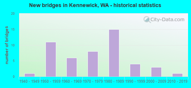
- New bridges - historical statistics
- 11940-1949
- 111950-1959
- 61960-1969
- 81970-1979
- 151980-1989
- 41990-1999
- 32000-2009
- 12010-2019
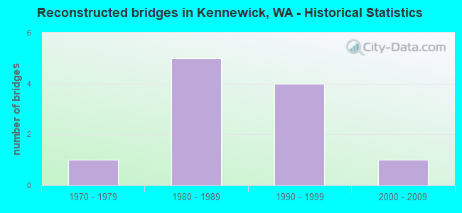
- Reconstructed bridges - Historical Statistics
- 11970-1979
- 51980-1989
- 41990-1999
- 12000-2009
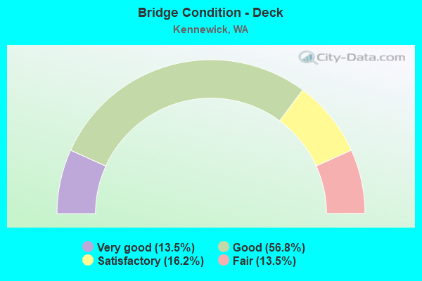
- Bridge Condition - Deck
- 13.5%Very good
- 56.8%Good
- 16.2%Satisfactory
- 13.5%Fair
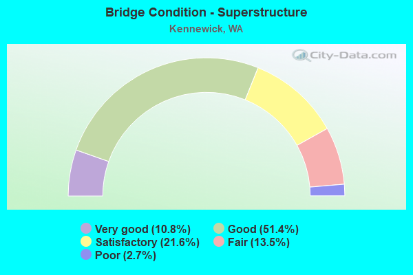
- Bridge Condition - Superstructure
- 10.8%Very good
- 51.4%Good
- 21.6%Satisfactory
- 13.5%Fair
- 2.7%Poor
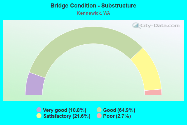
- Bridge Condition - Substructure
- 10.8%Very good
- 64.9%Good
- 21.6%Satisfactory
- 2.7%Poor
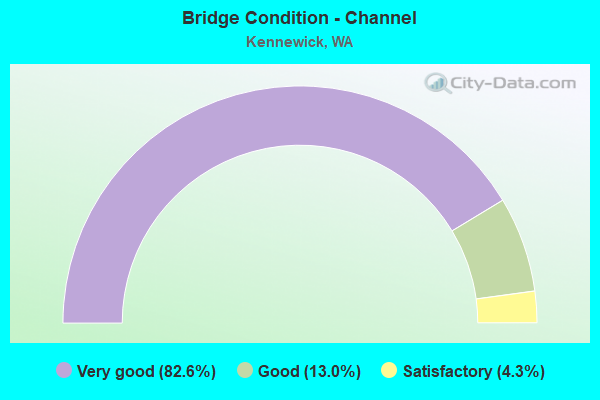
- Bridge Condition - Channel
- 82.6%Very good
- 13.0%Good
- 4.3%Satisfactory
Find on map >> Show street view
Structure Number: 88238, Location: .05 N. JCT CLEARWATER AVE (Lat: 46.210556, Lng: -119.225556), Route carried "on" structure: City street 610, Year Built: 2004, Status: Open, Structure Length: 2.47m (8.10ft), Average Daily Traffic: 29,404 (year 2018), Truck Traffic: 10%, Average Future Daily Traffic: 47,046 (year 2038), Design Load: HS 25 or greater, Features Intersected: BNSF RR, Facility Carried by Structure: Columbia Ctr. Blvd
Minimum Vertical Clearance: 30+ m (98+ ft), Kilometerpoint: 11.265, Lanes on structure: 6, Base Highway Network: Yes, Owner: City or Municipal Highway Agency, Approaching Roadway Width: 25.6m (84.0ft), Material/Design: Prestressed concrete, Design/Construction: Stringer/Multi-beam, Number Of Spans In Main Unit: 1, Length of Maximum Span: 23.5m (77.1ft), Curb or Sidewalk Widths: Left: 1.7m (5.6ft), Right: 1.7m (5.6ft), Curb-To-Curb Width: 25.6m (84.0ft), Out-to-Out Width: 29.8m (97.8ft)
Condition: Deck: Satisfactory, Superstructure: Satisfactory, Substructure: Good, Operating Rating: 59.9 metric tons, Method Used To Determine Operating Rating: Load and Resistance Factor Rating (LRFR) rating reported by rating factor(RF) method using HL-93 loadings, Inventory Rating: 46.3 metric tons, Method Used To Determine Inventory Rating: Load and Resistance Factor Rating (LRFR) rating reported by rating factor(RF) method using HL-93 loadings, Structural Evaluation: Equal to present minimum criteria, Deck Geometry: Somewhat better than minimum adequacy, Underclear: Superior to present desirable criteria, Approach Roadway Alignment: Equal to present desirable criteria, Designated Inspection Frequency: Every 24 months, Inspection Date: November 2020, Deck Structure Type: Concrete Cast-file-Place, Wearing Surface/Protective System: Wearing Surface: Monolithic Concrete, Deck Protection: Epoxy Coated Reinforcing
Find on map >> Show street view
Structure Number: 88706, Location: .04 S JCT 1ST AVE (Lat: 46.206856, Lng: -119.122983), Route carried "on" structure: City street 610, Year Built: 2014, Status: Open, Structure Length: 1.40m (4.59ft), Average Daily Traffic: 5,000 (year 2016), Truck Traffic: 1%, Average Future Daily Traffic: 8,000 (year 2036), Design Load: HL 93, Features Intersected: CID CANAL, Facility Carried by Structure: DAYTON STREET
Minimum Vertical Clearance: 30+ m (98+ ft), Kilometerpoint: 0.001, Lanes on structure: 3, Owner: City or Municipal Highway Agency, Approaching Roadway Width: 15.5m (50.9ft), Skew: 3 degrees, Material/Design: Prestressed concrete, Design/Construction: Slab, Number Of Spans In Main Unit: 1, Length of Maximum Span: 13.7m (44.9ft), Curb or Sidewalk Widths: Left: 1.6m (5.2ft), Right: 1.6m (5.2ft), Curb-To-Curb Width: 15.5m (50.9ft), Out-to-Out Width: 19.5m (64.0ft)
Condition: Deck: Good, Superstructure: Very good, Substructure: Good, Channel: Very good, Operating Rating: 65.1 metric tons, Method Used To Determine Operating Rating: Load and Resistance Factor Rating (LRFR) rating reported by rating factor(RF) method using HL-93 loadings, Inventory Rating: 35.3 metric tons, Method Used To Determine Inventory Rating: Load and Resistance Factor Rating (LRFR) rating reported by rating factor(RF) method using HL-93 loadings, Structural Evaluation: Better than present minimum criteria, Deck Geometry: Equal to present minimum criteria, Waterway Adequacy: Equal to present desirable criteria, Approach Roadway Alignment: Equal to present desirable criteria, Designated Inspection Frequency: Every 24 months, Inspection Date: November 2020, Deck Structure Type: Concrete Cast-file-Place, Wearing Surface/Protective System: Wearing Surface: Monolithic Concrete, Deck Protection: Epoxy Coated Reinforcing
Find on map >> Show street view
Structure Number: 4218A, Location: 0.2 W JCT US 395 (Lat: 46.217250, Lng: -119.140861), Route carried "under" structure: Ramp US 395, Year Built: 1952, Structure Length: 0. m, Average Daily Traffic: 10,539 (year 2019), Truck Traffic: 5%, Features Intersected: US 395-SR 240 RAMPS, Facility Carried by Structure: SR 240 WB
Minimum Vertical Clearance: 5.03m (16.50ft), Kilometerpoint: 0.595, Lanes on structure: 2, Lanes under structure: 2, Material/Design: Concrete continuous, Design/Construction: Tee Beam, Length of Maximum Span: 21.6m (70.9ft)
Find on map >> Show street view
Structure Number: 4596A, Location: 6.7 E JCT I-182 (Lat: 46.216861, Lng: -119.138000), Route carried "under" structure: State highway 240, Year Built: 1954, Structure Length: 0. m, Average Daily Traffic: 12,594 (year 2019), Truck Traffic: 3%, Features Intersected: SR 240 / W COLUMBIA DR, Facility Carried by Structure: US 395
Minimum Vertical Clearance: 4.90m (16.08ft), Kilometerpoint: 69.475, Lanes on structure: 3, Lanes under structure: 4, Material/Design: Steel, Design/Construction: Stringer/Multi-beam, Length of Maximum Span: 20.7m (67.9ft)
Find on map >> Show street view
Structure Number: 12607A, Location: JCT I-82 (Lat: 46.142417, Lng: -119.202250), Route carried "under" structure: State highway 397, Year Built: 1984, Structure Length: 0. m, Average Daily Traffic: 1,855 (year 2019), Truck Traffic: 11%, Features Intersected: SR 397/LOCUST GROVE RD, Facility Carried by Structure: I-82
Minimum Vertical Clearance: 4.93m (16.17ft), Kilometerpoint: 0.001, Lanes on structure: 2, Lanes under structure: 2, Material/Design: Prestressed concrete, Design/Construction: Stringer/Multi-beam, Length of Maximum Span: 36.6m (120.1ft)
Find on map >> Show street view
Structure Number: 12607B, Location: JCT I-82 (Lat: 46.142139, Lng: -119.201833), Route carried "under" structure: State highway 397, Year Built: 1984, Structure Length: 0. m, Average Daily Traffic: 1,855 (year 2019), Truck Traffic: 11%, Features Intersected: SR 397/LOCUST GROVE RD, Facility Carried by Structure: I-82
Minimum Vertical Clearance: 5.11m (16.77ft), Kilometerpoint: 0.032, Lanes on structure: 2, Lanes under structure: 2, Material/Design: Prestressed concrete, Design/Construction: Stringer/Multi-beam, Length of Maximum Span: 36.6m (120.1ft)
Find on map >> Show street view
Structure Number: 12610A, Location: 10.3 E JCT I-182 (Lat: 46.165367, Lng: -119.202928), Route carried "under" structure: Interstate 82, Year Built: 1984, Structure Length: 0. m, Average Daily Traffic: 16,264 (year 2019), Truck Traffic: 21%, Features Intersected: I-82, Facility Carried by Structure: US 395
Minimum Vertical Clearance: 6.76m (22.18ft), Kilometerpoint: 181.518, Lanes on structure: 3, Lanes under structure: 4, Material/Design: Prestressed concrete continuous, Design/Construction: Box Beam or Girders - Multiple, Length of Maximum Span: 40.2m (131.9ft)
Find on map >> Show street view
Structure Number: 12610B, Location: 7.1 E JCT I-182 (Lat: 46.189083, Lng: -119.257778), Route carried "under" structure: Interstate 82, Year Built: 1985, Structure Length: 0. m, Average Daily Traffic: 13,686 (year 2019), Truck Traffic: 21%, Features Intersected: I-82, Facility Carried by Structure: KID CANAL AQUADUCT
Minimum Vertical Clearance: 6.83m (22.41ft), Kilometerpoint: 176.352, Lanes under structure: 4, Material/Design: Prestressed concrete continuous, Design/Construction: Box Beam or Girders - Multiple, Length of Maximum Span: 37.2m (122.0ft)
Find on map >> Show street view
Structure Number: 12610C, Location: 7.2 E JCT I-182 (Lat: 46.187889, Lng: -119.256333), Route carried "under" structure: Interstate 82, Year Built: 1984, Structure Length: 0. m, Average Daily Traffic: 16,264 (year 2019), Truck Traffic: 21%, Features Intersected: I-82, Facility Carried by Structure: CLODFELTER ROAD
Minimum Vertical Clearance: 9.86m (32.35ft), Kilometerpoint: 176.529, Lanes on structure: 2, Lanes under structure: 4, Material/Design: Prestressed concrete continuous, Design/Construction: Box Beam or Girders - Multiple, Length of Maximum Span: 41.5m (136.2ft)
Find on map >> Show street view
Structure Number: 12610D, Location: 9.9 E JCT I-182 (Lat: 46.169833, Lng: -119.206417), Route carried "under" structure: Interstate 82, Year Built: 1984, Structure Length: 0. m, Average Daily Traffic: 16,264 (year 2019), Truck Traffic: 21%, Features Intersected: I-82, Facility Carried by Structure: CHRISTENSEN ROAD
Minimum Vertical Clearance: 8.23m (27.00ft), Kilometerpoint: 180.971, Lanes on structure: 2, Lanes under structure: 4, Material/Design: Prestressed concrete continuous, Design/Construction: Box Beam or Girders - Multiple, Length of Maximum Span: 50.6m (166.0ft)
Find on map >> Show street view
Structure Number: 17619A, Location: JCT US 395 (Lat: 46.218806, Lng: -119.138306), Route carried "under" structure: State highway 240, Year Built: 2009, Structure Length: 0. m, Average Daily Traffic: 11,816 (year 2019), Truck Traffic: 8%, Features Intersected: SR 240 E-N RAMP, Facility Carried by Structure: SB US 395
Minimum Vertical Clearance: 5.23m (17.16ft), Kilometerpoint: 0.628, Lanes on structure: 3, Lanes under structure: 1, Material/Design: Prestressed concrete, Design/Construction: Stringer/Multi-beam, Length of Maximum Span: 46.3m (151.9ft)
Find on map >> Show street view
Structure Number: 200063, Location: 8.5 E JCT SR 224 (Lat: 46.228417, Lng: -119.191167), Route carried "under" structure: State highway 240, Year Built: 1996, Structure Length: 0. m, Average Daily Traffic: 33,423 (year 2019), Truck Traffic: 3%, Features Intersected: SR 240, Facility Carried by Structure: EDISON ST
Minimum Vertical Clearance: 5.69m (18.67ft), Kilometerpoint: 65.146, Lanes on structure: 4, Lanes under structure: 4, Material/Design: Prestressed concrete continuous, Design/Construction: Stringer/Multi-beam, Length of Maximum Span: 31.7m (104.0ft)
Find on map >> Show street view
Structure Number: 85899, Location: 17.7 N JCT I-82 (Lat: 46.208944, Lng: -119.107278), Route carried "under" structure: State highway 397, Year Built: 1960, Structure Length: 0. m, Average Daily Traffic: 18,901 (year 2019), Truck Traffic: 7%, Features Intersected: SR 397, Facility Carried by Structure: BNRR
Minimum Vertical Clearance: 4.60m (15.09ft), Kilometerpoint: 28.469, Lanes under structure: 4, Material/Design: Steel, Design/Construction: Stringer/Multi-beam, Length of Maximum Span: 12.2m (40.0ft)