Bridge Statistics for Kentwood, Michigan (MI)
Condition, Traffic, Stress, Structural Evaluation, Project Costs
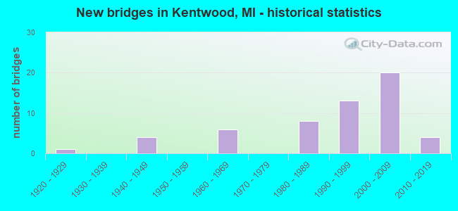
- New bridges - historical statistics
- 11920-1929
- 41940-1949
- 61960-1969
- 81980-1989
- 131990-1999
- 202000-2009
- 42010-2019
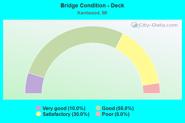
- Bridge Condition - Deck
- 10.0%Very good
- 55.0%Good
- 30.0%Satisfactory
- 5.0%Poor
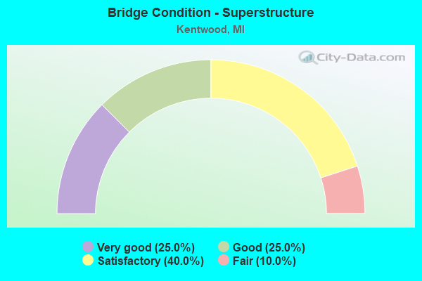
- Bridge Condition - Superstructure
- 25.0%Very good
- 25.0%Good
- 40.0%Satisfactory
- 10.0%Fair
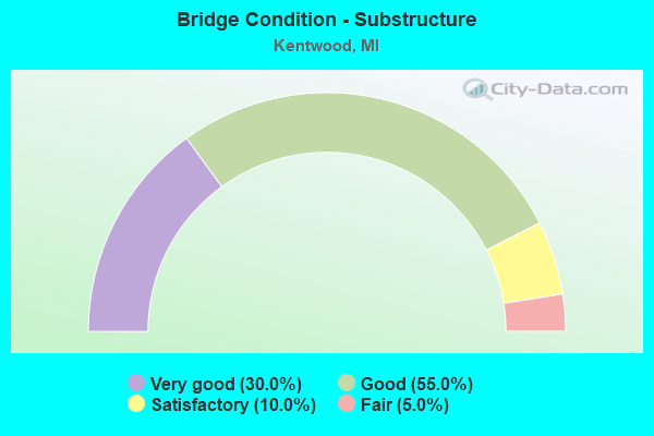
- Bridge Condition - Substructure
- 30.0%Very good
- 55.0%Good
- 10.0%Satisfactory
- 5.0%Fair
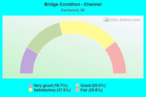
- Bridge Condition - Channel
- 16.7%Very good
- 25.0%Good
- 37.5%Satisfactory
- 20.8%Fair
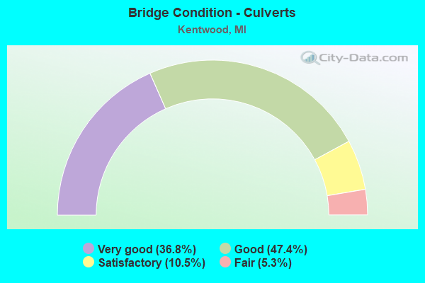
- Bridge Condition - Culverts
- 36.8%Very good
- 47.4%Good
- 10.5%Satisfactory
- 5.3%Fair
Find on map >> Show street view
Structure Number: 12814, Location: CALEDONIA TWP SEC 5&6 (Lat: 42.853014, Lng: -85.527783), Route carried "under" structure: County highway , Year Built: 1999, Structure Length: 0. m, Average Daily Traffic: 11,460 (year 2003), Truck Traffic: 13%, Features Intersected: KRAFT AVENUE, Facility Carried by Structure: M-6 EB
Minimum Vertical Clearance: 4.55m (14.93ft), Kilometerpoint: 1.815, Lanes on structure: 2, Lanes under structure: 2, Material/Design: Prestressed concrete, Design/Construction: Stringer/Multi-beam, Length of Maximum Span: 39.0m (128.0ft)
Find on map >> Show street view
Structure Number: 12815, Location: CASCADE TWP SEC 32 (Lat: 42.856597, Lng: -85.509978), Route carried "under" structure: State highway 6, Year Built: 1999, Structure Length: 0. m, Average Daily Traffic: 13,761 (year 2007), Truck Traffic: 13%, Features Intersected: M-6
Minimum Vertical Clearance: 6.12m (20.08ft), Kilometerpoint: 22.799, Lanes on structure: 2, Lanes under structure: 4, Material/Design: Steel continuous, Design/Construction: Stringer/Multi-beam, Length of Maximum Span: 53.5m (175.5ft)
Find on map >> Show street view
Structure Number: 12818, Location: CALDONIA TWP SEC 5&6 (Lat: 42.853433, Lng: -85.527786), Route carried "under" structure: County highway , Year Built: 1999, Structure Length: 0. m, Average Daily Traffic: 11,460 (year 2003), Truck Traffic: 13%, Features Intersected: KRAFT AVENUE, Facility Carried by Structure: M-6 WB
Minimum Vertical Clearance: 4.47m (14.67ft), Kilometerpoint: 1.862, Lanes on structure: 2, Lanes under structure: 2, Material/Design: Prestressed concrete, Design/Construction: Stringer/Multi-beam, Length of Maximum Span: 39.0m (128.0ft)
Find on map >> Show street view
Structure Number: 12929, Location: GAINES TWP SEC 1&2 (Lat: 42.846697, Lng: -85.565472), Route carried "under" structure: State highway 6, Year Built: 2001, Structure Length: 0. m, Average Daily Traffic: 40,180 (year 2007), Truck Traffic: 6%, Features Intersected: M-6, Facility Carried by Structure: EAST PARIS AVE
Minimum Vertical Clearance: 5.39m (17.68ft), Kilometerpoint: 18.117, Lanes on structure: 3, Lanes under structure: 4, Material/Design: Prestressed concrete, Design/Construction: Stringer/Multi-beam, Length of Maximum Span: 39.7m (130.2ft)
Find on map >> Show street view
Structure Number: 1293, Location: GAINES TWP SEC 1 (Lat: 42.849414, Lng: -85.545775), Route carried "under" structure: State highway 6, Year Built: 2000, Structure Length: 0. m, Average Daily Traffic: 40,180 (year 2007), Truck Traffic: 6%, Features Intersected: M-6, Facility Carried by Structure: PATTERSON AVENUE
Minimum Vertical Clearance: 6.12m (20.08ft), Kilometerpoint: 19.770, Lanes on structure: 2, Lanes under structure: 8, Material/Design: Steel continuous, Design/Construction: Stringer/Multi-beam, Length of Maximum Span: 56.8m (186.4ft)
Find on map >> Show street view
Structure Number: 13039, Location: GAINES TWP SEC 4-5 (Lat: 42.846978, Lng: -85.624728), Route carried "under" structure: County highway , Year Built: 2001, Structure Length: 0. m, Average Daily Traffic: 17,986 (year 1997), Truck Traffic: 3%, Features Intersected: KALAMAZOO AVE, Facility Carried by Structure: M-6 EB
Minimum Vertical Clearance: 4.90m (16.08ft), Kilometerpoint: 0.129, Lanes on structure: 2, Lanes under structure: 2, Material/Design: Steel, Design/Construction: Stringer/Multi-beam, Length of Maximum Span: 53.4m (175.2ft)
Find on map >> Show street view
Structure Number: 1304, Location: GAINES TWP SEC 4-5 (Lat: 42.847269, Lng: -85.624753), Route carried "under" structure: County highway , Year Built: 2001, Structure Length: 0. m, Average Daily Traffic: 17,986 (year 1997), Truck Traffic: 3%, Features Intersected: KALAMAZOO AVE, Facility Carried by Structure: M-6 WB
Minimum Vertical Clearance: 4.72m (15.49ft), Kilometerpoint: 0.089, Lanes on structure: 2, Lanes under structure: 8, Material/Design: Steel, Design/Construction: Stringer/Multi-beam, Length of Maximum Span: 53.4m (175.2ft)
Find on map >> Show street view
Structure Number: 13051, Location: GAINES TWP SEC 2 - 3 (Lat: 42.851103, Lng: -85.585264), Route carried "under" structure: County highway , Year Built: 2002, Structure Length: 0. m, Average Daily Traffic: 199 (year 2010), Truck Traffic: 3%, Features Intersected: HANNA LAKE RD, Facility Carried by Structure: M-6 WB
Minimum Vertical Clearance: 4.78m (15.68ft), Kilometerpoint: 1.110, Lanes on structure: 2, Lanes under structure: 2, Material/Design: Prestressed concrete, Design/Construction: Stringer/Multi-beam, Length of Maximum Span: 38.0m (124.7ft)
Find on map >> Show street view
Structure Number: 13052, Location: GAINES TWP SEC 2 - 3 (Lat: 42.850803, Lng: -85.585267), Route carried "under" structure: County highway , Year Built: 2002, Structure Length: 0. m, Average Daily Traffic: 199 (year 2010), Truck Traffic: 3%, Features Intersected: HANNA LAKE RD, Facility Carried by Structure: M-6 EB
Minimum Vertical Clearance: 4.75m (15.58ft), Kilometerpoint: 1.077, Lanes on structure: 2, Lanes under structure: 2, Material/Design: Prestressed concrete, Design/Construction: Stringer/Multi-beam, Length of Maximum Span: 38.0m (124.7ft)
Find on map >> Show street view
Structure Number: 1382, Location: 1 MI S OF M-21 (Lat: 42.946736, Lng: -85.567000), Route carried "under" structure: Interstate 96, Year Built: 2016, Structure Length: 0. m, Average Daily Traffic: 76,745 (year 2015), Truck Traffic: 7%, Features Intersected: I-96, Facility Carried by Structure: CASCADE RD EB (SCH
Minimum Vertical Clearance: 5.00m (16.40ft), Kilometerpoint: 0.000, Lanes on structure: 3, Lanes under structure: 4, Material/Design: Prestressed concrete, Design/Construction: Stringer/Multi-beam, Length of Maximum Span: 63.3m (207.7ft)
Find on map >> Show street view
Structure Number: 13821, Location: 1 MI N OF M-21 (Lat: 42.946861, Lng: -85.567000), Route carried "under" structure: Interstate 96, Year Built: 2016, Structure Length: 0. m, Average Daily Traffic: 76,745 (year 2015), Truck Traffic: 7%, Features Intersected: I-96, Facility Carried by Structure: CASCADE RD WB (SCH
Minimum Vertical Clearance: 5.16m (16.93ft), Kilometerpoint: 0.000, Lanes on structure: 3, Lanes under structure: 4, Material/Design: Prestressed concrete, Design/Construction: Stringer/Multi-beam, Length of Maximum Span: 63.3m (207.7ft)