Bridge Statistics for Kerrville, Texas (TX)
Condition, Traffic, Stress, Structural Evaluation, Project Costs
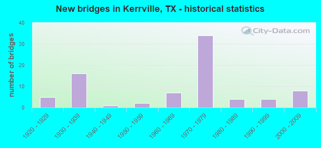
- New bridges - historical statistics
- 51920-1929
- 161930-1939
- 11940-1949
- 21950-1959
- 71960-1969
- 341970-1979
- 41980-1989
- 41990-1999
- 82000-2009
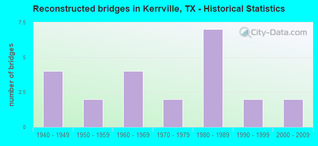
- Reconstructed bridges - Historical Statistics
- 41940-1949
- 21950-1959
- 41960-1969
- 21970-1979
- 71980-1989
- 21990-1999
- 22000-2009
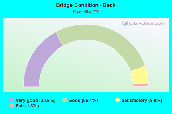
- Bridge Condition - Deck
- 33.9%Very good
- 55.4%Good
- 8.9%Satisfactory
- 1.8%Fair
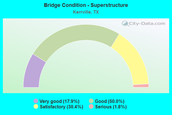
- Bridge Condition - Superstructure
- 17.9%Very good
- 50.0%Good
- 30.4%Satisfactory
- 1.8%Serious
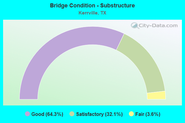
- Bridge Condition - Substructure
- 64.3%Good
- 32.1%Satisfactory
- 3.6%Fair
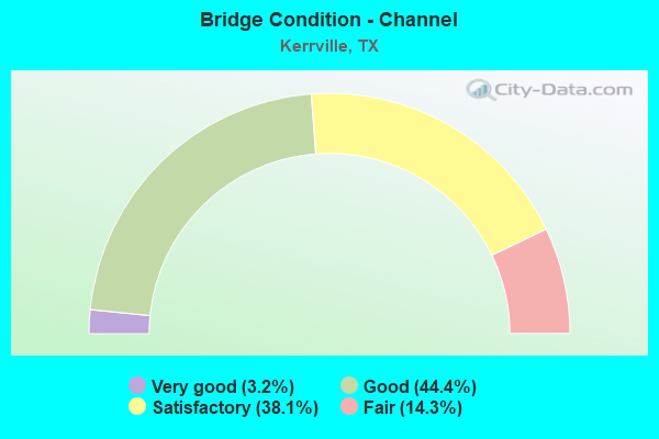
- Bridge Condition - Channel
- 3.2%Very good
- 44.4%Good
- 38.1%Satisfactory
- 14.3%Fair
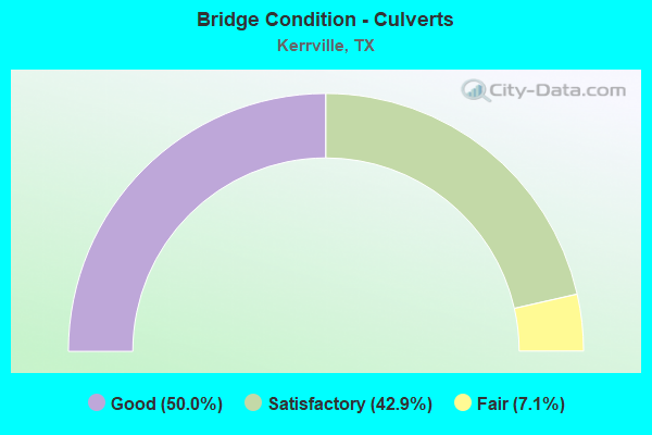
- Bridge Condition - Culverts
- 50.0%Good
- 42.9%Satisfactory
- 7.1%Fair
Find on map >> Show street view
Structure Number: 151330060901001, Location: 1.7 MI SE OF SH 16 (Lat: 30.016964, Lng: -99.126656), Route carried "on" structure: State highway 173, Year Built: 1937, Year Reconstructed: 1986, Status: Open, Structure Length: 4.30m (14.11ft), Average Daily Traffic: 12,699 (year 2020), Truck Traffic: 7%, Average Future Daily Traffic: 14,350 (year 2033), Features Intersected: CAMP MEETING CREEK
Minimum Vertical Clearance: 30+ m (98+ ft), Kilometerpoint: 2.557, Lanes on structure: 4, Owner: State Highway Agency, Approaching Roadway Width: 15.9m (52.2ft), Skew: 3 degrees, Material/Design: Steel, Design/Construction: Stringer/Multi-beam, Number Of Spans In Main Unit: 4, Length of Maximum Span: 10.7m (35.1ft), Curb-To-Curb Width: 15.9m (52.2ft), Out-to-Out Width: 16.5m (54.1ft)
Condition: Deck: Good, Superstructure: Satisfactory, Substructure: Satisfactory, Channel: Satisfactory, Operating Rating: 32.7 metric tons, Method Used To Determine Operating Rating: Field evaluation and documented engineering judgment, Inventory Rating: 24.5 metric tons, Method Used To Determine Inventory Rating: Field evaluation and documented engineering judgment, Structural Evaluation: Equal to present minimum criteria, Deck Geometry: Meets minimum limits, Waterway Adequacy: Superior to present desirable criteria, Approach Roadway Alignment: Equal to present desirable criteria, Designated Inspection Frequency: Every 24 months, Inspection Date: July 2020, Deck Structure Type: Concrete Cast-file-Place, Wearing Surface/Protective System: Wearing Surface: Bituminous
Find on map >> Show street view
Structure Number: 151330085501014, Location: 2.0 MI S OF SH 27 (Lat: 29.925536, Lng: -99.046953), Route carried "on" structure: State highway 480, Year Built: 1973, Status: Open, Structure Length: 7.92m (25.98ft), Average Daily Traffic: 1,432 (year 2020), Truck Traffic: 4%, Average Future Daily Traffic: 1,980 (year 2033), Design Load: HS 20, Features Intersected: VERDE CREEK
Minimum Vertical Clearance: 30+ m (98+ ft), Kilometerpoint: 4.971, Lanes on structure: 2, Owner: State Highway Agency, Approaching Roadway Width: 7.9m (25.9ft), Skew: 3 degrees, Material/Design: Prestressed concrete, Design/Construction: Stringer/Multi-beam, Number Of Spans In Main Unit: 2, Number Of Approach Spans: 2, Length of Maximum Span: 24.4m (80.1ft), Curb-To-Curb Width: 10.4m (34.1ft), Out-to-Out Width: 11.0m (36.1ft)
Condition: Deck: Very good, Superstructure: Good, Substructure: Satisfactory, Channel: Fair, Operating Rating: 54.4 metric tons, Method Used To Determine Operating Rating: Assigned rating based on Load Factor Design (LFD) reported in metric tons, Inventory Rating: 32.7 metric tons, Method Used To Determine Inventory Rating: Assigned rating based on Load Factor Design (LFD) reported in metric tons, Structural Evaluation: Equal to present minimum criteria, Deck Geometry: Equal to present minimum criteria, Waterway Adequacy: Equal to present minimum criteria, Approach Roadway Alignment: Better than present minimum criteria, Designated Inspection Frequency: Every 24 months, Inspection Date: July 2020, Deck Structure Type: Concrete Cast-file-Place, Wearing Surface/Protective System: Wearing Surface: Bituminous
Find on map >> Show street view
Structure Number: 151330085501015, Location: 3.1 MI NE OF SH 173 (Lat: 29.917506, Lng: -99.056689), Route carried "on" structure: State highway 480, Year Built: 1973, Status: Open, Structure Length: 6.10m (20.01ft), Average Daily Traffic: 1,432 (year 2020), Truck Traffic: 4%, Average Future Daily Traffic: 1,980 (year 2033), Design Load: HS 20, Features Intersected: VERDE CREEK
Minimum Vertical Clearance: 30+ m (98+ ft), Kilometerpoint: 6.299, Lanes on structure: 2, Owner: State Highway Agency, Approaching Roadway Width: 7.9m (25.9ft), Material/Design: Prestressed concrete, Design/Construction: Stringer/Multi-beam, Number Of Spans In Main Unit: 2, Number Of Approach Spans: 1, Length of Maximum Span: 24.4m (80.1ft), Curb-To-Curb Width: 10.4m (34.1ft), Out-to-Out Width: 11.0m (36.1ft)
Condition: Deck: Very good, Superstructure: Good, Substructure: Good, Channel: Satisfactory, Operating Rating: 54.4 metric tons, Method Used To Determine Operating Rating: Assigned rating based on Load Factor Design (LFD) reported in metric tons, Inventory Rating: 32.7 metric tons, Method Used To Determine Inventory Rating: Assigned rating based on Load Factor Design (LFD) reported in metric tons, Structural Evaluation: Better than present minimum criteria, Deck Geometry: Equal to present minimum criteria, Waterway Adequacy: Equal to present minimum criteria, Approach Roadway Alignment: Equal to present desirable criteria, Designated Inspection Frequency: Every 24 months, Inspection Date: July 2020, Deck Structure Type: Concrete Cast-file-Place, Wearing Surface/Protective System: Wearing Surface: Bituminous
Find on map >> Show street view
Structure Number: 151330085501016, Location: 3.0 MI NE OF SH 173 (Lat: 29.913914, Lng: -99.066697), Route carried "on" structure: State highway 480, Year Built: 1973, Status: Open, Structure Length: 6.40m (21.00ft), Average Daily Traffic: 1,432 (year 2020), Truck Traffic: 4%, Average Future Daily Traffic: 1,980 (year 2033), Design Load: HS 20, Features Intersected: VERDE CREEK
Minimum Vertical Clearance: 30+ m (98+ ft), Kilometerpoint: 7.417, Lanes on structure: 2, Owner: State Highway Agency, Approaching Roadway Width: 7.9m (25.9ft), Skew: 2 degrees, Material/Design: Prestressed concrete, Design/Construction: Stringer/Multi-beam, Number Of Spans In Main Unit: 1, Number Of Approach Spans: 2, Length of Maximum Span: 24.4m (80.1ft), Curb-To-Curb Width: 10.4m (34.1ft), Out-to-Out Width: 11.0m (36.1ft)
Condition: Deck: Very good, Superstructure: Very good, Substructure: Good, Channel: Good, Operating Rating: 54.4 metric tons, Method Used To Determine Operating Rating: Assigned rating based on Load Factor Design (LFD) reported in metric tons, Inventory Rating: 32.7 metric tons, Method Used To Determine Inventory Rating: Assigned rating based on Load Factor Design (LFD) reported in metric tons, Structural Evaluation: Better than present minimum criteria, Deck Geometry: Equal to present minimum criteria, Waterway Adequacy: Equal to present minimum criteria, Approach Roadway Alignment: Equal to present desirable criteria, Designated Inspection Frequency: Every 24 months, Inspection Date: July 2020, Deck Structure Type: Concrete Cast-file-Place, Wearing Surface/Protective System: Wearing Surface: Bituminous
Find on map >> Show street view
Structure Number: 151330085501017, Location: 0.2 MI S OF SH 27 (Lat: 29.946006, Lng: -99.037417), Route carried "on" structure: State highway 480, Year Built: 1979, Status: Open, Structure Length: 24.99m (81.99ft), Average Daily Traffic: 3,315 (year 2020), Truck Traffic: 15%, Average Future Daily Traffic: 4,930 (year 2033), Design Load: HS 20, Features Intersected: GUADALUPE RIVER
Minimum Vertical Clearance: 30+ m (98+ ft), Kilometerpoint: 2.037, Lanes on structure: 2, Owner: State Highway Agency, Approaching Roadway Width: 12.2m (40.0ft), Material/Design: Prestressed concrete, Design/Construction: Stringer/Multi-beam, Number Of Spans In Main Unit: 9, Length of Maximum Span: 28.3m (92.8ft), Curb or Sidewalk Widths: Left: 0.0m, Right: 1.2m (3.9ft), Curb-To-Curb Width: 12.2m (40.0ft), Out-to-Out Width: 14.0m (45.9ft)
Condition: Deck: Good, Superstructure: Satisfactory, Substructure: Good, Channel: Satisfactory, Operating Rating: 54.4 metric tons, Method Used To Determine Operating Rating: Assigned rating based on Load Factor Design (LFD) reported in metric tons, Inventory Rating: 32.7 metric tons, Method Used To Determine Inventory Rating: Assigned rating based on Load Factor Design (LFD) reported in metric tons, Structural Evaluation: Equal to present minimum criteria, Deck Geometry: Equal to present minimum criteria, Waterway Adequacy: Equal to present minimum criteria, Approach Roadway Alignment: Equal to present desirable criteria, Designated Inspection Frequency: Every 24 months, Inspection Date: July 2020, Deck Structure Type: Concrete Cast-file-Place, Wearing Surface/Protective System: Wearing Surface: Bituminous
Find on map >> Show street view
Structure Number: 151330085602001, Location: 1.8 MI E OF SH 16 (Lat: 29.968364, Lng: -99.164411), Route carried "on" structure: State highway 2771, Year Built: 1965, Status: Open, Structure Length: 0.70m (2.30ft), Average Daily Traffic: 761 (year 2020), Truck Traffic: 23%, Average Future Daily Traffic: 870 (year 2033), Design Load: H 20, Features Intersected: WEST CREEK
Minimum Vertical Clearance: 30+ m (98+ ft), Kilometerpoint: 2.916, Lanes on structure: 2, Owner: State Highway Agency, Approaching Roadway Width: 8.5m (27.9ft), Skew: 1 degrees, Material/Design: Concrete, Design/Construction: Culvert, Number Of Spans In Main Unit: 2, Length of Maximum Span: 3.0m (9.8ft), Curb-To-Curb Width: 8.5m (27.9ft), Out-to-Out Width: 13.7m (44.9ft)
Condition: Channel: Satisfactory, Culverts: Good, Operating Rating: 39.9 metric tons, Method Used To Determine Operating Rating: Load Factor (LF), Inventory Rating: 23.6 metric tons, Method Used To Determine Inventory Rating: Load Factor (LF), Structural Evaluation: Equal to present minimum criteria, Deck Geometry: Somewhat better than minimum adequacy, Waterway Adequacy: Better than present minimum criteria, Approach Roadway Alignment: Equal to present desirable criteria, Designated Inspection Frequency: Every 24 months, Inspection Date: July 2020, Deck Structure Type: Concrete Cast-file-Place, Wearing Surface/Protective System: Wearing Surface: Bituminous
Find on map >> Show street view
Structure Number: 151330113502005, Location: 1.0 MI N OF SH 27 (Lat: 30.069778, Lng: -99.154756), Route carried "on" structure: State highway 783, Year Built: 1970, Status: Open, Structure Length: 0.85m (2.79ft), Average Daily Traffic: 9,496 (year 2020), Truck Traffic: 28%, Average Future Daily Traffic: 10,150 (year 2033), Design Load: HS 20, Features Intersected: DRAW
Minimum Vertical Clearance: 30+ m (98+ ft), Kilometerpoint: 9.543, Lanes on structure: 4, Owner: State Highway Agency, Approaching Roadway Width: 14.6m (47.9ft), Skew: 4 degrees, Material/Design: Concrete, Design/Construction: Culvert, Number Of Spans In Main Unit: 3, Length of Maximum Span: 1.8m (5.9ft), Curb-To-Curb Width: 14.7m (48.2ft), Out-to-Out Width: 16.8m (55.1ft)
Condition: Channel: Good, Culverts: Good, Operating Rating: 39.9 metric tons, Method Used To Determine Operating Rating: Load Factor (LF), Inventory Rating: 23.6 metric tons, Method Used To Determine Inventory Rating: Load Factor (LF), Structural Evaluation: Somewhat better than minimum adequacy, Deck Geometry: High priority of replacement, Waterway Adequacy: Equal to present minimum criteria, Approach Roadway Alignment: Equal to present desirable criteria, Length Of Structure Improvement: 0.85m (2.79ft), Designated Inspection Frequency: Every 24 months, Inspection Date: July 2020, Bridge Improvement Cost: $3,000, Roadway Improvement Cost: $1,000, Total Project Cost: $4,000, Deck Structure Type: Concrete Cast-file-Place, Wearing Surface/Protective System: Wearing Surface: Bituminous
Find on map >> Show street view
Structure Number: 151330113502008, Location: 2.0 MI N OF IH 10 (Lat: 30.115583, Lng: -99.154803), Route carried "on" structure: State highway 783, Year Built: 1991, Status: Open, Structure Length: 3.81m (12.50ft), Average Daily Traffic: 3,441 (year 2020), Truck Traffic: 31%, Average Future Daily Traffic: 4,020 (year 2033), Design Load: HS 20, Features Intersected: TOWN CREEK
Minimum Vertical Clearance: 30+ m (98+ ft), Kilometerpoint: 3.945, Lanes on structure: 2, Owner: State Highway Agency, Approaching Roadway Width: 12.2m (40.0ft), Material/Design: Concrete, Design/Construction: Slab, Number Of Spans In Main Unit: 5, Length of Maximum Span: 7.6m (24.9ft), Curb-To-Curb Width: 12.2m (40.0ft), Out-to-Out Width: 12.8m (42.0ft)
Condition: Deck: Good, Superstructure: Good, Substructure: Good, Channel: Good, Operating Rating: 54.4 metric tons, Method Used To Determine Operating Rating: Assigned rating based on Load Factor Design (LFD) reported in metric tons, Inventory Rating: 32.7 metric tons, Method Used To Determine Inventory Rating: Assigned rating based on Load Factor Design (LFD) reported in metric tons, Structural Evaluation: Better than present minimum criteria, Deck Geometry: Equal to present minimum criteria, Waterway Adequacy: Equal to present minimum criteria, Approach Roadway Alignment: Equal to present desirable criteria, Designated Inspection Frequency: Every 24 months, Inspection Date: June 2020, Deck Structure Type: Concrete Cast-file-Place, Wearing Surface/Protective System: Wearing Surface: Bituminous
Find on map >> Show street view
Structure Number: 151330113502114, Location: 0.28 MI N OF IH 10 (Lat: 30.092606, Lng: -99.150481), Route carried "on" structure: State highway 783, Year Built: 2009, Status: Open, Structure Length: 4.57m (14.99ft), Average Daily Traffic: 6,101 (year 2020), Truck Traffic: 17%, Average Future Daily Traffic: 7,500 (year 2034), Design Load: HL 93, Features Intersected: TOWN CREEK
Minimum Vertical Clearance: 30+ m (98+ ft), Kilometerpoint: 6.733, Lanes on structure: 2, Owner: State Highway Agency, Approaching Roadway Width: 13.4m (44.0ft), Skew: 2 degrees, Material/Design: Prestressed concrete, Design/Construction: Box Beam or Girders - Multiple, Number Of Spans In Main Unit: 3, Length of Maximum Span: 15.2m (49.9ft), Curb-To-Curb Width: 13.4m (44.0ft), Out-to-Out Width: 14.0m (45.9ft)
Condition: Deck: Good, Superstructure: Very good, Substructure: Good, Channel: Good, Operating Rating: 54.4 metric tons, Method Used To Determine Operating Rating: Assigned ratings based on Load and Resistance Factor Design (LRFD) reported in metric tons, Inventory Rating: 32.7 metric tons, Method Used To Determine Inventory Rating: Assigned ratings based on Load and Resistance Factor Design (LRFD) reported in metric tons, Structural Evaluation: Better than present minimum criteria, Deck Geometry: Equal to present minimum criteria, Waterway Adequacy: High priority of corrective action, Approach Roadway Alignment: Equal to present desirable criteria, Designated Inspection Frequency: Every 24 months, Inspection Date: June 2020, Deck Structure Type: Concrete Cast-file-Place
Find on map >> Show street view
Structure Number: 151330113503006, Location: 0.6 MI E OF SH 16 (Lat: 30.052161, Lng: -99.126467), Route carried "on" structure: State highway 1341, Year Built: 1970, Status: Open, Structure Length: 3.20m (10.50ft), Average Daily Traffic: 4,171 (year 2020), Truck Traffic: 7%, Average Future Daily Traffic: 5,740 (year 2033), Design Load: H 15, Features Intersected: QUINLAN CREEK
Minimum Vertical Clearance: 30+ m (98+ ft), Kilometerpoint: 17.000, Lanes on structure: 2, Owner: State Highway Agency, Approaching Roadway Width: 12.2m (40.0ft), Skew: 4 degrees, Material/Design: Concrete, Design/Construction: Slab, Number Of Spans In Main Unit: 4, Length of Maximum Span: 7.9m (25.9ft), Curb-To-Curb Width: 12.2m (40.0ft), Out-to-Out Width: 12.9m (42.3ft)
Condition: Deck: Good, Superstructure: Good, Substructure: Fair, Channel: Fair, Operating Rating: 49.0 metric tons, Method Used To Determine Operating Rating: Load Factor (LF), Inventory Rating: 29.0 metric tons, Method Used To Determine Inventory Rating: Load Factor (LF), Structural Evaluation: Somewhat better than minimum adequacy, Deck Geometry: Equal to present minimum criteria, Waterway Adequacy: Equal to present minimum criteria, Approach Roadway Alignment: Equal to present desirable criteria, Designated Inspection Frequency: Every 24 months, Inspection Date: July 2020, Deck Structure Type: Concrete Cast-file-Place, Wearing Surface/Protective System: Wearing Surface: Bituminous
Find on map >> Show street view
Structure Number: 151330154401003, Location: 4.1 MI N OF SH 27 (Lat: 30.114656, Lng: -99.200997), Route carried "on" structure: State highway 1338, Year Built: 1972, Status: Open, Structure Length: 2.35m (7.71ft), Average Daily Traffic: 2,927 (year 2020), Truck Traffic: 4%, Average Future Daily Traffic: 2,170 (year 2033), Design Load: H 20, Features Intersected: GOAT CREEK
Minimum Vertical Clearance: 30+ m (98+ ft), Kilometerpoint: 2.820, Lanes on structure: 2, Owner: State Highway Agency, Approaching Roadway Width: 12.5m (41.0ft), Skew: 3 degrees, Material/Design: Concrete, Design/Construction: Slab, Number Of Spans In Main Unit: 3, Length of Maximum Span: 7.6m (24.9ft), Curb-To-Curb Width: 14.9m (48.9ft), Out-to-Out Width: 15.6m (51.2ft)
Condition: Deck: Good, Superstructure: Good, Substructure: Good, Channel: Good, Operating Rating: 54.4 metric tons, Method Used To Determine Operating Rating: Load Factor (LF), Inventory Rating: 32.7 metric tons, Method Used To Determine Inventory Rating: Load Factor (LF), Structural Evaluation: Better than present minimum criteria, Deck Geometry: Superior to present desirable criteria, Waterway Adequacy: Equal to present minimum criteria, Approach Roadway Alignment: Equal to present desirable criteria, Designated Inspection Frequency: Every 24 months, Inspection Date: June 2020, Deck Structure Type: Concrete Cast-file-Place, Wearing Surface/Protective System: Wearing Surface: Bituminous
Find on map >> Show street view
Structure Number: 151330336201001, Location: 0.15 MI S OF SH 16 (Lat: 30.064733, Lng: -99.115078), Route carried "on" structure: State highway 534, Year Built: 1982, Status: Open, Structure Length: 8.53m (27.99ft), Average Daily Traffic: 8,680 (year 2020), Truck Traffic: 8%, Average Future Daily Traffic: 9,260 (year 2033), Design Load: HS 20, Features Intersected: QUINLAN CREEK
Minimum Vertical Clearance: 30+ m (98+ ft), Kilometerpoint: 2.945, Lanes on structure: 5, Owner: State Highway Agency, Approaching Roadway Width: 21.3m (69.9ft), Skew: 9 degrees, Material/Design: Prestressed concrete, Design/Construction: Stringer/Multi-beam, Number Of Spans In Main Unit: 4, Length of Maximum Span: 21.3m (69.9ft), Curb-To-Curb Width: 21.3m (69.9ft), Out-to-Out Width: 21.9m (71.9ft)
Condition: Deck: Good, Superstructure: Satisfactory, Substructure: Good, Channel: Good, Operating Rating: 54.4 metric tons, Method Used To Determine Operating Rating: Assigned rating based on Load Factor Design (LFD) reported in metric tons, Inventory Rating: 32.7 metric tons, Method Used To Determine Inventory Rating: Assigned rating based on Load Factor Design (LFD) reported in metric tons, Structural Evaluation: Equal to present minimum criteria, Deck Geometry: Somewhat better than minimum adequacy, Waterway Adequacy: Superior to present desirable criteria, Approach Roadway Alignment: Equal to present desirable criteria, Designated Inspection Frequency: Every 24 months, Inspection Date: July 2020, Deck Structure Type: Concrete Cast-file-Place, Wearing Surface/Protective System: Wearing Surface: Bituminous
Find on map >> Show street view
Structure Number: 151330336201002, Location: 0.27 MI NE OF SH 173 (Lat: 30.013839, Lng: -99.121431), Route carried "on" structure: State highway 534, Year Built: 1982, Status: Open, Structure Length: 24.84m (81.50ft), Average Daily Traffic: 13,837 (year 2020), Truck Traffic: 8%, Average Future Daily Traffic: 12,720 (year 2033), Design Load: HS 20, Features Intersected: GUADALUPE RIVER
Minimum Vertical Clearance: 30+ m (98+ ft), Kilometerpoint: 9.165, Lanes on structure: 2, Owner: State Highway Agency, Approaching Roadway Width: 12.8m (42.0ft), Material/Design: Prestressed concrete, Design/Construction: Stringer/Multi-beam, Number Of Spans In Main Unit: 7, Length of Maximum Span: 38.1m (125.0ft), Curb-To-Curb Width: 12.2m (40.0ft), Out-to-Out Width: 12.8m (42.0ft)
Condition: Deck: Good, Superstructure: Good, Substructure: Good, Channel: Good, Operating Rating: 54.4 metric tons, Method Used To Determine Operating Rating: Assigned rating based on Load Factor Design (LFD) reported in metric tons, Inventory Rating: 32.7 metric tons, Method Used To Determine Inventory Rating: Assigned rating based on Load Factor Design (LFD) reported in metric tons, Structural Evaluation: Better than present minimum criteria, Deck Geometry: Somewhat better than minimum adequacy, Waterway Adequacy: Superior to present desirable criteria, Approach Roadway Alignment: Equal to present desirable criteria, Designated Inspection Frequency: Every 24 months, Inspection Date: July 2020, Deck Structure Type: Concrete Precast Panels, Wearing Surface/Protective System: Wearing Surface: Bituminous
Find on map >> Show street view
Structure Number: 151330AA0188001, Location: 0.08 MI W OF SH 27 (Lat: 30.006097, Lng: -99.108069), Route carried "on" structure: County highway , Year Built: 2000, Status: Open, Structure Length: 1.22m (4.00ft), Average Daily Traffic: 370 (year 2012), Average Future Daily Traffic: 310 (year 2032), Design Load: HS 20, Features Intersected: THIRD CREEK, Facility Carried by Structure: RIVERSIDE DR
Minimum Vertical Clearance: 30+ m (98+ ft), Kilometerpoint: 0.933, Lanes on structure: 2, Owner: County Highway Agency, Approaching Roadway Width: 5.8m (19.0ft), Skew: 1 degrees, Material/Design: Concrete, Design/Construction: Culvert, Number Of Spans In Main Unit: 4, Length of Maximum Span: 2.7m (8.9ft), Curb-To-Curb Width: 8.2m (26.9ft), Out-to-Out Width: 10.9m (35.8ft)
Condition: Channel: Satisfactory, Culverts: Good, Operating Rating: 54.4 metric tons, Method Used To Determine Operating Rating: Assigned rating based on Load Factor Design (LFD) reported in metric tons, Inventory Rating: 32.7 metric tons, Method Used To Determine Inventory Rating: Assigned rating based on Load Factor Design (LFD) reported in metric tons, Structural Evaluation: Better than present minimum criteria, Deck Geometry: Somewhat better than minimum adequacy, Waterway Adequacy: Better than present minimum criteria, Approach Roadway Alignment: Equal to present desirable criteria, Designated Inspection Frequency: Every 24 months, Inspection Date: June 2021, Deck Structure Type: Concrete Cast-file-Place, Wearing Surface/Protective System: Wearing Surface: Bituminous
Find on map >> Show street view
Structure Number: 151330AA0233001, Location: 0.25 MI SW OF RM 480 (Lat: 29.914333, Lng: -99.061192), Route carried "on" structure: Other road , Year Built: 1950, Status: Posted for load, Structure Length: 1.40m (4.59ft), Average Daily Traffic: 129 (year 2020), Truck Traffic: 10%, Average Future Daily Traffic: 300 (year 2034), Features Intersected: Verde Creek, Facility Carried by Structure: Witt Road
Minimum Vertical Clearance: 30+ m (98+ ft), Kilometerpoint: 0.402, Lanes on structure: 1, Approaching Roadway Width: 5.5m (18.0ft), Skew: 3 degrees, Material/Design: Steel, Design/Construction: Stringer/Multi-beam, Number Of Spans In Main Unit: 1, Length of Maximum Span: 13.4m (44.0ft), Curb-To-Curb Width: 5.2m (17.1ft), Out-to-Out Width: 5.7m (18.7ft)
Condition: Deck: Fair, Superstructure: Satisfactory, Substructure: Satisfactory, Channel: Satisfactory, Operating Rating: 17.2 metric tons, Method Used To Determine Operating Rating: Allowable Stress (AS), Inventory Rating: 9.1 metric tons, Method Used To Determine Inventory Rating: Allowable Stress (AS), Structural Evaluation: High priority of corrective action, Deck Geometry: High priority of replacement, Waterway Adequacy: Equal to present minimum criteria, Approach Roadway Alignment: Equal to present minimum criteria, Bridge Posting: Required (Relationship of Operating Rating to Maximum Legal Load: > 39.9% below), Designated Inspection Frequency: Every 24 months, Inspection Date: June 2021, Deck Structure Type: Concrete Cast-file-Place
Find on map >> Show street view
Structure Number: 151330AA0250001, Location: 0.27 MI S OF SH 27 (Lat: 29.946325, Lng: -99.039575), Route carried "on" structure: County highway , Year Built: 1925, Status: Posted for load, Structure Length: 1.89m (6.20ft), Average Daily Traffic: 601 (year 2020), Average Future Daily Traffic: 700 (year 2032), Features Intersected: GUADALUPE RIVER, Facility Carried by Structure: CROSSING ST
Minimum Vertical Clearance: 30+ m (98+ ft), Kilometerpoint: 8.674, Lanes on structure: 2, Owner: County Highway Agency, Approaching Roadway Width: 6.1m (20.0ft), Material/Design: Steel, Design/Construction: Stringer/Multi-beam, Number Of Spans In Main Unit: 5, Length of Maximum Span: 3.7m (12.1ft), Curb-To-Curb Width: 5.9m (19.4ft), Out-to-Out Width: 6.3m (20.7ft)
Condition: Deck: Satisfactory, Superstructure: Serious, Substructure: Satisfactory, Channel: Satisfactory, Operating Rating: 40.8 metric tons, Method Used To Determine Operating Rating: Allowable Stress (AS), Inventory Rating: 28.1 metric tons, Method Used To Determine Inventory Rating: Allowable Stress (AS), Structural Evaluation: High priority of corrective action, Deck Geometry: High priority of replacement, Waterway Adequacy: High priority of corrective action, Approach Roadway Alignment: Meets minimum limits, Length Of Structure Improvement: 1.89m (6.20ft), Designated Inspection Frequency: Every 24 months, Inspection Date: June 2021, Bridge Improvement Cost: $2,000, Roadway Improvement Cost: $1,000, Total Project Cost: $3,000, Deck Structure Type: Concrete Cast-file-Place, Wearing Surface/Protective System: Wearing Surface: Bituminous
Find on map >> Show street view
Structure Number: 151330AA0272001, Location: 0.34 MI S OF FM 480 (Lat: 29.928564, Lng: -99.037033), Route carried "on" structure: County highway , Year Built: 1991, Status: Open, Structure Length: 3.81m (12.50ft), Average Daily Traffic: 763 (year 2020), Average Future Daily Traffic: 800 (year 2032), Design Load: HS 20, Features Intersected: VERDE CREEK, Facility Carried by Structure: ELM PASS RD
Minimum Vertical Clearance: 30+ m (98+ ft), Kilometerpoint: 0.547, Lanes on structure: 2, Owner: County Highway Agency, Approaching Roadway Width: 6.7m (22.0ft), Material/Design: Concrete, Design/Construction: Slab, Number Of Spans In Main Unit: 5, Length of Maximum Span: 7.6m (24.9ft), Curb-To-Curb Width: 7.2m (23.6ft), Out-to-Out Width: 7.9m (25.9ft)
Condition: Deck: Good, Superstructure: Good, Substructure: Satisfactory, Channel: Satisfactory, Operating Rating: 59.0 metric tons, Method Used To Determine Operating Rating: Load Factor (LF), Inventory Rating: 35.4 metric tons, Method Used To Determine Inventory Rating: Load Factor (LF), Structural Evaluation: Equal to present minimum criteria, Deck Geometry: Meets minimum limits, Waterway Adequacy: Meets minimum limits, Approach Roadway Alignment: Somewhat better than minimum adequacy, Length Of Structure Improvement: 3.81m (12.50ft), Designated Inspection Frequency: Every 24 months, Inspection Date: June 2021, Bridge Improvement Cost: $195,000, Roadway Improvement Cost: $20,000, Total Project Cost: $293,000, Deck Structure Type: Concrete Cast-file-Place
Find on map >> Show street view
Structure Number: 151330AA0415001, Location: 1.2 MI N OF SH 97 (Lat: 29.984806, Lng: -99.090725), Route carried "on" structure: County highway , Year Built: 1923, Status: Open, Structure Length: 0.70m (2.30ft), Average Daily Traffic: 550 (year 2012), Average Future Daily Traffic: 300 (year 2032), Features Intersected: SILVER CREEK, Facility Carried by Structure: PETERSON FARM RD
Minimum Vertical Clearance: 30+ m (98+ ft), Kilometerpoint: 1.851, Lanes on structure: 2, Owner: County Highway Agency, Approaching Roadway Width: 6.1m (20.0ft), Material/Design: Concrete, Design/Construction: Culvert, Number Of Spans In Main Unit: 2, Length of Maximum Span: 3.0m (9.8ft), Curb-To-Curb Width: 6.7m (22.0ft), Out-to-Out Width: 8.9m (29.2ft)
Condition: Channel: Satisfactory, Culverts: Satisfactory, Operating Rating: 32.7 metric tons, Method Used To Determine Operating Rating: Field evaluation and documented engineering judgment, Inventory Rating: 24.5 metric tons, Method Used To Determine Inventory Rating: Field evaluation and documented engineering judgment, Structural Evaluation: Equal to present minimum criteria, Deck Geometry: Meets minimum limits, Waterway Adequacy: Better than present minimum criteria, Approach Roadway Alignment: Equal to present desirable criteria, Length Of Structure Improvement: 0.70m (2.30ft), Designated Inspection Frequency: Every 24 months, Inspection Date: June 2021, Bridge Improvement Cost: $1,000, Total Project Cost: $1,000, Deck Structure Type: Concrete Cast-file-Place, Wearing Surface/Protective System: Wearing Surface: Bituminous
Find on map >> Show street view
Structure Number: 151330G00020001, Location: 0.13 MI SE OF SH 16 (Lat: 30.066550, Lng: -99.113014), Route carried "on" structure: City street , Year Built: 1950, Year Reconstructed: 1974, Status: Open, Structure Length: 1.13m (3.71ft), Average Daily Traffic: 472 (year 2020), Average Future Daily Traffic: 300 (year 2032), Features Intersected: QUINLAN CREEK, Facility Carried by Structure: ALPINE DR
Minimum Vertical Clearance: 30+ m (98+ ft), Kilometerpoint: 0.209, Lanes on structure: 2, Owner: City or Municipal Highway Agency, Approaching Roadway Width: 9.1m (29.9ft), Material/Design: Steel, Design/Construction: Stringer/Multi-beam, Number Of Spans In Main Unit: 1, Length of Maximum Span: 10.7m (35.1ft), Curb or Sidewalk Widths: Left: 0.0m, Right: 1.2m (3.9ft), Curb-To-Curb Width: 10.2m (33.5ft), Out-to-Out Width: 11.5m (37.7ft)
Condition: Deck: Satisfactory, Superstructure: Satisfactory, Substructure: Satisfactory, Channel: Fair, Operating Rating: 54.4 metric tons, Method Used To Determine Operating Rating: Load Factor (LF), Inventory Rating: 32.7 metric tons, Method Used To Determine Inventory Rating: Load Factor (LF), Structural Evaluation: Equal to present minimum criteria, Deck Geometry: Equal to present minimum criteria, Waterway Adequacy: Meets minimum limits, Approach Roadway Alignment: Equal to present desirable criteria, Length Of Structure Improvement: 1.86m (6.10ft), Designated Inspection Frequency: Every 24 months, Inspection Date: June 2021, Bridge Improvement Cost: $84,000, Roadway Improvement Cost: $8,000, Total Project Cost: $126,000, Deck Structure Type: Concrete Cast-file-Place
Find on map >> Show street view
Structure Number: 151330G00028002, Location: 1.25 MI. W. OF S.H. 27 (Lat: 30.071531, Lng: -99.196617), Route carried "on" structure: City street , Year Built: 1921, Status: Open, Structure Length: 3.05m (10.01ft), Average Daily Traffic: 684 (year 2020), Average Future Daily Traffic: 390 (year 2032), Design Load: H 15, Features Intersected: GOAT CREEK, Facility Carried by Structure: ARCADIA LOOP
Minimum Vertical Clearance: 30+ m (98+ ft), Kilometerpoint: 0.853, Lanes on structure: 1, Owner: City or Municipal Highway Agency, Approaching Roadway Width: 6.1m (20.0ft), Material/Design: Concrete, Design/Construction: Slab, Number Of Spans In Main Unit: 5, Length of Maximum Span: 6.1m (20.0ft), Curb-To-Curb Width: 4.9m (16.1ft), Out-to-Out Width: 5.8m (19.0ft)
Condition: Deck: Satisfactory, Superstructure: Satisfactory, Substructure: Satisfactory, Channel: Satisfactory, Operating Rating: 46.3 metric tons, Method Used To Determine Operating Rating: Load Factor (LF), Inventory Rating: 28.1 metric tons, Method Used To Determine Inventory Rating: Load Factor (LF), Structural Evaluation: Equal to present minimum criteria, Deck Geometry: High priority of replacement, Waterway Adequacy: Better than present minimum criteria, Approach Roadway Alignment: Better than present minimum criteria, Length Of Structure Improvement: 3.05m (10.01ft), Designated Inspection Frequency: Every 24 months, Inspection Date: June 2021, Deck Structure Type: Concrete Cast-file-Place, Wearing Surface/Protective System: Wearing Surface: Bituminous
Find on map >> Show street view
Structure Number: 151330G00057001, Location: 0.12 MI S OF ARCADIA LP (Lat: 30.067353, Lng: -99.193519), Route carried "on" structure: City street , Year Built: 1925, Year Reconstructed: 1987, Status: Open, Structure Length: 0.70m (2.30ft), Average Daily Traffic: 280 (year 2012), Average Future Daily Traffic: 180 (year 2032), Features Intersected: GUADALUPE RIVER, Facility Carried by Structure: BEAR CREEK RD
Minimum Vertical Clearance: 30+ m (98+ ft), Kilometerpoint: 0.193, Lanes on structure: 1, Owner: City or Municipal Highway Agency, Approaching Roadway Width: 5.5m (18.0ft), Material/Design: Concrete, Design/Construction: Culvert, Number Of Spans In Main Unit: 4, Length of Maximum Span: 1.5m (4.9ft), Curb-To-Curb Width: 5.5m (18.0ft), Out-to-Out Width: 6.0m (19.7ft)
Condition: Channel: Good, Culverts: Satisfactory, Operating Rating: 32.7 metric tons, Method Used To Determine Operating Rating: Field evaluation and documented engineering judgment, Inventory Rating: 24.5 metric tons, Method Used To Determine Inventory Rating: Field evaluation and documented engineering judgment, Structural Evaluation: Equal to present minimum criteria, Deck Geometry: High priority of corrective action, Waterway Adequacy: High priority of corrective action, Approach Roadway Alignment: Somewhat better than minimum adequacy, Length Of Structure Improvement: 0.70m (2.30ft), Designated Inspection Frequency: Every 24 months, Inspection Date: June 2021, Deck Structure Type: Concrete Cast-file-Place, Wearing Surface/Protective System: Wearing Surface: Monolithic Concrete
Find on map >> Show street view
Structure Number: 151330G00450002, Location: 0.15 MI W OF SH 27 (Lat: 30.035703, Lng: -99.138881), Route carried "on" structure: City street , Year Built: 2002, Status: Open, Structure Length: 16.79m (55.09ft), Average Daily Traffic: 6,547 (year 2020), Average Future Daily Traffic: 5,000 (year 2032), Design Load: HS 20, Features Intersected: GUADALUPE RIVER, Facility Carried by Structure: G STREET
Minimum Vertical Clearance: 30+ m (98+ ft), Kilometerpoint: 0.483, Lanes on structure: 2, Owner: City or Municipal Highway Agency, Approaching Roadway Width: 7.3m (24.0ft), Material/Design: Concrete continuous, Design/Construction: Slab, Number Of Spans In Main Unit: 16, Length of Maximum Span: 11.6m (38.1ft), Curb or Sidewalk Widths: Left: 0.0m, Right: 1.8m (5.9ft), Curb-To-Curb Width: 7.2m (23.6ft), Out-to-Out Width: 9.6m (31.5ft)
Condition: Deck: Good, Superstructure: Good, Substructure: Good, Channel: Good, Operating Rating: 54.4 metric tons, Method Used To Determine Operating Rating: Assigned rating based on Load Factor Design (LFD) reported in metric tons, Inventory Rating: 32.7 metric tons, Method Used To Determine Inventory Rating: Assigned rating based on Load Factor Design (LFD) reported in metric tons, Structural Evaluation: Better than present minimum criteria, Deck Geometry: High priority of replacement, Waterway Adequacy: Meets minimum limits, Approach Roadway Alignment: Equal to present desirable criteria, Length Of Structure Improvement: 16.79m (55.09ft), Designated Inspection Frequency: Every 24 months, Inspection Date: June 2021, Bridge Improvement Cost: $26,000, Roadway Improvement Cost: $7,000, Total Project Cost: $33,000, Deck Structure Type: Concrete Cast-file-Place
Find on map >> Show street view
Structure Number: 151330G00570001, Location: 0.20 MI E OF RM 783 (Lat: 30.071511, Lng: -99.148897), Route carried "on" structure: City street , Year Built: 2008, Status: Open, Structure Length: 9.45m (31.00ft), Average Daily Traffic: 8,867 (year 2020), Average Future Daily Traffic: 15,000 (year 2032), Design Load: HS 20, Features Intersected: TOWN CREEK RD, Facility Carried by Structure: HOLDSWORTH DR
Minimum Vertical Clearance: 30+ m (98+ ft), Kilometerpoint: 3.380, Lanes on structure: 4, Lanes under structure: 2, Owner: City or Municipal Highway Agency, Approaching Roadway Width: 18.9m (62.0ft), Skew: 21 degrees, Material/Design: Prestressed concrete, Design/Construction: Stringer/Multi-beam, Number Of Spans In Main Unit: 3, Length of Maximum Span: 33.5m (109.9ft), Curb or Sidewalk Widths: Left: 1.6m (5.2ft), Right: 1.6m (5.2ft), Curb-To-Curb Width: 18.9m (62.0ft), Out-to-Out Width: 27.1m (88.9ft)
Condition: Deck: Good, Superstructure: Good, Substructure: Good, Channel: Good, Operating Rating: 54.4 metric tons, Method Used To Determine Operating Rating: Assigned rating based on Load Factor Design (LFD) reported in metric tons, Inventory Rating: 32.7 metric tons, Method Used To Determine Inventory Rating: Assigned rating based on Load Factor Design (LFD) reported in metric tons, Structural Evaluation: Better than present minimum criteria, Deck Geometry: Equal to present minimum criteria, Underclear: Somewhat better than minimum adequacy, Waterway Adequacy: Superior to present desirable criteria, Approach Roadway Alignment: Equal to present desirable criteria, Designated Inspection Frequency: Every 24 months, Inspection Date: June 2021, Deck Structure Type: Concrete Cast-file-Place
Find on map >> Show street view
Structure Number: 151330G00600001, Location: 0.54 MI SE OF SH16 (Lat: 30.043075, Lng: -99.133433), Route carried "on" structure: City street , Year Built: 2001, Status: Open, Structure Length: 1.04m (3.41ft), Average Daily Traffic: 4,372 (year 2020), Average Future Daily Traffic: 6,300 (year 2032), Features Intersected: QUINLAN CREEK TRIBUTARY, Facility Carried by Structure: JEFFERSON ST
Minimum Vertical Clearance: 30+ m (98+ ft), Kilometerpoint: 1.609, Lanes on structure: 2, Owner: City or Municipal Highway Agency, Approaching Roadway Width: 8.5m (27.9ft), Skew: 5 degrees, Material/Design: Concrete, Design/Construction: Culvert, Number Of Spans In Main Unit: 2, Length of Maximum Span: 3.0m (9.8ft), Curb or Sidewalk Widths: Left: 1.2m (3.9ft), Right: 1.2m (3.9ft), Curb-To-Curb Width: 8.8m (28.9ft), Out-to-Out Width: 23.2m (76.1ft)
Condition: Channel: Good, Culverts: Good, Operating Rating: 32.7 metric tons, Method Used To Determine Operating Rating: Field evaluation and documented engineering judgment, Inventory Rating: 24.5 metric tons, Method Used To Determine Inventory Rating: Field evaluation and documented engineering judgment, Structural Evaluation: Equal to present minimum criteria, Deck Geometry: Meets minimum limits, Waterway Adequacy: Better than present minimum criteria, Approach Roadway Alignment: Equal to present desirable criteria, Length Of Structure Improvement: 0.98m (3.22ft), Designated Inspection Frequency: Every 24 months, Inspection Date: June 2021, Bridge Improvement Cost: $2,000, Roadway Improvement Cost: $1,000, Total Project Cost: $3,000, Deck Structure Type: Concrete Cast-file-Place, Wearing Surface/Protective System: Wearing Surface: Bituminous
Find on map >> Show street view
Structure Number: 151330G00745001, Location: 0.35 MI SE OF SH 27 (Lat: 30.039706, Lng: -99.131686), Route carried "on" structure: City street 8360, Year Built: 1977, Status: Open, Structure Length: 3.05m (10.01ft), Average Daily Traffic: 6,153 (year 2020), Average Future Daily Traffic: 4,500 (year 2032), Design Load: HS 20, Features Intersected: QUINLAN CREEK, Facility Carried by Structure: MAIN ST
Minimum Vertical Clearance: 30+ m (98+ ft), Kilometerpoint: 2.575, Lanes on structure: 2, Owner: City or Municipal Highway Agency, Approaching Roadway Width: 12.2m (40.0ft), Material/Design: Concrete, Number Of Spans In Main Unit: 5, Length of Maximum Span: 6.1m (20.0ft), Curb or Sidewalk Widths: Left: 3.0m (9.8ft), Right: 0.0m, Curb-To-Curb Width: 9.2m (30.2ft), Out-to-Out Width: 13.0m (42.7ft)
Condition: Deck: Good, Superstructure: Good, Substructure: Good, Channel: Good, Operating Rating: 54.4 metric tons, Method Used To Determine Operating Rating: Assigned ratings based on Allowable Stress Design (ASD) reported in metric tons, Inventory Rating: 32.7 metric tons, Method Used To Determine Inventory Rating: Assigned ratings based on Allowable Stress Design (ASD) reported in metric tons, Structural Evaluation: Better than present minimum criteria, Deck Geometry: High priority of corrective action, Waterway Adequacy: Superior to present desirable criteria, Approach Roadway Alignment: Equal to present desirable criteria, Designated Inspection Frequency: Every 24 months, Inspection Date: June 2021, Deck Structure Type: Concrete Precast Panels, Wearing Surface/Protective System: Wearing Surface: Bituminous
Find on map >> Show street view
Structure Number: 151330G00745002, Location: 0.23 MI SE OF SH 27 (Lat: 30.040836, Lng: -99.133044), Route carried "on" structure: City street 8360, Year Built: 1999, Status: Open, Structure Length: 0.67m (2.20ft), Average Daily Traffic: 4,140 (year 2012), Average Future Daily Traffic: 4,500 (year 2032), Features Intersected: TRIB OF QUINLAN CREEK, Facility Carried by Structure: E MAIN ST EB/ B St
Minimum Vertical Clearance: 30+ m (98+ ft), Kilometerpoint: 1.786, Lanes on structure: 3, Owner: City or Municipal Highway Agency, Approaching Roadway Width: 6.7m (22.0ft), Skew: 5 degrees, Material/Design: Concrete, Design/Construction: Culvert, Number Of Spans In Main Unit: 2, Length of Maximum Span: 3.0m (9.8ft), Curb-To-Curb Width: 6.9m (22.6ft), Out-to-Out Width: 55.8m (183.1ft)
Condition: Channel: Good, Culverts: Good, Operating Rating: 32.7 metric tons, Method Used To Determine Operating Rating: Field evaluation and documented engineering judgment, Inventory Rating: 24.5 metric tons, Method Used To Determine Inventory Rating: Field evaluation and documented engineering judgment, Structural Evaluation: Equal to present minimum criteria, Deck Geometry: High priority of replacement, Waterway Adequacy: Better than present minimum criteria, Approach Roadway Alignment: Equal to present desirable criteria, Designated Inspection Frequency: Every 24 months, Inspection Date: June 2021, Deck Structure Type: Concrete Cast-file-Place, Wearing Surface/Protective System: Wearing Surface: Bituminous
Find on map >> Show street view
Structure Number: 151330G01127001, Location: 0.1 MI S OF RIVERSIDE DR (Lat: 30.013725, Lng: -99.120792), Route carried "on" structure: City street , Year Built: 1920, Year Reconstructed: 1956, Status: Open, Structure Length: 9.17m (30.09ft), Average Daily Traffic: 250 (year 2012), Average Future Daily Traffic: 200 (year 2032), Features Intersected: GUADALUPE RIVER, Facility Carried by Structure: LEGION CROSSING RD
Minimum Vertical Clearance: 30+ m (98+ ft), Kilometerpoint: 0.161, Lanes on structure: 1, Owner: City or Municipal Highway Agency, Approaching Roadway Width: 5.5m (18.0ft), Material/Design: Concrete, Design/Construction: Culvert, Number Of Spans In Main Unit: 30, Length of Maximum Span: 2.7m (8.9ft), Curb-To-Curb Width: 3.7m (12.1ft), Out-to-Out Width: 5.4m (17.7ft)
Condition: Channel: Satisfactory, Culverts: Satisfactory, Operating Rating: 32.7 metric tons, Method Used To Determine Operating Rating: Field evaluation and documented engineering judgment, Inventory Rating: 24.5 metric tons, Method Used To Determine Inventory Rating: Field evaluation and documented engineering judgment, Structural Evaluation: Equal to present minimum criteria, Deck Geometry: High priority of replacement, Waterway Adequacy: High priority of corrective action, Approach Roadway Alignment: Equal to present minimum criteria, Length Of Structure Improvement: 9.17m (30.09ft), Designated Inspection Frequency: Every 24 months, Inspection Date: June 2021, Bridge Improvement Cost: $7,000, Roadway Improvement Cost: $2,000, Total Project Cost: $9,000, Deck Structure Type: Concrete Cast-file-Place
Find on map >> Show street view
Structure Number: 151330G01190012, Location: 0.21 MI E OF TIVY ST (Lat: 30.045894, Lng: -99.128208), Route carried "on" structure: City street , Year Built: 1982, Status: Open, Structure Length: 3.99m (13.09ft), Average Daily Traffic: 1,545 (year 2020), Average Future Daily Traffic: 1,500 (year 2032), Design Load: HS 20, Features Intersected: QUINLAN CREEK, Facility Carried by Structure: THIRD ST
Minimum Vertical Clearance: 30+ m (98+ ft), Kilometerpoint: 0.322, Lanes on structure: 2, Owner: City or Municipal Highway Agency, Approaching Roadway Width: 8.5m (27.9ft), Skew: 4 degrees, Material/Design: Concrete, Design/Construction: Slab, Number Of Spans In Main Unit: 5, Length of Maximum Span: 7.9m (25.9ft), Curb or Sidewalk Widths: Left: 1.2m (3.9ft), Right: 0.0m, Curb-To-Curb Width: 7.0m (23.0ft), Out-to-Out Width: 9.1m (29.9ft)
Condition: Deck: Good, Superstructure: Good, Substructure: Good, Channel: Satisfactory, Operating Rating: 59.0 metric tons, Method Used To Determine Operating Rating: Load Factor (LF), Inventory Rating: 35.4 metric tons, Method Used To Determine Inventory Rating: Load Factor (LF), Structural Evaluation: Better than present minimum criteria, Deck Geometry: High priority of corrective action, Waterway Adequacy: Meets minimum limits, Approach Roadway Alignment: Equal to present desirable criteria, Designated Inspection Frequency: Every 24 months, Inspection Date: June 2021, Deck Structure Type: Concrete Cast-file-Place, Wearing Surface/Protective System: Wearing Surface: Bituminous
Find on map >> Show street view
Structure Number: 151330G01290002, Location: 0.20 MI SE OF SH 27 (Lat: 30.051961, Lng: -99.147606), Route carried "on" structure: City street 8354, Year Built: 1995, Status: Open, Structure Length: 5.03m (16.50ft), Average Daily Traffic: 14,030 (year 2020), Average Future Daily Traffic: 22,700 (year 2032), Design Load: HS 20, Features Intersected: TOWN CREEK, Facility Carried by Structure: WATER STREET
Minimum Vertical Clearance: 30+ m (98+ ft), Kilometerpoint: 0.885, Lanes on structure: 4, Owner: City or Municipal Highway Agency, Approaching Roadway Width: 14.6m (47.9ft), Material/Design: Prestressed concrete, Design/Construction: Box Beam or Girders - Multiple, Number Of Spans In Main Unit: 3, Length of Maximum Span: 16.8m (55.1ft), Curb or Sidewalk Widths: Left: 1.3m (4.3ft), Right: 1.3m (4.3ft), Curb-To-Curb Width: 15.1m (49.5ft), Out-to-Out Width: 18.3m (60.0ft)
Condition: Deck: Very good, Superstructure: Satisfactory, Substructure: Good, Channel: Satisfactory, Operating Rating: 54.4 metric tons, Method Used To Determine Operating Rating: Assigned rating based on Load Factor Design (LFD) reported in metric tons, Inventory Rating: 32.7 metric tons, Method Used To Determine Inventory Rating: Assigned rating based on Load Factor Design (LFD) reported in metric tons, Structural Evaluation: Equal to present minimum criteria, Deck Geometry: High priority of corrective action, Waterway Adequacy: Better than present minimum criteria, Approach Roadway Alignment: Equal to present desirable criteria, Length Of Structure Improvement: 5.03m (16.50ft), Designated Inspection Frequency: Every 24 months, Inspection Date: June 2021, Bridge Improvement Cost: $17,000, Roadway Improvement Cost: $4,000, Total Project Cost: $21,000, Deck Structure Type: Concrete Cast-file-Place, Wearing Surface/Protective System: Wearing Surface: Bituminous
Structure Number: 151330014214107, Location: IH 10 WB OVER SH 16, Route carried "under" structure: State highway 16, Year Built: 1972, Structure Length: 0. m, Average Daily Traffic: 7,360 (year 2013), Truck Traffic: 5%, Features Intersected: SH 16, Facility Carried by Structure: IH 10 WB
Minimum Vertical Clearance: 5.44m (17.85ft), Kilometerpoint: 9.288, Material/Design: Prestressed concrete, Design/Construction: Stringer/Multi-beam, Length of Maximum Span: 24.4m (80.1ft)
Minimum Vertical Clearance: 5.44m (17.85ft), Kilometerpoint: 9.288, Material/Design: Prestressed concrete, Design/Construction: Stringer/Multi-beam, Length of Maximum Span: 24.4m (80.1ft)
Structure Number: 151330014214108, Location: IH 10 EB OVER SH 16, Route carried "under" structure: State highway 16, Year Built: 1972, Structure Length: 0. m, Average Daily Traffic: 14,280 (year 2013), Truck Traffic: 5%, Features Intersected: SH 16, Facility Carried by Structure: IH 10 EB
Minimum Vertical Clearance: 6.04m (19.82ft), Kilometerpoint: 9.316, Material/Design: Prestressed concrete, Design/Construction: Stringer/Multi-beam, Length of Maximum Span: 24.4m (80.1ft)
Minimum Vertical Clearance: 6.04m (19.82ft), Kilometerpoint: 9.316, Material/Design: Prestressed concrete, Design/Construction: Stringer/Multi-beam, Length of Maximum Span: 24.4m (80.1ft)
Structure Number: 151330014214109, Location: IH 10 WB OVER LESLIE DR, Route carried "under" structure: City street , Year Built: 1972, Structure Length: 0. m, Average Daily Traffic: 1,800 (year 2010), Truck Traffic: 1%, Features Intersected: LESLIE DR, Facility Carried by Structure: IH 10 WB
Minimum Vertical Clearance: 4.72m (15.49ft), Kilometerpoint: 0.330, Material/Design: Prestressed concrete, Design/Construction: Stringer/Multi-beam, Length of Maximum Span: 19.8m (65.0ft)
Minimum Vertical Clearance: 4.72m (15.49ft), Kilometerpoint: 0.330, Material/Design: Prestressed concrete, Design/Construction: Stringer/Multi-beam, Length of Maximum Span: 19.8m (65.0ft)
Structure Number: 15133001421411, Location: IH 10 EB OVER LESLIE DR, Route carried "under" structure: City street , Year Built: 1972, Structure Length: 0. m, Average Daily Traffic: 1,800 (year 2010), Truck Traffic: 1%, Features Intersected: LESLIE DR, Facility Carried by Structure: IH 10 EB
Minimum Vertical Clearance: 6.33m (20.77ft), Kilometerpoint: 0.346, Material/Design: Prestressed concrete, Design/Construction: Stringer/Multi-beam, Length of Maximum Span: 18.3m (60.0ft)
Minimum Vertical Clearance: 6.33m (20.77ft), Kilometerpoint: 0.346, Material/Design: Prestressed concrete, Design/Construction: Stringer/Multi-beam, Length of Maximum Span: 18.3m (60.0ft)
Find on map >> Show street view
Structure Number: 151330014214113, Location: 2.9 MI NW OF SH 16 (Lat: 30.089200, Lng: -99.151658), Route carried "under" structure: Interstate 10, Year Built: 1972, Structure Length: 0. m, Average Daily Traffic: 10,270 (year 2013), Truck Traffic: 25%, Features Intersected: IH 10, Facility Carried by Structure: FM 783
Minimum Vertical Clearance: 5.13m (16.83ft), Kilometerpoint: 24.491, Lanes on structure: 2, Lanes under structure: 6, Material/Design: Prestressed concrete, Design/Construction: Stringer/Multi-beam, Length of Maximum Span: 35.1m (115.2ft)
Find on map >> Show street view
Structure Number: 151330014214114, Location: 0.7 MI SE OF FM 1338 (Lat: 30.109725, Lng: -99.189917), Route carried "under" structure: County highway , Year Built: 1972, Structure Length: 0. m, Average Daily Traffic: 610 (year 2010), Features Intersected: DRAW & HOLLOMON RD, Facility Carried by Structure: IH 10 WB
Minimum Vertical Clearance: 7.06m (23.16ft), Kilometerpoint: 4.007, Lanes on structure: 2, Lanes under structure: 2, Material/Design: Prestressed concrete, Design/Construction: Stringer/Multi-beam, Length of Maximum Span: 15.2m (49.9ft)
Find on map >> Show street view
Structure Number: 151330014214115, Location: 0.7 MI SE OF FM 1338 (Lat: 30.109631, Lng: -99.189939), Route carried "under" structure: County highway , Year Built: 1972, Structure Length: 0. m, Average Daily Traffic: 610 (year 2010), Features Intersected: DRAW & HOLLOMON RD, Facility Carried by Structure: IH 10 EB
Minimum Vertical Clearance: 15.39m (50.49ft), Kilometerpoint: 3.742, Lanes on structure: 2, Lanes under structure: 2, Material/Design: Prestressed concrete, Design/Construction: Stringer/Multi-beam, Length of Maximum Span: 21.3m (69.9ft)
Find on map >> Show street view
Structure Number: 151330014214116, Location: 3.4 MI W OF FM 783 (Lat: 30.116031, Lng: -99.199889), Route carried "under" structure: State highway 1338, Year Built: 1972, Structure Length: 0. m, Average Daily Traffic: 1,550 (year 2013), Truck Traffic: 4%, Features Intersected: FM 1338, Facility Carried by Structure: IH 10 WB
Minimum Vertical Clearance: 5.31m (17.42ft), Kilometerpoint: 2.614, Lanes on structure: 3, Lanes under structure: 2, Material/Design: Prestressed concrete, Design/Construction: Stringer/Multi-beam, Length of Maximum Span: 22.9m (75.1ft)
Find on map >> Show street view
Structure Number: 151330014214117, Location: 3.4 MI W OF FM 783 (Lat: 30.115956, Lng: -99.199950), Route carried "under" structure: State highway 1338, Year Built: 1972, Structure Length: 0. m, Average Daily Traffic: 1,550 (year 2013), Truck Traffic: 4%, Features Intersected: FM 1338, Facility Carried by Structure: IH 10 EB
Minimum Vertical Clearance: 5.08m (16.67ft), Kilometerpoint: 2.652, Lanes on structure: 2, Lanes under structure: 2, Material/Design: Prestressed concrete, Design/Construction: Stringer/Multi-beam, Length of Maximum Span: 22.9m (75.1ft)
Structure Number: 151330029103015, Location: 0.2 MI SW OF SH 27, Route carried "under" structure: State highway 16, Year Built: 1935, Structure Length: 0. m, Average Daily Traffic: 8,920 (year 2010), Features Intersected: GUADALUPE RIVER
Minimum Vertical Clearance: 6.83m (22.41ft), Kilometerpoint: 0.177, Material/Design: Prestressed concrete, Design/Construction: Stringer/Multi-beam, Length of Maximum Span: 27.7m (90.9ft)
Minimum Vertical Clearance: 6.83m (22.41ft), Kilometerpoint: 0.177, Material/Design: Prestressed concrete, Design/Construction: Stringer/Multi-beam, Length of Maximum Span: 27.7m (90.9ft)
Find on map >> Show street view
Structure Number: 151330G00570001, Location: 0.20 MI E OF RM 783 (Lat: 30.071511, Lng: -99.148897), Route carried "under" structure: City street , Year Built: 2008, Structure Length: 0. m, Average Daily Traffic: 400 (year 2011), Truck Traffic: 1%, Features Intersected: Town Creek Rd, Facility Carried by Structure: HOLDSWORTH DR
Minimum Vertical Clearance: 5.59m (18.34ft), Kilometerpoint: 2.575, Lanes on structure: 4, Lanes under structure: 2, Material/Design: Prestressed concrete, Design/Construction: Stringer/Multi-beam, Length of Maximum Span: 33.5m (109.9ft)