Bridge Statistics for Kilgore, Texas (TX)
Condition, Traffic, Stress, Structural Evaluation, Project Costs
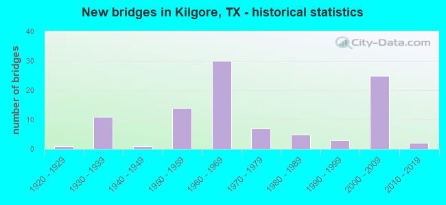
- New bridges - historical statistics
- 11920-1929
- 111930-1939
- 11940-1949
- 141950-1959
- 301960-1969
- 71970-1979
- 51980-1989
- 31990-1999
- 252000-2009
- 22010-2019
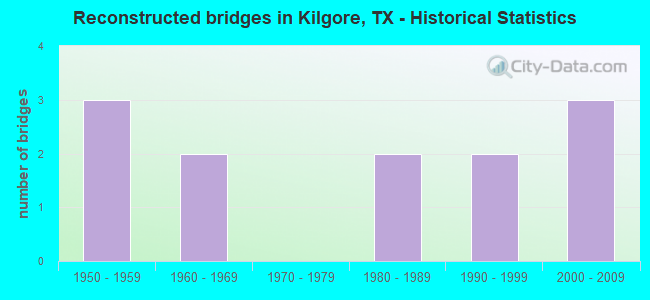
- Reconstructed bridges - Historical Statistics
- 31950-1959
- 21960-1969
- 01970-1979
- 21980-1989
- 21990-1999
- 32000-2009
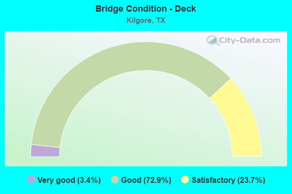
- Bridge Condition - Deck
- 3.4%Very good
- 72.9%Good
- 23.7%Satisfactory
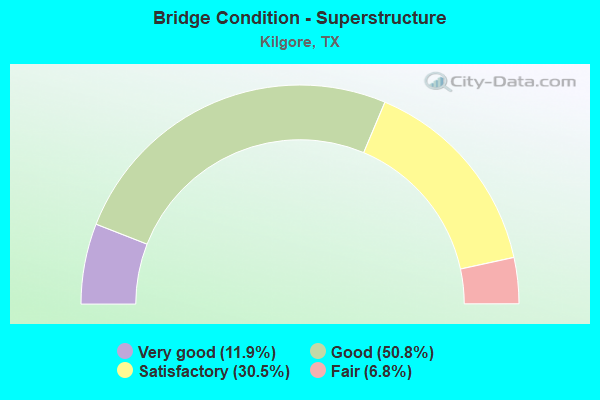
- Bridge Condition - Superstructure
- 11.9%Very good
- 50.8%Good
- 30.5%Satisfactory
- 6.8%Fair
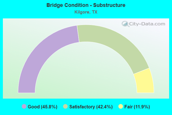
- Bridge Condition - Substructure
- 45.8%Good
- 42.4%Satisfactory
- 11.9%Fair
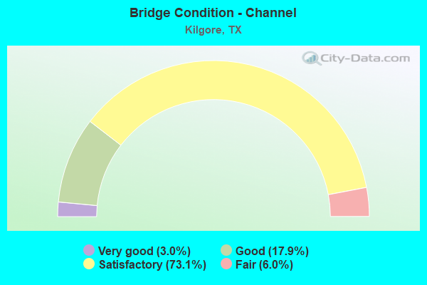
- Bridge Condition - Channel
- 3.0%Very good
- 17.9%Good
- 73.1%Satisfactory
- 6.0%Fair
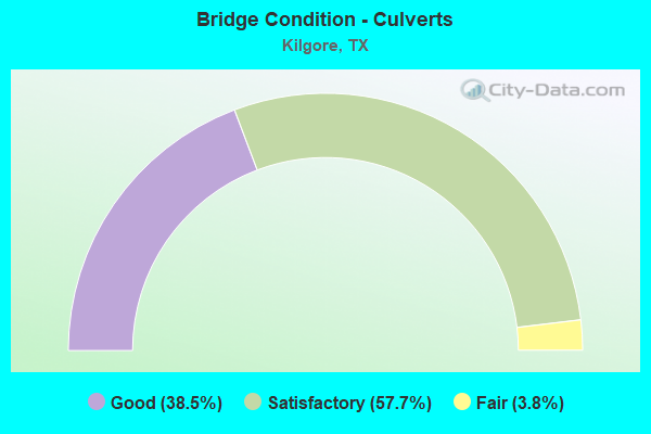
- Bridge Condition - Culverts
- 38.5%Good
- 57.7%Satisfactory
- 3.8%Fair
Find on map >> Show street view
Structure Number: 10093001381611, Location: APPROX 2MI N OF FM 2204 (Lat: 32.405733, Lng: -94.833303), Route carried "under" structure: State highway 349, Year Built: 2005, Structure Length: 0. m, Average Daily Traffic: 4,930 (year 2013), Truck Traffic: 6%, Features Intersected: FM 349, Facility Carried by Structure: US 259
Minimum Vertical Clearance: 5.89m (19.32ft), Kilometerpoint: 1.569, Lanes on structure: 3, Lanes under structure: 2, Material/Design: Prestressed concrete, Design/Construction: Stringer/Multi-beam, Length of Maximum Span: 32.0m (105.0ft)
Find on map >> Show street view
Structure Number: 100930013816112, Location: 2MI N OF FM 349 (Lat: 32.381517, Lng: -94.830872), Route carried "under" structure: Alternate State highway 2204, Year Built: 2005, Structure Length: 0. m, Average Daily Traffic: 4,540 (year 2013), Truck Traffic: 5%, Features Intersected: FM 2204, Facility Carried by Structure: US 259
Minimum Vertical Clearance: 5.49m (18.01ft), Kilometerpoint: 3.413, Lanes on structure: 2, Lanes under structure: 3, Material/Design: Prestressed concrete, Design/Construction: Stringer/Multi-beam, Length of Maximum Span: 32.0m (105.0ft)
Find on map >> Show street view
Structure Number: 100930042402033, Location: 1.45 MI SW OF SH 42 (Lat: 32.392508, Lng: -94.890733), Route carried "under" structure: State highway 31, Year Built: 1977, Structure Length: 0. m, Average Daily Traffic: 9,050 (year 2013), Truck Traffic: 7%, Features Intersected: SH 31, Facility Carried by Structure: SH 135
Minimum Vertical Clearance: 6.30m (20.67ft), Kilometerpoint: 9.186, Lanes on structure: 5, Lanes under structure: 5, Material/Design: Prestressed concrete, Design/Construction: Stringer/Multi-beam, Length of Maximum Span: 30.5m (100.1ft)
Find on map >> Show street view
Structure Number: 100930049507254, Location: 2.35 MI W OF SH 42 (Lat: 32.432350, Lng: -94.902344), Route carried "under" structure: Interstate 20, Year Built: 1966, Structure Length: 0. m, Average Daily Traffic: 32,550 (year 2013), Truck Traffic: 26%, Features Intersected: IH 20, Facility Carried by Structure: FRITZ SWANSON RD
Minimum Vertical Clearance: 5.21m (17.09ft), Kilometerpoint: 7.862, Lanes on structure: 2, Lanes under structure: 4, Material/Design: Prestressed concrete, Design/Construction: Stringer/Multi-beam, Length of Maximum Span: 19.8m (65.0ft)
Find on map >> Show street view
Structure Number: 100930049507256, Location: 2.05 MI W OF US 259 (Lat: 32.432514, Lng: -94.862325), Route carried "under" structure: Interstate 20, Year Built: 1966, Structure Length: 0. m, Average Daily Traffic: 32,550 (year 2013), Truck Traffic: 26%, Features Intersected: IH 20, Facility Carried by Structure: SH 42
Minimum Vertical Clearance: 5.08m (16.67ft), Kilometerpoint: 11.621, Lanes on structure: 2, Lanes under structure: 4, Material/Design: Prestressed concrete, Design/Construction: Stringer/Multi-beam, Length of Maximum Span: 19.8m (65.0ft)
Find on map >> Show street view
Structure Number: 100930049507274, Location: 1.90 MI E OF SH 42 (Lat: 32.434250, Lng: -94.830508), Route carried "under" structure: Ramp US 259, Year Built: 1967, Structure Length: 0. m, Average Daily Traffic: 1,900 (year 2010), Truck Traffic: 5%, Features Intersected: US 259 CONN RAMP, Facility Carried by Structure: IH 20 EB
Minimum Vertical Clearance: 5.18m (16.99ft), Kilometerpoint: 8.488, Lanes on structure: 2, Lanes under structure: 1, Material/Design: Steel continuous, Design/Construction: Stringer/Multi-beam, Length of Maximum Span: 22.9m (75.1ft)
Find on map >> Show street view
Structure Number: 100930049507275, Location: 2.0 MI W OF SH 42 (Lat: 32.435261, Lng: -94.827803), Route carried "under" structure: State highway 31, Year Built: 1967, Structure Length: 0. m, Average Daily Traffic: 21,480 (year 2013), Truck Traffic: 12%, Features Intersected: SH 31, Facility Carried by Structure: IH 20 WB
Minimum Vertical Clearance: 5.49m (18.01ft), Kilometerpoint: 8.626, Lanes on structure: 3, Lanes under structure: 5, Material/Design: Steel continuous, Design/Construction: Stringer/Multi-beam, Length of Maximum Span: 26.5m (86.9ft)
Find on map >> Show street view
Structure Number: 100930049507276, Location: 2.05 MI E OF SH 42 (Lat: 32.434353, Lng: -94.828747), Route carried "under" structure: State highway 31, Year Built: 1967, Structure Length: 0. m, Average Daily Traffic: 18,300 (year 2010), Truck Traffic: 13%, Features Intersected: SH 31, Facility Carried by Structure: IH 20 EB
Minimum Vertical Clearance: 5.08m (16.67ft), Kilometerpoint: 0.042, Lanes on structure: 2, Lanes under structure: 5, Material/Design: Steel continuous, Design/Construction: Stringer/Multi-beam, Length of Maximum Span: 26.5m (86.9ft)
Find on map >> Show street view
Structure Number: 100930049507285, Location: 2.32 MILES EAST OF SH 31 (Lat: 32.433781, Lng: -94.789322), Route carried "under" structure: Interstate 20, Year Built: 1967, Structure Length: 0. m, Average Daily Traffic: 33,460 (year 2013), Truck Traffic: 26%, Features Intersected: IH 20
Minimum Vertical Clearance: 5.33m (17.49ft), Kilometerpoint: 18.522, Lanes on structure: 2, Lanes under structure: 4, Material/Design: Steel continuous, Design/Construction: Stringer/Multi-beam, Length of Maximum Span: 25.9m (85.0ft)
Find on map >> Show street view
Structure Number: 100930049507386, Location: 2.2 MI E OF SH 42 (Lat: 32.435347, Lng: -94.825800), Route carried "under" structure: Ramp Interstate 20, Year Built: 1967, Structure Length: 0. m, Average Daily Traffic: 3,400 (year 2010), Truck Traffic: 34%, Features Intersected: IH 20 EB/SH 31 NB Ramp
Minimum Vertical Clearance: 5.11m (16.77ft), Kilometerpoint: 15.208, Lanes on structure: 2, Lanes under structure: 1, Material/Design: Steel continuous, Design/Construction: Stringer/Multi-beam, Length of Maximum Span: 21.3m (69.9ft)
Find on map >> Show street view
Structure Number: 102010013817113, Location: 2.5 MI NE OF US 259 BUS (Lat: 32.364864, Lng: -94.835717), Route carried "under" structure: State highway 1249, Year Built: 2006, Structure Length: 0. m, Average Daily Traffic: 2,830 (year 2013), Truck Traffic: 7%, Features Intersected: FM 1249, Facility Carried by Structure: US 259
Minimum Vertical Clearance: 5.79m (19.00ft), Kilometerpoint: 1.032, Lanes on structure: 2, Lanes under structure: 3, Material/Design: Prestressed concrete, Design/Construction: Stringer/Multi-beam, Length of Maximum Span: 32.0m (105.0ft)
Find on map >> Show street view
Structure Number: 102010013817116, Location: 0.9 MI E OF US 259 BUS (Lat: 32.355742, Lng: -94.853806), Route carried "under" structure: US 259, Year Built: 2002, Structure Length: 0. m, Average Daily Traffic: 6,520 (year 2013), Truck Traffic: 30%, Features Intersected: US 259, Facility Carried by Structure: CR 186 (BAUGHMAN )
Minimum Vertical Clearance: 6.43m (21.10ft), Kilometerpoint: 10.548, Lanes on structure: 2, Lanes under structure: 2, Material/Design: Prestressed concrete, Design/Construction: Stringer/Multi-beam, Length of Maximum Span: 39.0m (128.0ft)
Find on map >> Show street view
Structure Number: 102010013817121, Location: 4.3 MI N OF FM 918 (Lat: 32.342033, Lng: -94.867889), Route carried "under" structure: US 259, Year Built: 2006, Structure Length: 0. m, Average Daily Traffic: 6,520 (year 2013), Truck Traffic: 30%, Features Intersected: US 259
Minimum Vertical Clearance: 5.36m (17.59ft), Kilometerpoint: 12.553, Lanes on structure: 2, Lanes under structure: 2, Material/Design: Prestressed concrete, Design/Construction: Stringer/Multi-beam, Length of Maximum Span: 38.4m (126.0ft)