Bridge Statistics for Kokomo, Indiana (IN)
Condition, Traffic, Stress, Structural Evaluation, Project Costs
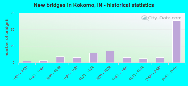
- New bridges - historical statistics
- 21920-1929
- 31930-1939
- 91940-1949
- 81950-1959
- 151960-1969
- 181970-1979
- 81980-1989
- 61990-1999
- 82000-2009
- 642010-2019
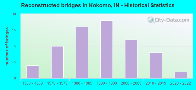
- Reconstructed bridges - Historical Statistics
- 21960-1969
- 51970-1979
- 81980-1989
- 91990-1999
- 62000-2009
- 42010-2019
- 12020-2022
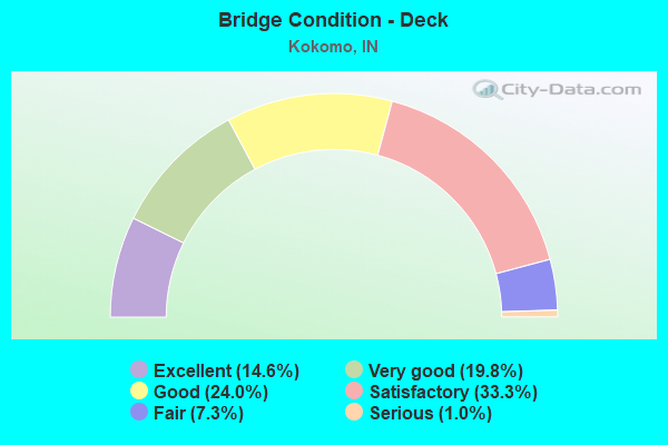
- Bridge Condition - Deck
- 14.6%Excellent
- 19.8%Very good
- 24.0%Good
- 33.3%Satisfactory
- 7.3%Fair
- 1.0%Serious
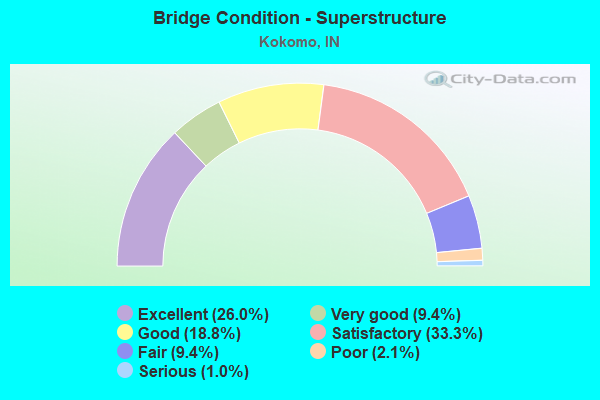
- Bridge Condition - Superstructure
- 26.0%Excellent
- 9.4%Very good
- 18.8%Good
- 33.3%Satisfactory
- 9.4%Fair
- 2.1%Poor
- 1.0%Serious
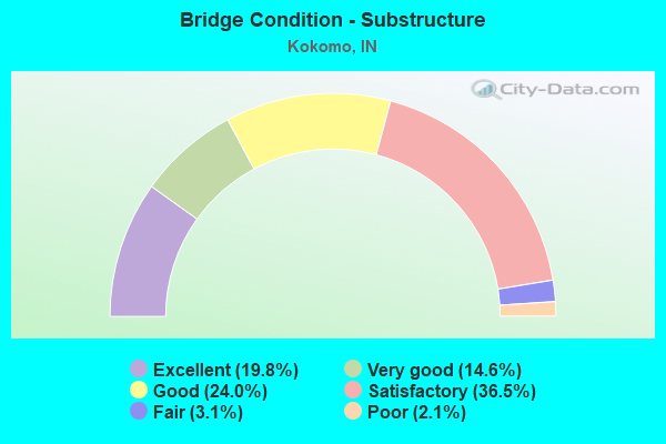
- Bridge Condition - Substructure
- 19.8%Excellent
- 14.6%Very good
- 24.0%Good
- 36.5%Satisfactory
- 3.1%Fair
- 2.1%Poor
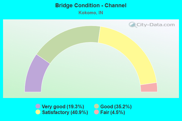
- Bridge Condition - Channel
- 19.3%Very good
- 35.2%Good
- 40.9%Satisfactory
- 4.5%Fair
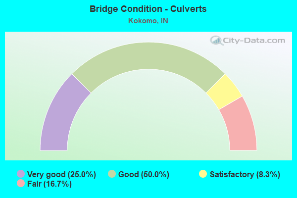
- Bridge Condition - Culverts
- 25.0%Very good
- 50.0%Good
- 8.3%Satisfactory
- 16.7%Fair
Find on map >> Show street view
Structure Number: 340007, Location: 0.1 MI E SR 19 (Lat: 40.449089, Lng: -86.031611), Route carried "on" structure: County highway 408, Year Built: 2004, Status: Open, Structure Length: 2.03m (6.66ft), Average Daily Traffic: 869 (year 2018), Truck Traffic: 5%, Average Future Daily Traffic: 1,423 (year 2038), Design Load: HS 20, Features Intersected: KOKOMO CREEK, Facility Carried by Structure: CR 200 S
Minimum Vertical Clearance: 30+ m (98+ ft), Kilometerpoint: 0.000, Lanes on structure: 2, Owner: County Highway Agency, Approaching Roadway Width: 6.7m (22.0ft), Skew: 3 degrees, Material/Design: Concrete continuous, Design/Construction: Slab, Number Of Spans In Main Unit: 3, Length of Maximum Span: 7.9m (25.9ft), Curb-To-Curb Width: 7.3m (24.0ft), Out-to-Out Width: 7.5m (24.6ft)
Condition: Deck: Good, Superstructure: Good, Substructure: Satisfactory, Channel: Good, Operating Rating: 58.8 metric tons, Method Used To Determine Operating Rating: Load Factor (LF), Inventory Rating: 35.3 metric tons, Method Used To Determine Inventory Rating: Load Factor (LF), Structural Evaluation: Equal to present minimum criteria, Deck Geometry: Meets minimum limits, Waterway Adequacy: Better than present minimum criteria, Approach Roadway Alignment: Equal to present minimum criteria, Designated Inspection Frequency: Every 24 months, Inspection Date: November 2020, Deck Structure Type: Concrete Cast-file-Place, Wearing Surface/Protective System: Wearing Surface: Monolithic Concrete, Deck Protection: Epoxy Coated Reinforcing
Find on map >> Show street view
Structure Number: 3400071, Location: 0.4 MI W SR 19 (Lat: 40.449000, Lng: -86.038489), Route carried "on" structure: County highway 408, Year Built: 1979, Status: Open, Structure Length: 2.94m (9.65ft), Average Daily Traffic: 3,099 (year 2018), Truck Traffic: 5%, Average Future Daily Traffic: 5,076 (year 2038), Design Load: HS 20, Features Intersected: KOKOMO CREEK, Facility Carried by Structure: CR 200 S
Minimum Vertical Clearance: 30+ m (98+ ft), Kilometerpoint: 0.000, Lanes on structure: 2, Owner: County Highway Agency, Approaching Roadway Width: 6.4m (21.0ft), Skew: 4 degrees, Material/Design: Prestressed concrete continuous, Design/Construction: Box Beam or Girders - Multiple, Number Of Spans In Main Unit: 3, Length of Maximum Span: 11.0m (36.1ft), Curb-To-Curb Width: 9.1m (29.9ft), Out-to-Out Width: 9.3m (30.5ft)
Condition: Deck: Good, Superstructure: Good, Substructure: Good, Channel: Satisfactory, Operating Rating: 52.6 metric tons, Method Used To Determine Operating Rating: Load Factor (LF), Inventory Rating: 31.3 metric tons, Method Used To Determine Inventory Rating: Load Factor (LF), Structural Evaluation: Better than present minimum criteria, Deck Geometry: Meets minimum limits, Waterway Adequacy: Better than present minimum criteria, Approach Roadway Alignment: Equal to present desirable criteria, Designated Inspection Frequency: Every 24 months, Inspection Date: November 2020, Deck Structure Type: Concrete Cast-file-Place, Wearing Surface/Protective System: Wearing Surface: Monolithic Concrete
Find on map >> Show street view
Structure Number: 3400072, Location: 0.2 MI S SOUTHWAY BLVD (Lat: 40.446469, Lng: -86.108289), Route carried "on" structure: City street , Year Built: 1979, Status: Open, Structure Length: 4.47m (14.67ft), Average Daily Traffic: 4,637 (year 2018), Truck Traffic: 5%, Average Future Daily Traffic: 7,595 (year 2038), Features Intersected: KOKOMO CREEK, Facility Carried by Structure: ALBRIGHT RD
Minimum Vertical Clearance: 30+ m (98+ ft), Kilometerpoint: 0.000, Lanes on structure: 2, Owner: County Highway Agency, Approaching Roadway Width: 7.3m (24.0ft), Skew: 3 degrees, Material/Design: Prestressed concrete continuous, Design/Construction: Box Beam or Girders - Multiple, Number Of Spans In Main Unit: 3, Length of Maximum Span: 16.8m (55.1ft), Curb-To-Curb Width: 10.4m (34.1ft), Out-to-Out Width: 11.2m (36.7ft)
Condition: Deck: Good, Superstructure: Satisfactory, Substructure: Good, Channel: Satisfactory, Operating Rating: 54.5 metric tons, Method Used To Determine Operating Rating: Field evaluation and documented engineering judgment, Inventory Rating: 32.7 metric tons, Method Used To Determine Inventory Rating: Field evaluation and documented engineering judgment, Structural Evaluation: Equal to present minimum criteria, Deck Geometry: Somewhat better than minimum adequacy, Waterway Adequacy: Better than present minimum criteria, Approach Roadway Alignment: Equal to present desirable criteria, Designated Inspection Frequency: Every 24 months, Inspection Date: November 2020, Deck Structure Type: Concrete Cast-file-Place, Wearing Surface/Protective System: Wearing Surface: Integral Concrete
Find on map >> Show street view
Structure Number: 3400073, Location: 0.4 MI N LINCOLN RD (Lat: 40.460800, Lng: -86.127011), Route carried "on" structure: City street , Year Built: 1940, Year Reconstructed: 2015, Status: Open, Structure Length: 3.76m (12.34ft), Average Daily Traffic: 4,492 (year 2018), Truck Traffic: 5%, Average Future Daily Traffic: 7,358 (year 2038), Features Intersected: KOKOMO CREEK, Facility Carried by Structure: LAFOUNTAIN ST
Minimum Vertical Clearance: 30+ m (98+ ft), Kilometerpoint: 0.000, Lanes on structure: 2, Owner: County Highway Agency, Approaching Roadway Width: 7.3m (24.0ft), Material/Design: Concrete, Design/Construction: Arch - Deck, Number Of Spans In Main Unit: 1, Length of Maximum Span: 19.2m (63.0ft), Curb or Sidewalk Widths: Left: 1.8m (5.9ft), Right: 0.0m, Curb-To-Curb Width: 9.1m (29.9ft), Out-to-Out Width: 10.0m (32.8ft)
Condition: Deck: Good, Superstructure: Satisfactory, Substructure: Good, Channel: Good, Operating Rating: 46.4 metric tons, Method Used To Determine Operating Rating: Field evaluation and documented engineering judgment, Inventory Rating: 27.8 metric tons, Method Used To Determine Inventory Rating: Field evaluation and documented engineering judgment, Structural Evaluation: Equal to present minimum criteria, Deck Geometry: Meets minimum limits, Waterway Adequacy: Equal to present minimum criteria, Approach Roadway Alignment: Equal to present desirable criteria, Designated Inspection Frequency: Every 24 months, Inspection Date: November 2020, Deck Structure Type: Concrete Cast-file-Place, Wearing Surface/Protective System: Wearing Surface: Monolithic Concrete, Deck Protection: Epoxy Coated Reinforcing
Find on map >> Show street view
Structure Number: 3400076, Location: 0.2 MI S CR 200 S (Lat: 40.446611, Lng: -86.050900), Route carried "on" structure: County highway 41, Year Built: 1993, Status: Open, Structure Length: 2.97m (9.74ft), Average Daily Traffic: 1,358 (year 2018), Truck Traffic: 5%, Average Future Daily Traffic: 2,224 (year 2038), Features Intersected: KOKOMO CREEK, Facility Carried by Structure: CR 400 E
Minimum Vertical Clearance: 30+ m (98+ ft), Kilometerpoint: 0.000, Lanes on structure: 2, Owner: County Highway Agency, Approaching Roadway Width: 6.1m (20.0ft), Material/Design: Prestressed concrete continuous, Design/Construction: Box Beam or Girders - Multiple, Number Of Spans In Main Unit: 3, Length of Maximum Span: 10.8m (35.4ft), Curb-To-Curb Width: 7.3m (24.0ft), Out-to-Out Width: 7.5m (24.6ft)
Condition: Deck: Good, Superstructure: Satisfactory, Substructure: Good, Channel: Good, Operating Rating: 51.9 metric tons, Method Used To Determine Operating Rating: Field evaluation and documented engineering judgment, Inventory Rating: 31.0 metric tons, Method Used To Determine Inventory Rating: Field evaluation and documented engineering judgment, Structural Evaluation: Equal to present minimum criteria, Deck Geometry: Meets minimum limits, Waterway Adequacy: Better than present minimum criteria, Approach Roadway Alignment: Equal to present desirable criteria, Designated Inspection Frequency: Every 24 months, Inspection Date: November 2020, Deck Structure Type: Concrete Cast-file-Place, Wearing Surface/Protective System: Wearing Surface: Monolithic Concrete
Find on map >> Show street view
Structure Number: 3400077, Location: 0.2 MI S SR 26 (Lat: 40.416369, Lng: -86.117611), Route carried "on" structure: County highway 169, Year Built: 1920, Year Reconstructed: 2014, Status: Open, Structure Length: 0.85m (2.79ft), Average Daily Traffic: 456 (year 2018), Truck Traffic: 5%, Average Future Daily Traffic: 746 (year 2038), Design Load: HL 93, Features Intersected: EAST FORK LITTLE WILDCAT, Facility Carried by Structure: CR 50 E
Minimum Vertical Clearance: 30+ m (98+ ft), Kilometerpoint: 0.000, Lanes on structure: 2, Owner: County Highway Agency, Approaching Roadway Width: 5.2m (17.1ft), Skew: 4 degrees, Material/Design: Concrete, Design/Construction: Slab, Number Of Spans In Main Unit: 1, Length of Maximum Span: 7.8m (25.6ft), Curb-To-Curb Width: 7.0m (23.0ft), Out-to-Out Width: 7.2m (23.6ft)
Condition: Deck: Good, Superstructure: Good, Substructure: Satisfactory, Channel: Good, Operating Rating: 54.5 metric tons, Method Used To Determine Operating Rating: Load and Resistance Factor (LRFR), Inventory Rating: 32.7 metric tons, Method Used To Determine Inventory Rating: Load and Resistance Factor (LRFR), Structural Evaluation: Equal to present minimum criteria, Deck Geometry: Meets minimum limits, Waterway Adequacy: Equal to present minimum criteria, Approach Roadway Alignment: Equal to present desirable criteria, Designated Inspection Frequency: Every 24 months, Inspection Date: November 2020, Deck Structure Type: Concrete Cast-file-Place, Wearing Surface/Protective System: Wearing Surface: Monolithic Concrete, Deck Protection: Epoxy Coated Reinforcing
Find on map >> Show street view
Structure Number: 3400078, Location: 0.3 MI N CR 300 S (Lat: 40.440989, Lng: -86.089139), Route carried "on" structure: City street , Year Built: 1940, Year Reconstructed: 2014, Status: Posted for load, Structure Length: 1.31m (4.30ft), Average Daily Traffic: 3,055 (year 2018), Truck Traffic: 5%, Average Future Daily Traffic: 5,003 (year 2038), Features Intersected: KOKOMO CREEK, Facility Carried by Structure: IZAAK WALTON RD
Minimum Vertical Clearance: 30+ m (98+ ft), Kilometerpoint: 0.000, Lanes on structure: 2, Owner: County Highway Agency, Approaching Roadway Width: 6.1m (20.0ft), Material/Design: Steel, Design/Construction: Stringer/Multi-beam, Number Of Spans In Main Unit: 1, Length of Maximum Span: 12.8m (42.0ft), Curb-To-Curb Width: 8.0m (26.2ft), Out-to-Out Width: 8.2m (26.9ft)
Condition: Deck: Satisfactory, Superstructure: Fair, Substructure: Satisfactory, Channel: Satisfactory, Operating Rating: 23.7 metric tons, Method Used To Determine Operating Rating: Load Factor (LF), Inventory Rating: 14.2 metric tons, Method Used To Determine Inventory Rating: Load Factor (LF), Structural Evaluation: Meets minimum limits, Deck Geometry: High priority of corrective action, Waterway Adequacy: Better than present minimum criteria, Approach Roadway Alignment: Equal to present minimum criteria, Bridge Posting: Required (Relationship of Operating Rating to Maximum Legal Load: 20.0 - 29.9% below), Length Of Structure Improvement: 1.98m (6.50ft), Designated Inspection Frequency: Every 24 months, Inspection Date: November 2020, Bridge Improvement Cost: $344,000, Roadway Improvement Cost: $253,000, Total Project Cost: $597,000 ( Estimate for 2020), Deck Structure Type: Concrete Cast-file-Place, Wearing Surface/Protective System: Wearing Surface: Monolithic Concrete
Find on map >> Show street view
Structure Number: 340011, Location: 0.0 MI INT BOULEVARD ST (Lat: 40.462269, Lng: -86.136469), Route carried "on" structure: City street , Year Built: 1973, Status: Open, Structure Length: 4.33m (14.21ft), Average Daily Traffic: 9,287 (year 2018), Truck Traffic: 5%, Average Future Daily Traffic: 15,213 (year 2038), Design Load: HS 20, Features Intersected: KOKOMO CREEK, Facility Carried by Structure: WEBSTER ST
Minimum Vertical Clearance: 30+ m (98+ ft), Kilometerpoint: 0.000, Lanes on structure: 4, Owner: County Highway Agency, Approaching Roadway Width: 13.1m (43.0ft), Skew: 1 degrees, Material/Design: Prestressed concrete continuous, Design/Construction: Box Beam or Girders - Multiple, Number Of Spans In Main Unit: 3, Length of Maximum Span: 14.3m (46.9ft), Curb or Sidewalk Widths: Left: 1.5m (4.9ft), Right: 0.1m (0.3ft), Curb-To-Curb Width: 13.0m (42.7ft), Out-to-Out Width: 15.3m (50.2ft)
Condition: Deck: Satisfactory, Superstructure: Good, Substructure: Satisfactory, Channel: Satisfactory, Operating Rating: 56.5 metric tons, Method Used To Determine Operating Rating: Load Factor (LF), Inventory Rating: 30.7 metric tons, Method Used To Determine Inventory Rating: Load Factor (LF), Structural Evaluation: Equal to present minimum criteria, Deck Geometry: High priority of replacement, Waterway Adequacy: Better than present minimum criteria, Approach Roadway Alignment: Equal to present desirable criteria, Length Of Structure Improvement: 4.33m (14.21ft), Designated Inspection Frequency: Every 24 months, Inspection Date: November 2020, Bridge Improvement Cost: $95,000, Roadway Improvement Cost: $31,000, Total Project Cost: $126,000 ( Estimate for 2020), Deck Structure Type: Concrete Cast-file-Place, Wearing Surface/Protective System: Wearing Surface: Monolithic Concrete
Find on map >> Show street view
Structure Number: 3400111, Location: 0.0 MI INT BOULEVARD ST (Lat: 40.462119, Lng: -86.133689), Route carried "on" structure: City street , Year Built: 1930, Year Reconstructed: 1960, Status: Open, Structure Length: 2.26m (7.41ft), Average Daily Traffic: 9,845 (year 2018), Truck Traffic: 5%, Average Future Daily Traffic: 16,126 (year 2038), Design Load: HS 20, Features Intersected: KOKOMO CREEK, Facility Carried by Structure: WASHINGTON ST
Minimum Vertical Clearance: 30+ m (98+ ft), Kilometerpoint: 0.000, Lanes on structure: 4, Owner: County Highway Agency, Approaching Roadway Width: 17.1m (56.1ft), Skew: 3 degrees, Material/Design: Concrete, Design/Construction: Culvert, Number Of Spans In Main Unit: 1, Length of Maximum Span: 18.3m (60.0ft), Curb or Sidewalk Widths: Left: 2.0m (6.6ft), Right: 2.0m (6.6ft), Curb-To-Curb Width: 14.8m (48.6ft), Out-to-Out Width: 17.5m (57.4ft)
Condition: Channel: Good, Culverts: Satisfactory, Operating Rating: 54.5 metric tons, Method Used To Determine Operating Rating: Field evaluation and documented engineering judgment, Inventory Rating: 32.7 metric tons, Method Used To Determine Inventory Rating: Field evaluation and documented engineering judgment, Structural Evaluation: Equal to present minimum criteria, Deck Geometry: High priority of replacement, Waterway Adequacy: Better than present minimum criteria, Approach Roadway Alignment: Equal to present desirable criteria, Designated Inspection Frequency: Every 24 months, Inspection Date: November 2020
Find on map >> Show street view
Structure Number: 3400113, Location: 0.5 MI S CR 400 N (Lat: 40.524861, Lng: -86.222300), Route carried "on" structure: County highway 19, Year Built: 1930, Status: Open, Structure Length: 0.70m (2.30ft), Average Daily Traffic: 186 (year 2018), Truck Traffic: 5%, Average Future Daily Traffic: 305 (year 2038), Features Intersected: LITTLE DEER CREEK, Facility Carried by Structure: CR 500 W
Minimum Vertical Clearance: 30+ m (98+ ft), Kilometerpoint: 0.000, Lanes on structure: 2, Owner: County Highway Agency, Approaching Roadway Width: 5.2m (17.1ft), Skew: 6 degrees, Material/Design: Concrete, Design/Construction: Slab, Number Of Spans In Main Unit: 1, Length of Maximum Span: 6.6m (21.7ft), Curb-To-Curb Width: 6.1m (20.0ft), Out-to-Out Width: 6.7m (22.0ft)
Condition: Deck: Satisfactory, Superstructure: Satisfactory, Substructure: Satisfactory, Channel: Good, Operating Rating: 53.5 metric tons, Method Used To Determine Operating Rating: Field evaluation and documented engineering judgment, Inventory Rating: 32.0 metric tons, Method Used To Determine Inventory Rating: Field evaluation and documented engineering judgment, Structural Evaluation: Equal to present minimum criteria, Deck Geometry: Meets minimum limits, Waterway Adequacy: Somewhat better than minimum adequacy, Approach Roadway Alignment: Equal to present desirable criteria, Designated Inspection Frequency: Every 24 months, Inspection Date: November 2020, Deck Structure Type: Concrete Cast-file-Place, Wearing Surface/Protective System: Wearing Surface: Bituminous
Find on map >> Show street view
Structure Number: 3400119, Location: 0.0 MI INT CARTER ST (Lat: 40.483319, Lng: -86.117431), Route carried "on" structure: City street , Year Built: 1950, Year Reconstructed: 2008, Status: Open, Structure Length: 4.53m (14.86ft), Average Daily Traffic: 9,019 (year 2018), Truck Traffic: 5%, Average Future Daily Traffic: 14,773 (year 2038), Design Load: HS 20, Features Intersected: WILDCAT CREEK, Facility Carried by Structure: OHIO ST
Minimum Vertical Clearance: 30+ m (98+ ft), Kilometerpoint: 0.000, Lanes on structure: 2, Owner: County Highway Agency, Approaching Roadway Width: 10.7m (35.1ft), Material/Design: Prestressed concrete continuous, Design/Construction: Box Beam or Girders - Single/Spread, Number Of Spans In Main Unit: 3, Length of Maximum Span: 16.0m (52.5ft), Curb or Sidewalk Widths: Left: 1.8m (5.9ft), Right: 1.8m (5.9ft), Curb-To-Curb Width: 10.8m (35.4ft), Out-to-Out Width: 15.0m (49.2ft)
Condition: Deck: Good, Superstructure: Good, Substructure: Good, Channel: Good, Operating Rating: 58.3 metric tons, Method Used To Determine Operating Rating: Load Factor (LF), Inventory Rating: 34.9 metric tons, Method Used To Determine Inventory Rating: Load Factor (LF), Structural Evaluation: Better than present minimum criteria, Deck Geometry: Meets minimum limits, Waterway Adequacy: Somewhat better than minimum adequacy, Approach Roadway Alignment: Equal to present desirable criteria, Designated Inspection Frequency: Every 24 months, Inspection Date: November 2020, Deck Structure Type: Concrete Cast-file-Place, Wearing Surface/Protective System: Wearing Surface: Monolithic Concrete, Deck Protection: Epoxy Coated Reinforcing
Find on map >> Show street view
Structure Number: 340012, Location: 0.0 MI INT DEFENBAUGH ST (Lat: 40.469011, Lng: -86.141961), Route carried "on" structure: City street , Year Built: 1970, Status: Open, Structure Length: 1.71m (5.61ft), Average Daily Traffic: 5,280 (year 2018), Truck Traffic: 5%, Average Future Daily Traffic: 8,648 (year 2038), Design Load: HS 20, Features Intersected: KOKOMO CREEK, Facility Carried by Structure: OLD BEN DR
Minimum Vertical Clearance: 30+ m (98+ ft), Kilometerpoint: 0.000, Lanes on structure: 2, Owner: County Highway Agency, Approaching Roadway Width: 8.2m (26.9ft), Material/Design: Prestressed concrete, Design/Construction: Box Beam or Girders - Multiple, Number Of Spans In Main Unit: 1, Length of Maximum Span: 16.8m (55.1ft), Curb or Sidewalk Widths: Left: 0.0m, Right: 1.1m (3.6ft), Curb-To-Curb Width: 8.0m (26.2ft), Out-to-Out Width: 10.2m (33.5ft)
Condition: Deck: Satisfactory, Superstructure: Satisfactory, Substructure: Satisfactory, Channel: Satisfactory, Operating Rating: 47.3 metric tons, Method Used To Determine Operating Rating: Load Factor (LF), Inventory Rating: 28.4 metric tons, Method Used To Determine Inventory Rating: Load Factor (LF), Structural Evaluation: Equal to present minimum criteria, Deck Geometry: High priority of replacement, Waterway Adequacy: Somewhat better than minimum adequacy, Approach Roadway Alignment: Equal to present minimum criteria, Designated Inspection Frequency: Every 24 months, Inspection Date: November 2020, Deck Structure Type: Concrete Precast Panels, Wearing Surface/Protective System: Wearing Surface: Bituminous
Find on map >> Show street view
Structure Number: 3400121, Location: 0.0 MI INT MAPLE ST (Lat: 40.483589, Lng: -86.141919), Route carried "on" structure: City street , Year Built: 1963, Year Reconstructed: 2021, Status: Open, Structure Length: 8.00m (26.25ft), Average Daily Traffic: 1,910 (year 2018), Truck Traffic: 5%, Average Future Daily Traffic: 3,129 (year 2038), Design Load: HL 93, Features Intersected: WILDCAT CREEK, Facility Carried by Structure: MCCANN ST
Minimum Vertical Clearance: 30+ m (98+ ft), Kilometerpoint: 0.000, Lanes on structure: 2, Owner: County Highway Agency, Approaching Roadway Width: 7.9m (25.9ft), Skew: 2 degrees, Material/Design: Steel continuous, Design/Construction: Stringer/Multi-beam, Number Of Spans In Main Unit: 3, Length of Maximum Span: 31.1m (102.0ft), Curb or Sidewalk Widths: Left: 1.5m (4.9ft), Right: 1.5m (4.9ft), Curb-To-Curb Width: 7.9m (25.9ft), Out-to-Out Width: 11.6m (38.1ft)
Condition: Deck: Very good, Superstructure: Excellent, Substructure: Good, Channel: Good, Operating Rating: 53.1 metric tons, Method Used To Determine Operating Rating: Load and Resistance Factor Rating (LRFR) rating reported by rating factor(RF) method using HL-93 loadings, Inventory Rating: 40.8 metric tons, Method Used To Determine Inventory Rating: Load and Resistance Factor Rating (LRFR) rating reported by rating factor(RF) method using HL-93 loadings, Structural Evaluation: Better than present minimum criteria, Deck Geometry: Meets minimum limits, Waterway Adequacy: Equal to present desirable criteria, Approach Roadway Alignment: Equal to present desirable criteria, Designated Inspection Frequency: Every 24 months, Inspection Date: November 2021, Deck Structure Type: Concrete Cast-file-Place, Wearing Surface/Protective System: Wearing Surface: Monolithic Concrete, Deck Protection: Epoxy Coated Reinforcing
Find on map >> Show street view
Structure Number: 3400122, Location: 0.0 MI INT SUPERIOR ST (Lat: 40.484311, Lng: -86.129939), Route carried "on" structure: City street , Year Built: 1958, Year Reconstructed: 1998, Status: Open, Structure Length: 4.00m (13.12ft), Average Daily Traffic: 6,909 (year 2018), Truck Traffic: 5%, Average Future Daily Traffic: 11,316 (year 2038), Design Load: HS 20, Features Intersected: WILDCAT CREEK, Facility Carried by Structure: UNION ST
Minimum Vertical Clearance: 30+ m (98+ ft), Kilometerpoint: 0.000, Lanes on structure: 2, Owner: County Highway Agency, Approaching Roadway Width: 6.7m (22.0ft), Material/Design: Prestressed concrete, Design/Construction: Stringer/Multi-beam, Number Of Spans In Main Unit: 2, Length of Maximum Span: 19.4m (63.6ft), Curb or Sidewalk Widths: Left: 1.8m (5.9ft), Right: 1.8m (5.9ft), Curb-To-Curb Width: 13.4m (44.0ft), Out-to-Out Width: 17.2m (56.4ft)
Condition: Deck: Satisfactory, Superstructure: Fair, Substructure: Poor, Channel: Satisfactory, Operating Rating: 75.3 metric tons, Method Used To Determine Operating Rating: Load Factor (LF), Inventory Rating: 39.7 metric tons, Method Used To Determine Inventory Rating: Load Factor (LF), Structural Evaluation: Meets minimum limits, Deck Geometry: Equal to present minimum criteria, Waterway Adequacy: Somewhat better than minimum adequacy, Approach Roadway Alignment: Equal to present desirable criteria, Designated Inspection Frequency: Every 12 months, Inspection Date: November 2021, Deck Structure Type: Concrete Cast-file-Place, Wearing Surface/Protective System: Wearing Surface: Integral Concrete
Find on map >> Show street view
Structure Number: 3400123, Location: 0.0 MI INT SUPERIOR ST (Lat: 40.484461, Lng: -86.131200), Route carried "on" structure: City street , Year Built: 1941, Year Reconstructed: 1993, Status: Open, Structure Length: 3.97m (13.02ft), Average Daily Traffic: 5,027 (year 2018), Truck Traffic: 5%, Average Future Daily Traffic: 8,234 (year 2038), Design Load: H 20, Features Intersected: WILDCAT CREEK, Facility Carried by Structure: MAIN ST
Minimum Vertical Clearance: 30+ m (98+ ft), Kilometerpoint: 0.000, Lanes on structure: 2, Owner: County Highway Agency, Approaching Roadway Width: 7.3m (24.0ft), Material/Design: Steel continuous, Design/Construction: Stringer/Multi-beam, Number Of Spans In Main Unit: 3, Length of Maximum Span: 14.6m (47.9ft), Curb or Sidewalk Widths: Left: 2.7m (8.9ft), Right: 2.7m (8.9ft), Curb-To-Curb Width: 11.9m (39.0ft), Out-to-Out Width: 18.3m (60.0ft)
Condition: Deck: Good, Superstructure: Satisfactory, Substructure: Good, Channel: Good, Operating Rating: 57.1 metric tons, Method Used To Determine Operating Rating: Load Factor (LF), Inventory Rating: 34.3 metric tons, Method Used To Determine Inventory Rating: Load Factor (LF), Structural Evaluation: Equal to present minimum criteria, Deck Geometry: Somewhat better than minimum adequacy, Waterway Adequacy: Somewhat better than minimum adequacy, Approach Roadway Alignment: Equal to present desirable criteria, Designated Inspection Frequency: Every 24 months, Underwater Inspection Frequency: Every 48 months, Inspection Date: November 2020, Underwater Inspection Date: September 2019, Deck Structure Type: Concrete Cast-file-Place, Wearing Surface/Protective System: Wearing Surface: Monolithic Concrete, Deck Protection: Epoxy Coated Reinforcing
Find on map >> Show street view
Structure Number: 3400124, Location: 0.0 MI INT SUPERIOR ST (Lat: 40.484161, Lng: -86.127000), Route carried "on" structure: City street , Year Built: 1929, Year Reconstructed: 1987, Status: Open, Structure Length: 4.40m (14.44ft), Average Daily Traffic: 9,819 (year 2018), Truck Traffic: 5%, Average Future Daily Traffic: 16,084 (year 2038), Design Load: HS 20, Features Intersected: WILDCAT CREEK, Facility Carried by Structure: APPERSON WAY
Minimum Vertical Clearance: 30+ m (98+ ft), Kilometerpoint: 0.000, Lanes on structure: 2, Owner: County Highway Agency, Approaching Roadway Width: 12.5m (41.0ft), Material/Design: Concrete, Design/Construction: Arch - Deck, Number Of Spans In Main Unit: 2, Length of Maximum Span: 21.7m (71.2ft), Curb or Sidewalk Widths: Left: 1.7m (5.6ft), Right: 1.7m (5.6ft), Curb-To-Curb Width: 14.4m (47.2ft), Out-to-Out Width: 18.6m (61.0ft)
Condition: Deck: Satisfactory, Superstructure: Satisfactory, Substructure: Satisfactory, Channel: Satisfactory, Operating Rating: 54.5 metric tons, Method Used To Determine Operating Rating: Field evaluation and documented engineering judgment, Inventory Rating: 32.7 metric tons, Method Used To Determine Inventory Rating: Field evaluation and documented engineering judgment, Structural Evaluation: Equal to present minimum criteria, Deck Geometry: Superior to present desirable criteria, Waterway Adequacy: Equal to present desirable criteria, Approach Roadway Alignment: High priority of corrective action, Designated Inspection Frequency: Every 24 months, Inspection Date: November 2020, Deck Structure Type: Concrete Precast Panels, Wearing Surface/Protective System: Wearing Surface: Monolithic Concrete
Find on map >> Show street view
Structure Number: 3400125, Location: 0.2 MI NE PARK RD (Lat: 40.471150, Lng: -86.144531), Route carried "on" structure: City street , Year Built: 1970, Year Reconstructed: 1999, Status: Posted for load, Structure Length: 2.44m (8.01ft), Average Daily Traffic: 6,263 (year 2018), Truck Traffic: 5%, Average Future Daily Traffic: 10,259 (year 2038), Design Load: HS 20, Features Intersected: KOKOMO CREEK, Facility Carried by Structure: DEFENBAUGH ST
Minimum Vertical Clearance: 30+ m (98+ ft), Kilometerpoint: 0.000, Lanes on structure: 2, Owner: County Highway Agency, Approaching Roadway Width: 7.3m (24.0ft), Skew: 1 degrees, Material/Design: Prestressed concrete, Design/Construction: Box Beam or Girders - Multiple, Number Of Spans In Main Unit: 2, Length of Maximum Span: 11.6m (38.1ft), Curb-To-Curb Width: 8.4m (27.6ft), Out-to-Out Width: 8.6m (28.2ft)
Condition: Deck: Serious, Superstructure: Serious, Substructure: Fair, Channel: Satisfactory, Operating Rating: 25.5 metric tons, Method Used To Determine Operating Rating: Load Factor (LF), Inventory Rating: 15.7 metric tons, Method Used To Determine Inventory Rating: Load Factor (LF), Structural Evaluation: High priority of corrective action, Deck Geometry: High priority of replacement, Waterway Adequacy: Equal to present minimum criteria, Approach Roadway Alignment: Equal to present minimum criteria, Bridge Posting: Required (Relationship of Operating Rating to Maximum Legal Load: 20.0 - 29.9% below), Length Of Structure Improvement: 2.44m (8.01ft), Designated Inspection Frequency: Every 12 months, Inspection Date: November 2021, Bridge Improvement Cost: $325,000, Roadway Improvement Cost: $180,000, Total Project Cost: $505,000 ( Estimate for 2020), Deck Structure Type: Concrete Precast Panels, Wearing Surface/Protective System: Wearing Surface: Bituminous
Find on map >> Show street view
Structure Number: 3400127, Location: 0.0 MI INT PARK AVE (Lat: 40.481150, Lng: -86.146169), Route carried "on" structure: City street , Year Built: 1989, Status: Open, Structure Length: 8.20m (26.90ft), Average Daily Traffic: 5,996 (year 2018), Truck Traffic: 5%, Average Future Daily Traffic: 9,821 (year 2038), Design Load: HS 20, Features Intersected: WILDCAT CREEK, Facility Carried by Structure: PHILLIPS ST
Minimum Vertical Clearance: 30+ m (98+ ft), Kilometerpoint: 0.000, Lanes on structure: 2, Owner: County Highway Agency, Approaching Roadway Width: 9.1m (29.9ft), Skew: 3 degrees, Material/Design: Prestressed concrete continuous, Design/Construction: Box Beam or Girders - Single/Spread, Number Of Spans In Main Unit: 4, Length of Maximum Span: 20.9m (68.6ft), Curb or Sidewalk Widths: Left: 1.8m (5.9ft), Right: 1.8m (5.9ft), Curb-To-Curb Width: 9.1m (29.9ft), Out-to-Out Width: 13.8m (45.3ft)
Condition: Deck: Good, Superstructure: Very good, Substructure: Good, Channel: Good, Operating Rating: 77.7 metric tons, Method Used To Determine Operating Rating: Load Factor (LF), Inventory Rating: 38.2 metric tons, Method Used To Determine Inventory Rating: Load Factor (LF), Structural Evaluation: Better than present minimum criteria, Deck Geometry: Meets minimum limits, Waterway Adequacy: Equal to present desirable criteria, Approach Roadway Alignment: Equal to present minimum criteria, Designated Inspection Frequency: Every 24 months, Inspection Date: November 2020, Deck Structure Type: Concrete Cast-file-Place, Wearing Surface/Protective System: Wearing Surface: Monolithic Concrete, Deck Protection: Epoxy Coated Reinforcing
Find on map >> Show street view
Structure Number: 3400128, Location: 0.0 MI INT PARK AVE (Lat: 40.476339, Lng: -86.149039), Route carried "on" structure: City street , Year Built: 1940, Year Reconstructed: 1984, Status: Open, Structure Length: 3.74m (12.27ft), Average Daily Traffic: 5,821 (year 2018), Truck Traffic: 5%, Average Future Daily Traffic: 9,534 (year 2038), Design Load: H 20, Features Intersected: WILDCAT CREEK, Facility Carried by Structure: MARKLAND AVE
Minimum Vertical Clearance: 30+ m (98+ ft), Kilometerpoint: 0.000, Lanes on structure: 2, Owner: County Highway Agency, Approaching Roadway Width: 8.2m (26.9ft), Material/Design: Steel continuous, Design/Construction: Stringer/Multi-beam, Number Of Spans In Main Unit: 3, Length of Maximum Span: 14.1m (46.3ft), Curb or Sidewalk Widths: Left: 0.9m (3.0ft), Right: 0.0m, Curb-To-Curb Width: 8.2m (26.9ft), Out-to-Out Width: 9.9m (32.5ft)
Condition: Deck: Good, Superstructure: Satisfactory, Substructure: Satisfactory, Channel: Satisfactory, Operating Rating: 46.4 metric tons, Method Used To Determine Operating Rating: Load Factor (LF), Inventory Rating: 27.8 metric tons, Method Used To Determine Inventory Rating: Load Factor (LF), Structural Evaluation: Equal to present minimum criteria, Deck Geometry: High priority of replacement, Waterway Adequacy: Somewhat better than minimum adequacy, Approach Roadway Alignment: Equal to present desirable criteria, Designated Inspection Frequency: Every 24 months, Inspection Date: November 2020, Deck Structure Type: Concrete Cast-file-Place, Wearing Surface/Protective System: Wearing Surface: Monolithic Concrete, Deck Protection: Epoxy Coated Reinforcing
Find on map >> Show street view
Structure Number: 3400129, Location: 0.3 MI E LAFOUNTAIN ST (Lat: 40.455339, Lng: -86.122619), Route carried "on" structure: City street , Year Built: 1965, Year Reconstructed: 1993, Status: Open, Structure Length: 3.71m (12.17ft), Average Daily Traffic: 11,547 (year 2018), Truck Traffic: 5%, Average Future Daily Traffic: 18,914 (year 2038), Design Load: HS 20, Features Intersected: KOKOMO CREEK, Facility Carried by Structure: LINCOLN RD
Minimum Vertical Clearance: 30+ m (98+ ft), Kilometerpoint: 0.000, Lanes on structure: 2, Owner: County Highway Agency, Approaching Roadway Width: 7.9m (25.9ft), Skew: 2 degrees, Material/Design: Concrete continuous, Design/Construction: Slab, Number Of Spans In Main Unit: 3, Length of Maximum Span: 13.7m (44.9ft), Curb-To-Curb Width: 8.5m (27.9ft), Out-to-Out Width: 10.5m (34.4ft)
Condition: Deck: Satisfactory, Superstructure: Satisfactory, Substructure: Satisfactory, Channel: Satisfactory, Operating Rating: 57.5 metric tons, Method Used To Determine Operating Rating: Load Factor (LF), Inventory Rating: 34.6 metric tons, Method Used To Determine Inventory Rating: Load Factor (LF), Structural Evaluation: Equal to present minimum criteria, Deck Geometry: High priority of replacement, Waterway Adequacy: Equal to present desirable criteria, Approach Roadway Alignment: Equal to present desirable criteria, Designated Inspection Frequency: Every 24 months, Inspection Date: November 2020, Deck Structure Type: Concrete Cast-file-Place, Wearing Surface/Protective System: Wearing Surface: Integral Concrete
Find on map >> Show street view
Structure Number: 340013, Location: 0.0 MI INT WALNUT ST (Lat: 40.475400, Lng: -85.970439), Route carried "on" structure: City street , Year Built: 1966, Status: Open, Structure Length: 1.46m (4.79ft), Average Daily Traffic: 1,954 (year 2018), Truck Traffic: 5%, Average Future Daily Traffic: 3,201 (year 2038), Features Intersected: BRUNK DITCH, Facility Carried by Structure: HARRISON ST
Minimum Vertical Clearance: 30+ m (98+ ft), Kilometerpoint: 0.000, Lanes on structure: 2, Owner: County Highway Agency, Approaching Roadway Width: 7.0m (23.0ft), Skew: 3 degrees, Material/Design: Prestressed concrete, Design/Construction: Box Beam or Girders - Multiple, Number Of Spans In Main Unit: 1, Length of Maximum Span: 14.2m (46.6ft), Curb or Sidewalk Widths: Left: 1.2m (3.9ft), Right: 1.2m (3.9ft), Curb-To-Curb Width: 7.3m (24.0ft), Out-to-Out Width: 9.8m (32.2ft)
Condition: Deck: Good, Superstructure: Fair, Substructure: Satisfactory, Channel: Satisfactory, Operating Rating: 51.6 metric tons, Method Used To Determine Operating Rating: Load Factor (LF), Inventory Rating: 31.0 metric tons, Method Used To Determine Inventory Rating: Load Factor (LF), Structural Evaluation: Somewhat better than minimum adequacy, Deck Geometry: Meets minimum limits, Waterway Adequacy: Equal to present minimum criteria, Approach Roadway Alignment: Equal to present desirable criteria, Designated Inspection Frequency: Every 24 months, Inspection Date: November 2020, Deck Structure Type: Concrete Cast-file-Place, Wearing Surface/Protective System: Wearing Surface: Monolithic Concrete
Find on map >> Show street view
Structure Number: 3400133, Location: 0.2 MI W HICKORY LN (Lat: 40.480269, Lng: -86.196431), Route carried "on" structure: Alternate City street , Year Built: 1986, Status: Open, Structure Length: 0.79m (2.59ft), Average Daily Traffic: 523 (year 2018), Truck Traffic: 5%, Average Future Daily Traffic: 856 (year 2038), Design Load: HS 20, Features Intersected: BRANCH WILDCAT CREEK, Facility Carried by Structure: MAYFIELD DR
Minimum Vertical Clearance: 30+ m (98+ ft), Kilometerpoint: 0.000, Lanes on structure: 2, Owner: County Highway Agency, Approaching Roadway Width: 5.8m (19.0ft), Material/Design: Wood or Timber, Design/Construction: Slab, Number Of Spans In Main Unit: 1, Length of Maximum Span: 7.6m (24.9ft), Curb or Sidewalk Widths: Left: 0.2m (0.7ft), Right: 0.2m (0.7ft), Curb-To-Curb Width: 6.2m (20.3ft), Out-to-Out Width: 6.6m (21.7ft)
Condition: Deck: Satisfactory, Superstructure: Satisfactory, Substructure: Satisfactory, Channel: Good, Operating Rating: 59.8 metric tons, Method Used To Determine Operating Rating: Field evaluation and documented engineering judgment, Inventory Rating: 35.9 metric tons, Method Used To Determine Inventory Rating: Field evaluation and documented engineering judgment, Structural Evaluation: Equal to present minimum criteria, Deck Geometry: High priority of corrective action, Waterway Adequacy: Equal to present minimum criteria, Approach Roadway Alignment: Equal to present desirable criteria, Designated Inspection Frequency: Every 24 months, Inspection Date: November 2020, Deck Structure Type: Wood or Timber, Wearing Surface/Protective System: Wearing Surface: Bituminous
Find on map >> Show street view
Structure Number: 3400134, Location: 0.1 MI E BELMONT ST (Lat: 40.468981, Lng: -86.161089), Route carried "on" structure: City street , Year Built: 1965, Status: Posted for load, Structure Length: 1.65m (5.41ft), Average Daily Traffic: 5,192 (year 2018), Truck Traffic: 5%, Average Future Daily Traffic: 8,505 (year 2038), Features Intersected: LOCAL PLANT PASS ROAD, Facility Carried by Structure: DEFENBAUGH STREET
Minimum Vertical Clearance: 30+ m (98+ ft), Kilometerpoint: 0.000, Lanes on structure: 2, Lanes under structure: 2, Owner: Private, Approaching Roadway Width: 7.0m (23.0ft), Material/Design: Prestressed concrete, Design/Construction: Box Beam or Girders - Multiple, Number Of Spans In Main Unit: 1, Length of Maximum Span: 16.2m (53.1ft), Curb-To-Curb Width: 7.4m (24.3ft), Out-to-Out Width: 13.4m (44.0ft)
Condition: Deck: Fair, Superstructure: Fair, Substructure: Poor, Operating Rating: 25.1 metric tons, Method Used To Determine Operating Rating: Load Factor (LF), Inventory Rating: 15.0 metric tons, Method Used To Determine Inventory Rating: Load Factor (LF), Structural Evaluation: High priority of replacement, Deck Geometry: High priority of replacement, Underclear: High priority of replacement, Approach Roadway Alignment: Equal to present desirable criteria, Bridge Posting: Required (Relationship of Operating Rating to Maximum Legal Load: 20.0 - 29.9% below), Length Of Structure Improvement: 1.68m (5.51ft), Designated Inspection Frequency: Every 12 months, Inspection Date: November 2021, Bridge Improvement Cost: $436,000, Roadway Improvement Cost: $164,000, Total Project Cost: $600,000 ( Estimate for 2020), Deck Structure Type: Concrete Precast Panels, Wearing Surface/Protective System: Wearing Surface: Bituminous
Find on map >> Show street view
Structure Number: 3400137, Location: 0.1 MI S SR 26 (Lat: 40.417719, Lng: -86.088339), Route carried "on" structure: Other road , Year Built: 2012, Status: Open, Structure Length: 1.34m (4.40ft), Average Daily Traffic: 1,924 (year 2018), Truck Traffic: 5%, Average Future Daily Traffic: 3,198 (year 2038), Design Load: HL 93, Features Intersected: MARTIN-YOUNGMAN DITCH, Facility Carried by Structure: CR 200 E
Minimum Vertical Clearance: 30+ m (98+ ft), Kilometerpoint: 0.000, Lanes on structure: 2, Owner: County Highway Agency, Approaching Roadway Width: 7.9m (25.9ft), Skew: 6 degrees, Material/Design: Concrete, Design/Construction: Culvert, Number Of Spans In Main Unit: 1, Length of Maximum Span: 12.0m (39.4ft), Curb-To-Curb Width: 9.8m (32.2ft), Out-to-Out Width: 9.8m (32.2ft)
Condition: Channel: Good, Culverts: Good, Operating Rating: 54.2 metric tons, Method Used To Determine Operating Rating: Field evaluation and documented engineering judgment, Inventory Rating: 32.7 metric tons, Method Used To Determine Inventory Rating: Field evaluation and documented engineering judgment, Structural Evaluation: Better than present minimum criteria, Deck Geometry: Somewhat better than minimum adequacy, Waterway Adequacy: Better than present minimum criteria, Approach Roadway Alignment: Equal to present desirable criteria, Designated Inspection Frequency: Every 24 months, Inspection Date: November 2020
Find on map >> Show street view
Structure Number: 3400138, Location: 0.1 MI N CR 300 S (Lat: 40.437400, Lng: -86.089139), Route carried "on" structure: City street , Year Built: 2016, Status: Open, Structure Length: 1.33m (4.36ft), Average Daily Traffic: 1,454 (year 2018), Truck Traffic: 5%, Average Future Daily Traffic: 2,381 (year 2038), Features Intersected: MARTIN-YOUNGMAN DITCH, Facility Carried by Structure: IZAAK WALTON RD
Minimum Vertical Clearance: 30+ m (98+ ft), Kilometerpoint: 0.000, Lanes on structure: 2, Owner: County Highway Agency, Approaching Roadway Width: 6.7m (22.0ft), Material/Design: Prestressed concrete, Design/Construction: Box Beam or Girders - Multiple, Number Of Spans In Main Unit: 1, Length of Maximum Span: 11.6m (38.1ft), Curb-To-Curb Width: 8.4m (27.6ft), Out-to-Out Width: 8.6m (28.2ft)
Condition: Deck: Very good, Superstructure: Very good, Substructure: Very good, Channel: Satisfactory, Operating Rating: 54.5 metric tons, Method Used To Determine Operating Rating: Field evaluation and documented engineering judgment, Inventory Rating: 32.7 metric tons, Method Used To Determine Inventory Rating: Field evaluation and documented engineering judgment, Structural Evaluation: Equal to present desirable criteria, Deck Geometry: Meets minimum limits, Waterway Adequacy: Equal to present minimum criteria, Approach Roadway Alignment: Equal to present desirable criteria, Designated Inspection Frequency: Every 24 months, Inspection Date: November 2020, Deck Structure Type: Concrete Cast-file-Place, Wearing Surface/Protective System: Wearing Surface: Monolithic Concrete, Deck Protection: Epoxy Coated Reinforcing
Find on map >> Show street view
Structure Number: 340014, Location: 0.1 MI N CR 50 S (Lat: 40.470561, Lng: -86.151500), Route carried "on" structure: City street , Year Built: 2017, Status: Open, Structure Length: 3.50m (11.48ft), Average Daily Traffic: 11,702 (year 2018), Truck Traffic: 5%, Average Future Daily Traffic: 16,351 (year 2038), Design Load: HL 93, Features Intersected: KOKOMO CREEK, Facility Carried by Structure: PARK AVE
Minimum Vertical Clearance: 30+ m (98+ ft), Kilometerpoint: 0.000, Lanes on structure: 2, Owner: County Highway Agency, Approaching Roadway Width: 9.1m (29.9ft), Skew: 2 degrees, Material/Design: Prestressed concrete, Design/Construction: Stringer/Multi-beam, Number Of Spans In Main Unit: 1, Length of Maximum Span: 34.1m (111.9ft), Curb or Sidewalk Widths: Left: 1.8m (5.9ft), Right: 0.0m, Curb-To-Curb Width: 9.3m (30.5ft), Out-to-Out Width: 11.7m (38.4ft)
Condition: Deck: Very good, Superstructure: Very good, Substructure: Very good, Channel: Good, Operating Rating: 72.2 metric tons, Method Used To Determine Operating Rating: Load and Resistance Factor (LRFR), Inventory Rating: 52.2 metric tons, Method Used To Determine Inventory Rating: Load and Resistance Factor (LRFR), Structural Evaluation: Equal to present desirable criteria, Deck Geometry: High priority of corrective action, Waterway Adequacy: Equal to present desirable criteria, Approach Roadway Alignment: Equal to present minimum criteria, Designated Inspection Frequency: Every 24 months, Inspection Date: November 2020, Deck Structure Type: Concrete Cast-file-Place, Wearing Surface/Protective System: Wearing Surface: Monolithic Concrete, Deck Protection: Epoxy Coated Reinforcing
Find on map >> Show street view
Structure Number: 8000001, Location: 00.01 N OF CR 450 N (Lat: 40.368450, Lng: -86.146039), Route carried "on" structure: County highway 25, Year Built: 2004, Status: Open, Structure Length: 1.74m (5.71ft), Average Daily Traffic: 125 (year 2018), Truck Traffic: 2%, Average Future Daily Traffic: 200 (year 2038), Design Load: HS 20, Features Intersected: MUD CREEK, Facility Carried by Structure: CR 700W
Minimum Vertical Clearance: 30+ m (98+ ft), Kilometerpoint: 0.000, Lanes on structure: 2, Owner: County Highway Agency, Approaching Roadway Width: 4.9m (16.1ft), Skew: 2 degrees, Material/Design: Prestressed concrete, Design/Construction: Box Beam or Girders - Multiple, Number Of Spans In Main Unit: 1, Length of Maximum Span: 16.6m (54.5ft), Curb-To-Curb Width: 8.4m (27.6ft), Out-to-Out Width: 8.5m (27.9ft)
Condition: Deck: Good, Superstructure: Good, Substructure: Very good, Channel: Very good, Operating Rating: 75.4 metric tons, Method Used To Determine Operating Rating: Load Factor (LF), Inventory Rating: 45.2 metric tons, Method Used To Determine Inventory Rating: Load Factor (LF), Structural Evaluation: Better than present minimum criteria, Deck Geometry: Somewhat better than minimum adequacy, Waterway Adequacy: Better than present minimum criteria, Approach Roadway Alignment: Equal to present minimum criteria, Designated Inspection Frequency: Every 24 months, Inspection Date: November 2020, Deck Structure Type: Concrete Precast Panels, Wearing Surface/Protective System: Wearing Surface: Bituminous, Membrane: Preformed Fabric
Find on map >> Show street view
Structure Number: 8000002, Location: 00.70 W OF US 31 (Lat: 40.368231, Lng: -86.138439), Route carried "on" structure: County highway 40, Year Built: 1962, Status: Posted for load, Structure Length: 2.50m (8.20ft), Average Daily Traffic: 475 (year 2018), Truck Traffic: 5%, Average Future Daily Traffic: 800 (year 2038), Design Load: HS 20, Features Intersected: MUD CREEK, Facility Carried by Structure: CR 450N
Minimum Vertical Clearance: 30+ m (98+ ft), Kilometerpoint: 0.000, Lanes on structure: 2, Owner: County Highway Agency, Approaching Roadway Width: 5.5m (18.0ft), Skew: 4 degrees, Material/Design: Concrete continuous, Design/Construction: Slab, Number Of Spans In Main Unit: 3, Length of Maximum Span: 9.8m (32.2ft), Curb or Sidewalk Widths: Left: 0.3m (1.0ft), Right: 0.3m (1.0ft), Curb-To-Curb Width: 7.3m (24.0ft), Out-to-Out Width: 8.5m (27.9ft)
Condition: Deck: Satisfactory, Superstructure: Satisfactory, Substructure: Satisfactory, Channel: Satisfactory, Operating Rating: 39.5 metric tons, Method Used To Determine Operating Rating: Load Factor (LF), Inventory Rating: 23.6 metric tons, Method Used To Determine Inventory Rating: Load Factor (LF), Structural Evaluation: Equal to present minimum criteria, Deck Geometry: Meets minimum limits, Waterway Adequacy: Equal to present desirable criteria, Approach Roadway Alignment: Equal to present desirable criteria, Designated Inspection Frequency: Every 24 months, Inspection Date: November 2020, Deck Structure Type: Concrete Cast-file-Place, Wearing Surface/Protective System: Wearing Surface: Bituminous
Find on map >> Show street view
Structure Number: 8000003, Location: 00.80 W OF CR 700 W (Lat: 40.367950, Lng: -86.160531), Route carried "on" structure: County highway 40, Year Built: 1965, Status: Open, Structure Length: 2.50m (8.20ft), Average Daily Traffic: 450 (year 2018), Truck Traffic: 5%, Average Future Daily Traffic: 700 (year 2038), Design Load: HS 20, Features Intersected: MUD CREEK, Facility Carried by Structure: CR 450N
Minimum Vertical Clearance: 30+ m (98+ ft), Kilometerpoint: 0.000, Lanes on structure: 2, Owner: County Highway Agency, Approaching Roadway Width: 5.5m (18.0ft), Skew: 5 degrees, Material/Design: Concrete continuous, Design/Construction: Slab, Number Of Spans In Main Unit: 3, Length of Maximum Span: 9.8m (32.2ft), Curb or Sidewalk Widths: Left: 0.3m (1.0ft), Right: 0.3m (1.0ft), Curb-To-Curb Width: 7.6m (24.9ft), Out-to-Out Width: 8.8m (28.9ft)
Condition: Deck: Satisfactory, Superstructure: Satisfactory, Substructure: Satisfactory, Channel: Fair, Operating Rating: 62.2 metric tons, Method Used To Determine Operating Rating: Load Factor (LF), Inventory Rating: 37.2 metric tons, Method Used To Determine Inventory Rating: Load Factor (LF), Structural Evaluation: Equal to present minimum criteria, Deck Geometry: Meets minimum limits, Waterway Adequacy: Better than present minimum criteria, Approach Roadway Alignment: Equal to present desirable criteria, Designated Inspection Frequency: Every 24 months, Inspection Date: November 2020, Deck Structure Type: Concrete Cast-file-Place, Wearing Surface/Protective System: Wearing Surface: Bituminous
Find on map >> Show street view
Structure Number: 8000025, Location: 00.70 N OF CR 600 N (Lat: 40.400781, Lng: -86.107900), Route carried "on" structure: County highway 93, Year Built: 1967, Status: Open, Structure Length: 0.69m (2.26ft), Average Daily Traffic: 100 (year 2018), Truck Traffic: 3%, Average Future Daily Traffic: 150 (year 2038), Design Load: HS 20, Features Intersected: GARD DITCH, Facility Carried by Structure: CR 500W
Minimum Vertical Clearance: 30+ m (98+ ft), Kilometerpoint: 0.000, Lanes on structure: 2, Owner: County Highway Agency, Approaching Roadway Width: 4.9m (16.1ft), Skew: 1 degrees, Material/Design: Steel, Design/Construction: Culvert, Number Of Spans In Main Unit: 2, Length of Maximum Span: 3.0m (9.8ft), Curb-To-Curb Width: 9.0m (29.5ft), Out-to-Out Width: 21.2m (69.6ft)
Condition: Channel: Satisfactory, Culverts: Fair, Operating Rating: 53.3 metric tons, Method Used To Determine Operating Rating: Load and Resistance Factor (LRFR), Inventory Rating: 47.0 metric tons, Method Used To Determine Inventory Rating: Load and Resistance Factor (LRFR), Structural Evaluation: Somewhat better than minimum adequacy, Deck Geometry: Better than present minimum criteria, Waterway Adequacy: Equal to present minimum criteria, Approach Roadway Alignment: Equal to present minimum criteria, Designated Inspection Frequency: Every 24 months, Inspection Date: November 2020, Wearing Surface/Protective System: Wearing Surface: Bituminous
Find on map >> Show street view
Structure Number: 1124, Location: 01.89 N US 31 (Lat: 40.543589, Lng: -86.162989), Route carried "under" structure: County highway , Year Built: 1970, Structure Length: 0. m, Average Daily Traffic: 2,923 (year 2004), Truck Traffic: 10%, Features Intersected: OLD US 35 NB (DAVIS RD), Facility Carried by Structure: US 35
Minimum Vertical Clearance: 7.11m (23.33ft), Kilometerpoint: 0.000, Lanes on structure: 2, Lanes under structure: 2, Material/Design: Steel continuous, Design/Construction: Stringer/Multi-beam, Length of Maximum Span: 26.7m (87.6ft)
Find on map >> Show street view
Structure Number: 76472, Location: 00.67 N US 35 (Lat: 40.484161, Lng: -86.085739), Route carried "under" structure: US 31, Year Built: 2010, Structure Length: 0. m, Average Daily Traffic: 15,000 (year 2008), Truck Traffic: 10%, Features Intersected: US 31 NB, Facility Carried by Structure: CR 50N
Minimum Vertical Clearance: 5.16m (16.93ft), Kilometerpoint: 0.000, Lanes on structure: 2, Lanes under structure: 2, Material/Design: Prestressed concrete continuous, Design/Construction: Tee Beam, Length of Maximum Span: 33.2m (108.9ft)
Find on map >> Show street view
Structure Number: 76472, Location: 00.67 N US 35 (Lat: 40.484161, Lng: -86.085739), Route carried "under" structure: US 31, Year Built: 2010, Structure Length: 0. m, Average Daily Traffic: 15,000 (year 2008), Truck Traffic: 10%, Features Intersected: US 31 SB, Facility Carried by Structure: CR 50N
Minimum Vertical Clearance: 5.13m (16.83ft), Kilometerpoint: 0.000, Lanes on structure: 2, Lanes under structure: 2, Material/Design: Prestressed concrete continuous, Design/Construction: Tee Beam, Length of Maximum Span: 33.2m (108.9ft)
Find on map >> Show street view
Structure Number: 76486, Location: 01.00 S US-35 (Lat: 40.462911, Lng: -86.080839), Route carried "under" structure: US 31, Year Built: 2010, Structure Length: 0. m, Average Daily Traffic: 9,800 (year 2010), Truck Traffic: 12%, Features Intersected: US 31 NB, Facility Carried by Structure: CR 100S
Minimum Vertical Clearance: 5.18m (16.99ft), Kilometerpoint: 0.000, Lanes on structure: 3, Lanes under structure: 4, Material/Design: Prestressed concrete continuous, Design/Construction: Tee Beam, Length of Maximum Span: 29.6m (97.1ft)
Find on map >> Show street view
Structure Number: 76486, Location: 01.00 S US-35 (Lat: 40.462911, Lng: -86.080839), Route carried "under" structure: US 31, Year Built: 2010, Structure Length: 0. m, Average Daily Traffic: 9,800 (year 2010), Truck Traffic: 12%, Features Intersected: US 31 SB, Facility Carried by Structure: CR 100S
Minimum Vertical Clearance: 5.23m (17.16ft), Kilometerpoint: 0.000, Lanes on structure: 3, Lanes under structure: 4, Material/Design: Prestressed concrete continuous, Design/Construction: Tee Beam, Length of Maximum Span: 29.6m (97.1ft)
Find on map >> Show street view
Structure Number: 76556, Location: 02.25 N SR 26 (Lat: 40.448469, Lng: -86.077511), Route carried "under" structure: US 31, Year Built: 2009, Structure Length: 0. m, Average Daily Traffic: 19,620 (year 2006), Truck Traffic: 8%, Features Intersected: US 31 SB, Facility Carried by Structure: CR 200S
Minimum Vertical Clearance: 5.28m (17.32ft), Kilometerpoint: 6.598, Lanes on structure: 2, Lanes under structure: 4, Material/Design: Prestressed concrete continuous, Design/Construction: Stringer/Multi-beam, Length of Maximum Span: 30.0m (98.4ft)
Find on map >> Show street view
Structure Number: 76556, Location: 02.25 N SR 26 (Lat: 40.448469, Lng: -86.077511), Route carried "under" structure: US 31, Year Built: 2009, Structure Length: 0. m, Average Daily Traffic: 19,620 (year 2006), Truck Traffic: 8%, Features Intersected: US 31 NB, Facility Carried by Structure: CR 200S
Minimum Vertical Clearance: 5.23m (17.16ft), Kilometerpoint: 6.598, Lanes on structure: 2, Lanes under structure: 4, Material/Design: Prestressed concrete continuous, Design/Construction: Stringer/Multi-beam, Length of Maximum Span: 30.0m (98.4ft)
Find on map >> Show street view
Structure Number: 76966, Location: 1.47 S SR 26 (Lat: 40.404531, Lng: -86.111581), Route carried "under" structure: US 31, Year Built: 2014, Structure Length: 0. m, Average Daily Traffic: 15,000 (year 2011), Truck Traffic: 10%, Features Intersected: US 31 SB, Facility Carried by Structure: CR 500S
Minimum Vertical Clearance: 5.18m (16.99ft), Kilometerpoint: 0.000, Lanes on structure: 2, Lanes under structure: 2, Material/Design: Steel continuous, Design/Construction: Stringer/Multi-beam, Length of Maximum Span: 40.5m (132.9ft)
Find on map >> Show street view
Structure Number: 76966, Location: 1.47 S SR 26 (Lat: 40.404531, Lng: -86.111581), Route carried "under" structure: US 31, Year Built: 2014, Structure Length: 0. m, Average Daily Traffic: 15,000 (year 2011), Truck Traffic: 10%, Features Intersected: US 31 NB, Facility Carried by Structure: CR 500S
Minimum Vertical Clearance: 5.15m (16.90ft), Kilometerpoint: 0.000, Lanes on structure: 2, Lanes under structure: 2, Material/Design: Steel continuous, Design/Construction: Stringer/Multi-beam, Length of Maximum Span: 40.5m (132.9ft)
Find on map >> Show street view
Structure Number: 76978, Location: 02.00 S SR 26 (Lat: 40.389781, Lng: -85.127219), Route carried "under" structure: US 31, Year Built: 2014, Structure Length: 0. m, Average Daily Traffic: 6,350 (year 2011), Truck Traffic: 10%, Features Intersected: US 31 SB, Facility Carried by Structure: CR 600N
Minimum Vertical Clearance: 4.95m (16.24ft), Kilometerpoint: 0.000, Lanes on structure: 2, Lanes under structure: 4, Material/Design: Prestressed concrete, Design/Construction: Stringer/Multi-beam, Length of Maximum Span: 37.9m (124.3ft)
Find on map >> Show street view
Structure Number: 76978, Location: 02.00 S SR 26 (Lat: 40.389781, Lng: -85.127219), Route carried "under" structure: US 31, Year Built: 2014, Structure Length: 0. m, Average Daily Traffic: 6,350 (year 2011), Truck Traffic: 10%, Features Intersected: US 31 NB, Facility Carried by Structure: CR 600N
Minimum Vertical Clearance: 5.18m (16.99ft), Kilometerpoint: 0.000, Lanes on structure: 2, Lanes under structure: 4, Material/Design: Prestressed concrete, Design/Construction: Stringer/Multi-beam, Length of Maximum Span: 39.9m (130.9ft)
Find on map >> Show street view
Structure Number: 80028, Location: 02.00 N US 35 (Lat: 40.505919, Lng: -86.088911), Route carried "under" structure: US 31, Year Built: 2011, Structure Length: 0. m, Average Daily Traffic: 10,000 (year 2012), Truck Traffic: 3%, Features Intersected: US 31 SB, Facility Carried by Structure: CR 200N
Minimum Vertical Clearance: 5.05m (16.57ft), Kilometerpoint: 0.000, Lanes on structure: 2, Lanes under structure: 4, Material/Design: Prestressed concrete continuous, Design/Construction: Tee Beam, Length of Maximum Span: 29.3m (96.1ft)
Find on map >> Show street view
Structure Number: 80028, Location: 02.00 N US 35 (Lat: 40.505919, Lng: -86.088911), Route carried "under" structure: US 31, Year Built: 2011, Structure Length: 0. m, Average Daily Traffic: 10,000 (year 2012), Truck Traffic: 3%, Features Intersected: US 31 NB, Facility Carried by Structure: CR 200N
Minimum Vertical Clearance: 5.03m (16.50ft), Kilometerpoint: 0.000, Lanes on structure: 2, Lanes under structure: 4, Material/Design: Prestressed concrete continuous, Design/Construction: Tee Beam, Length of Maximum Span: 29.3m (96.1ft)
Find on map >> Show street view
Structure Number: 80398, Location: 01.19 N SR 26 (Lat: 40.433969, Lng: -86.080250), Route carried "under" structure: County highway , Year Built: 2012, Structure Length: 0. m, Average Daily Traffic: 500 (year 2012), Truck Traffic: 1%, Features Intersected: CR 300S/CENTER RD, Facility Carried by Structure: US 31 NB
Minimum Vertical Clearance: 5.16m (16.93ft), Kilometerpoint: 0.000, Lanes on structure: 2, Lanes under structure: 2, Material/Design: Prestressed concrete continuous, Design/Construction: Tee Beam, Length of Maximum Span: 32.5m (106.6ft)
Find on map >> Show street view
Structure Number: 804, Location: 01.19 N SR 26 (Lat: 40.433969, Lng: -86.080600), Route carried "under" structure: County highway , Year Built: 2012, Structure Length: 0. m, Average Daily Traffic: 500 (year 2012), Truck Traffic: 1%, Features Intersected: CR 300S/CENTER RD, Facility Carried by Structure: US 31 SB
Minimum Vertical Clearance: 5.28m (17.32ft), Kilometerpoint: 0.000, Lanes on structure: 2, Lanes under structure: 2, Material/Design: Prestressed concrete continuous, Design/Construction: Tee Beam, Length of Maximum Span: 32.5m (106.6ft)
Find on map >> Show street view
Structure Number: 80402, Location: 01.85 E US 31 (Lat: 40.419311, Lng: -86.092331), Route carried "under" structure: US 31, Year Built: 2012, Structure Length: 0. m, Average Daily Traffic: 16,000 (year 2012), Truck Traffic: 10%, Features Intersected: US 31 NBL, Facility Carried by Structure: SR 26
Minimum Vertical Clearance: 5.28m (17.32ft), Kilometerpoint: 1.625, Lanes on structure: 3, Lanes under structure: 4, Material/Design: Prestressed concrete continuous, Design/Construction: Tee Beam, Length of Maximum Span: 36.1m (118.4ft)
Find on map >> Show street view
Structure Number: 80402, Location: 01.85 E US 31 (Lat: 40.419311, Lng: -86.092331), Route carried "under" structure: US 31, Year Built: 2012, Structure Length: 0. m, Average Daily Traffic: 16,000 (year 2012), Truck Traffic: 10%, Features Intersected: US 31 SBL, Facility Carried by Structure: SR 26
Minimum Vertical Clearance: 5.18m (16.99ft), Kilometerpoint: 1.625, Lanes on structure: 3, Lanes under structure: 4, Material/Design: Prestressed concrete continuous, Design/Construction: Tee Beam, Length of Maximum Span: 36.1m (118.4ft)
Find on map >> Show street view
Structure Number: 8049, Location: 01.36 S US 35 (Lat: 40.520031, Lng: -86.095219), Route carried "under" structure: US 31, Year Built: 2013, Structure Length: 0. m, Average Daily Traffic: 8,300 (year 2011), Truck Traffic: 10%, Features Intersected: US 31 NB, Facility Carried by Structure: TOUBY PIKE
Minimum Vertical Clearance: 5.16m (16.93ft), Kilometerpoint: 2.092, Lanes on structure: 3, Lanes under structure: 4, Material/Design: Prestressed concrete continuous, Design/Construction: Tee Beam, Length of Maximum Span: 29.6m (97.1ft)
Find on map >> Show street view
Structure Number: 8049, Location: 01.36 S US 35 (Lat: 40.520031, Lng: -86.095219), Route carried "under" structure: US 31, Year Built: 2013, Structure Length: 0. m, Average Daily Traffic: 8,300 (year 2011), Truck Traffic: 10%, Features Intersected: US 31 SB, Facility Carried by Structure: TOUBY PIKE
Minimum Vertical Clearance: 5.33m (17.49ft), Kilometerpoint: 2.092, Lanes on structure: 3, Lanes under structure: 4, Material/Design: Prestressed concrete continuous, Design/Construction: Tee Beam, Length of Maximum Span: 29.6m (97.1ft)
Find on map >> Show street view
Structure Number: 80492, Location: 04.50 N SR 26 (Lat: 40.476839, Lng: -86.083881), Route carried "under" structure: US 35, Year Built: 2013, Structure Length: 0. m, Average Daily Traffic: 8,815 (year 2010), Truck Traffic: 10%, Features Intersected: US35/SR22 WB, Facility Carried by Structure: US 31 NB
Minimum Vertical Clearance: 5.31m (17.42ft), Kilometerpoint: 26.554, Lanes on structure: 2, Lanes under structure: 5, Material/Design: Prestressed concrete, Design/Construction: Tee Beam, Length of Maximum Span: 29.7m (97.4ft)
Find on map >> Show street view
Structure Number: 80492, Location: 04.50 N SR 26 (Lat: 40.476839, Lng: -86.083881), Route carried "under" structure: US 35, Year Built: 2013, Structure Length: 0. m, Average Daily Traffic: 8,815 (year 2010), Truck Traffic: 10%, Features Intersected: US35/SR22 EB, Facility Carried by Structure: US 31 NB
Minimum Vertical Clearance: 5.33m (17.49ft), Kilometerpoint: 26.554, Lanes on structure: 2, Lanes under structure: 5, Material/Design: Prestressed concrete, Design/Construction: Tee Beam, Length of Maximum Span: 29.7m (97.4ft)